share wp7 pilot case study monograph astico v2 · astico river basin monograph month 31 5 / 50 1....
TRANSCRIPT
SHARE - Sustainable Hydropower in Alpine Rivers Ecosystems http://www.sharealpinerivers.eu Project reference number: 5-2-3-IT Priority 3 – Environment and Risk Prevention Project duration: 36 months – 1/08/2009 – 31/07/2012
WP7 Astico River Basin Monograph
28/02/2012 version 2.0
Authors Sara PAVAN, Matteo Cesca, Alessandro Vianello, Italo Saccardo
Member number and name PP2-ARPAV
Astico river basin monograph
Month 31 www.share-alpinerivers.eu 2 / 50
Summary SHORT DESCRIPTION This document intends to give a comprehensive but synthetic description of the Astico River Basin
Document Control
Project SHARE - Sustainable Hydropower in Alpine Rivers Ecosystems (ref. 5-2-3-IT)
Action WP7 – action 7.2
Deliverable YES : WP7-34
Due date Project Month 31 (February 2012)
Delivery date 28/02/2012
Dissemination Public
Origin PP2 – ARPAV
Author Pavan – [email protected]; Alessandro Vianello – [email protected]
VERSION DATE AUTHOR AUTHOR’S ORGANIZATION DESCRIPTION/CHANGES
v01.00 11/10/2010 PAVAN ARPAV 1st version
v02.00 28/02/2012 PAVAN, VIANELLO
ARPAV 2nd version
Current version
The information contained in this report is subject to change without notice and should not be construed as a commitment by any members of the Share Consortium. The Share Consortium assumes no responsibility for the use or inability to use any procedure, protocol, software or algorithms which might be described in this report. The information is provided without any warranty of any kind and the Share Consortium expressly disclaims all implied warranties, including but not limited to the implied warranties of merchantability and fitness for a particular use.
The responsibility for the content of this publication lies with the authors; it does not necessarily reflect the opinion of the European Community. The European Regional Development Fund is not responsible for any use that may be made of the information contained herein. The information contained is given for information purposes only and does not legally bind any of the parties involved.
Astico river basin monograph
Month 31 www.share-alpinerivers.eu 3 / 50
Table of contents
hIntroduction.............................................................................................................................. 4
1. Pilot case study area....................................................................................................... 5 1.1 Basin characteristics.............................................................................................................. 5 1.2 Geolithological and land cover characterization................................................................... 9
1.2.1 Geolithological characterization 9 1.2.2 Land cover characterization 13
1.3 Hydrological characterization ............................................................................................. 14 1.3.1 Flow regime 16
1.4 River quality ........................................................................................................................ 16 1.4.1 Biological quality 16 1.4.2 Fish fauna 16 1.4.3 WFD River Typology 19
2. Plans and management programs ............................................................................... 21 2.1 Existing management plans and application rules.............................................................. 21
2.1.1 The Regional Territorial Plan of Coordination (PTRC) of Veneto Region 21 2.1.2 The General Plan of Waterworks (PRGA) of Veneto Region 21 2.1.3 The Regional Plan of Drainage Water (PRRA) of Veneto Region 21 2.1.4 National and Regional Energy Plan 22 2.1.5 Regional Water Protection Plan 23
3. Water uses.................................................................................................................... 24 3.1 Hydropower, farming and factory exploitation .................................................................. 24 3.2 Waste discharges ................................................................................................................ 25 3.3 Drinking water..................................................................................................................... 26 3.4 Touristic fruition.................................................................................................................. 26
4. Pressures and impacts related to water uses .............................................................. 27
5. Restoration and mitigation actions.............................................................................. 28
6. Channel reach MCA application description................................................................ 28
6.1 Channel reach morphological characteristics ..................................................................... 24 6.2 Orhophoto comparisons…………………………………………………………………………………………………36
6.3 Hydrological characteristics…………………………………………………………………………………………… 39
6.3.1 MIF evaluation…………………………………………………………………………………………………………41
6.4 Channel reach hydropower plant characteristics……………………………….…….……………………..42

Astico river basin monograph
Month 31 www.share-alpinerivers.eu 4 / 50
Introduction
The present work has the function to describe the Astico river basin from many points of view. Initially it is described from the morphometric and morphological point of view, then an hydrological characterization follows. For what concerns the river quality, some results of a monitoring project promoted by the Province of Vicenza are presented. They deal with the Biotic Index evaluation and the characterization of fish fauna. To complete the knowledge frame, an overview of acting plan and programs and of main water uses is reported
Astico river basin monograph
Month 31 www.share-alpinerivers.eu 5 / 50
1. Pilot case study area
1.1 Basin characteristics
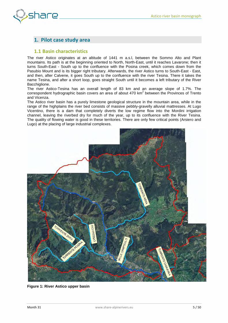
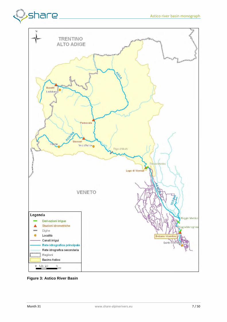
The river Astico originates at an altitude of 1441 m a.s.l, between the Sommo Alto and Plant mountains. Its path is at the beginning oriented to North, North-East, until it reaches Lavarone; then it turns South-East - South up to the confluence with the Posina creek, which comes down from the Pasubio Mount and is its bigger right tributary. Afterwards, the river Astico turns to South-East - East, and then, after Calvene, it goes South up to the confluence with the river Tesina. There it takes the name Tesina, and after a short loop, goes straight South until it becomes a left tributary of the River Bacchiglione. The river Astico-Tesina has an overall length of 83 km and an average slope of 1.7%. The correspondent hydrographic basin covers an area of about 470 km2 between the Provinces of Trento and Vicenza. The Astico river basin has a purely limestone geological structure in the mountain area, while in the range of the highplains the river bed consists of massive pebbly-gravelly alluvial mattresses. At Lugo Vicentino, there is a dam that completely diverts the low regime flow into the Mordini irrigation channel, leaving the riverbed dry for much of the year, up to its confluence with the River Tesina. The quality of flowing water is good in these territories. There are only few critical points (Arsiero and Lugo) at the placing of large industrial complexes.
Figure 1: River Astico upper basin
Astico river basin monograph
Month 31 www.share-alpinerivers.eu 6 / 50
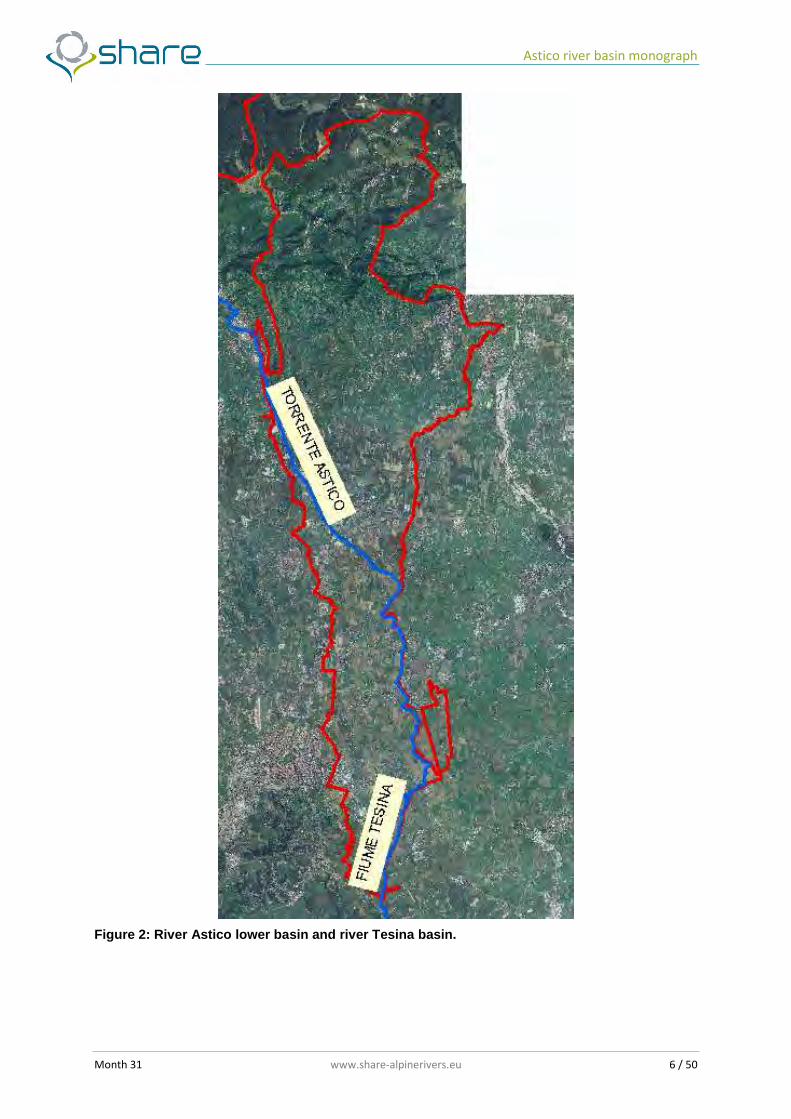
Figure 2: River Astico lower basin and river Tesina basin.
Astico river basin monograph
Month 31 www.share-alpinerivers.eu 7 / 50
Figure 3: Astico River Basin
Astico river basin monograph
Month 31 www.share-alpinerivers.eu 8 / 50
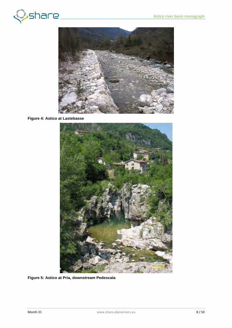
Figure 4: Astico at Lastebasse
Figure 5: Astico at Pria, downstream Pedescala
Astico river basin monograph
Month 31 www.share-alpinerivers.eu 9 / 50
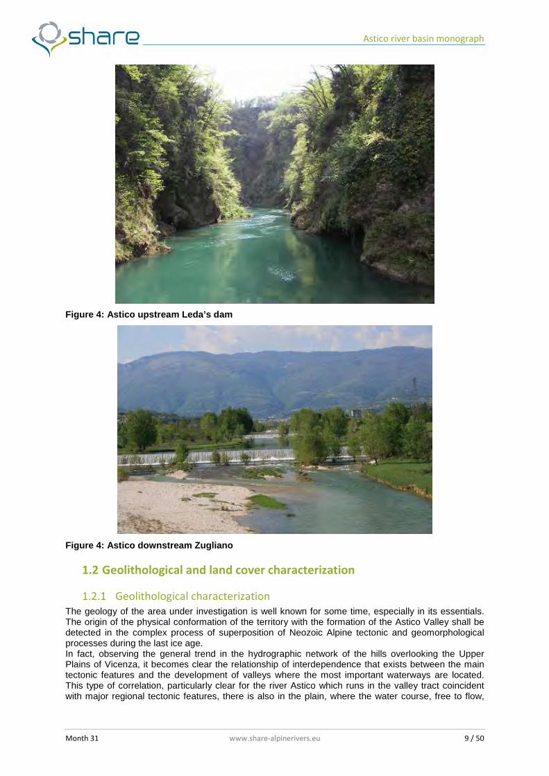
Figure 4: Astico upstream Leda’s dam
Figure 4: Astico downstream Zugliano
1.2 Geolithological and land cover characterization
1.2.1 Geolithological characterization
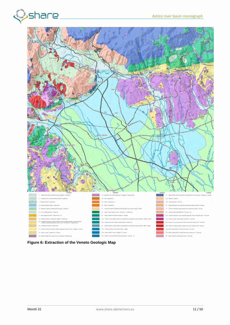
The geology of the area under investigation is well known for some time, especially in its essentials. The origin of the physical conformation of the territory with the formation of the Astico Valley shall be detected in the complex process of superposition of Neozoic Alpine tectonic and geomorphological processes during the last ice age. In fact, observing the general trend in the hydrographic network of the hills overlooking the Upper Plains of Vicenza, it becomes clear the relationship of interdependence that exists between the main tectonic features and the development of valleys where the most important waterways are located. This type of correlation, particularly clear for the river Astico which runs in the valley tract coincident with major regional tectonic features, there is also in the plain, where the water course, free to flow,
Astico river basin monograph
Month 31 www.share-alpinerivers.eu 10 / 50
was attracted to the fall line generated by tectonic deformation and dislocations. The effects of "recall" of these tectonic deviation in the plain had significant influence in determining an historical eastward migration of the stream. A number of palohydrographic studies have established the time evolution of the Astico showing how the river had originally its mouth between Caltrano and Piovene Rocchette, where the great alluvial fan, which passes through Vicenza and touches the Berici Mountains, begins. During the Upper Pleistocene, subsequent modeling glacial cycles produced by the Astico glacier and the post-glacial sediment overload, had significant effects throughout the study area as evidenced by the many forms of erosion and deposition found on the slopes and in the valley bottom. The Astico valley is in fact intensely shaped by glaciers as shown both by the morphology of the valley with steep sides and a large bottom flat alluvial valley (U-shaped) and by the number of present moraine features (moraine amphitheatres of Cogollo del Cengio) The relationship between river and groundwater in both plain and hilly zone is often characterized by a complicated hydrodynamic balance, where dispersion processes alternate and sometimes overlap with the charging process. In the hilly zone, ambivalent behaviours are present, associated with different geological domains. During its longitudinal development, the river Astico crosses two different hydrogeological domains:
- The hilly area, from the Leda dam to Breganze, dominated by limestone-dolomitic and marl-limestone reliefs of the Mesozoic age and by sedimentary and volcanic rocks of the Tertiary, covered on the valley bottom, by slopes deposits, river-glacier deposits and quaternary river sediments.
- The plain area, from Breganze to the springs line, characterized by a huge layer of undifferentiated Quaternary alluvial deposits.
The hills area The underground water circulation of the entire hills hydrologic system is characterized by a very tight interdependence rapport between the river and the valley groundwater. Loose deposits, of various origins, are characterized by phreatic underwater in dynamic equilibrium with the water course and with the contributes coming from the hills slopes. Inside this materials, the secondary circulation, sustained and driven by the bedrock (sometimes discovered by the erosion of the torrent), concentrates along the layers of coarse materials (sand and gravels), characterized by more permeability. Along the whole hilly reach, the river Astico receives an important though discontinuous alimentation, especially in the zone of the Asiago Plateu. The river, in turn, disperses the most of the discharge every time it meets a permeable layer, which saturation level is lower than the hydrometric level of the river. The early hilly zone, from the Leda dam to Caltrano, is characterized by steep slopes, often with rocky walls, very narrow secondary valleys, big channels and ridges of cohesive rocks, limestone and dolomite rocks with low porosity but high permeability due to cracks and fractures, and Karst phenomena, which favor the underground flow. The Mountains Paù, Cengio and Summano, which represent the valley geographic horizon, are constituted, in fact, by Triassic dolomite and limestone formations of the Lower Jurassic, characterized by widespread karst formations, favored by the chemical composition of the rock, especially for the Asiago plateau, which has a subhorizontal stratification. This explains the near absence of surface erosion, as the water flows underground. From Piovene to Caltrano, the left side of the valley is missing, thus opening an orographic window towards the plain, then the hills take the form of little reliefs of volcanic lithology, up to Calvene. In correspondence of this orographic window, constituent the apex part of the ancient alluvial fan of the Astico, there is the remarkable demonstration of the direction of the ancient glacier, and the Astico runs further east in a deep gorge carved by the river in its alluvial sediments with important effects by the hydro-geological point of view. In fact, in this river reach processes of dispersion are prevalent, and as we have seen for the highly permeable nature of the deposit (first cracked permeable dolomite and then gravel alluvial deposits) and for the presence of the ancient Astico’s riverbed, privileged axis of drainage. The next hilly reach, from Caltrano to Calvene, is instead characterized by the Foothill Flexure, featured by a different set and composition of formations. The high North side is in fact made of Upper Jurassic and Cretaceous rocks, with an inclined stratification, alternated to clay and marl formations. The final hilly zone of the Astico, up to Breganze-Sarcedo, develops turning to South direction, among low hills, mainly of volcanic origin, made of basalts, lava lines and stacks and more recent alluvial deposits.
Astico river basin monograph
Month 31 www.share-alpinerivers.eu 11 / 50
Figure 6: Extraction of the Veneto Geologic Map
Astico river basin monograph
Month 31 www.share-alpinerivers.eu 12 / 50
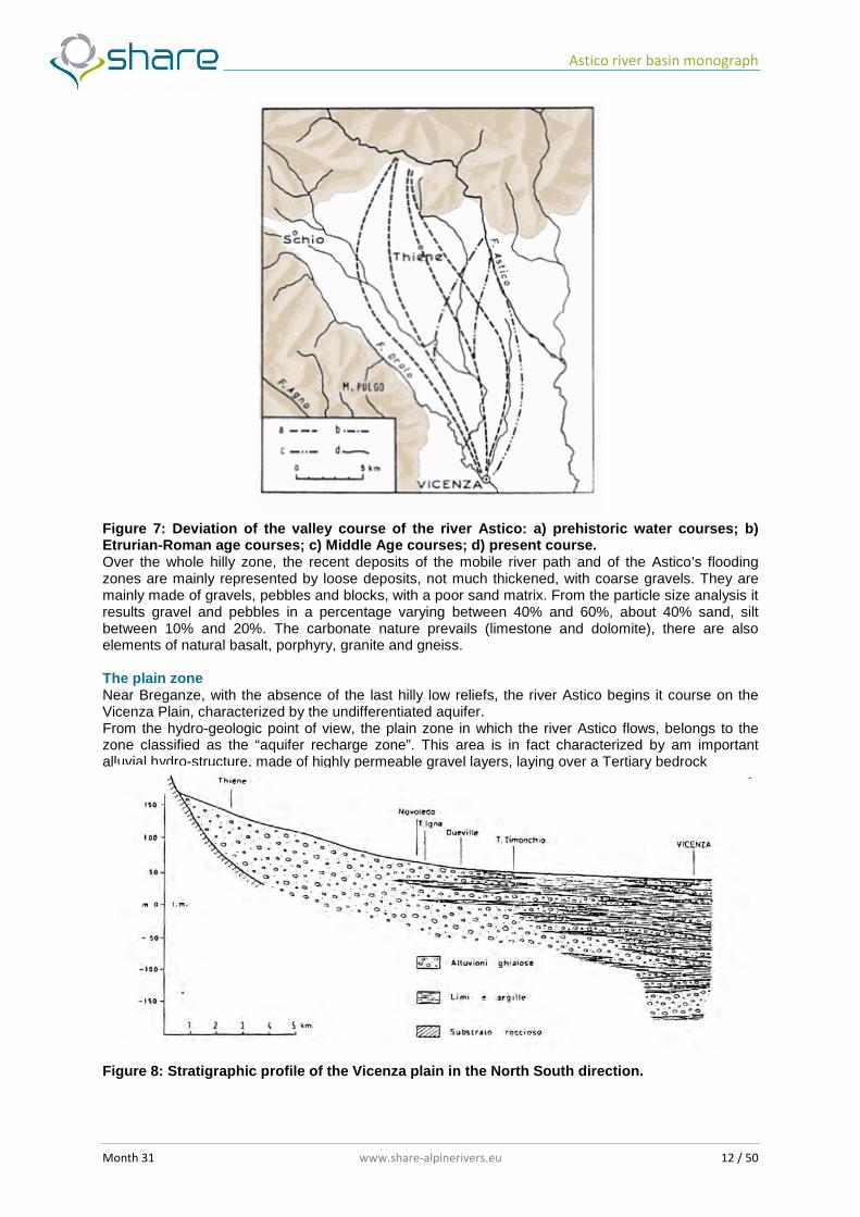
Figure 7: Deviation of the valley course of the river Astico: a) prehistoric water courses; b) Etrurian-Roman age courses; c) Middle Age courses; d) present course. Over the whole hilly zone, the recent deposits of the mobile river path and of the Astico’s flooding zones are mainly represented by loose deposits, not much thickened, with coarse gravels. They are mainly made of gravels, pebbles and blocks, with a poor sand matrix. From the particle size analysis it results gravel and pebbles in a percentage varying between 40% and 60%, about 40% sand, silt between 10% and 20%. The carbonate nature prevails (limestone and dolomite), there are also elements of natural basalt, porphyry, granite and gneiss. The plain zone Near Breganze, with the absence of the last hilly low reliefs, the river Astico begins it course on the Vicenza Plain, characterized by the undifferentiated aquifer. From the hydro-geologic point of view, the plain zone in which the river Astico flows, belongs to the zone classified as the “aquifer recharge zone”. This area is in fact characterized by am important alluvial hydro-structure, made of highly permeable gravel layers, laying over a Tertiary bedrock
Figure 8: Stratigraphic profile of the Vicenza plain in the North South direction.
Astico river basin monograph
Month 31 www.share-alpinerivers.eu 13 / 50
This composition is strictly related to the late Pleistocene-Holocene evolution of main water courses (Brenta and Astico) which, in correspondence of their valley inlet, built huge conoids and alluvial fans. This enormous volumes of alluvial gravel materials, highly permeable, and directly superposed over an impermeable rocky bed, represent the underground water reservoir. Going South, the acquifer becomes different, and has a multilayer structure, allowing the creation of artesian groundwater. The limit between the two hydro-geologic assets is more or less represented by the spring line. The phenomena, which originates the typical alignment of valley springs, is due to the progressive tapering of the alluvial deposits layer. These springs, fed by the phreatic aquifer, are distributed in a continuous belt in the East-West direction, and give origin to several rivers and canals.
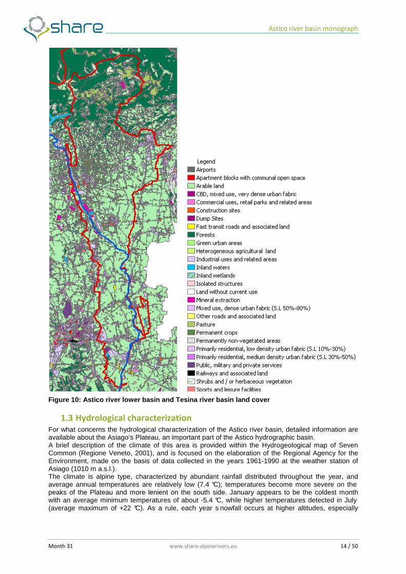
1.2.2 Land cover characterization
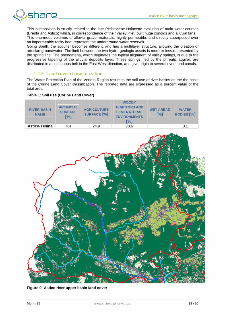
The Water Protection Plan of the Veneto Region resumes the soil use of river basins on the the basis of the Corine Land Cover classification. The reported data are expressed as a percent value of the total area:
Table 1: Soil use (Corine Land Cover)
RIVER BASIN NAME
ARTIFICIAL SURFACE
[%]
AGRICULTURE SURFACE [%]
WOODY TERRITORS AND SEMI-NATURAL ENVIRONMENTS
[%]
WET AREAS [%]
WATER BODIES [%]
Astico-Tesina 4.4 24.9 70.6 0.1
Figure 9: Astico river upper basin land cover
Astico river basin monograph
Month 31 www.share-alpinerivers.eu 14 / 50
Figure 10: Astico river lower basin and Tesina river basin land cover
1.3 Hydrological characterization For what concerns the hydrological characterization of the Astico river basin, detailed information are available about the Asiago’s Plateau, an important part of the Astico hydrographic basin. A brief description of the climate of this area is provided within the Hydrogeological map of Seven Common (Regione Veneto, 2001), and is focused on the elaboration of the Regional Agency for the Environment, made on the basis of data collected in the years 1961-1990 at the weather station of Asiago (1010 m a.s.l.). The climate is alpine type, characterized by abundant rainfall distributed throughout the year, and average annual temperatures are relatively low (7.4 °C); temperatures become more severe on the peaks of the Plateau and more lenient on the south side. January appears to be the coldest month with an average minimum temperatures of about -5.4 °C, while higher temperatures detected in July (average maximum of +22 °C). As a rule, each year s nowfall occurs at higher altitudes, especially

Astico river basin monograph
Month 31 www.share-alpinerivers.eu 15 / 50
during December to February, producing a snow accumulation on the ground that usually remains until the month of March-April. Regarding rainfall, the same document shows a map of the magnitude of the average annual rainfall, which highlights how the central band is more rainy than the southern and northern Europe. Through the data of daily precipitation measured in the years 1956-1994, it was possible to calculate the average monthly precipitation recorded at the two weather stations of Asiago and Campomezzavia the two stations were located at comparable altitudes (1010 and 1025 m a.s.l.) and about 7 km distant one another. Precipitation is well distributed throughout the year in both cases, with some modest increases during spring and autumn. On the contrary, we see that between the two stations there is a certain difference between the average annual rainfall, estimated to be about 250 mm .
Figure 11: Temperature and mean annual rainfall on the Asiago’s Plateau
Figure 12: Average monthly precipitation (years 1956-1994) for weather stations of Asiago and Campomezzavia. The wettest periods are spring-early summer and autumn.
The rainfall, however important, has only a part of the water resource, which quality and quantity is strongly influenced by the relationship between water and soil, in particular by the permeability and storage capacity.
Astico river basin monograph
Month 31 www.share-alpinerivers.eu 16 / 50
1.3.1 Flow regime
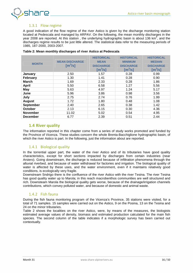
A good indication of the flow regime of the river Astico is given by the discharge monitoring station located at Pedescala and managed by ARPAV. On the following, the mean monthly discharges in the year 2008 are reported. At this station , the underlying hydrographic basin is about 136 km2, and the discharges regime results to be just little altered. The statistical data refer to the measuring periods of 1985, 187-2000, 2003-2007.
Table 2: Mean monthly discharges of river Astico at Pedescala
MONTH MEAN DISCHARGE [m 3/s]
HISTORICAL MEAN
DISCHARGE [m 3/s]
HISTORICAL MINIMUM
DISCHARGE [m 3/s]
HISTORICAL MEDIAN
DISCHARGE [m 3/s]
January 2.50 1.57 0.28 0.99 February 1.30 1.41 0.28 0.90 March 1.69 2.33 0.28 1.86 April 5.50 6.58 1.27 5.56 May 5.63 4.97 1.24 5.17 June 5.96 3.86 0.98 3.56 July 2.75 2.74 0.76 1.99 August 1.72 1.80 0.48 1.08 September 2.40 2.65 0.38 1.42 October 2.13 6.15 0.30 4.36 November 11.02 5.02 0.54 4.95 December 6.77 2.39 0.51 2.44
1.4 River quality The information reported in this chapter come from a series of study works promoted and funded by the Province of Vicenza. These studies concern the whole Brenta-Bacchiglione hydrographic basin, of which the river Astico is part. In the following, just the information about are reported.
1.4.1 Biological quality
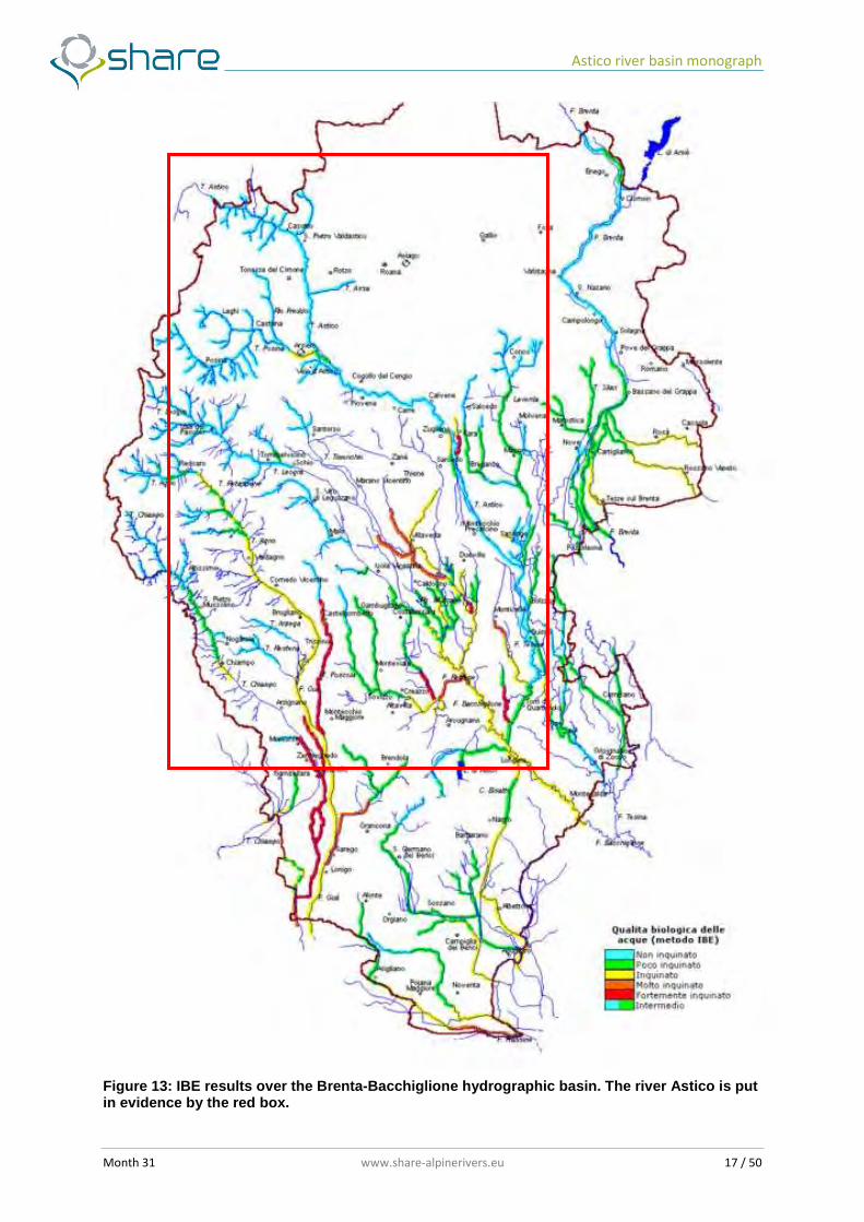
In the torrential upper part, the water of the river Astico and of its tributaries have good quality characteristics, except for short sections impacted by discharges from certain industries (near Arsiero). Going downstream, the discharge is reduced because of infiltration phenomena through the alluvial riverbed, and because of water withdrawal for factories and irrigation. The biological quality of water is affected by these uses, and the water environment, even if it maintains relatively good conditions, is ecologically very fragile. Downstream Sndrigo there is the confluence of the river Astico with the river Tesina. The river Tesina has good quality water up to Marola; in this reach macrobenthos communities are well structured and rich. Downsteam Marola the biological quality gets worse, because of the drainage/irrigation channels contributions, which convey polluted water, and because of domestic and animal waste.
1.4.2 Fish fauna
During the fish fauna monitoring program of the Vicenza’s Province, 35 stations were visited, for a total of 71 samples. 15 samples were carried out on the Astico, 9 on the Posina, 13 on the Tesina and 24 on the minor tributaries. Table 2 shows the localities on the river Astico, were, by means of the measures, the biologists estimated average values of density, biomass and estimated production calculated for the main fish species. The second column of the table indicates if a morphologic survey has been carried out contextually.
Astico river basin monograph
Month 31 www.share-alpinerivers.eu 17 / 50
Figure 13: IBE results over the Brenta-Bacchiglione hydrographic basin. The river Astico is put in evidence by the red box.

Astico river basin monograph
Month 31 www.share-alpinerivers.eu 18 / 50
Table 3: IBE classification legend
COLOUR QUALITY CLASS DEFINITION I Unaltered environment II Slightly altered environment III Altered environment IV Highly altered environment V Extremely altered environment
Intermediate conditions
Table 4: Fish surveys and morphological monitoring stations
STATION MORPHOLOGIC SURVEY YEAR 1987/88 YEAR 1992
Busatti ● ● ● Ciechi (upstream the bridge) ● Ponte Posta ● Sella ● Ponte Maso ● Ponte Basso ● Pedescala’s bridge ● ● ● La Pria (Scalini) ● Arsiero (Ravari) ● ● ● Ponte degli Schiri (Arsiero) ● San Giorgio ● Ponte Granatieri (Caltrano) ● Ponte Calvene ● ● Passo di riva ● Chiuppano ● Lugo Vicentino ● Lupia (Sandrigo) ● ● The surveyed fish species were:rainbow trout, brown trout, bullhead, lucio, tench. On the Astico river, from Arsiero to the upstream, the density of brown trout was very good in 1987 prformed samples, with average values of 0.526 ind/m2 and average biomass of 26.54 g/m2. The latter value is certainly not representative of the entire river reach, but it is overestimated for the contribution of the population found in the station AT 15 (Pedescala). Even during the 1992 monitoring, good values of density (0.298 ind/m2) and biomass (25.433 g/m2) were found, but also these data were offset by the high values found in the station A15. In the Posina, both the average density (0.118 ind/m2)and the estimated biomass (6.793 g/m2) resulted lower, while in 1992 the values were: density = 0.068 ind/m2 and biomass = 5.523 g/m2. On minor tributaries, the brown trot density is always good (0.582 ind/m2 for the Astico’s tributaries and 0.362 ind/m2 for the posina tributaries) as well as estimated biomass is about 16.340 g/m2 e 11.169 g/m2 respectively, in 1987. Inside the basins of the Torrent Laverda, of the Chiavone Bianco and of the Chiavone Nero, the average fish density is 0.891 ind/m2. This value is strongly influenced by the high density locally surveyed on the Chiavone Bianco, on a reach subjected to annual fish input. The average biomass is estimated to be about 7.096 g/m2. In the river Tesina, salmonid population is greatly reduced because of the poor contribution of the natural reproduction. Both biomass density of brown trout are very low (density = 0.009 ind./m2 and biomass = 1770 g/m2). The rainbow trout were caught only on the T. Astico, in the reach between the bridge of Pedescala and Arsiero, were the environmental conditions are more suitable for their ecologic requirements. The population has an average density of 0,087 ind./m2 and an estimated average biomass of 7225 g/m2 (data of 1987). The subsequent 1992 monitoring activity showed a further deteriorated situation. Also in this river, cases of hybridization between rainbow trout and brown trout are evident. This phenomena, leading to a further loss of purity of the marble trout specie, endangers the survival of this semi-specie in this environments.

Astico river basin monograph
Month 31 www.share-alpinerivers.eu 19 / 50
The bullhead is present over the whole T.Astico and T.Posina, and in some tributaries. Both the average density (0.371 ind/m2) and the average estimated biomass (6.306 g/m2) are fair. In the T.Posina, which is subjected to heavy discharge fluctuations (in some places it remains dry for long periods) the bullhead population is lower, with average density 0.062 ind/m2. In the few tributaries were this fish was found, the density resulted to be 0.413 ind/m2 and the biomass 4.04 g/m2 (1987). In the stations downstream Arsiero, the aquatic environment modifies as a consequences of the decreasing slope of the riverbed and of the flow velocity. The environmental typology and the bottom morphology allow the colonization of certain fish species populations, such as reophil chub (Leucisus cephalus), barbell and canine minnow as well as benthic species such as the goby and the common loach (Cobitis taenia). In the T.Tesina the fish community is mainly composed of cyprinidis in the upper reach, while in the lower reach, also reophil species appear, accompanied by eel, pike, loach and gudgeon.
Figure 14: Fish fauna sampling stations.
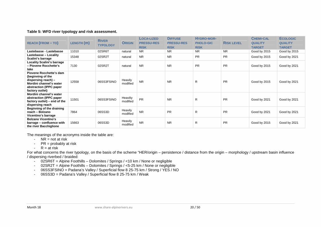
1.4.3 WFD River Typology
The river typology belonging to the Astico river basin, are individuated in the Eastern Alps hydrographic basin management plan, edited by the Eastern Alps basin Authority. The Astico-Tesina basin results to be composed by 4 river typologies.
Month 18 www.share-alpinerivers.eu 20 / 50
Table 5: WFD river typology and risk assessment.
REACH (FROM – TO) LENGTH (m) RIVER TYPOLOGY ORIGIN
LOCA-LIZED PRESSU-RES RISK
DIFFUSE PRESSU-RES RISK
HYDRO-MOR-PHOLO-GIC RISK
RISK LEVEL CHEMI-CAL QUALITY TARGET
ECOLOGIC QUALITY TARGET
Lastebasse - Lastebasse 11010 02SR6T natural NR NR NR NR Good by 2015 Good by 2015 Lastebasse – Locality Scalini’s barrage 15348 02SR2T natural NR NR PR PR Good by 2015 Good by 2021
Locality Scalini’s barrage – Piovene Rocchette’s lake
7130 02SR2T natural NR NR PR PR Good by 2015 Good by 2021
Piovene Rocchette’s dam (beginning of the dispersing reach) – Mordini channel’s water abstraction (IPPC paper factory outlet)
12558 06SS3FSINO Heavily modified NR NR R PR Good by 2015 Good by 2021
Mordini channel’s water abstraction (IPPC paper factory outlet) – end of the dispersing reach
11501 06SS3FSINO Heaviliy modified
PR NR R PR Good by 2021 Good by 2021
Beginning of the draining reach – Bolzano Vicentino’s barrage
7864 06SS3D Heavily modified NR PR R PR Good by 2021 Good by 2021
Bolzano Vicentino’s barrage – confluence with the river Bacchiglione
15663 06SS3D Heavily modified
NR NR R PR Good by 2015 Good by 2021
The meanings of the acronyms inside the table are:
- NR = not at risk - PR = probably at risk - R = at risk
For what concerns the river typology, on the basis of the scheme “HER/origin – persistence / distance from the origin – morphology / upstream basin influence / dispersing riverbed / braided:
- 02SR6T = Alpine Foothills – Dolomites / Springs / <10 km / None or negligible - 02SR2T = Alpine Foothills – Dolomites / Springs / <5-25 km / None or negligible - 06SS3FSINO = Padana’s Valley / Superficial flow 8 25-75 km / Strong / YES / NO - 06SS3D = Padana’s Valley / Superficial flow 8 25-75 km / Weak
Month 18 www.share-alpinerivers.eu 21 / 50
2. Plans and management programs
2.1 Existing management plans and application rules
2.1.1 The Regional Territorial Plan of Coordination (PTRC) of Veneto Region
The PTRC of Veneto Region defines the regional policies oriented to achieve a balanced general environmental leading, together with the productive, and the "social" destination of land resources. The predicted balance must therefore be achieved by:
- soil conservation and safety of settlements through active prevention of hydrogeological disorder and reconstruction of degraded areas
- pollution control of primary resources (air, water, soil) - the protection and conservation of natural or near-natural environments (flora and fauna
resources, geology, wetlands, etc.) - protection and enhancement of historical-cultural heritage (historical centers, isolated
monuments, documents, culture, Veneto history and tradition, rural landscapes, infrastructure and historic 'signs')
- enhancement of agricultural areas, including their fundamental role in balance and environmental protection.
In particular, in the field of environmental remediation and water pollution protection, the PTRC has the following objectives:
- protecting the sources of drinking water supply - minimizing the production and the movement of environmental pollutants
2.1.2 The General Plan of Waterworks (PRGA) of Veneto Region
In synthesis this plan prescribes: - general use of groundwater, with the abandonment of surface water, kept only in small
quantities to meet peak seasonal needs, especially in areas of predominantly tourist function. - rationalization of the sources already used in mountainous areas, with reserve solely for water
distribution of precious water resources currently used for irrigation or industrial use and with the usage of sources not used.
- rationalization of the structural and management aspects by identifying Bodies of water distribution in optimal size, based on technical and managerial considerations of the most relevant and significant parameters.
2.1.3 The Regional Plan of Drainage Water (PRRA) of Veneto Region
The strategies used by the PRRA to achieve the optimal protection degree of the aquatic environment consist in the following fundamental choices: 1. Identification, over the region territory, of homogeneous spatial sections, so defined: - the zone of hills and mountains. It consists of the Dolomite mountains of Belluno and mountain and hill areas of various shape and origin bordering the north side of the Veneto - the range of aquifer recharge in the foothills. It consists of alluvial fans deposited by streams outgoing from river mountain. This area, which has high permeability soils, it has the maximum contribution to feeding the underground aquifers. - the lowlands. Downstream of the line of springs was originally a myriad of ditches that are only partially fed streams from upstream, mostly enclosed by embankments, while giving home to many small waterways are characterized by a significant permanence of flow rates and, at least at the source, a good water quality. - the coastal zone, represented by the mouths of the rivers and link channels. 2. Splitting the region into homogeneous areas characterized by different levels of protection, on the basis of vulnerability of water bodies, of them use and of the hydrographic and of the geomorphological characteristics and of land settlement. Homogeneous regions are so identified: - The mountain foothills and mountains zones, including the mountains of the whole province of Belluno and the northern areas the provinces of Treviso, Padua, Vicenza and Verona, this
Astico river basin monograph
Month 31 www.share-alpinerivers.eu 22 / 50
homogeneous zone is characterized by low population density, by limited industrial settlements, a rich and distributed hydrographic network, with morphological characteristics of river beds profiles which generally favour a good oxygenation of the water. - The range of groundwater recharge, located between the south mountain area and the range of springs, that area, formed by powerful alluvial fans consist mainly of coarse materials deposited by rivers edge of the mountain basin. For this peculiar morphological structure, this zone is a large reservoir of water which feeds the underground water in the plain below, and through the springs, several streams. On the one hand, the high permeability of land without great risk of contamination - particularly from conservative pollutants – of groundwater bodies with grave harm due to many uses, including drinking water, existing and projected. On the other, especially the high concentration of industrial settlements makes this risk very real and present. However, there are some areas marked by the presence of less permeable soils and defined low risk. - The lowlands extending from the end of the springs zone to the coast, including one part the major urban centers, and the other with purely agricultural vocation, like the territories of Eastern Veneto. The lowlands are characterized by a very dense river network of natural and articulate waterways, drainage and irrigation channels, where the man work has significantly altered the natural regime of outflows in the purpose, not always achieved, to optimize the use of the resource. These interventions, and the intensive uses which are subject, make the courses particularly exposed to concentrated plain water discharges and could not have massive or high dilution or elimination capacity or hydrodynamic conditions suitable for natural pollution residual elimination. Precisely because of these features, it seemed appropriate to divide the strip into two areas characterized by different densities of settlements and establishing the threshold value to 600 equivalent inhabitants per square kilometre. - the coastal area between the coastline and a conventional fixed border. The identification of this range is justified for the vulnerability of the delicate trophic balance of High Adriatic coastal waters. These characteristics are exacerbated by the high settlements concentration in the tourist strip. 3. Differentiation of treatment degree, as a function of plant potential and of the location of the discharge. In application of the criterion of territory division into homogeneous groups, the PRRA adopt the principle of diversification of treatment degree, as a function of plant potential and of the location of the discharge. In essence, the limits of acceptability of the discharge of public sewers and civil settlements not discharging into public sewers shall be based on tables for different groups according to the size and homogeneous population served in terms of population equivalents, requiring different values, even taking into account the prevailing use of the resource. Finally, the plan takes into account special requirements related to the ability of self-purification and dilution of the receiving water. The entire region is divided into 52 aggregates, which are grouped into best geographical areas. For each aggregate, the plan shows the position of existing structures and the proposal solution, which in some cases provides variants with different levels of aggregation. Assuming that a proper evaluation impact of a discharge in a water body must take into account on one hand the total amount of receptor-dependent part of pollutant and the degree of treatment of the used water. The Plan articulates the different levels of sewage treatment. 4. General guidelines for the discharge of purified sewage waters. The sewage effluent treatment is not limited to the treatment process. The self-purification or possible residual accumulation depend strongly on the hydrological regime of the recipient. The legislation aims to adapt to these concepts, in particular prohibiting direct discharges into the subsoil and lakes. and taking particularly caution in the case of watercourses designed to drinking use. It also sets a dilution limit of sewage water discharge which takes into account the natural resilience of the watercourse. However the legislation allows exceeding the limit for particular substances (sulfates and chlorides) if the water receptor of conditions still retain their existing uses.
2.1.4 National and Regional Energy Plan
An important objective of PEN is the improvement of environmental conditions of use of energy, obtained in agreement with the energy policy of the EEC, through, inter alia, the use of renewable sources. In this sense, the Regional Energy Plan, actuator instrument of PEN, according to law 10/1991, proposes, as regards hydropower, the realization of a series of average hydroelectric power, already part of the ENEL programming, and other low-power, already at that time included in the programs of Reclamation Consortia.
Astico river basin monograph
Month 31 www.share-alpinerivers.eu 23 / 50
2.1.5 Regional Water Protection Plan
The water protection plan includes the following three main sections: - State of the art: it summarizes the knowledge base and includes an analysis of critical
situations for surface water and underground water, for the hydrologic and hydrographic river basins.
- Plan Proposal: it contains the identification of quality objects, general measures and specific actions planned to achieve them. It includes also the appointment of sensitive areas, areas vulnerable to nitrate and plant protection products, the areas subject to soil degradation and desertification.
- Technical Regulations for Implementation: contains the regulation of discharges, the discipline for areas requiring specific measures to prevent pollution and sanitation, such as guidelines for environmental protection and water saving.
Astico river basin monograph
Month 31 www.share-alpinerivers.eu 24 / 50
3. Water uses
All the information reported in the following are taken by a recent study performed by ARPAV and committed by the Province of Vicenza, dealing about the water resource availability on the hydrographic basin of the river Astico.
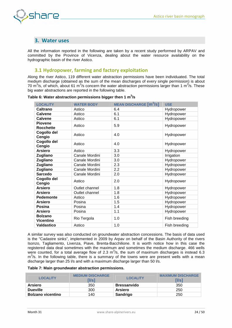
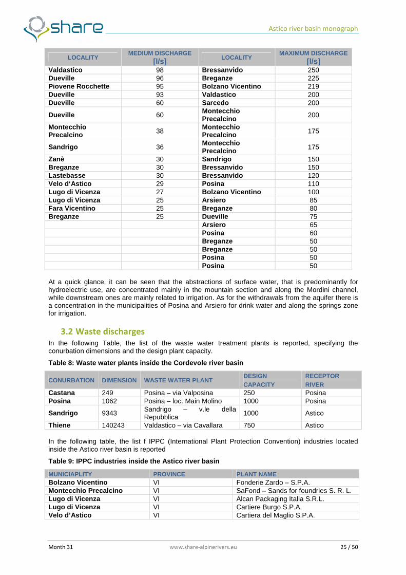
3.1 Hydropower, farming and factory exploitation Along the river Astico, 119 different water abstraction permissions have been individuated. The total medium discharge (obtained as the sum of the mean discharges of every single permission) is about 70 m3/s, of which, about 61 m3/s concern the water abstraction permissions larger than 1 m3/s. These big water abstractions are reported in the following table.
Table 6: Water abstraction permissions bigger then 1 m 3/s
LOCALITY WATER BODY MEAN DISCHARGE [m 3/s] USE Caltrano Astico 6.4 Hydropower Calvene Astico 6.1 Hydropower Calvene Astico 6.1 Hydropower Piovene Rocchette Astico 5.9 Hydropower
Cogollo del Cengio Astico 4.0 Hydropower
Cogollo del Cengio Astico 4.0 Hydropower
Arsiero Astico 3.3 Hydropower Zugliano Canale Mordini 3.0 Irrigation Zugliano Canale Mordini 3.0 Hydropower Zugliano Canale Mordini 2.3 Hydropower Zugliano Canale Mordini 2.2 Hydropower Sarcedo Canale Mordini 2.0 Hydropower Cogollo del Cengio Astico 2.0 Hydropower
Arsiero Outlet channel 1.8 Hydropower Arsiero Outlet channel 1.8 Hydropower Pedemonte Astico 1.6 Hydropower Arsiero Posina 1.5 Hydropower Posina Posina 1.4 Hydropower Arsiero Posina 1.1 Hydropower Bolzano Vicentino Rio Tergola 1.0 Fish breeding
Valdastico Astico 1.0 Fish breeding A similar survey was also conducted on groundwater abstraction concessions. The basis of data used is the "Cadastre sinks”, implemented in 2009 by Arpav on behalf of the Basin Authority of the rivers Isonzo, Tagliamento, Livenza, Piave, Brenta-Bacchilione. It is worth notice how in this case the registered data deal sometimes with the maximum and sometimes the medium discharge. 466 wells were counted, for a total average flow of 2.3 m3/s, the sum of maximum discharges is instead 6.3 m3/s. In the following table, there is a summary of the towns were are present wells with a mean discharge larger than 25 l/s and with a maximum discharge larger than 50 l/s.
Table 7: Main groundwater abstraction permissions.
LOCALITY MEDIUM DISCHARGE [l/s] LOCALITY MAXIMUM DISCHARGE
[l/s] Arsiero 350 Bressanvido 350 Dueville 300 Arsiero 250 Bolzano vicentino 140 Sandrigo 250
Astico river basin monograph
Month 31 www.share-alpinerivers.eu 25 / 50
LOCALITY MEDIUM DISCHARGE [l/s] LOCALITY MAXIMUM DISCHARGE
[l/s] Valdastico 98 Bressanvido 250 Dueville 96 Breganze 225 Piovene Rocchette 95 Bolzano Vicentino 219 Dueville 93 Valdastico 200 Dueville 60 Sarcedo 200
Dueville 60 Montecchio Precalcino 200
Montecchio Precalcino 38
Montecchio Precalcino 175
Sandrigo 36 Montecchio Precalcino 175
Zanè 30 Sandrigo 150 Breganze 30 Bressanvido 150 Lastebasse 30 Bressanvido 120 Velo d‘Astico 29 Posina 110 Lugo di Vicenza 27 Bolzano Vicentino 100 Lugo di Vicenza 25 Arsiero 85 Fara Vicentino 25 Breganze 80 Breganze 25 Dueville 75 Arsiero 65 Posina 60 Breganze 50 Breganze 50 Posina 50 Posina 50 At a quick glance, it can be seen that the abstractions of surface water, that is predominantly for hydroelectric use, are concentrated mainly in the mountain section and along the Mordini channel, while downstream ones are mainly related to irrigation. As for the withdrawals from the aquifer there is a concentration in the municipalities of Posina and Arsiero for drink water and along the springs zone for irrigation.
3.2 Waste discharges
In the following Table, the list of the waste water treatment plants is reported, specifying the conurbation dimensions and the design plant capacity.
Table 8: Waste water plants inside the Cordevole river basin
CONURBATION DIMENSION WASTE WATER PLANT DESIGN CAPACITY
RECEPTOR RIVER
Castana 249 Posina – via Valposina 250 Posina Posina 1062 Posina – loc. Main Molino 1000 Posina
Sandrigo 9343 Sandrigo – v.le della Repubblica
1000 Astico
Thiene 140243 Valdastico – via Cavallara 750 Astico In the following table, the list f IPPC (International Plant Protection Convention) industries located inside the Astico river basin is reported
Table 9: IPPC industries inside the Astico river basin
MUNICIAPLITY PROVINCE PLANT NAME Bolzano Vicentino VI Fonderie Zardo – S.P.A. Montecchio Precalcino VI SaFond – Sands for foundries S. R. L. Lugo di Vicenza VI Alcan Packaging Italia S.R.L. Lugo di Vicenza VI Cartiere Burgo S.P.A. Velo d’Astico VI Cartiera del Maglio S.P.A.
Astico river basin monograph
Month 31 www.share-alpinerivers.eu 26 / 50
3.3 Drinking water There are no water withdrawals from surface water bodies for drinking purposes.
3.4 Touristic fruition Water withdrawals linked to touristic activities mainly concern artificial snowing in the upper basin. Six activities are present, and the amount of water abstraction is 8 l/s, corresponding to a total volume of about 250.000 m3.
Astico river basin monograph
Month 31 www.share-alpinerivers.eu 27 / 50
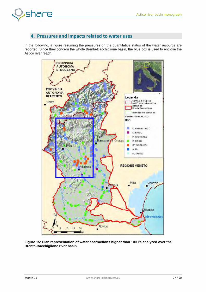
4. Pressures and impacts related to water uses
In the following, a figure resuming the pressures on the quantitative status of the water resource are reported. Since they concern the whole Brenta-Bacchiglione basin, the blue box is used to enclose the Astico river reach.
Figure 15: Plan representation of water abstractions higher than 100 l/s analyzed over the Brenta-Bacchiglione river basin.
Astico river basin monograph
Month 31 www.share-alpinerivers.eu 28 / 50
5. Restoration and mitigation actions
River restoration and mitigation actions are generally recommended in the Management Plan of River Piave Basin, in which the Astico and all its tributaries are included. These kind of actions are indicated both for hydraulic risk reduction and for biological quality improvement. However, at the moment, no specific works are planned for the Astico river basin.
Astico river basin monograph
Month 31 www.share-alpinerivers.eu 29 / 50
6. Channel reach MCA application description
6.1 Channel reach morphological characteristics
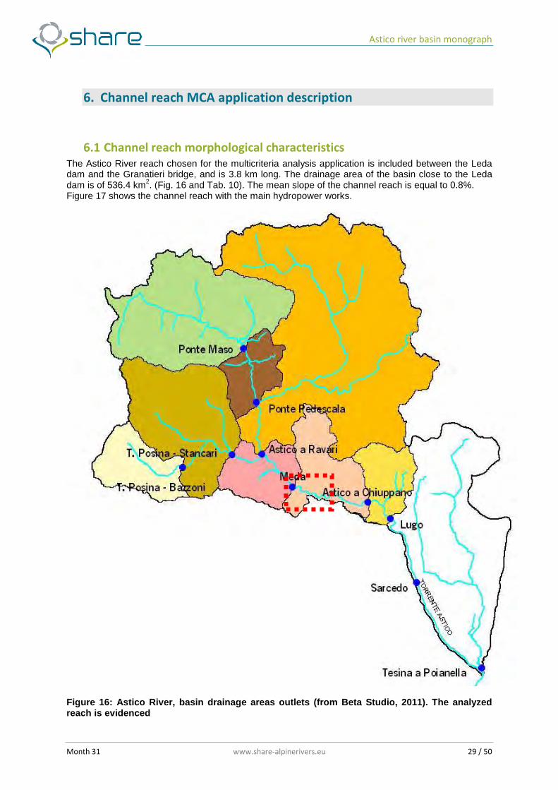
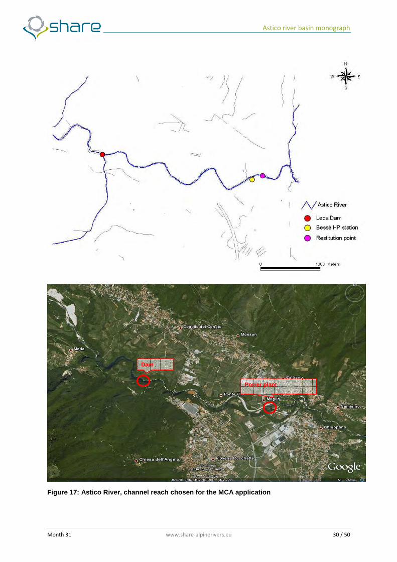
The Astico River reach chosen for the multicriteria analysis application is included between the Leda dam and the Granatieri bridge, and is 3.8 km long. The drainage area of the basin close to the Leda dam is of 536.4 km2. (Fig. 16 and Tab. 10). The mean slope of the channel reach is equal to 0.8%. Figure 17 shows the channel reach with the main hydropower works.
Figure 16: Astico River, basin drainage areas outlets (from Beta Studio, 2011). The analyzed reach is evidenced
Astico river basin monograph
Month 31 www.share-alpinerivers.eu 30 / 50
Figure 17: Astico River, channel reach chosen for the MCA application
Dam
Power plant
Astico river basin monograph
Month 31 www.share-alpinerivers.eu 31 / 50
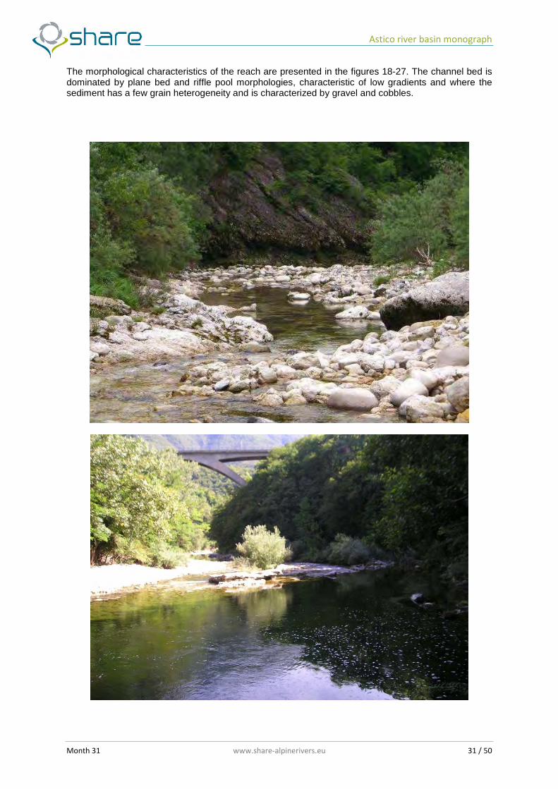
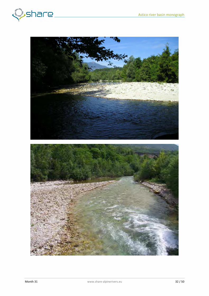
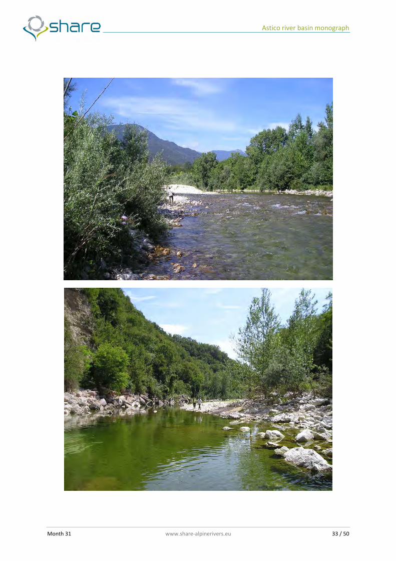
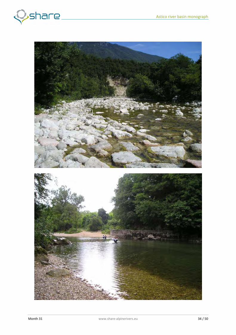
The morphological characteristics of the reach are presented in the figures 18-27. The channel bed is dominated by plane bed and riffle pool morphologies, characteristic of low gradients and where the sediment has a few grain heterogeneity and is characterized by gravel and cobbles.
Astico river basin monograph
Month 31 www.share-alpinerivers.eu 32 / 50
Astico river basin monograph
Month 31 www.share-alpinerivers.eu 33 / 50
Astico river basin monograph
Month 31 www.share-alpinerivers.eu 34 / 50

Astico river basin monograph
Month 31 www.share-alpinerivers.eu 35 / 50
Figures 18-27: Astico River. Reach downstream Leda dam; dominating channel bed morphologies
Astico river basin monograph
Month 31 www.share-alpinerivers.eu 36 / 50
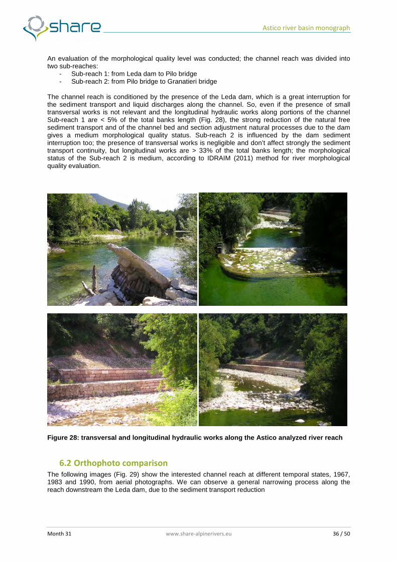
An evaluation of the morphological quality level was conducted; the channel reach was divided into two sub-reaches:
- Sub-reach 1: from Leda dam to Pilo bridge - Sub-reach 2: from Pilo bridge to Granatieri bridge
The channel reach is conditioned by the presence of the Leda dam, which is a great interruption for the sediment transport and liquid discharges along the channel. So, even if the presence of small transversal works is not relevant and the longitudinal hydraulic works along portions of the channel Sub-reach 1 are < 5% of the total banks length (Fig. 28), the strong reduction of the natural free sediment transport and of the channel bed and section adjustment natural processes due to the dam gives a medium morphological quality status. Sub-reach 2 is influenced by the dam sediment interruption too; the presence of transversal works is negligible and don’t affect strongly the sediment transport continuity, but longitudinal works are > 33% of the total banks length; the morphological status of the Sub-reach 2 is medium, according to IDRAIM (2011) method for river morphological quality evaluation.
Figure 28: transversal and longitudinal hydraulic works along the Astico analyzed river reach
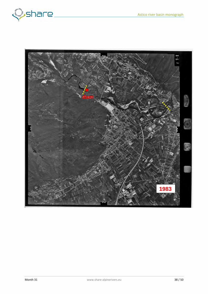
6.2 Orthophoto comparison
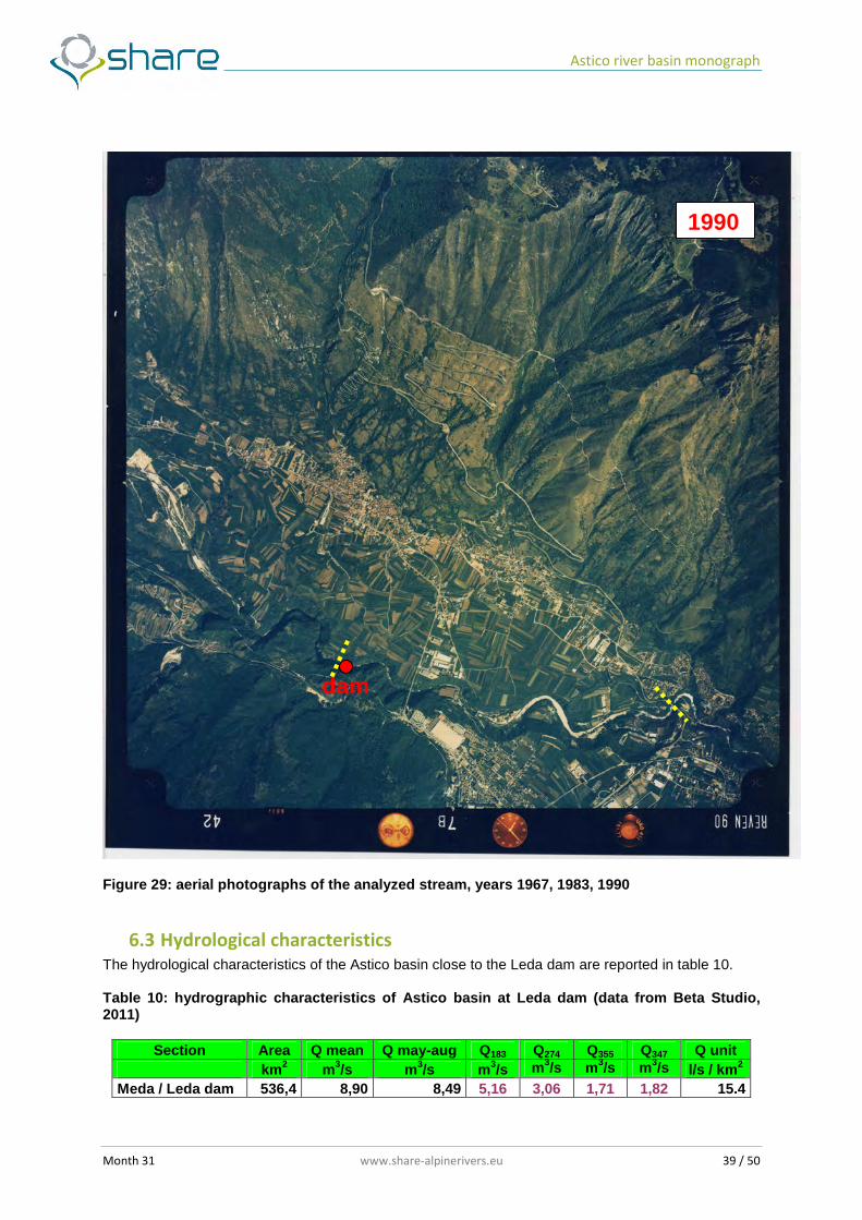
The following images (Fig. 29) show the interested channel reach at different temporal states, 1967, 1983 and 1990, from aerial photographs. We can observe a general narrowing process along the reach downstream the Leda dam, due to the sediment transport reduction

Astico river basin monograph
Month 31 www.share-alpinerivers.eu 37 / 50
1967
dam
Astico river basin monograph
Month 31 www.share-alpinerivers.eu 38 / 50
1983
dam
Astico river basin monograph
Month 31 www.share-alpinerivers.eu 39 / 50
Figure 29: aerial photographs of the analyzed stream, years 1967, 1983, 1990
6.3 Hydrological characteristics The hydrological characteristics of the Astico basin close to the Leda dam are reported in table 10. Table 10: hydrographic characteristics of Astico basin at Leda dam (data from Beta Studio, 2011)
Section Area Q mean Q may-aug Q183 Q274 Q355 Q347 Q unit km 2 m3/s m3/s m3/s m3/s m3/s m3/s l/s / km 2
Meda / Leda dam 536,4 8,90 8,49 5,16 3,06 1,71 1,82 15.4
1990
dam
Astico river basin monograph
Month 31 www.share-alpinerivers.eu 40 / 50
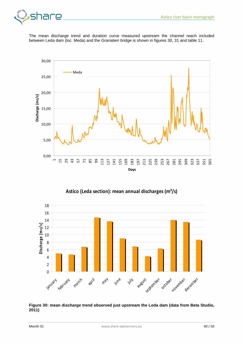
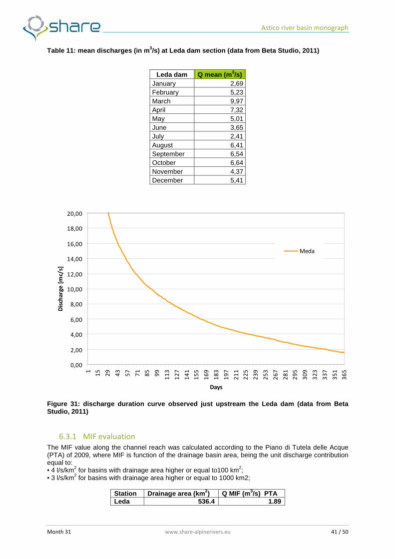
The mean discharge trend and duration curve measured upstream the channel reach included between Leda dam (loc. Meda) and the Granatieri bridge is shown in figures 30, 31 and table 11.
0,00
5,00
10,00
15,00
20,00
25,00
30,00
1
15
29
43
57
71
85
99
11
3
12
7
14
1
15
5
16
9
18
3
19
7
21
1
22
5
23
9
25
3
26
7
28
1
29
5
30
9
32
3
33
7
35
1
36
5
Days
Dis
cha
rge
[m
c/s]
Meda
Astico (Leda section): mean annual discharges (m³/s)
0
2
4
6
8
10
12
14
16
18
januar
y
febru
ary
marc
hapril m
ayju
neju
ly
august
septe
mber
october
november
decembe
r
Dis
cha
rge
[m
c/s]
Figure 30: mean discharge trend observed just upstream the Leda dam (data from Beta Studio, 2011)
Astico river basin monograph
Month 31 www.share-alpinerivers.eu 41 / 50
Table 11: mean discharges (in m 3/s) at Leda dam section (data from Beta Studio, 2011)
Leda dam Q mean (m 3/s) January 2,69 February 5,23 March 9,97 April 7,32 May 5,01 June 3,65 July 2,41 August 6,41 September 6,54 October 6,64 November 4,37 December 5,41
0,00
2,00
4,00
6,00
8,00
10,00
12,00
14,00
16,00
18,00
20,00
1
15
29
43
57
71
85
99
11
3
12
7
14
1
15
5
16
9
18
3
19
7
21
1
22
5
23
9
25
3
26
7
28
1
29
5
30
9
32
3
33
7
35
1
36
5
Days
Dis
cha
rge
[m
c/s]
Meda
Figure 31: discharge duration curve observed just upstream the Leda dam (data from Beta Studio, 2011)
6.3.1 MIF evaluation
The MIF value along the channel reach was calculated according to the Piano di Tutela delle Acque (PTA) of 2009, where MIF is function of the drainage basin area, being the unit discharge contribution equal to: • 4 l/s/km2 for basins with drainage area higher or equal to100 km2; • 3 l/s/km2 for basins with drainage area higher or equal to 1000 km2;
Station Drainage area (km2) Q MIF (m3/s) PTA Leda 536.4 1.89
Astico river basin monograph
Month 31 www.share-alpinerivers.eu 42 / 50
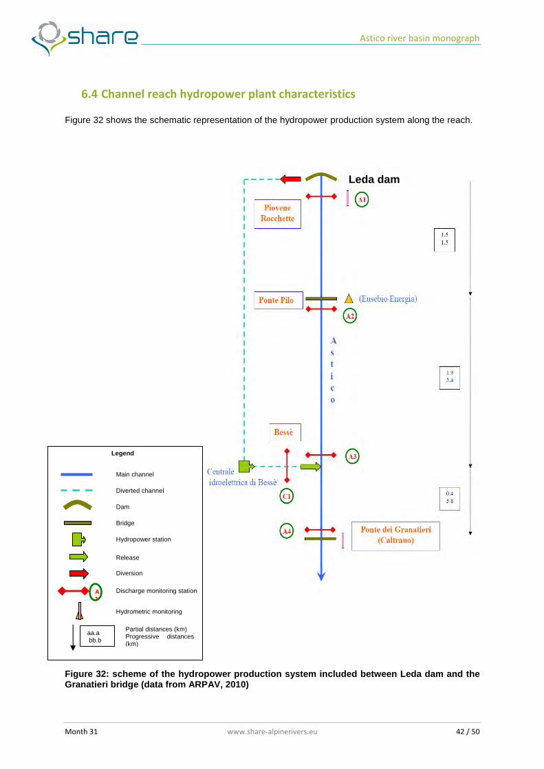
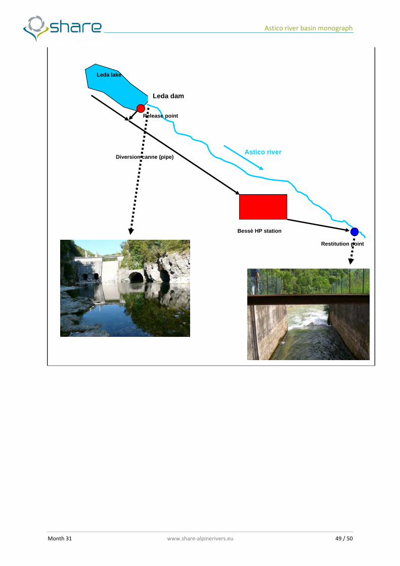
6.4 Channel reach hydropower plant characteristics Figure 32 shows the schematic representation of the hydropower production system along the reach.
Figure 32: scheme of the hydropower production system included between Leda dam and the Granatieri bridge (data from ARPAV, 2010)
aa.a bb.b
Hydrometric station Hydrometric monitoring
Partial distances (km) Progressive distances (km)
Main channel
Diverted channel
Dam
Bridge
Release
Diversion
Discharge monitoring station
Hydropower station
Legend
A1
Leda dam
Astico river basin monograph
Month 31 www.share-alpinerivers.eu 43 / 50
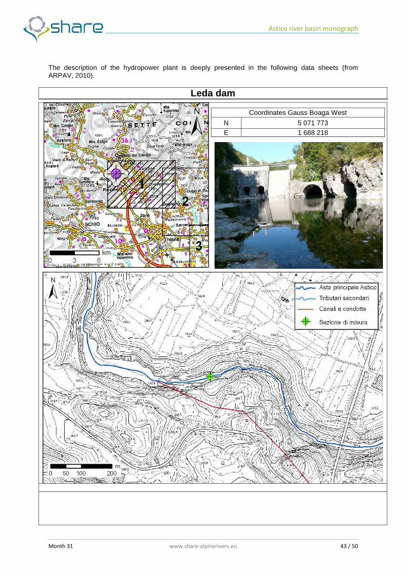
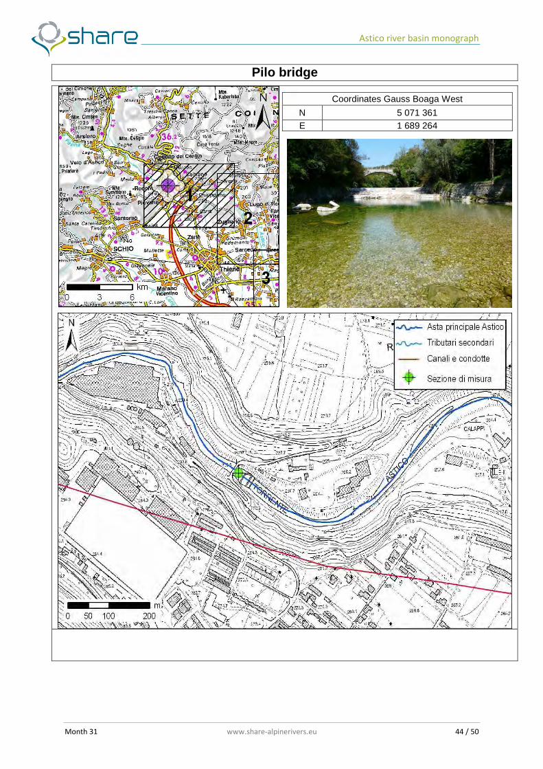
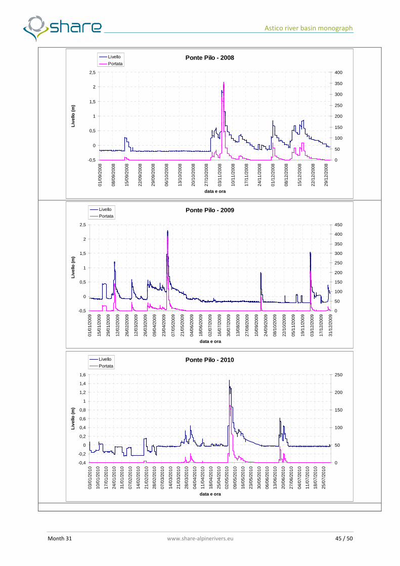
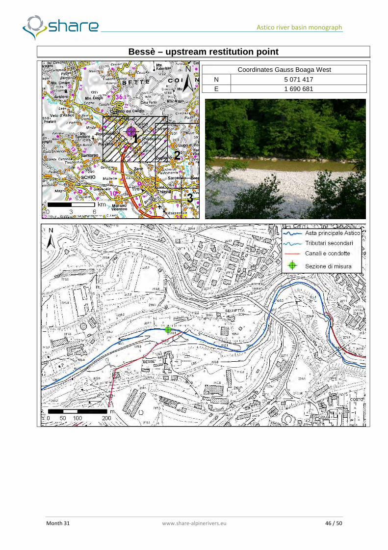
The description of the hydropower plant is deeply presented in the following data sheets (from ARPAV, 2010).
Leda dam
Coordinates Gauss Boaga West
N 5 071 773 E 1 688 218
Astico river basin monograph
Month 31 www.share-alpinerivers.eu 44 / 50
Pilo bridge
Coordinates Gauss Boaga West
N 5 071 361 E 1 689 264
Astico river basin monograph
Month 31 www.share-alpinerivers.eu 45 / 50
Ponte Pilo - 2008
-0,5
0
0,5
1
1,5
2
2,5
01/0
9/20
08
08/0
9/20
08
15/0
9/20
08
22/0
9/20
08
29/0
9/20
08
06/1
0/20
08
13/1
0/20
08
20/1
0/20
08
27/1
0/20
08
03/1
1/20
08
10/1
1/20
08
17/1
1/20
08
24/1
1/20
08
01/1
2/20
08
08/1
2/20
08
15/1
2/20
08
22/1
2/20
08
29/1
2/20
08
data e ora
Live
llo (m
)
0
50
100
150
200
250
300
350
400
Livello
Portata
Ponte Pilo - 2009
-0,5
0
0,5
1
1,5
2
2,5
01/0
1/20
09
15/0
1/20
09
29/0
1/20
09
12/0
2/20
09
26/0
2/20
09
12/0
3/20
09
26/0
3/20
09
09/0
4/20
09
23/0
4/20
09
07/0
5/20
09
21/0
5/20
09
04/0
6/20
09
18/0
6/20
09
02/0
7/20
09
16/0
7/20
09
30/0
7/20
09
13/0
8/20
09
27/0
8/20
09
10/0
9/20
09
24/0
9/20
09
08/1
0/20
09
22/1
0/20
09
05/1
1/20
09
19/1
1/20
09
03/1
2/20
09
17/1
2/20
09
31/1
2/20
09
data e ora
Live
llo (m
)
0
50
100
150
200
250
300
350
400
450
Livello
Portata
Ponte Pilo - 2010
-0,4
-0,2
0
0,2
0,4
0,6
0,8
1
1,2
1,4
1,6
03/0
1/20
10
10/0
1/20
10
17/0
1/20
10
24/0
1/20
10
31/0
1/20
10
07/0
2/20
10
14/0
2/20
10
21/0
2/20
10
28/0
2/20
10
07/0
3/20
10
14/0
3/20
10
21/0
3/20
10
28/0
3/20
10
04/0
4/20
10
11/0
4/20
10
18/0
4/20
10
25/0
4/20
10
02/0
5/20
10
09/0
5/20
10
16/0
5/20
10
23/0
5/20
10
30/0
5/20
10
06/0
6/20
10
13/0
6/20
10
20/0
6/20
10
27/0
6/20
10
04/0
7/20
10
11/0
7/20
10
18/0
7/20
10
25/0
7/20
10
data e ora
Live
llo (m
)
0
50
100
150
200
250
Livello
Portata
Astico river basin monograph
Month 31 www.share-alpinerivers.eu 46 / 50
Bessè – upstream restitution point
Coordinates Gauss Boaga West
N 5 071 417 E 1 690 681
Astico river basin monograph
Month 31 www.share-alpinerivers.eu 47 / 50
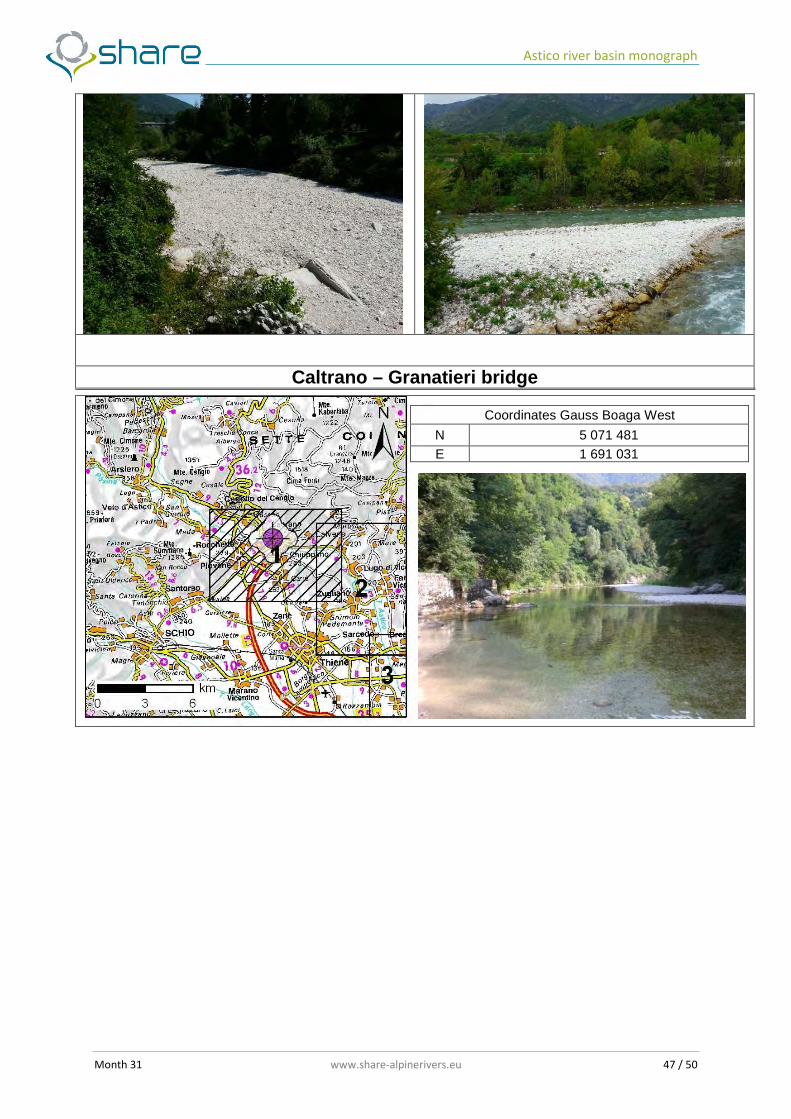
Caltrano – Granatieri bridge
Coordinates Gauss Boaga West
N 5 071 481 E 1 691 031

Astico river basin monograph
Month 31 www.share-alpinerivers.eu 48 / 50
HP plant (EUSEBIO ENERGIA)
TECHNICAL INFORMATIONS Manager Eusebio Energia Spa
Q conc Max: 10 mc/s; Mean: 5.9 mc/s
OPERA DI PRESA
MIF released 1mc/s
PRODUCTION
Power 1100 / 1880 kW
Annual energy production 12000000 kWh/yr
Astico river basin monograph
Month 31 www.share-alpinerivers.eu 49 / 50
Bessè HP station
Restitution point
Diversion canne (pipe) Astico river
Leda lake
Release point
Leda dam

Astico river basin monograph
Month 31 www.share-alpinerivers.eu 50 / 50
References
• ARPAV – DRST (2010). Misure di portata del fiume Astico tra Meda e Bolzano Vicentino. NT02 • Beta Studio s.r.l. (2011). Contratto di fiume per l'Astico-Tesina. Definizione del quadro conoscitivo.
Relazione illustrativa • Piano Territoriale di Coordinamento Provinciale della Provincia di Vicenza, approvato con D.G.R.
n. 372 del 17/02/2009. • Piano di gestione dei bacini idrografici delle Alpi Orientali - Bacino dei fiumi Brenta e Bacchiglione,
adottato il 24/02/2010 • Progetto di Piano Stralcio per l’Assetto Idrogeologico dei bacini idrografici dei fiumi ISONZO,
TAGLIAMENTO, PIAVE, BRENTA-BACCHIGLIONE Legge n. 267/98 e Legge n. 365/00 • Rinaldi et al. (2011). IDRAIM – sistema di valutazione IDRomorfologica, AnalisI e Monitoraggio dei
corsi d'acqua. Manuale tecnico – operativo per la valutazione ed il monitoraggio dello stato morfologico dei corsi d’acqua. ISPRA