sea level cci : consistency and...
TRANSCRIPT
ESA 7th Collocation meeting 4-6 October 2016, ESRIN
ESA’s Sea Level Climate Change Initiative
SeaLevelCCI:ConsistencyandStability
JF. Legeais1, G. Larnicol1, J. Benveniste2, A. Cazenave3, M. Ablain1, B. Meyssignac3, J. Johannessen13, M. Scharffenberg4, G. Timms5, P. Knudsen6, O. Andersen6, P. Cipollini7, M. Roca8, S. Rudenko9, J. Fernandes10, M.
Balmaseda11, G. Quartly12, L. Fenoglio14-15, A. Ambrozio2 , M. Restano2, M. Passaro16
1CLS, 2ESA, 3LEGOS, 4University of Hamburg, 5 CGI,6 DTU, 7 NOCS, 8IsardSAT, 9GFZ,
10 University of Porto, 11 ECMWF, 12 PML, 13NERSC, 14TUD, 15University of Bonn , 16University of Munich
ESA 7th Collocation meeting 4-6 October 2016, ESRIN
Overview
• Consistency
1. Homogeneous sea level estimations for all altimeter missions
2. Accurate estimation of global and regional sea level biases
3. Reduction of along-track long wavelength errors
• Stability
1. Improvements of altimeter standards for long-term stability
2. Errors and uncertainties fully described

ESA 7th Collocation meeting 4-6 October 2016, ESRIN
TOPEX Jason-1 Jason-2 ERS-1 ERS-2 Envisat GFO Altika Cryosat
Wet troposphere
Dry troposphere
Comb. Atm. cor.
Ocean tides
Solid Earth tide
Pole tide
Mean Sea Surface
Orbit solutions GSFC GSFC
Sea State Bias BM3 PEACHI 2D Non parametric
Ionosphere Model (NIC09)
Model (BENT+GIM)
CNES (POE-E) GFZ (Rudenko, 2015)
Filtered Altimeter ionospheric correction
CNES (POE-E)
Non parametric Non parametric
Filtered Altimeter ionospheric correction Model (GIM)
(Desai, 2015)
Reference missions Complementary missions
MSS DTU 15
FES2014 model (Lyard et Carrere, 2015)
Elastic response to tidal potential (Cartwrigh et al. 1973)
derived from ERA-interim ECMWF reanalyses (Carrere et al., 2016)
High Resolution Mog2D Model derived from ERA-interim ECMWF reanalyses (Carrere et al., 2016)
GPD+ (Fernandes et al., 2015)
1. Homogeneous sea level estimations for all altimeter missions ü Exactly the same geophysical corrections for all altimeter missions ü Altimeter corrections (sea state bias, ionosphere path delay) and orbit solutions can change from one mission to another but the consistency has been improved.
Consistency 1. Sea Level Estimation

ESA 7th Collocation meeting 4-6 October 2016, ESRIN
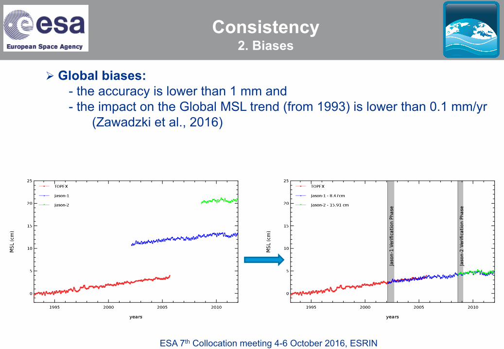
2. Accurate estimation of global and regional sea level biases
ü Global MSL time series are derived from all the missions however they are adjusted on reference missions (TOPEX/Poseidon, Jason-1 and Jason-2) ü Global and regional biases are accurately estimated thanks to verification phase of few months during which both satellites measure the same ocean:
- between TOPEX and Jason-1 in 2002 and - between Jason-1 and Jason-2 in 2008
Consistency 2. Biases
ESA 7th Collocation meeting 4-6 October 2016, ESRIN
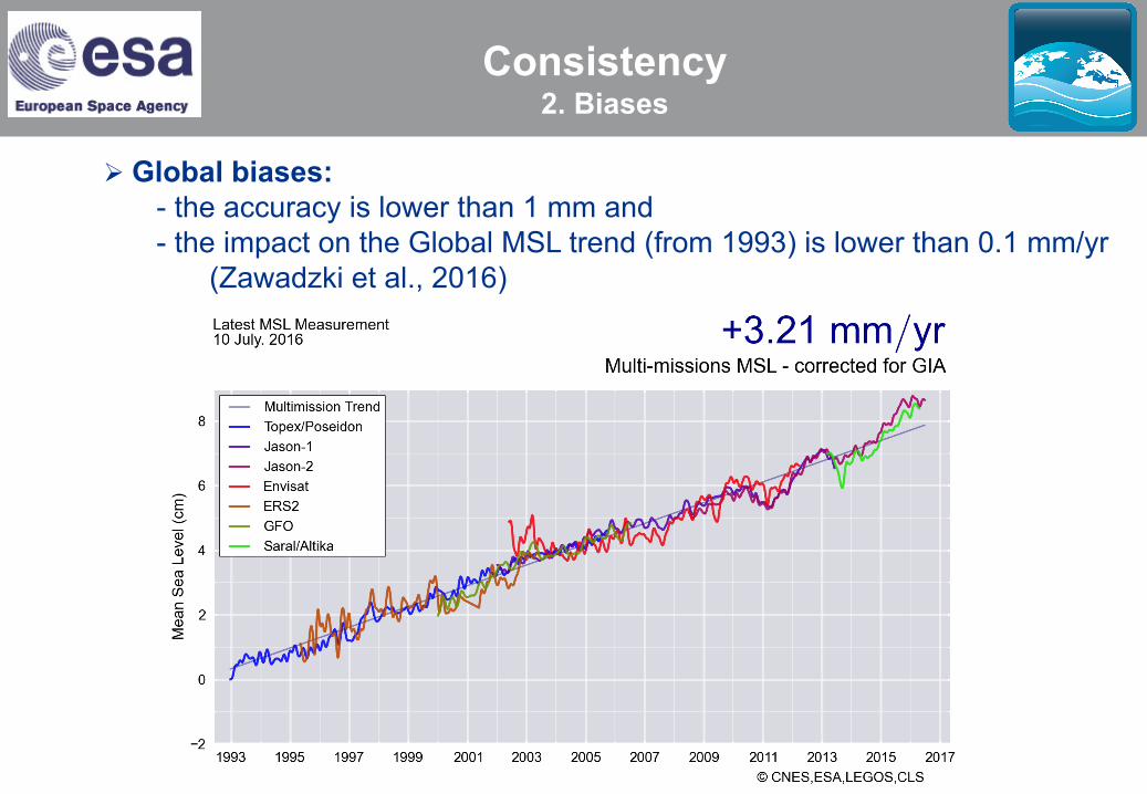
Ø Global biases: - the accuracy is lower than 1 mm and - the impact on the Global MSL trend (from 1993) is lower than 0.1 mm/yr
(Zawadzki et al., 2016)
Consistency 2. Biases
ESA 7th Collocation meeting 4-6 October 2016, ESRIN
Ø Global biases: - the accuracy is lower than 1 mm and - the impact on the Global MSL trend (from 1993) is lower than 0.1 mm/yr
(Zawadzki et al., 2016)
Consistency 2. Biases
ESA 7th Collocation meeting 4-6 October 2016, ESRIN
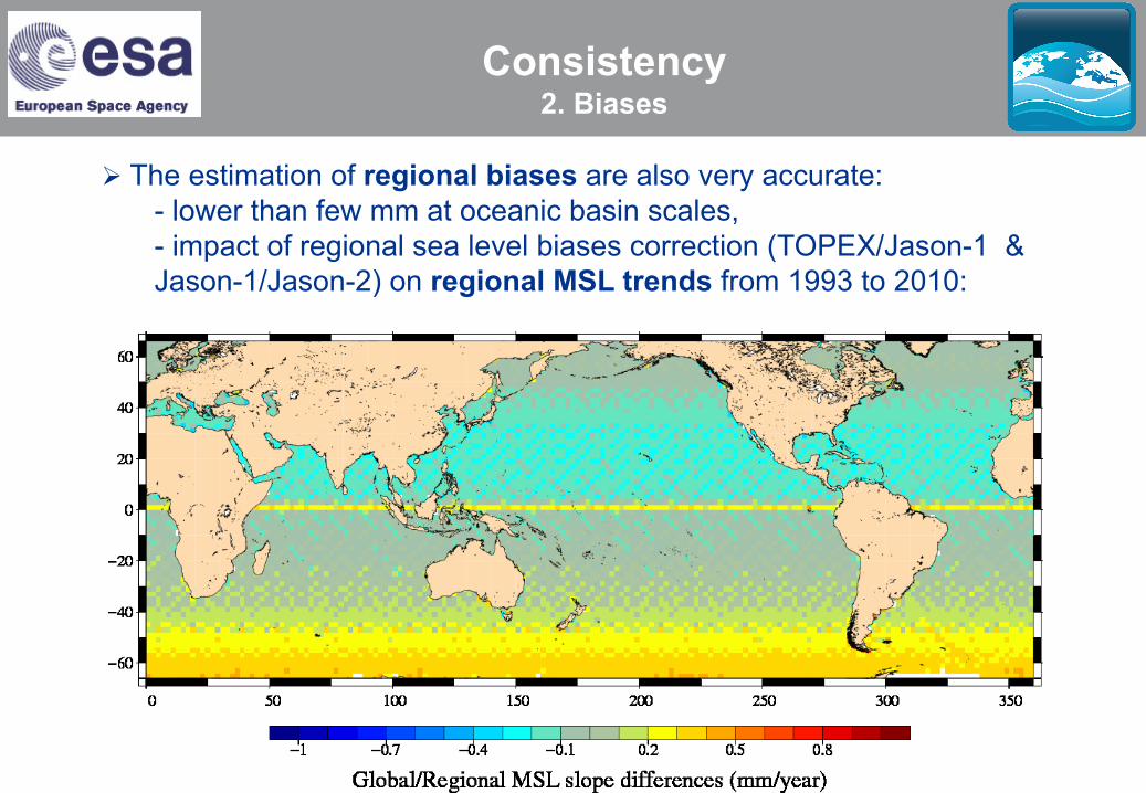
Ø The estimation of regional biases are also very accurate: - lower than few mm at oceanic basin scales, - impact of regional sea level biases correction (TOPEX/Jason-1 & Jason-1/Jason-2) on regional MSL trends from 1993 to 2010:
Consistency 2. Biases
ESA 7th Collocation meeting 4-6 October 2016, ESRIN
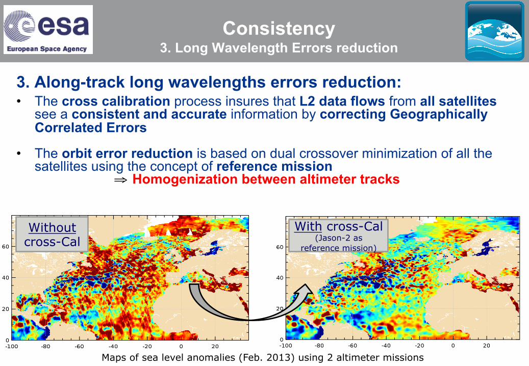
Consistency 3. Long Wavelength Errors reduction
3. Along-track long wavelengths errors reduction: • The cross calibration process insures that L2 data flows from all satellites
see a consistent and accurate information by correcting Geographically Correlated Errors
• The orbit error reduction is based on dual crossover minimization of all the satellites using the concept of reference mission
⇒ Homogenization between altimeter tracks
With cross-Cal (Jason-2 as
reference mission) Without cross-Cal
Maps of sea level anomalies (Feb. 2013) using 2 altimeter missions
ESA 7th Collocation meeting 4-6 October 2016, ESRIN
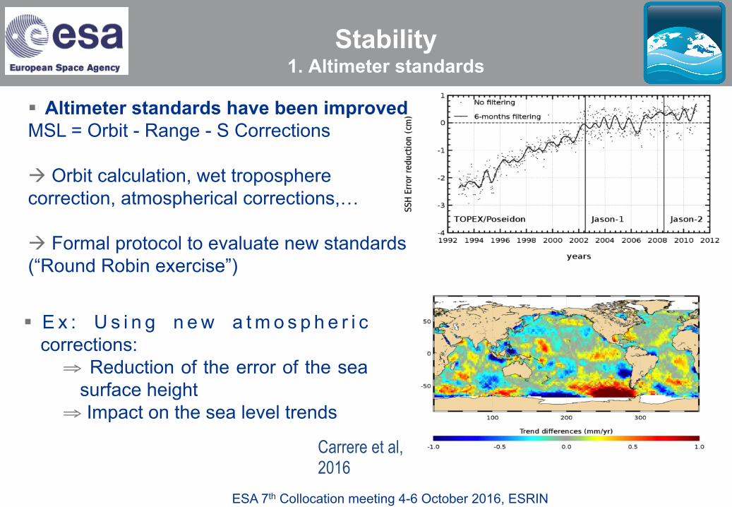
§ Altimeter standards have been improved MSL = Orbit - Range - S Corrections
à Orbit calculation, wet troposphere correction, atmospherical corrections,…
à Formal protocol to evaluate new standards (“Round Robin exercise”)
Carrere et al, 2016
§ E x : U s i n g n e w a t m o s p h e r i c corrections: ⇒ Reduction of the error of the sea
surface height ⇒ Impact on the sea level trends
Stability 1. Altimeter standards

ESA 7th Collocation meeting 4-6 October 2016, ESRIN
Couhert et al, 2015
§ Altimeter standards have been improved MSL = Orbit - Range - S Corrections
à Orbit calculation, wet troposphere correction, atmospherical corrections,…
à Formal protocol to evaluate new standards (“Round Robin exercise”)
§ Ex: Impact of using new orbit solutions
(CNES POE-D/POE-C)
Stability 1. Altimeter standards
ESA 7th Collocation meeting 4-6 October 2016, ESRIN
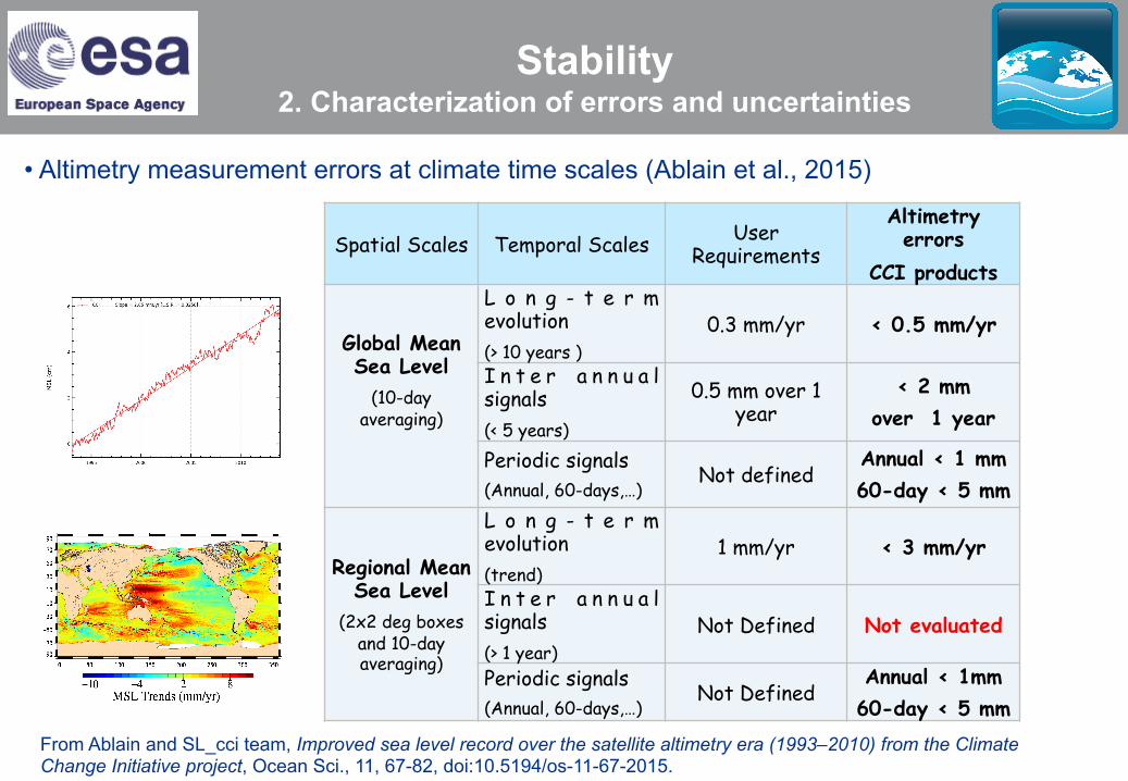
Spatial Scales Temporal Scales User Requirements
Altimetry errors
CCI products
Global Mean Sea Level
(10-day averaging)
L o n g - t e r m evolution (> 10 years )
0.3 mm/yr < 0.5 mm/yr
I n t e r a n n u a l signals (< 5 years)
0.5 mm over 1 year
< 2 mm over 1 year
Periodic signals (Annual, 60-days,…)
Not defined Annual < 1 mm 60-day < 5 mm
Regional Mean Sea Level
(2x2 deg boxes and 10-day averaging)
L o n g - t e r m evolution (trend)
1 mm/yr < 3 mm/yr
I n t e r a n n u a l signals (> 1 year)
Not Defined Not evaluated
Periodic signals (Annual, 60-days,…)
Not Defined Annual < 1mm 60-day < 5 mm
• Altimetry measurement errors at climate time scales (Ablain et al., 2015)
From Ablain and SL_cci team, Improved sea level record over the satellite altimetry era (1993–2010) from the Climate Change Initiative project, Ocean Sci., 11, 67-82, doi:10.5194/os-11-67-2015.
Stability 2. Characterization of errors and uncertainties
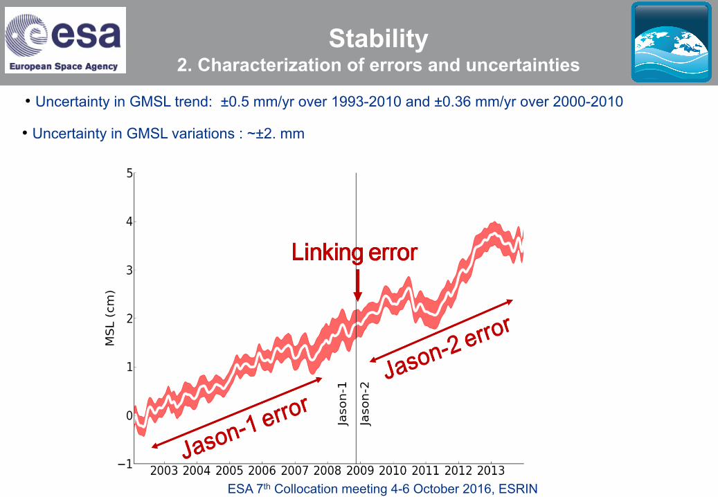
ESA 7th Collocation meeting 4-6 October 2016, ESRIN
• Uncertainty in GMSL trend: ±0.5 mm/yr over 1993-2010 and ±0.36 mm/yr over 2000-2010
• Uncertainty in GMSL variations : ~±2. mm
Stability 2. Characterization of errors and uncertainties
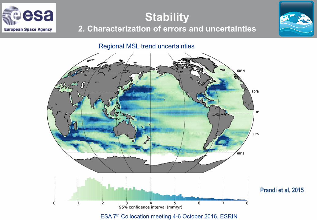
ESA 7th Collocation meeting 4-6 October 2016, ESRIN
Regional MSL trend uncertainties
Prandi et al, 2015
Stability 2. Characterization of errors and uncertainties

ESA 7th Collocation meeting 4-6 October 2016, ESRIN
• Statistically significant sea level trends: - considering altimetry errors only (on the left) and, - considering altimetry errors and natural auto covariance of the signal (on the right)
Prandi et al, 2016
Stability 2. Characterization of errors and uncertainties
ESA 7th Collocation meeting 4-6 October 2016, ESRIN
Future work
• Consistency : - Estimate global/regional bias between TOPEX-A/TOEPX-B (February 1999)
- Link Arctic Ocean and global Ocean SL_cci products
- Integrate new altimeter missions : Jason-3, Sentinel-3a, etc …
• Stability : - Continue to improve MSL calculation and processes to reach GCOS requirements :
new altimeter standards, new altimeter missions
- To better characterize MSL uncertainties to validate the MSL content and to better know sea-level rise components, at global, regional & inter-annual scales and for each MSL estimation
- To continue to improve MSL stability in non-optimal areas for altimeters: coastal areas, Arctic Ocean