aerosol and cloud related products by esa’s aeolus mission
TRANSCRIPT

ICAP 2012, ESRIN, 15 May 2012
Aerosol and cloud related products by ESA’s Aeolus mission
Stefano Casadio1, Anne Grete Straume2, Christophe Caspar2
1IDEAS/SERCO, 2ESA
ICAP 2012, ESRIN, 15 May 2012
Overview
1. Motivation for ESA’s wind lidar mission
2. The Aeolus Doppler Wind Lidar Mission
a. Aeolus aerosol and cloud monitoring capabilities
b. Aeolus vs. Calipso/ATLID
3. Cal/Val
4. Conclusions
What is ADM-Aeolus?
ICAP 2012, ESRIN, 15 May 2012
Atmospheric Dynamics Mission - AeolusIt’s a Doppler Lidar Wind mission ...
... providing valuable info on aerosols and clouds!
Launch date: spring 2014
ICAP 2012, ESRIN, 15 May 2012
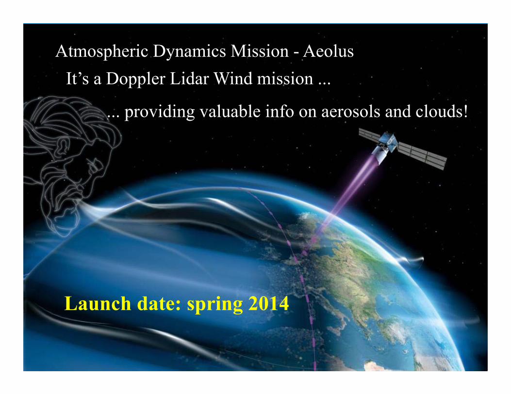
Global Observing System (GOS) wind information
•Radiosonde and pilot soundings –left (BUT NH continents dominate)
•Aircraft data (BUT NH densely populated areas dominate)
•Satellite soundings of temperature and humidity from Polar orbiting satellites (BUT indirect measure of large-scale phenomenon wind outside the tropics through geostrophic balance)
•Atmospheric motion vectors (BUT only in the presence of clouds)
Why launch a space-based DWL?
1. There is a need for homogeneous global direct measurements of wind profiles, in order to improve the analysis of the atmospheric state for NWP and Climate modelling
2. Aeolus shall demonstrate the capabilities of space-based HSR Doppler Wind LIDARs (DWLs) for global wind profiling and their potential for operational use
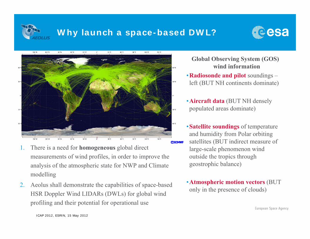
ADM-Aeolus orbit characteristics
ICAP 2012, ESRIN, 15 May 2012
Why 6pm crossing time?1) Solar panels almost always illuminated (power for the laser)
Level 2A ATBD
2) Largely reduced thermal stress (stability of environment)
ICAP 2012, ESRIN, 15 May 2012
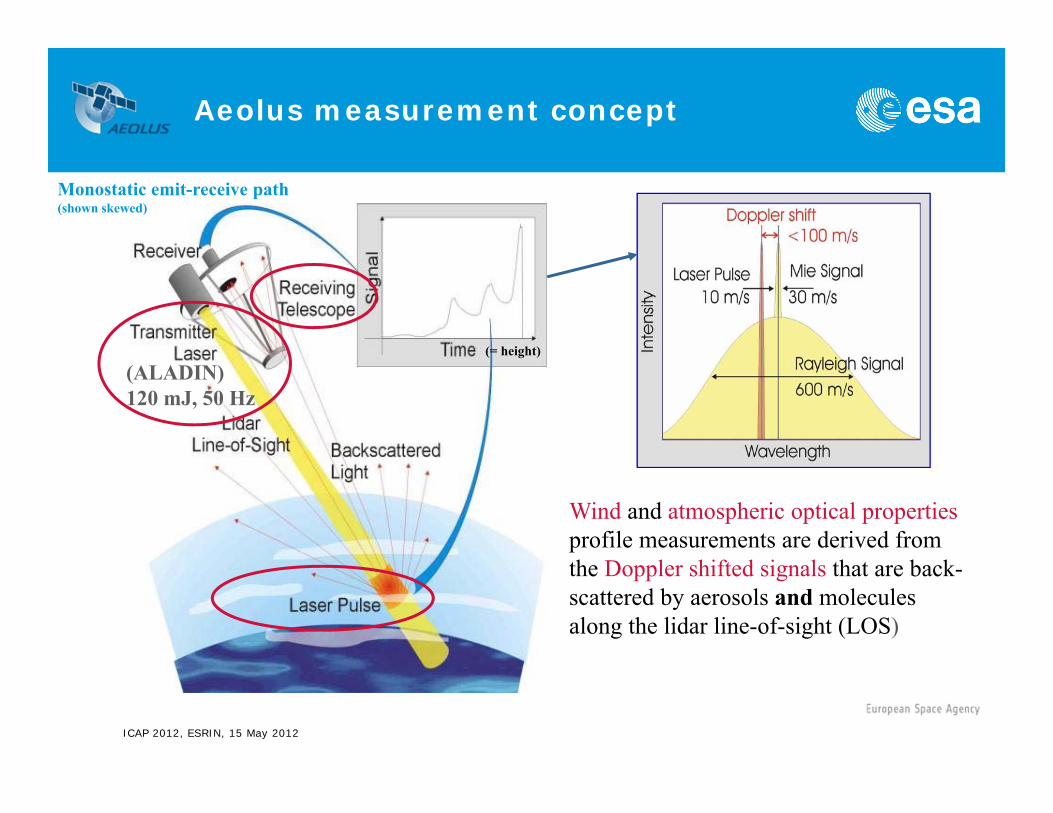
(ALADIN)120 mJ, 50 Hz
(= height)
Wind and atmospheric optical propertiesprofile measurements are derived from the Doppler shifted signals that are back-scattered by aerosols and molecules along the lidar line-of-sight (LOS)
Monostatic emit-receive path(shown skewed)
Aeolus measurement concept
ICAP 2012, ESRIN, 15 May 2012
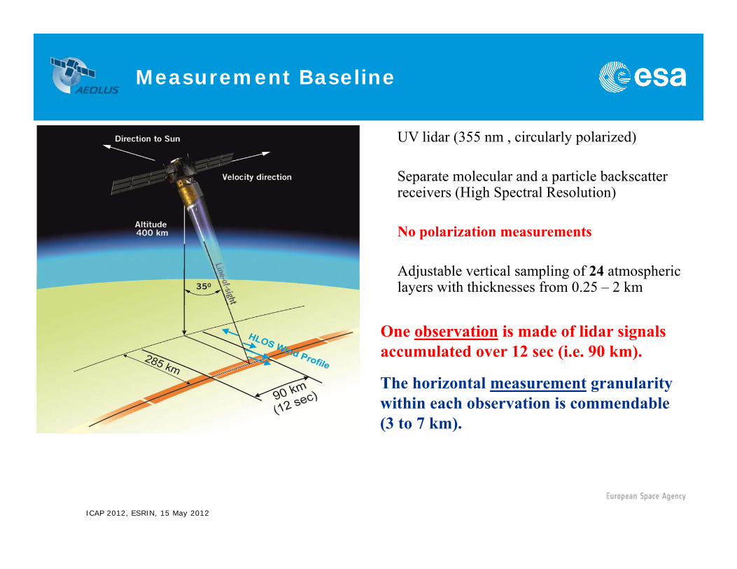
UV lidar (355 nm , circularly polarized)
Separate molecular and a particle backscatter receivers (High Spectral Resolution)
No polarization measurements
Adjustable vertical sampling of 24 atmospheric layers with thicknesses from 0.25 – 2 km
Measurement Baseline
The horizontal measurement granularity within each observation is commendable(3 to 7 km).
One observation is made of lidar signals accumulated over 12 sec (i.e. 90 km).
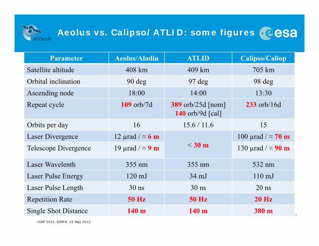
Aeolus vs. Calipso/ATLID: some figures
ICAP 2012, ESRIN, 15 May 2012
Parameter Aeolus/Aladin ATLID Calipso/CaliopSatellite altitude 408 km 409 km 705 kmOrbital inclination 90 deg 97 deg 98 degAscending node 18:00 14:00 13:30Repeat cycle 109 orb/7d 389 orb/25d [nom]
140 orb/9d [cal]233 orb/16d
Orbits per day 16 15.6 / 11.6 15Laser Divergence 12 µrad / ≈ 6 m
< 30 m100 µrad / ≈ 70 m
Telescope Divergence 19 µrad / ≈ 9 m 130 µrad / ≈ 90 m
Laser Wavelenth 355 nm 355 nm 532 nmLaser Pulse Energy 120 mJ 34 mJ 110 mJLaser Pulse Length 30 ns 30 ns 20 nsRepetition Rate 50 Hz 50 Hz 20 HzSingle Shot Distance 140 m 140 m 380 m
ICAP 2012, ESRIN, 15 May 2012
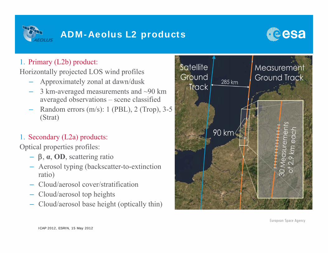
1. Primary (L2b) product:Horizontally projected LOS wind profiles
– Approximately zonal at dawn/dusk– 3 km-averaged measurements and ~90 km
averaged observations – scene classified– Random errors (m/s): 1 (PBL), 2 (Trop), 3-5
(Strat)
1. Secondary (L2a) products:Optical properties profiles:
– , α, OD, scattering ratio– Aerosol typing (backscatter-to-extinction
ratio)– Cloud/aerosol cover/stratification– Cloud/aerosol top heights– Cloud/aerosol base height (optically thin)
ADM-Aeolus L2 products
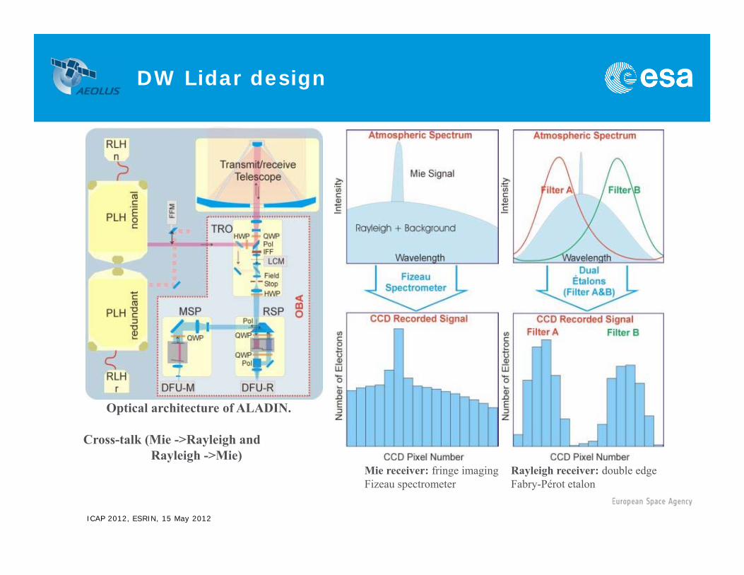
DW Lidar design
ICAP 2012, ESRIN, 15 May 2012
Optical architecture of ALADIN.
Cross-talk (Mie ->Rayleigh andRayleigh ->Mie)
Rayleigh receiver: double edgeFabry-Pérot etalon
Mie receiver: fringe imagingFizeau spectrometer

ICAP 2012, ESRIN, 15 May 2012
zR
zzzCzCKzS
zRzzzCzCKzS
aermolaermolMieMie
aermolaermolRayRay
2
22
43
2
22
21
For each observation, ADM provides two signals, one Rayleigh, one Mie, related to the optical parameters of the atmosphere via the equations:
where C1, C2, C3, C4, Kray and Kmie are known calibration constants (C1C2; C3«C4).
In principle, it is possible to determine αaer(z) and βaer(z) from the equations above.
In practise, difficulties are encountered due to:• The lidar cannot distinguish absorption and scattering extinction• Large thickness of the height bin (vertical inhomogeneity give ambiguous
results when solving the lidar equation)• Dependence on a priori temperature and pressure information• Only way to discriminate aerosol versus cloud particles: use β/α
Aeolus - HSRL
(by A. Dabas, MeteoFrance)
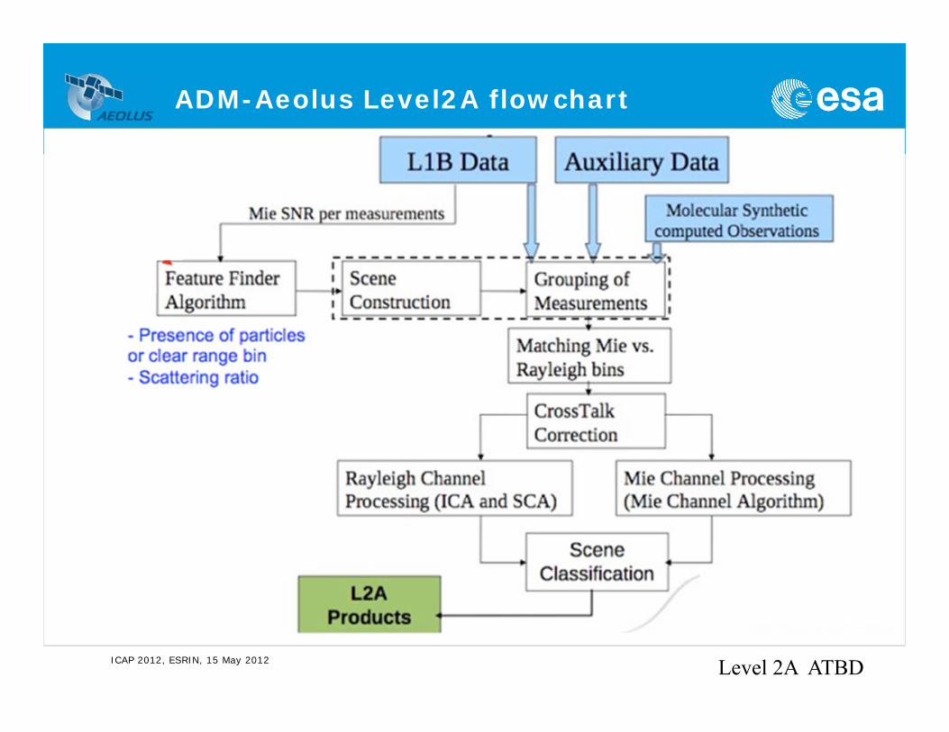
ADM-Aeolus Level2A flowchart
ICAP 2012, ESRIN, 15 May 2012 Level 2A ATBD
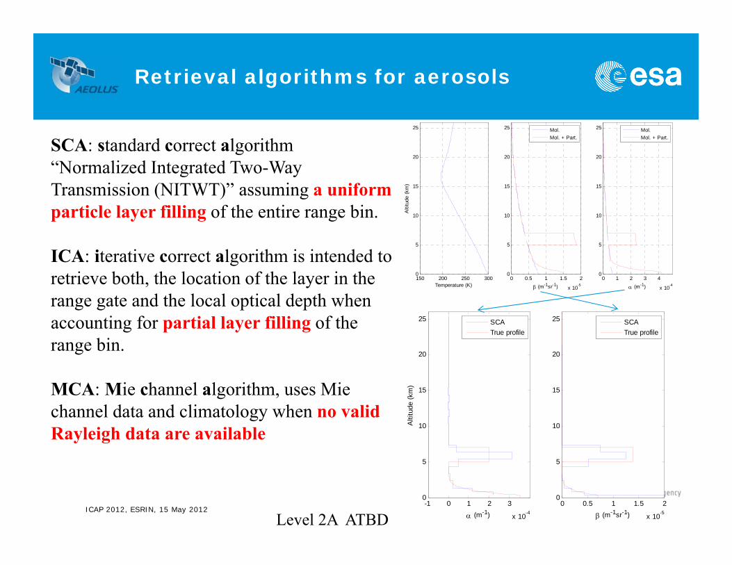
Retrieval algorithms for aerosols
ICAP 2012, ESRIN, 15 May 2012
SCA: standard correct algorithm “Normalized Integrated Two-Way Transmission (NITWT)” assuming a uniform particle layer filling of the entire range bin.
ICA: iterative correct algorithm is intended to retrieve both, the location of the layer in the range gate and the local optical depth when accounting for partial layer filling of the range bin.
MCA: Mie channel algorithm, uses Mie channel data and climatology when no valid Rayleigh data are available
150 200 250 3000
5
10
15
20
25
Temperature (K)
Alti
tude
(km
)
0 0.5 1 1.5 2
x 10-5
0
5
10
15
20
25
(m-1sr-1)0 1 2 3 4
x 10-4
0
5
10
15
20
25
(m-1)
Mol.Mol. + Part.
Mol.Mol. + Part.
-1 0 1 2 3
x 10-4
0
5
10
15
20
25
(m-1)
Alti
tude
(km
)
SCATrue profile
0 0.5 1 1.5 2
x 10-5
0
5
10
15
20
25
(m-1sr-1)
SCATrue profile
Level 2A ATBD

Aeolus vs. Calipso/ATLID: vertical resolution
ICAP 2012, ESRIN, 15 May 2012
Layer (km) Resolution in km
30 – 40 0.3020 – 30 0.188 – 20 0.060 – 8 0.03-2 – 0 0.30
Calipso
ATLID: 0.1 km
Finer grid (0.5 km) for Mie channel below 3 km

Aeolus: Why only 24 range bins?
ICAP 2012, ESRIN, 15 May 2012 ADM-Aeolus Science Report
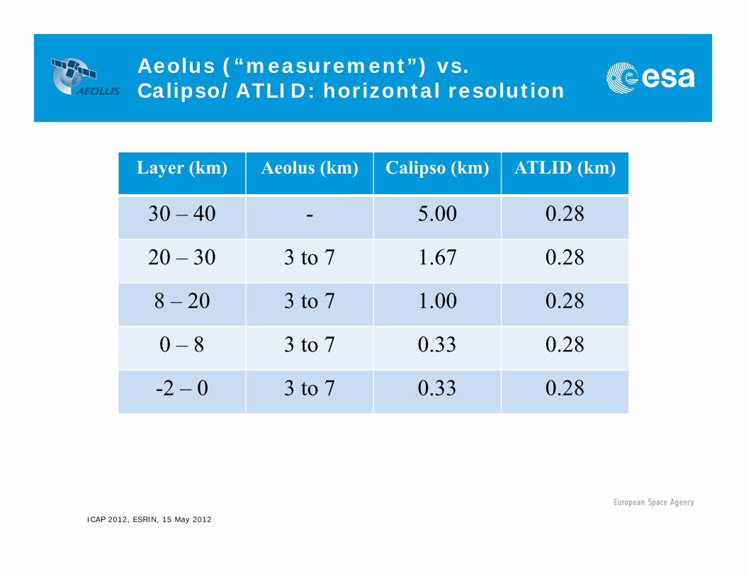
Aeolus (“measurement”) vs. Calipso/ATLID: horizontal resolution
ICAP 2012, ESRIN, 15 May 2012
Layer (km) Aeolus (km) Calipso (km) ATLID (km)
30 – 40 - 5.00 0.28
20 – 30 3 to 7 1.67 0.28
8 – 20 3 to 7 1.00 0.28
0 – 8 3 to 7 0.33 0.28
-2 – 0 3 to 7 0.33 0.28
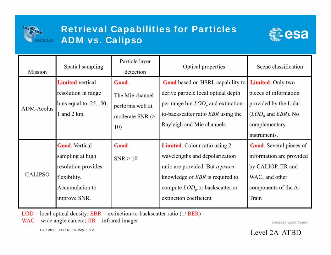
Retrieval Capabilities for ParticlesADM vs. Calipso
ICAP 2012, ESRIN, 15 May 2012
MissionSpatial sampling
Particle layer
detection Optical properties Scene classification
ADM-Aeolus
Limited vertical
resolution in range
bins equal to .25, .50,
1 and 2 km.
Good.
The Mie channel
performs well at
moderate SNR (>
10)
Good based on HSRL capability to
derive particle local optical depth
per range bin LODp and extinction-
to-backscatter ratio EBR using the
Rayleigh and Mie channels
Limited. Only two
pieces of information
provided by the Lidar
(LODp and EBR). No
complementary
instruments.
CALIPSO
Good. Vertical
sampling at high
resolution provides
flexibility.
Accumulation to
improve SNR.
Good
SNR > 10
Limited. Colour ratio using 2
wavelengths and depolarization
ratio are provided. But a priori
knowledge of EBR is required to
compute LODp.or backscatter or
extinction coefficient
Good. Several pieces of
information are provided
by CALIOP, IIR and
WAC, and other
components of the A-
Train
LOD = local optical density; EBR = extinction-to-backscatter ratio (1/ BER)WAC = wide angle camera; IIR = infrared imager
Level 2A ATBD

Some of the ADM Cal/Val tasks
1. Assessment, characterization of radiometric performance and stability
2. Validation of geo-location information
3. Recommendations for enhancements of algorithm and observational settings
4. Systematic validation of algorithms from L1A to L1B and L2A and L1B to L2B
5. Validation of stability of instrument calibration
ICAP 2012, ESRIN, 15 May 2012
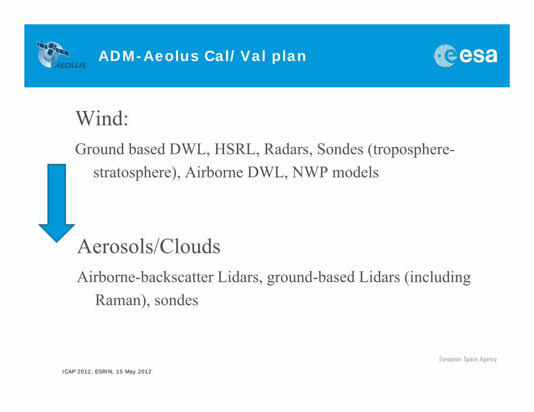
ADM-Aeolus Cal/Val plan
Wind:Ground based DWL, HSRL, Radars, Sondes (troposphere-
stratosphere), Airborne DWL, NWP models
ICAP 2012, ESRIN, 15 May 2012
Aerosols/CloudsAirborne-backscatter Lidars, ground-based Lidars (including
Raman), sondes

ADM-Aeolus validation campaigns
ICAP 2012, ESRIN, 15 May 2012
Campaigns:a. 2 ground-based (2006, 2007) and 3 airborne (2007,
2008 and 2009)b. So far, on the order of 100 recommendations for the
Aeolus mission (instrument and algorithm development and testing)
c. Phase E1 (commissioning, ESTEC) and phase E2 (operation, ESRIN) campaigns will be defined soon
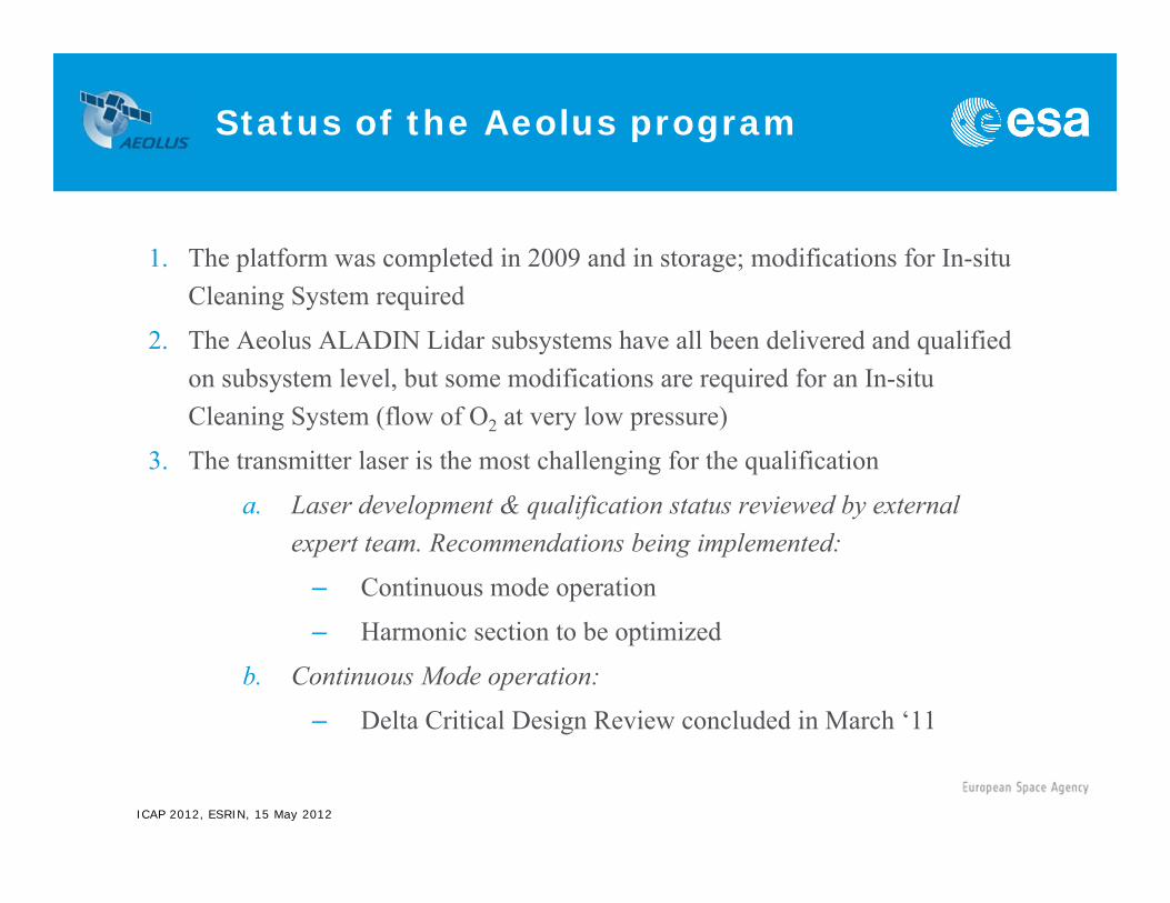
Status of the Aeolus program
ICAP 2012, ESRIN, 15 May 2012
1. The platform was completed in 2009 and in storage; modifications for In-situ Cleaning System required
2. The Aeolus ALADIN Lidar subsystems have all been delivered and qualified on subsystem level, but some modifications are required for an In-situ Cleaning System (flow of O2 at very low pressure)
3. The transmitter laser is the most challenging for the qualification
a. Laser development & qualification status reviewed by external expert team. Recommendations being implemented:
– Continuous mode operation
– Harmonic section to be optimized
b. Continuous Mode operation:
– Delta Critical Design Review concluded in March ‘11

Conclusions
ICAP 2012, ESRIN, 15 May 2012
1. Aeolus wind lidar mission will deliver atmospheric optical properties measurements as secondary products (L2a)
2. The Aeolus L2a products will be made available to users off-line (now every 12 hours) but could in the future become available every 4 hours or more often
3. Aeolus L1b products will be available to users NRT and could be further processed locally
4. Launch scheduled for spring 2014
ICAP 2012, ESRIN, 15 May 2012
Thank you for your attention!
ADM-Aeolus
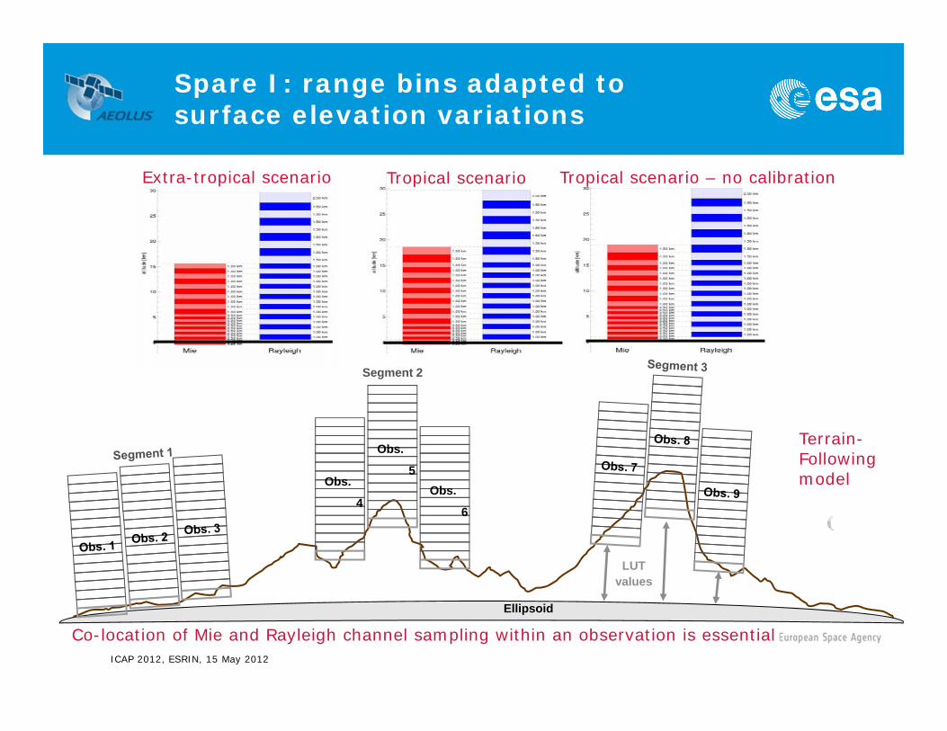
Spare I: range bins adapted to surface elevation variations
ICAP 2012, ESRIN, 15 May 2012
Extra-tropical scenario Tropical scenario Tropical scenario – no calibration
Co-location of Mie and Rayleigh channel sampling within an observation is essential
Terrain-Followingmodel
Segment 2
Ellipsoid
Obs.
6
Obs.
5Obs.
4
LUT values
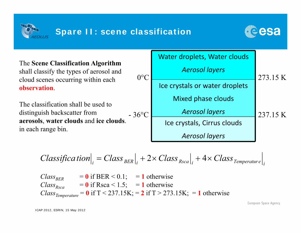
Spare II: scene classification
ICAP 2012, ESRIN, 15 May 2012
- 36°C
0°C
Ice crystals, Cirrus clouds
Aerosol layers
Ice crystals or water droplets
Mixed phase clouds
Aerosol layers
Water droplets, Water clouds
Aerosol layers
237.15 K
273.15 K
ieTemperaturiRscaiBERiClassClassClasstionClassifica 42
ClassBER = 0 if BER < 0.1; = 1 otherwiseClassRsca = 0 if Rsca < 1.5; = 1 otherwiseClassTemperature = 0 if T < 237.15K; = 2 if T > 273.15K; = 1 otherwise
The Scene Classification Algorithm shall classify the types of aerosol and cloud scenes occurring within each observation.
The classification shall be used to distinguish backscatter fromaerosols, water clouds and ice clouds.in each range bin.
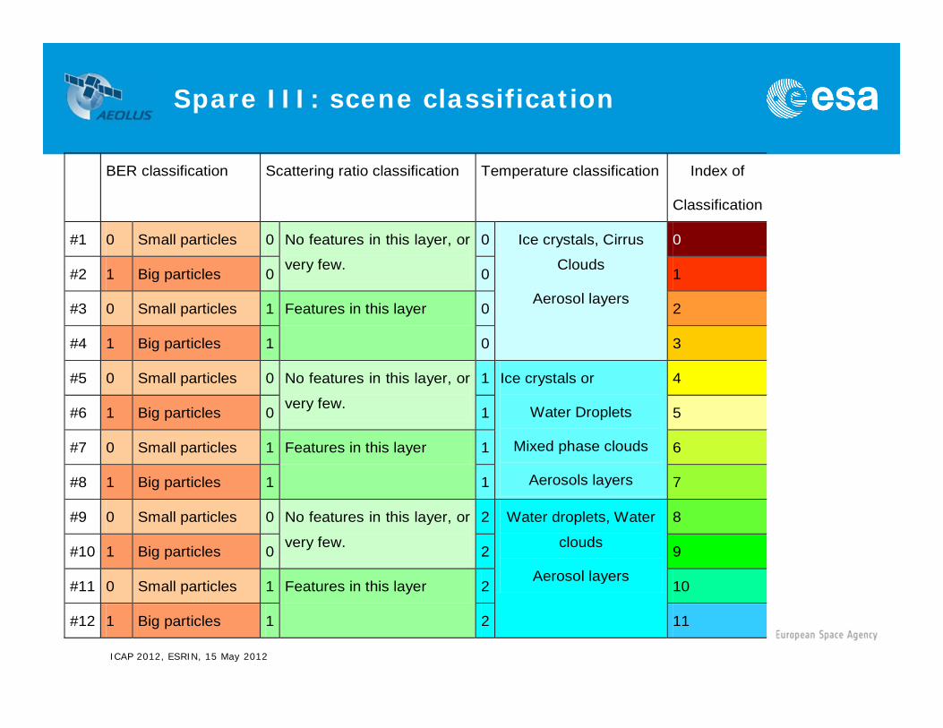
Spare III: scene classification
ICAP 2012, ESRIN, 15 May 2012
BER classification Scattering ratio classification Temperature classification Index of
Classification
#1 0 Small particles 0 No features in this layer, or
very few.
0 Ice crystals, Cirrus
Clouds
Aerosol layers
0
#2 1 Big particles 0 0 1
#3 0 Small particles 1 Features in this layer 0 2
#4 1 Big particles 1 0 3
#5 0 Small particles 0 No features in this layer, or
very few.
1 Ice crystals or
Water Droplets
Mixed phase clouds
Aerosols layers
4
#6 1 Big particles 0 1 5
#7 0 Small particles 1 Features in this layer 1 6
#8 1 Big particles 1 1 7
#9 0 Small particles 0 No features in this layer, or
very few.
2 Water droplets, Water
clouds
Aerosol layers
8
#10 1 Big particles 0 2 9
#11 0 Small particles 1 Features in this layer 2 10
#12 1 Big particles 1 2 11
Spare IV: spectral resolution
ICAP 2012, ESRIN, 15 May 2012
•The two FP band-passes FP-A and FP-B have a FWHM = 0.7 pm (or 1.67 GHz) and are separated by 2.3 pm (or 5.47 GHz).
•The free spectral range (FSR) of the Fizeau interferometer is equal to 0.92 pm but only a fraction of it is imaged onto the detector so the useful spectral range is USR = 0.63 pm or 1500 MHz.
•The FWHM of the Fizeau interferometer transfer function is 0.06 pm or about 143 MHz. Each channel has an equivalent spectral width of 93.75 MHz or 17 m/s.

Spare V: Mie and Rayleigh signals
ICAP 2012, ESRIN, 15 May 2012 Level 2A ATBD