scotch corner landfill, derryarrily, … · habitat assessment was carried out at the sites...
TRANSCRIPT

SCOTCH CORNER LANDFILL, DERRYARRILY, COUNTY
MONAGHAN
MONITORING OF STREAM/ RIVER BIOLOGICAL WATER QUALITY
May 2016
REPORT PREPARED FOR MONAGHAN COUNTY COUNCIL
by
Bill Quirke BSc, MSc, MCIEEM & Helena Twomey BA(Mod), PhD
Conservation Services, Tullaha, Glenflesk, Killarney, Co. Kerry Tel/Fax 064 6630130 e-mail [email protected]
For
insp
ectio
n pur
pose
s only
.
Conse
nt of
copy
right
owne
r req
uired
for a
ny ot
her u
se.
EPA Export 07-09-2016:01:26:58

2
Client: Monaghan County Council
Project Biological monitoring of water quality in the vicinity of Scotch Corner Landfill, Derryarrily, Co. Monaghan
Report No: 16113/F
Date 15/06/16
Status Final
Prepared by Helena Twomey BA(Mod) , PhD
Reviewed by Bill Quirke BSc, MSc, MCIEEM
For
insp
ectio
n pur
pose
s only
.
Conse
nt of
copy
right
owne
r req
uired
for a
ny ot
her u
se.
EPA Export 07-09-2016:01:26:58

3
CONTENTS
1 INTRODUCTION ........................................................................................ 4
2 METHODOLOGY ........................................................................................ 5
2.1 SITE SELECTION................................................................................ 5 2.2 HABITAT ASSESSMENT .................................................................... 5 2.3 INVERTEBRATE SAMPLING AND WATER QUALITY ASSESSMENT ............................................................................................................. 6
3 RESULTS ................................................................................................... 8
3.1 SITE S8 ............................................................................................... 8
3.2 SITE S7 ............................................................................................... 9 3.3 SITE 0155 .......................................................................................... 10 3.4 WATER QUALITY ASSESSMENT DATA 1997 – 2016 ..................... 11
4 CONCLUSIONS ........................................................................................ 12 5 REFERENCES ......................................................................................... 13
APPENDIX 1 HABITAT ASSESSMENT AT SAMPLING SITES
For
insp
ectio
n pur
pose
s only
.
Conse
nt of
copy
right
owne
r req
uired
for a
ny ot
her u
se.
EPA Export 07-09-2016:01:26:58

4
1. INTRODUCTION
Conservation Services, Ecological & Environmental Consultants have been
commissioned by Monaghan County Council to carry out biological sampling
and water quality assessment at two sites on the stream/drain adjacent to the
landfill at Scotch Corner, Derryarrily, County Monaghan, upstream and
downstream of the landfill, and at EPA Site 6/F/01/0155. Sampling was carried
out on 25 May 2016.
For
insp
ectio
n pur
pose
s only
.
Conse
nt of
copy
right
owne
r req
uired
for a
ny ot
her u
se.
EPA Export 07-09-2016:01:26:58

5
2. METHODOLOGY
2.1. SITE SELECTION
Sampling was carried out at three sites specified by Monaghan County Council
(see Map 1). These sites were most recently assessed by Conservation
Services in June 2015 (Conservation Services, 2015).
Site locations were recorded using GPS.
2.2. HABITAT ASSESSMENT
Habitat assessment was carried out at the sites selected for invertebrate/water
quality assessment. The site was assessed in terms of:
Stream width and depth
Substrate type, listing substrate fractions in order of dominance, i.e. large
rocks, cobble, gravel, sand, mud etc.
Flow type, listing percentage of riffle, glide and pool in the sampling area
Instream vegetation, listing plant species occurring and their percentage
coverage of the stream bottom at the sampling site
Dominant bankside vegetation, listing the main species overhanging the
stream
Estimated summer cover by bankside vegetation, giving percentage shade
of the sampling site
For
insp
ectio
n pur
pose
s only
.
Conse
nt of
copy
right
owne
r req
uired
for a
ny ot
her u
se.
EPA Export 07-09-2016:01:26:58
6
Rating of the site as habitat for trout adult, nursery and spawning on a scale
of Poor/Fair/Good/Very Good/Excellent. This rating assesses the physical
suitability of the habitat; the presence/absence/density of salmonids at the
site will also depend on present and historical water quality and accessibility
of the site to fish.
2.3. INVERTEBRATE SAMPLING AND WATER QUALITY
ASSESSMENT
A five-minute kick and stone wash sample was taken at each sampling site.
Each sample was retained in a large plastic bag at the sampling site. Sample
processing and preservation was carried out under laboratory conditions within
24 hours of sampling. Mud was removed from each sample by sieving under
running water through a 500μ sieve. Sieved samples were then live sorted for
30 minutes in a white plastic sorting tray under a bench lamp (ISO 5667-3:1994)
and if necessary using a magnifying lens. Macroinvertebrates were stored in
70% alcohol. Preserved invertebrates were identified to the level required for
the EPA Q-rating method (McGarrigle et al, 2002) using high-power and low-
power binocular microscopes when necessary. The preserved samples were
archived for future examination or verification. Based on the relative abundance
of indicator species, a biotic index (Q-rating) was determined for each site in
accordance with the biological assessment procedure used by the
Environmental Protection Agency (McGarrigle et al, 2002) and more detailed
unpublished methodology (McGarrigle, Clabby and Lucey pers. comm.)
For
insp
ectio
n pur
pose
s only
.
Conse
nt of
copy
right
owne
r req
uired
for a
ny ot
her u
se.
EPA Export 07-09-2016:01:26:58

7
Biotic Index
Water Framework Directive Ecological Status
Quality Status
Q5 High
Unpolluted Waters Q4-5 High
Q4 Good
Q3-4 Moderate Slightly Polluted Waters
Q3 Poor Moderately Polluted Waters
Q2-3 Poor
Q2 Bad Seriously Polluted Waters
Q1-2 Bad
Q1 Bad
For
insp
ectio
n pur
pose
s only
.
Conse
nt of
copy
right
owne
r req
uired
for a
ny ot
her u
se.
EPA Export 07-09-2016:01:26:58

MAP 1 LOCATION OF BIOLOGICAL ASSESSMENT SITES Locations shown are approximate; for exact locations, see Grid References in text
SITE 0155
LANDFILL SITE
SITE S7
SITE S8
For
insp
ectio
n pur
pose
s only
.
Conse
nt of
copy
right
owne
r req
uired
for a
ny ot
her u
se.
EPA Export 07-09-2016:01:26:58

8
3. RESULTS
Habitat at each site is described in Appendix 1.
3.1. SITE S8
The invertebrate community continues to merit a Q-rating of Q2-3, indicating
moderately polluted conditions.
INDICATOR GROUP TAXON 2016
Group A - Pollution Sensitive None recorded
Group B - Less Pollution Sensitive
Limnephilidae 2
Group C - Pollution Tolerant Gammarus pulex c.500
Chironomidae (ex. Chironomus ) 3
Limoniidae 2
Pediciidae 6
Hydraena sp. 1
Group D - Very Pollution Tolerant
Haemopis sanguisuga 1
Asellus aquaticus 11
Group E - Most Pollution Tolerant
Tubificidae 5
Not assigned to indicator group
Lumbricidae 1
Naididae 1
For
insp
ectio
n pur
pose
s only
.
Conse
nt of
copy
right
owne
r req
uired
for a
ny ot
her u
se.
EPA Export 07-09-2016:01:26:58

9
3.2. SITE S7
The invertebrate community at this site continues to merit a Q-rating of Q2-3,
indicating moderately polluted conditions.
INDICATOR GROUP TAXON 2016
Group A - Pollution Sensitive None recorded
Group B - Less Pollution Sensitive
Limnephilidae 1
Group C - Pollution Tolerant Gammarus pulex c.500
Chironomidae (ex. Chironomus ) 1
Group D - Very Pollution Tolerant
Helobdella stagnalis 6
Asellus aquaticus 15
Group E - Most Pollution Tolerant
None recorded
Not assigned to indicator group
Lumbriculidae 1
For
insp
ectio
n pur
pose
s only
.
Conse
nt of
copy
right
owne
r req
uired
for a
ny ot
her u
se.
EPA Export 07-09-2016:01:26:58
10
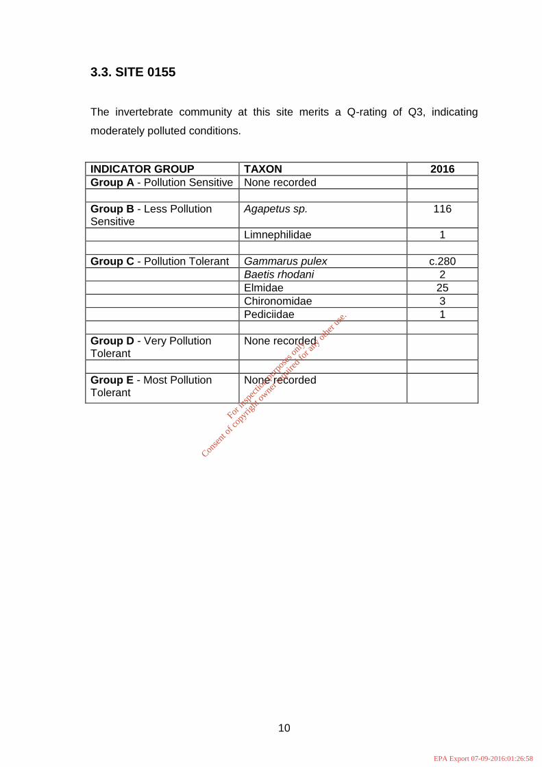
3.3. SITE 0155
The invertebrate community at this site merits a Q-rating of Q3, indicating
moderately polluted conditions.
INDICATOR GROUP TAXON 2016
Group A - Pollution Sensitive None recorded
Group B - Less Pollution Sensitive
Agapetus sp. 116
Limnephilidae 1
Group C - Pollution Tolerant Gammarus pulex c.280
Baetis rhodani 2
Elmidae 25
Chironomidae 3
Pediciidae 1
Group D - Very Pollution Tolerant
None recorded
Group E - Most Pollution Tolerant
None recorded
For
insp
ectio
n pur
pose
s only
.
Conse
nt of
copy
right
owne
r req
uired
for a
ny ot
her u
se.
EPA Export 07-09-2016:01:26:58

11
3.4. WATER QUALITY ASSESSMENT DATA 1997 – 2016
S8 S7 0155 0180
EPA 1997 - - 2-3 3
CS 1998 - - 3 -
EPA 2000 - - 2-3 3
CS 2002 - 1/0 - -
CS May 2003 - 2-3 3 3
EPA Aug 2003 - - 2-3 3
CS 2005 - 2-3 3 3-4
CS 2006 - 2-3 3 3-4
CS 2007 - 2 3 3
CS 2008 - 2-3 3 3-4
CS 2009 - 2-3 3 3-4
CS 2010 2-3 2-3 3 -
CS 2011 2 2-3 3 -
CS 2012 2 2-3 3 -
CS 2013 2-3 2-3 3 -
CS 2014 2-3 2-3 3 -
CS 2015 2-3 2-3 3 -
CS 2016 2-3 2-3 3 -
For
insp
ectio
n pur
pose
s only
.
Conse
nt of
copy
right
owne
r req
uired
for a
ny ot
her u
se.
EPA Export 07-09-2016:01:26:58

MAP 2 Q-RATINGS AT BIOLOGICAL ASSESSMENT SITES Locations shown are approximate; for exact locations, see Grid References in text
3
LANDFILL SITE
2-3
2-3
For
insp
ectio
n pur
pose
s only
.
Conse
nt of
copy
right
owne
r req
uired
for a
ny ot
her u
se.
EPA Export 07-09-2016:01:26:58

12
4. CONCLUSIONS
The drain which flows adjacent to the landfill is classified as moderately polluted
(Q2-3) at Site S8 upstream of the landfill, as in the previous three years. Site
S7 downstream of the landfill remains classified as moderately polluted Q2-3 as
in the previous eight years. Site 0155, which is c.3km downstream of the landfill,
is moderately polluted (Q3) as in the previous eleven years.
The results of the biological assessment do not indicate any significant impact
from the landfill on the water quality of the stream.
Signed on behalf of Conservation Services
Helena Twomey BA(Mod.) PhD
15 June 2016
For
insp
ectio
n pur
pose
s only
.
Conse
nt of
copy
right
owne
r req
uired
for a
ny ot
her u
se.
EPA Export 07-09-2016:01:26:58
13
5. REFERENCES
Conservation Services (2015) Biological Monitoring of Surface Water Quality
in the Vicinity of Scotch Corner Landfill, Derryarrily, County Monaghan. Report
carried out for Monaghan County Council.
McGarrigle, M.L. et al (2002) Water Quality in Ireland 1998-2000.
Environmental Protection Agency.
For
insp
ectio
n pur
pose
s only
.
Conse
nt of
copy
right
owne
r req
uired
for a
ny ot
her u
se.
EPA Export 07-09-2016:01:26:58

APPENDIX 1
HABITAT ASSESSMENT AT SAMPLING SITES
For
insp
ectio
n pur
pose
s only
.
Conse
nt of
copy
right
owne
r req
uired
for a
ny ot
her u
se.
EPA Export 07-09-2016:01:26:58
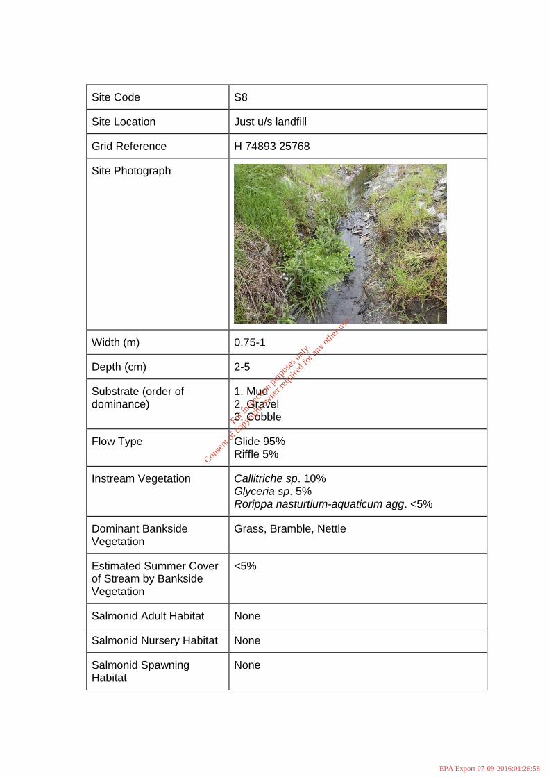
Site Code S8
Site Location Just u/s landfill
Grid Reference H 74893 25768
Site Photograph
Width (m) 0.75-1
Depth (cm) 2-5
Substrate (order of dominance)
1. Mud 2. Gravel 3. Cobble
Flow Type Glide 95% Riffle 5%
Instream Vegetation Callitriche sp. 10% Glyceria sp. 5% Rorippa nasturtium-aquaticum agg. <5%
Dominant Bankside Vegetation
Grass, Bramble, Nettle
Estimated Summer Cover of Stream by Bankside Vegetation
<5%
Salmonid Adult Habitat None
Salmonid Nursery Habitat None
Salmonid Spawning Habitat
None
For
insp
ectio
n pur
pose
s only
.
Conse
nt of
copy
right
owne
r req
uired
for a
ny ot
her u
se.
EPA Export 07-09-2016:01:26:58

Site Code S7
Site Location Just d/s landfill
Grid Reference H 75565 25657
Site Photograph
Width (m) 1-1.5
Depth (cm) 5
Substrate (order of dominance)
1. Cobble 2. Gravel 3. Mud 4. Sand
Flow Type Riffle 5% Glide 95%
Instream Vegetation Glyceria maxima <1% Callitriche sp. <1%
Dominant Bankside Vegetation
Grass, Conifer, Hawthorn, Sycamore
Estimated Summer Cover of Stream by Bankside Vegetation
20%
Salmonid Adult Habitat Poor
Salmonid Nursery Habitat Fair
Salmonid Spawning Habitat
None-Poor
For
insp
ectio
n pur
pose
s only
.
Conse
nt of
copy
right
owne
r req
uired
for a
ny ot
her u
se.
EPA Export 07-09-2016:01:26:58

Site Code Site 0155
Site Location South Bridge Dunfelimy
Grid Reference H 76656 24048
Site Photograph
Width (m) 3
Depth (cm) 8-15
Substrate (order of dominance)
1. Cobble 2. Gravel 3. Mud
Flow Type Riffle 60% Glide 40%
Instream Vegetation Bryophytes <5%
Dominant Bankside Vegetation
Hawthorn
Estimated Summer Cover of Stream by Bankside Vegetation
15%
Salmonid Adult Habitat Poor
Salmonid Nursery Habitat Good-Fair
Salmonid Spawning Habitat
Poor
For
insp
ectio
n pur
pose
s only
.
Conse
nt of
copy
right
owne
r req
uired
for a
ny ot
her u
se.
EPA Export 07-09-2016:01:26:58