scone airport master plan final report - upper hunter … · 2016-09-05 · scone airport master...
TRANSCRIPT

SCONE
AIRPORT
MASTER PLAN
FINAL REPORT
Prepared for Upper Hunter Shire Council
June 2016

Scone Airport Master Plan Report
1
Table of Contents 1 Introduction .......................................................................................................................... 2
1.1 Methodology ......................................................................................................................... 2
2 Airport Background and Regional Context ............................................................................ 4
2.1 Airport Business Model ......................................................................................................... 5
2.2 Regional Context ................................................................................................................... 6
3 Existing Airport Facilities ....................................................................................................... 8
3.1 Runway 11/29 & Runway Strip - Physical Features ............................................................... 8
3.2 Taxiways .............................................................................................................................. 10
3.3 Apron and Aircraft Parking Areas ........................................................................................ 12
3.4 Terminal Building ................................................................................................................ 12
3.5 Privately Owned Facilities ................................................................................................... 12
3.6 Airfield Lighting ................................................................................................................... 13
3.7 Facilities for Access in IMC .................................................................................................. 13
3.8 Summary of Compliance and Other Operational Issues ...................................................... 14
4 Air Traffic Demand Forecast ................................................................................................ 15
4.1 Historic Aviation Activity ..................................................................................................... 15
4.2 Air Traffic Forecast Scenarios and Methodology ................................................................. 18
4.3 Annual projections .............................................................................................................. 20
4.4 Aircraft Parking Stand Requirements .................................................................................. 21
5 Planning Parameters for Airport Master Planning .............................................................. 23
6 Site Development Options .................................................................................................. 23
6.1 Review of Airport Development Options ............................................................................ 33
7 Council Preferred Option and Airport Site Development .................................................... 38
7.1 Airport Drainage.................................................................................................................. 38
7.2 Safeguarding for Ultimate Airport Development ................................................................ 40

Scone Airport Master Plan Report
2
1 Introduction
In late 2015, the Upper Hunter Shire Council commissioned three consulting and Leading Edge Aviation Planning Professionals (LEAPP) to prepare a long term Airport Master Plan for the Scone Airport. The aim of the plan is to provide a guide to the Council as to how the airport might best develop over the next 20 years to 2035, considering growth in aviation demand, upgrading requirements to meet current and future safety compliance standards, land development needs to accommodate aircraft operations and parking requirements over the long term, and expansion of facilities and services offered by the Council to aviation users. The Airport Master Plan provides Council with the necessary information to be able to plan for the long-term strategic development of the airport site, along with guidance to enable short term tactical decisions to be made within the longer-term context. Furthermore, the plan sets out the needs for land use planning controls to ensure that obstacles and other incompatible development does not constrain the airport operation in the future. In developing the master plan, and in consideration for the strategic nature of the document, the objectives of the Master Plan have been defined so as to:
Establish a strategic direction for the development of the airport over a 20-year horizon;
Identify and safeguard the airport lands for future development as required; and
Investigate methods by which the airport can operate more efficiently in the short to medium term.
1.1 Methodology
To achieve these objectives, the plan has considered future aviation demand, the engineering implications of the site, the local community, user requirements, and the regulatory framework by which the airport is governed. In doing so, several key activities were undertaken:
Site Visit: An initial site visit was conducted in mid-September, 2015 to the Scone Airport with the aim of familiarising the project team with the general layout of the site and the key challenges of the existing facility, and enable a high level assessment of obstacles to be carried out as well as an inventory of facilities on the site, and review of the airport infrastructure from a safety, operational, and condition standpoint. Note this visit did not permit access to the runway due to aircraft operations underway and lack of a radio-equipped escort.
Stakeholder Consultations: A series of consultations with airport users was carried out in the initial phases of the study. Users contacted include: o Airspeed Aviation o Scone Aero Club o Pays Air Services o Execujet – Singapore o Execujet – Sydney o Manildra o Stanbroke Feedback from airport users on the condition of the airport and its facilities was largely consistent, with several key issues highlighted:
Scone Airport Master Plan Report
3
Congested apron / aircraft parking: Several of the business jet operators stated that there are times when, due to aircraft already parked on the apron, passengers were disembarked on the runway and the aircraft returned to the port of origin.
Location of the fuelling facilities: Several parties have mentioned that the location of the fuel dispenser is a concern, both from an operational and safety point of view. One jet operator stated that jet blast from their aircraft may be a safety issue for people using the area when they are manoeuvring on the apron.
Drainage is a concern for airport management and locally based operators. This comes in the form of ponding of water and localised flooding on the site, and is also a concern for affecting the condition of the pavements.
The airside pavements are breaking up in some areas and this could cause damage to aircraft propellers and through FOD ingestion into turbine engines.
The equine industry is the main generator of business jet traffic to/from Scone. These aircraft types are considered to be the critical design aircraft for the airport, both currently and for the future.
Locally-based operators have development aspirations for their companies that would affect the long term development of the airport lands. These include the potential commencement of RPT services and development of airport lands for expanded aviation services such as an aircraft museum.
Data Collection and Review: An extensive data collection task was carried out to assist with the master plan development. Information sources were:
o Airport operational statistics – available from FY-10 to FY-15; o Airport management committee meeting minutes; o Scone Airport 2014 Strategic Plan; o Previous master planning and safety inspection documents as compiled by “enstruct
consulting”; o Technical survey drawings of the airport layout and land ownership; and o Economic and regional development documents and reports

Scone Airport Master Plan Report
4
2 Airport Background and Regional Context
The Scone and Upper Hunter Airport is a general aviation airport serving the town of Scone and the Upper Hunter Shire. Located approximately 300km north of Sydney and 150km northwest of Newcastle by road, the airport currently supports a variety of small aviation businesses and service providers in addition to a multitude of propeller and jet aircraft flying to/from the airport. Owned and operated by the Upper Hunter Shire Council, the airport is understood to occupy a land area of 55.9ha., which includes parcels of the airport lands that have been sold off to private aviation businesses and aircraft owners for hangar development. The airport is accessed from Bunnan Road and is some 3km west of the centre of the Town of Scone. Exhibit 2-1 illustrates the airport in its regional setting. There is currently no Regular Passenger Transport (RPT) operation at the airport, although it is understood that there may be investigations underway. At one time the airport did accommodate scheduled passenger services provided between Scone and Sydney by Yanda Airlines. This airline used to fly a “milk-run” service between centres in the Hunter Region, connecting these to Sydney with 9-seat aircraft. This service proved to be uneconomic once Sydney Airport controlled its slot access and increased it handling charges. The Yanda Airlines service ceased operation altogether in 2011 when the airline was grounded due to safety issues.
Exhibit 2-1
Image: Google Maps

Scone Airport Master Plan Report
5
According to the Scone Airport Strategic Plan 2014, the airport was constructed in 1958 for use by Fokker Friendship F27 aircraft as the design aircraft. Since that time, the airport has undergone several upgrades both for operational and safety compliance reasons. Currently, the airport handles approximately 4,000 aircraft movements per year, with these ranging from light single engine aircraft up to medium executive jets. The airport acts as a base of operations for three commercial aviation operators, a local aero club, and a number of owners and operators of light aircraft. Two of the larger operators account for the bulk of the aviation activity at the airport due to their commercial charter flight activities, as well as fire-bombing, aerial applications for agriculture, and flying training. A significant use of the airport by business aviation operators also occurs. Clients of the corporate jet operators are generally those with interests in the local equine industry. There are a number of airports within reasonable proximity to Scone that could be considered to be competitors, competing to provide services to general aviation operators. Review of other airports in the region suggests that the following airports could, or do, compete with Scone Airport for air traffic. These are:
Quirindi – 75km away
Cessnock – 120km away
Maitland – 120km away
Newcastle – 150 km away While Newcastle Airport is a large regional hub, handling over 1.2m passengers per year, it can be regarded as an aviation competitor due to the substantial road network from the city through the Hunter Region. This allows general aviation visitors to fly into the airport and have good access to other parts of the area.
2.1 Airport Business Model
The airport generates revenue through the charging of landing fees to aviation users to assist in covering the cost of operating the facility. The airport currently operates at a loss of approximately $250,000 per annum. To lessen the impact of this annual loss, and provide funding for future capital works at the facility, it is understood that Council has taken steps to increase the fees and types of charges to be levied at the airport. These include:
Increasing aircraft landing charges
Introduction of aircraft parking charges
Examining leasing of airport lands for development A high-level review of rates and charges at similar airports to Scone suggests that it is not uncommon for airports to stipulate these fees, or a combination thereof, as well as other charges. Table 2-1 provides a breakdown of the types of charges levied at other comparable airports.

Scone Airport Master Plan Report
6
Table 2-1
Airport Airport Type Types of charges
Cessnock GA Flat landing fee / t of MTOW, increased charge for night ops.
Goulburn GA Flat charge for Ultralights. Flat landing fee / t MTOW. Graduate parking charges by MTOW.
Maitland GA Flat landing fee / t MTOW. Additional training charges.
Moree GA (formerly RPT) Graduated landing fees based on MTOW. Parking charge per engine per day.
Mudgee RPT Flat landing fee / t of MTOW.
Narrabri GA (formerly RPT) Graduated landing fees based on MTOW. Flat Parking charges for aircraft > 1.5t MTOW.
Quirindi GA Flat landing fee / t MTOW. Per passenger charge for RPT. Per annum charge for parking and apron use.
The airport has, in previous years, sold off considerable portions of land to private owners. Whilst this has considerable short term benefit for the council, it limits its revenue generating ability in the long term, in addition to creating development constraints. Leasing arrangements are typically more common at airports as it gives operational and commercial flexibility to all stakeholders whilst providing an income stream to the Council to offset the expenses of the facility. These agreements can vary considerably from the simple leasing of land areas to users to more complex contracts where Council agrees to build and long term lease facilities to users. In all these agreements, Council acts as a landlord for the facility, enjoying long term control over the infrastructure whilst providing users with facilities as required. Charges for leasing agreements are usually constructed through independent land valuations, generally taking into account the opportunity cost of the property, ultimately working out a fee per square metre. Where facilities are constructed and leased out, they are usually charged by an examination of an appropriate depreciation schedule in addition to a suitable rate of return above this value. In addition to leasing out of airport lands for development, another revenue generating avenue is the leasing of parking areas to specific users. Currently the airport does not administer leasing charges for these spaces however enhancements to the overall parking layouts, and where possible separating and individualising tie down areas, may open up this revenue source. In turn, operators would benefit from a dedicated and maintained parking area for their aircraft.
2.2 Regional Context
The Upper Hunter Shire is home to an estimated 14,500 residents according the 2011 ABS Census. This accounts for 2% of the total for the Hunter Region (approximately 650,000 residents). The population of the region has remained relatively stable over the previous 15 years which is in contrast to the Hunter region overall that has seen consistent growth over the timeframe. The increase in coal mining activity throughout the Hunter region may be one of the reasons for the growth. The Shire is most famously known as the horse capital of Australia with the area the largest horse rearing region in the country. According to the Upper Hunter Region Equine Profile – June 2013 published by the Department of Primary Industries, the region is second only to Kentucky, USA in
Scone Airport Master Plan Report
7
terms of the concentration of thoroughbred stud properties. The report states that in 2006, there were 119 horse studs located in the Upper Hunter, accounting for over 6,500 horses and 600 FTEs. The number of horse studs made up 49% of the total found in the greater Hunter Region. In terms of production, the area accounts for approximately 20% of all stud horses in NSW Outside of the equine industry, the region’s underlying economic sectors are focused on agriculture, retail, education, health care, and accommodation/food services. The mining industry, which is a large economic driver in other parts of the Hunter Valley, represents approximately 2% of all output. Table 2-2, provides a breakdown of economic activity by sector.
Table 2-2 Industry Sector $m %
Agriculture, Forestry & Fishing* $292.8 23%
Manufacturing $213.0 17%
Rental, Hiring & Real Estate Services $143.0 11%
Construction $114.7 9%
Retail Trade $55.8 4%
Accommodation & Food Services $54.9 4%
Transport, Postal & Warehousing $54.8 4%
Public Administration & Safety $50.2 4%
Professional, Scientific & Technical Services $49.7 4%
Education & Training $49.0 4%
Health Care & Social Assistance $46.5 4%
Financial & Insurance Services $37.9 3%
Wholesale Trade $35.2 3%
Other Services $20.7 2%
Mining $19.4 2%
Electricity, Gas, Water & Waste Services $15.6 1%
Arts & Recreation Services $14.7 1%
Administrative & Support Services $10.6 1%
Information Media & Telecommunications $2.0 0%
Total $1,280 100% Source: NIEIR *Includes the equine industry

Scone Airport Master Plan Report
8
3 Existing Airport Facilities
The Scone Airport presently operates at a movement rate on the runway in the range of 3500 annual movements (FY 2015) to 5300 annual movements (FY 2014). Aircraft using the runway are primarily light single engine aircraft within the performance/size definition of ICAO Code 1A and used for flight training and private recreational flying. However, the airport is also used by light and medium twin-engine aircraft in ICAO Codes 1B and 2B, and by a number of business jets that represent ICAO Codes 3B and 3C. There are occasional flights into the airport by larger corporate jet aircraft meeting the criteria of ICAO Code 4C, however these are infrequent and not operating at maximum gross weight due to the limitation of the runway length for Code 4C aircraft operations. While the dominant group of aircraft using the airport are light single and twin engine aircraft, the critical aircraft for the purposes of airport safety compliance are those defined under the ICAO Runway/Aircraft code system as being Code 3C aircraft. As the airport has published instrument approaches with minima below those for visual operations, the runway system is required to meet the safety standards for instrument non-precision operations for Code 3C aircraft, and all obstacle clearances on airside where this class of aircraft are permitted to operate also have to be provided to Code 3C criteria. Operations at the airport also take place under instrument meteorological conditions, and instrument approaches are provided as guidance for these. Operations under IMC are, however, governed by safety clearances to ensure safe operations in what is a potentially hazardous aviation environment due to the presence of high ground to the southeast, east, northeast and northwest of the airport. Circling operations under IMC are restricted to within 3NM of the airport as a result of the surrounding high terrain. Such operations in IMC are also penalised by having high minimum descent altitudes. As far as the airport infrastructure and facilities in place at the airport are concerned, these have been reviewed during an initial site visit in 2015 and as a result of subsequent documentation review. The major facilities of the airport are discussed below and illustrated in Exhibit 3-1.
3.1 Runway 11/29 & Runway Strip - Physical Features
Scone Airport has a single paved runway with an alignment of 121°- 301°M, and designated as Runway 11/29. The runway is reported in the AIP-ERSA as being 1404m in length and 30m wide. However, from digital mapping, the runway measures only 1400m. As such, an error exists either in the length declared to Airservices Australia or in the digital survey mapping of the airport. The threshold of Runway 11 at the northwest end of the runway is at 225.8m (741ft) ASL, while that for Runway 29 at the southeast end is at 215m (705ft) ASL. It is recommended that council survey the runway to determine its true dimensions and ensure the ERSA is correct. The runway slopes downhill from northwest to southeast with an elevation difference of 11m (36ft) between the two ends of the runway, and an overall average gradient of 0.8%. Much of this difference in elevation on the runway occurs in the southern half of the runway, resulting in an inability for the pilot of an aircraft at one end of the runway to see an aircraft at the other end of the runway. Despite the actual line of sight between the runway ends meeting MOS Part 139 compliance standards, this does, nevertheless, create a safety hazard for operations on the runway since aircraft can access either end of the runway yet be unaware of another aircraft on the runway unless specific radio calls are made.


Scone Airport Master Plan Report
10
A Runway End Safety Area of 90m in length is provided at the northwest end of the Runway in front of the Runway 11 threshold to protect aircraft that may land short on Runway 11, or when over-running the runway on take-off or landing on Runway 29. This complies with the CASA MOS Part 139 standards for RESAs. The lands at the southeast end of the runway, between the end of the runway strip and the airport property boundary, do not provide space for a full 90m RESA to be declared under current standards to protect for aircraft when landing or taking off from Runway 11. Currently, for existing runways and where no increase in runway length is applied, it is permissible to measure the length of a RESA from the end of the runway pavement, as provided under the earlier MOS Part 139 standard (which did not comply with ICAO Annex 14), and in that respect the RESA at the southeast end of the runway is technically permitted to be declared as such. However, prudent safety management of the airport would suggest rectifying this situation in order to comply with current Part 139 standards in view of the risk of a high performance aircraft, such as a corporate jet, over-running the end of the runway, either on landing on Runway 11 or following an aborted take-off from Runway 11, particularly as this runway operation is downhill towards the southeast. The runway was overlaid in 2011 with a 50mm asphalt wearing course designed to add strength and to correct a one-way transverse grading on the original runway. Its strength is currently reported to have a Pavement Classification Number (PCN) of PCN 15 on a category “C” subgrade and with a tyre pressure limitation of 1.2MPa. The official pavement strength description for Runway 11/29 is PCN15/F/C/1200. It is understood that the PCN rating has been calculated through desktop assessment from available data, which during a review of the documentation was found to potentially have inconsistencies. In order to maintain this rating, as Council has stated their intention in doing so, further investigation is warranted to accurately determine the pavement conditions of the facility. The runway strip is declared as 150m wide with a 90m wide graded area around the runway, and is consistent with the applicable safety standards.
3.2 Taxiways
Runway 11/29 is connected to a public apron by a single 15m wide stub taxiway, while a partial parallel taxiway, 7.5m wide, runs along the northeast side of the runway for 615m, or almost half of the northern section of the runway, and links the threshold of Runway 11 to the stub taxiway and to various private hangars and hangar lots. This taxiway is narrow and therefore not usable by all aircraft visiting Scone Airport. In addition the taxiway is in poor condition as the underlying soil conditions have resulted in rippling of the pavement as may be seen in the photograph in Exhibit 3-2. As a result, part of this taxiway has been closed. However, additional pavement deterioration is also occurring with tearing of the surface wearing course and deep cracks appearing as per the photograph in Exhibit 3-3. Previous pavement testing for the runway did not assess the pavement strength of this taxiway and therefore, the strength is unknown however surface conditions require closure of the remaining portions of the taxiway or rehabilitation. The taxiway pavement was not overlaid with asphalt at the time of the overlay of the runway, but it is evident that the issues associated with this pavement are not surficial in nature and are most likely due to problems in the subgrade. The strength of the taxiway pavement is quite probably below that of the runway and point to a need to upgrade the pavement to match the runway strength if it is to be used in the future. If the pavement issues are as suspected, rehabilitation cannot be achieved through application of an asphalt overlay.

Scone Airport Master Plan Report
11
Exhibit 3-2
Exhibit 3-3

Scone Airport Master Plan Report
12
In addition to the stub taxiway and partial parallel taxiway to the runway, there are a few other taxiway connections to the runway from private properties that abut the airport. Two of these are grass taxiways that lead from the Pays Aviation Hangar to the runway south of the public apron, while two more are at the southern end of the runway and provide access to the runway for two private properties southeast of the runway itself. It appears these are not paved taxiways. A single taxiway also exists from the eastern edge of the public apron directly into the Pays Aviation property. This taxiway is sealed but in a deteriorating condition. No pavement data exists for this taxiway and therefore, its strength is unknown. All of these taxiways are for private use only.
3.3 Apron and Aircraft Parking Areas
The airport is served by a main public apron having an area of approximately 6000m2. This has a bitumen sealed pavement of unknown strength. The apron is used by visiting aircraft as well as by locally-based aircraft for both loading/unloading and parking. Currently, given its present size, the apron is not able to accommodate more than 1 jet aircraft at a time particularly when part of the apron area is being used for overnight parking by other aircraft that are based at Scone Airport. The condition of the apron pavement is poor, with cracking and rutting occurring in places, particularly near the fuel dispenser pump where aircraft stop while taking on fuel or taxi through this area to access the Airspeed hangars and the hangars to the northwest of the Terminal Building. As with the taxiways, the earlier pavement testing done in 2006 did not evaluate the pavement strength of the main apron and, therefore, its strength is unknown. Given its apparent condition, and evidence of subsurface failure, it is probable that the strength of the apron is below that of the runway. Grass tie-down aircraft parking areas are provided in between the taxiway that extends from the main apron to the Pays Air Services property, and the runway strip, near the windsock. In addition, grass tie-down parking areas are available on the Northwest side of the main apron. A fuelling facility for 100LL AVGAS is located on the edge of the public apron, in between the Terminal Building and the Airspeed property.
3.4 Terminal Building
A small Terminal Building is located adjacent to and on the northeast side of the main public apron. The facility has an associated public car park which is used by many airport visitors as the main airside gate is located beside the Terminal Building.
3.5 Privately Owned Facilities
The Council has, over time, sold off some of the original airport lands to private individuals and companies. It is understood that this has been done to raise funds to cover the operating deficit on airport operations. As a result, aviation commercial companies and a number of individual aircraft owners now own parcels of land abutting the runway/taxiway system. While airside-accessible lands at an airport are always viewed as having prime value as such land is normally very limited, once lost to the airport through private sale, such land can almost never be replaced should it ever be necessary to accommodate additional demand for airside development. In the case of Scone Airport the location of the privately-owned plots of airside land has created a constraint on the development of airside-accessible land for future use for hangars, aircraft parking areas, aprons and taxiways. Some of the owners of private lots now own land that would be required to be kept obstacle-free under the aviation safety standards, while some have constructed their own taxiway access to the runway.

Scone Airport Master Plan Report
13
While active aviation businesses are operating on privately-owned lots on the airport, it is understood that some of the privately-owned hangars are not being used for aviation purposes and Council has expressed concern about this. The more normal practice is to preserve and protect control over airside-accessible lands at an airport, and only lease out to companies and individuals land on which to construct hangars and other facilities under strict lease terms governing use, building styles and permitted operations, and such an approach should also be applied at the Scone Airport in the future.
3.6 Airfield Lighting
Scone Airport has a Pilot Activated Lighting (PAL) system. This activates the runway edge lights and blue taxiway edge lighting. The system however has not worked for approximately 20 years with runway lights continuously turned on. It is recommended that a lighting design review be undertaken with a view to upgrade to a system that is cost effective to run and maintain. Despite the existence of a straight-in instrument approach to Runway 29, and published circling approaches to the airport, there are no approach lights provided for either runway approach direction. Provision of a simple approach light system might be beneficial for access to the airport given that there is a known incidence of fog conditions in the Upper Hunter Region.
3.7 Facilities for Access in IMC
Scone Airport is accessible to aircraft under instrument meteorological conditions. It is equipped with a primary instrument approach provided by GNSS/RNAV as a straight-in non-precision approach to Runway 29. This approach enables aircraft to descend straight-in to the runway but only to 875ft above the runway threshold provided a forward visibility of 5km or better is available. The approach is penalised due to the effect of high ground in the vicinity of the airport and is available only for Runway 29. Approaches under IMC to Runway 11 can also be made using the Runway 29 GNSS approach by circling within 3 NM of the airport provided that descent below 1295ft (Category A & B aircraft) is only made once the airport has been sighted, and provided that forward visibility is no less than 2.4km. Scone Airport also has a secondary instrument approach based on an on-site Non-Directional Beacon (NDB) owned and maintained by Airservices Australia. The primary purpose of the NDB at Scone Airport is to function as part of the Airservices’ Backup Navigation Aid Network (BNN) and this will continue to operate as part of the initial phase of the ICAO-mandated transition to satellite-based global air navigation system. Navaids, such as the Scone Airport NDB that form the BNN, will continue to operate during Phase 1 of the Navigational Rationalisation Project, but with the global mandate to transition to satellite-based GNSS systems, the NDB at Scone Airport will become obsolete and will be decommissioned and removed from the airport. This is not expected to occur within the coming 5 years prior to 2020, and it is probable that the NDB may be maintained for a further 5 years beyond that, after which it is likely to be decommissioned and withdrawn from service. Decommissioning of the NDB, and reliance placed on satellite navigation, can therefore be expected to occur within the 20-year planning period of the Master Plan, and the site on which the NDB is presently located can therefore be assumed to become available for alternative development within the Master Plan period. In the meantime, until decommissioned, the NDB at Scone Airport will continue to provide a back-up instrument approach to the airport. However, due to its location of the airport site, the NDB cannot provide straight-in approach guidance to the runway and it therefore functions as an aid to guidance for circling approaches to both ends of the runway. As an aid for circling approaches, the NDB approaches are governed by high operating minima due to the high ground to the southeast, east and north of the airport, with descent authorised to 1295ft above the airport with a minimum forward visibility of 2.km

Scone Airport Master Plan Report
14
3.8 Summary of Compliance and Other Operational Issues
Examination of the airside areas of the airport suggests the following safety compliance and operational issues for the existing airport, and for any planned or proposed upgrading and expansion of the airport: 1. Application of Runway-Taxiway separation standards for the critical aircraft can be applied for
the length of the existing partial parallel taxiway, but would cause an infringement of private property to the south of the Pays Aviation facility;
2. With a Code 3C-compliant parallel taxiway, the required obstacle clearances for Code C aircraft
cannot be provided in front of the private hangars northwest of the apron as construction has been permitted to take place too close to the alignment for a Code 3C taxiway. Restricted Code C operations would have to be imposed for aircraft taxiing in front of these hangars;
3. The required obstacle clearances for Code 3C corporate jet aircraft are not provided on the
present public apron; 4. It is believed that the pavement strength of the taxiway and apron may be below that for the
runway, which is an undesirable situation; 5. While the pilots’ line of sight for the runway does comply with the MOS Part 139 safety standards
once aircraft have begun to move on the runway, the inability for the operator of an aircraft at one end of the runway to see an aircraft at the other end of the runway represents a safety hazard for aircraft. The fact that aircraft can access the runway at the south end and not be visible to aircraft at the north end of the runway could lead to a collision between aircraft;
6. The current requirement for a Runway End Safety Area at the southeast end of the runway is not
met, however the requirement to develop a RESA under the new requirements would only apply at Scone Airport if and when any change is made to lengthen the existing runway. Nevertheless, prudent management and risk awareness would suggest that Council should implement the current RESA requirement at the southeast end of the runway in view of the fact that the runway is now being used by Code 3C jet aircraft, and occasional Code 4C jet aircraft, for which the runway length could be marginal for a Runway 11 landing over-run, or an aborted take-off in wet runway conditions, given that Runway 11 operations are also downhill.
7. The runway approaches do not have the benefit of runway approach lighting, nor are there PAPI
lights provided for approach guidance. In view of the occurrence of fog conditions at the airport, and given the high instrument operating minima imposed as a result of high terrain in the vicinity of the airport, provision should be made for such operational safety improvements. PAPI lights should be installed in view of the downsloping runway when approaching from the northwest to Runway 11, and upsloping runway when approaching from the southeast to Runway 29.

Scone Airport Master Plan Report
15
4 Air Traffic Demand Forecast
4.1 Historic Aviation Activity
Scone Airport caters for a variety of general aviation aircraft types ranging from ultra-light to medium sized jet models. Analysis of historical aircraft movements suggests that the mix of aircraft using the airport has not changed considerably since 2010 (the period that data is available; comment on years prior to this is not possible due to this constraint). Exhibit 4-1, illustrates the aircraft mix using Scone by way of movements and weight class over this time period. For ease of reference, aircraft weight classes have been grouped into letter codes as follows:
MTOW Weight Class Code
Unknown A
1 – 999 B
1,000 – 1,999 C
2,000 – 2,999 D
3,000 – 5,699 E
5,700 – 14,999 F
15,000 – 30,000 G
+30,000 H
Exhibit 4-1
Source: Airport statistics The “Unknown” category is believed to be, and supported by feedback from Council, primarily aircraft that did not provide a valid registration over the radio when operating and therefore are not captured by the current data provider.

Scone Airport Master Plan Report
16
Three prominent aircraft types appear as the largest users of the facility as a result of the analysis. These are:
A (1 – 999): Models in this category range from small single engine to ultra-light aircraft
B (1000 – 1999): Encompasses small single engine aircraft such as the C172 or similar
C (3000 – 5699) : Encompasses small and medium sized twin engine commuter aircraft up to 19 passenger capacity
This profile naturally aligns itself with the fleets of the major users based at the airport who generate the most amount of traffic and further demonstrates the primary role of the airport, i.e. providing services to small to medium sized general aviation operations. To illustrate the relative volumes of each category, Exhibit 4-2 provides a breakdown by percentage of total movements by grouping.
Exhibit 4-2
Source: Airport statistics Importantly, there are considerable volumes of other aircraft types, specifically the larger weight classes, which use Scone on a regular basis. In FY-15, there were 121 movements of aircraft 5,700kg and larger. This equates to 3% of the total movement for that year. In FY-10 and FY-11 however this figure was 7% and 8% respectively. Although the more recent years have tended to average around the 2-3% mark, it is possible that the airport could see this level of demand again at some point in the future. In fact, preliminary YTD figures to May-16 indicate that these aircraft movements have increased as ratio of total movements back to approximately 7%. The Council has cited that the increased published PCN figures, which enables these aircraft to operate without prior approval, may be one of the reasons for the additional activity. These aircraft types place the highest level of demand on the facility from a physical sizing point of view. Feedback from the airport management and stakeholders cites handling of these aircraft as one of major operational challenges the airport currently experiences. This challenge is exacerbated when more than one of these types use the airport simultaneously. The increased movements place additional pressure on the airport’s limited parking.

Scone Airport Master Plan Report
17
Table 4-1 provides a recent breakdown of these types by month and movement volumes for FY-15. Note that the table comprises a mix of based and itinerant aircraft. It is important to note that the first 4 months of FY-16 have seen a significant increase in the number of these aircraft types using the airport. Whilst it is too early to infer any discernible trend in the data, it does warrant close monitoring over the short term to understand if this growth will impact facility requirements.
Table 4-1
Aircraft Category Jul
2014 Aug 2014
Sep 2014
Oct 2014
Nov 2014
Dec 2014
Jan 2015
Feb 2015
Mar 2015
Apr 2015
May 2015
Jun 2015
Total
AT-802 F 13 2 8 11 2 2 2 1 7 48
CL-600 G 1 2 1 1 5
B300LW F 1 1
B1900D F 2 2
C550 F 1 1 2
C650 F 5 2 3 3 4 2 4 2 8 1 34
C680 F 2 1 3
F20 F 0
F7X H 1 1
F2000LX G 1 1
LJ35A F 0
G550 H 1 2 3
GIV-X H 1 1
B300C F 1 1
HS125-8 F 1 1
IAI 1124 F 1 1
J32 F 1 1
B200 F 7 2 3 3 15
Total - 18 5 12 14 8 6 3 2 19 5 24 4 120
Whilst the majority of movements for each aircraft type is sporadic or ad-hoc there are a few types that appear to frequent the airport on a regular basis. Ignoring the AT-802 and B200 (these aircraft are based at the airport and do not regularly park at the public apron area), the Cessna 650 and to a lesser extent the CL-600 are the most common types using the airport in these weight groups. On a per week basis, again ignoring the based aircraft, the airport averaged 1 visit per week in FY-15. March and May the outliers with an average of 4 per week in those months. Examining the overall traffic levels from a total perspective, and associated growth rates, yields a fairly stable picture of annual operations throughout the period with exception for the last two financial years. The lower traffic figures experienced in FY-15 can be partly explained by the slowdown of the mining sector, which is serviced through charters by one of the based operators. In that year, C and D aircraft types declined of -21% and -23% respectively. There was a significant decline in the category A “Unknown” however it is not clear whether this equates to a decrease in traffic in this category or a re-capturing of this data in the remaining classes. Given the significant decline in traffic for that year overall, it would be safe to assume that the former is the likely case however. Other classes of aircraft experienced various swings in their respective growth rates however caution should be taken when interpreting the results due to their low bases. Preliminary YTD MAY-16 figures indicate a reversal of this trend with the period experiencing over 100 more landings than the last 3 years average and 885 more landings over the previous financial year.

Scone Airport Master Plan Report
18
Exhibit 4-3 provides the annual movements and associated year-on-year growth rates over the period. Overall, FY-15 traffic decreased 30% from FY-14 and is 21% lower than the previous 5 year average. Data for the 3 months after FY-15, i.e. Jul – Sep, suggests that on a rolling 12 month basis this declining trend is continuing. However, much like the aforementioned low bases for aircraft types, so to should caution be exercised when concluding growth trends from the data as a result of the low operating volumes. Given the charter and ad-hoc nature of the based operators, this trend could change rapidly as operating conditions change from year to year.
Exhibit 4-3
The stability of the annual traffic volumes for the years preceding FY-15 indicates that Scone has a latent demand base of between 4,000 and 5,000 movements per annum. However, the decline in traffic has to be taken into account for forecasting purposes as the drivers of this decrease, e.g. a slowdown in mining activity, may continue for the short term. As such, the FY-15 figures have been used as a base from which the traffic can be derived. If the decline was seen to be an acute anomaly in the data, e.g. the airport was closed due to an extreme weather event for a portion of the year, then using the latent demand base could be justified as a starting datum.
4.2 Air Traffic Forecast Scenarios and Methodology
Three different scenarios have been assessed in developing the air traffic forecast for the airport. Examining traffic developed through low, medium, and high scenarios allows for a suitable range of possible future volumes to be estimated. The ambiguity of future events that would affect traffic volumes can be countered through this approach. The forecasts have been developed through a combination of bottom-up and top-down forecasting techniques with the former used for the initial years of the forecast and the latter for later years when a more econometric approach is warranted. Bottom-up forecasting takes into account short-medium term input from stakeholders, data sources, etc. to ascertain a picture of what is likely to occur over this time frame. A top-down approach in the later years accepts that long term decisions or ideas of

Scone Airport Master Plan Report
19
development vary too significant to reliably forecast. To this end, this approach relies on a view of the wider economy and other demand drivers for the airport. The airport presents an interesting challenge when forecasting potential future volumes given the 1) existing low traffic base and 2) the small number of based operators at the port. These characteristics imply that future forecasts are susceptible to wide variations in percentage terms but not in absolute terms. For example, the basing of a new operator, a dedicated flight school perhaps, at the port may add 1,500 movements a year. Although this is a relatively small number in absolute terms, this would represent a growth from current levels of approximately 50%. When considering the implications of the forecast results, it is important to frame growth rates in this context. The assumptions used in the creation of the forecast scenarios have been developed through consideration and study of the existing operations, feedback obtained from based operators and itinerant users, and the underlying drivers of aviation activity to/from the Upper Hunter Region. Broken down by scenario, the assumption used are as follows: Low growth scenario The low growth scenario represents a subdued aviation operating environment over the 20 year forecast horizon. Key assumptions for the first five years are zero growth for the first two years, reflecting the slowdown in mining charter activity, with a growth rate of 1.5% for three years thereafter. A subdued growth rate of 2.0% is estimated for the remaining forecast periods. Medium (most likely) growth scenario The medium growth scenario represents the airport returning to its latent demand levels over the first five years of the forecast, which equates to an annual growth rate of 3.0%. A 2.5% growth rate is used for the remaining years reflecting a healthy operating environment over those periods. High growth scenario The high growth scenario largely emulates the medium forecast however it takes into consideration the entrance of a new based operator at the airport in FY-20 and an increased initial growth rate of 3.5%. It is assumed that the new operator would be using the common B and C type aircraft and would represent an immediate 30% increase in traffic in the year for those categories (it is assumed that each based operator currently account for approximately 30% of the overall traffic so the model has used this as an input). The high scenario may also account for the possible introduction of RPT services at the port, which it is understood, are currently being considered. As previously mentioned, Yanda airlines operated RPT flights to Scone however these were eventually ceased when the airline was grounded on safety concerns. Depending on the market, RPT flights require a combination of factors to come together for services to be viable in the long term. From the demand side, Scone faces several challenges that an operator would need to address, namely proximity to other airports in the region with substantial network depth and breadth (thereby offering price advantages to consumers) and the driving distance to Sydney (accessed primarily via freeway). RPT services would therefore target a niche sector of the market for consumers that are extremely time poor and require the advantages of local air travel over potentially lower cost alternatives. If RPT services are introduced on a hypothetical 3 per week service, this would generate over 300 movements per year which would nominally affect airport facilities planning in the short to medium term.

Scone Airport Master Plan Report
20
4.3 Annual projections
The forecast results, encompassing all scenarios, are illustrated in Exhibit 4-4.
Exhibit 4-4
Table 4-2, presents the forecast for each scenario in tabular format.
Table 4-2
Financial Year Low Medium High
Historic
FY-10 4,215 4,215 4,215
FY-11 4,227 4,227 4,227
FY-12 4,503 4,503 4,503
FY-13 4,502 4,502 4,502
FY-14 5,075 5,075 5,075
FY-15 3,563 3,563 3,563
Forecast
FY-16 3,563 3,670 3,688
FY-17 3,563 3,780 3,817
FY-18 3,616 3,893 3,950
FY-19 3,671 4,010 4,089
FY-20 3,726 4,130 4,952
FY-21 3,800 4,234 5,075
FY-22 3,876 4,340 5,202
FY-23 3,954 4,448 5,332
FY-24 4,033 4,559 5,466
FY-25 4,114 4,673 5,602
FY-26 4,196 4,790 5,742
FY-27 4,280 4,910 5,886
Scone Airport Master Plan Report
21
FY-28 4,365 5,033 6,033
FY-29 4,453 5,158 6,184
FY-30 4,542 5,287 6,338
FY-31 4,633 5,420 6,497
FY-32 4,725 5,555 6,659
FY-33 4,820 5,694 6,826
FY-34 4,916 5,836 6,996
FY-35 5,014 5,982 7,171
The range of forecast results range from 5,000 – 7,000 annual movements with the most likely, i.e. medium forecast, anticipating approximately 6,000 annual movements in FY-35. The Compound Annual Growth Rate (CAGR) for each of the scenarios are outline in Table 4-3.
Table 4-3
Scenario CAGR (5) CAGR (10) CAGR (20)
Low 0.90% 1.45% 1.72%
Medium 3.00% 2.75% 2.62%
High 6.80% 4.63% 3.56%
As far as the types of aircraft operating at the airport in the future, Table 4-4 shows the breakdown for the medium scenario in five year increments.
Table 4-4
Category FY-15 FY-20 FY-25 FY-30 FY-35
A 267 310 350 396 448
B 1,077 1,249 1,413 1,598 1,808
C 1,290 1,495 1,692 1,914 2,166
D 276 320 362 410 463
E 532 617 698 789 893
F 110 128 144 163 185
G 5 6 7 7 8
H 6 7 8 9 10
Total 3,563 4,130 4,673 5,287 5,982
4.4 Aircraft Parking Stand Requirements
Forecasting the annual aircraft movements provides a basis from which peak forecasts can be derived, in Scone Airport’s case this would primarily equate to the stand requirements for the facilities. The ad-hoc nature of general aviation movements make it difficult to determine peak demand volumes as there is often times no discernible pattern that allows this to be overtly calculated. For reference, airports with RPT services are more easily determined through analysis of scheduling patterns. To this end however, peak period forecasting has been approached by assessing the current stand requirements against annual movements to ascertain the peak to annual ratio. Through the site visit, stakeholder consultations, and subsequent discussion with airport management, the current ratios for each aircraft code (note this is different from the aircraft weight categories previously established) have been calculated as follows:

Scone Airport Master Plan Report
22
Code A: 0.7%
Code B: 0.3%
Code C: 0.03% Using these ratios, the forecast of stand requirements is presented in the Table 4-5.
Table 4-5
Code FY-15 FY-20 FY-25 FY-30 FY-35
A 20 23 26 30 34
B 2 2 3 3 3
C 1 1 1 1 1
Total 23 27 30 34 39

Scone Airport Master Plan Report
23
5 Planning Parameters for Airport Master Planning
The airport is currently served by aircraft meeting the criteria of ICAO Code 3C, with occasional operations by Code 4C corporate jet aircraft. The latter could be regarded as operating into Scone Airport within the flight characteristics of Code 3C aircraft in terms of actual landing and take-off weights and runway performance. Consequently, the planning parameters that should be applied for all airside planning and construction under the Master Plan should be those applicable for Code 3C aircraft operating under instrument non-precision criteria. These parameters have been applied in developing the Master Plan site development options provided for consideration to Council in the section below.
6 Site Development Options
The results of the forecast have been used in the creation of various development options that seek to satisfy these requirements throughout the period. Six options were created to ascertain the best balance of operability for all users moving forward. The various options were focused on provided a solution to the current apron layout area. Assessment of these options has led to the selection and phasing of an ultimate master plan option. The options are presented below. Option A Option A can be found in Exhibit 6-1. This option concentrates development in the existing Terminal Zone. Forecast Code B and C stands can be accommodated in a linier arrangement parallel to the runway with all Code B and C stands fully independent. The airside/landside boundary in this option does not change. Rehabilitating the existing apron pavement would become part of the development of the expanded apron. A full-length parallel taxiway has been shown at a Code B clearance distance. Locating the parallel taxiway at a distance of 93m from the centreline rather than 87m could accommodate Code C aircraft. The restriction however, is that there is inadequate clearance for full Code C aircraft to pass the hangar located near to the Runway 11 threshold. However, this option is unable to accommodate the forecast Code A stands or helicopter stands. Option B Option B as provided in Exhibit 6-2 also concentrates development in the existing terminal and main apron zone. Similar to Option A, Option B continues the use of the existing Terminal Building and access infrastructure. This option provides for 4 jet capable stand on the expanded main apron but is sized to accommodate 2 Code C aircraft stands and 2 Code B aircraft stands. Code A stands are provided that accommodate forecast stand demand until approximately 2027 when this option can no longer accommodate increases in aircraft tie-down positions. Option C An illustration of Option C has been provided in Exhibit 6-3. Option C is similar to Option B however, Council wanted to see how best to preserve the windsock in its current location and provide a limited parallel taxiway. To accommodate the restrictions, Option C reduces the jet capable stands to 3, which corresponds to the forecast 2025 demand level. However, the apron has been sized to enable 2 Code C aircraft and 1 Code B aircraft to use the apron simultaneously. The forecast calls for 2 Code B aircraft and 1 Code C. Code A aircraft stands are the same as in Option B. A total of 28 Code A tie-down stands have been provided which will accommodate forecast demand until approximately 2027.


Scone Airport Master Plan Report
27
Option D To accommodate specific operational helicopter stands, Option D was developed as a modification of Option C. Option D has been provided in Exhibit 6-4. This option reduces the code capability of the jet capable stands to 2 Code B stands and 1 Code C stand. Forecast demand calls for 3 Code B and 1 Code C stands. To accommodate the helicopter stands and the access taxiway clearance requirements, the Code A stand provision further reduces to 25 which corresponds to the Code A aircraft stand demand for 2025. Option E Option E involves development of the main apron area to the North West, in undeveloped land, near the Runway 11 threshold. As ample land exists in this area, this option can accommodate the forecast demand for 4 jet capable stands up to Code C. The new main apron development has been provided in Exhibit 6-5. This provides an opportunity to develop a new Terminal Building and associated car park. Some Code A stands could be provided near the new main apron and additional tie-down stands could be accommodated on the old main apron area as shown in Exhibit 6-5. As shown, this option can accommodate the long term forecast demand for Code A, B, and C stands as well as operational helicopter stands. Option F Similar to Option E, Option F splits development between a new main apron zone as shown in Exhibit 6-7 and an expanded tie-down zone as shown in Exhibit 6-8. Option F, accommodates the forecast demand for 4 jet capable stands. The main apron has been sized to accommodate 2 Code C stands and 2 Code B positions. Similar to Option E, an opportunity for a new Terminal Building exists with the development the new main apron zone. Locating the proposed air museum next to the new terminal and main apron provides for compatible business opportunities such as the development of a café in the terminal building. Option F moves the fuel services to a dedicated aviation fuel apron where aircraft can be refuelled away from other activity. Some aircraft tie-down positions can be accommodated near the new main apron however, most aircraft tie-down is accommodated in the old apron area. Fully developing the old apron area as tie-down and possible ‘T’ hangars results in 38 Code A tie-down positions and possibly ‘T’ hangars for additional 15 aircraft giving a total provision of 53 Code A aircraft. Forecast demand for Code A positions in the Master Plan year of 2035 is 34. As the Code A aircraft tie-down and stand provision can far exceed demand, Option F does not move the windsock. However, this could be moved if needed which would permit additional operational helicopter stands to be accommodated.


Scone Airport Master Plan Report
33
6.1 Review of Airport Development Options
The airport development options were presented to the Council and airport stakeholders for comment. Whilst a wide array of comments were received and considered, there was particular focus on the development of the existing aviation precinct. A number of factors were attributed to the attention given to this area. These included:
Retention of existing sub-divided lots for long-term commercial development. This includes the lots located along Satur Rd and to the North-East of the runway.
Private ownership of airport lands surrounding the proposed developments
Consideration of the forecasted demand levels and acceptance of a lower growth scenario in the long term to provide a more balanced approach to development of the aviation precinct.
Consideration of the viability of larger jet traffic (Code C) and integrating operations of this type into the overall design
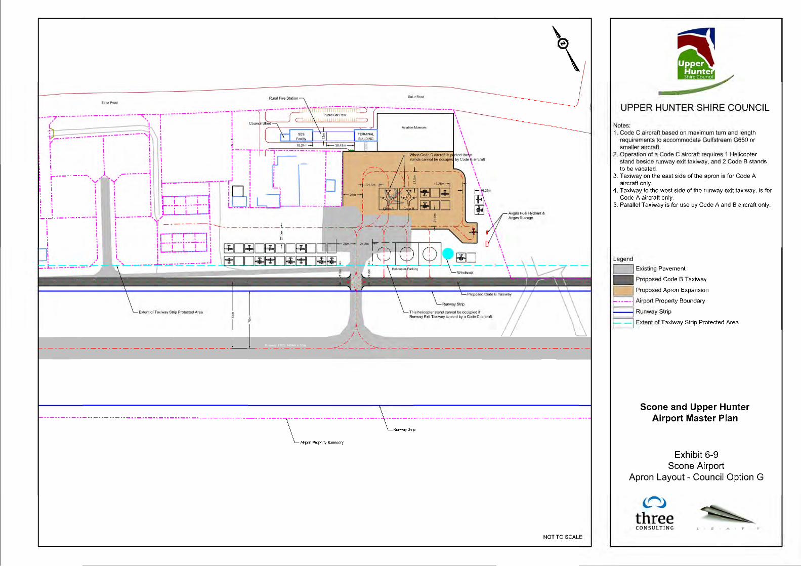
Two new options were developed to address these factors, Option G and H. They are presented below. Option G Exhibit 6-9 illustrates Option G, developed on the instruction of the Council based on feedback from stakeholders. Council direction on the locations of facilities created a layout that concentrates development in the existing Terminal and Main Apron zone. Option G relocates the passenger terminal closer to Satur Road and positions it beside the Aviation Museum. A Rural Fire Station is positioned beside the Passenger Terminal along with a facility for the SES and Council Storage. The main access off Satur Road remains as it is and provides access to a new parking lot. Road access onto airside is however diverted along the side of the parking lot and behind the Council Storage facility, SES and the Rural Fire Station. This layout provides for 32 Code A aircraft parking/tie-down positions, 3 Helicopter parking positions, and 2 Code B aircraft parking positions that can be occupied by 1 Code C aircraft provided both Code B stands are vacant. This provides adequate Code A aircraft parking positions until approximately 2032, and Code B parking positions until 2022. Forecast Code C parking demand requires provision of 1 Code C stand throughout the forecast period. However, the Code C stand can only be used if both Code B stands are vacant and therefore, if a single Code B aircraft is on stand, Code C aircraft could not be parked on the apron. Over the master plan period, this Option does not fully accommodate aircraft parking demand and requires operational vigilance to ensure safety is maintained. In comparison with the forecast, there is a short coming of 2 Code A and 1 Code B parking positions over the 10 year period. As property at the airport is developed, in particular aircraft hangars, there may be an opportunity to address the Code A stand deficiency. This comes from the incentive to use these facilities as opposed to chargeable parking stands. The Avgas fuel dispenser and fuel storage tanks are moved to a dedicated refuelling apron on the southeast corner of the main apron. The refuelling apron is sized to accommodate Code A aircraft only. The Council has made arrangements for provision of Jet-A1 fuel via a mobile dispenser that will be called out based on a prior booking arrangement and therefore, no Jet-A1 fuel is envisioned to be stored onsite. The airport currently has a safety concern related to the profile of the runway. As a result, there is a hump in the middle of the runway which prevents pilots at opposite ends of the runway being able to see the opposing threshold to ensure there are no other aircraft on the runway. To address the issue and improve safety, it is recommended that a full length parallel taxiway be developed. Due to historic

Scone Airport Master Plan Report
34
developments of the airport and surrounding properties, it is not possible to provide a full Code C parallel taxiway. Therefore, provision of a Code B taxiway has been developed for consideration. Access to the main apron from the Runway Exit Taxiway is sized to accommodate Code C aircraft provided the first helicopter stand, on the East side of the Runway Exit Taxiway is vacant. When this stand is occupied, full Code B clearances are maintained. The main apron itself is similarly sized to accommodate Code C aircraft clearances provided the Code B stands are vacant. If an aircraft is occupying the Code B stand, then Code B clearances are available. Code B or C aircraft are unable to operate on the taxiway around the East side of the main apron. This taxiway is sized for Code A aircraft only. The Council will need to establish the appropriate procedures and promulgate those procedures to ensure safety is maintained and potential conflicts are mitigated. The Council may need to liaise with CASA to ensure they are comfortable with the procedures developed by the Council to address the constraints and conflicts that arise from the layout for Option G. Option H Option H is a further refinement of Option G with primary focus on the standards applied to the runway. The current runway is defined as Code 3C, requiring a runway strip width of 150m, or 75m each side of the centreline. Illustrated in Option G, this standard pushes the parallel taxiway clearance limits into the privately owned lots abutting the airport, requiring Council to come to some form of an arrangement with landowners. To circumvent this issue, Council decided to explore the implications of downgrading to Code 2C. A Code 2C runway requires an overall runway strip width of 90m, or 45m each side of the centreline and thus allows for the parallel taxiway to be located away from the airport boundary. Illustrated in the exhibit, the taxiway can be placed 63m away from the runway (centreline to centreline). Designed to Code B standards, an approximate 7m gap remains between the property limits and clearance limits remain. Also displayed in the exhibit are indicative locations of stub taxiways leading to the private lots. They are displayed to illustrate, conceptually, private access to the parallel taxiway. Their exact locations will need to be determined through discussion with property owners and Council. Also displayed are two taxiways leading into the undeveloped lots to the western end of the airport. The western most taxiway is designed for Code B aircraft and with the other, Code A. Council is aware that the current material of the partial taxiways in these locations is not to code and will ultimately need to be removed and upgraded. In the short to medium term these taxiways will be gravel/grassed and will have the ability to be paved at a later date. In support of firebombing operations, Council has decided to retain the two gravel taxiways leading to/from the Pays Aviation precinct. The western most taxiway is retained to its full length for direct runway access whereas the eastern most is to be retained to the parallel taxiway only. In addition, access to the main apron from the Pays precinct has been provided via Code B taxiway to the north of the Avgas refuelling area. This requires the removal of 2 Code A stands previously shown in Option G. This impact is nominal however as reducing the runway code allows for the provision of 17 additional Code A stands (43 in total). The number of Code A stands available exceeds the requirements set-out in the forecast. As with Option G, this option does not meet the forecast requirements for larger jet stands over the entire planning period. Reducing the runway to Code 2C standards limits the type of aircraft that can freely operate to the airport and operational flexibility in the future. The airport does at times handle larger Code 3C business jet aircraft. Under Code 2C standards, operations of these aircraft into the airport would require special dispensation from CASA. Council understands that these movements are limited
Scone Airport Master Plan Report
35
however, demonstrated in the forecast section of the master plan, and subsequent consequences may have negligible impact over the short to medium term. It should be noted that over the long term, and potentially outside of the master planning period, this constraint may need to be addressed. Should the code of the runway need to be upgraded at some point in the future, due to a change in the aircraft mix for example, this would incite a need to re-locate the currently planned airside infrastructure and possible acquisition of privately owned lands, potentially in a similar fashion to what is shown in Option G. Council should make provisions for safeguarding lands in these areas in the event that this action is required.


Scone Airport Master Plan Report
38
7 Council Preferred Option and Airport Site Development
After consultation with Stakeholders, Council selected Option H for the long term development of the airport. Therefore, Option H represents the Council Preferred Option for Scone Airport. The option provides for:
Code 2C runway infrastructure;
43 Code A aircraft parking positions;
Helicopter parking positions;
2 Code B jet aircraft parking positions that can be used as a single Code C aircraft parking position;
New Avgas refuelling facility;
Relocated Terminal Building;
Expanded public parking lot;
Rural Fire Service Station/Facility;
SES Facility;
Location for new Aviation Museum;
New Council Shed; and
Full length parallel taxiway. The Manual of Standards requires the provision of a windsock at the aerodrome. With the runway length of Scone Airport, MOS139 requires a windsock to be located at either end of the runway. However, due to the grading of the site, the availability of power and the need to acquire land, provision of lighted windsocks at both thresholds is prohibitively expensive and may not provide the same level of utility as the existing windsock. Provision of a windsock on the eastern end of the runway may not be possible at all. Discussions with CASA are recommended to illicit their views on installation of additional windsock(s) or retaining the existing. It may be possible to continue to use the existing windsock as the runway length at Scone is only 1404m. Alternatively, CASA may be amenable to the installation of a single unlighted windsock on the western end of the runway in Lot 42, or perhaps on a frangible structures within the airport property on the eastern end, and maintain the current lighted windsock to facilitate night-time operations. It should be noted that Council is installing an AWIS system at the airport which may negate the need for a windsock however the current one will remain in its current position regardless.
7.1 Airport Drainage
Studies of stormwater drainage of the Scone Airport site have been carried out in 2014 by RHM Consulting Engineers of Scone (“Strategic Stormwater Management Assessment – Scone & Upper Hunter Airpark, Bunnan Road Scone”), and in April 2015 by “enstruct Group Pty Ltd” of Sydney (“Scone & Upper Hunter Airport – Stormwater Management Assessment Report”). The lie of the land in the vicinity of the airport is such that there is a small hill immediately west of the airport’s runway, rising to approximately 250m ASL or 25m above the Runway 11 threshold and 35m above the threshold for Runway 29. Surface run-off therefore flows towards the northeast at the northern part of the airport property, and towards the east and southeast for the rest of the airport property. A series of cut-off drains appear to have been constructed to intercept surface runoff across the side of the adjacent hill, however there appear to be no drains on the uphill side of the runway itself. This suggests that there could be rainwater runoff flowing towards the runway, which could also penetrate into the subgrade of the runway under wet conditions. This would appear to be a

Scone Airport Master Plan Report
39
possible drainage risk to pavement subgrade strength that might need to be addressed through drainage in the northwest side of the runway strip, and possibly through subsurface drains below the northwest side of the runway itself. On the northeast side of the runway, rainwater runoff would appear to drain towards Bunnan Road, except where intercepted by drains on the northeast side of the airport property. The RHM study of the stormwater drainage on the airport identified that airport drainage comprised a limited infrastructure, being mainly some isolated dish drains for the taxiway and to convey surface water away from the terminal Building, culverts under the various access roads on site, and table drains for property areas to the northwest of the site. The overall drainage situation was reported to be poor as far as conveyance of surface water runoff from the taxiways and aircraft parking apron is concerned, with ponding and excessive ponding prevalent following heavy rain. RHM concluded that reported and observed problems with drainage on the airport site are a direct reflection of the deficiency in drainage collection and conveyance of surface runoff from buildings and usable lands on the airport. This was reported to be an expected condition given the rather limited stormwater drainage infrastructure that presently exists. Further development of the airport site, such as through development of additional paved areas and buildings was noted as being likely to exacerbate the problems currently noted. The RHM study developed a strategic stormwater management plan based on the airport development plans as existing in 2014. Under the current new Airport Master Plan, land to the east of the Terminal Building (i.e. between the Pays’ site and the Terminal Access Road) is proposed for upgrading to provide additional space for light aircraft tie-down parking and T-Hangars, and to achieve this the land in question would need to be elevated and drained. Similarly, development proposed for the northern part of the present undeveloped part of the site (i.e. northwest of the Airservices Australia NDB site) would be reconfigured and developed as a major apron area, which because of its impervious nature would create a need to provide suitable drainage. Given these changes in the location and nature of on-site aviation development for airside uses, a changed drainage plan would be required as the impervious areas would be increased when compared with the parameters used by RHM in developing the strategic stormwater plan, and in planning for the expected outfall volumes, in 2014. Currently, the Airport Master Plan only exists as a recommended concept for long-term development of the airport lands to the northeast of the runway, with options suggested for phasing this development over a 20-year planning period. As such, and until the Airport Master Plan is made firm through acceptance by Council, it is premature to attempt to define the site drainage provisions. However, it can be said that the principles of the RHM Strategic Stormwater Management Plan would still apply given the fall in the land over the site and the general drainage required. What cannot yet be determined would be the actual number of drains and catch-basins, and the sizing of drainage channels and culverts necessary to accommodate future runoff flows. Once the Airport Master Plan solidifies and is firm, it is therefore recommended that the RHM plan be revised on the basis of the changed development scope and layout. At that time, council should commission a full utilities design encompassing not only stormwater drainage but also electrical power supply and provisions for sewerage and solid waste treatment. While the removal of surface water runoff will need to be planned, and especially so since it is apparent that ingress of water may have created a weakening of the subgrade for the runway, taxiway

Scone Airport Master Plan Report
40
and apron pavements, the planning for drainage should also consider installation of subsurface drainage for the runway, primary taxiways and aprons.
7.2 Safeguarding for Ultimate Airport Development
Council should adopt the MOS Part 139 airport safeguarding standards and apply obstacle limitations on lands surrounding the airport, with particular emphasis on restricting the erection of obstacles in the two approach/take-off areas off the ends of the runway, and on the northeast side of the runway. The required safeguarding is depicted in Exhibit 7-1. It should be noted that municipal controls on land use outside the airport property should be applied within the designated areas and development prohibited where obstacle heights would need to be limited in areas where the required safeguarding would indicate an obstacle clearance limit of less than 10m above natural surface elevations.


Scone Airport Master Plan Report
42
Disclaimer: The information in this report is based upon data provided by external sources. The information provided has not been audited or checked for accuracy except as stated, or any omissions of relevant details or errors in assumptions made underlying any information provided or omissions there from. All such information and assumptions must be checked and verified by the recipient for accuracy and reliability. Any variance in the underlying information will affect the contents, recommendations and advice given. Any alteration in facts and circumstances since any information was obtained or provided will affect the contents, recommendations and advice. No responsibility is accepted for any mis-description, omission, inaccuracy or change. All advice and recommendations are based upon the law and regulations at the date recommendations are formed, unless expressly stated otherwise. No liability is accepted for the effect of any change to the law or its requirements. The recipient must at all times ensure that any such changes do not affect the recommendations and advice given. The contents of all documents, recommendations and advice are for the sole use and purpose of the recipient and named addressee only, and are not for the use of or reliance upon by any other person, entity or related party. All liability whether in contract, tort, by statute, at law or in equity is to the full extent permitted expressly excluded, and where not permitted to be so excluded is limited to the provision of the same services again and/or a refund of any fees paid for those services. The information contained in this document is strictly confidential and is commercially sensitive to three consulting pty ltd. This presentation and all material contained herein is the sole property and copyright of three consulting pty ltd. It may not be reproduced, disclosed or used, in whole or in part, for any purpose without the prior written consent of three consulting pty ltd.