scenarios to reduce forest fragmentation and … 2011 multifunctional landscapes.pdf · land,...
TRANSCRIPT
Carpathian Journal of Earth and Environmental Sciences, February 2011, Vol. 6, No. 1, p. 23 - 34
SCENARIOS TO REDUCE FOREST FRAGMENTATION AND IMPROVE LANDSCAPE MULTIFUNCTIONALITY: A STUDY FROM NORTHERN
ITALY
Patrizia DIGIOVINAZZO1, Gentile Francesco FICETOLA1, Luciana BOTTONI1 & Emilio PADOA-SCHIOPPA1
1 Università degli Studi di Milano-Bicocca, Department of Environment and Landscape Sciences, Piazza della Scienza 1, 20126 Milano, Italy, Corresponding author: [email protected].
Abstract: Fragmentation has negative effects on ecosystems and can cause loss of habitats, increase of edges and isolation. Forests in northern Italy have strongly declined, because of the development of urban land, infrastructures and crops. In suburban areas forest patches often perform a variety of functions. This study used scenarios integrating both ecological and social principles to improve landscape multifunctionality in a suburban area of Northern Italy, with a special focus on the role of woody patches. We evaluated how improving some functions of woody patches (suitability for forest species, mitigation for road impact and recreation) can help creating a multifunctional landscape. We combined the scenario visualisation through GIS, the maximization of functions based on ecological principles, and the use of fuzzy logic. The scenarios obtained show that improving existing woods can help to maximize multiple functions. The scenario improving recreation is the most suitable to increase biodiversity, and it can also help to mitigate road impact. The scenario approach can help decision-makers during the planning process, because it is user-friendly. Comparing multiple scenarios can allow assessing if managing the landscape for one function may also accomplish other function(s). Key words: Fragmentation; Fuzzy logic; Landscape planning; Suburban area; Woody patches.
1. INTRODUCTION
Several studies have analysed the consequences of landscape fragmentation on ecosystems (Jacquemyn et al., 2001, Fahrig, 2003, Honnay et al., 2005) showing negative effects due to loss of habitat, increase of edge and isolation. Configuration, patch size and distance between patches are the landscape structural characteristics that are most influenced by fragmentation, and they are the principal parameters that should be modified, if planners wish to minimize the negative effects resulting from over-exploitation of the land. In human dominated landscapes decision makers planning to create new wooded patches often need tools assess the effectiveness of different afforestation strategies. Multiple ecological questions should be addressed during decision making, such as: where should new woodlands be created, which function of the patches should be maximized, and what does the minimum size need to be? Furthermore, there are also social
issues, because creating new woodlands usually means taking land from agriculture (Lovell & Johnston, 2009b).
Northern Italy is among the most human modified areas in Europe (Pedroli et al., 2007). Deforestation reduced natural vegetation to small fragments in lowland areas, which have key importance as a source of biodiversity (Digiovinazzo et al., 2010); hedgerows are the major ecological corridors available for species dispersal (Sitzia, 2007, Roy & de Blois, 2008). Furthermore, fragmentation due to roads is an increasing problem, like in many other European countries (Forman et al., 2002, Moser et al., 2007). Continuous urbanisation, infrastructure development and expansion of crops are the major causes of loss of natural vegetation in the lowland surrounding the city of Milan (Ficetola & De Bernardi, 2004, Padoa-Schioppa et al., 2006). The process can be seen in aerial photographs over the last 50 years or by cadastral maps from previous centuries.
23
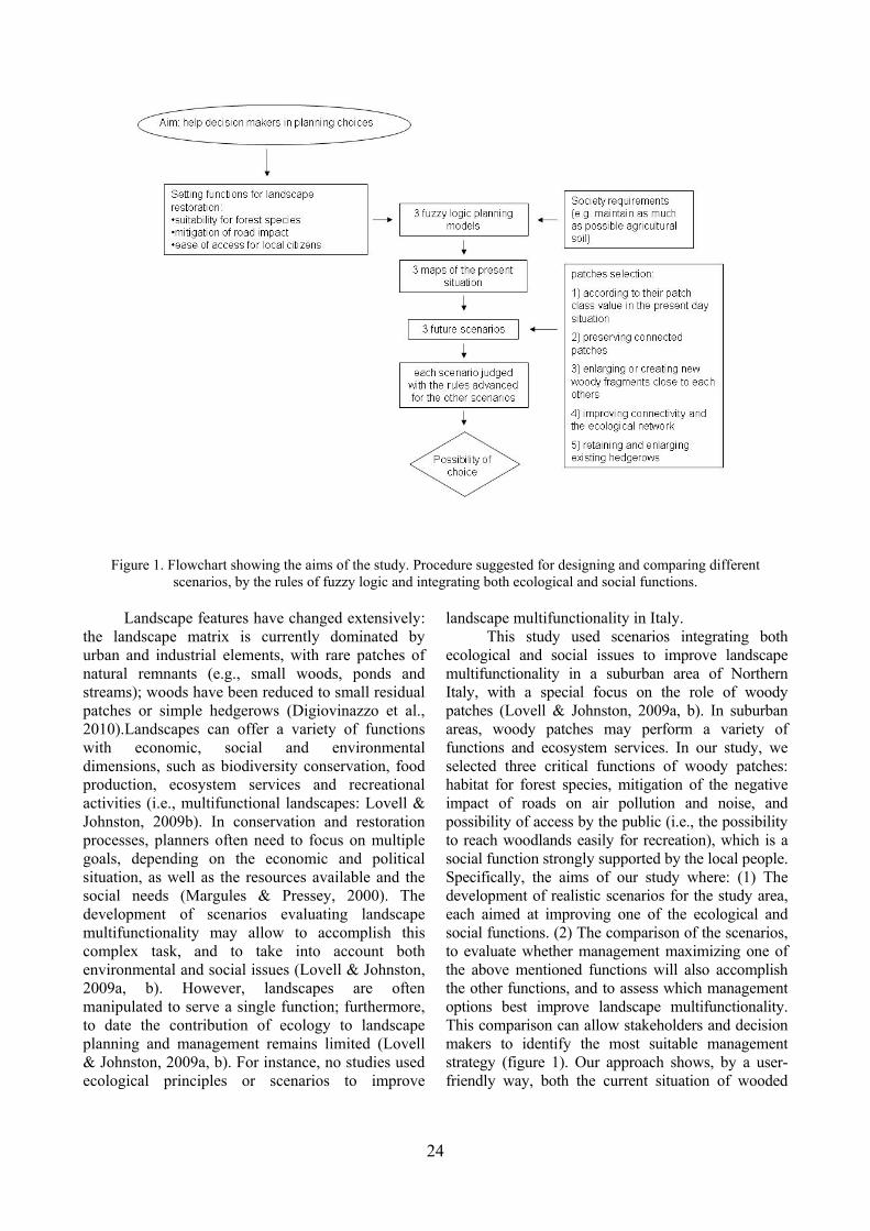
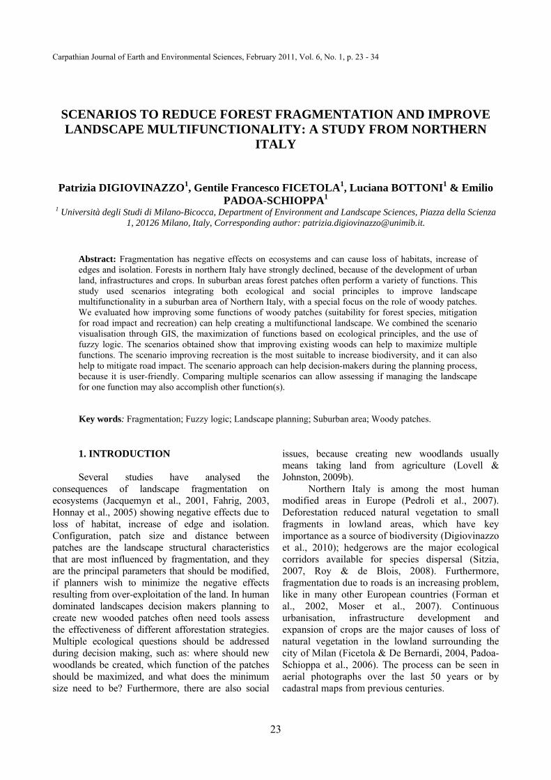
Figure 1. Flowchart showing the aims of the study. Procedure suggested for designing and comparing different
scenarios, by the rules of fuzzy logic and integrating both ecological and social functions. Landscape features have changed extensively:
the landscape matrix is currently dominated by urban and industrial elements, with rare patches of natural remnants (e.g., small woods, ponds and streams); woods have been reduced to small residual patches or simple hedgerows (Digiovinazzo et al., 2010).Landscapes can offer a variety of functions with economic, social and environmental dimensions, such as biodiversity conservation, food production, ecosystem services and recreational activities (i.e., multifunctional landscapes: Lovell & Johnston, 2009b). In conservation and restoration processes, planners often need to focus on multiple goals, depending on the economic and political situation, as well as the resources available and the social needs (Margules & Pressey, 2000). The development of scenarios evaluating landscape multifunctionality may allow to accomplish this complex task, and to take into account both environmental and social issues (Lovell & Johnston, 2009a, b). However, landscapes are often manipulated to serve a single function; furthermore, to date the contribution of ecology to landscape planning and management remains limited (Lovell & Johnston, 2009a, b). For instance, no studies used ecological principles or scenarios to improve
landscape multifunctionality in Italy. This study used scenarios integrating both
ecological and social issues to improve landscape multifunctionality in a suburban area of Northern Italy, with a special focus on the role of woody patches (Lovell & Johnston, 2009a, b). In suburban areas, woody patches may perform a variety of functions and ecosystem services. In our study, we selected three critical functions of woody patches: habitat for forest species, mitigation of the negative impact of roads on air pollution and noise, and possibility of access by the public (i.e., the possibility to reach woodlands easily for recreation), which is a social function strongly supported by the local people. Specifically, the aims of our study where: (1) The development of realistic scenarios for the study area, each aimed at improving one of the ecological and social functions. (2) The comparison of the scenarios, to evaluate whether management maximizing one of the above mentioned functions will also accomplish the other functions, and to assess which management options best improve landscape multifunctionality. This comparison can allow stakeholders and decision makers to identify the most suitable management strategy (figure 1). Our approach shows, by a user-friendly way, both the current situation of wooded
24

fragments and possible improvements, according to the planning choices available, and allows an assessment of different management alternatives. The term “scenario” is used here to describe different possibilities in the future, as well as a series of events leading from the current to a future state (Van Den Berg & Veeneklaas, 1995; see paragraph 2.3 for further details).
2. MATERIALS AND METHODS 2.1 Study area The study area covers the suburbs of Milan
(1,982 km2, with almost four million inhabitants in the metropolitan area) in Northern Italy (Lombardy region). The territory is dominated by agricultural (49%) and urban land (38%), forests cover 6.5% of the landscape. Land-use data were obtained from the 1:10,000 D.U.S.A.F. digital land cover (www.cartografia.regione.lombardia.it) and overlaying aerial photographs to correct possible errors.
Remnant seminatural woods and hedgerows have homogeneous composition, and are dominated by the alien black locust (Robinia pseudoacacia). Oaks (Quercus robur), hornbeams (Carpinus betulus), ashes (Fraxinus excelsior), and maples (Acer pseudoplatanus, A. platanoides, A. campestre) are present where the human influence is limited (Chincarini & Andreis, 2005, Digiovinazzo et al., 2010). Overall, the area of forested vegetation in the suburbs of Milan is 147.3 km2, with 3332 forest patches.
2.2 The fuzzy logic The basic idea of fuzzy logic is that
membership to a set is gradual rather than crisp (Sangalli, 1998, Shepard, 2005). For example, an ecologist who studies the distribution of a given species in a complex landscape may use a crisp set (for each habitat the species is present or absent) or a fuzzy set, where the habitat quality for the species may vary in range from 0 to 1 (Figure 2, Table 1). A fuzzy set is defined “by a membership function that is used to calculate the grade of membership” of the parameter within the fuzzy ranges (from 0 to 1) (Shepard, 2005). Conventionally a value of 1 indicates total correspondence and a value of 0 its absence; a “range of fit” is used to define the membership to each of the given classes (e.g, see Table 1). Intermediate values indicate progressive degrees of membership. Having a possible membership gradient reflects the reality of uncertainty in natural and ecological systems.
Fuzzy sets operate by means of logical operators involving a complemental system, and functions of union and intersection that involve multiple sets: 1) complement. A given set has a complement Ac, where the function is Ac = 1- μ(A) and μ is the function defining the probability of membership of variables (thereafter: membership function); 2) union (symbolically ∪). The union of two sets is defined as the set which includes all the members of each set and its membership function is defined as μ(A ∪ B) = μ(A) ∧ μ(B) [∧ denotes maximization]; 3) intersection (symbolically ∩). The intersection of two sets is defined as the new set which contains only members belonging to both sets μ(A ∩ B) = μ(A) ∨ μ(B) [∨ denotes minimization]. The union corresponds to logical operator OR and the intersection to logical operator AND. Linguistic variables and their associated terms are the data to which fuzzy logic is applied (Shepard, 2005). The IF-THEN rules describe the conditions for combining fuzzy sets. For example: IF forest cover is high AND forest patches are large, AND Sciurus carolinensis (the invasive grey squirrel) is absent; THEN habitat suitability for Sciurus vulgaris (the native red squirrel) is good.
A fuzzy system has functions for entering data, rules, and exit functions. When the variables have been selected for inclusion and then defined linguistically, a membership function is proposed that attributes the likely degree of membership. The rules of the system determine the inference among different sets. The use of logical operators (AND, OR) and rules (IF, THEN) allow a new system to be produced that may be converted, if necessary, into a new crisp set (defuzzification of the membership functions).
The use of “word arithmetic”, where logical operators (AND, OR) are applied to fuzzy groups, is derived from theoretical logic applied to engineering and subsequently to biological sciences (Sangalli, 1998). In ecology, concepts such as environmental quality, habitat suitability, and sustainable development are particularly suited to the use of fuzzy logic. In the ecological literature there are numerous examples of researches where fuzzy sets are used to analyze multiple topics, such as forest management (Ducey & Larson, 1999), anthropic pressure on vegetation (Feoli & Zerihun, 2000), water quality (Krysanova & Haberlandt, 2002), population dynamics and environmental suitability (Barros et al., 2000). In contrast to habitat suitability models (e.g., Guisan & Thuiller, 2005), fuzzy logic allows the use of existing knowledge from multiple sources to identify a range of values, instead of a crisp sets (Enea & Salemi, 2001, Adriaenssens et al., 2004).
25
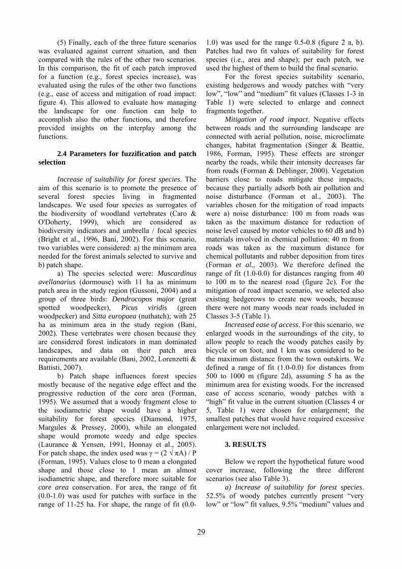
Figure 2. Fuzzification of the ecological rules. a) b) Increase of suitability for forest species. a) For area, the
range of fit (0.0-1.0) was used for patches with surface in the range of 11-25 ha. Fit = 0.0 when x ≤ 11 ha (minimum area required for Muscardinus avellanarius); fit = 1 when x ≥ 25 ha (minimum area required for a group of forest bird species). b) For shape, the range of fit (0.0-1.0) was used for the range 0.5-0.8. c) Mitigation of road impact. The range of fit (1.0-0.0) varies from 40-100 m. Fit = 0.0 when x ≤ 40 m (maximum distance for reduction of chemical pollutants and rubber deposition from tires); fit = 1 when x ≥ 100 m (maximum distance for reduction of noise level). d) Ease of access. The range of fit (1.0-0.0) varies from 500-1000 m. See Methods for further details on the ranges of fit.
Table 1. Defuzzification of the membership function
values
In this study, we used fuzzy logic to build
scenarios describing the potential effect of management on ecological and social functions (increase of suitability for forest species, mitigation of road impact and ease of access), assigning suitability values following these membership functions for variable “x” (Figure 2): 0 when x ≤ xmin; (x – xmin) / (xmax – xmin) when xmin < x < xmax; 1 when x ≥ xmax (Hill & Binford, 2002). The trend of the functions (Figure 2) depends on the ecological
parameter selected. To assess the suitability for forest species, we selected a pool of forest vertebrates, assuming that suitability increases linearly at increasing patch sizes and at decreasingly elongated shape (Diamond, 1975, Forman, 1995). For ease of access, fit is highest for patches closest to human settlements. Finally, woodlands close to roads are assumed to have highest potential for the mitigation of road impact (see below paragraph 2.3).
2.3 Designing the scenarios: overview Scenarios used as “visual simulations” in
landscape planning can be drawn by artists or modelled with suitable software (Swaffield & Fairweather, 1996, Lange et al., 2008), to predict landscape changes according to the effect of ecological factors or policy decisions (Santelmann et al., 2004, Bolliger et al., 2007).
Class Description Fuzzy fit range 1 very low 0 ≤ fit ≤ 0.2 2 low 0.2 < fit ≤ 0.4 3 medium 0.4 < fit ≤ 0.6 4 high 0.6 < fit ≤ 0.8 5 very high 0.8 < fit ≤1
26

Figure 3. Examples of the restoration. Woody patches have different fit values depending on the parameters considered, both in the present situation and in the scenario simulation. a) Increase of suitability for forest species. We have chosen patches from “very low” to “medium” fit values and we have increased them connecting small woody fragments with hedgerows. b) Mitigation of road impact. We have chosen to enlarge and link existing hedgerows. c) Increased ease of access. We improved woody patches with “high” fit values; smaller patches that would have required excessive enlargement has not been included.
27
In these studies, the aim is to examine which scenarios are preferred by stakeholders, and if they are environmentally sustainable (Palang et al., 2000, Ozesmi & Ozesmi, 2003, Tress & Tress, 2003). For instance, Palang et al. (2000) built landscape scenarios on the basis of different policy decisions so that local people and administrators could express their preferences, using a questionnaire or through an interview. In Tress & Tress (2003), four extreme scenarios were described, based on aesthetic points of view; subsequently stakeholders judged each scenario by means of questionnaires and interviews. Lu et al. (2006) determined the welfare of a region, by selecting ecological and socio-economic indicators, and then classifying each township through fuzzy logic. The convenience of scenario visualisation was combined with the maximization of environmental and social functions (Lovell & Johnston, 2009a, b), on the basis of ecological principles and the use of fuzzy logic. The case study was carried out in the following five steps.
(1): Fuzzy rules were established for the patch features considered (patch shape, area, and distance from roads and from urban land), depending on the functions to be maximised, on the basis of the existing literature (Table 2; see the paragraph Parameters for fuzzification and patch selection for details). Patch scores were “fuzzed” in Microsoft Excel by increasing linear equations (Freyer et al., 2000, Prato, 2005, Lu et al., 2006).
(2): Defuzzification. We assigned five classes to fuzzy values, ranging from 1 (very low) to 5 (very high) (Table 1).
(3) We produced three maps describing the present situation, using the GIS ArcView 3.2 and ArcGis 9; each map showed one of these functions as appropriate: a) suitability for forest species; b)
mitigation of road impact; c) ease of access. The fit of patches was visually represented by different colours, corresponding to the classes obtained from the defuzzification process (figure 3a-c).
(4) Three future scenarios were developed, improving existing woods or creating new ones (figure 1), increasing wooded surface up to 5% (figures 3d-f). We set this limit percentage to maintain a sustainable balance between the forest restoration and the agriculture needs (figure 1). We created directly the three scenarios in the GIS; each scenario aimed at maximising one of the three functions through the use of specified conditions and assumptions (Lovell & Johnston, 2009a), simulating the decision pathway used in the real-world management. In each scenario, the patches to be restored and enlarged were selected on the basis of both fit values and location (see figure 1; see also the paragraph 2.4 for a detailed description of the three scenarios and the associated methods): a) we prioritized the patches with the most appropriate fit values (as defined in the paragraph 2.4) in the present day situation (Figure 3a-c); b) we preserved connected patches; c) we enlarged or created new woody fragments close to each others, to improve connectivity and the ecological network; d) we excluded reserves and regional parks, which are already protected and actively managed; e) if possible, we retained and enlarged existing hedgerows, to connect patches. In the study area, hedgerows are often remnant wood patches (Digiovinazzo et al., 2010) and modifying hedgerows may restore their previous conditions. On the other hand, modifying hedgerows may lead to a modification of their species composition, with an increase of sensitive species (Padoa-Schioppa et al., 2006).
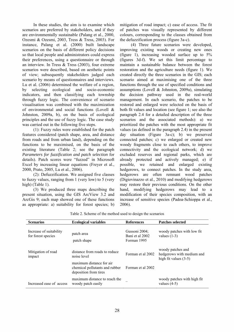
Table 2. Scheme of the method used to design the scenarios
Scenarios Ecological variables References Patches selected Increase of suitability for forest species
patch area
Gussoni 2004; Bani et al 2002
woody patches with low fit values (1-3)
patch shape Forman 1995
Mitigation of road impact
distance from roads to reduce noise level
Forman et al 2002
woody patches and hedgerows with medium and high fit values (3-5)
maximum distance for air chemical pollutants and rubber deposition from tires
Forman et al 2002
Increased ease of access
maximum distance to reach the woody patch easily
–
woody patches with high fit values (4-5)
28
(5) Finally, each of the three future scenarios was evaluated against current situation, and then compared with the rules of the other two scenarios. In this comparison, the fit of each patch improved for a function (e.g., forest species increase), was evaluated using the rules of the other two functions (e.g., ease of access and mitigation of road impact: figure 4). This allowed to evaluate how managing the landscape for one function can help to accomplish also the other functions, and therefore provided insights on the interplay among the functions.
2.4 Parameters for fuzzification and patch
selection Increase of suitability for forest species. The
aim of this scenario is to promote the presence of several forest species living in fragmented landscapes. We used four species as surrogates of the biodiversity of woodland vertebrates (Caro & O'Doherty, 1999), which are considered as biodiversity indicators and umbrella / focal species (Bright et al., 1996, Bani, 2002). For this scenario, two variables were considered: a) the minimum area needed for the forest animals selected to survive and b) patch shape.
a) The species selected were: Muscardinus avellanarius (dormouse) with 11 ha as minimum patch area in the study region (Gussoni, 2004) and a group of three birds: Dendrocopos major (great spotted woodpecker), Picus viridis (green woodpecker) and Sitta europaea (nuthatch); with 25 ha as minimum area in the study region (Bani, 2002). These vertebrates were chosen because they are considered forest indicators in man dominated landscapes, and data on their patch area requirements are available (Bani, 2002, Lorenzetti & Battisti, 2007).
b) Patch shape influences forest species mostly because of the negative edge effect and the progressive reduction of the core area (Forman, 1995). We assumed that a woody fragment close to the isodiametric shape would have a higher suitability for forest species (Diamond, 1975, Margules & Pressey, 2000), while an elongated shape would promote weedy and edge species (Laurance & Yensen, 1991, Honnay et al., 2005). For patch shape, the index used was γ = (2 √ πA) / P (Forman, 1995). Values close to 0 mean a elongated shape and those close to 1 mean an almost isodiametric shape, and therefore more suitable for core area conservation. For area, the range of fit (0.0-1.0) was used for patches with surface in the range of 11-25 ha. For shape, the range of fit (0.0-
1.0) was used for the range 0.5-0.8 (figure 2 a, b). Patches had two fit values of suitability for forest species (i.e., area and shape); per each patch, we used the highest of them to build the final scenario.
For the forest species suitability scenario, existing hedgerows and woody patches with “very low”, “low” and “medium” fit values (Classes 1-3 in Table 1) were selected to enlarge and connect fragments together.
Mitigation of road impact. Negative effects between roads and the surrounding landscape are connected with aerial pollution, noise, microclimate changes, habitat fragmentation (Singer & Beattie, 1986, Forman, 1995). These effects are stronger nearby the roads, while their intensity decreases far from roads (Forman & Deblinger, 2000). Vegetation barriers close to roads mitigate these impacts, because they partially adsorb both air pollution and noise disturbance (Forman et al., 2003). The variables chosen for the mitigation of road impacts were a) noise disturbance: 100 m from roads was taken as the maximum distance for reduction of noise level caused by motor vehicles to 60 dB and b) materials involved in chemical pollution: 40 m from roads was taken as the maximum distance for chemical pollutants and rubber deposition from tires (Forman et al., 2003). We therefore defined the range of fit (1.0-0.0) for distances ranging from 40 to 100 m to the nearest road (figure 2c). For the mitigation of road impact scenario, we selected also existing hedgerows to create new woods, because there were not many woods near roads included in Classes 3-5 (Table 1). Increased ease of access. For this scenario, we enlarged woods in the surroundings of the city, to allow people to reach the woody patches easily by bicycle or on foot, and 1 km was considered to be the maximum distance from the town outskirts. We defined a range of fit (1.0-0.0) for distances from 500 to 1000 m (figure 2d), assuming 5 ha as the minimum area for existing woods. For the increased ease of access scenario, woody patches with a “high” fit value in the current situation (Classes 4 or 5, Table 1) were chosen for enlargement; the smallest patches that would have required excessive enlargement were not included.
3. RESULTS
Below we report the hypothetical future wood cover increase, following the three different scenarios (see also Table 3).
a) Increase of suitability for forest species. 52.5% of woody patches currently present “very low” or “low” fit values, 9.5% “medium” values and
29
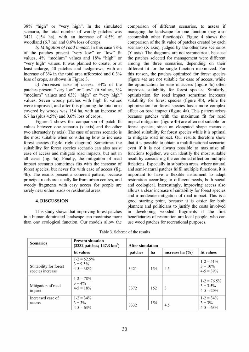
30
38% “high” or “very high”. In the simulated scenario, the total number of woody patches was 3421 (154 ha), with an increase of 4.5% of woodland (6.7 ha) and 0.6% loss of crops.
b) Mitigation of road impact. In this case 78% of the patches present “very low” or “low” fit values, 4% “medium” values and 18% “high” or “very high” values. It was planned to create, or at least enlarge, 40 patches and hedgerows, with an increase of 3% in the total area afforested and 0.3% loss of crops, as shown in Figure 3.
c) Increased ease of access. 34% of the patches present “very low” or “low” fit values, 3% “medium” values and 63% “high” or “very high” values. Seven woody patches with high fit values were improved, and after this planning the total area covered by woods was 154 ha, with an increase of 6.7 ha (plus 4.5%) and 0.6% loss of crops.
Figure 4 shows the comparison of patch fit values between one scenario (x axis) and the other two alternately (y axis). The ease of access scenario is the most suitable when considering how to increase forest species (fig.4c, right diagram). Sometimes the suitability for forest species scenario can also assist ease of access and mitigate road impacts, but not in all cases (fig. 4a). Finally, the mitigation of road impact scenario sometimes fits with the increase of forest species, but never fits with ease of access (fig. 4b). The results present a coherent pattern, because principal roads are usually far from urban centres, and woody fragments with easy access for people are rarely near either roads or residential areas.
4. DISCUSSION
This study shows that improving forest patches in a human dominated landscape can maximise more than one ecological function. Our models allow the
comparison of different scenarios, to assess if managing the landscape for one function may also accomplish other function(s). Figure 4 shows the comparison of the fit value of patches created by each scenario (X axis), judged by the other two scenarios (Y axis). The diagrams are not symmetrical, because the patches selected for management were different among the three scenarios, depending on their different fit for the single function maximized. For this reason, the patches optimized for forest species (figure 4a) are not suitable for ease of access, while the optimization for ease of access (figure 4c) often improves suitability for forest species. Similarly, optimization for road impact sometime increases suitability for forest species (figure 4b), while the optimization for forest species has a more complex effect on road impact (figure 4a). This pattern arises because patches with the maximum fit for road impact mitigation (figure 4b) are often not suitable for forest species, since an elongated shape means a limited suitability for forest species while it is optimal to mitigate road impact. Our results therefore show that it is possible to obtain a multifunctional scenario; even if it is not always possible to maximize all functions together, we can identify the most suitable result by considering the combined effect on multiple functions. Especially in suburban areas, where natural and semi-natural patches fulfil multiple functions, it is important to have a flexible instrument to adapt restoration according to different needs, both social and ecological. Interestingly, improving access also allows a clear increase of suitability for forest species and a moderate mitigation of road impact. This is a good starting point, because it is easier for both planners and politicians to justify the costs involved in developing wooded fragments if the first beneficiaries of restoration are local people, who can use wood patches for recreational purposes.
Table 3. Scheme of the results
Scenarios Present situation (3332 patches; 147.3 km2)
After simulation
fit values patches ha increase ha (%) fit values
Suitability for forest species increase
1-2 = 52.5% 3 = 9.5% 4-5 = 38%
3421
154
4.5
1-2 = 51% 3 = 10% 4-5 = 39%
Mitigation of road impact
1-2 = 78% 3 = 4% 4-5 = 18%
3372
152
3
1-2 = 76.5% 3 = 3.5% 4-5 = 20%
Increased ease of access
1-2 = 34% 3 = 3% 4-5 = 63%
3332
154
4.5
1-2 = 34% 3 = 3% 4-5 = 63%
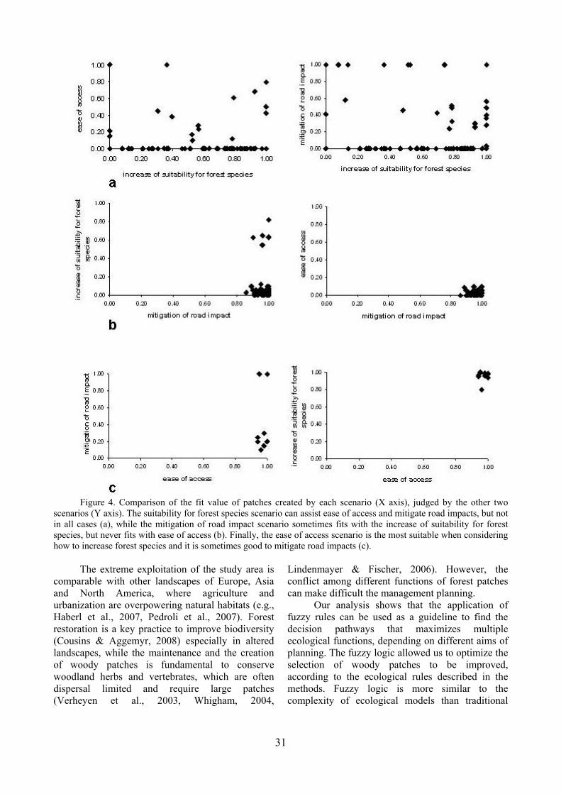
Figure 4. Comparison of the fit value of patches created by each scenario (X axis), judged by the other two
scenarios (Y axis). The suitability for forest species scenario can assist ease of access and mitigate road impacts, but not in all cases (a), while the mitigation of road impact scenario sometimes fits with the increase of suitability for forest species, but never fits with ease of access (b). Finally, the ease of access scenario is the most suitable when considering how to increase forest species and it is sometimes good to mitigate road impacts (c).
The extreme exploitation of the study area is comparable with other landscapes of Europe, Asia and North America, where agriculture and urbanization are overpowering natural habitats (e.g., Haberl et al., 2007, Pedroli et al., 2007). Forest restoration is a key practice to improve biodiversity (Cousins & Aggemyr, 2008) especially in altered landscapes, while the maintenance and the creation of woody patches is fundamental to conserve woodland herbs and vertebrates, which are often dispersal limited and require large patches (Verheyen et al., 2003, Whigham, 2004,
Lindenmayer & Fischer, 2006). However, the conflict among different functions of forest patches can make difficult the management planning.
Our analysis shows that the application of fuzzy rules can be used as a guideline to find the decision pathways that maximizes multiple ecological functions, depending on different aims of planning. The fuzzy logic allowed us to optimize the selection of woody patches to be improved, according to the ecological rules described in the methods. Fuzzy logic is more similar to the complexity of ecological models than traditional
31

logic (Freyer et al., 2000, Enea & Salemi, 2001, Adriaenssens et al., 2004), even though it requires stringent definition of the membership function rules, based on the available information. For this reason, in the development of scenarios, we used the data available from the scientific literature.
In the suitability for forest species scenario (figure 3 a-d), our goal was promoting the habitat for a selected group of woodland vertebrates, and we applied the existing information to identify the patches to be managed, optimizing resource allocation. Working on the whole biodiversity is a very time consuming task; for this reason, we focused on a set of vertebrates that are considered umbrella species or biodiversity indicators for forest communities (Bani, 2002, Gussoni, 2004, Lorenzetti & Battisti, 2006). This study focused on animal communities, because information on patch area requirements for plants are sparse. However, in human dominated landscapes plant and animal biodiversity are often related, therefore our analysis can provide important insights also for taxa not specifically targeted by this study (Sauberer et al., 2004).
5. CONCLUSIONS
Both the European Union and the local
administrations strongly encourage the creation of green belts around the most important urbanised areas. This strategy is important for the maintenance of both the strongly compromised natural ecosystems and human welfare. The extreme human exploitation in Northern Italy has caused the decrease of the natural habitats. Especially in lowland areas, vegetation is currently reduced to small woody fragments near the water courses, or to small ponds and hedgerows. Despite their reduced surfaces, these areas have a key role for the maintenance of biodiversity and landscape connectivity. Small woodlands harbour forest herbs, threatened vertebrates, and can act as stepping stones if they are nonisolated and close to mature forests (Jacquemyn et al., 2001, 2003, Ficetola et al., 2009). Moreover, these areas can also play other roles, such as reducing the negative impacts of intensive agriculture on the landscape, decreasing the negative wind impact on the field edges, enhancing the CO2 absorption and mitigating road disturbance and pollution (Burel & Baudry, 1995, Forman et al., 2003, Falloon et al., 2004).
In the last years, ongoing management projects are increasing the extent of forested areas and hedgerows as boundaries between crop fields, in collaboration with farmers. The Lombardy
environmental policies are promoting the enhancement and restoration of agro-forested structures surrounding the cities with several projects, such as the “10 large forests for the plains”, the “Green Ecosystem” and the “Green Rays” programs (Pedroli et al., 2007). Furthermore, citizens are increasingly conscious of the issues of deforestation and loss of natural habitats, and there is raising awareness that the availability of natural areas outside the city can improve life quality (Christ et al., 2003). Landscape ecology is becoming progressively more involved in the comparison of different management practices for the planning of future scenarios. The combination of ecological and recreational functions of landscape can increase the effectiveness and the social acceptance of management, and improve the options available to decision makers. ACNOWLEDGEMENTS
We thank Freda Bunce for improving the English. PD was funded by a grant of the Milano Province, Environmental Section, on conservation in agro-forested settings; GFF was funded by a post-doctoral fellowship of the Università degli Studi di Milano Bicocca. REFERENCES Adriaenssens V., De Baets B., Goethals P.L.M., De
Pauw N., 2004. Fuzzy rule-based models for decision support in ecosystem management, Science of the Total Environment, 319, 1-12.
Bani L., Baietto, M., Bottoni, L., Massa, R., 2002. The use of focal species in designing a habitat network for a lowland area of Lombardy, Italy, Conservation Biology, 16, 826-831.
Barros L.C., Bassanezi R.C., Tonelli P.A., 2000. Fuzzy modelling in population dynamics, Ecological Modelling, 128, 27-33.
Bolliger J., Kienast F., Soliva R., Rutherford G., 2007. Spatial sensitivity of species habitat patterns to scenarios of land use change (Switzerland), Landscape Ecology, 22, 773-789.
Bright P.W., Morris P.A., Wiles N.J., 1996. Effects of weather and season on the summer activity of dormice Muscardinus avellanarius, Journal of Zoology, 238, 521-530.
Burel F., Baudry J., 1995. Social, aesthetic and ecological aspects of hedgerows in rural landscapes as a framework for greenways, Landscape and Urban Planning, 33, 327-340.
Caro T.M., O'Doherty C., 1999. On the use of surrogate species in conservation biology, Conservation Biology, 13, 805-814.
Chincarini M., Andreis C., 2005. Filari nei paesaggi agricoli: variabili strutturali più influenti sul contenuto in specie erbacee nemorali indicatrici di qualità, Informatore Botanico Italiano, 37, 200-201.
32
Christ C., Hillel O., Matus S., Sweeting J., 2003. Tourism and biodiversity. Conservation International, Washinghton DC.
Cousins S.A.O., Aggemyr E., 2008. The influence of field shape, area and surrounding landscape an plant species richness in grazed ex-fields, Biological Conservation, 141, 126-135.
Diamond J.D., 1975. The island dilemma: lessons of modern biogeographic studies for the design of natural reserves, Biological Conservation, 7, 129-146.
Digiovinazzo P., Ficetola G.F., Bottoni L., Andreis C., Padoa-Schioppa E., 2010. Ecological thresholds in herb communities for the management of suburban fragmented forests, Forest Ecology and Management, 259, 343–349.
Ducey M.J., Larson B.C., 1999. A fuzzy set approach to the problem of sustainability, Forest Ecology and Management, 155, 29-40.
Enea M., Salemi G., 2001. Fuzzy approach to the environmental impact evaluation, Ecological Modelling, 136, 131-147.
Fahrig L., 2003. Effects of habitat fragmentation on biodiversity, Annual review of Ecology Evolution and Systematics, 34, 487-515.
Falloon P., Powlson D., Smith P., 2004. Managing field margins for biodiversity and carbon sequestration: a Great Britain case study, Soil Use and Management, 20, 240-247.
Feoli E., Zerihun W., 2000. Fuzzy set analysis of the Ethiopian rift valley vegetation in relation to anthropogenic influences, Plant Ecology, 147, 219-225.
Ficetola G.F., De Bernardi F., 2004. Amphibians in an human-dominated landscape: the community structure is related to habitat features and isolation, Biological Conservation, 119, 219-230.
Ficetola G.F., Padoa-Schioppa E., De Bernardi F., 2009. Influence of landscape elements in riparian buffers on the conservation of semiaquatic amphibians, Conservation Biology, 23, 114-123.
Forman R.T.T., 1995. Land Mosaics – the ecology of landscapes and regions. Cambridge University Press, Cambridge. p. 632.
Forman R.T.T., Deblinger R.D., 2000. The ecological road-effect zone of a Massachusetts (USA) suburban highway, Conservation Biology, 14, 36-46.
Forman R.T.T., Reineking B., Hersperger A.M., 2002. Road traffic and nearby grassland bird patterns in suburbanizing landscape, Environmental Management, 29, 782-800.
Forman R.T.T., Sperling D., Bissonette J.A., Clevenger A.P., Cutshall C.D., Dale V.H., Fahrig L., France R., Goldman C. R., Heanue K., Jones J. A., Swanson F. J., Turrentine T. and Winter T. C., 2003. Road ecology: Science and Solutions. Island Press, Washington, DC. p. 481.
Freyer B., Reisner Y., Zuberbuhler D., 2000. Potential
impact model to assess agricultural pressure to landscape ecological functions, Ecological Modelling, 130, 121-129
Guisan A., Thuiller W., 2005. Predicting species distribution: offering more than simple habitat models, Ecology Letters, 8, 993-1009.
Gussoni S.E., 2004. Rete ecologica e fauna terrestre. Studi e progetti. Guerini e Associati, Milano. 250 pp.
Haberl H., Erb K.H., Krausmann F., Gaube V., Bondeau A., Plutzar C., Gingrich S., Lucht W., Fischer-Kowalski M., 2007. Quantifying and mapping the human appropriation of net primary production in earth's terrestrial ecosystems, Proceedings of the National Academy of Sciences of the United States of America, 104, 12942-12945.
Hill K.E., Binford M.W., 2002. The Role of Category Definition in Habitat Models: Practical and Logical Limitations of Using Boolean, Indexed, Probabilistic and Fuzzy Categories, In: Predicting Species Occurrences. Issues of Accuracy and Scale (eds. Scott J.M., Heglund P.J. & Morrison M.L.). Island Press. p. 97-106.
Honnay O., Jacquemyn H., Bossuyt B., Hermy M., 2005. Forest fragmentation effects on patch occupancy and population viability of herbaceous plant species, New Phytologist, 166, 723-736.
Jacquemyn H., Butaye J., Hermy M., 2001. Forest plant species richness in small, fragmented mixed deciduous forest patches: the role of area, time and dispersal limitation, Journal of Biogeography, 28, 801-812.
Jacquemyn H., Butaye J., Hermy M., 2003. Impacts of restored patch density and distance from natural forests on colonization success, Restoration Ecology, 11, 417-423.
Krysanova V., Haberlandt U., 2002. Assessment of nitrogen leaching from arable land in large river basins Part I. Simulation experiments using a process-based model, Ecological Modelling, 150, 255-275.
Lange E., Hehl-Lange S., Brewer M.J., 2008. Scenario-visualization for the assessment of perceived green space qualities at the urban-rural fringe, Journal of Environmental Management, 89, 245-256.
Laurance W.F., Yensen E., 1991. Predicting the impacts of edge effects in fragmented habitats, Biological Conservation, 55, 77-92.
Lindenmayer D.B., Fischer J., 2006. Habitat fragmentation and landscape change. Island Press, Washington, DC. p. 352.
Lorenzetti E., Battisti C., 2006. Area as component of habitat fragmentation: Corroborating its role in breeding bird communities and guilds of oak wood fragments in Central Italy, Revue d'Ecologie (Terre Vie), 61, 53-68.
Lorenzetti E., Battisti C., 2007. Nature reserve selection on forest fragments in a suburban landscape (Rome, central Italy): Indications from a set of
33
34
avian species, Landscape Research, 32, 57-78. Lovell S.T., Johnston D.M., 2009a. Creating
multifunctional landscapes: how can the field of ecology inform the design of the landscape?, Frontiers in Ecology and the Environment, 7, 212-220.
Lovell S.T., Johnston D.M., 2009b. Designing landscapes for performance based on emerging principles in landscape ecology, Ecology and Society, 14(1), 44.
Lu Y.H., Fu B.J., Chen L.D., Ouyang Z.Y., Xu J.Y., 2006. Resolving the conflicts between biodiversity conservation and socioeconomic development in China: Fuzzy clustering approach, Biodiversity and Conservation, 15, 2813-2827.
Margules C.R., Pressey R.L., 2000. Systematic conservation planning, Nature, 405, 243-253.
Moser B., Jaeger J.A.G., Tappeiner U., Tasser E., Eiselt B., 2007. Modification of the effective mesh size for measuring landscape fragmentation to solve the boundary problem, Landscape Ecology, 22, 447-459.
Ozesmi U., Ozesmi S., 2003. A participatory approach to ecosystem conservation: Fuzzy cognitive maps and stakeholder group analysis in Uluabat Lake, Turkey, Environmental Management, 31, 518-531.
Padoa-Schioppa E., Baietto M., Massa R., Bottoni L., 2006. Bird communities as bioindicators: The focal species concept in agricultural landscapes, Ecological Indicators, 6, 83-93.
Palang H., Alumae H., Mander U., 2000. Holistic aspects in landscape development: a scenario approach, Landscape and Urban Planning, 50, 85-94.
Pedroli B., Van Doorn A., De Blust G., Paracchini M.L., Wascher D., Bunce F., 2007. Europe’s living landscapes. Essays exploring our identity in the countryside. Wageningen/KNNV Publishing, Zeist. p. 432.
Prato T., 2005. A fuzzy logic approach for evaluating ecosystem sustainability, Ecological Modelling, 187, 361-368.
Roy V., de Blois S., 2008. Evaluating hedgerow corridors for the conservation of native forest herb diversity, Biological Conservation, 141, 298-307.
Sangalli A., 1998. The importance of being fuzzy and other insights from the border between math and
computers. Princeton University Press, Princeton. p. 208.
Santelmann M.V., White D., Freemark K., Nassauer J.I., Eilers J.M., Vache K.B., Danielson B.J., Corry R.C., Clark M.E., Polasky S., Cruse R.M., Sifneos J., Rustigian H., Coiner C., Wu J., Debinski D., 2004. Assessing alternative futures for agriculture in Iowa, USA, Landscape Ecology, 19, 357-374.
Sauberer N., Zulka K.P., Abensperg-Traun, M., Berg, H.-M., Bieringer, G., Milasowszky, N., Moser, D., Plutzar, C., Pollheimer, M., Storch, C., Trostl, R., Zechmeister, H., Grabherr G., 2004. Surrogate taxa for biodiversity in agricultural landscapes of eastern Austria, Biological Conservation, 117, 181-190.
Shepard B.R., 2005. Quantifying environmental impact assessments using fuzzy logic Springer, New York. p. 264.
Singer F.J., Beattie J.B., 1986. The controlled traffic system and associated wildlife responses in Denali National Park, Arctic, 39, 195-203.
Sitzia T., 2007. Hedgerows as corridors for woodland plants: a test on the Po Plain, northern Italy, Plant Ecology, 188, 235-252.
Swaffield S.R., Fairweather J.R., 1996. Investigation of attitudes towards the effects of land use change using image editing and Q sort method, Landscape and Urban Planning, 35, 213-230.
Tress B., Tress G., 2003. Scenario visualisation for participatory landscape planning - a study from Denmark, Landscape and Urban Planning, 64, 161-178.
Van Den Berg L.M., Veeneklaas F.R., 1995. Scenario building: art, craft or just a fashionable whim?, In: Scenario Studies for the Rural Environment (eds. Schoute J.F.T., Finke P.A., F.R. V. & Wolfert H.P.) Kluwer Academic Publishers, Dordrecht. p. 11-13.
Verheyen K., Bossuyt B., Honnay O., Hermy M., 2003. Herbaceous plant community structure of ancient and recent forests in two contrasting forest types, Basic and Applied Ecology, 4, 537-546.
Whigham D.E., 2004. Ecology of woodland herbs in temperate deciduous forests, Annual review of Ecology Evolution and Systematics, 35, 583-621.
Received at: 14. 05. 2010 Revised at: 06. 09. 2010 Accepted for publication at: 07. 09. 2010 Published online at: 08. 09. 2010