satellite ocean color remote sensing for ocean coastal and
TRANSCRIPT
Menghua Wang, NOAA/NESDIS/STAR
Satellite Ocean Color Remote Sensing for Ocean Coastal and Inland Waters
Menghua WangNOAA/NESDIS/STAR
E/RA3, Room 102, 5200 Auth Rd. Camp Springs, MD 20746, USA
STAR Seminar WWW/Room 707, May 29, 2009
Support from the Research Group:Drs. Wei Shi and Hao Zhang, CIRA.Dr. Seung-Hyun Son, IMSG.Dr. Xiaoming Liu, SP Systems, Inc.
Works are supported by NOAA and NASA funding and grants.
1

Menghua Wang, NOAA/NESDIS/STARChesapeake BayLake Taihu 2
Menghua Wang, NOAA/NESDIS/STAR
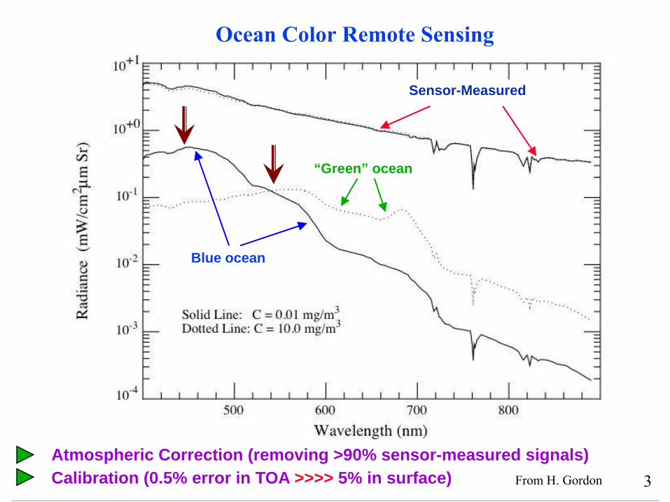
Ocean Color Remote Sensing
Sensor-Measured
Blue ocean
“Green” ocean
From H. Gordon
Atmospheric Correction (removing >90% sensor-measured signals)Calibration (0.5% error in TOA >>>> 5% in surface) 3
Menghua Wang, NOAA/NESDIS/STAR
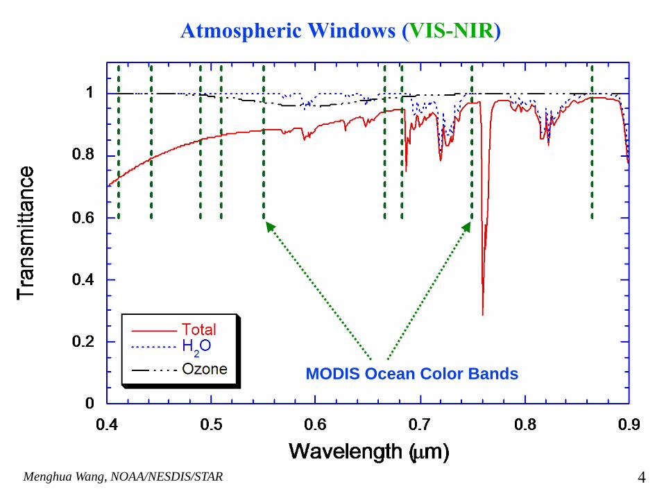
Atmospheric Windows (VIS-NIR)
MODIS Ocean Color Bands
4
Menghua Wang, NOAA/NESDIS/STAR
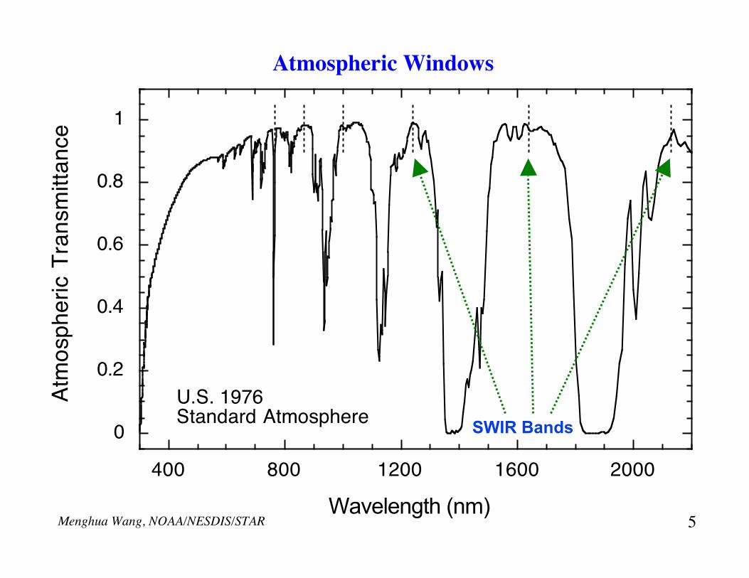
Atmospheric Windows
0
0.2
0.4
0.6
0.8
1
400 800 1200 1600 2000
Wavelength (nm)
U.S. 1976 Standard Atmosphere
Atm
osp
he
ric T
ran
sm
itta
nce
SWIR Bands
5

Menghua Wang, NOAA/NESDIS/STAR
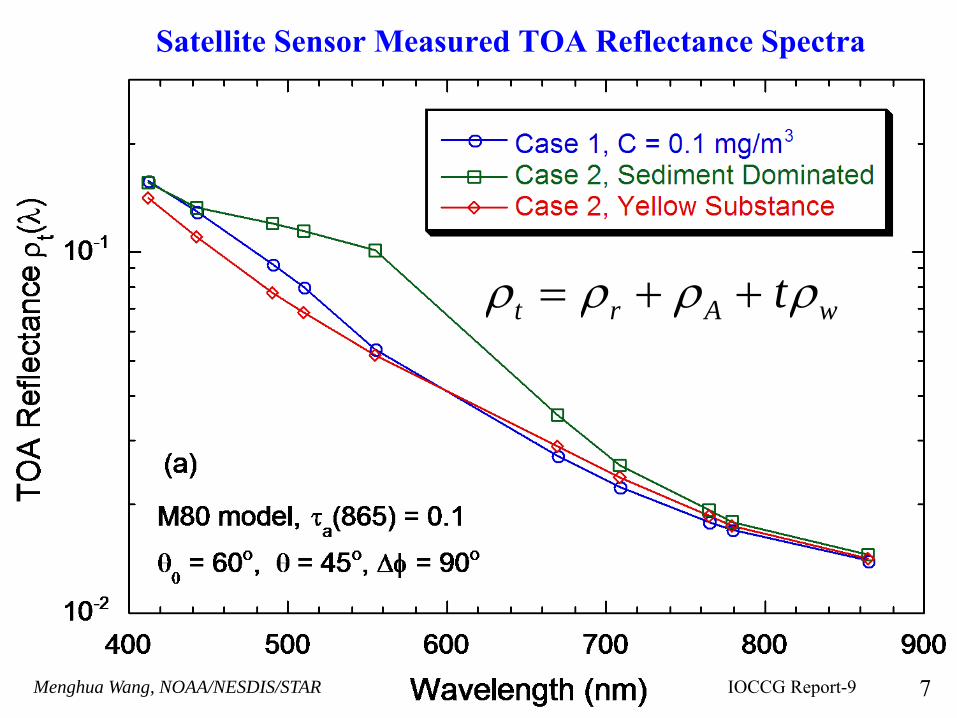
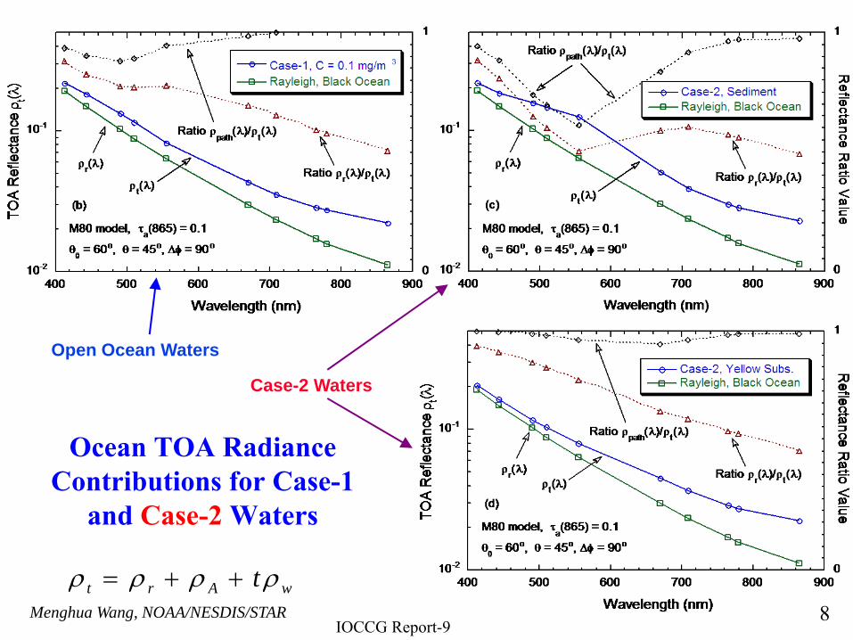
Ocean Contributions: Case-1 Waters
Ocean Contributions: Case-2 Waters
IOCCG Report-96
Menghua Wang, NOAA/NESDIS/STAR
Satellite Sensor Measured TOA Reflectance Spectra
IOCCG Report-9 7
ρt = ρr + ρA + tρw
Menghua Wang, NOAA/NESDIS/STAR
Ocean TOA Radiance Contributions for Case-1
and Case-2 Waters
Open Ocean Waters
Case-2 Waters
IOCCG Report-98
ρ t = ρ r + ρ A + tρ w
Menghua Wang, NOAA/NESDIS/STAR
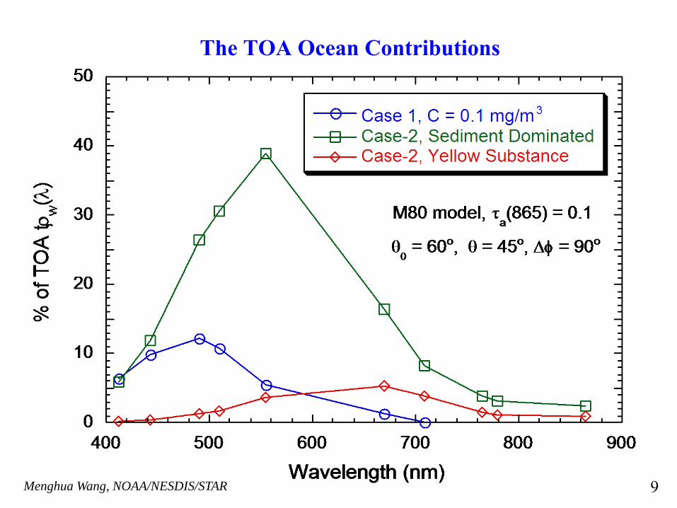
The TOA Ocean Contributions
9
Menghua Wang, NOAA/NESDIS/STAR
At satellite altitude ~90% of sensor-measured signal over ocean
comes from the atmosphere & surface!
• It is crucial to have accurate atmospheric correction and sensor calibrations.
• 0.5% error in atmospheric correction or calibrationcorresponds to possible of ~5% error in the derived ocean water-leaving radiance.
• We need ~0.1% sensor calibration accuracy.
10
Menghua Wang, NOAA/NESDIS/STAR
Ocean Color Remote Sensing: Derive the ocean water-leaving radiance spectra by accurately removing the atmospheric and surface effects.
Ocean properties can be derived from the ocean water-leaving radiance spectra.
11
Menghua Wang, NOAA/NESDIS/STAR
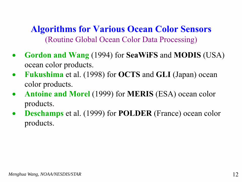
Algorithms for Various Ocean Color Sensors(Routine Global Ocean Color Data Processing)
• Gordon and Wang (1994) for SeaWiFS and MODIS (USA) ocean color products.
• Fukushima et al. (1998) for OCTS and GLI (Japan) ocean color products.
• Antoine and Morel (1999) for MERIS (ESA) ocean color products.
• Deschamps et al. (1999) for POLDER (France) ocean color products.
12
Menghua Wang, NOAA/NESDIS/STAR
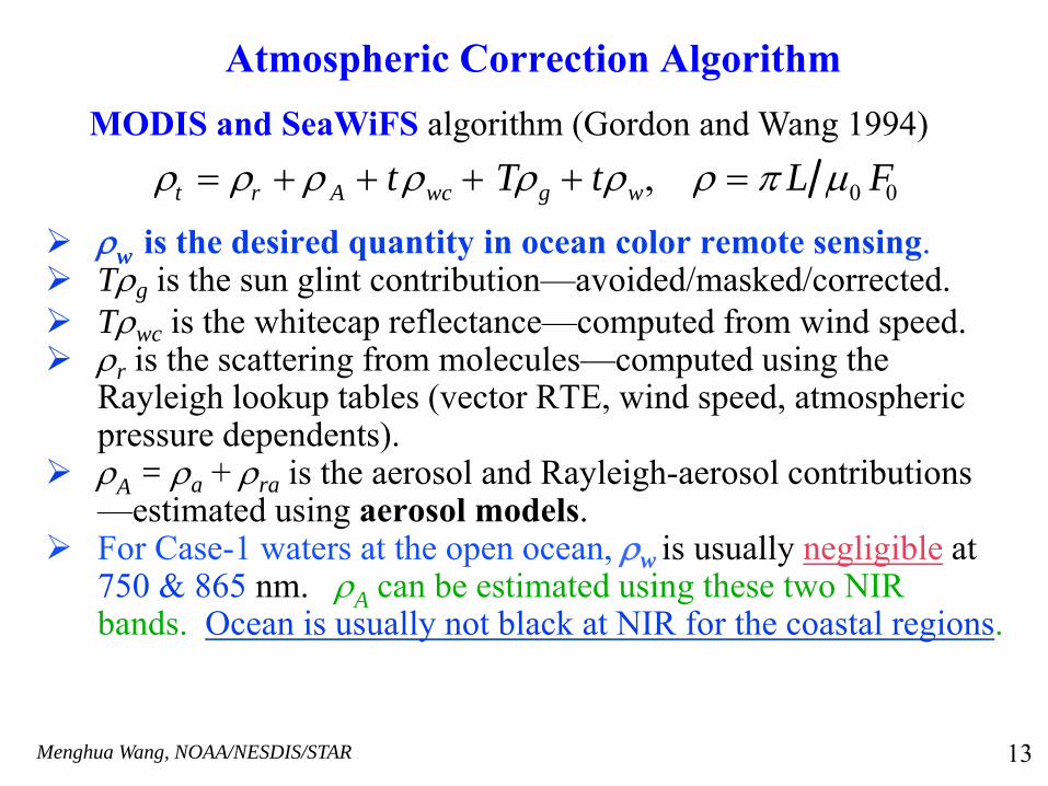
Atmospheric Correction Algorithm
ρw is the desired quantity in ocean color remote sensing.Tρg is the sun glint contribution—avoided/masked/corrected.Tρwc is the whitecap reflectance—computed from wind speed.ρr is the scattering from molecules—computed using the Rayleigh lookup tables (vector RTE, wind speed, atmospheric pressure dependents).ρA = ρa + ρra is the aerosol and Rayleigh-aerosol contributions —estimated using aerosol models. For Case-1 waters at the open ocean, ρw is usually negligible at750 & 865 nm. ρA can be estimated using these two NIR bands. Ocean is usually not black at NIR for the coastal regions.
ρt = ρr + ρ A + tρwc + Tρg + tρw, ρ = π L μ0 F0
MODIS and SeaWiFS algorithm (Gordon and Wang 1994)
13

Menghua Wang, NOAA/NESDIS/STAR
Characteristics of the Aerosol Models
Aerosol Model Single Scatteri ng Albedo a(865)
Asymmetry Parameter g
Ångström Exponent (510 , 865)
Oceanic = 1.0 0.724-0.840 -0.087~ -0.016
Maritime = 0.982-0.999 0.690-0.824 0.09-0.50
Coastal == 0.976-0.998 0.682-0.814 0.23-0.76
Tropospheric = 0.930-0.993 0.603-0.769 1.19-1.53
Urban = 0.603-0.942 0.634-0.778 0.85-1.14
Dust === 0.836-0.994 0.662-0.763 0.29-0.36
= Shettle and Fe nn (1979) aerosol models. ==Gordo n and Wang (1994) === Shettle (19 84) and Moulin et al. (2001).
14
Menghua Wang, NOAA/NESDIS/STAR
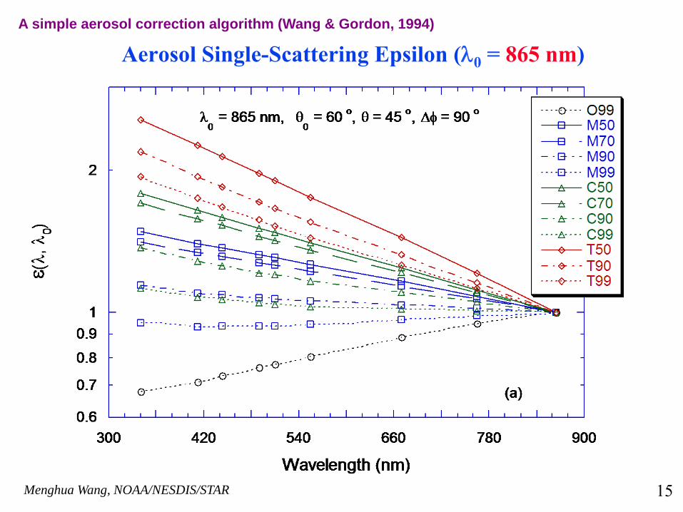
Aerosol Single-Scattering Epsilon (λ0 = 865 nm)A simple aerosol correction algorithm (Wang & Gordon, 1994)
15
Menghua Wang, NOAA/NESDIS/STAR
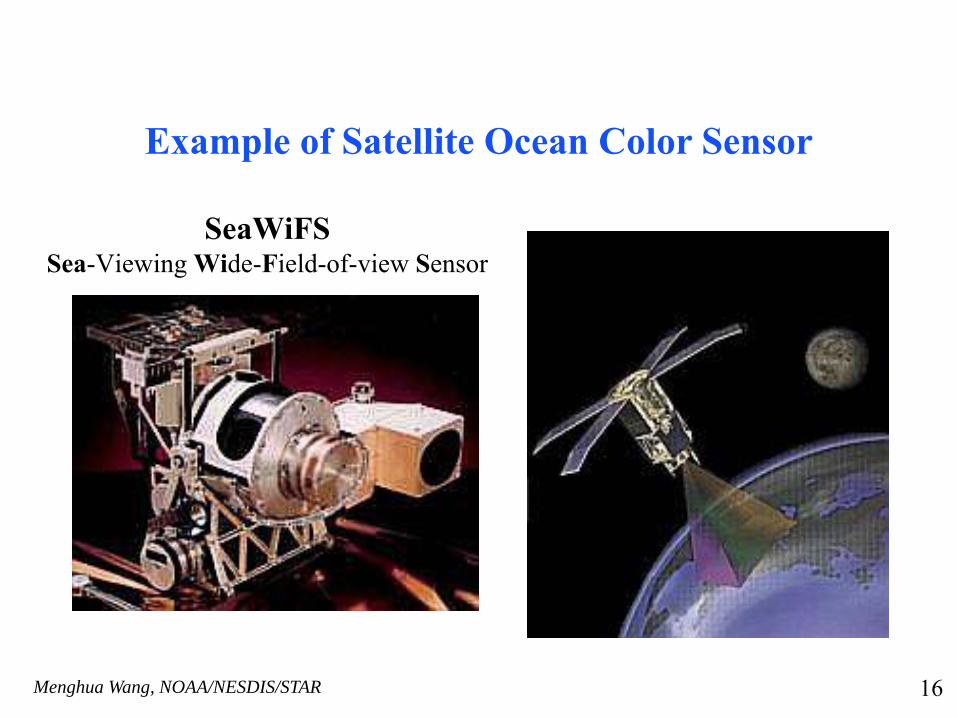
Example of Satellite Ocean Color Sensor
SeaWiFSSea-Viewing Wide-Field-of-view Sensor
16
Menghua Wang, NOAA/NESDIS/STAR
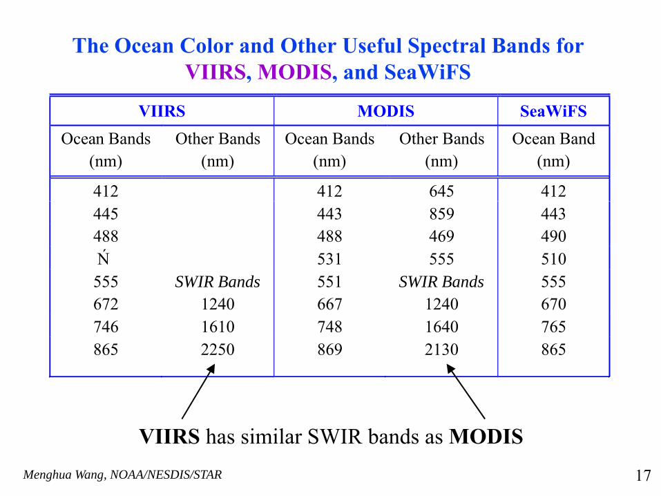
The Ocean Color and Other Useful Spectral Bands for VIIRS, MODIS, and SeaWiFS
VIIRS MODIS SeaWiFS Ocean Bands
(nm) Other Bands
(nm) Ocean Bands
(nm) Other Bands
(nm) Ocean Band
(nm)
412 412 645 412 445 443 859 443 488 488 469 490 Ń 531 555 510 555 SWIR Bands 551 SWIR Bands 555 672 1240 667 1240 670 746 1610 748 1640 765 865 2250 869 2130 865
VIIRS has similar SWIR bands as MODIS
17
Menghua Wang, NOAA/NESDIS/STAR
Some DetailsCalibrations: (a)Lunar calibration to remove sensor degradation, and (b) Vicarious calibration using the in situ MOBY data to set gains. It requires ~0.1% accuracy.Cloud Masking for SeaWiFS/MODIS: A simple reflectance threshold technique has been used, (ρt – ρr) ≤ 2.7% at the NIR (865 nm) band as being identified as clear sky. Surface effects: Ocean is assumed to be black at the NIR bands,modifications are made to account for the NIR ocean contributions at the NIR bands for productive oceans.A flat Fresnel-reflecting surface was used in RTE computations for aerosol lookup tables, while the Cox & Monk (1954) surface roughness model (wind dependent) was used for the Rayleigh lookup tables.Sun glint is avoided/masked and sun glint contamination is corrected using Wang and Bailey (2001). Aerosol Models: A set of 12 aerosol models from or derived from the work of Shettle and Fenn (1979) was used. Validations: SeaWiFS ocean color and aerosol products have been validated through the NASA SeaWiFS and SIMBIOS projects, and from in situ data acquired from various field campaigns in global open oceans.
18
Menghua Wang, NOAA/NESDIS/STAR
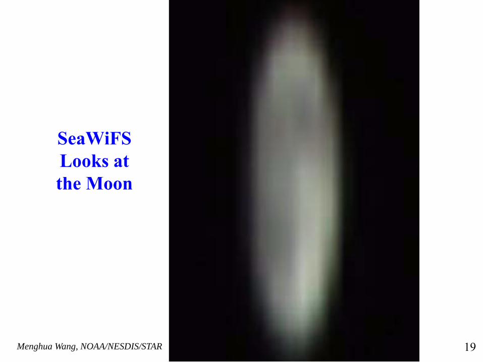
SeaWiFS Looks at the Moon
19

Menghua Wang, NOAA/NESDIS/STAR From http://oceancolor.gsfc.nasa.gov 20

Menghua Wang, NOAA/NESDIS/STAR
MOBY--Vicarious Calibration Facility for Ocean Color Satellite Sensors
From D. Clark
Radiance Measurement Accuracy ~ 5%
21
Menghua Wang, NOAA/NESDIS/STAR
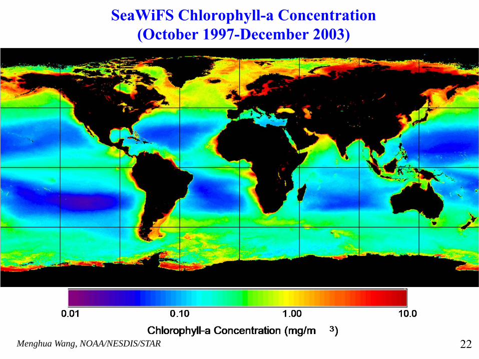
SeaWiFS Chlorophyll-a Concentration(October 1997-December 2003)
22
Menghua Wang, NOAA/NESDIS/STAR
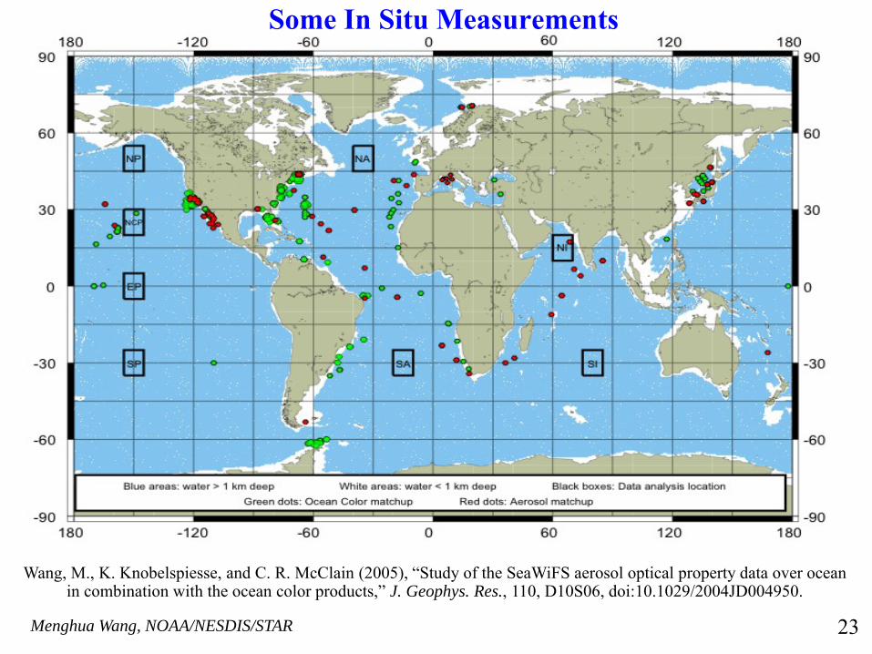
Wang, M., K. Knobelspiesse, and C. R. McClain (2005), “Study of the SeaWiFS aerosol optical property data over ocean in combination with the ocean color products,” J. Geophys. Res., 110, D10S06, doi:10.1029/2004JD004950.
23
Some In Situ Measurements
Menghua Wang, NOAA/NESDIS/STAR
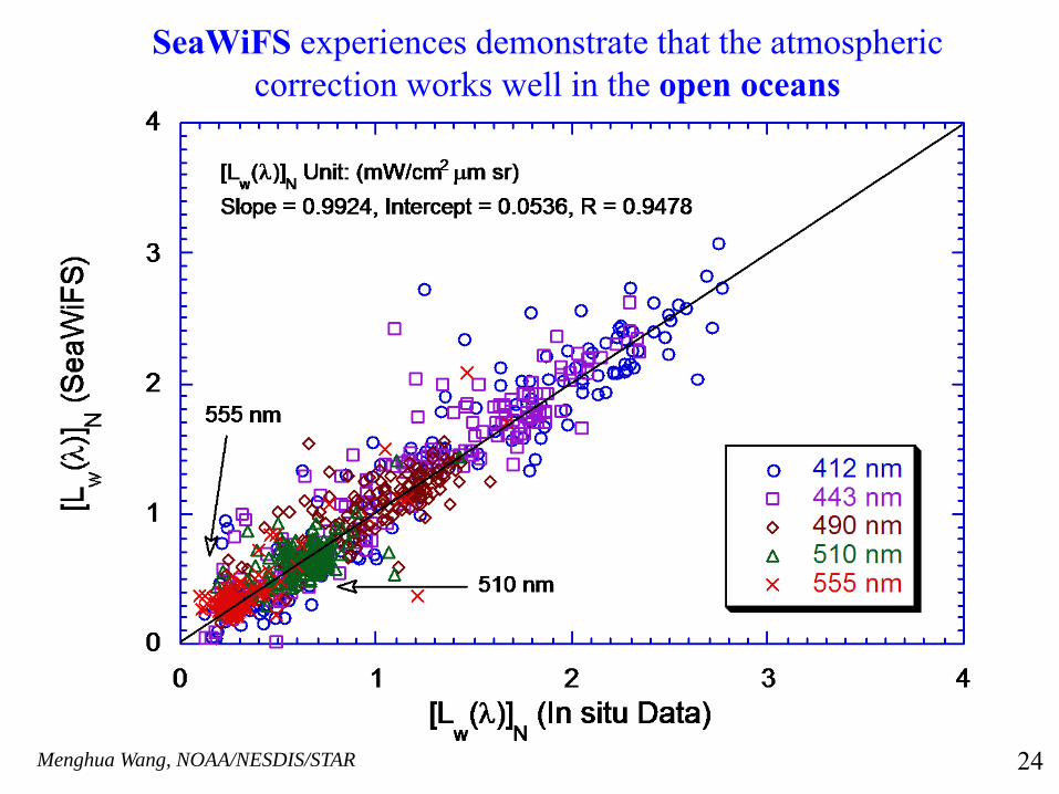
SeaWiFS experiences demonstrate that the atmospheric correction works well in the open oceans
24
Menghua Wang, NOAA/NESDIS/STAR
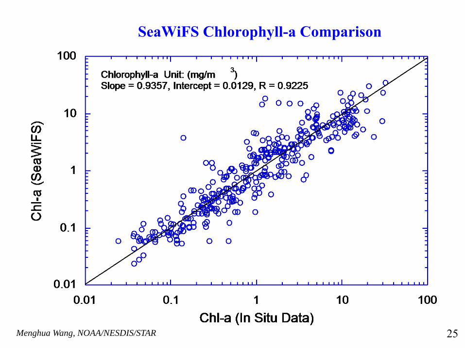
SeaWiFS Chlorophyll-a Comparison
25
Menghua Wang, NOAA/NESDIS/STAR
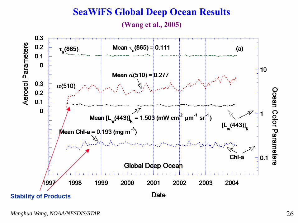
SeaWiFS Global Deep Ocean Results(Wang et al., 2005)
Stability of Products
26
Menghua Wang, NOAA/NESDIS/STAR
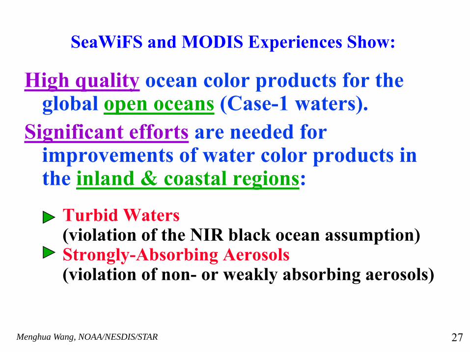
High quality ocean color products for the global open oceans (Case-1 waters).
Significant efforts are needed for improvements of water color products in the inland & coastal regions:
Turbid Waters (violation of the NIR black ocean assumption)Strongly-Absorbing Aerosols (violation of non- or weakly absorbing aerosols)
SeaWiFS and MODIS Experiences Show:
27
Menghua Wang, NOAA/NESDIS/STAR
Algorithm Developments for Productive Waters• Arnone et al. (1998) and Siegel et al. (2000) to account for the
NIR ocean contributions for SeaWiFS and MODIS NIR bands. • Hu et al. (1999) proposed an adjacent pixel method. • Gordon et al. (1997) and Chomko et al. (2003) the spectral
optimization algorithm.• Ruddick et al. (2000) for regional Case-2 algorithm using the
spatial homogeneity of the aerosol in a given area. • Lavender et al. (2004) regional bio-optical model (suspended
sediments) for SeaWiFS application. • Wang and Shi (2005) derived NIR ocean contributions using the
MODIS shortwave IR (SWIR) bands. • Doerffer et al. and others developed Artificial Neural Network for
coastal Case-2 waters (implemented for MERIS data processing). • Wang (2007) proposed atmospheric correction using the SWIR
bands for the turbid coastal waters.
28
Menghua Wang, NOAA/NESDIS/STAR
The NIR Ocean Contribution Modeling
Various investigators all sought to remove the NIR nLw(λ) contributions from the TOA NIR radiances, so that a “black pixel” could be provided to the Gordon and Wang (1994) type atmospheric correction:Siegel et al. (2000) used chlorophyll estimate to determine the NIR nLw(λ).Lavender et al. (2005) used a sediment estimate to determine the NIR nLw(λ).Ruddick et al. (2000) fixed the aerosol and backscatter type and then solved for both the NIR nLw(λ) and NIR aerosol reflectance simultaneously. Stumpf et al. (2003) used a bio-optical model for absorption coefficient at the red band and then used that with the red nLw(λ) to find the NIR nLw(λ).
29
Menghua Wang, NOAA/NESDIS/STAR
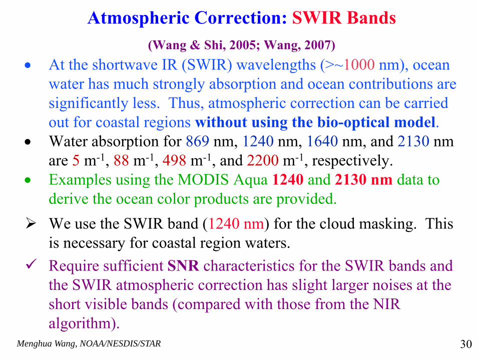
Atmospheric Correction: SWIR Bands(Wang & Shi, 2005; Wang, 2007)
• At the shortwave IR (SWIR) wavelengths (>~1000 nm), ocean water has much strongly absorption and ocean contributions are significantly less. Thus, atmospheric correction can be carried out for coastal regions without using the bio-optical model.
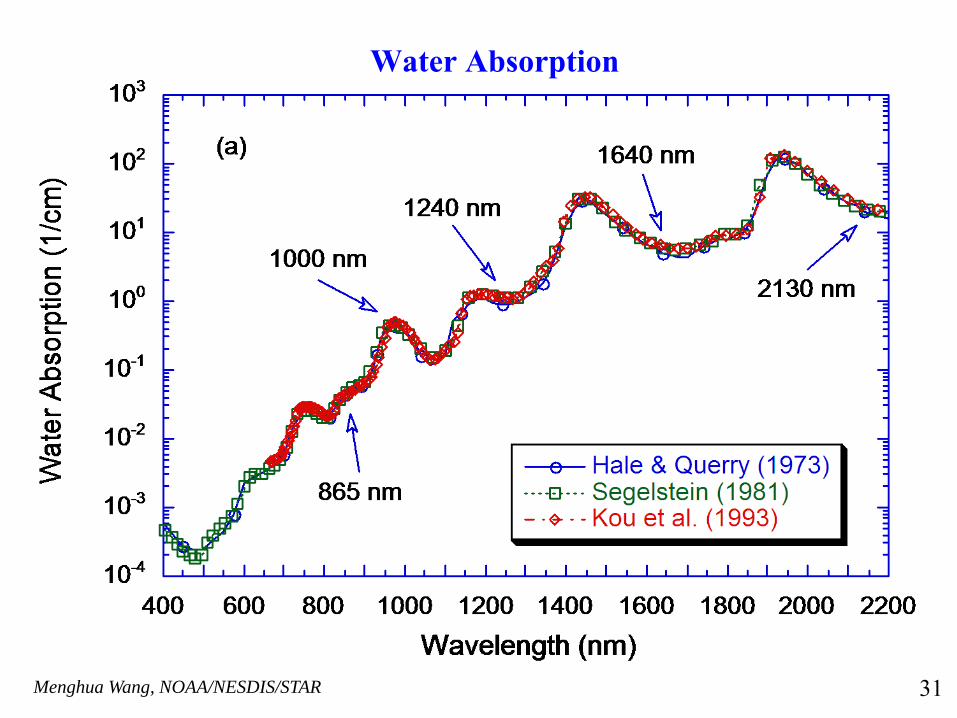
• Water absorption for 869 nm, 1240 nm, 1640 nm, and 2130 nm are 5 m-1, 88 m-1, 498 m-1, and 2200 m-1, respectively.
• Examples using the MODIS Aqua 1240 and 2130 nm data to derive the ocean color products are provided.We use the SWIR band (1240 nm) for the cloud masking. This is necessary for coastal region waters.Require sufficient SNR characteristics for the SWIR bands and the SWIR atmospheric correction has slight larger noises at the short visible bands (compared with those from the NIR algorithm).
30
Menghua Wang, NOAA/NESDIS/STAR
Water Absorption
31

Menghua Wang, NOAA/NESDIS/STAR
Aerosol Single-Scattering Epsilon (λ0 = 2130 nm)
32
Menghua Wang, NOAA/NESDIS/STAR
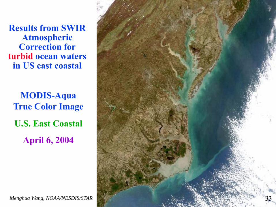
MODIS-Aqua True Color Image
U.S. East Coastal
April 6, 2004
Results from SWIR Atmospheric
Correction for turbid ocean waters
in US east coastal
33
Menghua Wang, NOAA/NESDIS/STAR
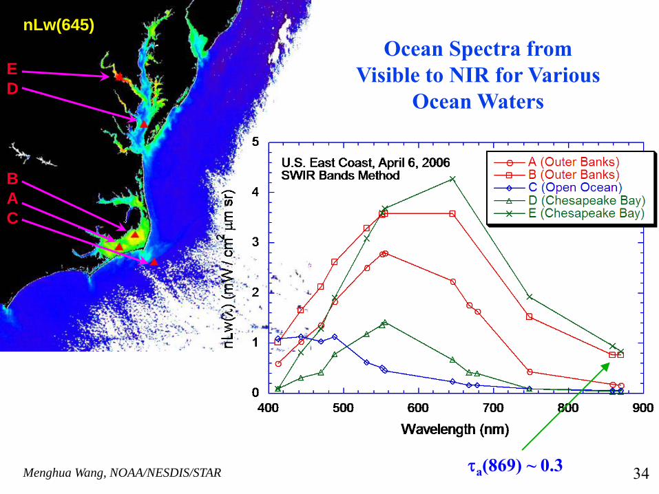
nLw(645)
BAC
E D
Ocean Spectra from Visible to NIR for Various
Ocean Waters
τa(869) ~ 0.3 34
Menghua Wang, NOAA/NESDIS/STAR
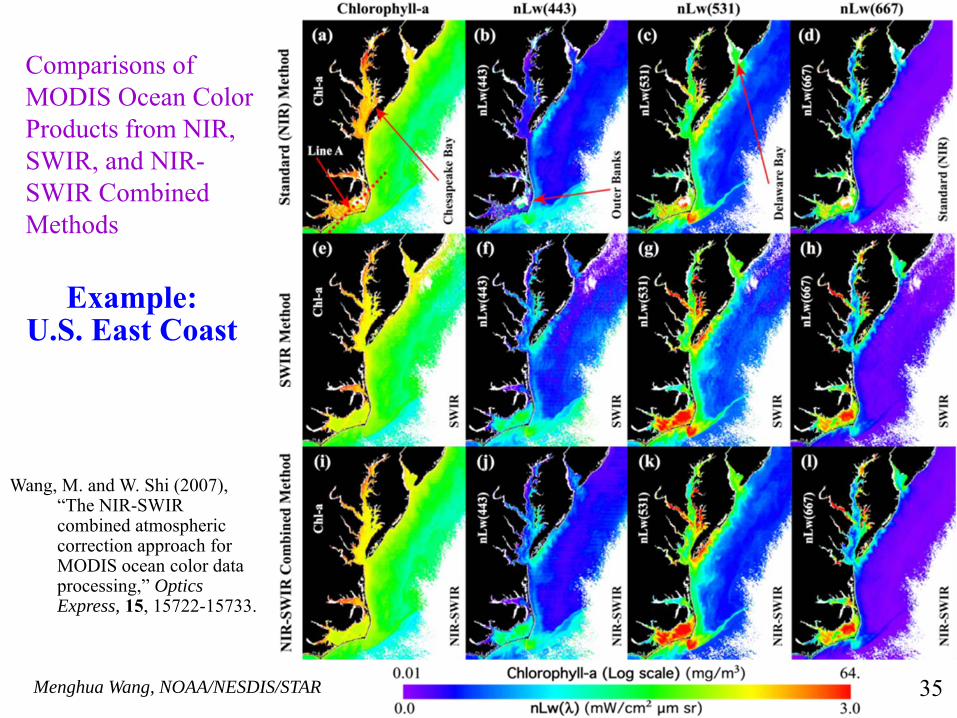
Example: U.S. East Coast
Comparisons of MODIS Ocean Color Products from NIR, SWIR, and NIR-SWIR Combined Methods
Wang, M. and W. Shi (2007), “The NIR-SWIR combined atmospheric correction approach for MODIS ocean color data processing,” Optics Express, 15, 15722-15733.
35
Menghua Wang, NOAA/NESDIS/STAR
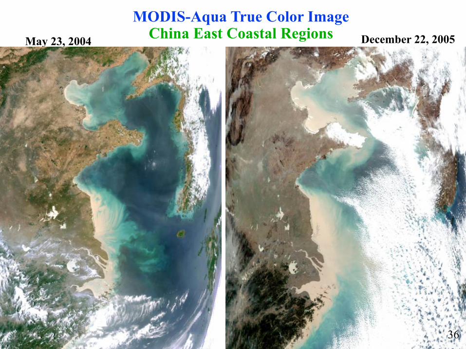
MODIS-Aqua True Color ImageChina East Coastal Regions December 22, 2005May 23, 2004
36
Menghua Wang, NOAA/NESDIS/STAR
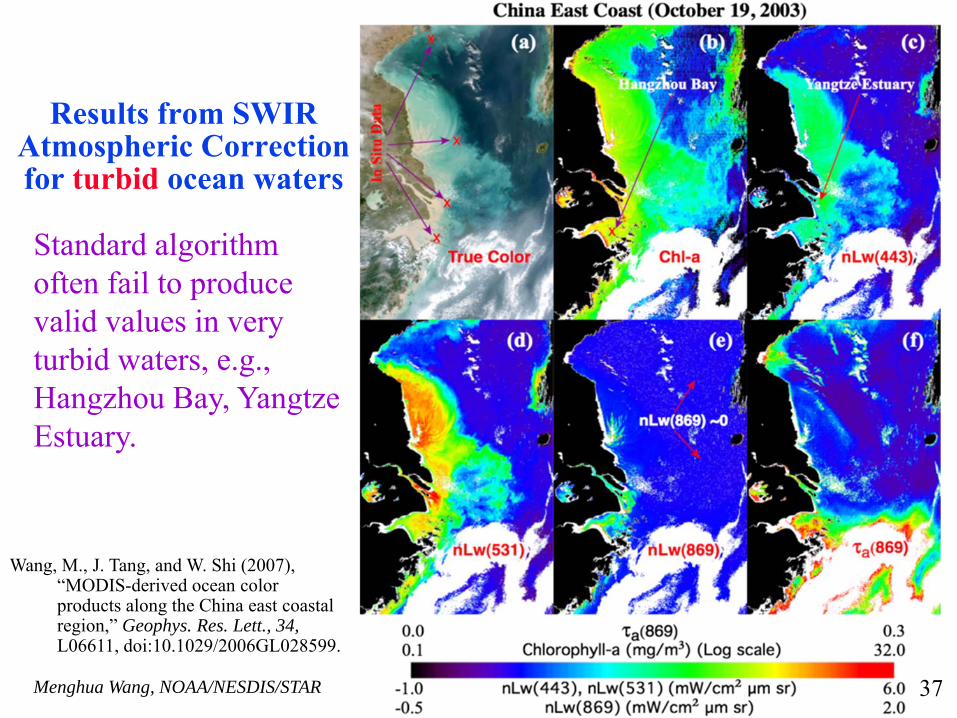
Results from SWIR Atmospheric Correction for turbid ocean waters
Standard algorithm often fail to produce valid values in very turbid waters, e.g., Hangzhou Bay, Yangtze Estuary.
Wang, M., J. Tang, and W. Shi (2007), “MODIS-derived ocean color products along the China east coastal region,” Geophys. Res. Lett., 34, L06611, doi:10.1029/2006GL028599.
37
Menghua Wang, NOAA/NESDIS/STAR
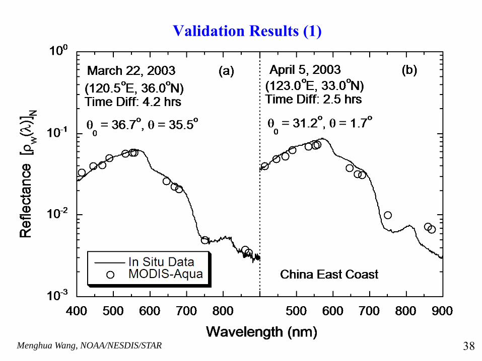
Validation Results (1)
38
Menghua Wang, NOAA/NESDIS/STAR
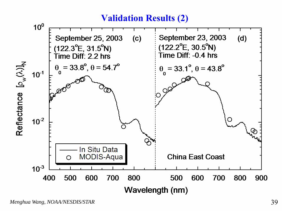
Validation Results (2)
39
Menghua Wang, NOAA/NESDIS/STAR
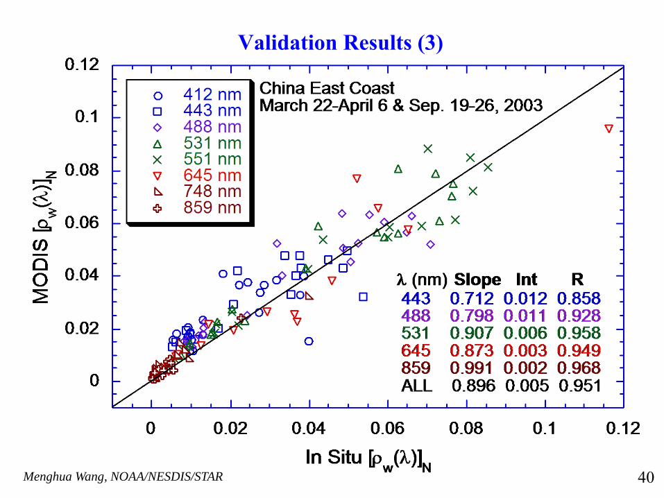
Validation Results (3)
40
Menghua Wang, NOAA/NESDIS/STAR
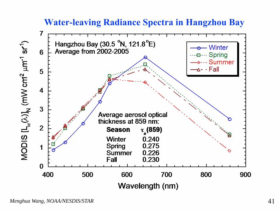
Water-leaving Radiance Spectra in Hangzhou Bay
41
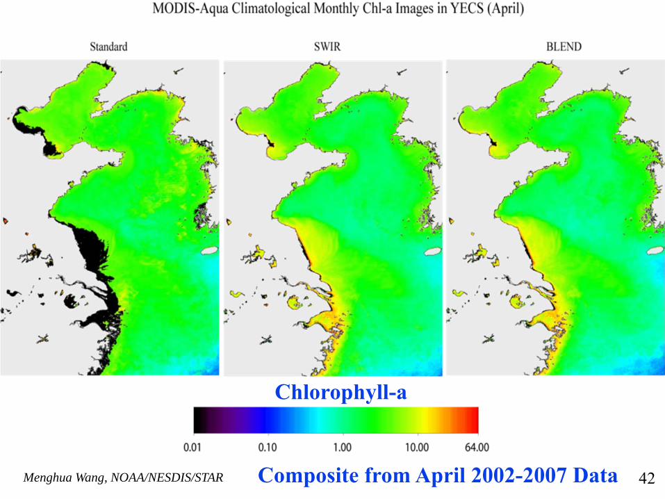
Menghua Wang, NOAA/NESDIS/STAR Composite from April 2002-2007 Data
Chlorophyll-a
42
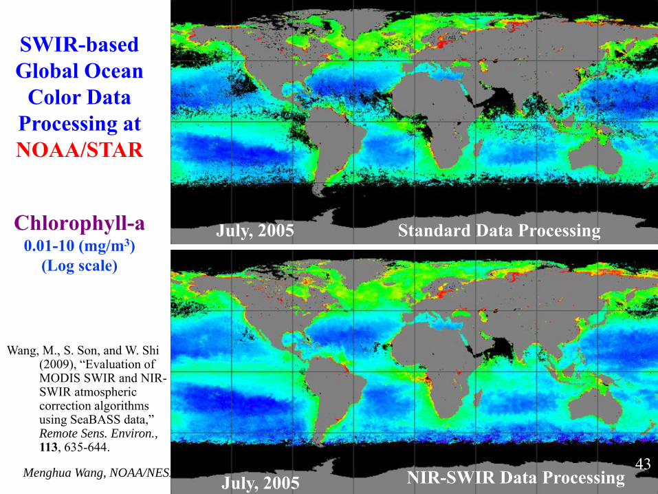
Menghua Wang, NOAA/NESDIS/STAR
Chlorophyll-a0.01-10 (mg/m3)
(Log scale)
Standard Data ProcessingJuly, 2005
July, 2005 NIR-SWIR Data Processing
Wang, M., S. Son, and W. Shi (2009), “Evaluation of MODIS SWIR and NIR-SWIR atmospheric correction algorithms using SeaBASS data,” Remote Sens. Environ., 113, 635-644.
43
SWIR-based Global Ocean
Color Data Processing at NOAA/STAR
Menghua Wang, NOAA/NESDIS/STAR
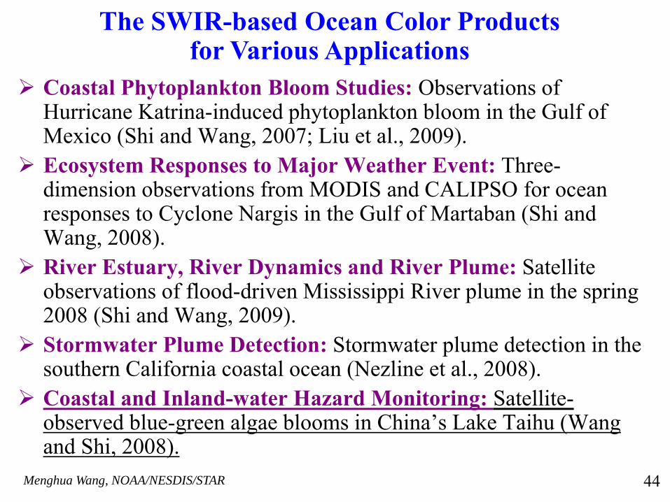
Coastal Phytoplankton Bloom Studies: Observations of Hurricane Katrina-induced phytoplankton bloom in the Gulf of Mexico (Shi and Wang, 2007; Liu et al., 2009).Ecosystem Responses to Major Weather Event: Three-dimension observations from MODIS and CALIPSO for ocean responses to Cyclone Nargis in the Gulf of Martaban (Shi and Wang, 2008).River Estuary, River Dynamics and River Plume: Satellite observations of flood-driven Mississippi River plume in the spring 2008 (Shi and Wang, 2009).Stormwater Plume Detection: Stormwater plume detection in the southern California coastal ocean (Nezline et al., 2008).Coastal and Inland-water Hazard Monitoring: Satellite-observed blue-green algae blooms in China’s Lake Taihu (Wang and Shi, 2008).
The SWIR-based Ocean Color Products for Various Applications
44
Menghua Wang, NOAA/NESDIS/STAR
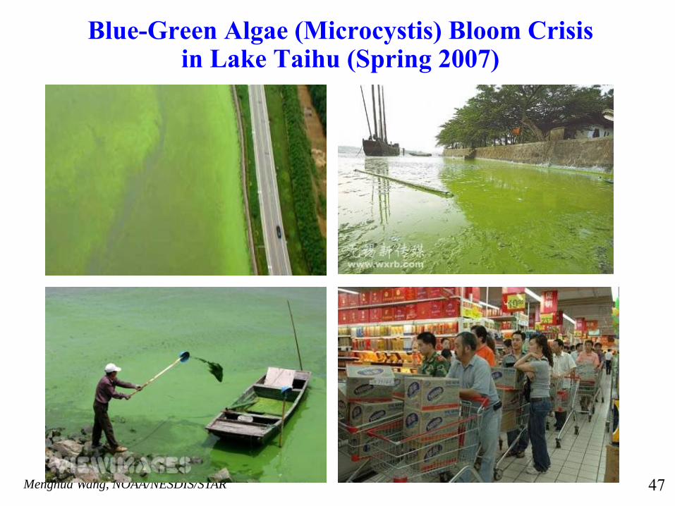
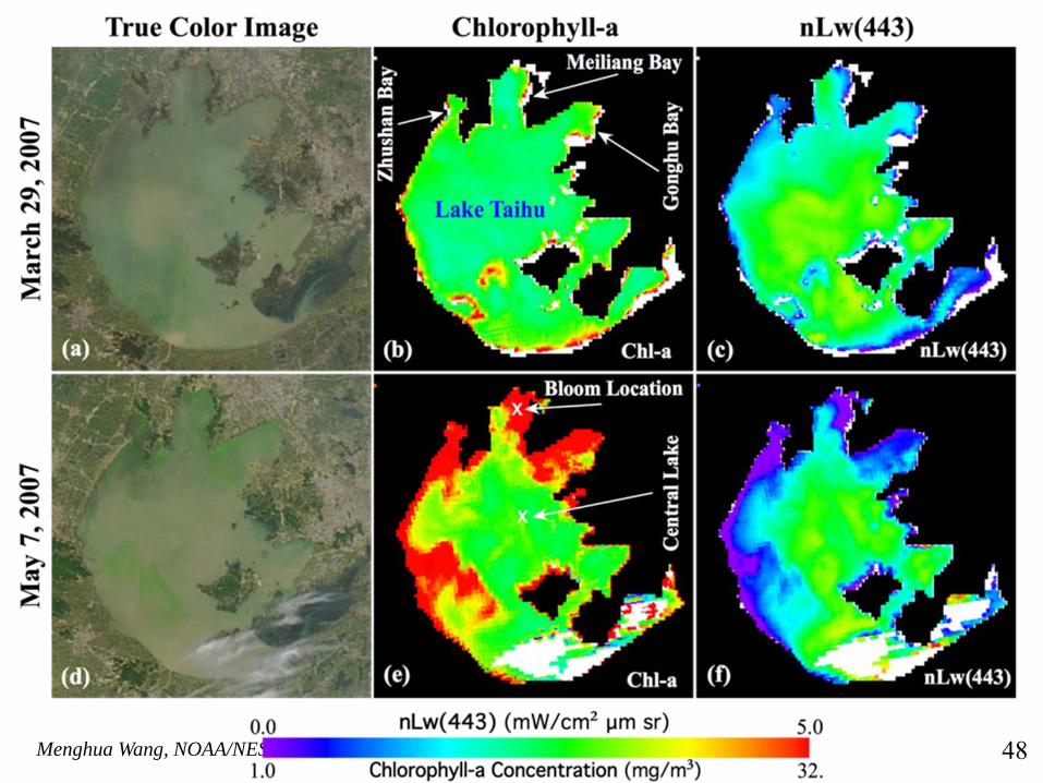
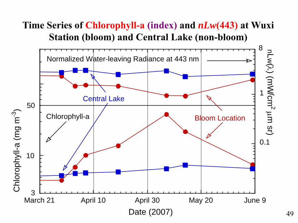
Using the SWIR algorithm, we have derived the water optical properties over the Lake Taihu using the MODIS-Aqua measurements during the spring of 2007 for monitoring a massive blue-green algae bloom, which was a major natural disaster affecting several millions residents in nearby Wuxi city.
Wang, M. and W. Shi, “Satellite observed algae blooms in China’s Lake Taihu”, Eos, Transaction, American Geophysical Union, 89, p201-202, May 27 (2008).
The work has been featured in the NASA 2008 Sensing Our Planet(http://nasadaacs.eos.nasa.gov/articles/2008/2008_algae.html)
Results from Inland Lake Taihu
45
Menghua Wang, NOAA/NESDIS/STAR
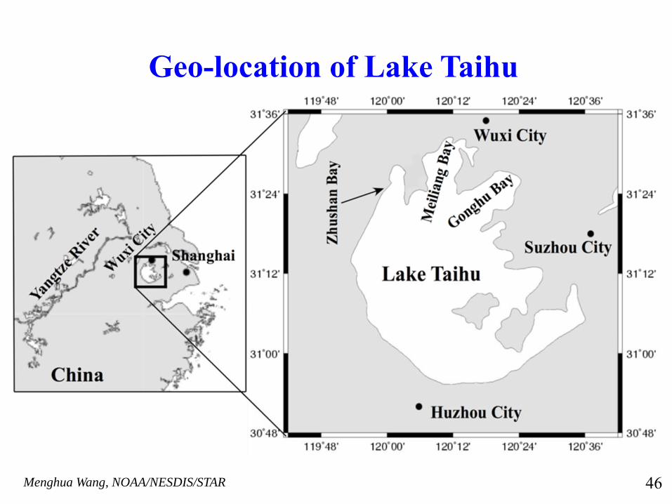
Geo-location of Lake Taihu
46
Menghua Wang, NOAA/NESDIS/STAR
Blue-Green Algae (Microcystis) Bloom Crisis in Lake Taihu (Spring 2007)
47
Menghua Wang, NOAA/NESDIS/STAR 48
Menghua Wang, NOAA/NESDIS/STAR
0.1
1
March 21 April 10 April 30 May 20 June 9
Chl
orop
hyll-
a (m
g m
-3)
nLw(λ) (mW
/cm2 μm
sr)
50
8
3
10
Normalized Water-leaving Radiance at 443 nm
Chlorophyll-a
Date (2007)
Bloom Location
Central Lake
Time Series of Chlorophyll-a (index) and nLw(443) at Wuxi Station (bloom) and Central Lake (non-bloom)
49
Menghua Wang, NOAA/NESDIS/STAR
Working with the NOAA data operational partners (OSDPD), we have been working on transferring the SWIR-based ocean color data processing system into the NOAA operational data processing system.
Near real time ocean color products will be produced using the SWIR-based algorithms for the U.S. coastal regions in NOAA CoastWatch Program.
Transition of Research to Operational for the SWIR-Based Algorithms
50
Menghua Wang, NOAA/NESDIS/STAR
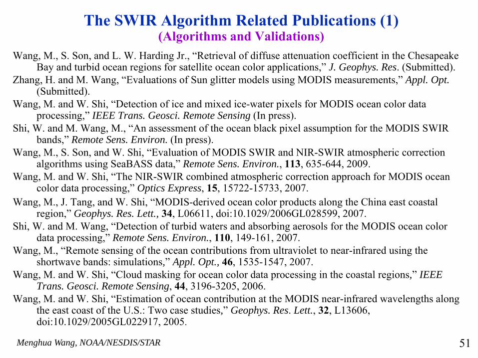
The SWIR Algorithm Related Publications (1)(Algorithms and Validations)
Wang, M., S. Son, and L. W. Harding Jr., “Retrieval of diffuse attenuation coefficient in the Chesapeake Bay and turbid ocean regions for satellite ocean color applications,” J. Geophys. Res. (Submitted).
Zhang, H. and M. Wang, “Evaluations of Sun glitter models using MODIS measurements,” Appl. Opt.(Submitted).
Wang, M. and W. Shi, “Detection of ice and mixed ice-water pixels for MODIS ocean color data processing,” IEEE Trans. Geosci. Remote Sensing (In press).
Shi, W. and M. Wang, M., “An assessment of the ocean black pixel assumption for the MODIS SWIR bands,” Remote Sens. Environ. (In press).
Wang, M., S. Son, and W. Shi, “Evaluation of MODIS SWIR and NIR-SWIR atmospheric correction algorithms using SeaBASS data,” Remote Sens. Environ., 113, 635-644, 2009.
Wang, M. and W. Shi, “The NIR-SWIR combined atmospheric correction approach for MODIS ocean color data processing,” Optics Express, 15, 15722-15733, 2007.
Wang, M., J. Tang, and W. Shi, “MODIS-derived ocean color products along the China east coastal region,” Geophys. Res. Lett., 34, L06611, doi:10.1029/2006GL028599, 2007.
Shi, W. and M. Wang, “Detection of turbid waters and absorbing aerosols for the MODIS ocean color data processing,” Remote Sens. Environ., 110, 149-161, 2007.
Wang, M., “Remote sensing of the ocean contributions from ultraviolet to near-infrared using the shortwave bands: simulations,” Appl. Opt., 46, 1535-1547, 2007.
Wang, M. and W. Shi, “Cloud masking for ocean color data processing in the coastal regions,” IEEE Trans. Geosci. Remote Sensing, 44, 3196-3205, 2006.
Wang, M. and W. Shi, “Estimation of ocean contribution at the MODIS near-infrared wavelengths along the east coast of the U.S.: Two case studies,” Geophys. Res. Lett., 32, L13606, doi:10.1029/2005GL022917, 2005.
51
Menghua Wang, NOAA/NESDIS/STAR
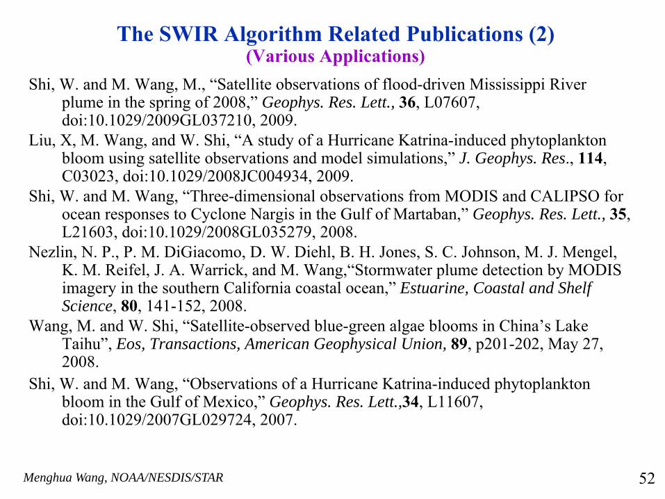
The SWIR Algorithm Related Publications (2)(Various Applications)
Shi, W. and M. Wang, M., “Satellite observations of flood-driven Mississippi River plume in the spring of 2008,” Geophys. Res. Lett., 36, L07607, doi:10.1029/2009GL037210, 2009.
Liu, X, M. Wang, and W. Shi, “A study of a Hurricane Katrina-induced phytoplankton bloom using satellite observations and model simulations,” J. Geophys. Res., 114, C03023, doi:10.1029/2008JC004934, 2009.
Shi, W. and M. Wang, “Three-dimensional observations from MODIS and CALIPSO for ocean responses to Cyclone Nargis in the Gulf of Martaban,” Geophys. Res. Lett., 35, L21603, doi:10.1029/2008GL035279, 2008.
Nezlin, N. P., P. M. DiGiacomo, D. W. Diehl, B. H. Jones, S. C. Johnson, M. J. Mengel, K. M. Reifel, J. A. Warrick, and M. Wang,“Stormwater plume detection by MODIS imagery in the southern California coastal ocean,” Estuarine, Coastal and Shelf Science, 80, 141-152, 2008.
Wang, M. and W. Shi, “Satellite-observed blue-green algae blooms in China’s Lake Taihu”, Eos, Transactions, American Geophysical Union, 89, p201-202, May 27, 2008.
Shi, W. and M. Wang, “Observations of a Hurricane Katrina-induced phytoplankton bloom in the Gulf of Mexico,” Geophys. Res. Lett.,34, L11607, doi:10.1029/2007GL029724, 2007.
52
Menghua Wang, NOAA/NESDIS/STAR
Conclusions
Both SeaWiFS and MODIS have been providing high quality ocean color products in the global open oceans. At the coastal regions, however, not only the ocean is usually Case-2 waters, but also the aerosols are often absorbing.For the turbid waters in coastal regions, shortwave infrared (SWIR) bands can be used for atmospheric correction because of significantly strong ocean absorption at the SWIR bands.Future ocean color sensors need to include the SWIR bands with sufficient SNR values for coastal and inland turbid waters.It is crucial we have on-orbit vicarious calibration.
53

Menghua Wang, NOAA/NESDIS/STAR
Thank You!
54