sanderson, d.c.w., and allyson, j.d. (1991) an aerial ...eprints.gla.ac.uk/58144/1/58144.pdf · and...
TRANSCRIPT

Sanderson, D.C.W., and Allyson, J.D. (1991) An Aerial Gamma Ray Search for a Missing 137Cs Source in the Niger Delta, May 1991. Project Report. Scottish Universities Research and Reactor Centre, East Kilbride.
Copyright © 1991 The Authors.
A copy can be downloaded for personal non-commercial research or study, without prior permission or charge The content must not be changed in any way or reproduced in any format or medium without the formal permission of the copyright holder(s) When referring to this work, full bibliographic details must be given http://eprints.gla.ac.uk/58144/ Deposited on: 20 April 2015.
Enlighten – Research publications by members of the University of Glasgow http://eprints.gla.ac.uk

AN AERIAL GAMMA RAY SEARCH FOR A MISSING
137CS SOURCE
IN THE NIGER DELTA, MAY 1991
D.C.W. SANDERSON AND J.D. ALLYSON

AN AERIAL GAMMA RAY SEARCH FOR A MISSING
137CS SOURCE
IN THE NIGER DELTA, MAY 1991
D.C.W. Sanderson J.D. Allyson
Scottish Universities Research
and Reactor Centre, East Kilbride G75 OQU
Commissioned by Atlas Wireline Services, Aberdeen in collaboration with Shell Petroleum Development
Corporation of Nigeria

CONTENTS PAGE NO SUMMARY 1 1. INTRODUCTION 2
2. THE SOURCE 2
3. METHODS AND METHODOLOGIES 4
3.1 General 4 3.2 The Aerial Survey of the Niger Delta 6
4. FIELD OPERATIONS AND RESULTS 8
4.1 Duplicate Source Tests 9 4.2 Aerial Survey of Warri and Transport Route 10 4.3 Rescue operation, Monday 20/5/91 12
5. CONCLUSIONS 13 REFERENCES 14
APPENDIX 15
TABLES Table 1 - Estimated Dose Rates from the source 3 Table 2 - Environmental Aerial Surveys Conducted by SURRC 5 Table 3 - Chronological Account of Fieldwork 8 Table 4 - Line Transect taken over Farcados Village, showing stripped
208Tl and including
the peak signals 11 Table 5 -
137Cs Stripped Count-rate 12
PLATES
Plate 1 - Installation of aerial survey equipment 16 Plate 2 - Aerial survey helicopter; Bristow Bell 212 17
Plate 3 - Warri, Nigeria 18
FIGURES Figure 1 - Shielded Source at 20m 19 Figure 2 - Shielded Source at 45m 20 Figure 3 - Shielded Source at 81m 21 Figure 4 - AWS Yard Unshielded Source 22 Figure 5 - AWS Yard Shielded Source 23 Figure 6 - Forcados Village 24 Figure 7 - Dukungha Village 25 Figure 8 - Dukungha Village 26 Figure 9 - Stripped 137-Cs Distribution 27 Figure 10 - Warri/Nigeria May 1991 28 Figure 11 - Warri & Transport Route May 1991 29

ACKNOWLEDGEMENTS
We would like to thank the following people for the help extended to the research team. Jim Clark (AWS) for hospitably accommodating us and logistic support; Bristows helicopters for adapting positively to our unexpected arrival and unusual requirements; C Ebiri (Shell Security) for providing temporary office accommodation; Shell Petroleum Engineering Division West for other operational support and finally Roger Pelly (AWS) for initiating the project.

1
SUMMARY The technique of aerial gamma-ray spectrometry has been applied to the search for a missing 74 GBq
137Cs source in the Niger
Delta, Nigeria. Comparisons with a duplicate source confirm that an unshielded source of this type is readily detected at the normal survey height of 100m. It is also possible to detect the shielded source at closer range providing the survey altitude does not exceed about 50m. The detection of an unshielded source is very likely at the normal survey altitude of 100m. A survey of the populated zones of Warri and river routes to Otumara was conducted between 9
th and 19
th May 1991. The results
demonstrate that the missing source was not present in this area in an unshielded form at this time. Signals likely to have been due to a shielded radiocaesium source were recorded. To date no
source has been recovered, but investigations are continuing. High radiation readings were recorded over part of Forcados Village, on the banks of the Warri River. They are associated with a high Thorium/Uranium concentrated source. Ground level investigations are recommended to identify the origin of these signals and evaluate their potential radiological implications. If the missing source is not located by further ground based operations, it is suggested that consideration be given to remobilising a wider and more comprehensive aerial search.

2
1. INTRODUCTION This report describes an aerial survey conducted by SURRC on behalf of Atlas Wireline Services (AWS) and the Shell Petroleum Development Corporation of Nigeria with the aim of locating a missing
137Cs source in the Niger Delta.
The source was part of an oil well logging density tool belonging to Atlas Wireline Services. It was stolen whilst within a transportation shield, along with other items, during or following transit between the Searex VI oil rig at Otumara and the Shell jetty at Warri between 4th and 7th April 1991. In view of the possible consequences of exposure or damage to the source AWS Safety Officer contacted SURRC on the 11th April to discuss the possibility of its detection by remote sensing.
On the basis that an unshielded source is both readily detectable and represents a considerable hazard a decision was taken to mobilise an aerial search of the local area. An "emergency response" gamma spectrometry system was tested and shipped from East Kilbride on 16th April for this purpose. Although the shielded source is much less hazardous initial assessments were that under favourable circumstances even this might be detected. Once necessary innoculations and visas had been obtained - unfortunately a lengthy process - the SURRC search team travelled to Warri, arriving on 9th May, to start field operations. Initial aims were: a) to establish survey capability using available aircraft, in unmodified form, to demonstrate the detectability of a
duplicate source both inside and outside its transport shield.
b) to conduct a search of the Otumara-Warri transport route and the main populated areas in and around Warri in sufficient detail to identify any unshielded source which might be present. These tasks were all accomplished during the following 16 days. Results were obtained which suggest that the source was probably located in its transport shield at Dukungha village, south of the Warri port during the course of the survey. 2. THE SOURCE The missing source consisted of 74 GBq (2 Ci) Cs. This
radioisotope of caesium decays with a 30.2 year half life and is accompanied by the energetic emission of 662 keV gamma-rays. At the time of theft it was in a shielded transport container comprising of 35 kg lead, the lid secured by hasps and padlocks, and chained to a metal cage containing other items for shipment by barge from Otumara to Warri. Table 1 summarises the expected dose rates from both unshielded and shielded sources of this type, the latter being derived from measured dose rate values of the complete assembly.

3
Radiologically, the shielded assembly presents a modest hazard capable of exposing individuals within 2-3m of the source for long periods above the ICRP recommended annual limit for public exposure. Outside this range there would be little danger providing the source remains intact. If the shielding were damaged or removed, the source would represent a considerable hazard both to people in the immediate proximity - for whom there is a risk of acute effects developing as a result of protracted exposure - and to those in surrounding areas (of many tens of metres in distance) for which increased stochastic risks may be presented. If the source itself were damaged there is a potential contamination hazard with long term environmental implications. The physical form of the source however may go some way to mitigating these latter effects.
Of these hazards it is evident that the radiation hazard associated with an unshielded source presents the greatest risk, and that the possibility of exposure of the source within a densely populated area is of most immediate concern. Table 1. Estimated Dose Rates from the Source. Condition Distance /m Dose Rate __________________________________________________________________
Shielded 1 25 μGy/hr 220 mGy/a
by Transport Container 10 250 nGy/hr 2.2 mSv/a
100 2.5 nSv/hr 22 μSv/a Unshielded 1 8.7 mGy/hr
10 87 μGy/hr
100 870 nGy/hr
Damaged Partial radiation and contamination hazard __________________________________________________________________
4
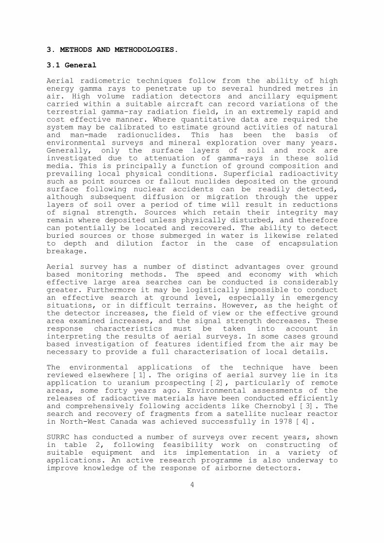
3. METHODS AND METHODOLOGIES. 3.1 General Aerial radiometric techniques follow from the ability of high energy gamma rays to penetrate up to several hundred metres in air. High volume radiation detectors and ancillary equipment carried within a suitable aircraft can record variations of the terrestrial gamma-ray radiation field, in an extremely rapid and cost effective manner. Where quantitative data are required the system may be calibrated to estimate ground activities of natural and man-made radionuclides. This has been the basis of environmental surveys and mineral exploration over many years. Generally, only the surface layers of soil and rock are investigated due to attenuation of gamma-rays in these solid media. This is principally a function of ground composition and
prevailing local physical conditions. Superficial radioactivity such as point sources or fallout nuclides deposited on the ground surface following nuclear accidents can be readily detected, although subsequent diffusion or migration through the upper layers of soil over a period of time will result in reductions of signal strength. Sources which retain their integrity may remain where deposited unless physically disturbed, and therefore can potentially be located and recovered. The ability to detect buried sources or those submerged in water is likewise related to depth and dilution factor in the case of encapsulation breakage. Aerial survey has a number of distinct advantages over ground based monitoring methods. The speed and economy with which effective large area searches can be conducted is considerably greater. Furthermore it may be logistically impossible to conduct
an effective search at ground level, especially in emergency situations, or in difficult terrains. However, as the height of the detector increases, the field of view or the effective ground area examined increases, and the signal strength decreases. These response characteristics must be taken into account in interpreting the results of aerial surveys. In some cases ground based investigation of features identified from the air may be necessary to provide a full characterisation of local details. The environmental applications of the technique have been reviewed elsewhere [1]. The origins of aerial survey lie in its application to uranium prospecting [2], particularly of remote areas, some forty years ago. Environmental assessments of the releases of radioactive materials have been conducted efficiently and comprehensively following accidents like Chernobyl [3]. The
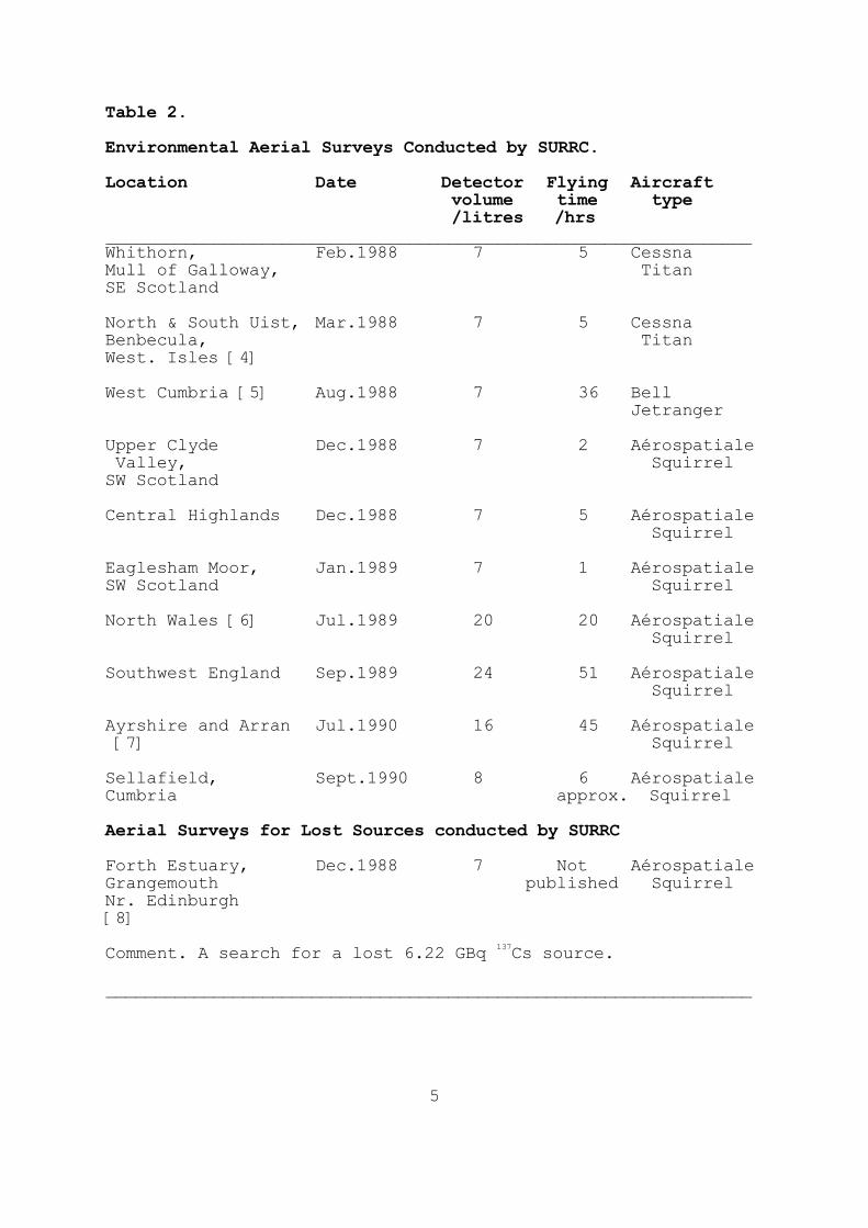
search and recovery of fragments from a satellite nuclear reactor in North-West Canada was achieved successfully in 1978 [4]. SURRC has conducted a number of surveys over recent years, shown in table 2, following feasibility work on constructing of suitable equipment and its implementation in a variety of applications. An active research programme is also underway to improve knowledge of the response of airborne detectors.
5
Table 2. Environmental Aerial Surveys Conducted by SURRC. Location Date Detector Flying Aircraft
volume time type /litres /hrs
__________________________________________________________________ Whithorn, Feb.1988 7 5 Cessna Mull of Galloway, Titan SE Scotland North & South Uist, Mar.1988 7 5 Cessna Benbecula, Titan West. Isles [4]
West Cumbria [5] Aug.1988 7 36 Bell Jetranger Upper Clyde Dec.1988 7 2 Aérospatiale Valley, Squirrel SW Scotland Central Highlands Dec.1988 7 5 Aérospatiale Squirrel Eaglesham Moor, Jan.1989 7 1 Aérospatiale SW Scotland Squirrel North Wales [6] Jul.1989 20 20 Aérospatiale Squirrel
Southwest England Sep.1989 24 51 Aérospatiale Squirrel Ayrshire and Arran Jul.1990 16 45 Aérospatiale [7] Squirrel Sellafield, Sept.1990 8 6 Aérospatiale Cumbria approx. Squirrel Aerial Surveys for Lost Sources conducted by SURRC Forth Estuary, Dec.1988 7 Not Aérospatiale Grangemouth published Squirrel Nr. Edinburgh [8]
Comment. A search for a lost 6.22 GBq
137Cs source.
__________________________________________________________________

6
3.2 The Aerial Survey of the Niger Delta Prior to departure from the UK information regarding various operational details was ascertained as far as communications allowed. Although aircraft type could not be confirmed before departure the spectrometry equipment was selected for flexibility of installation, the intention being to adapt the precise recording methods and installation to suit local conditions. Avionic capability for routine surveys includes radioaltimetry, with analogue output to provide a continuous record of survey height, and navigational instrumentation to provide on-line positional information in latitude and longitude. Cabin cooling is regarded as a pre-requisite for surveys in tropical regions with delicate and sensitive equipment.
It became apparent upon our arrival that, despite contrary expectations, the aircraft available were not fully equipped to routine survey standards. After further enquiries by Atlas Wireline Services into the availability of suitably instrumented aircraft for dedicated use it was decided to persevere with the Bristows Bell 212 helicopters used for personnel transport by Shell, for the first phase of the aerial search. This introduced a number of operational constraints; namely lack of navigational equipment, high cabin temperatures (up to 37°C on one occasion), and limited and sporadic availability due to a high workload for the primary task. Adaptions to both equipment and survey methodology were needed to accommodate such constraints. The navigational problem was dealt with in a straightforward though time consuming manner. Shell Security and Petroleum Engineering Divisions respectively
obtained detailed maps of Warri and the surrounding delta areas. Flight paths were constrained as far as possible to straight line sections flown at constant height and speed. End points and times were marked on the appropriate maps during each flight and positions for each spectral observation calculated by interpolation during post flight data analysis. This technique worked satisfactorily within limits but introduced a considerable analytical burden, with consequent delays, to data processing. Radioaltimetry data were available intermittently on one of the Bristows Bell 212 (QV) helicopters, and this aircraft was used, subject to its other commitments. The high cabin temperatures caused initial instrumental problems. Although the spectrometer worked fully in the air conditioned AWS workshop from the beginning, it was unable to sustain extended
operation at ambient temperatures. A sequence of tests and modifications was immediately implemented to extend the operational period at high temperatures. Elimination of duplicated or unnecessary components rapidly extended the cycle time to one hour. Sustained operation was eventually achieved by increasing the ventilation of the logging computer and fitting two auxiliary cooling fans. The assistance of Grant Ireland in the Bristows Avionics section is gratefully acknowledged.

7
Despite these technical difficulties, and the rapid
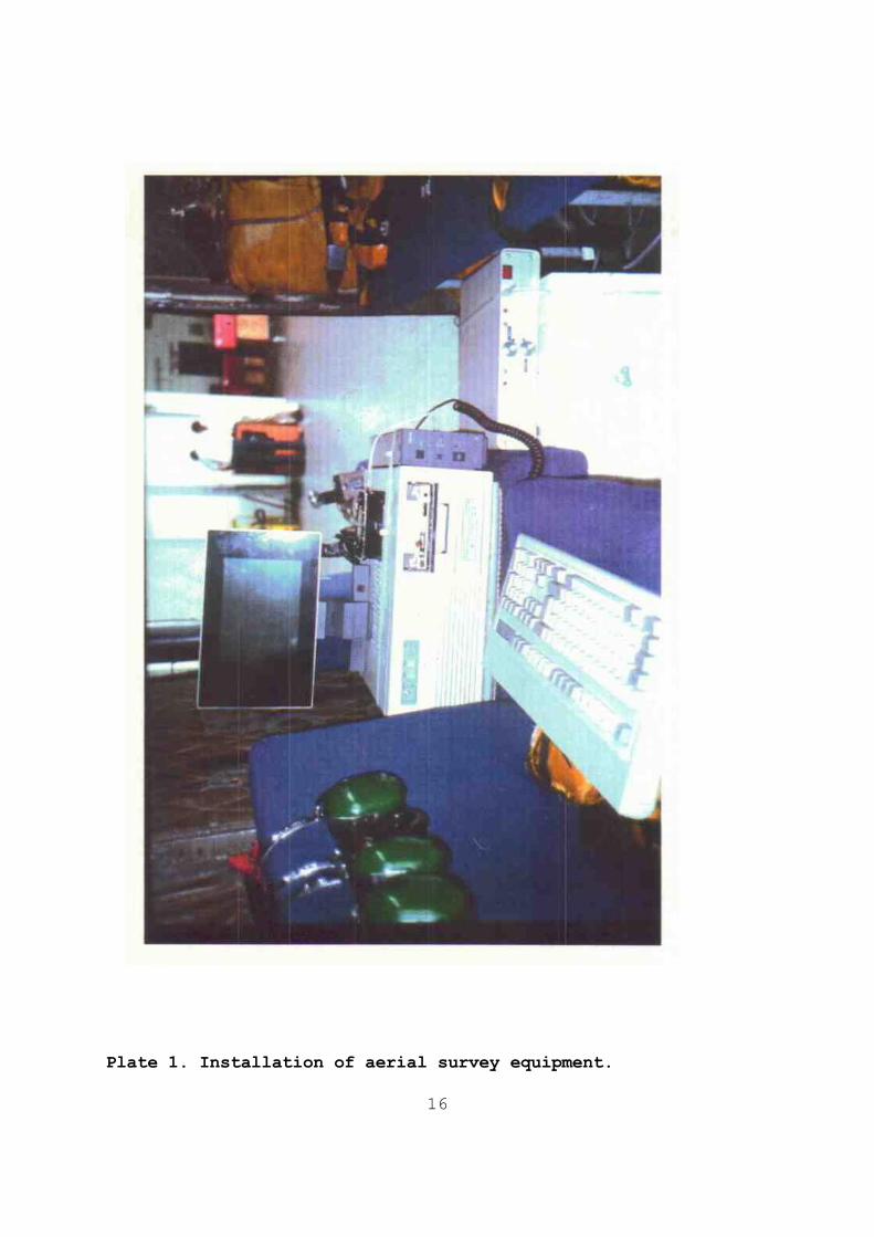
acclimatisation of the SURRC team, the system was made operational and used to investigate the built up parts of Warri, outlying villages and the transportation route to Otumara. Warri was surveyed in roughly parallel lines avoiding hazardous or sensitive areas (Army Barracks, aerial masts, tall industrial plant, etc) at the discretion of the pilot. The outer lying villages were treated in a similar manner, depending upon size. The transportation waterways were searched by flying the contours of both sides of the river banks. Roughly 2600 gamma ray spectra were recorded, mapped and analysed from these areas. Plate 1 shows the equipment mounted within the Bristow Bell 212 helicopter, (Plate 2). Plate 3 is a view of Warri at survey altitude, nominally 75m.

8
4. FIELD OPERATIONS AND RESULTS A brief chronological account of the fieldwork is shown in Table 3.
Table 3. Chronological Account of Fieldwork.
Date Diary ___________________________________________________________________ 9/5/91 Thursday Arrival of SURRC team in Warri.
Equipment un-packed and tested in air-conditioned lab., at AWS yard.
10/5/91 Friday Meeting at Shell Security. 6 hours of flight time allocated. Swim test. First test flight. Overheating problems of equipment become apparent. Work to
solve problems begins in Avionics Bay, Bristow Helicopters.
11/5/91 Saturday Work all day on equipment. Ground tests using a duplicate shielded
137Cs
source.
12/5/91 Sunday Second flight. Faulty H.V. lead delays spectrometer installation. Flight commences with hand-held monitors, over S. Warri. Survey equipment installed for third flight. Continuous operation for first hour, until overheating occurs once more. Cooling fans installed.
13/5/91 Monday Equipment tested and found to be
functioning correctly. Spectral data and flight path recovery processing.
14/5/91 Tuesday Meeting to review progress and plan further action. Afternoon flight to
Otumara via Warri River & creeks.
Burutu surveyed. Anomally observed over Forcados. Unshielded source at AWS yard overflown. S. Warri town, Orugbo, Ode-
Itsekiri & Ogunu villages surveyed.
Later village to west of Gulf jetty, 2 villages at Amadano Creek, N. Warri and area west of Ogunu flown.
15/5/91 Wednesday Equipment checked & OK.
16/5/91 Thursday Data analysis. No further flights
booked.
17/5/91 Friday Equipment checked & OK. Further 6
hours of flying agreed.

9
Table 3 (Cont)
--------------------------------------------------------------
18/5/91 Saturday Warri, Jones Creek & Rivers surveyed. Forcados revisited. Forcados exhibits localised and potentially hazardous radiation source.
19/5/91 Sunday Warri completed. Shielded source over AWS yard repeated. Agbarho flown. Transportation routes completed. Outlying villages around Warri flown. Dukungha Village revisited. Data interpretation and discussion of Dukungha measurements carried to late evening.
20/5/91 Monday Meeting at Shell with PEDW. Sufficient evidence to warrant a coordinated operation to attempt to recover the source. Signal over Dukungha no longer detectable. Operation called off.
21/5/91-22/5/91 Further data analysis and flight track reconstruction. Preparation of condensed summary of findings.
23/5/91 Thursday Meeting with TEMW. All results discussed. Ground investigations to be intensified. Further aerial surveys suspended until these investigations have been carried out.
24/5/91 Friday SURRC team return to UK. ___________________________________________________________________ 4.1 Duplicate Source Tests In order to have a clear impression of the likely strength of signals to be expected from a shielded and unshielded
137Cs
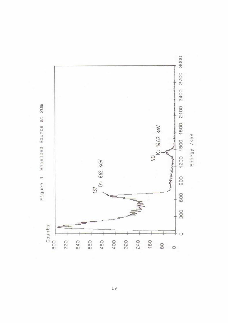
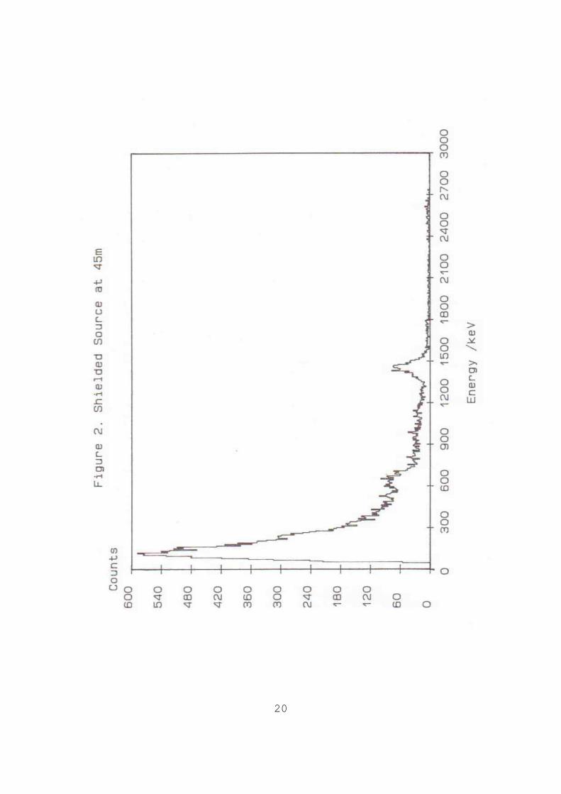
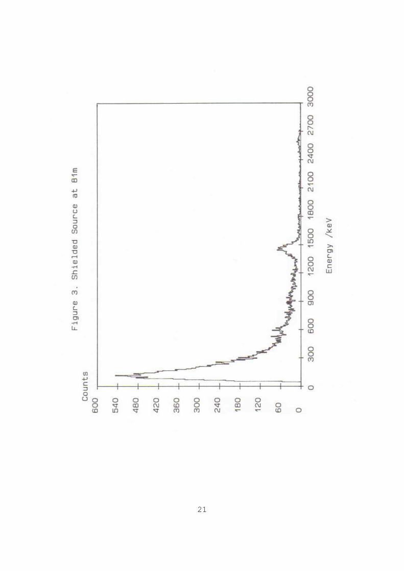
source, of similar activity to the one lost, a number of experiments were performed with a duplicate: a) Ground tests were made with the shielded source placed at known distances from the detector array: the source remained detectable to a distance of approximately 50m, despite enhanced ground contributions from terrestrial gamma-rays. The spectra
from some of these tests are shown in figures 1, 2 and 3, for source-detector distances of 20m, 45m and 81m respectively. b) Airborne tests made with the shielded and unshielded source over the AWS yard. Figure 4 shows the unshielded source at normal survey altitude (approx. 100m) and about 70 knots flying speed. Figure 5 shows the corresponding shielded source at 50m altitude, recorded on 19/5/91 at slow speed.

10
Overall the detectability of the source was well confirmed by
these tests. Line spacing of 200-300m and flight speed of 70-80 knots provide total coverage for detection of an unshielded source. Detector sensitivity is sufficient to give immediate and unambiguous indication of such a signal. A shielded source is also detectable although closer flight lines, lower survey speed and preferably lower altitude are needed to conduct high density search for such an item. Additionally the signals associated with shielded sources must be extracted by spectral stripping to subtract the background signals due natural radiation sources. 4.2 Aerial Survey of Warri and the Transportation Routes Priority was given to the aerial survey of Warri, to eliminate the possibility of an unshielded source in such a densely populated area. The most important finding was that no such
signal was detected (except during the brief and deliberate exposure of the duplicate source at AWS to confirm detectability). There was some doubt as to the exact transportation route taken between Searex VI and the Shell jetty. Therefore the most likely routes were eliminated in a systematic way, bearing in mind flying time available (helicopter duration was approx. 2-2.5 hours), distances involved and pockets of habitation whose past reputation had been raised by Shell security. A strong signal was observed over Forcados village (map reference: 5'21.59 lat. 5'26.7 long.). Subsequent analysis showed this to be due to a Uranium/Thorium source of unusually high concentration. The spectral data, shown in figure 6, records decay products of these parent radionuclides by measuring
214Bi (a
daughter of 238U) and
208Tl (a daughter of
232Th) at 1764 keV and
2615 keV respectively. Apparently this source may be due to a "spectrolog calibrator" and certainly requires further ground investigations and removal. For comparison a second spectrum is plotted in figure 6, recorded approximately 30 seconds after the peak Forcados signal, indicating the change in signal experienced. Table 5 shows the flight transect over the peak signal in terms of stripped
208Tl count-rate (true count-rate and
interference free). The total gamma radiation count rate was elevated by up to 50 times the ambient level over the centre point of this object. At even closer proximity higher levels still are expected. The Delta steel works in Warri produced a signal which is thought to mainly originate from the natural series (probably slag
enhancing refractory nuclides). However on spectral deconvolution, a residual radiocaesium signal was also (equivalent to a shielded source in strength) observed. The possibility that radioactivity has been inadvertently incorporated into scrap metal should not be overlooked; indeed there are precedents for this in other parts of the world.

11
Table 4. Line transect taken over Forcados village, showing stripped
208Tl and including the peak signal.
Date Time Filename Latitude Longitude
208Tl
/cps _________________________________________________________________ 18/5/91 15:31:28 WAR18006B 5'21.68 5'26.3 11. 5 15:31:42 WAR18007A 5'21.8 5'26.35 50.7 15:31:56 WAR18007B 5'21.8 5'26.45 73.5 15:32:12 WAR18008A 5'21.8 5'26.55 46.9 15:32:25 WAR18008B 5'21.8 5'26.26 44.8 15:32:39 WAR18009A 5'21.76 5'26.7 67.4 15:32:53 WAR18009B 5'21.68 5'26.7 118.2 15:33:07 WAR18010A 5'21.59 5'26.7 163.8 15:33:22 WAR18010B 5'21.51 5'26.7 91.5
15:33:36 WAR18011A 5'21.43 5'26.7 32.4 15:33:49 WAR18011B 5'21.34 5'26.7 11.8 ___________________________________________________________________ Low intensity anomalies were recorded close to the Schlumberger yard, within Warri market and Dunkungha village. These were attributed to radiocaesium on spectral grounds. In the first, the navigational reconstruction actually placed the anomaly directly across the river from the logging company's premises. This may have highlighted the limitations of mapping position by fiducial markers and interpolation. The chance interception of sources belonging to other logging operators and being in transit was considered and steps were taken by Shell to identify the locations of such legitimate sources.
Of the second anomalous signal, initial spectral stripping revealed a weaker signal strength than that corresponding to a shielded source, but slightly above the average measurements recorded up to that point. A working estimate of minimum detectable level suggested that these signals carried marginal statistical significance. A brief ground level investigation of the market by the AWS Safety Engineer and a plain clothes policeman confirmed this interpretation. The third signal over Dukungha village represented a signal of strength between the above second outlier and a shielded source. This was reported to the meeting on Thursday 16/5/91. Because of its relative isolation, an investigation by boat was necessary. During the Saturday (18/5/91) and Sunday (19/5/91) further
flights were made to complete Warri, the peripheral villages and waterway routes. On late Sunday evening, Dukungha village was revisited for the third time and anomalous caesium signals re-affirmed. Figure 7 shows the anomalous signal (c.f. figure 5) and figure 8, the spectrum taken during an interval 10 seconds later. On the basis of this, a meeting was called early Monday morning, 20/5/91, and subsequent events are recorded in section 4.3.

12
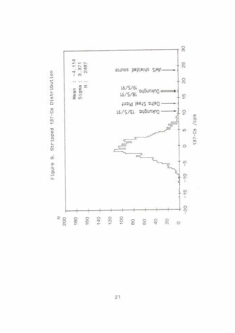
The distribution of stripped count-rate 137Cs encountered
throughout the whole survey period is shown in figure 9. The Dukungha village feature is the only unexplained anomaly, well to the right of the general distribution. The maps in the final figures show the stripped
137Cs count-rate
variation over the entire survey area and Warri. The results from the duplicate source tests have been omitted. Table 5 shows the values of
137Cs stripped count-rate recorded
over the indicated sites. Table 5.
137Cs stripped Count-rate.
Site Date
137Cs Filename
/ cps _________________________________________________________ AWS Shielded Source 12/5/91 23.7 WAR01027 AWS Unshielded Source 13/5/91 1871 WAR10012 Dukungha Village 14/5/91 10.9 WAR11059 Dukungha Village 18/5/91 17.1 WAR19012 Dukungha Village 19/5/91 17.6 WAR23105 Delta Steel Plant 19/5/91 13.6 WAR21079 _________________________________________________________
4.3 Rescue Operation, Monday 20/5/91 Careful spectral analysis of the weekend flying operation was sufficiently convincing, both in terms of signal strength that might be expected from a shielded source (either in a transport
container or buried beneath ground/water) and characteristic gamma-ray energy, that a meeting was called on Monday, 20/5/91. The proximity of Dukungha Village to the Shell jetty (one of the likely places for the theft to have occurred) and its relative isolation, gave extra circumstantial credence to the findings. A full briefing between those concerned and the AWS Safety Engineer (who would be supervising the ground operation), was made to ensure radiological safety and to define appropriate countermeasures in the event of finding a breached source container. A co-ordinated air-ground operation, facilitated by walky-talky communication, commenced in the late afternoon and was led by the survey helicopter. Three seatrucks of 12 policemen (5 armed)
stood close-by in the Warri River. Diving crews had been alerted to the possibility of a water recovery operation. However, the survey equipment could not positively identify the signal, despite flying at half the survey height (approx. 30m) and much slower (less than 50 knots). The complete area was repeatedly swept four times.

13
Without positive location from the helicopter it was not possible
to guide ground teams directly to the house or houses from which the Cs signal had been detected beforehand. since the signals had been clearly present on all three previous overflights of Dukungha, it can be inferred that the Cs source had either been moved or covered between Sunday 19/5/91 and Monday 1700 hours 20/5/91. Subsequent re-examination of the spectral evidence back at SURRC in June 1991 has reinforced the positive nature of the evidence. 5. CONCLUSIONS The following conclusions may be drawn from this experience.
1) The capabilities of aerial surveys to detect missing source of this sort were confirmed, and also the adaptability of appropriate equipment to the field conditions which occur in remote oil locations. 2) It was clearly demonstrated that no unshielded source hazard was present in the survey area at the time of the survey. 3) The shielded source was, and is, detectable. A total survey for the shielded source would be possible, however but 50m line spacing and 30-50m altitude would be needed for complete coverage. 4) The Dukungha signals have all the required features of the shielded source. The location of the site, and the fact that the source had been moved only add to suspicions that this was in
fact the missing source. 5) We recommend that further investigations (at ground level) focus on Dukungha and that if this fails consideration be given to remobilising a wider survey. 6) It is suggested that contingency plans be laid for more rapid mobilisation to oil fields in case of similar future incidents. 7) The use of dedicated aircraft, more rapid ground based investigation of anomalies, and a more discrete operation may have a greater chance of success. This is particularly important under the unusual situation that sources may be being held to ransom by individuals who are aware of what they have.

14
REFERENCES [1] SANDERSON, D.C.W., SCOTT, E.M., BAXTER, M.S., Use of Airborne Radiometric Measurements for Monitoring Environmental Radioactive Contamination, IAEA SM-306/138, 411-421, Vienna, 1990 [2] INTERNATIONAL ATOMIC ENERGY AGENCY, Recommended Instrumentation for Uranium and Thorium Exploration, Technical Reports Series No. 158, IAEA Vienna, 1974. [3] LINDEN, A., MELLANDER, H., Airborne Measurements in Sweden of the Radioactivity Fallout after the Nuclear Accident in Chernobyl, USSR, Rep. TFRAP 8606, Sweden Geological Co., Uppsala, 1986. [4] GRASTY, R.L., The Search for Cosmos 954: Search Theory and
Applications, Plenum Press, New York, 1980, p211-220. [5] SANDERSON, D.C.W., SCOTT, E.M., BAXTER, M.S., PRESTON, T., A feasibility study of airborne radiometric survey for UK fallout, Rep. 88-03, Scottish Universities Research and Reactor Centre, 1988. [6] SANDERSON, D.C.W., SCOTT, E.M., Aerial Radiometric Survey in West Cumbria in 1988, Food Science Report N611, Ministry of Agriculture, Fisheries and Food, London, 1988. [7] SANDERSON, D.C.W., EAST, B.W., SCOTT, E.M., Aerial Radiometric Survey of Parts of North Wales in July 1989, Survey Report, Scottish Universities Research and Reactor Centre, 1989. [8] SANDERSON, D.C.W., ALLYSON, J.D., MARTIN, E., TYLER, A.N.,
SCOTT, E. M., An Aerial Gamma-ray Survey of Three Ayrshire Districts. Commissioned by the District Councils of Cunninghame, Kilmarnock and Loudon, and Kyle and Carrick, 1990. [9] SANDERSON, D.C.W., EAST, B.W., ROBERTSON, I., SCOTT, E.M., The Use of Aerial Radiometrics in the Search for a Lost
137Cs
Source. Confidential report. 1988.

15
APPENDIX Equipment Inventory 8 litre detector array 286 PC computer with: GPS prototype navigational system Rad-alt ADC card 2 MCB cards EGA LCD display display power supply keyboard Detector power supplies
4 AC Delco sealed batteries (2 back-ups) DC/AC power inverters+cables from helicopter supply Battery charger (24v) GPS Navsat antenna+cable (aircraft antenna unavailable) LC10 printer+paper Full set of necessary cables Long extension lead Computer anti-vibration pad
Accessories Spare summing amplifier and distribution board Spare mains inverter (RS) Spare cables Tools: portable soldering iron solder screwdrivers (flat and cross-head) snips small voltmeter Insulation tape
Spare discs+tapes Back-up discs (system discs, "AERO" & "MCA26/MCA27" programs) Bungee cords, spare fuses and connectors
16
Plate 1. Installation of aerial survey equipment.

17
Plate 2. Aerial survey helicopter: Bristow Bell 212.

18
Plate 3. Warri, Nigeria.
19
20
21

22

23

24

25

26
27

28

29