samoa town master plan
TRANSCRIPT

Samoa Town Master Plan
Draft Supplemental Master Environmental Impact Report
July 2019 Lead Agency: Humboldt County Planning & Building Department

Samoa Town Master Plan
Draft Supplemental Master
Environmental Impact Report
State Clearinghouse # 2003052054
July 2019
Lead Agency: Humboldt County
Planning & Building Department
Send comments to: Michael Wheeler, Senior Planner
Humboldt County Planning & Building Department 3015 H Street
Eureka, California 95501 [email protected]
This document printed on recycled paper

This page intentionally left blank.

County of Humboldt Samoa Town Master Plan
Draft Supplemental MEIR i Table of Contents
TABLE OF CONTENTS Summary Page
Introduction ..................................................................................................................... S-1 Project Summary ............................................................................................................. S-1 Significant & Unavoidable Impacts ................................................................................. S-2 Summary of Impacts & Mitigation Measures Analyzed in this SMEIR ........................... S-2
Chapter 1.0 Introduction 1.1 Purpose of SMEIR .......................................................................................................... 1-1 1.2 Project Background ......................................................................................................... 1-1 1.3 Scope and Contents of SMEIR ....................................................................................... 1-5 1.4 Environmental Review Process ...................................................................................... 1-7
Chapter 2.0 Project Description 2.1 Project Location .............................................................................................................. 2-1 2.2 Project Objectives ........................................................................................................... 2-1 2.3 Modifications to the Approved Project ............................................................................ 2-2 2.4 Project Characteristics & Phasing ................................................................................... 2-2 2.5 Wastewater Disposal Alternative .................................................................................... 2-8 2.6 Development Agreement ................................................................................................ 2-8 2.7 Intended Use of this Supplemental EIR .......................................................................... 2-11 2.8 Required Approvals ......................................................................................................... 2-11
Chapter 3.0 Environmental Analysis 3.1 Cultural Resources
Background & Introduction .............................................................................................. 3.1-1 Environmental & Regulatory Setting ............................................................................... 3.1-1 Impacts & Mitigation Measures ....................................................................................... 3.1-3
3.2 Biological Resources Background & Introduction .............................................................................................. 3.2-1 Environmental & Regulatory Setting ............................................................................... 3.2-1 Impacts & Mitigation Measures ....................................................................................... 3.2-12
3.3 Greenhouse Gas Emissions Background & Introduction .............................................................................................. 3.3-1 Environmental & Regulatory Setting ............................................................................... 3.3-1 Impacts & Mitigation Measures ....................................................................................... 3.3-7
3.4 Transportation Background & Introduction .............................................................................................. 3.4-1 Environmental & Regulatory Setting ............................................................................... 3.4-1 Impacts & Mitigation Measures ....................................................................................... 3.4-5
3.5 Energy Consumption and Conservation Background & Introduction .............................................................................................. 3.5-1 Environmental & Regulatory Setting ............................................................................... 3.5-1

County of Humboldt Samoa Town Master Plan
Draft Supplemental MEIR ii Table of Contents
Impacts & Mitigation Measures ....................................................................................... 3.5-11 3.6 Aesthetics Background & Introduction .............................................................................................. 3.6-1 Environmental & Regulatory Setting ............................................................................... 3.6-1 Impacts & Mitigation Measures ....................................................................................... 3.6-5 3.7 Wildfire Background & Introduction .............................................................................................. 3.7-1 Environmental & Regulatory Setting ............................................................................... 3.7-1 Impacts & Mitigation Measures ....................................................................................... 3.7-3
Chapter 4.0 Other CEQA Considerations 4.1 Alternatives ..................................................................................................................... 4-1 Off-site Treated Wastewater Disposal Alternative .......................................................... 4-1 RMT II Ocean Outfall Pipe Background/ Existing Conditions ......................................... 4-3 Potential Environmental Impacts of Off-site Treated Wastewater Disposal Alternative . 4-4 4.2 Cumulative Impacts ......................................................................................................... 4-14 4.3 Growth Inducing Impacts ................................................................................................ 4-15 4.4 Significant Irreversible Environmental Effects ................................................................ 4-15 4.5 New Unavoidable Significant Environmental Effects ...................................................... 4-15 4.6 Mitigation Measures ........................................................................................................ 4-16
Chapter 5.0 Document Preparers EIR Authors/Consultants ................................................................................................. 5-1
Appendices A SMEIR NOP and Comment Letters Received (2013 and 2018) B Town of Samoa Contributing Outbuilding Study C Biological Report Addendum D Greenhouse Gas Emission Technical Report E W-trans July 19, 2013 Memorandum – Samoa Industrial Waterfront Transportation Access Plan
Traffic Impacts F Design Review Checklists and Schematics G Certified (2009) MEIR MMRP
LIST OF FIGURES Figure 1-1 Samoa Town Master Plan Location ................................................................... 1-2 Figure 2-1 Samoa Town Master Plan Area.......................................................................... 2-4 Figure 2-2 STMP Land Use Map ......................................................................................... 2-5 Figure 2-3 Wastewater Disposal Alternative ........................................................................ 2-8 Figure 3.2-1 Rare Plant Map 2018 ..................................................................................... 3.2-6 Figure 3.2-2 Wetland Delineation 2018 ............................................................................ 3.2-10 Figure 3.2-3 EHSA Map 2018 .......................................................................................... 3.2-16

County of Humboldt Samoa Town Master Plan
Draft Supplemental MEIR iii Table of Contents
Figure 3.2-4 Proposed Samoa Dunes Interpretive Area .................................................. 3.2-18 Figure 3.2-5 Proposed Milwaukee Beach Access Parking Improvements ...................... 3.2-19 Figure 3.4-1 Traffic Volumes (2013) ................................................................................... 3.4-3 Figure 4-1 Treated Wastewater Conveyance to Existing Ocean Outfall ............................ 4-2
LIST OF TABLES Table S-1 Summary of Environmental Effects & Mitigation Measures ............................... S-3 Table 2.1 Summary of Area per Land Use Designation ..................................................... 2-3 Table 3.1.1 Contributing Outbuildings Proposed for Demolition ......................................... 3.1-4 Table 3.1.2 Summary of Outbuildings Proposed for Demolition ......................................... 3.1-4 Table 3.2.1 Special-Status Plants Addresses for STMP Botanical Study-2018 Additions . 3.2-5 Table 3.2.2 Summary of 2018 Special Status Wildlife Species Detections ....................... 3.2-9 Table 3.3.1 Samoa Town Master Plan GHG Emissions ..................................................... 3.3-9 Table 3.4.1 Samoa Town Master Plan Tentative Map Trip Generation Projections ........... 3.4-7 Table 3.4.2 Peak Hour Intersection Levels of Service ........................................................ 3.4-8 Table 3.5.1 Consumption of Local Versus Imported Energy Sources ................................ 3.5-3 Table 3.5.2 Samoa Town Master Plan GHG Emissions ................................................... 3.5-13 Table 3.5.3 Projected Energy Use of Samoa Business Park ........................................... 3.5-14

County of Humboldt Samoa Town Master Plan
Draft Supplemental MEIR Page S-1 Summary
SUMMARY INTRODUCTION The County of Humboldt will be processing applications for the merger, subsequent subdivision, and phased development of the Samoa Town Master Plan (STMP) lands. Based on the tentative map and new information available, it was determined that project implementation could have one or more significant effects not discussed in the STMP Master Environmental Impact Report (MEIR) certified on October 27, 2009 by the Humboldt County Board of Supervisors (State Clearinghouse Number: 2003052054). This Supplemental Master Environmental Impact Report (SMEIR) builds upon the STMP MEIR and focuses on potential environmental impacts that could occur due to new information of substantial importance that was not known or could not have been known at the time of the 2009 MEIR certification, and changes in the circumstances under which development of the STMP would occur. The overall scope of the STMP project has been reduced from what was analyzed in the MEIR in terms of total acres of proposed development, number of proposed new residential units, and acres of business park development. Therefore, most of the project impacts are the same or reduced from those described in the MEIR; however, there are new project factors to be analyzed, and there have been changes to the CEQA Guidelines that affect the analysis in this document. The tentative map shows proposed property lines within the existing town area bisecting outbuildings that have been identified as contributing historic resources, and an alternative wastewater disposal site is being considered. Additionally, updated information related to aesthetics, energy, biological resources and transportation/traffic is available and has been incorporated. Analysis in the areas of Greenhouse gas emissions, energy, and wildfire were not required at the time of MEIR certification and are now included in this document to comply with current State requirements. PROJECT SUMMARY
The proposed project, more completely described in SMEIR Chapter 2, consists of subdividing and developing a former mill town and lumber storage/processing area to provide a diverse mix of land uses (residential, commercial, light industrial/business park, and public) while protecting environmentally sensitive areas and resources. Key Samoa Town Master Plan elements include:
County of Humboldt Samoa Town Master Plan
Draft Supplemental MEIR Page S-2 Summary
• A commercial area at Vance Avenue and Cutten Street; • A business park along the south portion of Vance Avenue; • A revitalized Samoa Cookhouse area which includes the existing Samoa Cookhouse with
visitor accommodations on upper floor, an expanded Maritime Museum, the existing gymnasium, baseball field, and elementary school, and a new tent and cabin camping area with bathhouse;
• 198 new residential units, including a residential district west of Vance Avenue; • Live/work studios along Cadman Court; • 80 new workforce housing units east of Vance Avenue and north of Soule Street; • Coastal dependent industrial land east of the NCRA railroad tracks; • Open space and natural areas east of New Navy Base Road and at other locations; • Roads, trails and pathways; • A park and town square; and • Public facilities, including a wastewater treatment plant, water tanks, corporation yard
and utility substation. After STMP MEIR certification in 2009, amendment of the Humboldt County General Plan Humboldt Bay Area Plan (HBAP) was approved by the County of Humboldt on December 6, 2011. The HBAP amendment incorporates the adopted findings of the California Coastal Commission (LCP Amendment HUM-MAJ-01-08, March 10, 2011). The LCP amendment conditionally approved the STMP land uses and associated zone reclassifications site (discussed in Section 2.0-Project Description). SIGNIFICANT & UNAVOIDABLE IMPACTS The following significant, unavoidable impacts would result from future development of the project as a result of either new information arising since certification of the 2009 MEIR or changes in circumstances under which the 2009 Master Plan will be implemented. A detailed discussion of these impacts can be found in Section 3.1 (Cultural Resources) of this document.
• Cultural Resources - The project would result in new significant impacts to historic resources due to demolition of contributing structures. Information regarding the significant and unavoidable environmental impacts resulting from the project is also discussed in the 2009 MEIR, and the conclusions of the 2009 MEIR are still valid.
SUMMARY OF IMPACTS & MITIGATION MEASURES ANALYZED IN THIS SMEIR Table S-1 (Summary of Environmental Effects and Mitigation Measures) contains a summary of less than significant, potentially significant, or significant unavoidable environmental impacts identified in this SMEIR, mitigation measures that would reduce or avoid those effects, and level of impacts following implementation of mitigation measures. Additionally, Appendix F (2009 MEIR Mitigation Measures) provides a comprehensive identification of the adopted mitigation measures from the 2009 MEIR.

S-3
Table S-1 Summary of Environmental Effects and Mitigation Measures
The mitigation measures are from the 2009 MEIR as noted. 2009 mitigation measure deletions are in strikeout text and additions underlined.
Environmental Impact
Level of Significance
Before Mitigation
Mitigation Measures (MM)
Level of Significance
After Mitigation CULTURAL RESOURCES Impact 3.1.1: Demolition of historic resources
Potentially significant
2009 MEIR MM 4.1.2a: Any contributing historical structure shall be assessed for its relative importance and its current conditions for rehabilitation. Consideration shall be given to reasonable preservation alternatives that do not create an economic hardship within the overall Samoa Master Plan effort. Economic hardship can be defined as, the cost of restoration or rehabilitation work outweighs the value of the structure. These alternatives will include the review of the building’s reconstruction and an appropriate use compatible with the Samoa Master Plan directives. Rehabilitation shall be carried out consistent with Design Guidelines and mitigation measures 4.1.3a-b and 4.1.5a-c shall be followed. Historic American Building Survey standards for documenting contributing resources will be employed prior to demolition of a contributing resource. 2009 MEIR MM 4.1.2b: While not proposed as part of the Master Plan, future owners should consider conservation easements to protect facades and property tax reductions as preservation alternatives prior to demolition of a historic resource. 2009 MEIR MM 4.1.2c: Demolition of the Fireman’s Hall and any other structures identified as contributing resources by the Cultural Resources Survey must be preceded by preparation of a Historic American Building Survey (HABS) Report to the standards set out by the Secretary of the Interior, for a permanent record of the building and its history. 2009 MEIR MM 4.1.2d: Measures to minimize potential impacts of new development on adjacent contributing historic resources must be implemented. These shall include siting, design and screening of new buildings, consistent with Design Guidelines, including compatible building height, scale, materials, roof and wall mass and articulation. 2009 MEIR MM 4.1.2e: Site the soccer arena building or parking structures to be sited in such a way that the row of cypress trees can be retained and that proposed buildings will be subordinate to the Samoa Cookhouse and other contributing structures. (The soccer arena is no longer part of the project, there are no structures proposed for this location; therefore the mitigation measure not required).
Significant and unavoidable impact

S-4
Environmental Impact
Level of Significance
Before Mitigation
Mitigation Measures (MM)
Level of Significance
After Mitigation 2009 MEIR MM 4.1.2f: The SDRC has the authority to review applications to demolish a structure and determine whether a unique situation for demolition exists, per the Design Guidelines and County Ordinance. 2009 MEIR MM 4.1.2g: Prior to fireman’s hall demolition, the following shall occur:
Photo-documentation using the Historic American Building Survey (HABS) or alternative standards,
Documentation shall be organized for use as an educational exhibit, archival collection retrieval oral history documentation, or interpretive programs for public use,
Salvage of building elements for appropriate use in other areas of the Master Plan.
Impact 3.1.2: Potential Disturbance to Known and Unknown Archaeological Resources or Tribal Cultural Resources
Potentially significant
2009 MEIR MM 4.1.1a: For all known archeological sites not located in areas proposed for development, on-site staking of construction boundaries is required to ensure that all sites are avoided during all construction activities during access and staging phases. 2009 MEIR MM 4.1.1b: For known archeological sites that could be impacted during construction, the following mitigation measure(s) shall be implemented to reduce potentially significant to less than significant impacts or no impacts:
1) Adjust proposed plans to completely avoid site boundaries, OR 2) Cap site with appropriate of fill and road base to a height equal to but not less than 12
inches above site surface; OR 3) Implement archeological data recovery procedures involving controlled excavation and
analysis of material by Register of Professional Archeologists (ROPA) eligible archeologists, preferably trained in historical archeology. The archeological data recovery program must meet Research Design and Reporting standards consistent with the California Office of Historic Preservation’s Preservation Bulletin Numbers 4a and 4, and the Secretary of the Interior’s Standards and Guidelines for Archeology and Historic Preservation. The type and nature of the data recovery phase shall be determined by the lead agency in consultation with ROPA eligible archeologists and interested parties but may include: a) Coring and auguring to determine site boundaries and depth; b) Exploratory 1 m2 or 4-5 ft2 excavation pit to obtain cross-sectional data on the site’s
constituents; c) Horizontal, open-area coverage of key archeological features found during
exploratory excavation. Open area excavations are conducted to reveal the organization of the site including the location of the building foundations, privies, walls/fences, and discrete activity areas. These methods, combined with laboratory
Less than significant

S-5
Environmental Impact
Level of Significance
Before Mitigation
Mitigation Measures (MM)
Level of Significance
After Mitigation analyses of all recovered materials, will yield the important and historically significant information within the site, thereby effectively mitigating adverse effects.
4) Future owners should also consider Deed Restrictions and Conservation Easements for protection of archeological resources.
2009 MEIR MM 4.1.1c: Institute an archaeological monitoring program when operating within 50 feet the site boundaries of the four identified archeological sites. All construction activities involving ground disturbance shall be monitored for the presence of archaeological materials. A qualified archaeological monitor and a Native American monitor shall be employed during all ground disturbing activities. If the monitors identify any archaeological sites, ground disturbing activity shall halt while the site is evaluated by qualified archaeologists. If a previously unknown site is evaluated as potentially eligible for the California Register, then appropriate mitigation procedures shall be followed. These procedures shall follow Mitigation Measure 4.1.1b. An archeological data recovery, guided by a professional archeologist, will be required as mitigation. A refined archeological monitoring plan will be developed and implemented as mitigation, with the following components:
• A Sensitivity Map for prehistoric and historic archeological sites; • An Historic Context that identifies related property types and significance thresholds for
historic period and prehistoric archeological deposits; • Treatment standards for data recovery of “discoveries”; • Standards for documentation, reporting, and curation; • Site monitor qualifications, roles, responsibilities and authority; • Tribal Coordination with all three local tribes having Wiyot ancestral ties; • Process for refining the monitoring plan as “discoveries” are reported.
2009 MEIR MM 4.1.1d: All mitigation work shall be accompanied by a statement of non-disclosure of sites mitigation, and/or other mitigations completed by the property filed with the North Coast Information Center.
BIOLOGICAL RESOURCES Impact 3.2.1: Loss of Wetlands
Potentially significant
Same as 2009 MEIR Mitigation Measure 4.5.4a (included below for reference) with incorporation of native tree and shrub species utilized in the bio-retention design to provide cover, forage and nesting habitat for wildlife to mitigate for loss of this habitat due to modification of the wastewater treatment facility. 2009 MEIR MM 4.5.4a: In order to assure the effectiveness of the best management practices (BMPs) implemented for the Master Plan, the following design parameters shall be applied:
Less than significant

S-6
Environmental Impact
Level of Significance
Before Mitigation
Mitigation Measures (MM)
Level of Significance
After Mitigation 1. The system of vegetated swales and detention basins/areas shall be designed so that
flows generated during a 2-year storm event have an on-site detention time 24 hours. 2. The concept of bio-retention shall be implemented to improve detention basin
effectiveness. 2009 MEIR MM 4.4.1a: To improve the functional value of the two small “man-induced” wetlands located on the north-east side of the log deck, adjacent developed dunes should be restored to native landscapes; fill material shall be removed, and native vegetation shall be planted within the setback area to provide a vegetative screen between these wetlands and residential areas. This measure is expected to improve the quality of the habitat by increasing species diversity, and aid in the uptake and treatment of storm water runoff to improve water quality. 2009 Mitigation Measure 4.4.1b: To mitigate for loss of willow habitat associated with the relic dune hollow in the proposed location of the single family housing complex west of Vance Avenue, restoration of similarly degraded relic hollows, of a similar size, in the vicinity of the buried Samoa water pipeline will be restored and/or enhanced. Fill material can be removed from a similar relic hollow located west of the proposed business park (reference wetland data form 12 in the Appendices) in order to restore wetland hydrology, and additional willow vegetation may be planted to increase habitat and functional wetland values for no net loss. (Mitigation Measure 4.4.1b is removed because the referenced willow habitat will be preserved and provided a development setback, no impact will occur).
Impact 3.2.2: Impacts to non-wetland ESHAs
Potentially significant
2009 MEIR MM 4.4.2a: Establish a well-marked trail system to consolidate high use areas and minimize foot traffic through Environmentally Sensitive Habitat Areas west of New Navy Base Road. Existing main routes to the beach shall be utilized to the greatest extent possible. An assessment will need to be conducted to determine the least environmentally damaging alternative to biological resources prior to designating a trail system west of New Navy Base Road. Once established, access points to all bike trails and foot paths throughout the plan area are to be clearly marked with appropriate regulatory, educational, and/or interpretive signage. Erect signage and/or fencing at designated access points (trail heads). 2009 MEIR MM 4.4.2b: Establish for the Master Plan area a sustainable landscaping plan designed to protect existing natural resources. Assistance for developing such a plan is available
Less than significant

S-7
Environmental Impact
Level of Significance
Before Mitigation
Mitigation Measures (MM)
Level of Significance
After Mitigation from a number of resources, including the Sustainable Urban Landscape Information Series (SULIS) and the Greenscape Program, funded by the U.S. EPA.
2009 MEIR MM 4.4.2c: Establish a well-marked trail system to consolidate high use areas and minimize foot traffic through ESHAs west of New Navy Base Road. The existing pedestrian beach access corridor shall remain the only beach access. No vehicles shall be allowed to access the beach through this corridor. 2009 MEIR MM 4.4.2d: The 0.2 acres of European Beachgrass ESHA and 0.1 acres of native dune mat All ESHA to be displaced associated with the development of the 1.5-acre visitor serving use areas west of New Navy Base Road shall be replanted with native dune mat comparable habitat on a 3:1 basis. This replanting shall occur west of New Navy Base Road within the confines of the area covered by Figure 3.2-3 4.4-1, with the decision on the specific location within this area to be at the discretion of the California Coastal Commission. Seeds or other propagule material (divisions, cuttings, etc.) from the native flora within the existing native dune mat ESHA to be removed shall be collected in late spring (or as appropriate) and spread in the replanted habitat. Exotics shall be removed by hand within the replanted habitat until such time as the new native flora has established itself. 2009 MEIR MM 4.4.2e: An exotic plant removal program shall be implemented within the 1.5-acre visitor serving use area and associated new parking area west of New Navy Base Road to avoid the potential for the spread of exotic plant species into adjacent ESHAs. This program shall include the removal of exotics from said area on a monthly basis for the life of the Master Plan. 2009 MEIR MM 4.4.2f: ESHA protection fencing shall be installed at the locations set forth in Figure 4.4-1 3.2-4 to inhibit persons and dogs from entering existing ESHA areas in the vicinity of the proposed 1.5-acre visitor serving use area west of New Navy Base Road. The fencing shall be 3-foot tall split rail fencing or similar, such as cord and post, and shall be maintained on a monthly basis for the life of the Master Plan. 2009 MEIR MM 4.4.2g: All persons with dogs utilizing the beach areas due west of the Master Plan area shall maintain dogs on a leash in all areas of said beach (1.5-acre visitor serving use area, parking lots, day use area, beach access corridor, backdunes, foredunes), with the exception of the wave slope where dogs can be unleashed. 2009 MEIR MM 4.4.2h: A new botanical survey and site reconnaissance shall be undertaken in 2008 by a qualified biologist, and a new habitat map shall be prepared by the biologist which

S-8
Environmental Impact
Level of Significance
Before Mitigation
Mitigation Measures (MM)
Level of Significance
After Mitigation replaces Figure 4.4-1 (habitat map). The botanical survey shall be conducted during the following periods: March-April for wallflower and layia; March-July for beach layia; April-July for dark-eyed gilia; and June-October for pink sand-verbena. Figure 4.4.2 (fencing plan) shall be revised accordingly, but shall be no less stringent than it occurs in the MEIR. Mitigation Measures 4.4.2d and 4.4.2f shall be expanded to cover any additional ESHA area discovered during the 2008 survey/reconnaissance and shown on the revised habitat map, but shall be no less stringent. (Botanical Surveys for the STMP Coastal Access and Visitor Use Area were conducted in 2009 and 2018 to comply with mitigation measure 4.4.2h. Updated figures showing revised fencing plan and proposed parking are included as Figures 3.2-4 and 3.2-5 of this SMEIR.)
Impact 3.2.3: Impacts to special-status species
Potentially significant
Same as 2009 MEIR MM 4.4.2a. 2009 MEIR MM 4.4.3a: Prior to disturbance, a qualified biologist shall investigate all abandoned or vacant structures that are slated for demolition to determine whether they are in use by either Townsend’s big-eared bat, Hoary Bat, Long-eared Myotis, or pallid bat. If the structure(s) are not being used by either these species, plan activities can proceed with no further mitigation. If either any of these bat species isare determined to be using any of the abandoned structures, the applicant shall proceed with one of the following:
Option 1: Cease demolition plans for the occupied building and maintain structure(s) as bat habitat.
Option 2: Continue with demolition of the occupied building(s) and implement the following: • Take measures to avoid injury or death of bats from demolition activities.
This may involve relocating bats prior to the start of operations. A qualified biologist shall perform the relocation procedure.
• Create suitable habitat of a quality similar to or higher than that being destroyed elsewhere within the plan area and any bats disturbed during demolition must be re-introduced into the newly created habitat. A qualified biologist shall perform the relocation.
2009 MEIR MM 4.4.3b: Prior to any blasting, pile driving, or any other such activity that elevates noise well above ambient levels, a qualified biologist shall be consulted to identify any potentially affected special status wildlife species (e.g. Osprey), and the biologist’s recommended mitigation measures shall be followed. 2009 MEIR MM 4.4.3c: The 0.2 acres of Any dark-eyed gilia and/or beach layia to be displaced associated with the development of the 1.5-acre visitor serving use areas west of New Navy Base Road shall be replanted in both area and number of plants on a 3:1 basis. This replanting shall
Less than significant

S-9
Environmental Impact
Level of Significance
Before Mitigation
Mitigation Measures (MM)
Level of Significance
After Mitigation occur west of New Navy Base Road within the confines of the area shown in Figure 3.2-34.4-1, with the decision on where within this area to be at the discretion of the California Coastal Commission. Seeds from the dark-eyed gilia and/or beach layia to be removed shall be collected in late spring or when appropriate and spread in the replanted habitat. Exotics shall be removed by hand within the replanted habitat until such time as the dark-eyed gilia and/or beach layia has established itself. 2009 MEIR MM 4.4.3d: Same as 2009 MEIR Mitigation Measure 4.4.2f (ESHA protection fencing). In addition, provide 3-foot tall split rail protection fencing around the following existing special-status species occurrences shown in Figure 4.4-1: (1) the dark-eyed gilia area immediately east of the proposed 1.5-acre visitor serving use area; and (2) the beach layia pockets west and south of the visitor serving area where not already to be fenced under Mitigation Measure 4.4.2f. (The proposed fencing is shown on Figure 3.2-4.) Same as 2009 MEIR MM 4.4.2g. 2009 MEIR MM 4.4.3e: A trash removal program shall be implemented in the area of the proposed 1.5-acre visitor serving use area west of New Navy Base Road, pedestrian beach access tunnel, beach access corridor, and 300 meters of the beach on either side of the beach access corridor. This program is designed to avoid the attraction of crows and ravens which could harass any Western Snowy Plovers which may nest in the area in the future. This program shall include trash removal from the area on a weekly basis for the life of the Master Plan. 2009 MEIR MM 4.4.3f: Mitigation Measure 4.4.2h requires that a new botanical survey and site reconnaissance be undertaken in 2008 by a qualified biologist, and that a new habitat map be prepared based on the findings. Mitigation Measures 4.4.3c and 4.4.3d shall be expanded to cover any additional special-status species area or new special status species discovered during the 2008 survey/site reconnaissance, but shall be no less stringent. (Botanical Survey for the STMP Coastal Access and Visitor Use Area was conducted in 2009 and 2018 to comply with mitigation measure 4.4.2h. Updated figures showing revised fencing plan and proposed parking are included as Figures 3.2-4 and 3.2-5 of this SMEIR.) Mitigation Measure 4.4.3g: Prior to commencement of construction activities within 100 feet of a wetland, an approved wildlife biologist will conduct a survey for the presence/absence of red-legged frog (Rana aurora) within planned construction areas. In the event that the species is found within planned construction areas, the occurrence will be reported and measures put in place to prevent the incidental take of any individuals including, but not limited to, placement of wildlife fencing and relocation of individuals by an approved biologist.

S-10
Environmental Impact
Level of Significance
Before Mitigation
Mitigation Measures (MM)
Level of Significance
After Mitigation
GREENHOUSE GAS (GHG) EMMISIONS Impact 3.3.1: Generate GHG emissions
Less than significant
No mitigation is required. Less than significant
Impact 3.3.2: Conflict with applicable plans
Less than significant
No mitigation is required. Less than significant
TRANSPORTATION Impact 3.4.1: Increased vehicle trips
Potentially significant
2009 MEIR MM 4.2.1a: S.R. 255/3rd Street: Improvements include installation of medians to allow only right-turn movements in and out of 3rd Street or future traffic signal. The proposed Master Plan shall be responsible for contributing a fair share amount towards the mitigation approach worked out with the City of Eureka and Caltrans at some point in the future. The suggested fair share amount is a plan contribution of 33 percent, which was calculated based on the critical p.m. peak hour volume of 518 vehicles generated by the Master Plan, divided by the total future volume including the Plan development (1,573 vehicles). Assuming a traffic signal, the fair share would be $66,000 ($200,000 x 33%). If the City determines that turn lanes shall be added to the intersection, rather than a signal, then the amount would be reduced proportional to the cost. The fair share mitigation contribution shall be provided at the time that the impact is expected to occur. Based on the analysis, the impact is expected to occur (threshold of LOS E/F) after 20 percent of the development is occupied, or approximately 160 residential units. It is suggested that the County arrange for payment of the mitigation fee in Phase 2. (The SR 255/3rd Street improvements were completed by Caltrans and the City of Eureka prior to 2013. Medians were installed to allow only right turn movements in and out of 3rd Street. No additional mitigation is required.) 2009 MEIR MM 4.2.1b: S.R. 255 through Manila: Improvements to be determined by Phase II of Manila Transportation Plan. The Master Plan shall contribute its fair share towards these improvements. The suggested fair share amount is a plan contribution of 22.5 percent, which was calculated based on the critical p.m. peak hour volume of 258 vehicles generated by the Master Plan, divided by the total future volume including the Plan development (1,147 vehicles). It is likely that S.R. 255 improvements consisting of left-turn lanes and a traffic signal or roundabout will cost approximately $800,000. Therefore, the fair share to be paid by the applicant shall be $180,000. Similar to Mitigation 4.2.1b, it It is suggested that the County arrange for payment of the mitigation fee in Phase 2.
Less than significant

S-11
Environmental Impact
Level of Significance
Before Mitigation
Mitigation Measures (MM)
Level of Significance
After Mitigation 2009 MEIR MM 4.2.1c: S.R. 255/New Navy Base Road: Improvements include the addition of a traffic signal or a roundabout designed according to Federal Guidelines and pursuant to Caltrans Design Bulletin 80-01. Since the impacts at the intersection would be substantially due to the plan, the plan shall provide full funding for the improvements. The traffic control enhancement would not be warranted until at least seven to 10 years approximately 25 percent of the anticipated combined development is completed from the Master Plan and the adjacent industrial waterfront, so early phases of the proposed Master Plan could be implemented without this improvement. (According to Appendix E of this SDMEIR, impacts at this intersection would be due to the Master Plan and proposed adjacent industrial waterfront development; therefore funding for these improvements should be split between these two projects.)
ENERGY Impact 3.5.1 Impact due to wasteful, inefficient, or unnecessary consumption of energy
Potentially significant
2009 MEIR MM 4.2.2A: Sidewalks or pedestrian walkways shall be provided on all major roadways and residential streets within the plan area, excluding the existing historic housing areas, where the roads shall remain at their current widths to maintain the historic resource. Bicycle travel areas in the form of bike lanes or unmarked buffers between travel lanes and parking shall be provided on all major roadways, except in the existing historic housing areas. On residential streets outside the historic housing areas, the 48 feet shall be designed to include 32 feet curb to curb and accommodate two directions of travel and parking. A cross section with a wider pavement width will result in higher than desirable speeds for residential streets. The remaining eight feet on either side of the street shall be used for pedestrian sidewalks/walkways and, if desired, some landscape buffer between the road and walkway. On Vance Avenue and Samoa Street the 60-foot right-of-way shall be designed with two 12-foot travel lanes separated by centerline striping, two five-foot bicycle travel areas which could be striped as bike lanes on Vance Avenue, and seven feet of parallel parking on either side of the street. The remaining six feet on either side shall be used for pedestrian sidewalks/ walkways. 2009 MEIR MM 4.2.2b: Crosswalks shall be installed at the major intersections along Vance Avenue in the core area of the town as long as adequate sight conditions exist for approaching vehicles. Otherwise, crossings must be left unmarked or additional crossing enhancements such as curb extensions, medians, and warning lights shall be provided. 2009 MEIR MM 4.2.3a: The applicant shall request re-routing of existing Humboldt Transit Authority bus lines (perhaps those that serve Manila) or creation of a new route spur in order to service the Vance Avenue corridor in Samoa. Formal bus stops, with shelters, shall be established along Vance Avenue. The initiation of transit services shall be considered upon
Less than significant

S-12
Environmental Impact
Level of Significance
Before Mitigation
Mitigation Measures (MM)
Level of Significance
After Mitigation development of 25 to 50 percent of the proposed Master Plan. Any additional right-of-way will be shown on subdivision maps. The proposed Master Plan will include a transit stop at a location acceptable to HTA. There will also be a mitigation measure for the applicant, for requested transit service: The applicant will construct a bus stop acceptable to HTA, as part of Phase 2, and will submit a request for a spur of the existing bus line, to serve Samoa, prior to recordation of the final map. 2009 MEIR MM 4.6.1b: Controls on diesel-powered construction equipment:
1. Maintain construction vehicles to maximize efficiency and minimize exhaust emissions. 2. Prohibit excessive equipment idling time (for diesel powered equipment).
Stage diesel-powered equipment as far as possible from residences or other sensitive receptors.
2009 MEIR MM 4.6.2a: Circulation improvements to reduce motor vehicle use: 1. Incorporate infrastructure that facilitates pedestrian and bicycle travel modes. Such
infrastructure would include continuous sidewalks and bicycle lanes or paths that interconnect with different plan components and New Navy Base Road. Any New Navy Base Road improvements should incorporate bicycle lanes. Specific improvements may include the following: a. On new residential streets (outside of the potential historic district), each side of the
street should have sidewalks or pedestrian walkways. A walkway separated from the roadway is most desirable.
b. Existing residential streets (e.g., Vance Avenue, Sunset Avenue, Cadman Court, and Rideout Avenue) shall be designated by signage as bike routes.
Encourage the development of retail services that serve the plan area and reduce automobile trips to Eureka and Arcata.
Impact 3.5.2 Conflict with applicable plans
Less than significant
No mitigation is required Less than significant
AESTHETICS Impact 3.6.1 Substantially degrade the existing visual character or
Less than significant
2009 MEIR MM 4.9.1a: Visual screening shall be used as a buffer to separate residential uses from and non-residential uses. Any new development that is not compatible in size (mass), architectural style, or layout (e.g. setbacks from street, density, orientation, etc.) with adjacent use(s) shall have visual screening to minimize impacts to the existing visual quality.
Less than significant

S-13
Environmental Impact
Level of Significance
Before Mitigation
Mitigation Measures (MM)
Level of Significance
After Mitigation quality of public views of the site and its surroundings; conflict with applicable zoning and other regulations governing scenic quality
Visual screening can be provided by landscape screening and shall be contiguous to achieve maximum visual continuity and visual separation from existing qualities. Screening to visually separate existing and Master Plan new development shall include:
• Visual separation and landscaping between the existing town, existing historic resources, and new residential development;
• Visual separation between residential and non-residential uses, including visual screening along Vance Avenue;
• Visual screening by retaining existing vegetation along the north end of Samoa Park to minimize visual impacts with nearby historic resources;
• Visual screening by retaining existing vegetation and landscaping west of Vance Avenue opposite Samoa Park, in the area proposed for new vacation rental units to minimize visual impacts with nearby historic resources;
• Existing Monterey Cypress trees located between the proposed soccer arena and Samoa Cookhouse shall be retained to screen proposed new soccer buildings and structures from adjacent historic resources. Site design and visual screening shall be required between the proposed RV Park and adjacent land uses in the Samoa Cookhouse area shall be employed to minimize impacts. Visual screening and open space areas between proposed new single family housing areas, vacation rental housing units, and existing residences on Sunset Avenue, Rideout Road, and Sanda Court.
• The design, siting, height and scale of new housing, visitor serving uses, and site development shall be visually compatible with existing housing areas on Sunset Avenue, Rideout Road, and Sanda Court and comply with Design Guidelines. New development shall be consistent with Design Guidelines and building regulations required for tsunami safety.
2009 MEIR MM 4.9.1b: Areas not occupied by buildings, parking, walkways, bikeways, or other associated residential or commercial activities shall be fully and permanently landscaped with live plant materials and shall be permanently maintained. 2009 MEIR MM 4.9.1c: All pedestrian/bike linkages and commercial/business parking lots shall consist of attractive hardscape and landscape.

S-14
Environmental Impact
Level of Significance
Before Mitigation
Mitigation Measures (MM)
Level of Significance
After Mitigation 2009 MEIR MM 4.9.1d: All building façades shall be broken down to small scale and given
individual design character compatible with the existing historic architectural style of the town.
2009 MEIR MM 4.9.2a: Visual screening shall be used as a buffer to protect the views from across the bay. Structures that are incompatible in height and/or mass compared to the existing view shall have visual screening to minimize impacts to the existing visual quality. Visual screening can be provided by landscape screening and shall be contiguous to achieve maximum visual continuity. New structures and development shall conform to design guidelines and standards and design review.

County of Humboldt Samoa Town Master Plan
Draft Supplemental MEIR Page 1-1 Chapter 1
CHAPTER 1
INTRODUCTION 1.1 PURPOSE OF SMEIR This Supplement to a Master Environmental Impact Report (SMEIR) addresses potential environmental impacts that could occur due to any substantial changes in the circumstances under which the project is being undertaken, or due to new information that has arisen since certification of the Master Environmental Impact Report (MEIR) for the Samoa Town Master Plan (STMP) project by the County of Humboldt in 2009. The County is also conducting this additional environmental review in order to supplement the 2009 MEIR so that they may continue to rely upon that document in its review of subsequent projects within the scope of the Samoa Town Master Plan. This SMEIR analyzes the same study area as the 2009 MEIR and focuses on changes to the relevant policies and standards, changes in the circumstances under which development of the Master Plan would occur, and/or new information of substantial importance that was not known or could not have been known at the time of the 2009 MEIR certification. The project background, basis for preparing a SMEIR, scope of SMEIR, and environmental review process are described below. This document tiers off the Samoa Town Master Plan MEIR (State Clearinghouse Number: 2003052054) that was certified on October 27, 2009 by the Humboldt County Board of Supervisors. This SMEIR has been prepared to meet all of the substantive and procedural requirements of the California Environmental Quality Act (CEQA) (California Public Resources Code Section 21000 et seq.) and the State CEQA Guidelines (California Code of Regulations, Title 14, Section 15000 et seq.). 1.2 PROJECT BACKGROUND The Samoa Town Master Plan applicant is the Samoa Pacific Group LLC, who purchased the town of Samoa in 2001. The Town of Samoa is an unincorporated community situated between the Pacific Ocean and Humboldt Bay on the Samoa Peninsula, in Humboldt County, California. The town is approximately three miles from the City of Eureka, and seven miles from the City of Arcata. Samoa is one of three communities located on the Samoa Peninsula, the others being Manila to the north and Fairhaven to the south. The Samoa Town Master Plan, or “Master Plan”,

County of Humboldt Samoa Town Master Plan
Draft Supplemental MEIR Page 1-2 Chapter 1
is located predominantly east of New Navy Base Road, between Cookhouse Road to the north and LP Drive to the south. Figure 1-1 shows the Master Plan location. Figure 1-1 Samoa Town Master Plan Location
The Master Plan covers approximately 170 acres, including the town site and adjacent land, but not including 2.4 acres of right-of-way, owned by the NCRA, that lie within the Master Plan area. As an unincorporated community, the Master Plan area is within the jurisdiction of the County of Humboldt. Humboldt Bay Harbor, Recreation and Conservation District lands extend between 240 and 400 feet behind (west of) the shoreline; these lands provide access from the existing dock to the coastal dependent industrial lands. This land will remain in coastal dependent industrial zoning for the foreseeable future. The Samoa Pacific Group also owns approximately 50.1 acres of beach and dune land west of New Navy Base Road. This land will continue to be designated Natural Resource. Except for additional parking spaces (to improve coastal access), no development is proposed for this area. After certification of the STMP MEIR in 2009, amendment of the Humboldt County General Plan (Humboldt Bay Area Plan (HBAP)) was approved by the County of Humboldt on December 6, 2011. The HBAP amendment incorporates the adopted findings of the California Coastal Commission (LCP Amendment HUM-MAJ-01-08, March 10, 2011). The LCP amendment approved the land uses and associated zone reclassifications for the STMP site (Figure 2-2).
County of Humboldt Samoa Town Master Plan
Draft Supplemental MEIR Page 1-3 Chapter 1
Samoa Town Master Plan EIR Timeline
Milestones in the environmental review of the Samoa Town Master Plan EIR project are summarized below:
2001: Samoa Pacific Group, LLC purchased the historic town of Samoa.
2002: A Draft STMP was prepared. This initial plan proposed mixed use. It has been analyzed as an alternative to the revised Master Plan in the MEIR.
2005: A Revised STMP was prepared. This revised plan proposed mixed use development and had two proposed options. Option one included a lodge and conference facility. Option two proposed residential uses in place of the lodge and conference facility. This Master Plan was analyzed in the January 2006 EIR.
2006: The STMP was again revised in response to concerns raised by the California Coastal Commission regarding tsunami issues. Thereafter, the County Planning Division released a Draft Master EIR prepared pursuant to CEQA for public review and comment (State Clearinghouse No. 2003052054). A draft Final EIR was prepared in April 2006, but the STMP was once again revised to address additional comments and concerns received. The revisions necessitated further environmental review. A Recirculated Draft 1 Master EIR was released for public review and comment in June 2006.
2007: The Recirculation Drafts 2 and 3 Master EIR were circulated. Recirculation Draft 2 included analysis of changes made to the Master Plan as a result of the Tsunami Vulnerability Evaluation. The draft Design Guidelines for Old and New Town Samoa were circulated as a part of the public review. Recirculation Draft 3 contained additional information and analysis as a result of comments received during public and agency review for the Draft 2 MEIR. Additional residential housing units to replace the RV Park were analyzed and the Tsunami Vulnerability Assessment was peer reviewed.
2008: County Planning Commission adopted Resolution No. 08-01 recommending the Board approve the proposed Project and related entitlements
2009: County Board of Supervisors (Board) certified the Final EIR for the Project and conditionally approved the proposed General Plan Amendment, Zone Reclassification and Urban Limit Line Extension subject to Coastal Commission review and approval. The Board also approved a resolution of submittal to the Coastal Commission. 2011: The Coastal Commission denied certification of the then proposed Humboldt County LCP Amendment No. HUM-MAJ-01-08, and recommended modifications to the County Approvals. The Coastal Commission held a public hearing and vote on the recommended modifications at its June 17, 2011 meeting and determined that its revised findings support its action on the LCP Amendment at the prior hearing on March 10, 2011. On December 6, 2011, and upon review and acceptance of the Coastal Commission’s recommended modifications, the Board of Supervisors approved and adopted the required findings for the following land use approvals for the Project.

County of Humboldt Samoa Town Master Plan
Draft Supplemental MEIR Page 1-4 Chapter 1
2012: Upon review and acceptance of the Coastal Commission’s recommendations, the Board approved and adopted additional required findings for the Project and adopted Resolution Number 12-62, directing Planning staff to submit the STMP amendments to the Coastal Commission for review and certification in accordance with the California Coastal Act. At the August 10, 2012 Coastal Commission meeting, the Coastal Commission concurred with the Executive Director that the County fulfilled the requirements of Section 13544.5(a) of the California Code of Regulations, and in accordance with Sections 13544(b) and 13544.5(b) of the same, the Director determined that the County’s actions were legally adequate. This completed the Coastal Commission’s initial approval of the LCP Amendments needed for the Project. 2013-14: The applicant proposed, through the County and Coastal Commission, amendments to the HBAP LCP and related zone reclassifications to allow revisions to the phasing provisions of the STMP previously adopted into the HBAP. The amendment was found to be in the public interest because they will facilitate obtaining an infrastructure grant to upgrade the wastewater treatment facility (WWTF) to serve low-income multi-family housing, funding which otherwise would be unavailable and would delay the improvement. The State of California’s promotion of a grant therefore changed the timing of the Project’s development. As part of its adoption of Resolution No. 16-48, the Board of Supervisors agreed to issue coastal development permits (“CDPs”) subject to the approved LCP, including certification of the LCP Amendment No. LCP-1-HUM-15-0004-1. 2016: The Coastal Commission Executive Director found that County Board of Supervisors Resolutions No. 16-48 and 16-49 and Ordinance Number 2549 were legally adequate, thus completing the Commission’s LCP amendment approval process for LCP-1-HUM-15-0004-1. 2017: The Humboldt County Planning Commission approved a Coastal Development Permit, Conditional Use Permit, and Planned Development Permit for: 1) reconstruction and new construction for Vance Avenue from the north end of Samoa near Cookhouse Road southerly to the south end of the Samoa Pacific Group property and a Special Permit for Design Review including sidewalk construction, shoulder widening and installation of underground utilities; 2) development of an eighty unit affordable housing project which includes ten buildings, including a community building with kitchen, office and meeting room; 3) construction of a water storage tank for domestic water and fire suppression for Samoa; and 4) construction of a new wastewater treatment and effluent disposal system for Samoa. 2019 (Current Status): The County of Humboldt has processed an application for the merger, subsequent subdivision, and phased development of the STMP lands in accordance with the Master Plan. The application also involved Planned Unit Development and Coastal Development Permit approvals by the County. The proposed project, which is more completely described in Chapter 2 of this SMEIR, consists of subdividing and developing a former mill town, lumber storage and processing area to provide a diverse mix of land uses: residential, commercial, light industrial, and public while protecting environmentally sensitive areas and resources. Key Samoa Town Master Plan elements include:

County of Humboldt Samoa Town Master Plan
Draft Supplemental MEIR Page 1-5 Chapter 1
• A commercial area at Vance Avenue and Cutten Street; • A business park along the south portion of Vance Avenue; • A revitalized Samoa Cookhouse area which includes the existing Samoa Cookhouse with
visitor accommodations on upper floor, an expanded Maritime Museum, the existing gymnasium, baseball field and elementary school, and a new tent and cabin camping area with bathhouse;
• 198 new residential units, including a residential district west of Vance Avenue; • Live/work studios along Cadman Court; • 80 new workforce housing units east of Vance Avenue and north of Soule Street; • Coastal dependent industrial land east of the NCRA railroad tracks; • Open space and natural areas east of New Navy Base Road and at other locations; • Roads, trails and pathways; • A central park and town square; and • Public facilities, including a wastewater treatment plant, water tanks, corporation yard
and utility substation.
1.3 SMEIR SCOPE AND CONTENTS
The SMEIR assesses and evaluates potentially new or substantially more significant environmental impacts that were not previously examined in the STMP MEIR due to substantial changes in circumstances or new information that was not known and could not have been known at the time the STMP MEIR was certified. The purpose of a supplemental EIR is to provide only the additional information necessary to make the MEIR adequately apply to the project, as revised. As such, a supplemental EIR need only contain information necessary to address project changes, changed circumstances, or new information that triggered the need for the additional review under CEQA. A supplemental EIR may be circulated for public review by itself without recirculation of the previous EIR. (State CEQA Guidelines, section 15163(d).) Thus, supplemental EIR preparation does not re-open the previously certified MEIR for revisions or public review.1 This DSMEIR focuses on the project changes, new information and the resulting environmental impacts. The DSMEIR scope includes issues identified by the County during NOP preparation and comments received in response. The NOP and comment letters received during the 2018 NOP review period and the previous 2013 NOP review period are included in DSMEIR Appendix A. This DSMEIR has taken into consideration all comments received in response to the NOP. Based on the tentative map filed with the County of Humboldt and new information available, it was determined that project implementation would have one or more significant effects not discussed in the Samoa Town Master Plan MEIR, and a SMEIR should be prepared. The overall scope of the Master Plan project has been reduced from what was analyzed in the MEIR in terms of total acres of proposed development and number of proposed new residential units. Therefore, most of the project impacts are the same or reduced from those described in the MEIR. However, the tentative map shows proposed property lines within the existing town area bisecting outbuildings that have been identified as contributing historic resources. Additionally, updated
1 The STMP MEIR is available for review at the Humboldt County Planning Dept. located at 3015 H Street, Eureka, CA.

County of Humboldt Samoa Town Master Plan
Draft Supplemental MEIR Page 1-6 Chapter 1
information related to biological resources, cultural resources, and aesthetics is now available and will be incorporated into the SEIR analysis. New and proposed updates to CEQA regulations in the areas of Greenhouse Gas Emissions, Archeological Resources, Energy, and Wildfire now require further analysis not required at the time of MEIR certification, and this document has therefore been updated to comply with current State requirements. Changes in circumstances and/or new information in six impact areas warrant further analysis:
• Cultural (Historic and Pre-historic) Resources • Biological Resources • Greenhouse Gas Emissions • Transportation • Energy • Aesthetics • Wildfire
The SMEIR addresses each of these environmental issues in Chapter 3 (Environmental Analysis) of this document. The environmental analysis was conducted in accordance with the provisions set forth in CEQA Section 21166, and CEQA Guidelines Sections 15162 and 15179. The analysis identifies potentially significant environmental impacts, including both the site-specific and cumulative effects of the project; evaluates the direct, indirect, and cumulative impacts resulting from the construction and operation of the project; and recommends feasible mitigation measures, where appropriate, that would serve to reduce or eliminate the project’s identified adverse environmental effects. All project-related mitigation measures previously analyzed in the STMP MEIR and adopted by the County in its mitigation and monitoring plan are being carried forward and are listed in Appendix F for ease of reference. This SMEIR also addresses an off-site wastewater disposal alternative that involves construction and use of a treated wastewater conveyance pipe, in a roadway alignment from the Samoa treatment facility to the existing ocean outfall pipe at the Humboldt Bay Harbor Recreation, and Conservation District’s Redwood Marine Terminal (RMT) II. This alternative is further discussed in Chapter 2.5 and Chapter 4 - Other CEQA Considerations, Section 4.1 - Alternatives. The following categories were identified as not requiring additional analysis beyond that considered in the STMP MEIR and are not addresses in this DSMEIR:
• Air Quality • Geology, Soils, and Tsunami Risk • Hydrology, Drainage, and Water Quality • Land Use • Noise • Population and Housing • Public Health, Hazards, and Hazardous Materials • Recreation and Open Space • Utilities and Public Services
For each of these impact areas, it was determined that there is no new information of substantial importance and no changes in circumstances that warrant revisions to the STMP MEIR, that the analysis in the STMP MEIR is adequate, and therefore no further analysis is required.

County of Humboldt Samoa Town Master Plan
Draft Supplemental MEIR Page 1-7 Chapter 1
1.4 ENVIRONMENTAL REVIEW PROCESS The County originally issued a SMEIR NOP in 2013, but at that time the SMEIR was not completed due to additional project modifications. The 2018 SMEIR NOP 30-day public review period ended on July 28, 2018. The NOP purpose was to solicit comments on the scope and content of the environmental analysis to be included in the SMEIR. The comments received on both the 2013 and 2018 NOPs are included in Appendix A and listed below: • Tatiana Ahlstrand, Associate Transportation Planner, Caltrans District 1 Regional Planning; • Rob Wood, Associate Program Analyst, Native American Heritage Commission; • David Spinosa, Senior Environmental Health Specialist, Humboldt County Department of
Health & Human Services; • Roy O’Conner, Engineering Geologist, North Coast Regional Water Quality Control Board;
and • Robert Merrill, North Coast District Manager, California Coastal Commission. • David Stewart, Utilities Engineer, CA Public Utilities Commission • Laurel Goldsmith, ES Biologist, U.S. Fish and Wildlife Service • Janet Eidsness, Blue Lake Rancheria THPO • Ted Hernandez, Cultural Director Wiyot Tribe • Charlene L Wardlow, Northern District Deputy, CA Department of Conservation Division
of Oil, Gas, and Geothermal Resources Once the Draft SMEIR was completed, the County filed a Notice of Completion (NOC) with OPR and published a Notice of Availability (NOA) of the Draft SMEIR. These notices commenced the public review period, beginning on ______ and ending _________. The Draft SMEIR is available for public review at the following location:
Humboldt County Planning & Building Department 3015 H Street Eureka, CA 95501
Interested parties may provide comments on the SMEIR in writing to:
Humboldt County Planning & Building Department Attn: Michael Wheeler, Senior Planner
3015 H Street Eureka, CA 95501 [email protected].
Upon completion of the public review period, written responses to all comments raised with respect to environmental issues discussed in the SMEIR will be prepared and incorporated into the Final SMEIR. These comments, and their responses, will be included in the Final SMEIR for consideration by County of Humboldt Planning Commission and Board of Supervisors, as well as any other public decision-makers.

County of Humboldt Samoa Town Master Plan
Draft Supplemental MEIR Page 2-1 Chapter 2
CHAPTER 2
PROJECT DESCRIPTION 2.1 PROJECT LOCATION The Town of Samoa is an unincorporated community situated between the Pacific Ocean and Humboldt Bay on the Samoa Peninsula, in Humboldt County, California. The town is approximately three miles from the City of Eureka, and seven miles from the City of Arcata (Figure 1-1). Samoa is one of three communities on the Samoa Peninsula, the others being Manila to the north and Fairhaven to the south. The Master Plan area is located in the coastal zone (pursuant to the California Coastal Act of 1970) and subject to Coastal Act regulations. The Samoa Town Master Plan area is comprised of the Assessor’s Parcels 401-031-038, -046, -055, -059, and -065. The Master Plan area is bounded by the Samoa Peninsula School to the north; coastal industrial land along Humboldt Bay owned by the Humboldt Bay Harbor Conservation and Recreation District to the east; lumber storage yards owned by Samoa Properties Inc. to the south; and New Navy Base Road and the Pacific Ocean to the west (Figure 2-1). In addition, the Samoa Pacific Group also owns approximately 50 acres of beach and dune land west of New Navy Base Road (APNs 401-031-036 and -044). This land will continue to be designated Natural Resource. The total area covered by the tentative map is approximately 220 acres including the Master Plan area and the beach and dune land west of New Navy Base Road.
2.2 PROJECT OBJECTIVES
A principal Master Plan goal is to maintain the historical character of the town of Samoa. Original architecture and buildings dating back to the late 1800s still exist in Samoa. The Master Plan’s principal planning and design objectives are to:
1. Create a strong linkage and relationship between the ocean, town and bay. 2. Create a strong central streetscape running north-south through the town. 3. Provide a range of uses that would maximize market opportunities, while enhancing the
financial viability of the existing town. 4. Maintain the “Coastal Sea Town” image and character of the town. 5. Respect the historic character of the town. 6. Create significant buffers between the town and sensitive natural areas.

County of Humboldt Samoa Town Master Plan
Draft Supplemental MEIR Page 2-2 Chapter 2
7. Buffer non-compatible uses from each other. 8. Create a strong tourist/retail core for the town. 9. Create strong relationships between future tourist accommodation, tourist retail uses,
Historic/Cultural uses and recreational uses. 10. Enhance the existing town’s economic viability through new residential, commercial and
industrial development.
2.3 MODIFICATIONS TO THE APPROVED PROJECT
The overall Master Plan scope has been reduced from what was analyzed in the MEIR in terms of total acres of proposed development and number of proposed residential units. Therefore, most of the project impacts are the same or reduced from those described in the MEIR. However, the tentative map shows proposed property lines within the existing town area bisecting outbuildings that have been identified as contributing historic resources, which, according to CEQA Guidelines, is an unavoidable significant impact that cannot be mitigated to a less than significant level. Additionally, updated biological resources, cultural resources, and aesthetics information is now available and is incorporated into or referenced in the SEIR analysis. New and proposed CEQA regulations related to the Appendix G checklist for Greenhouse Gas Emissions, Archeological Resources, and Tribal Cultural Resources now require further analysis not required at the time of MEIR certification, and this document has therefore been updated to comply with current State requirements. Proposed additions to the Appendix G checklist in the areas of Energy Conservation and Wildfire, although not yet required, have been added to this document as well.
2.4 PROJECT CHARACTERISTICTS & PHASING Samoa Town Master Plan uses were analyzed in the 2009 MEIR. The project features that will be analyzed for Master EIR consistency in this Supplemental EIR are listed below.
• Subdivision approval for all tentative map phases • Street and utility improvements for all phases as shown on the Tentative Map • Fireman’s Hall/Outbuildings demolition • Existing houses utilities renovation & grading for lead abatement • Samoa Pacific Group and County of Humboldt Development Agreement • WWTF parcel separate from disposal area on Tentative Map and wastewater disposal
alternative
The following project features will be further analyzed, for adopted design guidelines consistency, based on information provided by Samoa Pacific Group for Coastal Development Permit (CDP) consideration.
• Samoa Cookhouse Visitor serving uses (2nd floor) and Maritime Museum renovation • Samoa Block / associated commercial buildings renovations & Town Square construction
County of Humboldt Samoa Town Master Plan
Draft Supplemental MEIR Page 2-3 Chapter 2
• Emergency vehicle storage building construction • Trail construction (Master Plan system analyzed in MEIR not enhanced system) • Camping sites & soccer field improvements • New Navy Base Road parking lot improvements • Business Park building design
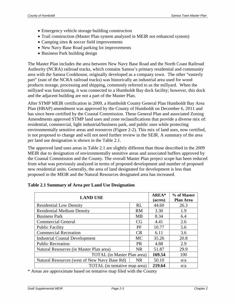
The Master Plan includes the area between New Navy Base Road and the North Coast Railroad Authority (NCRA) railroad tracks, which contains Samoa’s primary residential and community area with the Samoa Cookhouse, originally developed as a company town. The other “easterly part” (east of the NCRA railroad tracks) was historically an industrial area used for wood products storage, processing and shipping, commonly referred to as the millyard. When the millyard was functioning, it was connected to a Humboldt Bay dock facility; however, this dock and the adjacent building are not a part of the Master Plan. After STMP MEIR certification in 2009, a Humboldt County General Plan Humboldt Bay Area Plan (HBAP) amendment was approved by the County of Humboldt on December 6, 2011 and has since been certified by the Coastal Commission. These General Plan and associated Zoning Amendments approved STMP land uses and zone reclassifications that provide a diverse mix of: residential, commercial, light industrial/business park, and public uses while protecting environmentally sensitive areas and resources (Figure 2-2). This mix of land uses, now certified, is not proposed to change and will not need further review in the SEIR. A summary of the area per land use designation is shown in the Table 2.1. The approved land uses areas in Table 2.1 are slightly different than those described in the 2009 MEIR due to designation of environmentally sensitive areas and associated buffers approved by the Coastal Commission and the County. The overall Master Plan project scope has been reduced from what was previously analyzed in terms of proposed development and number of proposed new residential units. Generally, the area of land designated for development is less than proposed in the MEIR and the Natural Resources designated area has increased. Table 2.1 Summary of Area per Land Use Designation
* Areas are approximate based on tentative map filed with the County
LAND USE AREA* (acres)
% of Master Plan Area
Residential Low Density RL 44.60 26.3 Residential Medium Density RM 3.30 1.9 Business Park MB 8.34 6.4 Commercial General CG 4.41 2.6 Public Facility PF 10.77 5.6 Commercial Recreation CR 6.11 3.6 Industrial Coastal Development MC 35.26 20.8 Public Recreation PR 4.88 2.9 Natural Resources (in Master Plan area) NR 51.87 29.9
TOTAL (in Master Plan area) 169.54 100 Natural Resources (west of New Navy Base Rd) NR 50.10 n/a
TOTAL (in tentative map area) 219.64 n/a

County of Humboldt Samoa Town Master Plan
Draft Supplemental MEIR Page 2-4 Chapter 2
Figure 2-1 Samoa Town Master Plan Area

County of Humboldt Samoa Town Master Plan
Admin. Draft Supplemental MEIR Page 2-5 Chapter 2
Figure 2-2 STMP Land Use Map

County of Humboldt Samoa Town Master Plan
Admin. Draft Supplemental EIR Page 2-6 Chapter 2
Residential Residential Low Density/Single-Family [RL/RS] and Residential Multi-Family [RM/RM] – Includes a mix of residential units: single-family, multi-family “workforce housing” units, and live/work studio units. The Master Plan includes a Planned Unit Development, which allow greater flexibility in development standards. Proposed residential development would include a combination of new residential development, as well as renovation of existing residential units as needed, and conversion of existing residential units. There are 99 existing residential units in the town of Samoa. Eighty-eight (88) existing units to remain in residential use. Eight existing units located on Cadman Street, are designated CG for artist live/work studios. The Hostelry and two residences adjacent to the town square are designated for commercial and commercial recreation use; Single-family residential units, on individual lots, would be the predominant form of housing in the Master Plan. New housing areas would be concentrated, primarily, in the central and north areas of the site. A total of 198 new residential units, including up to 80 multi-family housing units located east of Vance Avenue, and south of Soule Street are planned.
Industrial Industrial/Coastal-Dependent [MC] - The majority of the existing Industrial/Coastal Dependent Industrial [MC] designation, located east of the NCRA railroad right-of-way, will remain designated for that use. Approximately 35.3 acres of MC-designated land are to be retained. The MC-designated land is flat, graded, industrial land that was previously the site of the Louisiana-Pacific lumber mill, and formerly the Hammond Lumber Company. Former mill buildings, associated structures and log decks have been removed from the site. Business Park [MB] - The approximately 10.9 acre business park, along the west side of Vance Avenue, is planned for light industrial, warehousing, research and development, showroom, and small business/office uses.
Commercial
Commercial General [CG] – Includes two areas of general commercial land use, totaling approximately 4.4 acres. A central commercial area along Cutten Street (between Vance Avenue and N. Bay View) includes the existing Samoa Block building, retail/office space, restaurants and shops, a town square, two residences converted to commercial use, a renovated gas station, and public parking. The other area of CG land use includes the mini-storage facility at the north end of the site, between Vance Avenue and the NCRA railroad tracks.
Recreation and Conservation
Commercial Recreation [CR] – The Master Plan includes approximately 6.1 acres of commercial recreation. One area at the northeast portion of the site includes the existing Maritime Museum, the Samoa Cookhouse, an existing gymnasium, and parking areas. Additional CR land uses in the existing Samoa Cookhouse area include a proposed RV Park (up to 8-spaces with no hook-ups), and the second story of the Samoa Cookhouse

County of Humboldt Samoa Town Master Plan
Admin. Draft Supplemental EIR Page 2-7 Chapter 2
Motel/Hotel. The existing Hostelry building, on the northwest corner of Rideout Road and North Bay View complete the CR land use. Natural Resources [NR] – Natural areas totaling approximately 50.6 acres include a broad corridor east of New Navy Base Road, the north corner of the site, an area east of Vance Avenue, and several smaller natural resources designated areas located within residential and commercial areas. These NR designated lands contain areas of dunes, wetlands and native vegetation. Setbacks from Environmentally Sensitive Habitat Areas (ESHAs) are proposed and delineated to protect sensitive coastal resources. The area west of New Navy Base Road also remains NR, with 10 additional coastal access parking spaces adjacent to the existing parking area. Public Recreation [PR] – Two areas of PR land use, totaling approximately 4.9 acres, include Samoa Park, the town’s main public park, located east of Vance Avenue. The existing park, which totals 2.9 acres, will have a renovated playground, basketball and tennis courts. The existing soccer field area across Vance Avenue from the park is also be designated PR.
Public Public Facility [PF] – Two main areas of land designated PF, totaling approximately 9.5 acres. The largest area to contain wastewater treatment facilities west of Vance Avenue, south of Soule Street, extending along the north boundary of the business park. Also designated PF to contain the primary wastewater treatment plant, a water tank and new emergency services vehicle storage building, located at the Vance Avenue and Samoa Street intersection. This vehicle storage facility to serve as an emergency evacuation area.
Roadways, Bike Trail, and Pathways - The two existing Master Plan entry points, the
Cookhouse Road/New Navy Base Road intersection and the Samoa Pulp Lane (formerly LP Drive)/New Navy Base Road intersection, would remain. Vance Avenue would continue as the main north-south access for the Master Plan. Road design and construction would be required to comply with County standards and satisfy Design Guidelines. Bike trails and pathways throughout the Master Plan area are also proposed. The existing pedestrian underpass under New Navy Base Road to remain, for non-motorized town to beach access.
Proposed Master Plan Phasing The Samoa Town Master Plan is proposed to be implemented in phases. Initial development phases will include constructing wastewater treatment facility and Vance Avenue improvements, constructing the proposed multi-family housing, and upgrading and renovating existing structures in the town. Development of new single-family residential and non-residential uses are planned for the later phases.

County of Humboldt Samoa Town Master Plan
Admin. Draft Supplemental EIR Page 2-8 Chapter 2
2.5 WASTEWATER DISPOSAL ALTERNATIVE This Supplemental EIR includes discussion and analysis of treated wastewater conveyance from the Samoa treatment facility to the existing ocean outfall pipe at the Humboldt Bay Harbor District’s Redwood Marine Terminal (RMT) II (SMEIR Section 4.1) and disposal through the outfall. This alternative considers the construction and use of an approximately 4,000 foot long pressurized 6-inch PVC effluent pipeline constructed and installed in the Vance Avenue roadway alignment (Figure 2-3). It also considers the discharge of up to 53,000 gallons per day (gpd) of treated wastewater from Samoa treatment facility to the existing ocean outfall at RMT II. This wastewater disposal alternative is being analyzed in part, due to an application on file at the Regional Water Quality Control Board (RWQCB). In 2017, RWQCB representatives, and other Peninsula group interests met to discuss submittal of a Report of Waste Discharge Permit, for use of the existing ocean outfall for Samoa’s treated effluent. The 2009 MEIR considers onsite wastewater disposal at the Samoa Townsite. The alternative analysis contained in SMEIR Section 4.1 is solely for the potential effects of the conveyance of treated wastewater in a new 6-inch discharge pipe between the Samoa WWTP and the RMT II ocean outfall, referred to as “ Manhole #5” and disposal of treated wastewater through the ocean outfall. It does not include any analysis of regional wastewater options which are being considered in a separate EIR1. RWQCB consideration of the application for discharge of Samoa treated effluent through the existing outfall pipe is tentatively scheduled for mid to late 2019. The alternative analysis is primarily for the County of Humboldt, as lead agency to consider the Samoa Tentative Map and Coastal Development Permit (CDP) on file at the County. In addition it would also allow the Report of Waste Discharge Permit Application to proceed with the RWQCB. The County has included this alternative to facilitate agency review and to be the extent of CEQA analysis necessary to consider the conveyance and disposal of Samoa treated effluent. 2.6 DEVELOPMENT AGREEMENT The applicant is proposing a development agreement be approved concurrently with the tentative map approval. The County has the authority to enter into a development agreement with any
1 County of Humboldt, April 2018. Samoa Peninsula Wastewater Project, Notice of Preparation and Notice of Scoping Meeting for a Draft Environmental Impact Report.
Figure 2-3 Wastewater Disposal Alternative

County of Humboldt Samoa Town Master Plan
Admin. Draft Supplemental EIR Page 2-9 Chapter 2
person/entity having a legal or equitable real property interest providing for property development and establishing certain development rights therein. Key Development Agreement Provisions Key development agreement provisions include2: Vested Right to Develop. It is agreed that the development rights, obligations, terms and conditions specified in this Agreement are fully vested in the Developer and may not be changed, modified, invalidated or otherwise limited by County, whether by administrative action, legislative action, or, to the extent allowed by law, vote of the electorate through initiative, referenda and/or other voting process, except as may be expressly permitted by and in accordance with the terms and conditions of the Development Standards or as expressly consented to by Developer.
Permitted Uses and Development Standards. The Project shall be developed in accordance with the Development Standards. The maximum permitted uses, density and intensity of use, the maximum height and size of proposed buildings, the construction, installation and extension of public and private improvements, subdivision standards, development guidelines and standards, implementation program for processing of Subsequent County Approvals, and other conditions of development for the Project Site shall be those set forth in the Development Standards. Life of Parcel Maps, Subdivision Maps, County Approvals, Subsequent County Approvals and Permits. Except as otherwise required by law, any discretionary land use approval for the Project, including tentative maps, shall be automatically extended for the Term of this Agreement, by the County, if not otherwise vested by substantial construction. Timing of Development and Phasing; Effect of Pardee Decision. Because the California Supreme Court held in Pardee Construction Co. v. City of Camarillo (1984) 37 Cal.3d 465, that failure of the parties to provide for the timing of development resulted in a later-adopted initiative restricting the timing of development to prevail over the parties’ agreement, it is the intent of the Developer and County to cure that deficiency by acknowledging and providing that Developer shall have the right (without the obligation) to develop the Property in such order and at such rate and at such time as it deems appropriate within the exercise of its subjective business judgment, subject to the terms of this Agreement. Phasing shall be in accordance with the Board of Supervisors and Planning Commission approvals as may be amended. Compliance with CEQA. The Parties acknowledge that the Final EIR prepared for the Project complies with CEQA. The Parties further acknowledge that (i) the Final MEIR contains a thorough analysis of the Project and possible alternatives to the Project, (ii) The Mitigation Measures have been adopted to eliminate or reduce to an acceptable level certain adverse environmental impacts of the Project, and (iii) the Board of Supervisors adopted a statement of overriding considerations in connection with the Project, pursuant to CEQA Guidelines Section 2 The above summary is taken from the draft agreement between the County of Humboldt and Samoa Pacific Group. The agreement may be modified in the course of public hearings to be conducted by the Humboldt County Planning Commissioners and Board of Supervisors before final adoption.

County of Humboldt Samoa Town Master Plan
Admin. Draft Supplemental EIR Page 2-10 Chapter 2
15093, for those significant impacts that could not be mitigated to a less than significant level. The Final EIR for the Project is intended to be used in connection with each of the Subsequent County Approvals needed for the Project consistent with the Public Resources Code and the CEQA Guidelines, which streamlines the review of the Project and reduces the need to prepare repetitive environmental studies. Consistent with the CEQA policies and requirements applicable to the EIR, the EIR will be used to the fullest extent allowed by law in connection with the processing of any Subsequent County Approval. Additional environmental review may only be required by County, in strict conformity with the terms and intent of the Public Resources Code and the CEQA Guidelines. Changes to Development Standards. Only the following changes to the Development Standards shall apply to the development of the Project Site.
Development of the Project Site shall be subject to the rules, regulations, ordinances, and official policies applicable to such development on the Effective Date of Agreement or as will become effective pursuant to the Development Standards and Subsequent County Approvals. To the extent any future changes in the plans, zoning, ordinances, or any future rules, ordinances, regulations, or policies adopted by County purport to be applicable to the Project, the terms of the Agreement shall prevail, unless the Parties thereto mutually agree to amend or modify the Agreement. The Agreement shall not prevent the County, in subsequent actions applicable to the Property, from applying new rules, regulations, and policies which do not conflict with the terms and conditions of the Agreement, nor shall the Agreement prevent the County from denying or conditionally approving any subsequent development application on the basis of such existing or new rules, regulations, and policies. In the event State or federal laws or regulations enacted after the effective date of the Agreement prevent or preclude compliance with one or more provisions of the Agreement, such provisions of the Agreement shall be modified or suspended as may be necessary to comply with such State or federal laws or regulations. Authority of County. This Agreement shall not be construed to limit the authority or obligation of County to hold necessary public hearings, or to limit discretion of County or any of its officers or officials with regard to rules, regulations, ordinances, laws and entitlements of use which require the exercise of discretion by County or any of its officers or officials, provided that subsequent discretionary actions shall comply with the Applicable Rules and shall not unreasonably prevent or delay development of the Property. Nothing in this Agreement shall preclude the County from taking those actions it deems necessary and essential to protect public health and safety; to the extent such actions are inconsistent with the County Approvals, however, the County’s actions shall be narrowly tailored to address the identified public health and safety concern, and the County shall minimize any inconsistency with the County Approvals. Term. The term of this Agreement shall commence upon the Effective Date and shall extend 30-years until December 31, 2046 or ninety (90) days following the “Project Build-out” as

County of Humboldt Samoa Town Master Plan
Admin. Draft Supplemental EIR Page 2-11 Chapter 2
hereinafter defined, whichever is earlier. This Agreement may be extended by the mutual consent of the Parties hereto. For purposes of this Agreement, “Project Build-out” shall mean the date on which the permit final inspection (or comparable instrument) is completed for the last Project improvement or residential home or other structure to be constructed pursuant to the STMP. These provisions are based upon the analysis undertaken in the certified Master EIR and will not result in new environmental effects. 2.7 INTENDED SUPPLEMENTAL MEIR USES This SMEIR analyzes new information of substantial importance or substantial changes in the project or in circumstances under which the project will be implemented that could potentially result in new or substantially more significant impacts not previously analyzed, and if so, whether there are additional feasible mitigation measures that would eliminate such impacts or reduce them to less than significant. This document serves as an informational document. Additionally, this SMEIR, together with the 2009 MEIR, will provide the primary source of environmental information for the lead agency to consider when exercising permitting authority or approval power related to implementing subsequent projects as part of the Samoa Town Master Plan. This SMEIR is intended to provide decision-makers and the public with information that enables them to intelligently consider the environmental consequences of proposed actions. In a practical sense, EIRs function as a technique for fact-finding, allowing an applicant or developer, concerned citizens, agency staff, and decision-makers an opportunity to collectively review and evaluate baseline conditions and project impacts through a process of full disclosure. 2.8 REQUIRED APPROVALS The County is the lead agency for the project. The 2009 MEIR together with this SMEIR are anticipated to be used by the County to evaluate the environmental impacts created by implementation of the Samoa Town Master Plan as it reviews subsequent projects within the scope of the Master Plan, and specifically in the review of the project’s required Coastal Development Permit. The Board of Supervisors will consider approval of the subsequent projects anticipated in the Master Plan as part of the County’s development review process and would certify the project’s Final SMEIR in advance of future project approvals. The Master Plan has received the following approvals and entitlements:
• County General Plan Amendment (GPA)/Zoning Reclassification (ZR), approved on December 6, 2011 (GPA-02-01/ZR-02-02).
• California Coastal Commission Local Coastal Program (LCP) Amendment, conditional approval on March 10, 2011 (LCP Amendment HUM-MAJ-01-08).
• General Plan Amendment and zone reclassification petition approved by Board of Supervisors April 8, 2014 and Coastal Commission May 12, 2016

County of Humboldt Samoa Town Master Plan
Admin. Draft Supplemental EIR Page 2-12 Chapter 2
This SMEIR and the subjects analyzed herein assist the County in considering the environmental effects of the phased Tentative Map (TM) and Coastal Development Permits (CDP) and a proposed wastewater conveyance and disposal alternative. In addition to the County, other responsible agencies whose review and/or approval may be required for the TM and CDP include, but are not necessarily limited to:
• California Coastal Commission • Regional Water Quality Control Board • California Department of Fish and Wildlife • U.S. Fish and Wildlife Service • U.S. Army Corps of Engineers

County of Humboldt Samoa Town Master Plan
Draft Supplemental EIR Page 3-1 Chapter 3
CHAPTER 3
ENVIRONMENTAL ANALYSIS 3.0 ENVIRONMENTAL ANALYSIS This Chapter of the SMEIR describes the project’s environmental setting, evaluates the project’s potential environmental impacts, and, where feasible, sets forth mitigation measures to avoid or substantially reduce any significant adverse effects of the project. This Supplemental EIR updates the 2009 MEIR and subsequent environmental documents, including the County of Humboldt’s Mitigated Negative Declaration for the Multi-family Housing, Wastewater Treatment Facilities, and Vance Avenue Reconstruction Project (State Clearinghouse # 2003052054) by analyzing substantial changes in the circumstances under which the project would be undertaken and new information that was not known and could not have been known at the time the 2009 MEIR was certified, which may result in new or substantially more severe significant impacts than were analyzed in the 2009 MEIR. The analysis is limited to the following seven impact areas:
• Cultural (Historic and Pre-Historic) Resources (Section 3.1) • Biological Environment (Section 3.2) • Greenhouse Gas Emissions (Section 3.3) • Transportation (Section 3.4) • Energy (Section 3.5) • Aesthetics (Section 3.6) • Wildfire (Section 3.7)
All other topics were adequately analyzed in the 2009 MEIR and require no further analysis. CEQA Guidelines Section 15163(b) states that a supplement to an EIR need contain only the information necessary to make the previous EIR adequate for the project as modified. Consistent with the CEQA Guidelines, this SEIR identifies and focuses on the proposed project changes that could result in new or substantially more severe significant direct and indirect effects on the physical environment that were not analyzed in the 2009 Certified EIR. Updates to the environmental setting, regulatory setting, impact, and mitigation discussions in this chapter are provided only where information or project components have been modified and where discussion of these changes is necessary to provide sufficient analysis of impacts.

County of Humboldt Samoa Town Master Plan
Draft Supplemental EIR Page 3.1-1 Chapter 3
3.1 CULTURAL RESOURCES Background & Introduction The 2009 MEIR evaluated the potential for project implementation to affect cultural resources including: potential disturbance to known and unknown archaeological resources, demolition of historic resources, rehabilitation of existing structures, conversion of existing buildings to new uses, relocation of existing buildings or structures, construction of new buildings within the area of historic resources (both residential and non-residential), alterations to landscape features within the area of historic resources, transformation of character and purpose of historic town, subdivision of town and sale to individual owners, construction outside the area of historic resources, and impacts to the potential historic district. Design Guidelines for the Town of Samoa have been adopted by the County to mitigate against impacts on potential historic resources. The Design Guidelines apply to all rehabilitation, reconstruction, demolition, and new development in the Master Plan area. For the purposes of this SMEIR section, new cultural resources information is added since MEIR certification. The discussion and analysis below includes review of the recently completed Phase 2 Archeological Report and the Memorandum of Agreement between the County, the Applicant, and Tribes; and considers Tribal Cultural Resources. This section also focuses on potential impacts associated with historic resources demolition. The analysis in the 2009 MEIR as to all other potential cultural resource impacts remains valid. Environmental/ Regulatory Setting Environmental Setting Section 2.1 of the 2009 MEIR, incorporated by reference here, describes the archaeological and historic overview of the project area. The environmental setting, including descriptions of existing cultural resources identified in the Master Plan site and vicinity remain as described in the 2009 MEIR. Historic resources identified on the Master Plan site are summarized below. The California Office of Historic Preservation and the National Park Service recognize a range of resource types including: buildings, objects, structures, sites and districts. Districts may include all of these first four resource types as well as significant landscape features. These resource types, as well as significant landscape features, may collectively be potentially eligible as a historic district. A resource that meets standards for inclusion on the California Register (see Applicable Plans, Policies, Codes and Regulations below) is regarded as potentially eligible for the Register. CEQA treats properties that are eligible for the Register but not listed on the Register in exactly the same way as designated historic resources. The potentially eligible resources identified in the survey of the Samoa Master Plan Area include: a district surrounding the historic mill town of Samoa and four archaeological sites. One of the archaeological sites has been defined as a component of the potential historic district; the

County of Humboldt Samoa Town Master Plan
Draft Supplemental EIR Page 3.1-2 Chapter 3
remaining three are potentially eligible for listing as individual resources. Therefore, a total of four resources were identified as eligible for the California Register. One of these four, the potential historic district area, includes 227 buildings, structures and sites. While at least a portion of the Master Plan Area would be potentially eligible to be a historic district, no historic district is proposed as part of the Master Plan. Regulatory Setting The legislature added the new requirements regarding tribal cultural resources in Assembly Bill 52 (Gatto, 2014). By including tribal cultural resources early in the CEQA process, the legislature intended to ensure that local and Tribal governments, public agencies, and project proponents would have information available, early in the project planning process, to identify and address potential adverse impacts to tribal cultural resources. By taking this proactive approach, the legislature also intended to reduce the potential for delay and conflicts in the environmental review process.
The Public Resources Code establishes that “[a] project with an effect that may cause a substantial adverse change in the significance of a tribal cultural resource is a project that may have a significant effect on the environment.” (Pub. Resources Code, § 21084.2.) These rules apply to projects that have a notice of preparation for an environmental impact report or negative declaration or mitigated negative declaration filed on or after July 1, 2015. Public Resources Code § 21074 defines “tribal cultural resources.” In brief, in order to be considered a “tribal cultural resource,” a resource must be either: (1) listed, or determined to be eligible for listing, on the national, state, or local register of historic resources, or (2) a resource that the lead agency chooses, in its discretion, to treat as a tribal cultural resource. Public Resources Code§ 21074 defines “tribal cultural resources” as follows: (a)“Tribal cultural resources” are either of the following:
(1) Sites, features, places, cultural landscapes, sacred places, and objects with cultural value to a California Native American tribe that are either of the following: (A) Included or determined to be eligible for inclusion in the California Register of
Historical Resources. (B) Included in a local register of historical resources as defined in §5020.1 subdivision (k).
(2) A resource determined by the lead agency, in its discretion and supported by substantial evidence, to be significant pursuant to criteria set forth in §5024.1 subdivision (c). In applying the criteria set forth in §5024.1subdivision (c) for the purposes of this paragraph, the lead agency shall consider the significance of the resource to a California Native American tribe.
(b) A cultural landscape that meets the criteria of subdivision (a) is a tribal cultural resource to the extent that the landscape is geographically defined in terms of landscape size and scope.
(c) A historical resource described in §21084.1, a unique archaeological resource as defined in §21083.2 subdivision (g), or a “nonunique archaeological resource” as defined in §21083.2 subdivision (h) may also be a tribal cultural resource if it conforms with subdivision (a) criteria.

County of Humboldt Samoa Town Master Plan
Draft Supplemental EIR Page 3.1-3 Chapter 3
Public agencies shall, when feasible, avoid damaging effects to any Tribal cultural resource. (Pub. Resources Code, §21084.3 (a).) If the lead agency determines that a project may cause a substantial adverse change to a tribal cultural resource, and measures are not otherwise identified in the consultation process, new provisions in the Public Resources Code describe mitigation measures that, if determined by the lead agency to be feasible, may avoid or minimize the significant adverse impacts. (Pub. Resources Code, § 21084.3 (b).) Examples include: (1) Avoidance and preservation of the resources in place, including, but not limited to, planning
and construction to avoid the resources and protect the cultural and natural context, or planning greenspace, parks, or other open space, to incorporate the resources with culturally appropriate protection and management criteria.
(2) Treating the resource with culturally appropriate dignity taking into account the tribal cultural values and meaning of the resource, including, but not limited to, the following: (A) Protecting the cultural character and integrity of the resource (B) Protecting the traditional use of the resource (C) Protecting the confidentiality of the resource
(3) Permanent conservation easements or other interests in real property, with culturally appropriate management criteria for purposes of preserving or utilizing the resources or places
(4) Protecting the resource (Ibid.) The following applicable policies were added to the Humboldt Bay Area Plan, as part of the STMP General Plan (Local Coastal Plan) Amendment approval.
STMP (Community Character/Visual) Policy 2: The Design Guidelines for Old Samoa dated March 4, 2007 are hereby incorporated as standards for development within the STMP-LUP overlay designation and are attached as an Appendix to the certified LCP and any changes or revisions to the Design Guideline shall require an amendment of the LCP. Where a conflict arises between the policies of the STMP-LUP overlay designation and the policies of the Design Guidelines, the policies of the STMP-LUP overlay designation shall take precedence. STMP (Community Character/Visual) Policy 4: The demolition or relocation of, any structure that is at least fifty (50) years old and located on lands subject to the STMP-LUP Samoa shall not be considered a principal permitted use and shall require a coastal development permit that is subject to at least one noticed public hearing and is appealable to the Coastal Commission pursuant to Section 30603 of the Coastal Act. No permit to demolish or relocate any structure contributing to the community character and historic context of Samoa shall be approved unless compelling evidence exists that the structure cannot feasibly be restored in place.
Impacts & Mitigation Measures The analysis in this section focuses on the potential impacts associated with demolition of historic resources and potential disturbance to known and unknown archaeological resources or tribal cultural resources. For the purposes of this SMEIR, implementation of the project may have a significant adverse impact on cultural resources if it would cause:

County of Humboldt Samoa Town Master Plan
Draft Supplemental EIR Page 3.1-4 Chapter 3
• Substantial adverse change in the significance of a historic resource. • Substantial adverse change in the significance of known or unknown archaeological
resources or tribal cultural resources.
Impact 3.1.1: Demolition of Historic Resources Discussion: The portion of the Master Plan area that is an eligible historic district includes a total of 227 buildings, structures, and sites. Of these, 194 have been evaluated as contributing resources and 33 as non-contributing resources. For a complete listing of contributing and non-contributing resources identified in the Master Plan area see 2009 MEIR Table 4.1.2. The tentative map implementation would result in proposed lot lines through outbuildings – subdivision regulations would require setbacks/firewalls, both of which are infeasible due to building conditions. For this reason, the demolition of eleven outbuildings that have been identified as contributing resources is proposed, to allow for the creation of individual lots for the existing residences. Table 3.1.1 below lists the outbuildings proposed for demolition. The resource names are listed as they are recorded on State of California Department of Parks and Recreation Primary Record Forms (DPR 523 A). Complete Primary Record forms, including a photo of each resource, are attached to the survey entitled Cultural Resources Survey of the Samoa Town Master Plan Site (see Technical Report on file at the Humboldt County Community Development Services Department). The outbuildings are identified as eligible for listing as a contributor to an eligible district; however, they were not identified as eligible individually. Table 3.1.1 Contributing Outbuildings Proposed for Demolition
Resource Name Status Code1 Contributing Status Resources With Street Addresses 13, 15, 17 Cadman Court & 12, 14, 16 Vance Ave outbuilding
3D, 3CD Contributing
2 Cutten Street outbuilding 3D, 3CD Contributing 110-112 Rideout Street outbuilding 3D, 3CD Contributing 9 Samoa Court Extension outbuildings (two)2 3D, 3CD Contributing 127 Sunset Avenue outbuildings (two) 3D, 3CD Contributing 122 Sunset Avenue outbuilding 3D, 3CD Contributing 1-3 Sunset Avenue Extension outbuilding 3D, 3CD Contributing 8-10 Vance Avenue outbuilding 3D, 3CD Contributing 18-20 Vance Avenue outbuilding 3D, 3CD Contributing
1 Status Codes: 3D - Appears eligible for the National Register (N.R.) as a contributor to a N.R. eligible district through survey evaluation. 3CD - Appears eligible for the California Register (C.R.) as a contributor to the C.R. eligible district through survey
evaluation. 2 At the time of Master EIR certification (2009) there were three outbuildings associated with 9 Samoa Ct. Extension, two of which were determined to be contributing structures, one on proposed lot 66 and one on proposed lot 68. The two structures were in poor condition and one was partially destroyed by fire. The outbuildings were removed sometime between May 2014 and May 2016. The remaining outbuilding associated with the site is located on proposed lot 62, and was included in the outbuilding study referenced below, is not proposed for removal.

County of Humboldt Samoa Town Master Plan
Draft Supplemental EIR Page 3.1-5 Chapter 3
A civil engineering assessment of each outbuilding proposed for demolition has been prepared including photos, a description of construction materials, foundation type, structure (type of framing), roof style, exterior materials, and structural integrity. Plot plans and supporting notes/calculations have been prepared that either justify relocating the building(s) or removing them entirely due to their dilapidated state. See Appendix B for Town of Samoa Contributing Outbuilding Study. Table 3.1.2 summarizes the construction materials, size, current condition, and proposed action for each outbuilding. Table 3.1.2: Summary of Outbuildings Proposed for Demolition1
Construction Materials Approx. Size
Current Condition Proposed Action
Address: 13, 15, 17 Cadman Ct. 12, 14, 16 Vance Ave. - Proposed Lot No.’s: 38, 39, 40, 48, 49, 50 Frame type: wood Foundation: post & pier Siding: wood horizontal tongue and grove Roof: shingle
98 ft. x 13 ft. (1,274 ft2)
Advanced deterioration; broken trusses; structural failure of roof and sides. Building is not structurally sound and considered a hazard. Wood could not be re-used if torn down with intention of reconstruction.
Proposed removal due to structural failure and its long narrow shape spanning 6 lots.
Address: 2 Cutten St. - Proposed Lot No.’s: 45, 46 Frame type: wood Foundation: post & pier Siding: plywood Roof: shingle
21 ft. x 13 ft. (273 ft2)
Structure in poor condition, significant dry rot throughout; newer shingles, intact siding. Could not be moved as the floor diaphragm would not be able to hold the building together and will not structurally support the acting downward and lateral forces. Due to wood type and age, tearing down and rebuilding is not viable.
Proposed removal due to poor structural condition and it’s bisected by a proposed property line.
Address: 110-112 Rideout St. – Proposed Lot No.’s: 106, 107 Frame type: wood Foundation: post & pier Siding: vertical board & batten and horizontal wood tongue & groove Roof: shingle
19 ft. x 15 ft. (285 ft2) (with an attached 16 ft. x 11 ft. overhang)
Structure in poor condition; interior roof trusses are failing; exterior walls in disrepair. Building would fall apart upon attempting to move it. Building materials in extremely poor shape and could not be re-used.
Proposed removal due to poor structural condition and it’s bisected by a proposed property line.
Address: 127 Sunset Ave. - Proposed Lot No.’s: 83, 84 (two outbuildings) Frame type: wood Foundation: post & pier Siding: horizontal wood tongue & groove Roof: tarpaper
18 ft. x 15 ft. (270 ft2)
Structure and roof in poor condition; cracked siding; missing window panes. Would not withstand the significant forces imposed by attempting to move it. Wood framing could not be re-
Proposed removal due to poor structural condition and it’s bisected by a proposed property line.

County of Humboldt Samoa Town Master Plan
Draft Supplemental EIR Page 3.1-6 Chapter 3
Construction Materials Approx. Size
Current Condition Proposed Action
Frame type: wood Foundation: post & pier Siding: plywood Roof: tarpaper
16 ft.x12.5 ft. (200 ft2)
used if torn down with intention of rebuild. Building in fair condition; considerable paint missing, but otherwise relatively sound.
Proposed relocation as it is bisected by a proposed property line.
Address: 122 Sunset Ave. – Proposed Lot No.: 308 Frame type: wood Foundation: wood on one half, supported by a combination cantilever wood bracing system along the back side Siding: horizontal wood tongue & groove Roof: shake and tarpaper
44 ft. x 13 ft. (572 ft2)
Two separate roof structures, the shake part is in poor condition with broken fascia. Structure in poor condition with failing foundations. The building is a hazard and unsafe for occupancy and usage.
Proposed removal due to unsafe conditions and would result in a zero setback from proposed property line.
Address: 1-3 Sunset Ave. Extension – Proposed Lot No.’s: 98, 99 Frame type: wood Foundation: post & pier Siding: horizontal wood tongue & groove Roof: tarpaper
18 ft. x 11 ft. (198 ft2)
Roof is ruined and growing a significant amount of moss; sides are not square and the building is not plumb. Could not by moved or rebuilt.
Proposed removal due to poor structural condition and it’s bisected by a proposed property line.
Address: 8-10 Vance Ave. – Proposed Lot No.’s: 42, 43 Frame type: wood Foundation: post & pier Siding: shake Roof: shingle
26 ft. x 18 ft. (468 ft2)
Roof is in good condition; windows are missing or have been boarded; siding in poor condition; foundation is elevated due to topography and is no longer structurally sound.
Proposed removal due to poor structural condition and its bisected by a proposed property line.
Address: 18-20 Vance Ave. – Proposed Lot No.’s: 37, 50, 51 Frame type: wood Foundation: post & pier Siding: vertical board & batten Roof: part shake, part corrugated metal
39.5 ft. x 14 ft. (553 ft2)
Roof, foundation, and paint are in poor condition; walls are no longer plumb and beginning to fall in on themselves. Roof trusses inside the building are failing and the foundation is in very poor condition. Building materials are rotting and could not be re-used.
Proposed removal due to poor structural condition and would be located on three proposed lots.
1 Source: Town of Samoa Contributing Outbuilding Study, January 28, 2013 (Appendix B). In order to meet setback requirements and create individual lots for the existing residential structures in the Town of Samoa, the outbuildings described above would require removal (except for one of the outbuildings located at 127 Sunset Ave. which could be relocated). As described

County of Humboldt Samoa Town Master Plan
Draft Supplemental EIR Page 3.1-7 Chapter 3
above, the outbuildings lack adequate structural integrity for on-site relocation and have deteriorating building materials. These outbuildings represent a small fraction (approximately 5%) of the 194 contributing resources identified within the eligible historic district. They are all accessory structures to existing residences. While the applicant has submitted information supporting the proposed demolitions, the identified outbuildings are identified as contributing buildings in the Cultural Resources Survey of the Samoa Town Mater Plan Site.1 Potential significant impacts arising from proposed outbuilding demolition would include loss of an existing structure with cultural, historic, and architectural associations with the company town. Determination: Demolition of contributing buildings is a significant and unavoidable historic resources impact. Mitigation: The following mitigation measures are taken directly from the 2009 MEIR. Modifications to the original mitigation measures are identified in strikeout text to indicate deletions and underline to signify additions. 2009 MEIR Mitigation Measure 4.1.2a: Any contributing historical structure shall be assessed for its relative importance and its current conditions for rehabilitation. Consideration shall be given to reasonable preservation alternatives that do not create an economic hardship within the overall Samoa Master Plan effort. Economic hardship can be defined as, the cost of restoration or rehabilitation work outweighs the value of the structure. These alternatives will include the review of the building’s reconstruction and an appropriate use compatible with the Samoa Master Plan directives. Rehabilitation shall be carried out consistent with Design Guidelines and mitigation measures 4.1.3a-b and 4.1.5a-c shall be followed. Historic American Building Survey standards for documenting contributing resources will be employed prior to demolition of a contributing resource. 2009 MEIR Mitigation Measure 4.1.2b: While not proposed as part of the Master Plan, future owners should consider conservation easements to protect facades and property tax reductions as preservation alternatives prior to demolition of a historic resource. 2009 MEIR Mitigation Measure 4.1.2c: Demolition of the Fireman’s Hall and any other structures identified as contributing resources by the Cultural Resources Survey must be preceded by preparation of a Historic American Building Survey (HABS) Report to the standards set out by the Secretary of the Interior, for a permanent record of the building and its history. 2009 MEIR Mitigation Measure 4.1.2d: Measures to minimize potential impacts of new development on adjacent contributing historic resources must be implemented. These shall include siting, design and screening of new buildings, consistent with Design Guidelines, including compatible building height, scale, materials, roof and wall mass and articulation. 1 The Cultural Resources Survey of the Samoa Town Mater Plan Site is on file with the Humboldt County Planning & Building Department.

County of Humboldt Samoa Town Master Plan
Draft Supplemental EIR Page 3.1-8 Chapter 3
2009 MEIR Mitigation Measure 4.1.2e: Site the soccer arena building or parking structures to be sited in such a way that the row of cypress trees can be retained and that proposed buildings will be subordinate to the Samoa Cookhouse and other contributing structures. (The soccer arena is no longer part of the project, there are no structures proposed for this location; therefore the mitigation measure not required). 2009 MEIR Mitigation Measure 4.1.2f: The SDRC has the authority to review applications to demolish a structure and determine whether a unique situation for demolition exists, per the Design Guidelines and County Ordinance. 2009 MEIR Mitigation Measure 4.1.2g: Prior to the demolition of the fireman’s hall the following shall occur:
Photo-documentation using the Historic American Building Survey (HABS) or alternative standards,
Documentation shall be organized for use as an educational exhibit, archival collection retrieval oral history documentation, or interpretive programs for public use,
Salvage of building elements for appropriate use in other areas of the Master Plan. Level of Significance after mitigation. The impact remains significant. Under CEQA, determination of a significant and unavoidable impact requires a statement of overriding consideration. In determining potential significance of impacts, it was determined that alternatives to demolition, that would reduce or minimize potential impacts (to a less than significant level),were considered, and determined to be infeasible due to cost and condition of structures. Impact 3.1.2: Potential Disturbance to Known and Unknown Archaeological Resources or Tribal Cultural Resources Discussion: A cultural resources survey was prepared and included as an appendix to the certified MEIR and identifies all known tribal resource sites in the STMP area2. The 2004 Heald et al. survey reported four archeological sites which include one Native American archaeological site (Samoa Site 1), one historic era site (Samoa Site 2) and two multi-component sites with both Native American and historic era archaeological deposits (Samoa Sites 3 and 4). At that time the California Register eligibility of these sites was difficult to evaluate based on surface observation, and it was possible that some or all of the sites contained intact subsurface deposits. It was therefore noted further testing during a Phase II Archeological Survey would be necessary to determine the eligibility of the sites. As a result of consultation with local tribal groups (Bear River Band of Rohnerville Rancheria, Blue Lake Rancheria, and Wiyot Tribe), a Memorandum of Agreement (MOA) for Cultural
2 Heald, Leslie; Suzanne Guerra, and Amanda Cannon, 2004. Cultural Resources Survey of the Samoa Town Master Plan Site. Prepared for Planwest Partners, Arcata, CA 95518. Edited by Rene Vellanoweth. On file at the Humboldt County Planning & Building Dept.

County of Humboldt Samoa Town Master Plan
Draft Supplemental EIR Page 3.1-9 Chapter 3
Resource protection was entered into by the three local tribes, the County, and the property owner, Samoa Pacific Group (SPG). During the winter of 2017/2018, Roscoe and Associates (RA) conducted Phase 2 archaeological significance evaluations (per CEQA criteria) at the four sites identified above.3 Generally, a resource shall be considered by the lead agency to be “historically significant” if the resource meets the criteria for listing on the California Register of Historical Resources (PRC 5024.1, Title 14 CCR, Section 4852) including resources: associated with events that have made a significant contribution to the broad patterns of California’s history and cultural heritage (Criterion A); associated with the lives of persons important in our past (Criterion B); that embody the distinctive characteristics of a type, period, region, or method of construction, or represents the work of an important creative individual, or possesses high artistic values (Criterion C); or has yielded, or may be likely to yield, information important in prehistory or history (Criterion D). In order to assess the historical significance of Samoa Sites 1, 2, 3 and 4, RA conducted background archival research to establish historical context, correspondence with Native American tribal representatives, archaeological test excavations and artifact and ecofact analysis. Archaeological field survey and subsurface testing of the four previously identified archaeological sites was conducted by RA between June and December 2017; THPO Erika Cooper and THPO Assistant Robert Pepetone, acted as cultural monitors and were present during the fieldwork. Phase II Archaeological Evaluation Findings A summary of findings and recommendations contained in the RA Phase 2 Archeological Evaluation is provided below. Specific site information is confidential and on file with the County. Samoa Site 1 does appear to contain data potential and more focused excavations at this site could assist researchers in answering questions important in understanding our past, including one of the major research themes for northwestern California regarding the origin of intensive coastal adaptations and the relatively late emergence of ocean dominated subsistence strategies. For these reasons RA recommends that Samoa Site 1 be considered an historical resource, eligible for the California Register of Historical Resources (CRHR) under Criterion D. The RA survey of Samoa Site 2 found no evidence of the previously reported artifacts and ecofacts, despite a thorough pedestrian field survey and the excavation of shovel probe units. For the purposes of this investigation, Samoa Site 2 should be treated as a contributor to the potentially eligible Samoa Historic District. Although clearly disturbed, Samoa Site 3 still appears to contain data important in understanding our past. For this reason, RA recommends that Samoa Site 3 be considered an historical resource, eligible for the CRHR under Criterion D. The historic era components of Samoa Site 3 do not appear CRHR eligible at this time. RA recommends that Samoa Site 4 be considered an historical resource, eligible for the CRHR under Criterion D. Additionally, the historic-era archaeological components of this site may contribute to the historical significance of the potentially eligible Samoa Historic District. Samoa Sites 1, 3 and 4 all appear to be located outside the Master Plan's direct work areas. Samoa Site 2 is located within an area slated to become a parking area, however RA found no evidence of 3 Roscoe and Associates (RA), February 2018. Archaeological Test Excavations and Evaluation of four Sites Identified near the Town of Samoa, Humboldt County, CA. On file with Humboldt County Planning & Building Dept.

County of Humboldt Samoa Town Master Plan
Draft Supplemental EIR Page 3.1-10 Chapter 3
this site where Heald et al. (2004) documented it, in the direct work area. Due to the level of disturbance at these four sites and the limitations set on the field study by existing infrastructure (roads, buildings etc.), intact and or contributing components could be present in their respective site vicinities. For these reasons, RA recommends that archaeological monitoring of ground disturbing construction activities be conducted when operating within 50 feet of these four site boundaries. Per the MOA agreement signed by representatives of the County, the landowner, and three local tribal groups, Wiyot cultural monitors should also be allowed the opportunity to observe ground disturbing activities conducted near these site boundaries. The 2009 MMRP required that SPG shall consult with the Tribes' THPOs and retain a qualified cultural resources consultant versed in regional historic and Native American archaeology to collaboratively develop a formal Archaeological Monitoring Plan and Protocol for Inadvertent Archaeological Discoveries with the Tribes and County during Samoa Town Master Plan (STMP) implementation. The Archeological Monitoring Plan and Protocol for Inadvertent Discoveries has been drafted by the Anthropological Studies Center at Sonoma State University and is currently under final review by the County and THPOs. Determination: Less than significant adverse impact with incorporation of mitigation measures. Mitigation: The following mitigation measures are taken directly from the 2009 MEIR. 2009 Mitigation Measure 4.1.1a: For all known archeological sites not located in areas proposed for development, on-site staking of construction boundaries is required to ensure that all sites are avoided during all construction activities during access and staging phases. 2009 Mitigation Measure 4.1.1b: For known archeological sites that could be impacted during construction, the following mitigation measure(s) shall be implemented to reduce potentially significant to less than significant impacts or no impacts:
1) Adjust proposed plans to completely avoid site boundaries, OR 2) Cap site with appropriate of fill and road base to a height equal to but not less than 12
inches above site surface; OR 3) Implement archeological data recovery procedures involving controlled excavation and
analysis of material by Register of Professional Archeologists (ROPA) eligible archeologists, preferably trained in historical archeology. The archeological data recovery program must meet Research Design and Reporting standards consistent with the California Office of Historic Preservation’s Preservation Bulletin Numbers 4a and 4, and the Secretary of the Interior’s Standards and Guidelines for Archeology and Historic Preservation. The type and nature of the data recovery phase shall be determined by the lead agency in consultation with ROPA eligible archeologists and interested parties but may include: a) Coring and auguring to determine site boundaries and depth;

County of Humboldt Samoa Town Master Plan
Draft Supplemental EIR Page 3.1-11 Chapter 3
b) Exploratory 1 m2 or 4-5 ft2 excavation pit to obtain cross-sectional data on the site’s constituents;
c) Horizontal, open-area coverage of key archeological features found during exploratory excavation. Open area excavations are conducted to reveal the organization of the site including the location of the building foundations, privies, walls/fences, and discrete activity areas. These methods, combined with laboratory analyses of all recovered materials, will yield the important and historically significant information within the site, thereby effectively mitigating adverse effects.
4) Future owners should also consider Deed Restrictions and Conservation Easements for protection of archeological resources.
2009 Mitigation Measure 4.1.1c: Institute an archaeological monitoring program when operating within 50 feet the site boundaries of the four identified archeological sites. All construction activities involving ground disturbance shall be monitored for the presence of archaeological materials. A qualified archaeological monitor and a Native American monitor shall be employed during all ground disturbing activities. If the monitors identify any archaeological sites, ground disturbing activity shall halt while the site is evaluated by qualified archaeologists. If a previously unknown site is evaluated as potentially eligible for the California Register, then appropriate mitigation procedures shall be followed. These procedures shall follow Mitigation Measure 4.1.1b. An archeological data recovery, guided by a professional archeologist, will be required as mitigation. A refined archeological monitoring plan will be developed and implemented as mitigation, with the following components:
• A Sensitivity Map for prehistoric and historic archeological sites; • An Historic Context that identifies related property types and significance thresholds for
historic period and prehistoric archeological deposits; • Treatment standards for data recovery of “discoveries”; • Standards for documentation, reporting, and curation; • Site monitor qualifications, roles, responsibilities and authority; • Tribal Coordination with all three local tribes having Wiyot ancestral ties; • Process for refining the monitoring plan as “discoveries” are reported.
Mitigation Measure 4.1.1d: All mitigation work shall be accompanied by a statement of non-disclosure of sites mitigation, and/or other mitigations completed by the property filed with the North Coast Information Center.

County of Humboldt Samoa Town Master Plan
Admin. Draft Supplemental MEIR Page 3.2-1 Chapter 3
3.2 BIOLOGICAL RESOURCES Background & Introduction This section provides a biological analysis update to the 2009 MEIR, with information from the STMP Updated Biological Resource Study and Supplemental Wetland Delineation, dated May 17, 2019 (Appendix C). The update evaluates potential environmental impacts resulting from proposed STMP changes and/or to environmental changes that may have occurred since Final MEIR certification in 2009 and to determine whether the new information indicates any potentially significant adverse impacts and if so, proposed mitigation. The 2009 MEIR evaluated potential impacts to biological resources affected by the Master Plan. It addresses potential impacts on those resources and identifies measures appropriate to mitigate potentially significant impacts. This section incorporates the 2009 MEIR by reference and includes updated information contained in Appendix C. The Updated Biological Resource Study and Supplemental Wetland Delineation was prepared to satisfy the Humboldt Bay Area Plan (HBAP) policies related to the Samoa Town Master Plan implementation including, but not limited to, STMP (New Development) Policy 1B (Phasing of Development). It builds upon previously conducted surveys in the project area including the Addendum: Samoa Town Master Plan Biological Resource Study, Botanical Survey and Invasive Plant Management Plan, completed in 2013 and referenced here. The 2019 Updated Biological Resource Study and Supplemental Wetland Delineation includes assessment of previously designated Environmentally Sensitive Habitat Areas (ESHA), identification of potential expanded ESHA habitat, updated wildlife survey, updated botanical survey, invasive species survey, and updated wetland delineation. Supplemental wetland delineation and delineation of non-wetland ESHA results confirm the persistence of previously delineated wetland and non-wetland ESHA and document boundary changes of said habitats where they occurred. Environmental & Regulatory Setting Environmental Setting MEIR Section 2.4, incorporated by reference here, describes the project area environmental setting, which is summarized below. The biological setting, including descriptions of Master Plan area habitats and plant and animal communities typical of these habitats, generally remain as described in the MEIR. Existing development includes residential, commercial, and industrial lands associated with historic lumber mill operations and the community of Samoa. Vegetation associated with developed areas consists primarily of introduced species that have become naturalized, or that were planted for landscaping purposes. Developed areas also support various “man-induced” wetlands such as the town’s existing wastewater treatment facility, drainage ditches and vegetated detention basins. Undeveloped portions of the property include habitats such as

County of Humboldt Samoa Town Master Plan
Admin. Draft Supplemental MEIR Page 3.2-2 Chapter 3
coniferous forests, coastal scrub, foredunes, and dune hollow wetlands, most of which occur on undeveloped dunes immediately adjacent to New Navy Base Road. The following upland and wetland habitats have been identified and mapped in the project vicinity: Upland Habitats
• Coastal Coniferous Forest • Northern Coastal Scrub • Northern Foredunes • Beach Strand • Degraded Dunes and Developed Dunes • Urban Landscape • Open Sand
Wetland Habitats
• Dune Hollow Wetlands • “Man-induced” Wetlands • Marine Intertidal Wetlands
Special Status Species and Sensitive Natural Communities Detailed descriptions of the plant communities, species associations, and habitat conditions occurring within the STMP study area were provided in the Samoa Town Master Plan Biological Resource Study (2004), and those characterizations continue to be generally applicable within the timeframe of the 2019 updated study. The potential for special status botanical and wildlife species to occur within the study area using a combination of natural resource database information, the review of aerial photography, and site reconnaissance. “Special status species” are defined by the California Department of Fish & Wildlife (2018) as those “species, subspecies, or Evolutionarily Significant Units (ESU) where at least one of the following conditions applies:
• Officially listed or proposed for listing under the State and/or Federal Endangered Species Acts;
• Taxa considered by the Department to be a Species of Special Concern (SSC); - Taxa which meet the criteria for listing, even if not currently included on any list, as described in Section 15380 of the California Environmental Quality Act Guidelines (more information on CEQA is available at: http://resources.ca.gov/ceqa/guidelines);
• Taxa that are biologically rare, very restricted in distribution, or declining throughout their range but not currently threatened with extirpation;
• Population(s) in California that may be peripheral to the major portion of a taxon’s range but are threatened with extirpation in California;
• Taxa closely associated with a habitat that is declining in California at a significant rate (e.g. wetlands, riparian, vernal pools, old growth forests, desert aquatic systems, native grasslands, valley shrubland habitats, etc.);

County of Humboldt Samoa Town Master Plan
Admin. Draft Supplemental MEIR Page 3.2-3 Chapter 3
• Taxa designated as a special status, sensitive, or declining species by other state or federal agencies, or a non-governmental organization (NGO) and determined by the CNDDB [California Natural Diversity Database] to be rare, restricted, declining, or threatened across their range in California.”
Preliminary investigations included queries of species and habitat occurrence records for the "Eureka" and 8 surrounding U.S. Geological Survey (USGS) quadrangles in the following databases: the U.S. Fish & Wildlife Service’s (USFWS) Information for Planning and Consultation (USFWS 2018a); California Department of Fish & Wildlife’s Natural Diversity Database (CNDDB 2018); the CalFlora database (CalFlora 2018); and the California Native Plant Society’s Online Inventory of Rare, Threatened, and Endangered Plants of California (CNPS 2018a); among others. The potential for “California sensitive natural communities” to occur within the study area was also addressed as part of this process.
Based on the results of this preliminary research, a comprehensive list of special status species and communities that could potentially occur within the study area was developed. This list is provided in Appendix B as a summary table in the 2019 Updated Biological Resource Study, which includes relevant information about each species used to evaluate their relative potential for occurrence within the study area. That comprehensive list was then used to develop appropriate strategies for carrying out subsequent botanical surveys and wildlife habitat assessment fieldwork. Evaluation of each species’ “potential for occurrence” within the study area was made using the criteria described below.
Special Status Botanical Surveys Floristically appropriate field surveys were conducted in 2018 for all development phases of the STMP east and two areas west of New Navy Base Road. A survey of the development areas was performed to update existing resource data for the STMP, as required under the Humboldt Bay Area Plan. The updated information is provided as an update to the 2004 Biological Resource Report and 2013 Addendum to comply with requirements for subdivision and Coastal Development Permit Approval by the County of Humboldt. Prior to conducting field surveys, the list of special-status plants with known occurrence in the project region was updated by performing a query of the California Department of Fish and Wildlife Natural Diversity Database (CNDDB 2018), the California Native Plant Society On-line Inventory of Rare and Endangered Vascular Plants of California (CNPS 2018) for the Eureka 7.5 minute USGS quadrangle and eight adjacent coastal quadrangles (Arcata North, Tyee City, Arcata South, Trinidad, Crannell, Fields Landing, Fortuna, Cannibal Island, and Ferndale), the CalFlora database, and the U. S. Fish and Wildlife Service’s Information for Planning and Consultation. Eight plant species were added to the list generated for the original biological study (2009 MEIR Table 2.4.2). These additions are listed in Table 3.2.1, along with an assessment of their potential for occurrence within the study area. Habitat suitability was evaluated using the following criteria:
Present. The species is known to occur within the study area, based on historical occurrence records and/or recent survey data. High Potential. Habitat components meeting the species requirements are present and most of the habitat on or adjacent to the site is highly suitable. The species has a high probability of being found in the study area.

County of Humboldt Samoa Town Master Plan
Admin. Draft Supplemental MEIR Page 3.2-4 Chapter 3
Moderate Potential. Habitat components meeting the species requirements are present; however, some of the habitat on or adjacent to the site is unsuitable. The species has a moderate probability of being found in the study area. Low Potential. Some habitat components meeting the species requirements are present; however, the majority of habitat on and adjacent to the site is unsuitable. The species has a low probability of being found in the study area. Not Present. Habitat on and adjacent to the site is clearly unsuitable for the species or recent survey data indicates that it currently does not occur within the study area.
Seasonally appropriate surveys were performed on April 18-27, June 4, and July 16-31, 2018. Surveys were conducted for all target plants listed in the original biological study and the additions listed in Table 3.2.1 for which suitable habitat was deemed present. All previously identified occurrences of special status species from 2004, 2009, and 2013 were investigated. The distribution of rare plant occurrences was recorded and mapped using a Trimble Juno GPS device with ArcPad® software. Native Species Field Survey Forms were completed for each rare plant occurrence and a list of species encountered during the field investigation are included in Appendix C. Rare Plant Survey Results Three special status botanical species were encountered during the 2018 botanical surveys. These consisted of two State and Federally Endangered plants: Menzies' wallflower (Erysimum menziesii) and beach layia (Layia carnosa), as well as dark-eyed gilia (Gilia millefoliata), which has a CNPS “Rare Plant Rank” of 1B.2 [CNPS 2018a]). Beach layia and Menzies’ wallflower are California endemics that are both state and federally listed as endangered throughout their limited range. Dark-eyed gilia is not state or federally listed, but it is considered endangered in a portion of its range, rare outside of California, and distributed in a limited number of occurrences. All three are locally common in the dunes on the Samoa Peninsula, where they are typically associated with the native dune mat community, but they also occur along edges and sandy openings of dunes dominated by invasive exotic plants.
Historically documented (Mad River Biologists 2004, 2009; Morrissette 2013) occurrences of the State and Federally Endangered beach layia (Layia carnosa) and dark-eyed gilia (Gilia millefoliata) were relocated on both sides of New Navy Base Road in 2018. Though the current extent of these occurrences varies slightly from previously reported distributions, inter-annual variation (such as was observed) is expected given the annual life history strategy of both species. Both species were relocated within the water/power utility line easement between New Navy Base Road and the former log deck. They were found generally in the same locations as they were in 2003/2004 and 2013 but occupying slightly different representative areas, as shown in Figure 3.2-1. Additional occurrences were observed west of New Navy Base Road across from LP Drive and north of the planned expanded day use area, which are also shown on Figure 3.2-1.

County of Humboldt Samoa Town Master Plan
Admin. Draft Supplemental MEIR Page 3.2-5 Chapter 3
Table 3.2.1 Special-Status Plants Addressed for STMP Botanical Study – 2018 Additions Species Status* Habitat Characteristics (CNDDB/CNPS
2018) Potential for Occurrence
Bryoria spiralifera twisted horsehair lichen
Rare Plant Rank 1B.1 G3/ S1S2
Immediate North Coast coniferous and coastal dune forests, usually on conifers. 0-30m
Moderate-High Potential. Historical records from near study area. More recent occurrence at Lanphere Dunes. Known habitat characteristics.
Cardamine angulata seaside bittercress
Rare Plant Rank 2B.2 G4G5 / S3
North Coast Coniferous Forest, Lower Montane Coniferous Forest. Wet areas, streambanks. 5-515m
Historic record from Freshwater area. Known habitat characteristics Not Present within study area.
Castilleja affinis spp. litoralis Oregon coast paintbrush
Rare Plant Rank 2B.2 G3/ S3
Sandy sites in Coastal Bluff Scrub, Coastal Dunes, Coastal Scrub. 5-255m
Low Potential. Occurs mostly on coastal bluff/scrub. Suitable habitat highly limited in study area. Not found in study area.
Collinsia corymbosa round-headed Chinese-houses
Rare Plant Rank 1B.2 G1/ S1
Coastal Dune. California endemic. 0-20m Moderate Potential. Historic record is unconfirmed. Suitable habitat characteristics. Not found in study area.
Lasthenia californica spp. macrantha perennial goldfields
Rare Plant Rank 1B.2 G3T2/ S2
Coastal Bluff Scrub, Coastal Dunes, Coastal Scrub. 5-185m.
Low Potential. Limited historical record. Known habitat characteristics.
Packera bolanderi var bolanderi seacoast ragwort
Rare Plant Rank 2B.2 G4T4 / S2S3
Coastal Scrub, Northern Coast Coniferous Forest. Sometimes along roadsides. 30-915m
Low Potential. Not found in the study area. Limited habitat potential in northern portion of study area.
Piperia candida white flowered rein orchid
Rare Plant Rank 1B.2 G3 / S3
North Coast Coniferous Forest, Lower Montane Coniferous Forest, Broadleafed Upland Forest. Sometimes on serpentine. 20-1615m
Known habitat characteristics Not Present within study area.
Polemonium carneum Oregon polemonium
Rare Plant Rank 2B.2 G3G4/ S2
Coastal Prairie, Coastal Scrub, Lower Montane Coniferous Forest. 0-1830m
Low Potential. Not found in the study area. Known habitat characteristics. Historical record is unconfirmed.
*TABLE 1 STATUS CODES:
California Rare Plant Ranks:
1B Rare, threatened, or endangered in California and elsewhere 2B Rare, threatened, or endangered in California, but more common elsewhere Corresponding Threat Ranks:
0.1 Seriously threatened in California 0.2 Moderately threatened in California 0.3 Not very threatened in California
CNDDB Element Ranking: Global Ranks G3 Vulnerable G4 Apparently secure, considering populations outside of California G5 Secure, considering populations outside of California T# Infraspecific Taxon Rank State Ranks S1 Very Threatened S2 Imperiled S3 Vulnerable

County of Humboldt Samoa Town Master Plan
Draft Supplemental MEIR Page 3.2-6 Chapter 3
Figure 3.2-1 Rare Plant Map 2018

County of Humboldt Samoa Town Master Plan
Draft Supplemental MEIR Page 3.2-7 Chapter 3
Beach layia requires areas of open sand to colonize and cannot establish itself in the thick vegetative cover of nonnative plants that similarly inhabit the dunes of the plan area. It was observed within foredunes on the west side of New Navy Base Road and remnant native dune mat habitat to the east of New Navy Base Road. Beach layia is often associated with native dune mat species such as coast buckwheat (Eriogonum latifolium), coast goldenrod (Lathyrus littoralis), coastal sagewort (Artemesia pycnocephala), and yellow sand-verbena (Abronia latifolia).
Dark-eyed gilia was observed growing in both native dune mat and degraded foredune habitats on the west side of New Navy Base Road and in the degraded dune complex along the east side of New Navy Base Road. It was primarily found in areas of open sand but was also observed in small openings within the context of European beachgrass (Ammophila arenaria). One previously documented occurrence of dark-eyed gilia in degraded dune habitat in the northern portion of the study area could not be relocated. The area is heavily disturbed by recreation activities that likely made the habitat unsuitable for continued growth. Native associates include dune mat species such as yellow sand-verbena (Abronia latifolia), beach pea (Lathyrus littoralis), beach layia (Layiacarnosa), dune knotweed (Polygonum paronychia) and seashore bluegrass (Poa douglasii). An additional State and Federally Endangered plant species, Menzies’ wallflower (Erysimum mensiesii), was identified during the 2018 survey of the potential expanded day use areas at both northern and southern extremities of the study area. It occurred mostly in native dune mat and degraded Northern Foredune habitats. Menzies’ wallflower was observed growing in foredune habitats north of New Navy Base Road, north of the Samoa Booster Station; and on both sides of New Navy Base Road near LP Drive. Occurrences were often found on dune ridges and slopes both in the northern and southern portions of the study area. Of note is the apparent extirpation of three special status botanical species occurrences previously documented within the study area. The first is a small occurrence of dark-eyed gilia reported by Mad River Biologists (2004) and Morrissette (2013) in the Degraded Dune ESHA in the northern portion of the study area, between the existing residences accessed by Sunset Avenue and Samoa Court, and New Navy Base Road. This location is highly disturbed due to paintball-related recreation activities and this species was not relocated at this location in 2018, despite repeated surveys of the location. Invasive Species An updated invasive species inventory was conducted during the 2018 botanical survey. Fifty different invasive plant species were identified in the study area which is seven more than previously identified. Of these, eight are categorized by the California Invasive Plant Council (Cal-IPC 2018) as being highly invasive (Table 9), 2 more than were described previously (Morrissette 2013). These include European beachgrass (Ammophila arenaria), iceplant (Carpobrotus spp.), jubata grass (Cortaderia jubata), Scotch broom (Cytisus scoparius), French broom (Genista monspessulana), Himalayan blackberry (Rubus armeniacus), English ivy (Hedera helix), and gorse (Ulex europaeus). The abandoned industrial log deck continues to be a source of invasive species due to its highly disturbed nature. Species present in this area have a high potential for dispersing to other areas

County of Humboldt Samoa Town Master Plan
Draft Supplemental MEIR Page 3.2-8 Chapter 3
within the STMP study area. The Invasive Plant Management Plan developed as part of the 2013 study should be followed in order to prevent spread of invasive species from this area. Strategies described in that document should incorporate additional measures to address recently documented invasive plants, which may not have been addressed specifically, therein, upon implementation of the invasive plant management plan. Special Status Animal Species Potentially Occurring in the Master Plan Area Observations made during our 2018 fieldwork confirm the sustained relevance, and current applicability, of the wildlife habitat assessments made by the previous investigators in their original biological resource study (Mad River Biologists 2004). None of the observed changes in the distribution, structural development, and/or species composition of the vegetation are considered to have been sufficient to result in corresponding changes to the potential habitat-wildlife species associations described in the original biological study. The special-status animal species occurring or potentially occurring at or adjacent to the Master Plan area are listed in 2009 MEIR Table 2.4-2 along with their status and habitat characteristics. The Biological Resources Report determined that 28 special-status animal species occur or have the potential to occur at or adjacent to the Master Plan area. These include: Northern red-legged frog (Rana aurora aurora), Northwestern pond turtle (Clemmys marmorata marmorata), brown pelican (Pelecanus occidentalis californicus), double-crested cormorant (Phalacrocrax aurtrozous pallidus), great blue heron (Ardea herodias), great egret (Ardea alba), snowy egret (Egretta thula), black-crowned night heron (Nycitcorax nycticorax), osprey (Pandion haliaetus), white-tailed kite (Elanus leucurus), bald eagle (Haliaeetus leucocephalus), Northern harrier (Circus cyaneus), sharp-shinned hawk (Accipiter striatus), Cooper’s hawk (Accipiter cooperi), merlin (Falco columbarius), American peregrine falcon (Falco peregrinus anatum), Western snowy plover (Charadrius alexandrinus nivosus), long-billed curlew (Numenius americanus), elegant tern (Sterna elegans), short-eared owl (Asio flammeus), Vaux’s swift (Chaetura vauxi), willow flycatcher (Empidonax traillii bresteri), purple martin (Progne subis), bank swallow (Riparia riparia), black-capped chickadee (Parus atricapillus), California yellow warbler (Dendroica petechia brewsteri), pallid bat (Antrozous pallidus), Townsend’s western big-eared bat (Corynorhinus townsendii townsendii), and red tree vole (Arborimus pomo). See the 2009 MEIR and associated Biological Resources Study for further discussion. The Updated Biological Resource Study and Supplemental Wetland Delineation did not conduct species specific surveys in the plan area. Instead, observations were made during botanical surveys that focused on changing habitat conditions that could potentially support the species identified above. Several observations of species were recorded during the survey period and are noted below in Table 3.2.2. Though these detections occurred outside of the extent of the current study area, the significance of depicted observations and their close proximity warranted documentation and consideration. Further elaboration regarding the details and significance of these detections is provided in 2019 Updated Biological Resource Study Appendix A. The updated Biological Resource Study and Supplemental Wetland Delineation determined that habitat considerations made in the original study and EIR are still relevant and that interim changes in habitat conditions do not support changes in potential wildlife-habitat associations.

County of Humboldt Samoa Town Master Plan
Draft Supplemental MEIR Page 3.2-9 Chapter 3
Table 3.2.2: Summary of 2018 Special Status Wildlife Species Detections
Species Observed Observations Northern Red-legged Frog (Rana aurora)
Loafing in concrete drainage feature immediately outside eastern boundary of the study area.
Gret Egret (Ardea alba)
Foraging in dune hollow wetland complex, east of New Navy Base Road; overflights.
Great Blue Heron (Ardea Herodias)
Overflights
Aleutian Cackling Goose (Branta hutchinsii leucopareia)
Overflights
Northern Harrier (Circus hudsonius)
Hunting over native and degraded coastal dune habitats.
Peregrine Falcon (Falco peregrinus anatum)
Hunting, repeated roosting on nearby industrial facilities (outside of the study area), conspecific aggressive interaction during breeding season.
Osprey (Pandeon haliaetus)
5 active nests on utility poles outside of, but nearby (>100’), the study area; copulation observed at nest (4/26/18); nest provisioning.
Black-capped Chickadee (Poecile atricapillus)
Foraging in coastal coniferous forest.
Source: Table 2018 in Updated Biological Resource Study & Supplemental Wetland Delineation Supplemental Wetland Delineation A routine (supplemental) wetland delineation was conducted within the study area between November 18-21, 2018 to identify potential State- and Federal jurisdictional wetlands. All ESHA previously identified within the study area (Mad River Biologists 2004, 2009; 2013) were revisited during 2018 fieldwork and their boundaries were mapped and refined where significant changes have occurred. Remaining portions of the study area were also assessed in 2018 to identify and describe any additional areas that also warranted designation as ESHA. Results from the supplemental wetland delineation and delineation of non-wetland Environmentally Sensitive Habitat Areas (ESHA) confirm the persistence of previously delineated wetland and non-wetland ESHA and document changes in the boundaries of said habitats where they occurred. Changes to previously identified ESHA boundaries were primarily attributable to vegetative development and plant community successional dynamics that have occurred during the 14-year interim since the originally delineation effort (Mad River Biologists 2004) was undertaken. These changes are manifest in the progressive growth and development of the woody vegetation associated with wetland and non-wetland (i.e., Northern Coastal Scrub) ESHA. Where both phenomena have occurred (in both wetland and non-wetland ESHA), the expansion of the vegetation has resulted in an expanded ESHA boundary. For the most part, these changes have been subtle and those of note are discussed herein. Elsewhere, the potential for additional expansion is limited, given the extensive physical constraints in the surrounding landscape inherited from the industrial legacy of the location.

County of Humboldt Samoa Town Master Plan
Draft Supplemental MEIR Page 3.2-10 Chapter 3
Figure 3.2-2 Wetland Delineation 2018

County of Humboldt Samoa Town Master Plan
Draft Supplemental MEIR Page 3.2-11 Chapter 3
Additional new wetland features identified in 2018 include herbaceous and woody dune hollow Coastal Act wetlands (ESHA) occurring in the degraded foredune area between New Navy Base Road and either Vance Avenue or the adjacent (non-ESHA) abandoned industrial area near the Samoa Resource Recovery Center facility. Two additional “man-induced” Coastal Act wetland features were also identified, which do not warrant ESHA designation based on rationale that includes their anthropogenic origin as well as their isolation from the surrounding ecological context and corresponding lack of significant ecological benefit provided. Additionally, the wave slope and splash zone of the Pacific Ocean within the study area was delineated as a marine intertidal wetland (Figure 3.2-2). Regulatory Setting Prior California Coastal Commission Review The California Coastal Commission reviewed the 2004 Biological Resources Study and 2009 MEIR, and conducted a field investigation of the site on December 7, 2010. Coastal Commission Staff Ecologist provided the results of the field review in a memorandum dated February 11, 2011. This memo states that the various habitat areas, including wetlands, had been accurately characterized and mapped; however, changes were recommended to some of the descriptions of these areas in terms of use and habitat sensitivity. The Coastal Commission recommendations were incorporated into the STMP and considered during the 2013 Biological Resources Study Addendum at which point appropriate setbacks were determined and delineated in STMP site plans. The applicable Federal, State, and California Coastal Act, plans, policies, codes and regulations related to biological resources remain as described in the 2009 MEIR. The following policies were added to the Humboldt Bay Area Plan, per the California Coastal Commission, as part of the STMP General Plan (Local Coastal Plan) Amendment approval. Humboldt Bay Area Plan – Chapter 4 (Land Use Designations)
STMP-LUP: Samoa Town Master Plan Land Use Designation Overlay STMP (New Development) Policy 1B (Phasing of Development) – Further Subdivision of STMP “Parcel 2” 1.A. A complete application for a coastal development permit for the comprehensive division of Master Parcel 2 shall at a minimum include all information needed to evaluate the consistency of the division with the policies of the STMP-LUP and all other applicable provisions of the certified LCP, and in addition shall specifically include the following information: (1) Wetland Resources: Wetland delineations, including to-scale maps and supporting
data prepared in accordance Wetland/ESHA Policy 10. (2) Botanical/Historic Landscape Resources: Seasonally-appropriate botanical surveys,
including to-scale map and supporting data and analysis of historic landscape context; (3) Non-wetland ESHA delineations, including to-scale maps and supporting data; (4) Invasive Species: Non-native, invasive species surveys, to-scale maps; supporting
data, and plans for control or removal of ecologically significant species within the pertinent area, such as pampas grass, non-native brambles for five (5) years after

County of Humboldt Samoa Town Master Plan
Draft Supplemental MEIR Page 3.2-12 Chapter 3
significant increments of site disturbance occur (i.e. may be phased plan for removal based on the timeline of the development) and with additional time if plan milestones are not achieved and additional removal is thus required;
STMP (Wetlands/ ESHA) Policies 1-15 are summarized below, for complete policy language see Humboldt Bay Area Plan. STMP (Wetlands/ ESHA) Policies Policy # Summary
1 Provide maximum protection, restoration and enhancement of existing ESHAs. 2 Designate and zone identified ESHAs and buffers Natural Resources. 3 Provide neighborhood parks to minimize unauthorized recreational use of sensitive
resource areas. 4 100-foot setback/buffer for wetlands and non-wetlands ESHAs unless it can be
demonstrated that a reduced buffer is sufficient to prevent disruption of habitat. Buffers shall not be reduced to less than 50 feet.
6 Defines locations for paved bicycle/pedestrian paths. 7 Defines fencing requirements. 8 Limits use of motorized recreational vehicles. 9 Outlines requirements for a plan for the removal of invasive non-native plant
species of ecological concern. 10 Wetland delineation requirements. 11 EHSA determination requirements. 12 Development shall not significantly alter drainage patterns that would adversely
affect hydrology sustaining wetlands. 13 No herbicides or rodenticides shall be used within STMP lands designated Natural
Resource or Public Facility. 14 Limits planting of exotic plants/ prohibits planting of specific invasive non-native
plants. 15 Identification of buildable area for proposed land divisions/ LLAs.
Impacts & Mitigation Measures Evaluation Criteria For evaluating the potential biological resources impacts of the proposed Master Plan and alternatives, an impact is considered to be significant if it meets any of the following criteria. If the plan would:
• Have a substantial adverse effect, either directly or through habitat modifications, on any species identified as a candidate, sensitive, or special status species in local or regional plans, policies, or regulations, or by the California Department of Fish and Wildlife or U.S. Fish and Wildlife Service.

County of Humboldt Samoa Town Master Plan
Draft Supplemental MEIR Page 3.2-13 Chapter 3
• Have a substantial adverse effect on any riparian habitat or other sensitive natural community identified in local or regional plans, policies, and regulations or by the California Department of Fish and Wildlife or U.S. Fish and Wildlife Service.
• Have a substantial adverse effect on federally protected wetlands as defined by Section 404 of the Clean Water Act (including, but not limited to, marsh, vernal pool, coastal, etc.) through direct removal, filling, hydrological interruption, or other means.
• Interfere substantially with the movement of any native resident or migratory fish or wildlife species or with established native resident or migratory wildlife corridors, or impede the use of native wildlife nursery sites.
Impact 3.2.1: Loss of Wetlands Discussion: As a result of Coastal Commission review in 2011 and LCP Amendment approval, all wetlands located west of the railroad easement designated EHSA in 2013 were provided 100-foot development setbacks and were designated Natural Resources. Results from the 2018 supplemental wetland delineation confirm the persistence of previously delineated wetlands, document changes in the boundaries of said habitats where they occurred, and identify additional wetland areas (Figure 3.2-2). The additional ESHA wetland features identified in the 2018 supplemental wetland delineation are within existing Natural Resources designated areas. Changes to previously identified wetland boundaries were primarily attributable to vegetative development and plant community successional dynamics that have occurred during the 14-year interim since the originally delineation effort (Mad River Biologists 2004) was undertaken. These changes are manifest in the progressive growth and development of the woody vegetation associated with wetland and non-wetland (i.e., Northern Coastal Scrub) ESHA. Where both phenomena have occurred (in both wetland and non-wetland ESHA), the expansion of the vegetation has resulted in an expanded ESHA boundary. For the most part, these changes have been subtle. In many locations the potential for additional expansion is limited, given the extensive physical constraints in the surrounding landscape inherited from the industrial legacy of the location. Additional new wetland features identified in 2018 include herbaceous and woody dune hollow Coastal Act wetlands (ESHA) occurring in the degraded foredune area between New Navy Base Road and either Vance Avenue or the adjacent (non-ESHA) abandoned industrial area near the Samoa Resource Recovery Center facility. Given the surrounding non-wetland Degraded Dune ESHA context, delineation of these wetland habitats has resulted in negligible effective change to the previously mapped ESHA boundary in these areas. During the 2018 wetland delineation update, two additional “man-induced” wetlands were identified in the plan area. These include a stand of coastal willow (Salix hookeriana) north of the Samoa Resource Recovery Center and a small pullout area on the northern edge of Bay View Avenue between the Fenwick Avenue houses and the Samoa Cookhouse. According to the Updated Biological Resources Study, these do not warrant ESHA designation based on rationale that includes their anthropogenic origin as well as their isolation from the surrounding ecological
County of Humboldt Samoa Town Master Plan
Draft Supplemental MEIR Page 3.2-14 Chapter 3
context and corresponding lack of significant ecological benefit provided. Due to the “man-induced” nature of the wetlands, the limited area, and their lack of connectivity to other biologically significant areas, potential impacts are considered less than significant with incorporation of mitigation measures. Because the additional ESHA wetland features identified in the 2018 supplemental wetland delineation are all within the existing area designated Natural Resources, the setbacks for designated ESHA wetland areas will remain as previously established in 2013. These setbacks were established in order to allow for the natural expansion of wetland areas which has been observed and have not been breached by wetland boundary changes. Planned development will take place outside of these wetland areas and, therefore, there will be no loss of ESHA wetlands as a result of the proposed project and impacts will be less than those described in the 2009 MEIR. In addition to maintaining wetland buffers, Best Management Practices (BMPs) will be incorporated in the plan design to control the generation and delivery of pollutants from land use activities to water resources. The proposed Master Plan provides for vegetated swales along roadways and development, and the creation of detention basins to slow and treat stormwater flows, thereby reducing the amount of pollutants entering wetland habitats and other surface and ground waters (refer to 2009 MEIR Section 4.5.1 and associated hydrology mitigation measures for runoff impacts). Determination: Less than significant with incorporation of mitigation measures. Mitigation: The following mitigation measures are taken directly from the 2009 MEIR. Mitigation measures 4.5.4a listed below remains unchanged from the 2009 MEIR. Modifications to the original mitigation measures are identified in strikeout text to indicate deletions and underline to signify additions. Same as 2009 MEIR Mitigation Measure 4.5.4a (included below for reference) with incorporation of native tree and shrub species utilized in the bio-retention design to provide cover, forage and nesting habitat for wildlife to mitigate for loss of this habitat due to modification of the wastewater treatment facility. 2009 MEIR Mitigation Measure 4.5.4a: In order to assure the effectiveness of the best management practices (BMPs) implemented for the Master Plan, the following design parameters shall be applied:
1. The system of vegetated swales and detention basins/areas shall be designed so that flows generated during a 2-year storm event have an on-site detention time of 24 hours.
2. The concept of bio-retention shall be implemented to improve detention basin effectiveness.
2009 MEIR Mitigation Measure 4.4.1a: To improve the functional value of the two small “man-induced” wetlands located on the north-east side of the log deck, adjacent developed dunes

County of Humboldt Samoa Town Master Plan
Draft Supplemental MEIR Page 3.2-15 Chapter 3
should be restored to native landscapes; fill material shall be removed, and native vegetation shall be planted within the setback area to provide a vegetative screen between these wetlands and residential areas. This measure is expected to improve the quality of the habitat by increasing species diversity, and aid in the uptake and treatment of storm water runoff to improve water quality. Mitigation Measure 4.4.1b: To mitigate for loss of willow habitat associated with the relic dune hollow in the proposed location of the single family housing complex west of Vance Avenue, restoration of similarly degraded relic hollows, of a similar size, in the vicinity of the buried Samoa water pipeline will be restored and/or enhanced. Fill material can be removed from a similar relic hollow located west of the proposed business park (reference wetland data form 12 in the Appendices) in order to restore wetland hydrology, and additional willow vegetation may be planted to increase habitat and functional wetland values for no net loss. (Mitigation Measure 4.4.1b is removed because the referenced willow habitat will be preserved and provided a development setback, no impact will occur).
Impact 3.2.2: Impacts to Non-wetland ESHAs Discussion: The area proposed for development based on the tentative map is less than what was analyzed in the 2009 MEIR; therefore, potential impacts to non-wetland ESHAs will be similar to or less than those described in the 2009 MEIR. In addition, all upland vegetation communities designated as ESHA are generally afforded 100-foot development setbacks, except where truncated by existing development or previously determined setbacks. Observations from 2018 fieldwork confirmed the continued presence of non-wetland ESHA delineated by previous investigators (Mad River Biologists 2004, 2009; Morrissette 2013). What changes have occurred in the vegetation throughout the study area since the previous studies were conducted are symptomatic of vegetation dynamics associated with typical community successional processes such as continued growth and development of vegetative canopies, and shifts in the plant species composition due to continued establishment and development of invasive plant species. Based on Coastal Commission site review in 2011, several areas characterized in 2009 as “degraded dunes” located east of New Navy Base Road were reclassified as ESHA due to the presence of natural dune processes and the rarity and ease with which they could be further degraded by human activity. The first is the long strip of fenced dunes located within the utility easement between the abandoned log deck and New Navy Base Road. The second area is a continuation of the first, situated between New Navy Base Road, the residential housing, and the coastal coniferous forest at the north end of the plan area. Three other small areas of degraded dunes with similar characteristics, one adjacent to New Navy Base Road, one above the Peninsula Elementary School, and an irregular patch north of Vance Avenue were also reclassified as ESHA. In addition, three small areas of remnant native vegetation previously designated as ESHA were also removed from that designation due to their relative isolation, per Coastal Commission recommendation. As stated above all upland vegetation communities designated as ESHA are generally afforded 100-foot development setbacks, except where truncated by existing development or previously determined setbacks.
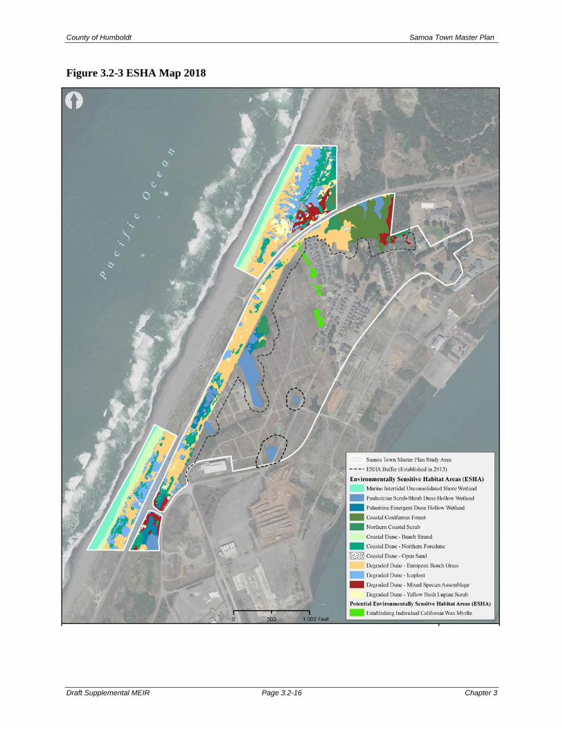
County of Humboldt Samoa Town Master Plan
Draft Supplemental MEIR Page 3.2-16 Chapter 3
Figure 3.2-3 ESHA Map 2018

County of Humboldt Samoa Town Master Plan
Draft Supplemental MEIR Page 3.2-17 Chapter 3
Additional, disjunct and discrete patches of California wax myrtle have also become established since previous investigations of the study area within that portion of European Beachgrass (Ammophila arenaria)-Dominated (Non-ESHA) degraded dune habitat, which occurs along the seaward slope between the existing residences accessed by Sunset Avenue and the log deck. The County’s current zoning and land use designation of this area is “Natural Resource”, despite not being designated as ESHA during prior analyses of the study area. Wax myrtle (Morella californica) is one of the most well represented species in the Northern Coastal Scrub ESHA vegetation type. It is an indicator of a potential wetland and intact vegetation communities are protected as ESHA. However, individual plants, such as those observed between the existing residences off of Sunset Avenue and the log deck to the west, have no explicit protective status. This area also has a County zoning designation of Natural Resource and is not currently planned for development. Given the recently established and disjunct distribution of individual plants in this specific portion of the study area previously determined (Dixon 2011) to be “non-ESHA” on the basis of its isolated position, “bounded by residential and other buildings, roadways, and urban vegetation and other development,” these discrete patches of California wax myrtle were not designated as ESHA in our recent effort. The vegetation under consideration here is, however, identified on Figure 3.2-3 as “potential ESHA” for purposes of identification and evaluation; however, no additional setback is proposed. Visitor Use/ Parking Improvement Areas West of New Navy Base Road One change to the Master Plan since the 2009 EIR are the proposed uses for the visitor use area west of New Navy Base Road near the Samoa Booster station and existing County parking/ beach access area. Instead of the previously proposed 15-tent camping spaces with picnic tables and fire pits; this area is proposed for day use only. Development associated with this visitor use area would include permanent interpretive displays, symbolic cord-and-post fencing, picnic tables and benches, and covered trash receptacles (Figure 3.2-4). The interpretive day use area would be sited in existing day use and degraded dune areas with far fewer impacts to habitat than the previously proposed tent camping area. In addition to this area, another site on the west side of New Navy Base Road across from LP Drive, known as Milwaukee Beach, was included in the Updated Biological Resources Study (2019). Proposed improvements to the existing parking area at this location include general aggregate paving, improved drainage swales, barriers, accessible parking space and signage (Figure 3.2-5). These areas are both designated Natural Resource and primarily consist of a mosaic of upland degraded and intact native Northern Foredune habitats. Botanical surveys were conducted in 2009 and 2018 at the location of the proposed visitor serving use area near the Samoa Booster Station. The botanical survey was completed to fulfill the requirements of 2009 MEIR Mitigation Measure 4.4.2h for the purposes of assessing potential impacts to known rare plant populations and EHSAs. Limited day use of this area would create less of a potential impact than the tent camping analyzed in the 2009 MEIR. Based on the 2018 survey in the vicinity of both visitor use area options, the mosaic of Northern Foredune and Degraded Dune ESHA remains, though vegetation community dynamics (e.g. establishment and development of invasive species, etc.) and abiotic dune processes transpiring since the most recent mapping of these areas have resulted in changes to the “internal” boundaries of the various types of ESHA within the encompassing aggregated coastal dune ESHA “perimeter”.

County of Humboldt Samoa Town Master Plan
Draft Supplemental MEIR Page 3.2-18 Chapter 3
Figure 3.2-4 Proposed Samoa Dunes Interpretive Area

County of Humboldt Samoa Town Master Plan
Draft Supplemental MEIR Page 3.2-19 Chapter 3
Figure 3.2-5 Proposed Milwaukee Beach Access Parking Improvements

County of Humboldt Samoa Town Master Plan
Draft Supplemental MEIR Page 3.2-20 Chapter 3
The increased visitors to the beach area due west of the Master Plan area associated with the proposed visitor serving uses could potentially intrude into non-wetland ESHAs in this area as described in the 2009 MEIR. As indicated in Figure 3.2-3, several non-wetland ESHAs occur in the vicinity of the proposed visitor serving use area, the proposed improvements to link the existing pedestrian tunnel under New Navy Base Road to the existing beach access corridor, and the existing beach access corridor itself. These include undeveloped dune ESHAs that support northern coastal scrub, native dune mat, European beachgrass, ice plant, yellow bush lupine, and open sand. Daily visitor activity associated with the proposed Master Plan could degrade these areas through persons and/or their dogs walking through the ESHAs. The increased visitors could also potentially degrade the open sand ESHA, but this would represent a less than significant impact given the small area of this ESHA to be impacted when measured against all the open sand ESHA on the Samoa peninsula, the lack of documented sensitive species in this ESHA in the vicinity of the Master Plan, and the fact that existing visitors already use the open sand ESHA to be impacted as an access corridor to the beach. Determination: Less than significant with incorporation of mitigation measures. Mitigation: The following mitigation measure are taken directly from the 2009 MEIR. Modifications to the original mitigation measures are identified in strikeout text to indicate deletions and underline to signify additions. 2009 MEIR Mitigation Measure 4.4.2a: Establish a well-marked trail system to consolidate high use areas and minimize foot traffic through Environmentally Sensitive Habitat Areas west of New Navy Base Road. Existing main routes to the beach shall be utilized to the greatest extent possible. An assessment will need to be conducted to determine the least environmentally damaging alternative to biological resources prior to designating a trail system west of New Navy Base Road. Once established, access points to all bike trails and foot paths throughout the plan area are to be clearly marked with appropriate regulatory, educational, and/or interpretive signage. Erect signage and/or fencing at designated access points (trail heads). 2009 MEIR Mitigation Measure 4.4.2b: Establish for the Master Plan area a sustainable landscaping plan designed to protect existing natural resources. Assistance for developing such a plan is available from a number of resources, including the Sustainable Urban Landscape Information Series (SULIS) and the Greenscape Program, funded by the U.S. EPA. 2009 MEIR Mitigation Measure 4.4.2c: Establish a well-marked trail system to consolidate high use areas and minimize foot traffic through ESHAs west of New Navy Base Road. The existing pedestrian beach access corridor shall remain the only beach access. No vehicles shall be allowed to access the beach through this corridor.

County of Humboldt Samoa Town Master Plan
Draft Supplemental MEIR Page 3.2-21 Chapter 3
2009 MEIR Mitigation Measure 4.4.2d: The 0.2 acres of European Beachgrass ESHA and 0.1 acres of native dune mat All ESHA to be displaced associated with the development of the 1.5-acre visitor serving use areas west of New Navy Base Road shall be replanted with native dune mat comparable habitat on a 3:1 basis. This replanting shall occur west of New Navy Base Road within the confines of the area covered by Figure 3.2-3 4.4-1, with the decision on the specific location within this area to be at the discretion of the California Coastal Commission. Seeds or other propagule material (divisions, cuttings, etc.) from the native flora within the existing native dune mat ESHA to be removed shall be collected in late spring (or as appropriate) and spread in the replanted habitat. Exotics shall be removed by hand within the replanted habitat until such time as the new native flora has established itself. 2009 MEIR Mitigation Measure 4.4.2e: An exotic plant removal program shall be implemented within the 1.5-acre visitor serving use area and associated new parking area west of New Navy Base Road to avoid the potential for the spread of exotic plant species into adjacent ESHAs. This program shall include the removal of exotics from said area on a monthly basis for the life of the Master Plan. 2009 MEIR Mitigation Measure 4.4.2f: ESHA protection fencing shall be installed at the locations set forth in Figure 4.4-1 3.2-4 to inhibit persons and dogs from entering existing ESHA areas in the vicinity of the proposed 1.5-acre visitor serving use area west of New Navy Base Road. The fencing shall be 3-foot tall split rail fencing or similar, such as cord and post, and shall be maintained on a monthly basis for the life of the Master Plan. 2009 MEIR Mitigation Measure 4.4.2g: All persons with dogs utilizing the beach areas due west of the Master Plan area shall maintain dogs on a leash in all areas of said beach (1.5-acre visitor serving use area, parking lots, day use area, beach access corridor, backdunes, foredunes), with the exception of the wave slope where dogs can be unleashed. 2009 MEIR Mitigation Measure 4.4.2h: A new botanical survey and site reconnaissance shall be undertaken in 2008 by a qualified biologist, and a new habitat map shall be prepared by the biologist which replaces Figure 4.4-1 (habitat map). The botanical survey shall be conducted during the following periods: March-April for wallflower and layia; March-July for beach layia; April-July for dark-eyed gilia; and June-October for pink sand-verbena. Figure 4.4.2 (fencing plan) shall be revised accordingly, but shall be no less stringent than it occurs in the MEIR. Mitigation Measures 4.4.2d and 4.4.2f shall be expanded to cover any additional ESHA area discovered during the 2008 survey/reconnaissance and shown on the revised habitat map, but shall be no less stringent. (Botanical Surveys for the STMP Coastal Access and Visitor Use Area were conducted in 2009 and 2018 to comply with mitigation measure 4.4.2h. Updated figures showing revised fencing plan and proposed parking are included as Figures 3.2-4 and 3.2-5 of this SMEIR.)
Impact 3.2.3: Impacts to Special-Status Species Discussion: The area proposed for development based on the tentative map is less than what was analyzed in the 2009 MEIR; therefore, potential impacts to special-status species will be similar to or less

County of Humboldt Samoa Town Master Plan
Draft Supplemental MEIR Page 3.2-22 Chapter 3
than those described in the 2009 MEIR. Potential impacts to special status animal species remain as described in the 2009 MEIR, with the updates described below. Three special status botanical species were encountered during the 2018 botanical surveys. These consisted of two State and Federally Endangered plants: Menzies' wallflower (Erysimum menziesii) and beach layia (Layia carnosa), as well as dark-eyed gilia (Gilia millefoliata), which has a CNPS “Rare Plant Rank” of 1B.2 [CNPS 2018a]) (Figure 3.2-1). State and Federally Endangered Menzies’ wallflower (Erysimum menziesii) was not previously reported to occur within the study area in any of the previous STMP-specific studies (Mad River Biologists 2004, 2009; Morrissette 2013). In 2018, multiple occurrences were encountered in native dune mat and degraded Northern Foredune habitats at both northern and southern extremities of the expanded study area, near areas being considered for visitor serving uses. All individuals at the northern end of the study area occupied dune ridges or slopes near the study area boundary north of New Navy Base Road. Similar geomorphic locations were observed for occurrences at the southern extremity of the study area as well, south of LP Drive. Because the Menzies' wallflower occurrences were located well outside areas proposed for development, and will be afforded at least 100-foot setbacks from development, no impacts to this species is anticipated. Botanical surveys were undertaken in 2013 and 2018 within that portion of the plan area subject to redevelopment east of New Navy Base Road. Historically-documented (Mad River Biologists 2004, 2009; Morrissette 2013) occurrences of the State and Federally Endangered beach layia (Layia carnosa) and dark-eyed gilia (Gilia millefoliata) were relocated on both sides of New Navy Base Road in 2018. Though the current extent of these occurrences varies slightly from previously reported distributions, inter-annual variation (such as was observed) is expected given the annual life history strategy of both species. Both species were also observed in the extensive linear degraded dune complex on the east side of New Navy Base Road as well, primarily in areas with exposed sand. However, dark-eyed gilia was also observed growing in small (~1-2 feet, radius) openings within the surrounding context of European beachgrass (Ammophila arenaria) within this region of the study area in multiple instances. A more extensive, linear occurrence of dark-eyed gilia also continues to persist in the exposed sand within the periodically disturbed HBMWD utility easement and contiguous remnant patches of native dune mat (Northern Foredune ESHA) as well. On the east side of New Navy Base Road, beach layia was restricted to a single discrete (~0.3 acre) patch of remnant native dune mat habitat, to the northwest of the Samoa Resource Recovery Center. Both the beach layia and the dark-eyed gilia occur within areas that have been designated as environmentally sensitive and afforded a 100-foot setback from proposed development. No impacts to these occurrences are anticipated from site development. Botanical surveys were conducted in 2009 and 2018 at the proposed visitor serving use location west of New Navy Base Road near the Samoa Booster station. The 2009 survey was completed to fulfill MEIR Mitigation Measure 4.4.2h requirements for assessing potential impacts to known rare plant populations and EHSAs. The 2018 survey was to provide updated special status species information and included the Milwaukee Beach access area. Menzies’ wallflower, beach layia, and dark-eyed gilia occur within the study area as shown in Figure 3.2-1. Beach layia and dark-eyed gilia were found in many of the same locations as they were in prior surveys but occupying smaller representative areas within the native dune mat community, on degraded dunes, and in areas of open sand. Menzies’ wallflower was found at both northern and southern

County of Humboldt Samoa Town Master Plan
Draft Supplemental MEIR Page 3.2-23 Chapter 3
extremities of the expanded study area, near areas being considered for visitor serving uses. in degraded northern foredune areas near beach layia and dark-eyed gilia. American Glehnia (Glehnia littoralis) was not relocated and none of the other target rare plant species were found. Increased use could potentially harass, degrade, and/or eliminate special-status animal and plant species from the visitor use areas. As indicated on Figure 3.2-1, beach layia and dark-eyed gilia occur near existing parking and day use areas. The proposed parking area and trail improvements will be designed to avoid these special status species as feasible, but have the potential to displace small occurrence areas. Special status wildlife species observed in the study area were primarily avian species. One observance was of the amphibian species northern red-legged frog (Rana aurora). This occurrence was outside of, but directly adjacent to (<175 feet), the eastern STMP area near the existing post office. Dune hollow wetlands could provide potential habitat. These areas are designated ESHAs with established setbacks and will not be impacted. Vegetated drainage ditches, impoundments, and similar features could also provide suitable northern red-legged frog habitat. Determination: Less than significant adverse impacts with incorporation of mitigation measures. Mitigation: The following mitigation measure are taken directly from the 2009 MEIR. Modifications to the original mitigation measures are identified in strikeout text to indicate deletions and underline to signify additions. Same as 2009 MEIR Mitigation Measure 4.4.2a. 2009 MEIR Mitigation Measure 4.4.3a: Prior to disturbance, a qualified biologist shall investigate all abandoned or vacant structures that are slated for demolition to determine whether they are in use by either Townsend’s big-eared bat, Hoary Bat, Long-eared Myotis, or pallid bat. If the structure(s) are not being used by either these species, plan activities can proceed with no further mitigation. If either any of these bat species isare determined to be using any of the abandoned structures, the applicant shall proceed with one of the following: Option 1: Cease demolition plans for the occupied building and maintain the structure(s) as bat
habitat. Option 2: Continue with demolition of the occupied building(s) and implement the following:
• Take measures to avoid injury or death of bats from demolition activities. This may involve relocating bats prior to the start of operations. A qualified biologist shall perform the relocation procedure.
• Create suitable habitat of a quality similar to or higher than that being destroyed elsewhere within the plan area and any bats disturbed during demolition must be re-introduced into the newly created habitat. A qualified biologist shall perform the relocation.

County of Humboldt Samoa Town Master Plan
Draft Supplemental MEIR Page 3.2-24 Chapter 3
2009 MEIR Mitigation Measure 4.4.3b: Prior to any blasting, pile driving, or any other such activity that elevates noise well above ambient levels, a qualified biologist shall be consulted to identify any potentially affected special status wildlife species (e.g. Osprey), and the biologist’s recommended mitigation measures shall be followed. 2009 MEIR Mitigation Measure 4.4.3c: The 0.2 acres of Any dark-eyed gilia and/or beach layia to be displaced associated with the development of the 1.5-acre visitor serving use areas west of New Navy Base Road shall be replanted in both area and number of plants on a 3:1 basis. This replanting shall occur west of New Navy Base Road within the confines of the area shown in Figure 3.2-34.4-1, with the decision on where within this area to be at the discretion of the California Coastal Commission. Seeds from the dark-eyed gilia and/or beach layia to be removed shall be collected in late spring or when appropriate and spread in the replanted habitat. Exotics shall be removed by hand within the replanted habitat until such time as the dark-eyed gilia and/or beach layia has established itself. 2009 MEIR Mitigation Measure 4.4.3d: Same as 2009 MEIR Mitigation Measure 4.4.2f (ESHA protection fencing). In addition, provide 3-foot tall split rail protection fencing around the following existing special-status species occurrences shown in Figure 4.4-1: (1) the dark-eyed gilia area immediately east of the proposed 1.5-acre visitor serving use area; and (2) the beach layia pockets west and south of the visitor serving area where not already to be fenced under Mitigation Measure 4.4.2f. (The proposed fencing is shown on Figure 3.2-4.) Same as 2009 MEIR Mitigation Measure 4.4.2g. 2009 MEIR Mitigation Measure 4.4.3e: A trash removal program shall be implemented in the area of the proposed 1.5-acre visitor serving use area west of New Navy Base Road, pedestrian beach access tunnel, beach access corridor, and 300 meters of the beach on either side of the beach access corridor. This program is designed to avoid the attraction of crows and ravens which could harass any Western Snowy Plovers which may nest in the area in the future. This program shall include trash removal from the area on a weekly basis for the life of the Master Plan. 2009 MEIR Mitigation Measure 4.4.3f: Mitigation Measure 4.4.2h requires that a new botanical survey and site reconnaissance be undertaken in 2008 by a qualified biologist, and that a new habitat map be prepared based on the findings. Mitigation Measures 4.4.3c and 4.4.3d shall be expanded to cover any additional special-status species area or new special status species discovered during the 2008 survey/site reconnaissance, but shall be no less stringent. (Botanical Survey for the STMP Coastal Access and Visitor Use Area was conducted in 2009 and 2018 to comply with mitigation measure 4.4.2h. Updated figures showing revised fencing plan and proposed parking are included as Figures 3.2-4 and 3.2-5 of this SMEIR.) Mitigation Measure 4.4.3g: Prior to commencement of construction activities within 100 feet of a wetland, an approved wildlife biologist will conduct a survey for the presence/absence of red-legged frog (Rana aurora) within planned construction areas. In the event that the species is found within planned construction areas, the occurrence will be reported and measures put in place to prevent the incidental take of any individuals including, but not limited to, placement of wildlife fencing and relocation of individuals by an approved biologist.

County of Humboldt Samoa Town Master Plan
Draft Supplemental MEIR Page 3.3-1 Chapter 3
3.3 GREENHOUSE GAS EMISSIONS Background & Introduction This Section of SMEIR evaluates the potential greenhouse gas (GHG) emissions generated by construction and operation of the Samoa Town Master Plan. At the time of MEIR certification, a quantitative evaluation of greenhouse gas emissions was not required under CEQA; and due to the still developing emissions thresholds and methodologies for greenhouse gas emissions analysis, potential impact analysis would have been speculative. Since MEIR certification, additional methods for analyzing greenhouse gas emissions have become available. In 2010, the CEQA Guidelines were amended to address the analysis and mitigation of the effects of greenhouse gas emissions. Because the 2009 MEIR did not address GHG emissions, these potential impacts are being evaluated in the SMEIR. This analysis is based on the Samoa Town Master Plan – Greenhouse Gas Emission Assessment, Prepared by Illingworth & Rodkin, January 16, 2014, which is included in SMEIR Appendix D. Environmental & Regulatory Setting Environmental Setting The project site is located within the North Coast Air Basin (NCAB), which includes all of Humboldt, Del Norte, Trinity, Mendocino Counties, and a portion of Sonoma County. The North Coast Unified Air Quality Management District (NCUAQMD) regulates air quality in the Humboldt, Del Norte and Trinity County portions of the NCAB, while Mendocino and Sonoma counties have separate air management districts. The climate of the region is dominated by a cold upwelling of seawater to the ocean surface off the Humboldt Coast. This cold ocean water cools the surface air. During the summer, winds flowing from the Pacific Ocean are drawn on shore by the difference in surface temperatures, resulting in daytime northwesterly winds. In winter, this temperature differential is less, and surface winds may blow from many directions depending on storm patterns. As a result of the region’s topography and coastal air movements, inversion conditions are common in the NCAB. Inversions are created when warm air traps cool air near the ground surface and prevents vertical dispersion of air. Valleys, geographic basins, and coastal areas surrounded by higher elevations are the most common locations for inversions to occur. During the summer, inversions are less prominent, and vertical dispersion of the air is good. However, during the cooler months between late fall and early spring, inversions last longer and are more geographically extensive; vertical dispersion is poor, and pollution may be trapped near the ground for several concurrent days.

County of Humboldt Samoa Town Master Plan
Draft Supplemental MEIR Page 3.3-2 Chapter 3
Greenhouse Gases and Climate Change Greenhouse gases are so called because of their role in trapping heat near the surface of the earth; they are implicated in global climate change, commonly referred to as “global warming.” These GHGs contribute to an increase in the temperature of the earth’s atmosphere by preventing the escape of heat in much the same way as glass in a greenhouse. These gases, mainly water vapor, carbon dioxide (CO2), methane (CH4), nitrous oxide (N2O), chlorofluorocarbons (CFCs), hydrofluorocarbons (HFCs), perfluorocarbons (PFCs), and sulfur hexafluoride (SF6), all act as effective global insulators, reflecting visible light and infrared radiation back to earth. These are released into the earth’s atmosphere through a variety of natural processes and human activities.
• Carbon dioxide and nitrous oxide are byproducts of fossil fuel combustion. • Nitrous oxide is associated with agricultural operations such as fertilization of crops. • Methane is commonly created by off-gassing from agricultural practices (e.g. keeping
livestock) and landfill operation. • Chlorofluorocarbons were widely used as refrigerants, propellants, and cleaning solvents
but their production has been stopped by international treaty. • Hydrofluorocarbons are now used as a substitute for chlorofluorocarbons in refrigeration
and cooling. • Perfluorocarbons and sulfur hexafluoride emissions are commonly created by industries
such as aluminum production and semi-conductor manufacturing. Each GHG has its own potency and effect upon the earth’s energy balance. This is expressed in terms of a global warming potential (GWP), with carbon dioxide being assigned a value of 1 and sulfur hexafluoride being several orders of magnitude stronger with a GWP of 23,900. In GHG emission inventories, the mass of each gas is multiplied by its GWP and is measured in units of carbon dioxide equivalent emissions (CO2e), and are often expressed in metric tons (MT CO2e) or millions of metric tons of CO2 equivalents (MMT CO2e). Human Influence and Potential Climate Change Impacts Climate change is not a local environmental impact; it is a global impact. Unlike criteria pollutants, CO2 emissions cannot be attributed to a direct health effect. Human activities, such as producing electricity and driving internal combustion vehicles, have contributed to the elevated concentration of GHG gases in the atmosphere. This in turn is causing the Earth’s temperature to rise. A warmer Earth may lead to changes in rainfall patterns, smaller polar ice caps, a rise in sea level, and a wide range of impacts on plants, wildlife, and humans. There is international scientific consensus that human-caused increases in GHGs have and will continue to contribute to global warming, although there is much uncertainty concerning the magnitude and rate of the warming and the extent of the impact on environmental systems. In 2009 the California Natural Resources Agency prepared a report to the Governor entitled "2009 California Climate Adaptation Strategy." The report details the expected impacts of global warming in California. These include:1
1 California Office of the Attorney General’s, Climate Impacts in California webpage: http://oag.ca.gov/environment/impact accessed December 11, 2013.

County of Humboldt Samoa Town Master Plan
Draft Supplemental MEIR Page 3.3-3 Chapter 3
• Seal level rise, coastal flooding, and coastal erosion; • Losses to the Sierra snowpack and water supply; • Forestry and higher risk of fires; • Damage to agriculture; • Increased demand for electricity; • Public health impacts; and • Habitat destruction and loss of ecosystems.
State and Regional GHG Emissions In 2008, California’s GHG emissions were approximately 478 MMT CO2e. 2 This large number is due primarily to the sheer size of California compared to other states. By contrast, California has one of the fourth lowest per-capita GHG emission rates in the country, due to the success of its energy-efficiency and renewable energy programs and commitments that have lowered the state’s GHG emissions rate of growth by more than half of what it would have been otherwise. Transportation is the source of approximately 37 percent of the state’s GHG emissions, followed by electricity generation (both in-state and out-of-state) at 24 percent, and industrial sources at 19 percent. Residential and commercial sources account for 9 percent, while agriculture, waste, high GWP compounds, and forestry account for 5.9, 3.3, 1.4, and 0.04 percent, respectively.3 A GHG inventory developed for unincorporated Humboldt County as part of the County’s General Plan Update included 1990 and 2006 GHG emissions. In terms of overall GHG emissions, the County has seen a significant decline in industrial emissions since 1990. This may be attributed to a steady and significant decline in the lumber industry and closure of major industrial facilities related to timber processing, including numerous lumber mills and several pulp mills. The 2006 overall GHG emissions in unincorporated Humboldt County was 1.3 MMT CO2e; approximately a half a million metric tons less than 1990 CO2e.4 Regulatory Setting Global climate change is addressed through the efforts of various federal, state, regional, and local government agencies as well as national and international scientific and governmental conventions and programs. These agencies work jointly and individually to understand and regulate the effects of greenhouse gas emissions and resulting climate change through legislation, regulations, planning, policymaking, education, and a variety of programs. The national, state, and regional programs focused GHG emissions are discussed below. GHG Regulation on a National Level On April 2, 2007, the United States Supreme Court ruled that the U.S. Environmental Protection Agency (EPA) has the authority to regulate carbon dioxide (CO2) emissions under the Federal Clean Air Act. After a thorough examination of the scientific evidence and careful consideration of public comments, the EPA announced on December 7, 2009, that GHG emissions threaten the 2 California Air Resources Board, Greenhouse Gas Inventory Data 2002-2008. 3 Ibid. 4 Humboldt County General Plan Update Draft EIR, Chapter 3.12, Air Quality and Greenhouse Gas Emissions, April 2, 2012.

County of Humboldt Samoa Town Master Plan
Draft Supplemental MEIR Page 3.3-4 Chapter 3
public health and welfare of the American people. The findings do not in and of themselves impose any emission reduction requirements, but do allow the EPA to finalize the GHG standards proposed in 2009 for new light-duty vehicles as part of the joint rulemaking with the Department of Transportation. The EPA’s endangerment finding covers emissions of six key greenhouse gases—carbon dioxide (CO2), methane (CH4), nitrous oxide (N2O), hydrofluorocarbons (HFCs), perfluorocarbons (PFCs), and sulfur hexafluoride (SF6)—that have been the subject of scrutiny and intense analysis for decades by scientists in the United States and around the world. GHG Regulation on a State Level Assembly Bill 32 (AB 32), the Global Warming Solutions Act, was passed by the California state legislature on August 31, 2006, to place the state on a course toward reducing its contribution of GHG emissions. The Bill required the California Air Resources Board (CARB) to develop and enforce regulations for the reporting and verifying of statewide GHG emission. AB 32 requires the state’s global warming emissions to be reduced to 1990 levels by the year 2020 and the adoption of rules and regulations to achieve the maximum technologically feasible and cost-effective GHG emissions reductions. Based on CARB’s calculation of 1990 baseline emissions levels, California must reduce GHG emissions by approximately 28.5 percent below “business-as-usual” predictions of year 2020 GHG emissions to achieve this goal. In July 2011 CARB revised its “business as usual” GHG emission estimate for 2020, in order to account for the recent economic downturn in its emission projections.5 The estimate presented in the scoping plan (596 MMT CO2e) was based on pre-recession, 2007 data from the Integrated Energy Policy Report. CARB has updated the projected “business as usual” 2020 GHG emissions to 545 MMT CO2e. AB 32 also requires CARB to prepare a Scoping Plan to achieve GHG reductions in California. In June 2008, CARB released a draft of the Climate Change Scoping Plan, which was revised in October 2008. The final Scoping Plan was adopted by CARB on December 11, 2008. Key elements of CARB’s Scoping Plan are:
• Expanding and strengthening existing energy efficiency programs as well as building and appliance standards;
• Increases the State’s Renewable Portfolio Standard (RPS) to 33 percent by 2020. Retail sellers of electricity are required to increase the portion of electricity they provide each year by renewable energy to achieve the 33 percent goal;
• Developing a California cap-and-trade program that links with other Western Climate Initiative partner programs to create a regional market system for large stationary sources;
• Establishing targets for transportation-related GHG emissions for regions throughout California, and pursuing policies and incentives to achieve those targets;
5 California Air Resources Board, Status of Scoping Plan Recommended Measures (July 2011).

County of Humboldt Samoa Town Master Plan
Draft Supplemental MEIR Page 3.3-5 Chapter 3
• Adopting and implementing measures pursuant to state laws and policies, including California’s clean car standards, goods movement measures, Low Carbon Fuel Standard; and
• Creating target fees, including a public goods charge on water use, fees on high global warming potential gases, and a fee to fund the administrative costs of the state’s long-term commitment to AB 32 implementation.
In addition to the requirements under AB 32 to address GHG emissions and global climate change in general plans and CEQA documents, Senate Bill 97 (Chapter 185, 2007) required the Governor’s Office of Planning and Research (OPR) to develop CEQA guidelines for addressing global warming emissions and mitigating project-generated GHG emissions. OPR transmitted the proposed guidelines to CNRA and the guidelines were adopted on December 30, 2009. The amended CEQA Guidelines became effective on March 18, 2010. The new CEQA Guidelines concerning GHG emissions do not include or recommend any particular threshold of significance; instead, they leave that decision to the discretion of the lead agency. However, with respect to adopting thresholds of significance, newly added CEQA Guidelines section 15064.7(c) provides:[A] lead agency may consider thresholds of significance previously adopted or recommended by other public agencies or recommended by experts, provided the decision of the lead agency to adopt such thresholds is supported by substantial evidence. The new CEQA Guidelines also do not suggest or recommend the use of any specific GHG emission mitigation measures. Instead, CEQA Guidelines section 15126.4(c) provides that lead agencies shall consider feasible means, supported by substantial evidence and subject to monitoring or reporting, of mitigating the significant effects of greenhouse gas emissions. Among other things, CNRA noted in its public notice for these changes to the CEQA Guidelines that the impacts of GHG emissions should be considered in the context of a cumulative impact, rather than a project impact. The public notice states:
While the Proposed Amendments do not foreclose the possibility that a single project may result in greenhouse gas emissions with a direct impact on the environment, the evidence before [CNRA] indicates that in most cases, the impact will be cumulative. Therefore, the Proposed Amendments emphasize that the analysis of greenhouse gas emissions should center on whether a project’s incremental contribution of greenhouse gas emissions is cumulatively considerable.
GHG Regulation on a Regional Level Policies, regulations and plans for GHG reduction in the NCUAQMD are either recently adopted or in draft form including:
• Humboldt County General Plan Update, adopted October 23, 2017. The Humboldt County General Plan contains numerous policies and programs aimed at reducing GHG emissions. The Air Quality Element also recognizes the County has significant resources for carbon sequestration on timber and agricultural lands. It specifies a successful mitigation of GHG emissions as Reducing emissions to levels of “non-significance” as established by AB 32 and subsequent legislation.

County of Humboldt Samoa Town Master Plan
Draft Supplemental MEIR Page 3.3-6 Chapter 3
• NCUAQMD’s Proposed Revisions to Regulation I, Rule 111. These revisions address emissions of 6 GHGs (carbon dioxide, methane, nitrous oxide, hydrofluorocarbons, perfluorocarbons, and sulfur hexafluoride), and define levels of significance for GHG emissions (in tons per year, CO2 equivalents). However, these regulations only apply to stationary sources.
The following policy was added to the Humboldt Bay Area Plan, per the California Coastal Commission, as part of the STMP General Plan (Local Coastal Plan) Amendment approval.
STMP (New Development) Policy 7: A. To minimize energy demands, which are associated with structural and transportation
energy use, development of lands subject to the STMP-LUP shall minimize vehicle miles traveled, and conserve energy by means such as, but not limited to, the following: 1. Siting development in a manner that will minimize traffic trips; 2. Prohibiting retail sales establishments designed to attract more than an incidental
percentage of customers from offsite areas; 3. Incorporating the “smart growth” development concepts that combine
interdependent uses that potentially reduce offsite traffic trips, including adequate grocery and convenience stores in the revitalized downtown area to supply resident and visitor needs with fewer offsite trips;
4. Providing well designed and appropriately located bus stops along Vance Avenue; 5. Providing amenities for the convenience and safety of pedestrians and bicyclists to
encourage the use of non-motorized and/or public transportation, including a well-designed network of bicycle paths, safe sidewalks, and separate footpaths that link various areas within Samoa and to the nearby beach and natural resource area interpretive trails;
6. Incorporating energy efficient building technologies; 7. Requiring development to meet high standards regarding the energy efficiency of
proposed structures; heating, ventilation, and air conditioning systems (HVAC); hot water heaters, appliances; insulation; windows; doors; and lighting such as the established voluntary Energy Star, LEED, or Build It Green standards;
8. Requiring development to incorporate alternative sources of energy such as photovoltaics, solar water heaters, passive solar design, wind generators, heat pumps, geothermal, or biomass;
9. Requiring development to use structural orientation (heat gain from southern exposure) and vegetation patterns to reduce winter heating needs (such as planting deciduous trees near southern exposures to maximize the winter sun);
10. Requiring development to include energy meters that provide real-time information to users regarding energy consumption;
11. Requiring development to use recycled building materials; 12. Requiring development to use building materials that minimize energy
consumption during the manufacture and shipment of the materials; 13. Requiring development to use construction techniques that minimize energy
consumption;

County of Humboldt Samoa Town Master Plan
Draft Supplemental MEIR Page 3.3-7 Chapter 3
14. Incorporating non-residential development amenities to encourage non-motorized or public transportation use by employees (such as sheltered bicycle storage, bicycle lockers, restrooms with showers/personal lockers, etc.);
15. Encouraging employer incentives such as paid bus passes, etc., to encourage employee use of public transportation;
16. Prohibiting restrictions such as covenants or development standards that prevent energy conserving measures such as the use of outdoor clotheslines.
B. Coastal Development Permits authorized for development of lands subject to the
STMP-LUP shall include specific findings concerning the extent of the subject project’s incorporation of measures to reduce vehicle miles traveled and to minimize the use of energy.
Impacts & Mitigation Measures
Evaluation Criteria For evaluating the potential greenhouse gas emission impacts of the proposed Master Plan, implementation of the project may have a significant adverse impact on global climate change if it would do any of the following: • Generate greenhouse gas emissions, either directly or indirectly, that may have a significant
impact on the environment.
• Conflict with an applicable plan, policy, or regulation adopted for the purpose of reducing the emissions of greenhouse gases.
Impact 3.3.1: Generate greenhouse gas emissions
Discussion: Global climate change is not confined to a particular project area and is generally accepted as the consequence of global industrialization over the last 200 years. A typical project, even a very large one, does not generate enough GHG emissions on its own to influence global climate change significantly; hence, the issue of global climate change is, by definition, a cumulative environmental impact. The analysis below provides the conclusions on the project specific impact toward the cumulative impact of global climate change. Construction and operation of project development would generate GHG emissions. GHG emissions were computed for the full build out scenario of the Samoa Town Master Plan. Specifically, construction emissions were computed for an assumed 5-year construction period with operational emissions in 2020. The California Emissions Estimator Model Version 2013.2.2 (CalEEMod) was used to predict GHG emissions from construction and operation of the project. The model predicts emissions of GHGs in the form of equivalent CO2 emissions (CO2e). In order to obtain the CO2e, an individual GHG is multiplied by its global warming potential. The methodology and assumptions used in this analysis are summarized below for

County of Humboldt Samoa Town Master Plan
Draft Supplemental MEIR Page 3.3-8 Chapter 3
construction and operation activities. Refer to Appendix D (Greenhouse Gas Emission Assessment) for model output and detailed calculations. The land use types and sizes, trip generation rates and other plan-specific information available were input to the model. The use of this model for evaluating emissions from land use projects is recommended by the California Association of Air Pollution Control Officers (CAPCOA) and air districts in California. Unless otherwise noted, the CalEEMod model defaults for Humboldt County were used. CalEEMod provides emissions for transportation, areas sources, electricity consumption, natural gas combustion, electricity usage associated with water usage and wastewater discharge, and solid waste land filling and transport. Construction Emissions During construction of the project GHGs would be emitted through the operation of construction equipment and from worker and vendor vehicles, each of which typically uses fossil fuels to operate. The combustion of fossil fuels generates GHGs such as CO2, CH4, and N2O; CH4 is also emitted during the fueling of heavy equipment. Construction is a temporary source of emissions necessary to facilitate development of the project. Operational Emissions The following activities are typically associated with the operation of residential and commercial land uses that will contribute to the generation of GHG emissions.
Motor Vehicle Use – Vehicle trips generated by the project would result in GHG emissions through combustion of fossil fuels. Master Plan trip generation rates were entered into CalEEMod for each land use. Gas and Electricity Use – Natural gas use results in the emissions of two GHGs: CH4 (the major component of natural gas) and CO2 from the combustion of natural gas. Electricity use can result in GHG production if the electricity is generated by combusting fossil fuel. Water Use - California’s water conveyance system is energy-intensive, with electricity used to pump and treat water. The project would contribute indirectly to emissions by consuming water. Solid Waste Disposal – Disposal of organic waste in landfills can lead to the generation of methane, a potent greenhouse gas. By generating solid wastes, the project would contribute to the emission of fugitive methane from landfills, as well as CO2, CH4 and N2O from transporting and managing the waste.
Table 3.3.1 presents the results of the CalEEMod model analysis in terms of annual metric tons of equivalent CO2 emissions (MT of CO2e/yr) by source category. The CalEEMod modeling data are provided in Appendix D.

County of Humboldt Samoa Town Master Plan
Draft Supplemental MEIR Page 3.3-9 Chapter 3
Table 3.3.1 Samoa Town Master Plan GHG Emissions
Source Category Samoa Town Master Plan in 2020 (MT of CO2e/yr)
Construction (2015-2019) 7,924 total 1,584 per year
Operational per year Area 424
Energy 1,565 Mobile 4,465
Solid Waste 231 Water 202
Total 7,086 The project’s incremental increases in GHG emissions associated with construction, increased energy demand, and traffic increases would contribute to regional and global increases in GHG emissions and associated climate change effects. Project construction would generate approximately 8,000 MT CO2e and project operation would generate approximately 7,100 Metric Tons (MT) CO2e annually. The 2014 GHG inventory report developed for unincorporated Humboldt County as part of the County’s General Plan Update stated overall GHG emissions as approximately 1.15 Million Metric Tons (MMT) CO2e.6 Based on the County’s 2006 GHG emissions, project operation would increase the overall County emissions by approximately 0.6% annually (not including construction). There are no adopted quantitative thresholds of significance for GHG emissions in Humboldt County. Master Plan development would incorporate the measures outlined in STMP (New Development) Policy 7, described under the Regulatory Environment section above, related to minimizing vehicle miles traveled and energy demand. The Humboldt County General Plan Update EIR GHG Emissions Section concludes that:
“Given the scope of global climate change, it is not anticipated that a single development project, even one of the relatively large scale ….. would have an individually discernable effect on global climate change.”
Therefore, the Master Plan project would have a less than significant impact related to GHG emissions. Determination: Less than significant impact. Mitigation: No mitigation necessary.
6 Humboldt County General Plan Update EIR, Chapter 3.13, Climate Change and Greenhouse Gas Emissions, adopted September 25, 2017.

County of Humboldt Samoa Town Master Plan
Draft Supplemental MEIR Page 3.3-10 Chapter 3
Impact 3.3.2: Conflict with applicable plans Discussion: The Humboldt County General Plan Update contains numerous policies and programs aimed at reducing GHG emissions in the unincorporated County and responding to the potential effects of climate change. The Master Plan is consistent with the County General Plan draft policies that address GHG reduction strategies including, but not limited to: providing mixed-use, compact development, providing transit, bicycle and pedestrian facilities, maintaining natural and landscape buffers, and developing a neighborhood center. Master Plan development would also incorporate the measures outlined in STMP (New Development) Policy 7, described under the Regulatory Environment section above, related to minimizing vehicle miles traveled and energy demand. The project would not conflict with the goals identified in AB 32, the County General Plan, or the County’s Draft Climate Action Plan and is consistent with the approved Humboldt Bay Area Plan Amendments. Determination: Less than significant impact. Mitigation: No mitigation necessary. References Humboldt County General Plan Update EIR, Chapter 3.13, Climate Change and Greenhouse Gas Emissions, Adopted September 25, 2017.

County of Humboldt Samoa Town Master Plan
Draft Supplemental MEIR Page 3.4-1 Chapter 3
3.4 TRANSPORTATION Background & Introduction This section of the SMEIR provides a transportation analysis update of transportation and traffic impacts based on tentative map land uses. This update includes Samoa Town Master Plan trip generation volume estimates comparing the level of development analyzed in the 2009 MEIR to that resulting from the tentative map. This SMEIR analysis is limited to vehicle trips. The analysis of other potential transportation impacts including increased bicycle and pedestrian trips, increased transit demand and increased parking demand in the 2009 MEIR remains valid. Additionally, this section incorporates relevant information from the Samoa Industrial Waterfront Preliminary Transportation Access Plan (SIWPTAP) prepared for the Humboldt Bay Harbor, Recreation, and Conservation District (LACO Associates, December 2013). The SIWPTAP included a traffic analysis memorandum prepared by Whitlock & Weinberger Transportation, Inc. (w-trans) dated July 19, 2013; included as Appendix E to this SMEIR. This memo describes potential traffic impacts generated by development in the Samoa industrial waterfront area, including the Samoa Town Master Plan. Environmental/ Regulatory Setting Environmental Setting Section 2.2 of the 2009 MEIR, incorporated by reference here, describes the transportation overview of the project area including roadway, bicycle, pedestrian, and transit facilities. The operational characteristics of the existing Samoa area circulation system remains as described in the 2009 MEIR and is summarized below. The town of Samoa is located approximately 3.5 miles north of the City of Eureka, and 7 miles east of Arcata. All traffic into and out of Samoa travels via New Navy Base Road, which serves as the primary arterial on the Samoa Peninsula. From Eureka, the Samoa Bridge provides access to New Navy Base Road, which is designated as State Route (S.R.) 255 between the bridge and the City of Arcata. S.R. 255 passes through the town of Manila and provides access over the Mad River Slough into the City of Arcata where it transitions from a 2-lane highway to a city arterial and provides access to the U.S. 101 ramps in Arcata. (U.S. 101 runs north/south through Eureka and Arcata.) It should be noted that S.R. 255 is also referred to as New Navy Base Road in the Manila area, Samoa Boulevard in the City of Arcata, and R Street in portions of Eureka. The primary access to the town of Samoa off of New Navy Base Road are Vance Avenue, Cookhouse Road, and Samoa Pulp Lane (formerly LP Drive). Vance Avenue intersects New Navy Base Road to the north of the Samoa Bridge and runs parallel to New Navy Base Road and forms the town’s main street. New Navy Base Road runs the length of the peninsula from the Samoa Bridge to the Humboldt Bay Coast Guard station at the southern end of the peninsula. Cookhouse Road is the primary access point for Samoa traffic and is located just southwest of

County of Humboldt Samoa Town Master Plan
Draft Supplemental MEIR Page 3.4-2 Chapter 3
the S.R. 255/New Navy Base Road intersection. Samoa Pulp Lane intersects New Navy Base Road to the southwest of the town and provides access to Vance Avenue. New Navy Base Road is a two-lane conventional highway with occasional passing permitted. For most cross streets, there are left and right turn pockets available. At Samoa Pulp Lane, the northbound section of the road becomes two lanes for a short distance. The posted speed limit on New Navy Base Road is 55 miles per hour. Other streets in the town of Samoa include Fenwick Avenue, a narrow residential street that intersects Vance Avenue. Rideout Road is a main cross street with Vance Avenue, and it provides access in both directions to residential neighborhoods and the Samoa Hostelry. The Samoa Block and the Post Office are along Cutten Street. The 2009 MEIR describes existing conditions including an assessment of the streets and intersections located at the interface of Samoa and the adjacent highway system as well as intersections with Arcata and Eureka. These descriptions remain valid except improvements have been constructed at: the SR 255/3rd Street and SR 255/5th Street intersections in the City of Eureka, along Samoa Blvd. in the City of Arcata, and on SR 255 through Manila. The July 19, 2013 w-trans traffic impact analysis memorandum (Appendix E) includes a traffic evaluation and assessment of five key intersections:
• New Navy Base Road/ Samoa Pulp Lane (formerly LP Drive) • New Navy Base Road/ Cookhouse Road • New Navy Base Road/ SR 255 • SR 255/ 4th Street (City of Eureka) • SR 255/ 5th Street (City of Eureka)
Existing traffic volumes for these intersections were factored forward to reflect 2013 conditions. The growth factor was based on Caltrans District 1 20-year growth factors. These resulting traffic volumes are shown in Figure 3.4-1. Peak hour intersection Level of Service (LOS) conditions were calculated for: existing, future (2033) without project, existing with STMP, existing with STPM and industrial waterfront development, future with STMP, and future with STMP and industrial waterfront development. All five intersections listed above are currently operating acceptably at LOS C or better (Table 3.4.2).

County of Humboldt Samoa Town Master Plan
Draft Supplemental MEIR Page 3.4-3 Chapter 3
Figure 3.4-1 Traffic Volumes (2013) Regulatory Setting The applicable plans, policies, codes and regulations remain as described in the 2009 MEIR. The following applicable policies were added to the Humboldt Bay Area Plan, per the California Coastal Commission, as part of the STMP General Plan (Local Coastal Plan) Amendment approval.
STMP (New Development) Policy 7: (Only relevant excerpts of the policy are provided below, see HBAP for complete policy language)
A. To minimize energy demands, which are associated with structural and transportation energy use, development of lands subject to the STMP-LUP shall minimize vehicle miles traveled, and conserve energy by means such as, but not limited to, the following: 1. Siting development in a manner that will minimize traffic trips; and 2. Prohibiting retail sales establishments designed to attract more than an incidental
percentage of customers from offsite areas; 3. Incorporating the “smart growth” development concepts that combine interdependent uses that potentially reduce

County of Humboldt Samoa Town Master Plan
Draft Supplemental MEIR Page 3.4-4 Chapter 3
offsite traffic trips, including adequate grocery and convenience stores in the revitalized downtown area to supply resident and visitor needs with fewer offsite trips; and
3. Providing well designed and appropriately located bus stops along Vance Avenue; and
4. Providing amenities for the convenience and safety of pedestrians and bicyclists to encourage the use of non-motorized and/or public transportation, including a well-designed network of bicycle paths, safe sidewalks, and separate footpaths that link various areas within Samoa and to the nearby beach and natural resource area interpretive trails; and…
B. Coastal Development Permits authorized for development of lands subject to the STMP-LUP shall include specific findings concerning the extent of the subject project’s incorporation of measures to reduce vehicle miles traveled and to minimize the use of energy.
STMP (Coastal Access) Policy 2:
A. All approved pedestrian and bicycle paths, corridors, trails and tsunami evacuation routes within the lands subject to the STMP-LUP shall be open to the public at all times. These routes shall not be blocked, gated, obscured, or otherwise barricaded at any time except as may be necessary for initial construction and for occasional short-term maintenance. All approved public park and open space and pedestrian/bikeway paths and related amenities shall be completed and the facilities opened to the public prior to the commencement of development within either the Business Park area or the new residential areas.
B. Prior to the issuance of the coastal development permit for the comprehensive division of Master Parcel 2, the location of pedestrian and bicycle routes subject to this policy shall be surveyed and mapped and a deed restriction protecting the routes against conversion to another use shall be recorded. In addition, prior to the issuance of the coastal development permit for the comprehensive division of Master Parcel 2, a dedication or offer of dedication in perpetuity of a public access easement to a public agency or qualified non-profit organization shall be recorded for all existing or proposed pedestrian or bicycle routes, including routes prescribed elsewhere in these policies for coastal access and recreational purposes. The dedication or offer of dedication shall not contain a “sunset” provision and shall remain valid in perpetuity until or unless accepted by a qualified party.
C. A map of the subject bicycle and pedestrian pathway/trail system shall be developed and posted at publicly visible central locations within the STMP-LUP area, including at the main entrance to the Samoa Cookhouse area.
STMP (Coastal Access) Policy 4:
A. At least two (2) bus stops shall be constructed within the Town of Samoa in accordance with the following requirements:

County of Humboldt Samoa Town Master Plan
Draft Supplemental MEIR Page 3.4-5 Chapter 3
1. The bus stop locations must allow the Humboldt Transit Authority (or successor provider of public transportation services) buses sufficient area to enter, pull over completely out of adjacent through-traffic, and exit the turnout in accordance with physical limits and safety requirement. The necessary turnout area shall be approximately 100 feet in length and proportioned to allow for maneuvering of a 40-ft-long, 102-inch wide bus. Evidence that final designs for the bus stops have been reviewed and approved by the Humboldt Transit Authority shall be required prior to approval of a coastal development permit for the comprehensive division of Master Parcel 2; and
2. The bus stop waiting areas shall be covered and weather-sheltered, well lighted for personal security, and furnished with maintained trash receptacles that are wildlife impermeable.
B. The bus stops required herein shall be installed prior to commencement of construction of development within the new residential and business park areas.
C. In accepting Commission certification of LCP Amendment Request HUM-MAJ-01-08, the County agrees to request that Humboldt Transit Authority add regularly scheduled bus service of the STMP-LUP lands upon approval of coastal development permits for development within the business park and new residential areas.
Impacts & Mitigation Measures
Impact 3.4.1: Increased Vehicle Trips Discussion: The overall scope of the Master Plan project has been reduced from what was analyzed in the 2009 MEIR in terms of total acres of proposed development, number of proposed new residential units, and business park acreage. Generally, the area of land designated for development is less than what was proposed in the MEIR and the area designated Natural Resources has increased. Table 3.4.1 compares 2009 MEIR trip generation projections with tentative map estimated trips. Based on the tentative map, the Samoa Town Master Plan is expected to result in an average of 4,308 new weekday vehicle trips, which is approximately 60% of the 7,239 trips analyzed in the 2009 MEIR. This decrease in mainly due to reduced business park acreage and waterfront industrial buildout projections of 10% as described in the Samoa Industrial Waterfront Preliminary Transportation Access Plan. Development of only 10% of the unused industrial land is estimated due to extensive industrial land supply on the Samoa Peninsula. In addition, no CDI uses are planned for in the Samoa Town Master Plan. The following is a comparison of tentative map and Master Plan transportation related impacts.
• The tentative map would be expected to generate lower daily traffic volumes compared with Master Plan analyzed in the 2009 MEIR;
• The tentative map would be expected to generate lower peak hour traffic volumes compared to the Master Plan analyzed in the 2009 MEIR;

County of Humboldt Samoa Town Master Plan
Draft Supplemental MEIR Page 3.4-6 Chapter 3
• There would be increased seasonal travel due to the introduction of visitor use areas both east and west of New Navy Base Road; and
• Improved day use facilities and additional parking west of New Navy Base Road, would increase travel in and out of the existing parking lot.
The following intersection analysis is based on the July 19, 2013 w-trans memo which reflected buildout conditions based on the 2009 MEIR; therefore actual peak hour vehicle trips are expected to be lower than these projections. The LOS calculations are summarized below and in Table 3.4.2. Under future conditions with general background growth and without Samoa Town Master Plan development, the majority of the intersections would operate acceptable at LOS C or better, with the exception of:
• SR 255/New Navy Base Road is expected to deteriorate to LOS D under PM peak hour conditions.
Under existing conditions with development of the Samoa Town master Plan, the majority of the intersections would continue to operate acceptably at LOS C or better, with the exception of:
• SR 255/New Navy Base Road is expected to deteriorate to LOS E under PM peak hour conditions.
Under future conditions with development of the Samoa Town Master Plan, the majority of the intersections would continue to operate acceptably at LOS C or better, with the exception of:
• SR 255/New Navy Base Road is expected to deteriorate to LOS F under PM peak hour conditions.
• SR 255/ 4th Street is expected to deteriorate to LOS D under PM peak hour conditions. Cumulative impacts resulting from the Master Plan and adjacent industrial waterfront development could result in unacceptable conditions at the New Navy Base Road/ Cookhouse Drive intersection (W-trans Memo, July, 19 2013, Appendix E). However, as shown in Table 3.4.2 below, future conditions plus the Master Plan would result in LOS B.

County of Humboldt Samoa Town Master Plan
Admin. Draft Supplemental MEIR Page 3.4-7 Chapter 3
Table 3.4.1 Samoa Town Master Plan and Tentative Map Trip Generation Projections Number of Units
Units Land Use Type Trip Rate per Unit
Percent Change (from 2007 to 2019)
Weekday Total External Trips2
2007 Master Plan1
2019 Tent. Map 2007 2019
33.5 35 acres General Light Industrial (CDI) 10 percent internal capture Reduction based on buildout projections5
51.8
51.8
4.5% increase
10% of area
1,562
163
2473 1983 units Single Family Detached Housing 25 percent internal capture 9.57 23% decrease 1,773 1,421
46 80 units Apartment (Multi-family units per TM) 25 percent internal capture 6.72 74% increase 232 404
1 0 arena Soccer Complex – indoor (not in TM) 90 percent internal capture 71.33 100% decrease 7 0
1 3 ksf Museum (Library rates) next to Cookhouse – 5 percent internal capture 54 300% increase 51 154
4 4 fueling posts
Gasoline Service Station w/ conv. store 75 percent internal capture 162.78 0% 163 163
18.7 8.4 acres Business park 10 percent internal capture 149.79 55% decrease 2,521 1,470
23 23 ksf Specialty retail (Samoa Block) 75 percent internal capture 44.32 0% 255 255
0.6 0.6 acres Mini-warehouse 25 percent internal capture 38.87 0% 17 17
30 35 sites 20 cabin and 15 tent camping sites 10 percent internal capture 5.29 17% increase 143 166
22 04 rooms Cadman Court (vacation rentals) 10 percent internal capture 8.17 100% decrease 162 0
48 30 rooms Hotel (total rooms) for hostel above Cookhouse – 10 percent internal capture 8.17 37.5% decrease 353 221
Net New External Trips 7,239 4,434
2019 Trip Generation compared to 2007 61%

County of Humboldt Samoa Town Master Plan
Admin. Draft Supplemental MEIR Page 3.4-8 Chapter 3
1 - Based on Samoa Town Master Plan DMEIR Table 4.2-3 Trip Generation 2 - Does not include internal trips projected to stay within the Town of Samoa 3 - Does not include existing single family residential (99 units) or existing trips from other uses 4 - No new units proposed; conversion of existing residential units 5 - Based on the Samoa Industrial Waterfront Transportation Access Plan by the Harbor District- CDI uses near
docks projected buildout at 10% of available land area. This is due to extensive industrial land supply on Samoa Peninsula. In addition, no CDI uses are planned for in the Samoa Town Master Plan.
Table 3.4.2 Peak Hour Intersection Levels of Service
Notes: Delay is measured in average seconds per vehicle; LOS = Level of Service; Results for minor approaches to two-way stop
controlled intersections are indicated in italics; ** = delay greater than 120 seconds; Shaded cells = conditions with recommended improvements.
Source: Excerpt from W-trans memo, Samoa Industrial Waterfront Transportation Access Plan Table 2, July 19, 2013 (Appendix E).
Determination: Less than significant adverse impact with incorporation of mitigation measures. Mitigation: The following mitigation measures are taken directly from the 2009 MEIR. Modifications to the original mitigation measures are identified in strikeout text to indicate deletions and underline to signify additions. 2009 MEIR Mitigation Measure 4.2.1a: S.R. 255/3rd Street: Improvements include installation of medians to allow only right-turn movements in and out of 3rd Street or future traffic signal. The proposed Master Plan shall be responsible for contributing a fair share amount towards the mitigation approach worked out with the City of Eureka and Caltrans at some point in the future. The suggested fair share amount is a plan contribution of 33 percent, which was calculated based

County of Humboldt Samoa Town Master Plan
Admin. Draft Supplemental MEIR Page 3.4-9 Chapter 3
on the critical p.m. peak hour volume of 518 vehicles generated by the Master Plan, divided by the total future volume including the Plan development (1,573 vehicles). Assuming a traffic signal, the fair share would be $66,000 ($200,000 x 33%). If the City determines that turn lanes shall be added to the intersection, rather than a signal, then the amount would be reduced proportional to the cost. The fair share mitigation contribution shall be provided at the time that the impact is expected to occur. Based on the analysis, the impact is expected to occur (threshold of LOS E/F) after 20 percent of the development is occupied, or approximately 160 residential units. It is suggested that the County arrange for payment of the mitigation fee in Phase 2. (The SR 255/3rd Street improvements were completed by Caltrans and the City of Eureka in 2012. Medians were installed to allow only right turn movements in and out of 3rd Street. No additional mitigation is required.) 2009 MEIR Mitigation Measure 4.2.1b: S.R. 255 through Manila: Improvements to be determined by Phase II of Manila Transportation Plan. The Master Plan shall contribute its fair share towards these improvements. The suggested fair share amount is a plan contribution of 22.5 percent, which was calculated based on the critical p.m. peak hour volume of 258 vehicles generated by the Master Plan, divided by the total future volume including the Plan development (1,147 vehicles). It is likely that S.R. 255 improvements consisting of left-turn lanes and a traffic signal or roundabout will cost approximately $800,000. Therefore, the fair share to be paid by the applicant shall be $180,000. Similar to Mitigation 4.2.1b, it It is suggested that the County arrange for payment of the mitigation fee in Phase 2. 2009 MEIR Mitigation Measure 4.2.1c: S.R. 255/New Navy Base Road: Improvements include the addition of a traffic signal or a roundabout designed according to Federal Guidelines and pursuant to Caltrans Design Bulletin 80-01. Since the impacts at the intersection would be substantially due to the plan, the plan shall provide full funding for the improvements. The traffic control enhancement would not be warranted until at least seven to 10 years approximately 25 percent of the anticipated combined development is completed from the Master Plan and the adjacent industrial waterfront, so early phases of the proposed Master Plan could be implemented without this improvement. (According to Appendix E of this SDMEIR, impacts at this intersection would be due to the Master Plan and proposed adjacent industrial waterfront development; therefore funding for these improvements should be split between these two projects.)
County of Humboldt Samoa Town Master Plan
Draft Supplemental MEIR Page 3.5-1 Chapter 3
3.5 ENERGY CONSUMPTION AND CONSERVATION Background & Introduction This SMEIR section analyzes the potential energy impacts generated by Samoa Town Master Plan construction and operation. CEQA Guidelines Appendix F (Energy Conservation) provides that potentially significant energy implications of a project must be considered, with particular emphasis on avoiding or reducing inefficient, wasteful and unnecessary energy consumption. This discussion considers the proposed project’s energy resources consumption, particularly electricity, natural gas and transportation fuels, during both construction and operational phases. Since MEIR certification, additional guidance for analyzing energy use and addressing potential reduction strategies have become available. Because the 2009 MEIR did not address energy impact and conservation to the standards of the new guidance, these potential impacts are being evaluated in greater detail in the SMEIR. The County of Humboldt General Plan Update (GPU) adopted October 23, 2017 included a tiered programmatic EIR with a standalone “Energy Consumption and Conservation” section in which allowed land uses and densities have already been analyzed and approved at a programmatic level. The analysis in this section tiers off of existing programmatic level findings included in the GPU EIR’s Energy Section. Environmental & Regulatory Setting
Environmental Setting In 2012, California’s per-capita energy consumption rate was one of the lowest in the country and ranked 49th compared to other states (US Energy Information Administration (EIA) 2014). This is largely because of California’s proactive energy efficiency programs and mild weather, which reduce energy demands for heating and cooling. The transportation sector makes up the single largest consumer of energy in California, accounting for 38 percent of the state’s total energy demand, and nearly all of this energy is provided by petroleum (EIA 2014). In 2012, total gasoline consumed in the state was 14.6 billion gallons (BOE 2014a). Diesel fuel is the second largest transportation fuel in California behind gasoline. In 2012, more than 2.6 billion gallons of diesel were sold in California (BOE 2014b). The industrial sector accounts for approximately 23 percent of the total energy consumption in California. The residential and commercial sectors both account for approximately 19 percent of the energy consumption in the state. In 2013, electric energy consumption for all land uses in California totaled 278,680 gigawatt-hours (GWh) (CEC 2013a). In 2013, according to California Energy Commission (CEC) tracked statistics, installed in-state power facilities in California generated 199,783 GWh of electricity (CEC 2014a), which represents a significant decline from the state’s peak electric generation of 230,102 GWh in 2006 (CEC 2006). While in-state electricity production has declined primarily with the decommissioning of the San Onofre Nuclear Power Plant in 2013 and the decommissioning of older obsolete fossil fuel plants, new solar photovoltaic, solar thermal, and combined cycle natural gas power plants have been

County of Humboldt Samoa Town Master Plan
Draft Supplemental MEIR Page 3.5-2 Chapter 3
brought on-line or are under construction to both replace the older decommissioned plants and to reduce California’s carbon footprint with renewable and cleaner natural gas power facilities. Additionally, eleven new photovoltaic power facilities constituting almost 4,250 megawatts (MW) of power are approved in California (CEC 2012). Natural gas is the second most widely used energy source in California. Natural gas is a hydrocarbon fuel found in reservoirs beneath the earth’s surface and is used for space and water heating, process heating (e.g., smelting, metal melting, creating polymers), and electricity generation, and as transportation fuel. Depending on yearly conditions, 40 to 45 percent of natural gas is consumed for electricity generation; 10 percent is consumed in facilitating the extraction of oil and gas, while the rest is used for everything from space heating to fuel for bus fleets (CEC 2014a). Humboldt County Climate and Energy Demand. Humboldt County has moderate temperatures and considerable precipitation. Average temperatures along the coast vary only about 10 degrees from summer (58°F) to winter (48°F), although a greater range is found over inland areas. Maximum temperatures on the coast typically do not exceed 80°F, while inland areas may reach 100°F or greater. Temperatures of 32 degrees or lower are experienced nearly every winter throughout the area, and colder temperatures are common in the interior. Because of its moderate summer temperatures, Humboldt County’s electricity demand peaks in the winter rather than the summer when the peak is reached in most of California. Humboldt County Energy Production and Use. Humboldt County is geographically isolated and is almost an energy island. The majority of petroleum-based transportation fuels are imported to the county by barge. There is only one pipeline connecting the county to the larger natural gas grid, and only two major connections to the larger electric grid. The electric transmission capacity (approximately 60-70 MW) that connects Humboldt County to the regional grid is less than half of the County’s 170 MW peak electrical demand. For this reason Humboldt County generates much of its own electricity, mostly using natural gas and biomass fuels. (Redwood Coast Energy Authority) According to the Humboldt County Energy Element Background Technical Report, the residential, commercial, industrial and agricultural sectors consumed 940 Gigawatt-hours (GWh) in 2003, and total peak electrical demand was 158 Megawatts (MW). This comprised approximately 0.3% of the State total (note that Humboldt County’s population accounted for 0.4% of the State total). Electricity use was divided almost evenly between the residential, commercial and industrial sectors, with a remaining 2% consumed in the agricultural sector. Electricity use per capita for Humboldt County and the State of California as a whole were both in the range of 7000 to 7500 kWh per year. The Humboldt County General Plan 2025 Energy Element prepared by the Redwood Coast Energy Authority (RCEA) in 2005 for consideration in the Humboldt County General Plan update presents the energy consumption data for Humboldt County in Table 3.5.11: Humboldt County Electricity The Humboldt area electrical grid covers about 3,000 square miles and is connected to the bulk PG&E transmission system by four transmission circuits, each ranging from 31 to 115 miles in 1 Humboldt County General Plan 2025 Energy Element Technical Report, 2005

County of Humboldt Samoa Town Master Plan
Draft Supplemental MEIR Page 3.5-3 Chapter 3
length. Electricity imports are primarily transmitted through two 115kV circuits originate near the community of Cottonwood in the Central Valley and follow a route roughly parallel to Highway 36 and Highway 299 to the Humboldt County coast. Lower capacity circuits include a 60 kV circuit coming from the south between the Bridgeville and Garberville areas (roughly parallel to Highway 101) and a second 60 kV line coming from Trinity County to the east that connects to the 115 kV lines. The total electrical transmission capacity into Humboldt County through the existing lines is 60 to 70 MW, less than half of the county’s current peak demand. Therefore, local electrical generators are critical to meeting local electricity needs (Schatz Energy Research Center 2012). Table 3.5.1 Consumption of Local Versus Imported Energy Sources
Energy Resource % imported % local Gasoline 100% 0% Diesel 100% 0% Natural Gas 89% 11% Electricity 27% 73% Biomass 0% 100% Propane 100% 0%
According to the Community Infrastructure and Services Technical Report, electric service for most of the unincorporated area is provided by PG&E. PG&E is a California Public Utilities Commission (CPUC) regulated investor owned utility. The CPUC establishes rules for operation, customer rates, and PG&E’s rate of return. The PG&E electric distribution system serving the County is largely in place, and PG&E is obligated to provide service to users within its service area. New service requests, or requests for additional service, are generally governed by CPUC approved Rule 15 (Distribution Line Extensions) and Rule 16 (Service Extensions). Among other things, the line extension rules specify the allocation of construction cost between PG&E and the customer. Regulatory Setting Energy Reduction Regulation on a National Level On the federal level, the U.S. Department of Transportation, the U.S. Department of Energy, and the U.S. Environmental Protection Agency are three federal agencies with substantial influence over energy policies and programs. Generally, federal agencies influence and regulate transportation energy consumption through establishment and enforcement of fuel economy standards for automobiles and light trucks, through funding of energy-related research and development projects, and through funding for transportation infrastructure improvements. Energy Independence and Security Act of 2007 The Energy Independence and Security Act of 2007 included an increase in auto mileage standards and addressed conservation measures and building efficiency. The 2007 Act also included a new energy grant program for use by local governments in implementing energy efficiency initiatives, as well as a variety of green building incentives and programs.

County of Humboldt Samoa Town Master Plan
Draft Supplemental MEIR Page 3.5-4 Chapter 3
Federal Energy Regulatory Commission (FERC). The FERC is an independent agency that regulates electricity, natural gas and oil transmission and sales, in interstate commerce, licensing of hydroelectric projects, and oversight of related environmental matters. Interstate transmission sales setting and enforcing are also FERC regulated. Fuel Economy Standards. The national program for greenhouse gas emissions (GHG) and fuel economy standards for light-duty vehicles (passenger cars and trucks) was developed jointly by U.S. Environmental Protection Agency (EPA) and the National Highway Traffic Safety Administration (NHTSA). The standards were established in two phases: Phase 1 - Model years 2012 - 2016; and Phase 2 - Model years 2017 - 2025. Together the final standards are projected to: result in reductions of 6 billion metric tons of GHG over the lifetimes of the vehicles sold in model years 2012-2025; achieve an average industry fleetwide fuel consumption of 54.5 miles per gallon (mpg) by model year 2025, save families more than $1.7 trillion in fuel costs; and reduce America’s dependence on oil by more than 2 million barrels per day in 2025.
Energy Reduction Regulation on a State Level The CEC and CPUC are two agencies with authority over different aspects of energy. The CEC collects and analyzes energy-related data, prepares statewide energy policy recommendations and plans, promotes and funds energy efficiency programs, and adopts and enforces appliance and building energy efficiency standards. The CPUC regulates utilities in the energy, rail, telecommunications and water fields.
In 1974, the Legislature adopted the Warren-Alquist State Energy Resources Conservation and Development Act. (Pub. Resources Code, § 25000 et seq.) That act created what is now known as the CEC and enabled it to adopt building energy standards. (See, e.g., id. at § 25402.) At that time, the Legislature found the “rapid rate of growth in demand for electric energy is in part due to wasteful, uneconomic, inefficient, and unnecessary uses of power and a continuation of this trend will result in serious depletion or irreversible commitment of energy, land and water resources, and potential threats to the state’s environmental quality.” (Id. at § 25002; see also § 25007 (“It is further the policy of the state and the intent of the Legislature to employ a range of measures to reduce wasteful, uneconomical, and unnecessary uses of energy, thereby reducing the rate of growth of energy consumption, prudently conserve energy resources, and assure statewide environmental, public safety, and land use goals”).)
The same year that the Legislature adopted Warren-Alquist, it also added section 21100(b)(3) to CEQA, requiring environmental impact reports to include “measures to reduce the wasteful, inefficient, and unnecessary consumption of energy.” As explained by a court shortly after it was enacted, the “energy mitigation amendment is substantive and not procedural in nature and was enacted for the purpose of requiring the lead agencies to focus upon the energy problem in the preparation of the final EIR.” (People v. County of Kern (1976) 62 Cal.App.3d 761, 774 (emphasis added).) It compels an affirmative investigation of the project’s potential energy use and feasible ways to reduce that use.
Building Energy Efficiency Standards. Title 24, Part 6, of the California Code of Regulations (CCR), was established in 1978 in response to a legislative mandate to reduce California’s

County of Humboldt Samoa Town Master Plan
Draft Supplemental MEIR Page 3.5-5 Chapter 3
energy consumption. Also known as the Title 24 of the Building Code, these regulations apply to energy consumed for heating, cooling, ventilation, water heating and lighting in new residential and non-residential buildings. The CEC updates these standards periodically.
The California Power Authority, which is now defunct, approved the State of California Energy Action Plan in 2003. The plan established shared goals and specific actions to ensure adequate, reliable, and reasonably priced electrical power and natural gas supplies (CEC 2014b). The CEC’s Energy Action Plan II, adopted in 2005, identified a number of initiatives for increasing supply and reducing demand. One example involved the reduction of peak energy demand for the state’s water supply infrastructure, which comprises almost 20 percent of the state’s electricity consumption. At the beginning of 2008, the CEC and CPUC prepared an update to the Energy Action Plan that examined the state's ongoing actions in the context of global climate change. The update was prepared using the information and analysis prepared for the Integrated Energy Policy Report (IEPR) documents (CEC 2014b).
There are additional regulations at the state level designed to reduce energy use and greenhouse gas emissions. These include, among others, the Assembly Bill 1493 light-duty vehicle standards (commonly referred to as the “Pavley standards”); Title 24, Part 6, of the California Code of Regulations, which contains energy efficiency standards for the built environment; Title 24, Part 11, of the California Code of Regulations (commonly referred to as “CALGreen”); Assembly Bill 32 (AB 32), the California Global Warming Solutions Act of 2006; and Senate Bill 375 (SB 375), the Sustainable Communities and Climate Protection Act of 2008.
The 2010 California Green Building Standards Code includes the following provisions that would reduce waste and energy consumption and increase the efficiency of building, including: 20 percent mandatory reduction in indoor water use; mandatory periodic inspections of energy systems (i.e., heat furnace, air conditioner, mechanical equipment) for nonresidential buildings over 10,000 square feet to ensure that all are working at their maximum capacity according to their design efficiencies. The intent of this code to achieve more than a 15 percent reduction in energy use when compared to existing standards, to reduce indoor potable water demand by 20 percent, to reduce landscape water usage by 50 percent, and to reduce construction waste by 50 percent. It should be noted that public water and wastewater pumping and treatment systems involve significant electrical service demand, so that water conservation can also contribute to electrical energy conservation.
The California Governor’s Office for Planning and Research. CEQA Guidelines Appendix F energy analysis guidance implementation by lead agencies has not been consistent. (See, e.g., California Clean Energy Committee v. City of Woodland, supra, 225 Cal.App.4th 173, 209.) While California is a leader in energy conservation, the importance of addressing energy impacts has not diminished since 1974. Appendix F was revised in 2009 to clarify that analysis of energy impacts is mandatory. In 2017, OPR proposed to add a subdivision in section 15126.2 on energy impacts to further elevate the issue and remove any question about whether such an analysis is required. In 2017 the Governor’s Office for Planning and Research published additional guidance regarding energy impacts analysis. Specifically, it requires an EIR to include an analysis of a

County of Humboldt Samoa Town Master Plan
Draft Supplemental MEIR Page 3.5-6 Chapter 3
project’s energy impacts that addresses not just building design, but also transportation, equipment use, location, and other relevant factors. In addition, OPR proposes to add a new proposed stand-alone energy section in the Appendix G checklist, and a new subdivision (b) to section 15126.2 discussing the required contents of an environmental impact report. The new subdivision would specifically address the analysis of a project’s potential energy impacts. The proposed addition to the Appendix G Checklist is included below. VI. Energy. Would the project:
a) Result in a potentially significant environmental impact due to a wasteful, inefficient, or unnecessary consumption of energy, or wasteful use of energy resources during project construction or operation?
b) Conflict with or obstruct a state or local plan for renewable energy or energy efficiency? The CEQA Guidelines § 15126.2 addition is included below and underlined. § 15126.2. Consideration and Discussion of Significant Environmental Impacts (a) The Significant Environmental Effects of the Proposed Project. An EIR shall identify and focus on the significant environmental effects of the proposed project. In assessing the impact of a proposed project on the environment, the lead agency should normally limit its examination to changes in the existing physical conditions in the affected area as they exist at the time the notice of preparation is published, or where no notice of preparation is published, at the time environmental analysis is commenced. Direct and indirect significant effects of the project on the environment shall be clearly identified and described, giving due consideration to both the short-term and long-term effects. The discussion should include relevant specifics of the area, the resources involved, physical changes, alterations to ecological systems, and changes induced in population distribution, population concentration, the human use of the land (including commercial and residential development), health and safety problems caused by the physical changes, and other aspects of the resource base such as water, historical resources, scenic quality, and public services. The EIR shall also analyze any significant environmental effects the project might cause by bringing development and people into the area affected. For example, an EIR on a subdivision astride an active fault line should identify as a significant effect the seismic hazard to future occupants of the subdivision. The subdivision would have the effect of attracting people to the location and exposing them to the hazards found there. Similarly, the EIR should evaluate any potentially significant impacts of locating development in other areas susceptible to hazardous conditions (e.g., floodplains, coastlines, wildfire risk areas) as identified in authoritative hazard maps, risk assessments or in land use plans, addressing such hazards areas. (b) Energy Impacts. If the project may result in significant environmental effects due to wasteful, inefficient, or unnecessary consumption of energy, the EIR shall analyze and mitigate that energy use. This analysis should include the project’s energy use for all project phases and components, including transportation-related energy, during construction and operation. In addition to building code compliance, other relevant considerations may include, among others, the project’s size, location, orientation, equipment use and any renewable energy features that could be incorporated into the project. (Guidance on information that may be included in such an analysis is presented in Appendix F.) This analysis is subject to the rule of reason and shall focus

County of Humboldt Samoa Town Master Plan
Draft Supplemental MEIR Page 3.5-7 Chapter 3
on energy demand that is caused by the project. This analysis may be included in related analyses of air quality, greenhouse gas emissions or utilities in the discretion of the lead agency. (c) Significant Environmental Effects Which Cannot be Avoided if the Proposed Project is Implemented. Describe any significant impacts, including those which can be mitigated but not reduced to a level of insignificance. Where there are impacts that cannot be alleviated without imposing an alternative design, their implications and the reasons why the project is being proposed, notwithstanding their effect, should be described. (d) Significant Irreversible Environmental Changes Which Would be Caused by the Proposed Project Should it be Implemented. Uses of nonrenewable resources during the initial and continued phases of the project may be irreversible since a large commitment of such resources makes removal or nonuse thereafter unlikely. Primary impacts and, particularly, secondary impacts (such as highway improvement which provides access to a previously inaccessible area) generally commit future generations to similar uses. Also irreversible damage can result from environmental accidents associated with the project. Irretrievable commitments of resources should be evaluated to assure that such current consumption is justified. (See Public Resources Code section 21100.1 and Title 14, California Code of Regulations, section 15127 for limitations to applicability of this requirement.) (e) Growth-Inducing Impact of the Proposed Project. Discuss the ways in which the proposed project could foster economic or population growth, or the construction of additional housing, either directly or indirectly, in the surrounding environment. Included in this are projects which would remove obstacles to population growth (a major expansion of a waste water treatment plant might, for example, allow for more construction in service areas). Increases in the population may tax existing community service facilities, requiring construction of new facilities that could cause significant environmental effects. Also discuss the characteristic of some projects which may encourage and facilitate other activities that could significantly affect the environment, either individually or cumulatively. It must not be assumed that growth in any area is necessarily beneficial, detrimental, or of little significance to the environment. Regulation on a Regional Level The County of Humboldt General Plan The General Plan (adopted October 23, 2017) identifies land uses and policies to accommodate the growth that is projected to occur during the planning period (2020-2040). In accommodating projected growth, the General Plan Update encourages energy efficiency, maintains existing land use patterns, and promotes mixed use land use patterns in urbanized areas which would reduce vehicle trips by placing residences near services. The GPU programmatic EIR included an “Energy Consumption and Conservation” section which analyzed land uses and densities. The GPU Energy Element requires that major development submit a transportation management plan that addresses energy conservation measures such as connectivity to alternative transportation modes and proposes the use of incentives to encourage energy efficiency and conservation from other development and supports the implementation of the Comprehensive Energy Action Plan (CAPE) by the RCEA and its member jurisdictions.

County of Humboldt Samoa Town Master Plan
Draft Supplemental MEIR Page 3.5-8 Chapter 3
The Air Quality Element also specifies that a County-wide Climate Action Plan be prepared and that the General Plan and land use regulations be amended to reflect that plan. Energy efficiency and conservation would be an important component of the County-wide Climate Action Plan. For new County-owned buildings, the GPU specifies LEED ”Silver” or better energy efficiency standards and the preparation of a Climate Action Plan for County government greenhouse gas emission reductions would also result in energy efficiency and conservation. The Housing Element contains Implementation Measure H-IM18, Encourage Energy and Water Conservation, which directs the County to support changes to the County’s tax code (likely to Division 5, Assessment of Property, of Title VII - Finance, Revenue and Taxation, of the County Code) to encourage new alternative energy systems, such as solar, wind and hydroelectric energy systems, among other water related items. This measure is intended to limit increases to a property’s assessed value for property tax purposes when any of the above improvements are made and is to be fully implemented by April 30, 2018. Redwood Coast Energy Authority In 2003, RCEA was formed as a joint powers authority (JPA), representing seven municipalities (the cities of Arcata, Blue Lake, Eureka, Ferndale, Fortuna, Trinidad, and Rio Dell) and Humboldt County. As a JPA, RCEA is governed by a board composed of a representative from each jurisdiction. RCEA’s mission statement is to develop and implement sustainable energy initiatives that reduce energy demand, increase energy efficiency, and advance the use of clean, efficient, and renewable resources available in the region. The RCEA adopted the CAPE in September 2012, which is intended to foster, coordinate, and facilitate countywide strategic energy planning, implementation, and education. The CAPE does not directly regulate land use or energy use; instead it contains energy efficiency and conservation strategies and programs that could be implemented by RCEA, its member agencies, and others. The CAPES’s broad strategies that are intended to achieve the above objectives include: coordinated strategic energy planning within Humboldt County; energy reliability and security programs; support for the development of emerging energy technologies; support for energy efficiency and renewable energy retrofits in existing buildings. A proposed revision to the CAPE is currently under development by RCEA. The following is a list of non-regulatory support programs administered by RCEA relating to energy efficiency for homes, businesses, and other facilities that are intended to help reduce energy cost and consumption for existing and new development. Community Choice Energy program, (also known as Community Choice Aggregation) where
the Redwood Coast Energy Authority is the default electricity provider for Humboldt County and provides an alternative means of procuring electricity by offering electricity consumers a choice in their service with the option to purchase cleaner electricity at competitive prices (http://cce.redwoodenergy.org/).
Property Assessed Clean Energy (PACE), a funding program includes unincorporated area
properties in the California Statewide Communities Development Authority (CSCDA) Open

County of Humboldt Samoa Town Master Plan
Draft Supplemental MEIR Page 3.5-9 Chapter 3
PACE programs that provide 100 percent upfront financing to residential and commercial property owners for a wide range of eligible property improvements, such as renewable energy, energy efficiency, water efficiency, electrical vehicle charging, and other such improvements, with flexible repayment terms ranging from five to twenty years. The improvements are financed by the issuance of bonds that are secured by a voluntary assessment on the property. Repayment is made in annual installments through a county property tax bill.
Redwood Coast Energy Watch (RCEW), in partnership with PG&E, provides a wide set of in-
house no/low cost resources based services to drive energy efficiency investment in the residential, commercial and public sectors and non-resource based support that are referred to as Strategic Energy Resource (SER) activities. Activities are either considered in alignment with the CPUC’s Strategic Plan Menu Items or innovative pilots (http://eecoordinator.info/2011-ee-strategicplan-updates/)
Grid Alternatives, a non-profit organization that provides local job training and solar at no-
cost for families with limited or fixed incomes (http://www.gridsolar.org/) USDA Rural Energy Assistance Program (REAP) Renewable Energy Systems and Energy
Efficiency Improvement Loans and Grants, provides guaranteed loan financing and grant funding to agricultural producers and rural small businesses for renewable energy systems or to make energy efficiency improvements (https://www.rd.usda.gov/programs-services/rural-energy-america-programrenewable-energy-systems-energy-efficiency)
Low-Income Programs, income qualified services through the Redwood Community Action
Agency (http://rcaa.org/division/energy-services) including: Weatherization Assistance Program; Energy Assistance Program; Energy Education, and PG&E’s Energy Saving Assistance Program, which accesses federal dollars and PG&E accesses ratepayer dollars under the auspices of the CPUC (https://www.pge.com/en_US/residential/save-energy-money/helppaying-your-bill/energy-reduction-and-weatherization/energy-savings-assistanceprogram/energy-savings-assistance-program.page)
PG&E Programs: • PG&E 3rd Party Programs, several distinct programs that assist customers' efforts towards
saving energy (https://www.pge.com/en_US/business/save-energy-money/contractorsand-programs/find-partner-programs/find-partner-programs.page)
• PG&E Core Rebates, Any ratepayer can access PG&E’s core rebates to offset the incremental cost of an eligible energy efficiency measure (https://www.pge.com/en_US/business/save-energy-money/businesssolutions-and-rebates/product-rebates/product-rebates.page)
• PG&E Customized Retrofit Incentives, a program for non-residential customers based on calculated energy savings and permanent peak demand reduction (https://www.pge.com/pge_global/common/pdfs/save-energymoney/facility-improvements/custom-retrofit/Customized-PolicyProcedure-Manual.pdf)
• Above Code Support, services to building designers and owners intended to exceed California's Title 24 energy-efficiency standards

County of Humboldt Samoa Town Master Plan
Draft Supplemental MEIR Page 3.5-10 Chapter 3
(https://www.pge.com/en_US/business/save-energy-money/facilityimprovements/savings-by-design/savings-by-design.page)
Humboldt Bay Area Plan The County General Plan HBAP (Local Coastal Plan) includes the following STMP energy-related policies. These polices have been added since 2009 MEIR certification.
STMP (New Development) Policy 7: A. To minimize energy demands, which are associated with structural and transportation
energy use, development of lands subject to the STMP-LUP shall minimize vehicle miles traveled, and conserve energy by means such as, but not limited to, the following: 1. Siting development in a manner that will minimize traffic trips; 2. Prohibiting retail sales establishments designed to attract more than an incidental
percentage of customers from offsite areas; 3. Incorporating the “smart growth” development concepts that combine
interdependent uses that potentially reduce offsite traffic trips, including adequate grocery and convenience stores in the revitalized downtown area to supply resident and visitor needs with fewer offsite trips;
4. Providing well designed and appropriately located bus stops along Vance Avenue; 5. Providing amenities for the convenience and safety of pedestrians and bicyclists to
encourage the use of non-motorized and/or public transportation, including a well-designed network of bicycle paths, safe sidewalks, and separate footpaths that link various areas within Samoa and to the nearby beach and natural resource area interpretive trails;
6. Incorporating energy efficient building technologies; 7. Requiring development to meet high standards regarding the energy efficiency of
proposed structures; heating, ventilation, and air conditioning systems (HVAC); hot water heaters, appliances; insulation; windows; doors; and lighting such as the standards of established voluntary programs such as Energy Star, LEED, or Build It Green;
8. Requiring development to incorporate alternative sources of energy such as photovoltaics, solar water heaters, passive solar design, wind generators, heat pumps, geothermal, or biomass;
9. Requiring development to use structural orientation (heat gain from southern exposure) and vegetation patterns to reduce winter heating needs (such as planting deciduous trees near southern exposures to maximize the winter sun);
10. Requiring development to include energy meters that provide real-time information to users regarding energy consumption;
11. Requiring development to use recycled building materials; 12. Requiring development to use building materials that minimize energy
consumption during the manufacture and shipment of the materials; 13. Requiring development to use construction techniques that minimize energy
consumption;
County of Humboldt Samoa Town Master Plan
Draft Supplemental MEIR Page 3.5-11 Chapter 3
14. Incorporating structural amenities within non-residential development to encourage the use of non-motorized or public transportation by employees (such as sheltered bicycle storage, bicycle lockers, restrooms with showers/personal lockers, etc.);
15. Encouraging employer incentives such as paid bus passes, etc., to encourage employee use of public transportation;
16. Prohibiting restrictions such as covenants or development standards that prevent energy conserving measures such as the use of outdoor clotheslines.
B. Coastal Development Permits authorized for development of lands subject to the
STMP-LUP shall include specific findings concerning the extent of the subject project’s incorporation of measures to reduce vehicle miles traveled and to minimize the use of energy.
STMP (Community Character/Visual) Policy 3:
Energy Efficiency and Conservation: Changes to the existing structures located on lands subject to the STMP-LUP within the historic Samoa “company town” site that may improve energy conservation shall be consistent with the STMP Design Guidelines and shall not disrupt, replace, or distract from the existing historic period details. New structures, however, may utilize alternative construction materials that have the appearance of the original materials, thus achieving aesthetic consistency with the existing structures while increasing energy efficiency.
Impacts & Mitigation Measures Energy is developing into a new standalone section of the Appendix G checklist but it is not a new required consideration in the CEQA Guidelines. According to the Guidelines in place at the time that the MEIR was certified in 2009, analysis related to energy consumption was discussed in a variety of sections throughout the document. These energy-related impacts and resultant mitigations are summarized below. Evaluation Criteria When evaluating the potential energy impacts of the proposed Master Plan, recent OPR guidance suggests implementation of the project may have a significant adverse impact on energy if it would do any of the following:
• Result in a potentially significant environmental impact due to wasteful, inefficient, or unnecessary consumption of energy, or wasteful use of energy resources, during project construction or operation
• Conflict with or obstruct a state or local plan for renewable energy or energy efficiency OPR notes that other methods of analysis may be appropriate in certain circumstances: “For example: a) When the project under consideration is a subsequent approval for a previously approved project, the checklist should ask whether a potential impact is a new significant impact or a substantial increase in the severity of previously identified significant impact. (See CEQA

County of Humboldt Samoa Town Master Plan
Draft Supplemental MEIR Page 3.5-12 Chapter 3
Guidelines § 15162.) If the project would not cause new or more severe impacts, the lead agency may adopt an addendum. (See CEQA Guidelines § 15164.)” The following analysis continues to use the significance criteria outlined in the CEQA Guidelines Appendix F:
1. The project's energy requirements and its energy use efficiencies by amount and fuel type for each stage of the project including construction, operation, maintenance and/or removal. If appropriate, the energy intensiveness of materials maybe discussed;
2. The effects of the project on local and regional energy supplies and on requirements for additional capacity;
3. The effects of the project on peak and base period demands for electricity and other forms of energy;
4. The degree to which the project complies with existing energy standards; 5. The effects of the project on energy resources; and 6. The project's projected transportation energy use requirements and its overall use of efficient
transportation alternatives. Based on the above topics, the proposed project may result in a significant impact related to energy, if the project’s land uses or development patterns would cause wasteful, inefficient, or unnecessary consumption of energy.
Impact 3.5.1: Result in Significant Environmental Impact Due to Wasteful Consumption of Energy or Wasteful Use of Energy Resources During Construction/Operation
Discussion: Two areas of impact, construction and operation, are considered below. Both have impacts that have been discussed in the 2009 MEIR and both have existing mitigations. Energy Consumption Impacts During Construction Construction of the project will include energy intensive activities including the grading, building construction, and paving phases. Construction equipment fuel consumption would occur during the grading, building, and paving phases. Table 3.5.2 presents the results of the CalEEMod model analysis in terms of annual metric tons of equivalent CO2 emissions (MT of CO2e/yr) by source category which were modeled as part of the short-term air quality analysis contained in Section 3.3 (Greenhouse Gas Emissions). Unless otherwise noted, the CalEEMod model defaults for Humboldt County were used. CalEEMod provides emissions for transportation, areas sources, electricity consumption, natural gas combustion, electricity usage associated with water usage and wastewater discharge, and solid waste land filling and transport. The CalEEMod modeling data are provided in Appendix D.

County of Humboldt Samoa Town Master Plan
Draft Supplemental MEIR Page 3.5-13 Chapter 3
Table 3.5.2 Samoa Town Master Plan GHG Emissions
Source Category Samoa Town Master Plan in 2020 (MT of CO2e/yr)
Construction (2015-2019) 7,924 total 1,584 per year Operational per year
Area 424 Energy 1,565 Mobile 4,465
Solid Waste 231 Water 202
Total 7,086 Project construction would generate approximately 8,000 MT CO2e and project operation would generate approximately 7,100 MT CO2e annually. The GHG inventory developed for unincorporated Humboldt County as part of the County’s General Plan Update stated 2006 overall GHG emissions as approximately 1.3 MMT CO2e. Operational Energy Consumption Long-term operational energy use associated with the project include electricity and natural gas consumption by residents, energy consumption related to obtaining water, and fuel consumption by operation of vehicles. As outlined in more detail in the tables below, the Energy Conservation Policies of the Humboldt Bay Area Plan (HBAP) and existing mitigation measures from the 2009 MEIR provide stringent energy reduction measures in the areas of land use, community design, recycling, water, and energy conservation features. The proposed Project’s Energy Conservation Plan is developed in accordance with Appendix F of the CEQA Guidelines, and would meet the goals of energy conservation by decreasing overall per capita energy consumption, decreasing reliance on natural gas and oil, and increasing reliance on renewable energy sources. In addition, all future development in the project would be required to comply with the then-applicable energy performance standards outlined by the Title 24 Building Energy Efficiency Standards and CALGreen. These statewide mandatory construction and energy efficiency standards have continued to get more stringent with each code adoption cycle. Electricity and Natural Gas Consumption- Electricity is provided to Samoa by the Pacific Gas and Electric Company (PG&E). Power is transmitted to Samoa through 115 kilovolt (kV) lines to a PG&E substation located approximately three miles away in Fairhaven. Electricity is distributed via private lines and each structure has its own meter. Homes in Samoa do not currently have natural gas service, but many homes have propane tanks, served by AmeriGas. PG&E does provide gas to commercial users in the Samoa peninsula through a pipeline under Humboldt Bay that begins near 14th Street in Eureka and ends south of Samoa near Bay Street. Two-inch natural gas lines extend through the plan area along Vance Avenue to near the Samoa Cookhouse. Under the new Master Plan, all new homes in Samoa would have natural gas provided to them via underground pipes and natural gas service connections would be installed to existing homes

County of Humboldt Samoa Town Master Plan
Draft Supplemental MEIR Page 3.5-14 Chapter 3
that currently use propane. The existing electrical and natural gas infrastructure would be adequate to supply the proposed structures. The existing electrical utility substation located within the proposed business park would remain. The increased demand for electrical and gas service is not expected to exceed the available supply. Under current conditions PG&E data shows average monthly electricity usage of 73,500.00 kWh from August 2017 to August 2018, with a daily energy use of 2,415.51 kWh. This electricity consumption data is provided in aggregate for the Town Area, and includes current limited commercial uses as well as roughly 100 existing commercial structures. It is assumed that existing structures are not as energy efficient as modern structures due to increased energy leakages and deterioration; however, it is assumed that once the Samoa Town area is subdivided and structures are sold off to individual property owners, the owners will perform energy upgrades and take advantage of existing energy reduction programs offered by RCEA, PG&E, and others. Additionally, the development proposed in the Samoa TMP will triple the residential housing stock, and all new structures will be constructed to net zero energy standards. Projected commercial energy use of the proposed Industrial Park has been analyzed for average projected users of the 18 lots that will be developed as part of the Master Plan. It is estimated that the base buildings on the 18 sites will consume 54,311 kWh per year and will consume an additional 5,064 kWh/yr in electricity, equaling a total of 59,375 kWh per year. Table 3.5.3 Projected Energy Use of Samoa Business Park
Total Energy Use Base Building 54,311 kWh/yr Site Lighting 5,064 kWh/yr total Kwh 59,375 kWh/yr CO2 Bldg+Site 40,969 lbs/yr
Site Lighting Summary Site Lighting 1,788 Watts Attached Bldg Lighting 194 Watts total Kwh 1.982 kWh 7 hrs 13.874 kWh/day 365 days 5,064 kWh/yr
Component Summary R-30 Ceilings wood frame w attic R-21 Walls 2x6 wood frame Slab Flr uninsulated Window U:0.46/S:0.22 Ltg T24 Standard allowance HVAC 4-5ton ducted heatpumps min eff 2-Exhaust fans Elect POU DHW CO2 (0.69 lbs/unit)
Source: Abbay Technical Services, 2018.

County of Humboldt Samoa Town Master Plan
Draft Supplemental MEIR Page 3.5-15 Chapter 3
As discussed in the 2009 MEIR, evidence of energy conservation practices/programs may be made available at the County CDS and implementation of the policies included in the County’s Energy Plan are expected to offset the demand to some degree. Adherence to Title 24 standards and the energy-related policies of the HBAP, new development will be required to meet high standards regarding energy efficiency in heating, ventilation, and air conditioning systems (HVAC); hot water heaters, appliances; insulation; windows; doors; and lighting and therefore will not result in the wasteful consumption of energy. California is also on the forefront of implementing renewable energy solutions and requirements for industry and homeowners. On December 5, 2007, the California Energy Commission adopted the 2007 Integrated Energy Policy Report, which established the goal of requiring all new residential homes and all new commercial buildings to be “net zero” energy by 2020 and 2030, respectively. As a result of these energy efficiency code requirements, future land uses associated with the project would operate at significantly higher energy efficiency than current land uses, and all new residential homes will be required to be “net zero” energy. Proposed commercial structures will not be required to be “net zero” energy but will be required to adhere to the aforementioned energy efficiency standards. In summary, as the project is subject to energy reduction strategies and the majority of the new STMP development will be new residential construction built under the 2020 “Net Zero” energy regulations, the proposed project would not involve a substantial energy demand increase or new energy source development and will not result in the wasteful or inefficient use of energy. Fuel Consumption – Vehicle trips generated by the project would result in GHG emissions through combustion of fossil fuels. Master Plan trip generation rates were entered into CalEEMod for each land use. Based on the County’s 2006 GHG emissions, project operation would increase the overall County emissions by approximately 0.5% annually (not including construction). In addition to regulations and mitigations, project design and the mix of land uses provided by the project, including the mixed use area with neighborhood serving commercial and recreational uses, would result in less vehicle trips leaving the project site. The project includes design measures to enhance walkability and to improve the on-site pedestrian network. In addition to the project design features, various federal and state regulations on vehicle and fuel manufacturing would likely result in the substantial reduction of the project’s vehicle fuel consumption each year into the future. Water Conveyance and Consumption- California’s water conveyance system is energy-intensive, with electricity used to pump and treat water. As discussed in the 2009 MEIR, domestic water is supplied to the town of Samoa via the Humboldt Bay Municipal Water District’s (HBMWD’s) “Samoa Line”. The existing water system infrastructure was installed ca. 1923 and consists of two separate self-contained systems within the town. One serves the town with treated domestic drinking water, and the other serve a regional area with untreated water for fire service. Average monthly water use in the town of Samoa between 1999 and 2005 ranged from 0.06 to 0.28 million gallons per day. These flow rates are three to four times higher than expected for a town of its population, and it is estimated that leaks in the system account for a 65% loss rate on

County of Humboldt Samoa Town Master Plan
Draft Supplemental MEIR Page 3.5-16 Chapter 3
a per annum basis. The proposed Master Plan would completely upgrade the existing water system within the plan area, including main lines, connections, meters, and fire hydrants. Although the proposed Master Plan is estimated to increase average monthly water use to approximately 175,000 gpd with a maximum daily demand of 435,000 gpd including fire flows, this is less than the 450,000 gpd threshold established by HBMWD, and it is assumed that once the town has a modern water system the daily use rates would lower significantly and will be consistent with normally accepted averages in the industry. Therefore, it is expected that water conveyance and consumption associated with the proposed project would not be any more inefficient or wasteful than at other sites in the region. Summary As discussed above, future land uses associated with the proposed Project would increase the demand for energy resources. However, despite the overall increase in demand for energy as a result of the project, the impact has already been analyzed and mitigated for at a programmatic level in the County’s GPU EIR. State energy efficiency measures minimize wasteful, inefficient energy consumption. It is not anticipated that the growth accommodated under the proposed project would significantly affect local or regional energy supplies. Impacts to energy resources have been comprehensively planned for and mitigated, including the project’s size (which has been reduced), building locations and uses to prioritize transportation alternatives, orientation of structures to increase walkability and solar heating, reducing unnecessary equipment use, including renewable energy resources, and reducing overall energy demand. As a result of the mitigation already outlined in the MEIR, new HBAP Policies, and Net Zero Energy residential requirements starting in 2020, land uses associated with the project would operate at higher energy efficiency than current land uses. Therefore, the proposed Project would be developed in accordance with Appendix F of the CEQA Guidelines and would meet the goals of energy conservation by decreasing overall per capita energy consumption and increasing reliance on renewable energy sources. Therefore, the project’s operational impacts relating to wasteful energy consumption would be less than significant with mitigation. Determination: Less than significant with mitigation (see 2009 mitigation measures below). Mitigations: The project’s existing mitigations and HBAP guidance ensure the project will not involve the wasteful energy consumption. The existing mitigations and policies are below.
2009 Mitigations -Construction Activities Section Impact
Number Impact Description
Mitigation
Air Quality
4.6.1 Release of PM10 During Construction Activities
Diesel-powered construction equipment Controls: 1. Maintain construction vehicles to maximize efficiency and minimize exhaust emissions. 2. Prohibit excessive equipment idling time (for diesel powered equipment). 3. Stage diesel-powered equipment as far as possible from residences or other sensitive receptors.

County of Humboldt Samoa Town Master Plan
Draft Supplemental MEIR Page 3.5-17 Chapter 3
HBAP Policies-Construction Activities Policy Number Description 3 (Community Character/Visual)
Energy Efficiency and Conservation: Changes to the existing structures located on lands subject to the STMP-LUP within the historic Samoa “company town” site that may improve energy conservation shall be consistent with the STMP Design Guidelines and shall not disrupt, replace, or distract from the existing historic period details. New structures, however, may utilize alternative construction materials that have the appearance of the original materials, thus achieving aesthetic consistency with the existing structures while increasing energy efficiency.
7A (1) Siting development in a manner that will minimize traffic trips 7A (6) To minimize energy demands, which are associated with structural and
transportation energy use, development of lands subject to the STMP-LUP shall minimize vehicle miles traveled, and conserve energy by means such as, but not limited to, the following: Incorporating energy efficient building technologies
7A (12) Requiring development to use building materials that minimize energy consumption during the manufacture and shipment of the materials;
7A (13) Requiring development to use construction techniques that minimize energy consumption;
2009 Mitigations -Operation Activities Section Impact
Number Impact Description
Mitigation
Transportation 4.2.2 (a) Increased Bicycle and Pedestrian Trips
Sidewalks or pedestrian walkways shall be provided on all major roadways and residential streets within the plan area, excluding the existing historic housing areas, where the roads shall remain at their current widths to maintain the historic resource. Bicycle travel areas in the form of bike lanes or unmarked buffers between travel lanes and parking shall be provided on all major roadways, except in the existing historic housing areas. On residential streets outside the historic housing areas, the 48 feet shall be designed to include 32 feet curb to curb and accommodate two directions of travel and parking. A cross section with a wider pavement width will result in higher than desirable speeds for residential streets. The remaining eight feet on either side of the street shall be used for pedestrian sidewalks/walkways and, if desired, some landscape buffer between the road and walkway.

County of Humboldt Samoa Town Master Plan
Draft Supplemental MEIR Page 3.5-18 Chapter 3
On Vance Avenue and Samoa Street the 60-foot right-of-way shall be designed with two 12-foot travel lanes separated by centerline striping, two five-foot bicycle travel areas which could be striped as bike lanes on Vance Avenue, and seven feet of parallel parking on either side of the street. The remaining six feet on either side shall be used for pedestrian sidewalks/ walkways.
Transportation 4.2.2 (b) Increased Bicycle and Pedestrian Trips
Crosswalks shall be installed at the major intersections along Vance Avenue in the core area of the town as long as adequate sight conditions exist for approaching vehicles. Otherwise, crossings must be left unmarked or additional crossing enhancements such as curb extensions, medians, and warning lights shall be provided.
Transportation 4.2.3 Increased Transit Demand
The applicant shall request re-routing of existing Humboldt Transit Authority bus lines (perhaps those that serve Manila) or creation of a new route spur in order to service the Vance Avenue corridor in Samoa. Formal bus stops, with shelters, shall be established along Vance Avenue. The initiation of transit services shall be considered upon development of 25 to 50 percent of the proposed Master Plan. Any additional right-of-way will be shown on subdivision maps. The proposed Master Plan will include a transit stop at a location acceptable to HTA. There will also be a mitigation measure for the applicant, for requested transit service: The applicant will construct a bus stop acceptable to HTA, as part of Phase 2, and will submit a request for a spur of the existing bus line, to serve Samoa, prior to recordation of the final map.
Utilities 4.3.1 (a) Increased Demand for Water
The property owner shall form a management entity to support the provision of water, wastewater and stormwater services to the town of Samoa, subject to the approval of Humboldt County, and in compliance with applicable state law and county policy.

County of Humboldt Samoa Town Master Plan
Draft Supplemental MEIR Page 3.5-19 Chapter 3
Utilities 4.3.1 (b) Increased Demand for Water
To address the potential need for domestic water system upgrades necessary for implementation of the Samoa Master Plan along with other long-term development potential on the Samoa Peninsula, the property owner shall pay a connection fee to Humboldt Bay Municipal Water District, as determined by that agency, to adequately deliver the required amount of water for the Samoa project. The fee would be based on the proportional share of the cost of system upgrades that may be necessary as a consequence of the Samoa Master Plan Project and other planned or long-term development users on the peninsula.
Utilities 4.3.6 (a) Increased Demand for Solid Waste Disposal
A recycling program shall be designed and implemented for the plan area.
Utilities 4.3.6 (b) Increased Demand for Solid Waste Disposal
Prior to commencement of operations, industrial and commercial users with the potential to generate large volumes of solid waste shall develop and implement waste reduction plans.
Utilities 4.3.7 Demand for Electrical and Gas Services
Evidence of energy conservation practices/programs may be made available to County CDS upon request.
Air Quality 4.6.2 Circulation improvements to reduce motor vehicle use
1. Incorporate infrastructure that facilitates pedestrian and bicycle travel modes. Such infrastructure would include continuous sidewalks and bicycle lanes or paths that interconnect with different plan components and New Navy Base Road. Any improvements to New Navy Road should incorporate bicycle lanes. Specific improvements may include the following: a. On new residential streets (outside of the potential historic district), each side of the street should have sidewalks or pedestrian walkways. A walkway separated from the roadway is most desirable. b. Existing residential streets (e.g., Vance Avenue, Sunset Avenue, Cadman Court, and Rideout Avenue) shall be designated by signage as bike routes. 2. Encourage the development of retail services

County of Humboldt Samoa Town Master Plan
Draft Supplemental MEIR Page 3.5-20 Chapter 3
that serve the plan area and reduce automobile trips to Eureka and Arcata.
HBAP Policies- Operations Activities Policy Number
Description
7A (2) Prohibiting retail sales establishments designed to attract more than an incidental percentage of customers from offsite areas;
7A (3) Incorporating the “smart growth” development concepts that combine interdependent uses that potentially reduce offsite traffic trips, including adequate grocery and convenience stores in the revitalized downtown area to supply resident and visitor needs with fewer offsite trips;
7A (4) Providing well designed and appropriately located bus stops along Vance Avenue; 7A (5) Providing amenities for the convenience and safety of pedestrians and bicyclists to
encourage the use of non-motorized and/or public transportation, including a well-designed network of bicycle paths, safe sidewalks, and separate footpaths that link various areas within Samoa and to the nearby beach and natural resource area interpretive trails.
7A (7) Requiring development to meet high standards regarding the energy efficiency of proposed structures; heating, ventilation, and air conditioning systems (HVAC); hot water heaters, appliances; insulation; windows; doors; and lighting such as the standards of established voluntary programs such as Energy Star, LEED, or Build It Green;
7A (8) Requiring development to incorporate alternative sources of energy such as photovoltaics, solar water heaters, passive solar design, wind generators, heat pumps, geothermal, or biomass
7A (9) Requiring development to use structural orientation (heat gain from southern exposure) and vegetation patterns to reduce winter heating needs (such as planting deciduous trees near southern exposures to maximize the winter sun);
7A (10) Requiring development to include energy meters that provide real-time information to users regarding energy consumption;
7A (11) Requiring development to use recycled building materials 7A (14) Incorporating structural amenities within non-residential development to encourage
the use of non-motorized or public transportation by employees (such as sheltered bicycle storage, bicycle lockers, restrooms with showers/personal lockers, etc.);
7A (15) Encouraging employer incentives such as paid bus passes, etc., to encourage employee use of public transportation.
7A (16) Prohibiting restrictions such as covenants or development standards that prevent energy conserving measures such as the use of outdoor clotheslines.

County of Humboldt Samoa Town Master Plan
Draft Supplemental MEIR Page 3.5-21 Chapter 3
Impact 3.5.2: Conflict with Applicable Plans Discussion: The Humboldt County 2017 GPU contains numerous policies and programs aimed at reducing wasteful, unnecessary, and inefficient energy use in the unincorporated County and responding to the potential effects of climate change. The STMP is consistent with the County General Plan policies that address energy reduction strategies including, but not limited to: providing mixed-use, compact development, providing transit, bicycle and pedestrian facilities and developing a neighborhood center. Master Plan development would also incorporate the measures outlined in STMP (New Development) Policy 7, described under the Regulatory Environment section above, related to minimizing vehicle miles traveled and energy demand. The project would not conflict with the goals identified in AB 32, the 2017 County General Plan, or the County’s Climate Action Plan. Determination: Less than significant impact. References California Energy Commission (CEC) 2014a California Energy Almanac, California Power Plants. www.energyalmanac.ca.gov/powerplants/index. Accessed June 2018. CEC 2014b State of California Energy Action Plan www.energy.ca.gov/energy_action_plan. Accessed June 2018. California State Bureau of Equalization 2014a Taxable Diesel Gallons 10 Year Report. Available at http://www.cdtfa.ca.gov/taxes-and-fees/Diesel_10_Year_Report.pdf . Accessed August 2018. California State Bureau of Equalization 2014b Taxable Gasoline Gallons 10 Year Report. Available at http://www.cdtfa.ca.gov/taxes-and-fees/MVF_10_Year_Report.pdf. Accessed August 2018. Humboldt County GPU tiered programmatic EIR. Adopted October 2017. file:///P:/Samoa%20Implementation/Supplemental%20EIR/Resources%202018/Energy%20Conservation/Hum%20Co%20GPU%20DEIR%203.17%20Energy%20Consumption%20Conservation.pdf. Accessed June 2018. RePower Humboldt a Strategic Plan for Renewable Energy Security and Prosperity. Schatz Energy Research Center for the Redwood Coast Energy Authority. http://www.schatzlab.org/docs/RePower_Humboldt_Strategic_Plan.pdf. Accessed June 2018. San Diego Otay Ranch and Resort DEIR. https://www.sandiegocounty.gov/content/dam/sdc/pds/ceqa/OtayRanchVillage13Resort/PDS2004-3810-04-002-DEIR-Ch-3.9-EnergyUseConservation.pdf. Accessed June 14 2018. U.S. Energy Information Administration (EIA) 2014 California. State Profile and Energy Estimates. Available at www.eia.gov/state/data.cfm?sid=CA. Accessed June 14 2018.

County of Humboldt Samoa Town Master Plan
Draft Supplemental MEIR Page 3.6-1 Chapter 3
3.6 AESTHETIC RESOURCES
Background & Introduction The 2009 MEIR evaluated the potential for project implementation to substantially affect aesthetics in the project area, including: substantial effects to scenic vistas or viewsheds; substantial damage to scenic resources, including, but not limited to, trees, rock outcroppings, and historic buildings within a state scenic highway; substantial creation of light or glare that would adversely affect day or nighttime views from the area; or substantial degradation of the existing visual character or quality of the site and its surroundings. Town of Samoa Design Guidelines have been adopted by the County to protect and complement historic resources. The Design Guidelines apply to all STMP rehabilitation, reconstruction, demolition, and new development. This section analyzes new information that has arisen since MEIR certification regarding STMP implementation, including, new construction and existing structure rehabilitation. This section focuses on analyzing consistency with the adopted Old and New Town Samoa Design Guidelines. The 2009 MEIR analysis for all other potential aesthetic impacts remains valid.
Environmental/ Regulatory Setting Environmental Setting 2009 MEIR Section 2.1 is incorporated by reference.
Regulatory Setting In 2017, The California Governor’s Office of Planning and Research (OPR) published proposed updates to the CEQA Guidelines, providing comprehensive updated guidance on many aspects of CEQA, including several considerations in the Appendix G Checklist including the Aesthetics Section. The existing Aesthetics section of Appendix G asks whether a project would degrade the existing visual character of a site, and the updated language attempts to remove some of the subjectivity from this analysis. As OPR discusses,
“Visual character is a particularly difficult issue to address in the context of environmental review, in large part because it calls for exceedingly subjective judgements. Both federal and state courts have struggled with the issue of precisely what questions related to aesthetics are relevant to an analysis of environmental impact…As a practical matter, infill projects are often challenged on the grounds of aesthetics.
For these reasons, OPR proposes to recast the existing question on “visual character” to ask whether the project is consistent with zoning or other regulations governing visual character. This change is intended to align with the analysis of the aesthetics issue in the Bowman case.”1
The court in aforementioned Bowman case, which involved a challenge to a multifamily residential project in an urban area, noted “virtually every City in this state has enacted zoning 1 Proposed Updates to the CEQA Guidelines, 2017. California Governor’s Office of Planning and Research.

County of Humboldt Samoa Town Master Plan
Draft Supplemental MEIR Page 3.6-2 Chapter 3
ordinances for the purpose of improving the appearance of the urban environment” and “aesthetic issues like the one raised here are ordinarily the province of design review, not CEQA”. In the interest of adding more deference to local existing ordinances and guidelines regulating visual character, OPR added an extra sentence to part c) of the Aesthetics Checklist. The resultant updated Aesthetics Section is outlined below with additions underlined.
I. Aesthetics. Would the project:
a) Have a substantial adverse effect on a scenic vista?
b) Substantially damage scenic resources, including, but not limited to, trees, rock outcroppings, and historic buildings within a state scenic highway?
c) Substantially degrade the existing visual character or quality of public views of the site and its surroundings? If the project is in an urbanized area, would the project conflict with applicable zoning and other regulations governing scenic quality?
d) Create a new source of substantial light or glare which would adversely affect day or nighttime views in the area?
Other applicable plans, policies, codes and regulations remain as described in the 2009 MEIR, with the exception of HBAP changes as outlined below. The following applicable policies were added to the HBAP as part of STMP General Plan (Local Coastal Plan) Amendment approval.
STMP (Community Character/Visual) Policy 1: Development shall preserve and protect the unique community character of the historic development within the STMP Overlay Area generally depicted in Exhibit 25 by protecting and restoring existing town site structures and by requiring that new construction within the greater Samoa town area extends and enhances the historic community character. The existing town site architectural features and character shall guide the overall design of new development within the STMP Overlay Area. The long-term preservation of the existing structures shall be prioritized, including the preservation of features such as mature landscaping and specimen trees that provide historic context and contribute to the community character. All new development within any part of the lands subject to the STMP-LUP, including any signage or lighting, shall not interfere with the special character of the existing historic neighborhoods, public views available from public vantage points and from special community gathering places such as the Women’s Club.
STMP (Community Character/Visual) Policy 2: The Design Guidelines for Old Samoa dated March 4, 2007 are hereby incorporated as standards for development within the STMP-LUP overlay designation and are attached as an Appendix to the certified LCP and any changes or revisions to the Design Guideline shall require an amendment of the LCP. Where a conflict arises between the policies of the STMP-LUP overlay designation and the policies of the Design Guidelines, the policies of the STMP-LUP overlay designation shall take precedence. STMP (Community Character/Visual) Policy 5: Development on lands subject to the STMP-LUP, including lighting and signage, shall be designed and constructed in a manner that: (a) protects distant night skyline views from

County of Humboldt Samoa Town Master Plan
Draft Supplemental MEIR Page 3.6-3 Chapter 3
distant vantage points toward the Pacific Ocean and Humboldt Bay; (b) protects public views of the existing town site from public vantage points such as New Navy Base Road, the public beaches west of New Navy Base Road, and from the public trail that is required between the Samoa Cookhouse property and the underground tunnel crossing of New Navy Base Road, and (c) protects coastal views from the town site, such as the panoramic views of Humboldt Bay and the Pacific Ocean available from the Women’s Club and other higher elevation locations. A visual impact analysis shall be submitted with coastal development permit applications for all proposed development on lands subject to the STMP-LUP that utilizes the installation of story poles and other means of assessing the impact of the proposed structures. STMP (Community Character/Visual) Policy 8: All exterior lights of all development on lands subject to the STMP-LUP, including any lights attached to the outside of the buildings, shall be the minimum necessary for the safe ingress and egress of the structures, and shall be low-wattage, non-reflective, shielded, and have a directional cast downward such that no light will shine beyond the boundaries of the subject parcel. STMP (Community Character/Visual) Policy 9: Architectural or advertising/marketing signage shall be of modest scale and designed in a manner that is aesthetically compatible with the historic Samoa character and reviewed and approved by the Design Committee. Illuminated outdoor advertising shall be restricted to a single sign per commercial establishment affixed to the structure on the first floor level only, and not extending above or beyond the structure’s profile (including porches), and not more than three feet wide by three feet in height. Non-illuminated coastal access signage, including resource interpretation displays and modest educational/protective signage shall be permitted at Samoa Beach.
Design Guidelines for Old Town and New Town Samoa The Samoa Design Guidelines (parts One and Two) were developed to complement the Samoa Master Plan and provide guidance, recommendations, and considerations for proposed renovation, construction, and demolition projects. These guidelines will be used to analyze the project information submitted by the Samoa Pacific Group in order to analyze adherence to “applicable regulations governing scenic quality” as required by the Appendix G Checklist. Part One of the Guidelines addresses Old Town Samoa and therefore focuses on the area’s existing historic resources. Part Two addresses New Town Samoa and provides guidance on new construction to ensure that future development patterns complement the existing town scale and character. Old Town Samoa Part One provides guidelines for the historic and cultural contributing resources of Old Town Samoa. These guidelines evaluate existing qualities and resources of the plan area and provide appropriate standards encouraging compatible form, style, and layout of existing development, including the rehabilitation of existing structures. The guidelines include compliance and historic preservation directives from the County of Humboldt and although the guidelines apply to all

County of Humboldt Samoa Town Master Plan
Draft Supplemental MEIR Page 3.6-4 Chapter 3
areas of the town site, the design guidelines will be responsive to the different uses proposed by the Master Plan. An historic or cultural building, structure or site within Samoa is listed as “contributing” if it retains historic and cultural relevance. These resources are significant as they enhance Samoa’s history by representing the area’s architectural and cultural history and provide a link to Samoa’s unique past. There are two types of contributing resources designated in the guidelines:
• Exceptional/major individual buildings and places of pre-eminent importance. These buildings and places have either minimal or minor exterior modifications such that the overall appearance of the building/structure is original in form. Exceptional individual buildings include, but are not limited to, the Samoa cookhouse, the Samoa Block, and the Hostelry.
• Other contributing features and places. These buildings, sites, and landscape elements maintain the integrity of the town’s collective importance as a historic lumber mill town. The buildings are of architectural styles that relate to the character of the neighborhood grouping in terms of scale, materials, proportion or other factors. The site and landscape elements contribute to the overall significance of the town.
Renovations of historic Samoa’s contributing resources require treatments and applications that comply with the Secretary of Interior Standards for Rehabilitation and the State of California Historic Building Code. The approach for Samoa historic preservation projects is as follows:
1. Identify improvements that can be done without damaging the integrity and historic fabric of the resource consistent with the Secretary’s Standards of Rehabilitation.
2. Retain a feature that is intact and in good condition. 3. Repair a feature to its original condition when it is deteriorated or damaged. 4. Replace a feature with one that is identical or similar in character (materials, detail,
finish) when retention and repair of original materials is infeasible or impractical. Although the Old Town Guidelines are primarily intended for contributing historic and cultural resources, renovation and rehabilitation projects within Old Town Samoa shall comply with the guidelines, including new improvement proposals, additions, and infill construction. New Town Samoa Part Two of the Samoa Design Guidelines is intended for design directives and recommendations for construction of residential, commercial, and light industrial uses outside of Samoa’s historic core. All new construction shall be compatible with the existing built environment in terms of scale, architectural details, spacing and landscaping features. It is noted that new development in Samoa shall respect the town’s historical integrity as a traditional, company-owned mill town and because of Samoa’s unique character defining characteristics, new development shall be designed to blend harmoniously with its unique setting and context. The New Town Samoa Design Guidelines highly recommend that:
• Proposed construction and landscape treatments are integrated with the natural landscape;

County of Humboldt Samoa Town Master Plan
Draft Supplemental MEIR Page 3.6-5 Chapter 3
• Proposed construction and landscape treatments respect Samoa’s historic character and enhance the image of Samoa as a “coastal sea town”; and
• Adverse negative impacts to the area are minimized. However, it is not the intent of the New Town guidelines to dictate a replication of historic resources. Except in sensitive Old Town infill areas (such as individual building replacement in existing Old Town neighborhoods), new buildings and development may use contemporary treatments and designs as long as they are in compliance with the Design Guidelines.
Impacts & Mitigation Measures The analysis in this section focuses on the potential impacts associated with demolition of historic resources. For the purposes of this SMEIR, implementation of the project may have a significant adverse impact on visual resources if the changes did not adhere to the adopted Samoa Design Guidelines (“applicable regulations governing scenic quality”), and therefore caused substantial adverse change in the significance of the area’s visual quality or character. Impact 3.6.1: Substantially degrade the existing visual character or
quality of public views of the site and its surroundings; conflict with applicable zoning and other regulations governing scenic quality.
Discussion: Changes to existing contributing and non-contributing structures and spaces and new construction is proposed. Because sites proposed for new construction are predominantly vacant, development will change the existing visual character. Distinct visual elements (e.g. historic company town structures, natural areas) would remain, and the visual elements of the vacant, industrial landscape would change. In terms of visual quality, the impact determination is based upon the assumption that the historic structures, street design, and natural areas contribute to the visual quality. The plan area’s visual quality will be maintained and/or improved by analyzing proposed changes for consistency with approved Old and New Town Samoa Design Guidelines. The Design Guidelines are the applicable regulations governing the site; the analysis below supports the finding that the project conforms with the applicable zoning and design regulations governing the area’s scenic quality. Site plans and checklists, as applicable, for the following improvements are included in Appendix F of this document and discussed below:
1. Samoa Cookhouse Remodel & Maritime Museum Renovation 2. Samoa Block / Associated Buildings Renovations & Town Square Construction 3. Campground and Cabins Construction 4. Emergency Vehicle Storage Building Construction & Lot 63 improvements 5. Business Park Buildings Construction 6. Trail improvements and New Navy Base Road Parking Lot Improvements 7. Soccer Field

County of Humboldt Samoa Town Master Plan
Draft Supplemental MEIR Page 3.6-6 Chapter 3
Changes to Contributing Structures in Samoa’s Historic and Cultural Area: Application of Old Town Samoa Design Guidelines Samoa Cookhouse Remodel & Maritime Museum Renovation The Samoa Cookhouse is a significant historic and architectural landmark for the town and is considered a contributing resource. Of the two types of contributing resources outlined in the Design Guidelines, it is designated as an “exceptional/major individual building of pre-eminent importance”. The building sits in a prominent position at the top of a bluff and is clearly visible from the surrounding area. The proposed Samoa Cookhouse improvements include second floor renovation to 20-room hostel-style accommodations; resuming its previous and original use. No exterior changes are planned other than signage, which will comply with the Old Town Samoa sign guidelines. This use will be associated with the cabin and campground operation on the adjacent parcel across the parking lot from the Cookhouse. The Maritime Museum is also an existing historic building adjacent to the cookhouse. Exterior modifications are proposed associated with an expanded footprint. A storage container will be removed and replaced with a permanent structure. Proposed alterations are consistent with Old Town Design Guidelines,. Samoa Block / Associated Buildings Renovations & Town Square Construction The Samoa Block Building is considered a contributing resource. Of the two types of contributing resources outlined in the Design Guidelines, it is designated as an “exceptional/major individual building of pre-eminent importance”. Proposed development adjacent to the Samoa Block will generally be compatible in size, density, and architectural character. The Samoa Block and adjacent buildings are to be rehabilitated for commercial and retail uses. The post office would be relocated to the Samoa Block with no exterior alterations other than new hanging board-type wood signage, which will follow the size and placement requirements of the Guidelines. Emergency vehicle storage is proposed to be located to a new facility. The town square will be built out with new landscape and hardscape features as consistent with the landscape requirements of the Design Guidelines. Building and open space renovations are consistent with Old Town Design Guidelines. All existing features of the Samoa Block Building with the exception of the roof are being retained and repaired, including the paint, doors, siding, and trim. Paint color will be selected in accordance with the palette of the Old Town Guidelines. There will be no change in the massing, symmetry, or proportions of the structure. The roof will remain visually similar in character and is being replaced due to extreme deterioration in the interest of public safety. Minor changes to doorway landings/sidewalk and fencing at the rear of the building will also follow the Guidelines requirements as applicable and will not substantially degrade the visual quality of the site. Improvements to Non-Contributing Structures in Samoa’s Historic and Cultural Area: Application of Old Town Samoa Design Guidelines Campground and Cabins Construction The area near the existing Fireman’s Hall between the Samoa Gym and the Cookhouse is proposed for 20 cabins, a restroom/shower facility, and 15 tent camp sites. This involves the abatement and demolition of the existing structures on that site, grading, new underground

County of Humboldt Samoa Town Master Plan
Draft Supplemental MEIR Page 3.6-7 Chapter 3
utilities, driveway, renovation and re-striping of the cookhouse parking lot, a fenced pet area, and trails. The site would be planted with native trees. To the extent applicable, the new construction of cabins and tent sites is consistent with the Old Town Design Guidelines. The vision for the Samoa cabins is to evoke a sense of the past without directly mimicking surrounding historic structures, thereby creating a false sense of history. The simple forms of the cabins relate to the logging camps that occurred throughout the region as well as the feeling of a “company town”. Roofing will either be composition shingle or galvalume panels. Siding will be vertical board-on-board or batten-on-board. Horizontal siding is considered an acceptable alternative. Windows will be simple, fixed squares with basic trim. The cabin/tent campground includes a standalone restroom building which will serve cabins without built-in facilities. Electricity may be provided either with utility power or a small standalone photovoltaic system which could be limited to lighting alone. All exterior lighting will be of the lowest illumination suitable for safety and security. The planting of native trees will provide perimeter vegetation that screens the cabins and tent sites from view from Vance Avenue and surrounding structures. The scale, massing, and layout of the cabins does not overwhelm the surrounding structures and parking is located in the interior road of the cabins, shielding it to the greatest extent feasible. Additionally, the visitor-serving nature of the cabins and tent sites adhere with the Old Town Guidelines’ recommendation of encouraging uses for the Samoa Cookhouse area that add vitality and higher utilization of the existing restaurant and gift store, as well as creating a relationship that encourages users to walk between the Samoa Cookhouse and Samoa Block. New Construction and improvements to Non-Contributing Spaces outside of Samoa’s Historic and Cultural Area: Application of New Town Samoa Design Guidelines Emergency Vehicle Storage Building Construction & Lot 63 improvements The emergency vehicle storage facility will be a 2,000 square foot wood or steel-frame slab-on-grade structure with space for two emergency vehicles. The exterior will be finished with a rust-resistant exterior of fiber cement panel and shingle sizing and asphalt roof shingles. The facility will feature two 10'x12' roll up doors and two regular size doors. The site will include approx. 3,000 square feet of asphalt pavement and the remainder of the lot will be landscaped with native plants. The finished floor elevation will be a minimum of 40 feet above sea level, to be verified by a licensed surveyor. All exterior lighting will be LED and the lowest wattage necessary for obtaining target illumination levels. Consistency with the Samoa Design Guidelines is based on New Town Design Recommendations for new commercial infill and construction, and Old Town Samoa General Recommendations for contextual development. The design of an emergency vehicle storage area is constrained to a large extent by the utilitarian needs of the structure and relevant code requirements; however, the simple overall design (restrained massing, materials and colors) ensures the vehicle storage facility remains visually unobtrusive and historically compatible. The new structure will not create a false sense of history, nor will it detract from the surrounding structures or any public views.

County of Humboldt Samoa Town Master Plan
Draft Supplemental MEIR Page 3.6-8 Chapter 3
Business Park Buildings Construction Proposed improvements to the eighteen business park lots include one structure per lot and associated required services including parking, driveways, landscape, drainage, and all related utilities. The design will include a mix of generic building typologies and consistency with the Design Guidelines. The lots are all relatively small and similarly sized (ranging from 0.29 to 0.9 acres) and will therefore be compatible with the town’s scale and ambiance. Building frontages face the street and parking is located in the rear of the property to facilitate pedestrian comfort. It is acknowledged that the size and footprint of each individual building will vary according to the use of the building and the lot’s shape. However, materials, textures, and colors of each building façade will be high quality and reflect the natural setting of the area. Rust resistant paneling, fiber cement, and similar materials are proposed. Standard wood light pole with LED heads are proposed in accordance with County and PG&E Standards. Landscaped frontages along the Park’s corridors have been incorporated into the designs. Proposed planting materials are appropriate for the Samoa setting, and include species that are adaptive to climatic conditions or area. New landscaping will consist primarily of native, regionally appropriate, drought-tolerant plants. As a water conservation measure there is no permanent irrigation system proposed. Trail improvements and New Navy Base Road Parking Lot Improvements The Samoa Trail project, identified in the STMP, will extend for 2.4 miles and offer connections to other nearby trails and the ability to walk and bike through the Town of Samoa. The Samoa Trail will be built to minimal standards and will not be paved. In addition to the minimum routes specified in the conditions of approval, the proposed project includes additional routes that provide greater opportunities for active transportation and recreational walking and biking. In order to integrate the pathway network into a coherent whole, additional cord and post fencing is proposed for additional lengths of the trails beyond those sections included within the conditions of approval. The proposed project also includes several interpretive signs in addition to the required interpretive displays that promote active transportation and integrates locally significant information and connections within the community and natural environment. The trail system is therefore consistent with the Samoa Design Guidelines and associated LCP Policies by promoting connectivity and education beyond the required elements and complying to the required naturalistic aesthetic and low-impact design. Improvements to the existing County parking area on New Navy Base Road include edge treatments, paving, re-striping, and accessibility features including an ADA-accessible parking space on an accessible route to the interpretive trail. Basic parking lot maintenance has no negative aesthetic impact and does not fall under the purview of the Samoa Design Guidelines. Soccer Field This project element consists of improvements to the existing grass sports field and playground as well as the associated parking area. Improvements to the parking lot include ADA accessible parking spaces and regulatory signage, which will be developed in conformance with the Design

County of Humboldt Samoa Town Master Plan
Draft Supplemental MEIR Page 3.6-9 Chapter 3
Guidelines. The playground, tennis and basketball courts will feature accessible paths. The soccer field area is proposed to receive finished grading on surface for additional flat play area and improved grass growth. The majority of proposed improvements can be considered maintenance and ADA improvements and do not fall under the purview of the Design Guidelines. All signage and landscaped shall be developed to adhere to the Design Guidelines. All proposed structures comply with the Design Guidelines and updated policies of the Local Coastal Plan, therefore the project does not conflict with applicable regulations governing design. Additionally, the Design Guidelines ensure that no structure conflicts with public views and/or existing historic resources. Determination: Less than significant with incorporation of mitigation measures. Mitigation: The following mitigation measures are taken directly from the 2009 MEIR. 2009 Mitigation Measure 4.9.1a: Visual screening shall be used as a buffer to separate residential uses from and non-residential uses. Any new development that is not compatible in size (mass), architectural style, or layout (e.g. setbacks from street, density, orientation, etc.) with adjacent use(s) shall have visual screening to minimize impacts to the existing visual quality. Visual screening can be provided by landscape screening and shall be contiguous to achieve maximum visual continuity and visual separation from existing qualities. Screening to visually separate existing and Master Plan new development shall include:
• Visual separation and landscaping between the existing town, existing historic resources, and new residential development;
• Visual separation between residential and non-residential uses, including visual screening along Vance Avenue;
• Visual screening by retaining existing vegetation along the north end of Samoa Park to minimize visual impacts with nearby historic resources;
• Visual screening by retaining existing vegetation and landscaping west of Vance Avenue opposite Samoa Park, in the area proposed for new vacation rental units to minimize visual impacts with nearby historic resources;
• Existing Monterey Cypress trees located between the proposed soccer arena and Samoa Cookhouse shall be retained to screen proposed new soccer buildings and structures from adjacent historic resources. Site design and visual screening shall be required between the proposed RV Park and adjacent land uses in the Samoa Cookhouse area shall be employed to minimize impacts. Visual screening and open space areas between proposed new single family housing areas, vacation rental housing units, and existing residences on Sunset Avenue, Rideout Road, and Sanda Court.
• The design, siting, height and scale of new housing, visitor serving uses, and site development shall be visually compatible with existing housing areas on Sunset Avenue, Rideout Road, and Sanda Court and comply with Design Guidelines. New development shall be consistent with Design Guidelines and building regulations required for tsunami safety.

County of Humboldt Samoa Town Master Plan
Draft Supplemental MEIR Page 3.6-10 Chapter 3
2009 Mitigation Measure 4.9.1b: Areas not occupied by buildings, parking, walkways, bikeways, or other associated residential or commercial activities shall be fully and permanently landscaped with live plant materials and shall be permanently maintained. 2009 Mitigation Measure 4.9.1c: All pedestrian/bike linkages and commercial/business parking lots shall consist of attractive hardscape and landscape. 2009 Mitigation Measure 4.9.1d: All building façades shall be broken down to small scale and given individual design character compatible with the existing historic architectural style of the town. 2009 Mitigation Measure 4.9.2a: Visual screening shall be used as a buffer to protect the views from across the bay. Structures that are incompatible in height and/or mass compared to the existing view shall have visual screening to minimize impacts to the existing visual quality. Visual screening can be provided by landscape screening and shall be contiguous to achieve maximum visual continuity. New structures and development shall conform to design guidelines and standards and design review.

County of Humboldt Samoa Town Master Plan
Draft Supplemental EIR Page 3.7-1 Chapter 3
3.7 WILDFIRE Background & Introduction In response to recent legislation requiring analysis of wildfire risk in certain planning documents, the November 2017 proposed CEQA Guidelines updates included the addition of Wildfire to the Appendix G checklist. 1 Projects located in or near State Responsibility Areas (SRAs), or lands classified as very high fire hazard severity zones, require a higher level of review for potentially significant impacts to infrastructure, adopted emergency response plans, and general welfare as a result of proposed projects. This section focuses on analyzing potential impacts associated with this new information. The 2009 MEIR analysis for all other potential hazard impacts remains valid. Environmental/ Regulatory Setting Environmental Setting The Samoa Peninsula is a sandy area consisting of both developed and undeveloped dunes with pockets of coastal coniferous forest, coastal shrubland, foredunes, and dune hollow wetlands. The project area is not in a designated area of severe fire hazard due to its environmental conditions and a general lack of naturally occurring combustible organic material. As discussed in the adopted MEIR, the Humboldt County Fire Rating Map designates the project site’s potential wildfire hazard as “Nil”, or no hazard. Wildland fire protection in California is the responsibility of either the State, local government, or the federal government. A State Responsibility Area (SRA) is a legal term defining the area where the State has financial responsibility for wildland fire protection. Incorporated cities and federal ownership are not included. The prevention and suppression of fires in all areas that are not state responsibility areas are primarily the responsibility of local or federal agencies. There are more than 31 million acres in state responsibility area with an estimated 1.7 million people and 750,000 existing homes. Local Responsibility Areas (LRAs) include incorporated cities, cultivated agriculture lands, and portions of the desert. Local responsibility area fire protection is typically provided by city fire departments, fire protection districts, counties, and by CAL FIRE under contract to local government. The Samoa Town Master Plan area falls into an LRA as does the majority of the Humboldt Bay Region. The Samoa Peninsula Fire Protection District (FPD) currently provides fire protection services to the portion of the peninsula south of the Highway 255 Bridge, including the communities of Samoa, Fairhaven and Finntown. The Samoa Peninsula FPD is currently undergoing a reorganization into a Community Services District (CSD) to further increase capacity to provide emergency services and disaster responsiveness. Reorganization of the FPD into a CSD will provide the necessary governance structure for the provision of expanded municipal services to the
1 Proposed Updates to the CEQA Guidelines, November 2017. California Governor’s Office of Planning and Research.

County of Humboldt Samoa Town Master Plan
Draft Supplemental EIR Page 3.7-2 Chapter 3
residents, businesses, industries, and recreational users on the Peninsula and will generally increase the project site’s protection from fire hazards. The project site, located west of the City of Eureka, is one of the areas of the LRAs farthest from a SRA in Humboldt County, with the boundary of the closest SRA across Humboldt Bay at the City of Eureka/Humboldt County Boundary, approximately four miles away. According to 2007 CalFire “Fire Hazard Severity Zones” maps, the project area in Samoa falls into the “LRA Moderate” category, which is the zone of least designated risk. Regulatory Setting The State Office of Planning and Research (OPR) proposed new review requirements regarding wildfires in 2017 as a result of Senate Bill 1241 (Kehoe, 2012). SB 1241 requires cities and counties to address fire risk in state responsibility areas (SRA) and very high fire hazard severity zones in the safety element of general plans upon the next revision of the housing element. The Bill also requires cities and counties to make certain findings regarding available fire protection and suppression services before approving a tentative map or parcel map (required findings are: that the design and location of each lot are consistent with any applicable regulations adopted by the board regarding defensible space requirements; that structural fire protection and suppression services will be available for the subdivision; and that the subdivision meets the regulations regarding road standards for fire equipment, to the extent practicable). By including analysis related to wildfires early in the planning process, the legislature intended to ensure that local governments, public agencies, and project proponents would have information available early in the project planning process to identify and address potential susceptibility to fire damage. When the Bill was adopted in 2012, OPR was directed to work with the Department of Forestry and Fire to update OPR’s Fire Hazard Planning Document and incorporate fire hazard impacts into the Appendix G Checklist2. Appendix G Checklist updates resulted in Section XX. Wildfire, which is outlined below as proposed3.
XX Wildfire. If located in or near a state responsibility area or lands classified as very high fire hazard severity zones, would the project: a) Impair an adopted emergency response plan or emergency evacuation plan? b) Due to slope, prevailing winds, and other factors, exacerbate wildfire risks, and thereby
expose project occupants to pollutant concentrations from a wildfire or uncontrolled spread of a wildfire?
c) Require the installation or maintenance of associated infrastructure (such as roads, fuel breaks, emergency water sources, power lines, or other utilities) that may exacerbate fire risk or that may result in temporary or ongoing impacts to the environment?
d) Expose people or structures to significant risks, including downslope or downstream flooding or landslides, as a result of runoff, post-fire slope stability, or drainage changes?
The following policies were added to the HBAP, per the California Coastal Commission, as part of the STMP General Plan (Local Coastal Plan) Amendment approval.
2 SB 1241 Senate Bill- Bill Analysis http://www.leginfo.ca.gov/pub/11-12/bill/sen/sb_1201-1250/sb_1241_cfa_20120524_094105_sen_comm.html 3 Proposed Updates to the CEQA Guidelines, 2017. California Governor’s Office of Planning and Research.

County of Humboldt Samoa Town Master Plan
Draft Supplemental EIR Page 3.7-3 Chapter 3
STMP (New Development) Policy 1B (Phasing of Development) (Only relevant excerpts of the policy are provided below, see HBAP for complete policy language)
I.A.12. Water Supplies: Plans demonstrating that sufficient potable and emergency control water supplies and facilities will be supplied by the pertinent water services district to serve buildout of all STMP lands, consistent with the requirements of the STMP-LUP, and that the pertinent storage and delivery infrastructure and backup power supplies are located within the boundaries of Parcel 2. The plan shall be prepared by a California licensed professional civil engineer and shall be reviewed by the County Office of Emergency Services, the Samoa Peninsula Fire Protection District, and the County Sheriff’s office for comment prior to permit approval;
II.D. Provision of Emergency Control Water Supply Facilities 1. The coastal development permit for the comprehensive division of Master Parcel 2
shall require that prior to the commencement of any development within any phase of development of the subdivision, including the recordation of final subdivision map for that phase but not including the development listed in subsection (2) below, the landowner/developer must demonstrate that all emergency control water supply facilities needed to serve all development within the phase has been constructed, tested, and determined ready for connection and service: and
2. The following development may be performed prior to installation of the emergency control water supply facilities: (1) recordation of a final subdivision map covering the Public Facilities designated area only; (2) the remediation of contaminated soil and groundwater; and
3. The development of the public access trail network and improvement of the public access day facility required by STMP-LUP policies.
Impacts & Mitigation Measures Evaluation Criteria For evaluating the potential wildfire impacts of the proposed Master Plan, implementation of the project may have a significant adverse impact if it would:
• Be located in or near a state responsibility area or lands classified as very high fire hazard severity zones, and do any of the following:
o Impair an adopted emergency response plan or emergency evacuation plan. o Due to slope, prevailing winds, and other factors, exacerbate wildfire risks, and
thereby expose project occupants to pollutant concentrations from a wildfire or uncontrolled spread of a wildfire.
o Require the installation or maintenance of associated infrastructure (such as roads, fuel breaks, emergency water sources, power lines, or other utilities) that may exacerbate fire risk or that may result in temporary or ongoing impacts to the environment.

County of Humboldt Samoa Town Master Plan
Draft Supplemental EIR Page 3.7-4 Chapter 3
o Expose people or structures to significant risks, including downslope or downstream flooding or landslides, as a result of runoff, post-fire slope stability, or drainage changes.
Discussion: The STMP area is in a LRA currently served by the Samoa Peninsula FPD. The closest SRA is across Humboldt Bay approximately four miles from the project area. The project area is not in a designated area of severe fire hazard due to its environmental conditions and a general lack of significant naturally occurring combustible organic material. According to 2007 CalFire “Fire Hazard Severity Zones” maps, the project area in Samoa falls into the “LRA Moderate” category, which is the zone of least designated risk. Some portions of the site with large areas of grass or other vegetation may be considered at low risk of wildfire hazard. The project includes Natural Resources (NR)-zoned habitat as well as pockets of forested dunes and coastal shrub/grasslands. Wildfire risk, though unlikely, is possible if controlled fires are not appropriately contained. Wind conditions in the area may further fuel uncontained fires. The project includes the installation of emergency control water supply facilities and plans demonstrating that sufficient potable and emergency control water supplies and facilities are available to serve buildout of all STMP lands. The pertinent storage and delivery infrastructure and backup power supplies will be provided. For the purposes of this SMEIR, implementation of the project must be analyzed for adverse impacts on level of wildfire risk if a) the project in question is located in or near a state responsibility area, or b) is in an area classified as a very high fire hazard severity zone. As this project is not located in or near a state responsibility area or a very high fire hazard severity zone, there will be a less than significant impact to the project due to wildfire concerns. Determination: Less than significant impact. Mitigation: No mitigation necessary.

County of Humboldt Samoa Town Master Plan
Draft Supplemental EIR Page 4-1 Chapter 4
CHAPTER 4
OTHER CEQA CONSIDERATIONS 4.1 ALTERNATIVES CEQA requires an evaluation of the comparative effects of a range of reasonable alternatives that would attain most of the basic objectives of the project and avoid or substantially lessen one or more of the significant adverse effects of the project, including alternatives that are more costly or could otherwise impede the attainment of the project’s objectives. The 2009 MEIR evaluated a number of different alternatives to the Samoa Town Master Plan, including a no project alternative and a reduced development alternative. Pursuant to CEQA Guidelines §15162, no new information of substantial importance has become available showing either that (1) alternatives previously found not to be feasible would in fact be feasible and would substantially reduce one or more significant effects of the project, or (2) alternatives which are considerably different from those analyzed in the 2009 MEIR would substantially reduce one or more significant effects, and (3) that the project proponents have declined to address the alternative. Accordingly, the alternatives analysis and conclusions contained in the 2009 MEIR remain adequate and there is no need for further environmental review in this SMEIR. OFF-SITE TREATED WASTEWATER DISPOSAL ALTERNATIVE This wastewater disposal alternative considers the construction and use of a treated wastewater conveyance pipe, in a roadway alignment from the Samoa treatment facility to the existing ocean outfall pipe at the Humboldt Bay Harbor District’s Redwood Marine Terminal (RMT) II. From there it would flow through an existing system to the existing ocean outfall discharge location. This alternative would require an approximately 4,000 foot long pressurized 6-inch PVC effluent pipeline installed along Vance Avenue (Figure 4-1). A portion of this work would be within the STMP Vance Avenue reconstruction and new construction area, which includes sidewalk construction, shoulder widening and underground utilities installation from the north end of Samoa near Cookhouse Road southerly to the south end of the Samoa Pacific Group property. There was a Mitigated Negative Declaration (MND) prepared in 2017 to address: the Coastal Development Permit, Conditional Use Permit, and Planned Development Permit for: 1) reconstruction and new construction for Vance Avenue
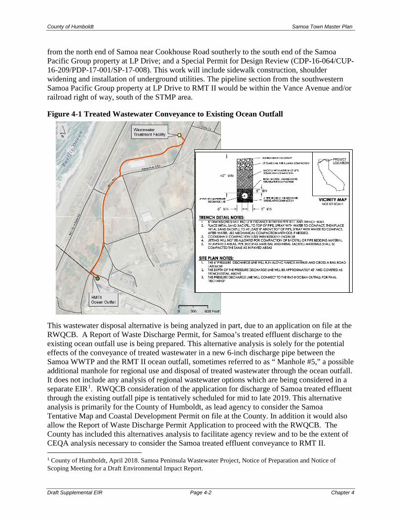
County of Humboldt Samoa Town Master Plan
Draft Supplemental EIR Page 4-2 Chapter 4
from the north end of Samoa near Cookhouse Road southerly to the south end of the Samoa Pacific Group property at LP Drive; and a Special Permit for Design Review (CDP-16-064/CUP-16-209/PDP-17-001/SP-17-008). This work will include sidewalk construction, shoulder widening and installation of underground utilities. The pipeline section from the southwestern Samoa Pacific Group property at LP Drive to RMT II would be within the Vance Avenue and/or railroad right of way, south of the STMP area.
Figure 4-1 Treated Wastewater Conveyance to Existing Ocean Outfall
This wastewater disposal alternative is being analyzed in part, due to an application on file at the RWQCB. A Report of Waste Discharge Permit, for Samoa’s treated effluent discharge to the existing ocean outfall use is being prepared. This alternative analysis is solely for the potential effects of the conveyance of treated wastewater in a new 6-inch discharge pipe between the Samoa WWTP and the RMT II ocean outfall, sometimes referred to as “ Manhole #5,” a possible additional manhole for regional use and disposal of treated wastewater through the ocean outfall. It does not include any analysis of regional wastewater options which are being considered in a separate EIR1. RWQCB consideration of the application for discharge of Samoa treated effluent through the existing outfall pipe is tentatively scheduled for mid to late 2019. This alternative analysis is primarily for the County of Humboldt, as lead agency to consider the Samoa Tentative Map and Coastal Development Permit on file at the County. In addition it would also allow the Report of Waste Discharge Permit Application to proceed with the RWQCB. The County has included this alternatives analysis to facilitate agency review and to be the extent of CEQA analysis necessary to consider the Samoa treated effluent conveyance to RMT II. 1 County of Humboldt, April 2018. Samoa Peninsula Wastewater Project, Notice of Preparation and Notice of Scoping Meeting for a Draft Environmental Impact Report.

County of Humboldt Samoa Town Master Plan
Draft Supplemental EIR Page 4-3 Chapter 4
The pipe construction will be coordinated with the planned improvements of Vance Avenue, from the approved wastewater treatment facility to LP Drive. From there, the trenching and pipe installation will occur within and adjacent to the existing Vance Avenue alignment to the RMT II ocean outfall near Manhole #5. An adjacent manhole is proposed for regional use. Trenching is expected to be conducted primarily within the existing Vance Ave. paved roadway. Given the relatively sandy subsurface materials on the Samoa Peninsula, it is expected that standard excavation equipment will be sufficient for wastewater conveyance pipe trenching. Bedding, pipe installation and backfilling are also expected to be completed using customary construction practices and equipment. Construction of the project requires installation and maintenance of best management practices (BMPs) to reduce the risk of impacts from construction activities to waters of the state. Operators and the construction manager will be informed of observational practices for identifying artifacts and inadvertent discovery practices to follow should artifacts be discovered during excavation operations. Hence, since the proposed 6-inch line would be installed under an existing paved roadway, backfilled with native soils, and appropriate construction BMP’s would be in place, there are not expected to be substantial adverse impacts from installation of this 6-inch treated wastewater conveyance line. Since the line would be installed underground within an existing road right of way, it would not substantially alter existing drainage patterns of the site or area or increase the rate of surface runoff. Because the proposed treated wastewater conveyance line would be installed underground in an existing right of way in the central portion of the Samoa Peninsula, it is expected that potential impacts from sea level rise would be similar to the surrounding areas. Sea level is expected to rise at least 16 inches along the California coast by 2050.2 Low lying areas in the project area are susceptible to inundation due to future sea level rise; however, according to Humboldt County Web GIS mapping, the proposed discharge line route is not in an area projected to be inundated by one meter of sea level rise. Therefore, potential impacts due to sea level rise are not considered to be substantially greater for the proposed project than for existing infrastructure and roadways in the area. Additionally, STMP development must consider up to five feet of future sea level rise (STMP (New Development) Policy 1B.I.A.9). RMT II Ocean Outfall Pipe Background/ Existing Conditions. The on-shore end of the outfall is located adjacent to RMT II. Effluent is discharged through an existing submerged outfall that is approximately 8,200 feet (2,497 m) long and terminates in an 852-foot (258-meter) multiport diffuser aligned perpendicular to the shoreline. The diffuser contains a total of 144 ports, each with a diameter of 2.4 inches Ports are paired, so that there are 72 ports on each side of the barrel (pipe) with a spacing of 12 feet (3.66 m) on center between ports. The diffuser has a 36-inch (0.91-m) internal diameter, and its ports discharge at a 45-degree vertical orientation, as shown below. The diffuser is approximately 82 feet (25 meters
2 Climate Change Impacts: Sea Level Rise. https://www.humboldtbaykeeper.org/humboldt-bay-information/bay-issues/305-climate-change-impacts-sea-level-rise . Accessed October 15, 2018.

County of Humboldt Samoa Town Master Plan
Draft Supplemental EIR Page 4-4 Chapter 4
maximum depth) below the surface.3 According to Harbor District staff, many ports are temporarily plugged so that they won’t fill with sediment due to lack of flow through the pipe. The Samoa Peninsula outfall capacity is defined by pipe diameter, number of available diffuser ports, and port diameter. Available dilution capacity is controlled by effluent flow rate and density. Hydraulic assessment indicates the outfall can discharge up to 40 million gallons per day (MGD) based on 144 2.4-inch ports, however higher salinity content effluent will reduce dilution. At its heaviest historic flows, the outfall was used to discharge approximately 15 MGD of treated industrial wastewater from the Pulp Mill into the Pacific Ocean.
The existing ocean outfall is currently used to discharge approximately 170,000 gallons per day (gpd) of process water from DG Fairhaven Power. The total hydraulic capacity of the outfall is estimated at 40 MGD for discharges. Treated effluent, conforming to Regional Water Quality Control Board discharge requirements, from the proposed Samoa WWTF would be routed to an ocean outfall connection point at RMT II, a pump station consisting of a manhole/wet well with duplex pumps. Total Daily Flow of treated wastewater from the Samoa facility at full build-out is projected to be 53,000 gpd, less than one percent of total outfall hydraulic capacity. There would be no physical change to the outfall facility to accommodate this flow volume.
If the current use by DG Fairhaven Power (170,000 gpd) is combined with the calculated cumulative impact of the addition of treated effluent from the Town of Samoa (53,000 gpd), the outfall pipe will be functioning at 0.7% of its recommended maximum daily capacity of 40,000,000 gallons per day (40 MGD). Using the accepted conservative estimate of 5% annual growth rate, current industrial use with the addition of the Samoa Town Master Plan development will reach 1.0% of the pipeline’s daily capacity by 2030. Because the outfall is an existing facility, with much greater capacity than needed for Samoa treated wastewater, the use of the RMT II outfall pipe would not have a significant effect on the existing outfall pipe capacity or use. Potential Environmental Impacts of Off-site Treated Wastewater Disposal Alternative This section evaluates the potential impacts to biological and hydrological resources during construction and operation of the wastewater disposal pipeline alternative. The alternative site includes active roadways, and other areas primarily covered with old asphalt, fractured concrete, compacted gravel on former log decks, and old railroad infrastructure. As mentioned above, installation of the wastewater collection system is proposed to occur within the existing roadways to minimize impacts to sensitive coastal habitat, although ground disturbance may occur approximately ten feet beyond existing edge of pavement. Information in this section is based in part on the Samoa Peninsula Wastewater Project EIR currently being prepared for the County of Humboldt by GHD Inc. and SHN Consulting Engineers and Geologists. The analysis also draws upon special-status plant and animal species surveys that were conducted by SHN in March and July 2017 and April, May, and June 2018. 3 SHN Engineers and Geologists, February 2016. Redwood Marine Terminal II Infrastructure Needs and Reuse on the Samoa Peninsula. Prepared for County of Humboldt and Humboldt Bay Harbor, Recreation, and Conservation District.

County of Humboldt Samoa Town Master Plan
Draft Supplemental EIR Page 4-5 Chapter 4
Potential Biological Impacts The project has the potential to disturb sensitive species either directly or through habitat modifications, including hydrological interruption and discharge. It is assumed pipeline construction will have no significant adverse impact upon marine species or habitat, and pipeline operations will have no significant adverse impact upon land-based species or habitat.
Impact WWAlt-BIO 1: Adverse effects to special-status species and/or habitat
• Would the alternative have a substantial adverse effect, either directly or through habitat modifications, on any species identified as a candidate, sensitive, or special-status species in local or regional plans, policies, or regulations, or by the California Department of Fish and Wildlife or U.S. Fish and Wildlife Service?
• Would the alternative threaten to eliminate a marine plant or wildlife community or cause a fish or marine wildlife population to drop below self-sustaining levels?
Based on review of species’ life history and geographic distribution data, habitat requirements, and other available species information, several special-status wildlife species have a potential for occurrence within the project vicinity. However, site-specific investigations show that actual habitat at the alternative site provides low suitability for many of these species; therefore, they are not expected to be present at the site and are not considered further.
Impact WWAlt-BIO 1.1: Construction Impacts
Marine Impacts
As mentioned above, it is assumed construction will have no significant adverse impact upon marine species or habitat, and operations will have no impact upon land-based species or habitat.
Project construction includes improvements that would connect to the existing Redwood Marine Terminal (RMT II) ocean outfall and diffuser system which is considered an outfall line per section 30233 of the Coastal Act. Project construction does not include any in-water infrastructure installation or near-water construction activities; therefore, there would be no impact to marine special-status species.
Land-based Impacts: Special Status Plants
No special-status plant species were observed during seasonally-appropriate botanical surveys of the pipeline area (SHN 2017). The alternative is not likely to affect rare plant species or their habitats due to lack of presence during surveys, lack of habitat within the area, surrounding industrial conditions, and disturbed nature of the area.
Land-based Impacts: Special Status Wildlife
Special status wildlife species (birds, mammals, amphibians, fish, insects) are not likely to be affected by this alternative. Riparian and wooded areas will not be impacted, no trees will be removed, and no significant vegetation clearing is expected to occur. Construction is proposed to occur within previously developed areas, including a former log deck, the railroad right of way, and alongside Vance Avenue. There may be some noise-related disturbance associated with the

County of Humboldt Samoa Town Master Plan
Draft Supplemental EIR Page 4-6 Chapter 4
construction of the project; however, a buffer will be maintained between construction, wetlands, and ESHA (the only areas that contain significant vegetation cover). Construction activities are comparable to existing ongoing industrial operations at the site (including recycling processing, log deck storage and chipping, and small scale industrial operations within the pulp mill buildings) and it is not anticipated that the project will have a significant impact on special status birds. Osprey nests were observed approximately 1,350 feet to the east of the project area along Humboldt Bay. Construction will maintain buffer between construction and nesting osprey.
Nesting birds are not likely to be affected by this project as no substantial vegetation removal is proposed and above-ground disturbance will be limited to construction at previously developed areas. While construction activities associated with the project will temporarily elevate noise levels, birds nesting within and immediately adjacent to the project area are subject to constant disturbance from existing industrial use and traffic on Vance Ave. and New Navy Base Road; therefore, it is unlikely that birds nesting within such a setting would be persuaded to leave the nest due to construction noise disturbance. Equipment noise within the project area is not likely to exceed that which regularly occurs onsite with near-by ongoing industrial operations, including log deck storage and chipping, and recycling processing.
Land-based Impacts: Sensitive Habitat
The following three sensitive natural communities (designated S3 as assigned by the California Department of Fish and Wildlife) exist within the study area for this alternative and are considered Environmentally Sensitive Habitat Area (ESHA) by the California Coastal Commission: coastal dune willow thicket, coastal brambles vegetation, and wax myrtle scrub (SHN 2017). In addition, two wetlands were documented near the pipeline alignment (SHN 2017). No substantial vegetation clearing is anticipated with this alternative, and the majority of vegetation communities will have a 100-foot buffer between them and construction.
Sensitive vegetation communities and wetlands are not anticipated to be directly impacted during the project. The plan to limit installation of the pipelines to within the existing roadways and railroad right of ways would generally avoid ESHA. However, construction activities have the potential to impact ESHAs that are immediately adjacent to the work area where ground disturbance may occur out to 10 feet beyond existing pavement. Sediment transfer from construction activities could indirectly impact roadside wetlands. Vegetation communities will be protected by a 100-foot buffer or a reduced buffer where a 100-foot buffer is determined to be infeasible. If a reduced setback is determined to be the least environmentally damaging feasible alternative, then a reduced wetland setback justification will be written, with information stating why a reduced buffer is justified. Therefore, a less than significant impact to sensitive natural communities and wetlands is anticipated from this alternative.
Impact WWAlt-BIO 1.2: Operation Impacts
Marine Impacts
Currently, DG Fairhaven Power, located between Fairhaven and Samoa, discharges approximately 170,000 gallons per day (gpd) of processed water, following treatment, through

County of Humboldt Samoa Town Master Plan
Draft Supplemental EIR Page 4-7 Chapter 4
the RMT II ocean outfall. Total Samoa Town Master Plan improvements would add approximately 53,000 gpd, bringing the total estimated daily flow through the outfall to approximately 223,000 gpd. If unregulated, biological resources in the vicinity of the outfall diffuser including benthic and pelagic organisms may be impacted by changes to water quality, discharges of settleable particles or nutrients, and changes to water currents.
Increased nutrient inputs in an aquatic environment promote excessive growth of phytoplankton and macro algae which can block sunlight to submergent vegetation. Changes in naturally occurring amounts of nutrients can potentially cause blooms of toxic algae which eventually die off, then the bacteria decomposing the algae consume oxygen, reducing oxygen availability for other organisms. Offshore winds cause colder deep water to replace surface water that has been warmed by the sun. The ocean water is constantly churning underneath, bringing nutrients up to the top. Therefore, impacts to water quality may not only affect ocean floor marine organisms, but could affect surface feeding animals as well.
However, the approved Samoa WWTF would be required to obtain an NPDES permit which would specify an acceptable level of a pollutant or pollutant parameter including physical properties, solids, biologicals, and chemicals in a discharge and make sure that the state's mandatory standards for clean water and the federal minimums are met. The NPDES permit would be required to be amended to accommodate increased flow from the project. The anticipated effluent water quality limits, established to protect the beneficial uses of the ocean including marine habitat and fish migration, are the regulated standards that would be required to be met during operation, prior to discharge through the ocean outfall pipe.
The NPDES permit would require monitoring to determine compliance with established effluent limitations, establish a basis for enforcement actions, assess treatment efficiency, characterize effluents, and characterize the receiving water. The NPDES regulations require the permittee to maintain records and periodically report on monitoring activities. Because ocean outfall is regulated by existing standards established for the purpose of protecting the ocean, and the additional flow from the project would contribute a small fraction of the existing discharge and approved Samoa WWTF discharge, the impact to the ocean environment from increased discharge from the project would be less than significant.
Land-based Impacts
As mentioned above, it is assumed construction will have no significant adverse impact upon marine species or habitat, and operations will have no impact upon land-based species or habitat. Operation of the improvements to the WWTF would not impact land-based special-status species or EHSA. Long-term operations and maintenance of the collection system will take place within the paved and developed areas of the project. With implementation of the improvements, there would be few changes to the operation of the approved Samoa WWTF such that it would result in substantial impacts to special-status species. The pipelines would be underground, and neither noise nor lighting would increase to an extent that would be noticeable let alone create a substantial impact. Land-based impacts from pipeline operation would be less than significant.

County of Humboldt Samoa Town Master Plan
Draft Supplemental EIR Page 4-8 Chapter 4
Impact WWAlt-BIO 1 Summary
No impact to marine species is expected to occur as a result of pipeline construction. Direct short-term impacts to land-based biological resources (riparian habitat, ESHAs, or other sensitive natural communities) are not expected to occur during project construction along roadways. Sediment transfer from construction activities could indirectly impact roadside wetlands and water quality. With implementation of applicable NCRWCB permits, in addition to project specific mitigation measures and BMPs, potential impacts would be avoided, minimized and otherwise reduced to a less than significant level. For land-based habitat areas, impacts to biological resources would be less than significant with incorporation of applicable existing 2009 MEIR mitigation measures and mitigation measures below.
No impact to land-based sensitive habitat areas would occur during operation of the project. The project’s operational throughput would continue to be required to meet regulatory requirements of the NPDES permit, governed by the requirements and approval of the NCRWQCB. Therefore, impacts from project operation on marine biological resources would be less than significant.
Mitigation Measure WWAlt-BIO1a: Preconstruction nesting bird surveys. If vegetation clearing is necessary for pipeline construction, preconstruction nesting bird surveys shall be conducted by a qualified biologist if construction begins in the breeding season (January 15 to August 31 to include raptors and all other migratory birds). Surveys are to be conducted within seven days of construction activities and repeated if construction ceases for seven days in the same location, prior to construction resuming. An area of at least 500 feet within the construction area will be surveyed for nesting birds. If active nests are found, the biologist will monitor the nest(s) and establish protective buffers (no-disturbance area around the nest) determined with consultation with CDFW and based on the nesting species, its sensitivity to disturbance, and type of and duration of disturbance expected.
Any work conducted within 500 feet of an osprey nest will either be conducted outside of the nesting season (March through August) or a qualified biologist in consultation with CDFW will observe the nests prior to the commencement of construction within the vicinity of the nests to ensure that juveniles have fledged, and that the nest is empty during construction, or determine an adequate buffer that will not impact the nest or nestlings.
Impacts to special-status species can be minimized by mitigation measures implemented prior to and during construction by identifying the locations of natural resources and establishing and maintaining a protective buffer around them through the duration of the project activities. Minimizing the impact of construction activities by adhering to the above mitigation measures during the breeding season will avoid significant impacts to local wildlife and plant populations. Establishing, maintaining, and monitoring protective buffers around sensitive natural communities during construction of the project would protect the sensitive natural communities and reduce the potential indirect impact during construction to less than significant.
Mitigation Measure WWAlt-BIO1b: Protect Wetlands During Pipeline Construction: Prior to the start of construction, where construction activities occur within close proximity (100 feet) to delineated wetlands, high visibility construction fencing shall be erected to establish a no-

County of Humboldt Samoa Town Master Plan
Draft Supplemental EIR Page 4-9 Chapter 4
disturbance buffer that would be adequate for the protection of the wetlands, determined by a qualified biologist. The fencing shall be checked weekly by a biological monitor to ensure its continued correct placement and stability.
Avoiding wetlands through the appropriate use of BMPs and protective setbacks would reduce the impact on wetlands to less than significant.
Impact WWAlt-Bio 2: Impacts to Wildlife Migration Patterns
Would the alternative interfere substantially with the movement of any native resident or wildlife species or with established native resident or migratory wildlife corridors, or impede the use of native wildlife nursery sites?
Humboldt Bay is along the Pacific Flyway and is considered an internationally important area for migratory birds by the American Bird Conservancy and the Western Hemisphere Shorebird Reserve Network. Dune forest and riparian areas around Humboldt Bay provide habitat for breeding and non-breeding migratory birds. The project area is composed of a mixture of developed and undeveloped coastal dune and wetland habitat on a narrow spit of land between Humboldt Bay and the Pacific Ocean. It is unlikely that large scale terrestrial linkages exist, however local wildlife movement corridors exist across the Samoa Peninsula and wildlife movement is expected to be concentrated along shrubby and vegetated areas including wetlands and vegetated swales. There are no identified wildlife nursery sites within the project area.
Construction Impacts
Wildlife corridors are not anticipated to be impacted by the proposed effluent pipeline alternative. The pipeline area is located on the isolated north spit, with little vegetation cover. While this area is used as a flyover path for migratory birds, the lack of vegetation on site make it unlikely that the project area is used for resting. The industrial and isolated nature of the site makes it unlikely that the project area is used as a wildlife movement corridor. No substantial vegetation removal would occur along the pipeline alignments. Due to the disturbed and developed nature of the areas proposed for construction, impacts on the movement of wildlife or migratory corridors would be less than significant.
Project construction does not include any in-water infrastructure installation, equipment use, or otherwise create any barrier or impediment that would interfere with marine wildlife movement or the use of native marine wildlife nursery sites. Therefore, there would be no impact on the marine environment.
Operation Impacts
Project operation will not create any significant barrier that would prevent wildlife movement through the project area; there is no impact to avian or other wildlife movement.
Project operations would not include any in-water infrastructure installation, equipment use, or otherwise create any barrier or impediment that would interfere with marine wildlife movement or the use of native marine wildlife nursery sites. With regard to water quality in general, and its
County of Humboldt Samoa Town Master Plan
Draft Supplemental EIR Page 4-10 Chapter 4
potential impact on species occurring in the vicinity of the outfall, refer to the analysis under Impact WWAlt-BIO 1. The impact would be less than significant.
Impact WWAlt-BIO 2 Summary
Due to the disturbed and developed nature of the areas proposed for construction, impacts on the movement of wildlife or migratory corridors from construction would be less than significant.
Because project operations will not create any significant barrier that would prevent wildlife movement through the project area, or create any barrier or impediment that would interfere with marine wildlife movement or the use of native marine wildlife nursery sites, the impact from operations would be less than significant.
Impact WWAlt-BIO 3: Cumulatively Considerable Impacts
Would the alternative result in a cumulatively considerable contribution to cumulative impacts related to biological resources?
Known projects that may, or are currently proposed to occur in the area of the alternative, consist of the Coast Seafoods onshore shellfish hatchery at RMT II and the Samoa Peninsula Wastewater Project.
The Coast Seafoods proposed project (Coastal Development Plan [CDP] 9-16-0033) would construct and operate an onshore shellfish hatchery at the RMT II facility. If this project was developed at a future date, its development would be on a site that has been historically developed for commercial and industrial uses, and implementation of the project is not expected to have significant impact on biological resources. Discharge of any wastewater from the facility would only be allowed through other regulatory permits developed specifically for that project. Details of this project are not known at this time, and future analysis of this project would be required through other CEQA documents and associated regulatory permits.
The Samoa Peninsula Wastewater Project EIR is currently being prepared. Under this proposed project the Samoa wastewater treatment system would be enlarged incrementally as new development progresses on the Samoa Peninsula. While these developments may have the potential to impact biological resources, implementation of site specific mitigation measures and permit conditions would be developed to reduce impacts to less than significant levels.
When evaluating the alternative, in light of the other approved and known potential projects in the immediate vicinity, the treated wastewater conveyance for off-site disposal alternative is not anticipated to contribute to a cumulatively considerable impact to biological resources. This is because the alternative and the other projects impacts would be fully evaluated and mitigated to a less than significant level. In addition, because the outfall is an existing facility, with much greater capacity than needed for Samoa treated wastewater and the projects mentioned above, the use of the RMT II outfall pipe would not have a significant effect on the existing outfall pipe capacity or use when operated in accordance with other required regulatory approvals.
While the proposed project could impact biological resources, the implementation of uniform development standards (including federal, state and local plans, policies and regulations, in

County of Humboldt Samoa Town Master Plan
Draft Supplemental EIR Page 4-11 Chapter 4
addition to project specific mitigation measures and BMPs) would result in biological impacts being avoided, minimized and otherwise reduced to a less than significant level. The project’s contribution to cumulative impact would not be considerable and are considered less than significant.
Biological Resources Impacts Summary
There are no significant additional impacts to biological resources as a result of pipeline construction and operation in addition to the analysis included in the 2009 MEIR and Section 3.2 of this SMEIR. The proposed pipeline construction and operation would not significantly impact any populations of marine or land-based special-status species, natural communities, or the movement of wildlife. Potential biological impacts are not expected to be cumulatively considerable. Potential Hydrological Impacts Potential impacts to water quality are evaluated for both construction and operational activities. Construction impacts are evaluated for their potential to violate water quality standards and waste discharge requirements. The evaluation also considers additional runoff from new impervious areas, and whether the treatment techniques proposed as part of the project will provide adequate treatment in accordance with applicable regulations. Impact WWAlt-HYDRO 1: Violations of Applicable Standards
Would the project violate any water quality standards or waste discharge requirements or otherwise substantially degrade water quality?
Construction Impacts
Construction of the pipeline and improvements to the Approved Samoa WWTF could generate discharges to water resources that could potentially violate water quality standards or waste discharge requirements. Project construction does not include any in-water infrastructure installation or near-water construction activities; therefore, there would be no impact to marine water quality.
Impacts to surface water quality as attributable to the alternative would be reduced to a less than significant level through the inclusion of focused BMPs for the protection of surface water resources. Improvements related to the 3,600 lineal foot pipeline would be located underground. The alternative would not result in an alteration of surface slopes, and there are no streams or rivers in, or adjacent to the project site. Therefore, the alternative will not substantially alter existing drainage patterns of the site or area, including altering a stream or river or increase the rate of surface runoff that would results in substantial erosion or siltation or flooding.
Construction of the alternative would involve excavation, soil stockpiling, grading, and the installation of sewer pipe. There are multiple construction related activities that could have potential direct or indirect impacts on the water quality of local surface water features and shallow groundwater resources, including: sedimentation, erosion, handling hazardous materials,

County of Humboldt Samoa Town Master Plan
Draft Supplemental EIR Page 4-12 Chapter 4
and dewatering. Existing MEIR mitigation measures require compliance with NCRWCB permit requirements including identifying measures to prevent stormwater pollution caused by construction activities. These measures include controlling and covering construction materials and wastes during construction, the use of silt fences to collect sediment and site stabilization following construction (MEIR mitigation measures 4.5.2a-e, 4.5.3a-b).
With implementation of applicable NCRWCB permits, in addition to project specific mitigation measures and BMPs, potential water quality impacts would be avoided, minimized and otherwise reduced to a less than significant level. The alternative would not create or contribute runoff water which would exceed the capacity of existing or planned stormwater drainage systems, provide substantial additional sources of polluted runoff, or otherwise substantially degrade water quality. The alternative may require dewatering in the immediate vicinity of excavations and installation of underground features at areas where groundwater depths are shallow. Impacts on groundwater would be reduced to a less than significant level by requiring construction dewatering permits.
Operation Impacts
Project operation would collect, process, and dispose of wastewater from existing facilities and potential future infill development consistent with HBAP and zoning. Treated wastewater would be disposed of through the RMT II ocean outfall pipe, which extends 1.5 miles offshore. Currently, DG Fairhaven Power, located between Fairhaven and Samoa, discharges approximately 170,000 gallons per day (gpd) of processed water, following treatment, through the RMT II ocean outfall. Total estimated daily flow of Samoa treated wastewater through the outfall is approximately 53,000 gpd, less than one percent of total outfall hydraulic capacity. There would be no physical change to the outfall facility to accommodate this flow volume.
If not properly managed, water quality in the vicinity of the outfall diffuser could violate a water quality standard or waste discharge requirement. However, the Approved Samoa WWTF would be required to obtain an NPDES permit which would specify an acceptable level of a pollutant or pollutant parameter including physical properties, solids, biologicals, and chemicals in a discharge and make sure that the state's mandatory standards for clean water and the federal minimums are met..
Anticipated effluent water quality limits have been established to protect the beneficial uses of the ocean including marine habitat and fish migration. These are the regulated standards that would be required to be met during operation, prior to discharge through the ocean outfall pipe. The NPDES permit would require monitoring to determine compliance with established effluent limitations, establish a basis for enforcement actions, assess treatment efficiency, characterize effluents, and characterize the receiving water. The NPDES regulations require the permittee to maintain records and periodically report on monitoring activities. Because ocean outfall is regulated by existing standards established for the purpose of protecting the ocean, and the additional flow from the project would contribute a small fraction of the existing discharge and Approved Samoa WWTF discharge, the impact to the ocean environment from increased discharge from the project would be less than significant.

County of Humboldt Samoa Town Master Plan
Draft Supplemental EIR Page 4-13 Chapter 4
Impact WWAlt-HYDRO 1 Summary
Construction of the project, if not properly managed, has the potential to violate water quality standards. However, with implementation of applicable NCRWCB permits, in addition to project specific mitigation measures and BMPs, potential water quality impacts would be avoided, minimized and otherwise reduced to a less than significant level. Additionally, with the application of effluent water quality limits and other regulations associated with required permits, the impacts of the project will be limited. Operation of the project’s improvements at the Approved Samoa WWTF is estimated to improve water quality by removing existing negative effects to groundwater quality from continued use and potential future failure of existing private septic systems within Samoa Peninsula. Impact WWAlt-HYDRO 2: Cumulatively Considerable Impacts
Would the project result in a cumulatively considerable contribution to cumulative impacts related to hydrology and water quality?
The geographic scope for the analysis of potential cumulative hydrology and water quality impacts in the study area consists of the project site and the immediately surrounding areas of the Samoa Peninsula. Known projects that may, or are currently proposed to occur in the area of the alternative, consist of the Coast Seafoods onshore shellfish hatchery at RMT II and the Samoa Peninsula Wastewater Project.
Operation of the Samoa WWTF is estimated to improve water quality by removing existing negative effects to groundwater quality from continued use and potential future failure of existing private septic systems within Samoa Peninsula. Relevant cumulative projects identified in this section would also be subject to compliance with applicable NCRWQCB permits and therefore would similarly have a less than significant impact to water quality.
Relevant cumulative projects disturbing more than one acre of land would also be subject to the NPDES General Construction Permit, which would require development and implementation of SWPPPs to avoid water quality impacts. Therefore, with implementation of existing mitigation measures and BMPs, the project’s potential contribution to any such cumulative water quality impact would not be cumulatively considerable.
Hydrological Resources Impact Summary
There are no significant additional impacts to hydrological resources as a result of pipeline construction in addition to the analysis included in the 2009 MEIR. With the incorporation of appropriate BMPs and 2009 MEIR mitigation measures, the proposed pipeline construction and operation would not significantly impact surface water quality, stormwater system capacity, or ground water. Potential hydrologic impacts are not expected to be cumulatively considerable.
County of Humboldt Samoa Town Master Plan
Draft Supplemental EIR Page 4-14 Chapter 4
4.2 CUMULATIVE IMPACTS CEQA Guidelines Section 15355 defines “cumulative impacts” as “two or more individual effects that, when considered together, are considerable or that compound or increase other environmental impacts.” In general, these impacts occur in conjunction with other related developments whose impacts might compound or interrelate with those of the project under review. In accordance with Section 15130 of the CEQA Guidelines, the 2009 MEIR analyzes the cumulative impacts that could occur with the proposed project. In order to analyze the cumulative impacts of the project in combination with existing development and other expected future growth, the amount and location of growth expected to occur (in addition to the project) must be considered. As stated in CEQA Guidelines Section 15130(b), this reasonably foreseeable growth may be based on either of the following, or a combination thereof:
• A list of past, present, and probable future projects producing related or cumulative impacts, including, if necessary, those projects outside the control of the agency; or
• A summary of projections contained in an adopted General Plan or related planning document, or in a prior environmental document which has been adopted or certified, which described or evaluated regional or area-wide conditions contributing to cumulative effect.
The 2009 MEIR included a list of past, present, and probable future projects producing related or cumulative impacts and an analysis for each environmental topic. That analysis remains valid with the additions listed below. Cultural Resources The proposed Master Plan would include impacts to historic resources and includes mitigations to reduce most potential impacts to a less-than-significant level; however, the potential impacts from demolition of historic resources remains a significant and unavoidable impact even with mitigation. Consequently, the Master Plan’s contribution to the cultural impacts would be cumulatively considerable. Biological Resources There are no additions to the biological resources cumulative analysis; as described in the 2009 MEIR and Section 3.2 of this SMEIR, the proposed project would not significantly impact any populations of special-status species, natural communities, or the movement of wildlife. Potential biological impacts are not expected to be cumulatively considerable. Greenhouse Gas Emissions As discussed in Section 3.3 of this SMEIR, GHG emission are not confined to a particular air basin but are dispersed worldwide. Hence GHG impacts are by nature a cumulative impact. Therefore, impacts described under Impact 3.3.1 are the proposed project’s contribution to this cumulative impact. Because the project’s GHG emissions were considered less than significant,

County of Humboldt Samoa Town Master Plan
Draft Supplemental EIR Page 4-15 Chapter 4
the cumulative effects of the project on GHG emissions and contribution to global climate change would be less than significant. Transportation 2009 MEIR Section 4.2 evaluated the proposed Master Plan’s potential transportation impacts to the plan area and vicinity. The section evaluates Master Plan impacts to S.R 255 as far north as the S.R.255/U.S. 101 interchange in Arcata, and the S.R. 255/U.S. 101 intersections in Eureka. Mitigation measures include contributions to transportation improvements outside the plan area in both Eureka and Manila. Section 3.4 of this SMEIR incorporates relevant information from the Samoa Industrial Waterfront Preliminary Transportation Access Plan and describes potential traffic impacts generated by development in the Samoa industrial waterfront area, including the Samoa Town Master Plan. 2009 MEIR Section 4.2 and Section 3.4 of this SMEIR should be considered an analysis of the potential cumulative transportation related impacts of the proposed Master Plan. Town of Samoa transportation impacts were further analyzed in 2017, as part of the MND for CDP-16-064/CUP-16-209/PDP-17-001/SP-17-008. 4.3 GROWTH INDUCING IMPACTS Information regarding growth-inducing impacts caused by the project is the same as discussed in the 2009 MEIR, which is hereby incorporated by reference. No new information has arisen and no changes in circumstances have occurred that affect this analysis. 4.4 SIGNIFICANT IRREVERSIBLE ENVIRONEMTNAL
EFFECTS Information regarding significant irreversible environmental changes caused by the project is the same as discussed in the 2009 MEIR, which is hereby incorporated by reference. No new information has arisen and no changes in circumstances have occurred that affect this analysis. 4.5 NEW UNAVOIDABLE SIGNIFICANT ENVIRONMENTAL
EFFECTS As discussed in Section 3.1 of this MEIR, the project would result in new significant impacts to historic resources due to demolition of contributing structures. Information regarding the significant and unavoidable environmental impacts resulting from the project is also discussed in the 2009 MEIR, and the conclusions of the 2009 MEIR are still valid. That information is hereby incorporated by reference.

County of Humboldt Samoa Town Master Plan
Draft Supplemental EIR Page 4-16 Chapter 4
4.6 MITIGATION MEASURES Summary Table S-1 (Summary of Environmental Effects and Mitigation Measures) identifies the environmental effects and proposed mitigation measures identified in this SMEIR. Additionally, Appendix G (2009 MEIR Mitigation Measures) provides a comprehensive identification of the adopted mitigation measures from the 2009 MEIR. References SHN Consulting Engineers and Geologists, GHD Inc. 2018. County of Humboldt Samoa
Peninsula Wastewater Project Administrative Draft EIR, Chapter 4.3-Biological Resources and Chapter 4.9 Hydrology and Water Quality. Draft prepared for County of Humboldt.
SHN Consulting Engineers and Geologists. 2017. County of Humboldt Natural Resources
Assessment for Samoa Peninsula Wastewater Project. Prepared for County of Humboldt. SHN Consulting Engineers and Geologists. 2017. County of Humboldt Wetland Delineation and
Other Waters Delineation Report, Samoa Peninsula Wastewater Project. Prepared for County of Humboldt.

County of Humboldt Samoa Town Master Plan
Draft Supplemental MEIR Page 5-1 Chapter 5
CHAPTER 5
DOCUMENT PREPARERS EIR Preparers/ Consultants Planwest Partners Inc. Illingworth & Rodkin Inc., Greenhouse Gas Emission Assessment Abbay Technical Services, Energy Consumption Consulting