2012 tuggeranong town centre master plan - · pdf filethe tuggeranong town centre master...
TRANSCRIPT

Tuggeranong town centre
master plan
SEPTEMBER 2012

The ACT Government is committed to making its information, services, events and venues accessible to as many people as possible. If you have difficulty reading a standard printed document and would like to receive this publication in an alternative format — such as large print or audio — please telephone 02 6207 7307.
If English is not your first language and you require the translating and interpreting service please telephone 131 450. If you are deaf or hearing impaired and require the TTY typewriter service please telephone 02 6207 2622.

Tuggeranong town centre master plan i
Project context1 Introduction ........................................................ 1
1.1 Study area ............................................................... 2
1.2 Master planning process ........................................ 4
2 Background ......................................................... 6
2.1 History ................................................................... 6
2.2 Lease holders .......................................................... 7
2.3 Opportunitiesandconstraints ............................... 8
2.4 Communityconsultation ..................................... 10
The master plan3 The vision and outcomes .................................. 13
3.1 Planning and design strategies ............................ 18
3.2 The master plan .................................................... 28
4 Key actions and design elements ...................... 31
4.1 Land use ................................................................ 31
4.2 Precinct character ................................................ 36
4.3 Public transport .................................................... 40
4.4 Pedestrian and cyclist network ............................ 42
4.5 Street hierarchy .................................................... 44
4.6 Building heights .................................................... 56
4.7 Activefrontages ................................................... 58
4.8 Naturalfeaturesandpublicopenspace .......................... 60
4.9 Car parking and loading ....................................... 62
4.10 Foodproduction ................................................... 64
Implementation5 Implementation ................................................ 67
5.1 Potentialtiming .................................................... 68
6 Catalyst projects ............................................... 70
7 Conclusion ....................................................... 72
7.1 Next steps ............................................................. 72
Attachment A .................................................... 74
Table of contents
Abbreviations and acronyms
ACTPLA - ACT Planning and Land Authority (which is now incorporated into ESDD)
EDD-EconomicDevelopmentDirectorate
ERG-ExpertReferenceGroup
ESDD-EnvironmentandSustainableDevelopmentDirectorate
IAAG-InteragencyAdvisoryGroup
LDA-LandDevelopmentAgency
NCDC-NationalCapitalDevelopmentCommission
RL-Relativelevel
TBC-Tobeconfirmed
The lake - Lake Tuggeranong
Theriver-MurrumbidgeeRiver

ACT Government | Environment and Sustainable Development Directorate ii
© Australian Capital Territory, Canberra 2012
ISBN 978-1-921117-12-1
Thisworkiscopyright.Apartfromanyuseaspermittedunderthe Copyright Act 1968, no part may be reproduced without thewrittenpermissionoftheEnvironmentandSustainableDevelopmentDirectorate,GPOBox158,CanberraACT2601.
Published by the EnvironmentandSustainableDevelopmentDirectorate.
Enquiries: Canberra Connect 13 22 81.
Website: www.environment.act.gov.au
Printed on recycled paper

Tuggeranong town centre master plan iii
ExistingTuggeranongforeshorearea.

Throughoutthisdocumentblocksandsectionsarereferredto.Thismapprovidesaquickreferencetohelpthereaderorientatethemselves.
ACT Government | Environment and Sustainable Development Directorate iv

Tuggeranong town centre master plan 1
Project context1 Introduction
ThisreporthasbeenproducedbytheACTGovernment’sEnvironmentandSustainableDevelopmentDirectorate(ESDD,whichincorporatestheformerACTPLA).Itdocuments:
• the project context, including the master planning process, background research and analysis and communityconsultation
• theactualmasterplananditsrecommendations,and
• howthemasterplananditsrecommendationscanbeimplemented.
Canberraisadesignedcitywithahierarchyoftown,groupand local centres that were planned in accordance with social,environmentalandeconomicvaluesappropriatetotheirtime.
Sinceitsoriginalplanning,Canberrahasdevelopedandchangedsignificantly.Changesinpopulationanddemographicshavecreatednewdevelopmentpressuresforthe city.
The Tuggeranong town centre master planning project is oneofaseriesofmasterplansbeingundertakenfortownand group centres and key transport corridors. This master planisanon-statutorydocumentthatoutlinesavisiontoguidegrowthanddevelopmentoftheTuggeranongtowncentreoverthenext30years.Theintentofthemasterplanistosetoutthevision,outcomesandstrategiestomanagedevelopmentandchangeovertime.Itintendstodefinewhat is important about the centre and how its character andqualitycanbeconserved,improvedandenhanced.Thekeypurposeofthemasterplanistoprovideaframeworktoguidechangeintheurbanform.Masterplansarenotprescriptive–therewillbeflexibilitytoincorporateinitiatives,generallyconsistentwiththeintentofthemasterplan,thatprovidecompellingpublicpolicyoutcomesduringtheimplementationofthemasterplanandwithinfutureplanning processes.
Tuggeranong
Erindale
TheTuggeranongtowncentremasterplanisaproductoftheTuggeranongandErindalecentresmasterplanningproject.Thesetwocentreshavebeenconsideredtogethertoensuretheywillcomplementeachotherastheydevelopandredevelopinthefuture.ItconsidersErindaleDrive,whichconnectsthetwocentres.FormoredetailsontheErindalegroupcentreandErindaleDriveseetheErindalegroupcentreandErindaleDrivemasterplanatwww.act.gov.au/tuggeranong.
Erindale
Drive

ACT Government | Environment and Sustainable Development Directorate 2
1.1 Study area
LocationTheTuggeranongtowncentreislocatedtowardsthefarsouthwesternendofCanberra.ItsitsonthewesternedgeofLakeTuggeranong(refertofigures1and2).TothesouthandwestofthecentreliestheMurrumbidgeeRiverandthentheBrindabellaMountains.Thesemountainsprovideadramaticbackdroptothetowncentre.Theriver,atitsclosestpoint,isabout600mfromthecentre’speriphery.
SizeThe Tuggeranong town centre is approximately 177 hectares.WalkingalongAnketellStreetfromAthllonDrive toAthllonDriveagainwouldtakeabout25minutes (1.9km).WalkingalongSowardWayfromAthllonDrivetoAnketell Street is about 400m or a 5 minute walk. Seefigure2formoredetails.
CatchmentEarlyplanningintendedfortheTuggeranongdistricttodeveloptothewestoftheMurrumbidgeeRiver.However,theidentificationofenvironmentalconstraintsandareductionintheprojectedpopulationforTuggeranongmeantthisneveroccurred.TuggeranongalsodidnotdevelopasfarsouthasintendedasviewstoLanyonHomesteadwereidentifiedasneedingprotectionfromurbandevelopment.TheTuggeranongareaoriginallyidentifiedfordevelopmentisshowninfigures1and3.Thesechangesresultedin:
• Tuggeranongtowncentrebeingsituatedontheedgeofanurbanareathuslosingasignificantcatchmentareatothe west, and
• Tuggeranongtowncentrelosingpartofitscatchmentarea to the south.
PopulationIn2010,theresidentialpopulationforthesuburbofGreenway(theformalnameofthetowncentre)was1,360personsand89,200personsfortheTuggeranongValley,comprising0.4%and25%respectivelyofthetotalACTpopulation.Atitspresentrateofgrowth,by2021thepopulationofGreenwayisprojectedtorisetoapproximately2,150persons,comprising0.5%ofthetotalACTpopulation.
Atthe2006Census,thepopulationofGreenwaywassocio-economicallycharacterisedashavinga:
• highermedianageofresidentcomparedtotheACTasawhole (36 years Greenway, 32 years ACT)
• highermedianweeklyindividualincomecomparedtothe ACT ($800 Greenway, $722 ACT)
• higherproportionofdwellingsrentedcomparedtotheACT (45% Greenway, 28% ACT)
• lowerproportionofdwellingsownedandbeingpurchased compared to the ACT (25% owned and 29% being purchased Greenway, 29% owned and 37% being purchased ACT), and
• lowerproportionofcoupleswithchildrencomparedtothe ACT (26% Greenway, 47% ACT).
Thismasterplanwillallowforanincreaseinthetowncentre’spopulationoverthelongerterm.Thisgrowthwillbeattributedtoallowingadditionalnewresidentialdevelopmentinthetowncentre.SeeSection4.1fordetails.
Land usesBeingatowncentre,Tuggeranongprovidesgoods,servicesand employment to the Tuggeranong district.
Key land uses include:
• the Hyperdome, which is a large shopping mall (approximately 70,000m2)containingseveralsupermarkets,department stores and other large retailers
• AustralianGovernmentbuildings(Centrelink)towardsthewesternsideofthecentre
• Lake Tuggeranong College, which includes the public library and sits on the lake edge
• communityfacilitiessuchasthehealthcentre,artscentre,Communities@WorkandtheSalvationArmychurch
• mainlyrecreationalfacilitiesonthenorthernpartofthe centre including a skate park, swimming pool and theformallylandscapedtownpark;anovalandarcheryfacilitiesareonthewesternperimeterofthecentre,and
• asignificantareaofsurfacecarparking.
Greenway Master Plan
TheLandDevelopmentAgency(LDA)haspreparedadraftmasterplanforalargepieceofTerritoryownedlandadjacenttoLakeTuggeranong,eastofBunningshardwarestore(seefigure2).ThissiteencompassesSections10,57,58,59,65and66ofGreenway.Thisdraftmasterplan,preparedbytheLDA,isreferredtoasthe‘GreenwayMasterPlan’.ThisTuggeranongtown centre master plan does include some detail oftheGreenwayMasterPlan.TheLDAiscurrentlyprogressingdetaileddesignoftheestateandhence,minor amendments may occur to what is presented in this document. For more details on the Greenway MasterPlanpleaserefertoAttachmentAand www.lda.act.gov.au

Tuggeranong town centre master plan 3
Figure 2: Study area and context map
Civic
Tuggeranong
Woden
Area originally identified for
development in the 1970s
Belconnen
Gungahlin
Figure 1: Regional context

ACT Government | Environment and Sustainable Development Directorate 4
1.2 Master planning process
Who is involved in the project?ESDDhasledtheprojectandhasbeenresponsibleforoverallprojectmanagementandadministrationofthemasterplanningproject.ESDDhasworkedcloselywithsixdifferentgroupswhohaveinformedandguideddevelopmentofthismaster plan:
1. The community This included residents, community groups, lessees and traders.
Role:• toprovideinsightontheissuesthecentrefaces,whatis
working and not working, what they would like to see the centrebecomeinthefutureandfeedbackonideasanddesignsastheprojectteamproducesthem.Seesection2.4formoredetailsoncommunityconsultation.
2. Specialist consultantsSeveralspecialistconsultantswereappointed,includingeconomicsandemployment,environmentandheritage,transportandinfrastructurespecialists.
Allthespecialistshaveprovidedfullreportsregardingthecentreinlightoftheirareaofspecialisation.Thesecanbefoundat www.act.gov.au/tuggeranong.
Role:• background research and analysis on the centre
regardingtheirparticularspecialisation
• providefeedbackonideasanddesignsastheyareproduced by the project team, and
• reviewthismasterplanreportinlightoftheirareaofspecialisation.
3. In house specialists – urban designers and urban planners
This included urban designers and urban planners who are partofESDD.
Role:• providespecialistadviceonplanningandurbandesign
forthecentre
• providebackgroundresearchandanalysisonthecentreregarding planning and urban design
• prepareideasanddesignsforthecentreusinginformationgainedfromthefiveothergroups,and
• prepare this master plan report.
4. The Expert Reference Group (ERG)ThiswascomposedoffourexpertsfromaroundAustraliawithbackgroundsinurbandesign,greeninfrastructure,health planning and climate change.
Role:• provideplanninganddesignexpertise,and
• providecreativeideastoenrich,informandprogressthemaster planning project.
5. The ESDD working groupThiswascomposedofrepresentativesfromwithinESDD.
Role:• ensureeffectivecommunicationinESDDabouttheproject
• identifyprojectissuesandstakeholders
• keep the group up to date on any work being undertaken whichisrelevanttotheproject
• provideadviceandinformationtothespecialistconsultants
• discuss work undertaken by specialist consultants
• reviewandcommentonthefinalreportpreparedbyESDD, and
• takeinformationabouttheprojectbacktotheirteams.
6. The Interagency Advisory Group (IAAG)ThiswascomposedofrepresentativesfromACTGovernmentdirectorates.
Role:• ensureeffectivecommunicationbetweengovernment
directorates regarding the project
• identifyprojectissuesandstakeholders
• advisethegroupofanyworkbeingundertakenwhichisrelevanttotheproject
• provideadviceandinformationtothespecialistconsultants
• discuss work undertaken by specialist consultants
• reviewandcommentonthedraftmasterplanreportprepared by ESDD, and
• takeinformationabouttheprojectbacktoeachdirectorate.
How is the project being run?Table1outlinesthemasterplanningprocess.Interactionwitheachofthegroupsdescribedabovehasbeeniterativethroughout this process.

Tuggeranong town centre master plan 5
we are
here
Stage 1 Consultation November 2010 – April 2011 (completed)
Background research and analysis November 2010 - February 2011 (completed)
Stage 4 Consultation December 2011 - February 2012 (completed)
Master plan finalisation February - September 2012 (completed)
Implementation September 2012 runs over next 30 years
Stage 3 Consultation July 2011 (completed)
Deliverable
* Reviewed by the ERG, specialist consultants and IAAG. Deliverables shown in orange are available on the project website.
Table 1: Master planning process
Stage Task
Inception September - October 2010 (completed)
Project team inception meeting
Refined master plan and send to Government for endorsement
Project launch
Prepared consultation plan
Sought feedback on the draft master plan design
Final consultation report – July 2012
Developed draft vision, outcomes, strategies
and preliminary design ideas *
Endorsed master plan
Completed background research and analysis Analysis summary report
Draft master plan report made available for public comment
Consultation plan
Consultation events sought ideas for a centre vision and
identified issuesConsultation outcomes report 1
Consultation outcomes report 3
Draft master plan report *
See Section 5 for next stepsCommence next steps in accordance with master plan
Stage 2 Consultation April 2011 (completed)
Presented draft vision, outcomes, strategies and
preliminary ideas to communityDraft master plan design *
Consultation outcomes report 2

ACT Government | Environment and Sustainable Development Directorate 6
2 Background
This master plan is based on a detailed understanding and analysisofthecontextandhistoryoftheTuggeranongtown centre.
2.1 History
Tomorrow’s Canberra (Y-Plan) – 1970In1970theNationalCapitalDevelopmentCommission(NCDC)releasedTomorrow’sCanberra.ThisdocumentidentifiedthelocationfortheTuggeranongdistrictandthetowncentre.Tomorrow’sCanberraintendedtheTuggeranongdistrictwoulddeveloptothewestoftheMurrumbidgeeRiver.However,theidentificationofenvironmentalconstraintsandareductioninthepopulationexpectedforthedistrictmeantthisneveroccurred.TuggeranongalsodidnotdevelopasfarsouthasintendedasviewstoLanyonHomesteadwereidentifiedasneedingprotectionfromurbandevelopment.ThesechangesresultedinTuggeranonglosingitscatchmenttothewestoftheMurrumbidgeeandsomeofitscatchmenttothesouth.Refertofigure3fordetails.
Figure 2 Tomorrow’sCanberra– 1970.
Figure 3: Y-Plan 1970
— area not developed
Figure 4: Early Tuggeranong town centre development.
Tuggeranong Town Centre Policy Plan Development Plan – 1986By the mid 1980s it was decided that planning and constructionoftheTuggeranongtowncentrecouldcommence.InNovember1986,afterextensiveconsultation,the NCDC endorsed the Tuggeranong Town Centre Policy PlanDevelopmentPlan.Thisdocumentincludedgeneralandspecificpolicies.Itlookedbroadlyatwhatshouldbeachievedwiththetowncentreanddetailedhowthepoliciesshould be implemented.
Construction of Tuggeranong town centre – 1986ConstructionoftheTuggeranongtowncentrewasinitiatedbytheNCDCin1986(refertofigure4),inaccordancewiththeTuggeranongTownCentrePolicyPlanDevelopmentPlanwhichoutlinedthedevelopmentprojectsthatwereexpectedtoproceedinthe2-3yearsfromthereleaseofthe document in 1986.

Tuggeranong town centre master plan 7
Figure 5: Lease holders
2.2 Lease holders
The Tuggeranong town centre is predominantly owned by privateleaseholders.Akeyfunctionofthemasterplanistoprovideopportunitiesfortheseleaseholderstoredevelopandcontributetoabetterpublicdomain.
The unleased Territory land is managed by the ACT Governmentandismainlyintheformofsurfacecarparks. SeverallargeblocksbetweenthelakeandBunningsare
currently unleased Territory land that are managed by theACTGovernment.LDAhavedevelopedadetailedsitedevelopmentplanfortheareatobereleasedforafuturemixed-usedevelopment.
Land that is considered public or unleased assets are managedandmaintainedbytheACTGovernmentonbehalfoftheAustralianGovernmentforusebythecommunity. Figure 5 below details lease holder arrangements.

ACT Government | Environment and Sustainable Development Directorate 8
2.3 Opportunities and constraints
In March 2011 the project team completed the Analysis summary report March 2011. This report contains a ‘SWOT’(strengths,weaknesses,opportunitiesandthreats) analysis addressing:
• planning and land use
• urban design and place making
• socialinfrastructureanddemographics
• accessandmovement
• infrastructure
• economics and employment, and
• environment,heritageandopenspace.
Thekeyfindingsofthe‘SWOT’analysisareoutlinedbelow.Figure6alsoprovidesasummaryofsomeofthekeyfindingsofthe‘SWOT’analysis.
Strengths• Astronglydefinedurbanstructureexistsi.e.gridlayout.
• Clearurbanedges(withtheexceptionofboundarytothewest) exist.
• ‘EatStreet’onAnketellStreetisavibrantprecinct.
• Theexistingretailandcommercialofficesectorinthecentrearesignificantassets.
• Somemediumdensityhousinghasbeendevelopedinand around the town centre in recent years which is startingtoincreasethediversityoflandusesandhousingoptionswithinthecentre;thishasalsoincreasedthenumberofpeopleinthecentre.
• Viewsandvistastothemountainsaregood.
• Frontage, access and outlook to Lake Tuggeranong.
Weaknesses• Residentialcatchmentsurroundingthecentreismuch
smaller than planned.
• Somebuildingsfaceinwardstocarparksnotoutwardstostreets.
• Thecentreisindeclineastheresidentialpopulationnecessary to support it does not exist.
• ViewstomountainsandproximityoftheMurrumbidgeeRiverareneglectedassets.
• Pedestrianandcyclistconnectionstoandwithinthecentrearenotclearlydefinedandareofpoorquality.
• The centre is dominated by car parks and roads, with someroadscreatingabarrierforpedestrians.
• Buildings do not engage with public spaces or adjoining buildings.Theyoftenfaceinwards.
• Thetowncentreisgenerallydisconnectedfromthelake.
• Manybuildingshavelongblankwallsorpoorstreet‘address’(turningintofacecarparks).Thisisunattractiveanddetractsfromstreetlifeandsafety.
• Themainstreet(AnketellStreet)isdisconnectedfromthetownparkandlake(visualandphysicalconnectionsneeded).
• Potentialdevelopmentlimitationsexist.
Opportunities• Significantcapacityexistsforinfillandincreaseddensity
to support business, increase local employment and enhance/frame/captureviews.
• Increaseresidentialdevelopmentaroundthecentretoexpanditscatchmentpopulation.
• Developasaself-sufficienttownwithplacesforwork,recreation,shoppingandliving.
• Reinforceanddefinethetowncentre’sboundary(RowlandReesCrescentandAthllonDrive).
• Retrofitthemainstructureofthecentre–itsstreets– sotheyofferapermeableanduninterruptednetworkofwalkable spaces.
• Reinventthecentre’sstreetswithgreenery,pathsandwatersensitiveurbandesigntocreateasenseofplaceandcharacter:reduceperceptionofwalkingdistancesandimproveenvironmentalquality.
• Connecttoexistingadjacentassets–PineIslandreserve,LakeTuggeranong,MurrumbidgeeRiver.
• Enhance links into the centre (pedestrian, cyclist andtransport)fromsurroundingareastoencouragevisitation.
Threats• Thereisunderutilisationofthelimitedlandareawithin
the centre.
• Fundsrequiredtoretrofitstreetscapestoimproveurbandesign quality.
• Additionaldevelopmentoutsidethetowncentrefurtherdilutingthe‘criticalmass’ofthecentre.

Tuggeranong town centre master plan 9
1 NATURALASSETS–LakeTuggeranong,theMurrumbidgeeRiverandtheBrindabellaMountainsbeyondarealluniquefeatureswhichthecentreshouldvisually/physicallyconnectto.
2 LAKEFORESHORE–currentlyunder-utilised/disconnectedspace.Opportunityforincreasedactivationandcontinuouspublicaccess.
3 ANKETELLSTREET–opportunitytostrengthenasafullyactivatedpedestrianfriendly‘mainstreet’withclearconnectionstokeydestinations.
4 TOWNSQUARE–awkwardspace,notlinkingAnketellStreet/commercialusestothelakeasintended,needingwork,apotentiallyimportantcentral public site.
5 HYPERDOME–alarge‘anchor’andactivitygenerator,withpotentialtoactivatesurroundingstreets. Its current scale interrupts the street grid.
6 COMMERCIAL/TRADES/INFRASTRUCTURE–amixoflow-valueuses.Moreefficient/highorderlandusesaredesirable.Canimprovestreetscapes.
7 EMPLOYMENT–officesprovideimportantemployment‘anchor’andenjoygoodlocation,opportunityformoreattractivelinks(streets)tocommercial centre.
8 GOVERNMENTLAND–anopportunityforgovernmenttoreleasefordevelopment. Catalystprojectscouldstartimplementation ofthemasterplan.
23 4
58
7
1
1
6
6
8
8
8
8
Figure 6: Some key findings of the SWOT analysis

ACT Government | Environment and Sustainable Development Directorate 10
2.4 Community consultation
Consultationforthismasterplanhasinvolvedfourstages.Eachstageinformedthemasterplanasitevolved.Fullreportsoneachstageofconsultation,includingprocessesandoutcomes,canbefoundontheprojectwebpageatwww.act.gov.au/tuggeranong
Stage 1 – November 2010 to April 2011Stage1enabledtheprojectteamtofindoutfromthecommunity and stakeholders key issues, strengths and weaknesses with the centre.
Thekeycommentsmadeduringthisstageofconsultationincluded:
• centrecouldbebetterconnectedtothelake
• thetownsquareisusedbutcouldbegreatlyimproved
• centreisdull;itneedstoattractmorepeople,improvecommercialperformanceandprovideanightlife
• retailingisstrugglinginplaces;economicviabilityneedsto be addressed
• developsomeyouthactivityareasinthecentre,and
• mixedcommentsaboutbuildingheights;somepreferringlowrise,otherspreferringanincreaseinbuildingheight.
Informationfromstageoneconsultationwasusedtodevelopavision,proposedoutcomes,strategiesandpreliminaryideasforthecentre.Theseweretestedduringstage2ofconsultation.
Stage 2 – March and April 2011Stage2soughtfeedbackonthevision,proposedoutcomes,strategiesandpreliminaryideasforthecentrefollowingonfromstage1ofconsultation.SomeofthecommunityaspirationsareshowninFigure8.
Thefewconcernsraisedduringstage2ofconsultationincluded:
• reducevehiclenumberstoAnketellStreetandmakeitmorepedestrianfriendly
• prohibit higher buildings directly adjacent to the lake, and
• improvelakeaccessandactivelandusesalongforeshore.
Thisfeedbackwasusedtorevisethevision,proposedoutcomes,strategiesandpreliminaryideasanddevelopadraftmasterplantobepresentedbacktothecommunityduringstage3ofconsultation.
Stage 3 – July 2011Stage3soughtfeedbackonthedraftmasterplandesigns,includingthevision,proposedoutcomesandstrategiesthatwererevisedasaresultoffeedbackfromstage2ofconsultation.Consultationinvolvedacommunitydrop-in-sessionattheTuggeranongHyperdome.Themajorityofpeoplewhoparticipatedinconsultationsupportedthedraft masterplandesigns.Feedbackfromthisstagewasusedtopreparethedraftmasterplan.
Stage 4 – December 2011 to February 2012Stage4ofconsultationsoughtfeedbackonthedraftmasterplan.Thisfeedbackwasusedtofurtherrefinethemasterplanbeforeitwenttogovernmentforendorsement.
Figure 7: Consultati on with young people in a roadshow
Figure8:Surveyresultsfromstage2ofconsultation

Tuggeranong town centre master plan 11
Table2:Thistabledetailseachstageofconsultationandassociatedevents.
Consultation stage Event DateDocuments that summarise consultation
Stage 1Launched master plan project and soughtideasforacentrevisionandtoidentifyissueswiththecentre.
Stakeholderinterviews OctoberandNovember2010 EltonConsulting,15December2010;Tuggeranong and Erindale Centres Planning Project—Stage 1 Consultation Outcomes Report.
ACTPLA,April2011;Tuggeranong and Erindale Centres Planning Project—Youth Consultation Report.
Planning workshop at Erindale ActiveLeisureCentre
Saturday13November2010
TuggeranongFestival Saturday27November2010
PresentationtoTuggeranongCommunity Council
Tuesday 7 December 2010
Youthconsultationroadshow–Local schools and youth groups (see Figure 7)
February to April 2011
Stage 2Soughtcommentonadraftvision,proposed outcomes, strategies and preliminary ideas which had beencreatedusingfeedbackfromStage 1.
Community drop-in at the Hyperdome
Tuesday 12 to Friday 15 April 2011EltonConsulting,08June2011;Tuggeranong and Erindale Centres Planning Project—Community Engagement Stage 2 Report.
ACTPLA,2011;meetingoutcomes documented and distributed to participants.
PresentationtoTuggeranongCommunity Council, business Tuggeranong and Erindale Business Council
Tuesday 12 April 2011
Stakeholderinterviews April to June 2011
Stage 3Soughtfeedbackonthedraftmasterplanforthecentrewhichhadbeenpreparedusingfeedbackfromearlierstages.
Community drop-in at the Hyperdome
Tuesday 26 to Friday 29 July 2011
EltonConsulting,08June2011;Tuggeranong and Erindale Centres Planning Project—Community Engagement Stage 3 Report.
ESDD,2011;meetingoutcomes documented and distributed to participants.
Stage 4Soughtcommentonthereviseddraftmasterplanbeforeitwas amended and sent to Governmentforendorsement.
Draftmasterplanreleasedforcomment
Tuesday 13 December 2011 to Friday 17 February 2012
Tuggeranong and Erindale centre master plans — Finalconsultationreport— July 2012

ArtistimpressionshowingwhattheTuggeranongtowncentrecouldlooklikeinthefuture.

Tuggeranong town centre master plan 13
3 The vision and outcomes
A vision for Tuggeranong town centreThismasterplanhasidentifiedaTuggeranongtowncentrespecificvision.
Canberra’s urban gateway to the mountains, which offers a unique, urban lifestyle with easy access to open spaces and waterways.
ThisvisionfortheTuggeranongtowncentrewasdevelopedinlightoffeedbackfromthecommunity,backgroundresearchandanalysis,theACTGovernment’sInteragencyAdvisoryGroupandtheExpertReferenceGroup.ItencapsulatesTuggeranong’spointofdifferencecomparedto other Canberra town centres. It sets out what the centre shouldbecomeinthefutureandwhatmakesitunique.
It should be recognised that Tuggeranong town centre sitswithinthebroadercontextofCanberraanditsfuturedirectionshouldcomplimentthatwhichhasbeenidentifiedforCanberra.
A vision for CanberraTheCanberraSpatialPlanandSustainableTransportPlanformthetransitionalplanningstrategyfortheAustralian Capital Territory. These documents are the ACT Government’skeystrategicplanningdocumentsfordirectingand managing urban growth and change. They outline a strategicdirectiontoachievethesocial,environmentalandeconomicsustainabilityofCanberra.Overthepastsevenyearstheyhaveinformeddecisionsonthelanduses,metropolitanstructureandgrowthofCanberra.
Sincetheseplanswerepreparedin2004,therehavebeenchangesinpopulation,demographics,climatetrends,resourcesecurityandenvironmentalprotection.Inaddition,communityvaluesaboutthewaywewanttolivehavechanged.In2010theACTGovernmentthereforecommitted toreviewthetransitionalplanningstrategy.TheACTPlanningStrategy was adopted on 26 June 2012.
The ACT Planning Strategy shows how planning should respond to these changes both within the ACT and at a broaderlevel.
The master plan

ACT Government | Environment and Sustainable Development Directorate 14
Vision
Canberra’s urban gateway to the mountains, which offers a unique, urban lifestyle with easy access to open spaces and waterways.
Figure 8: Diagram demonstrates how planning and design strategies and key actions and design elements support achievement of the vision and the outcomes.
Strategy 1Physicalandvisual connectionsto
landscape
Supports Outcome 1
Strategy 3Improvepublictransport, car,
walking and cycling connections
Supports Outcomes 2, 3, 4
Strategy 2Respect grid structure and establishafiner
grain
Supports Outcomes 2 + 4
Strategy 5Contain the town
centre
Supports Outcomes 2 +4
Strategy 4Precincts and streetscape characters
Supports Outcomes 3 +4
Strategy 6Increaseresidential
development
Supports Outcomes 3 +4
Outcome 1A centre connected
to landscape
Outcome 3 Athrivingcentre
Outcome 2 An accessible centre
Outcome 4 Adiverse,resilient andflexiblecentre
Key actions and design elements which support the strategiesActivefrontages—strategies2,3,4
Building height — strategies 1, 6
Cycle and pedestrian route — strategies 1, 2, 6
Foodproduction—strategy6
Land use — strategies 3, 4, 5, 6
Parking and loading — strategy 2
Precincts — strategies 1, 4, 6
Public open space — strategy 6
Public transport — strategies 3, 5, 6
Street hierarchy — strategies 2, 4
Planning and design strategies to achieve the vision

Tuggeranong town centre master plan 15
The outcomes
ThevisionforTuggeranongtowncentreissupportedbyfouroutcomes,whichoutlineinmoredetailwhatthecentreistobecomeinthefuture.Howtheseoutcomeswillbeachievedisoutlinedbythesixplanninganddesignstrategiesandtheircorrespondingkeyactionsanddesignelements,whicharedescribedlaterinthisreport.Fordetailsofhowthestrategiesandkeyactionsanddesignelementssupportachievementoftheoutcomes,seefigure8.
TheoutcomesfortheTuggeranongtowncentreare:
1. A centre connected to the mountains, lake, river and bush.
Tuggeranongtowncentreisuniquebecauseyoucanliveinanurbanarea,withalltheservicesandconveniencethatprovides,whileensuringnewdevelopmentmaintainsaccessandviewstobeautifulnaturalfeaturessuchasthelake,river,bushandmountains.Buildingsaresetbackfromstreetssoviewstothemountainsdominate;thisisparticularlyevidentalongSowardWayandAnketellStreet.Itisalsoeasytoaccessandseethelakefromthecentre’smainstreet(AnketellStreet).WalkingfromthecentredowntotheMurrumbidgeeRiverisapleasure.
2. A centre which is accessible to broader Canberra and is easy to move around.
Spaceswhichwerepreviouslyunattractiveandunusedspaceshavebeendevelopedorredevelopedandcontributetoactivationofthestreet.Manysurfacecarparksinthecentrehavebeendeveloped,allowingforthecreationofmuchnicerplacesforpeopletowalkandlinger.Carparkingisaccommodatedinbasements,onrooftopsoronstreet.Pedestrianandcyclistconnectionsthroughthecentreare direct. Walking and cycling are easy. Small businesses aresupportedbytheincreasedfoottrafficpassingthem.Publictransportfacilitiesarelocatedsotheyarecentralandaccessibleformostcentreusers.
3. A centre which is an attractive destination for the Tuggeranong district and broader Canberra – a centre with a thriving community and business hub.
Thetowncentreisathrivingcommunityandbusinesshub.ItprovidesarangeofservicesandfacilitieswhichservetheTuggeranong district and broader Canberra. An increase in thecentre’spopulationhelpssupporttheseservicesandfacilities.Anincreasedpopulationhasattractedpublicandprivateinvestmentinthecentre.
4. A centre which is diverse, resilient and flexible to change.
Tuggeranong town centre is a centre:
• whichsupportsandencouragesfoodproduction
• wheregreenroofsarecommon
• wherewalkingandcyclingarethepreferredmodesoftransport in the centre
• whereresidentsdonotneedtoleavethecentretoaccess their day-to-day needs
• wherebuildingsaredesignedtoaccommodatedifferentusesovertime,tobeadaptedtochangingcircumstancesandmarketconditions
• wherethepopulationsupportsexistingandnewretail
• wherebuildingshaveavarietyoftenancysizesthusrespondingtoabroadrangeofbusinessopportunities,and
• wherenewbuildingsrespondpositivelytothestreetandbenefitfromgoodorientation.

ACT Government | Environment and Sustainable Development Directorate 16
Evaluation
Itisrecommendedthatthesuccessofthemasterplanbeevaluatedperiodically.Theintentoftheevaluationisto:
• determineifdevelopmentandredevelopmentofthecentreisachievingthevisions,outcomesandstrategiesforthecentre
• ifdevelopmentandredevelopmentofthecentreisfoundtobeinconsistentwiththevision,outcomesandstrategies,thendeterminewhatfactorshavecausedthistooccurandhowtopreventfutureinconsistencies
• identifyifactionneedstobetakentoensuredevelopmentandredevelopmentisconsistentwiththemasterplan(i.e.istheprecinctcodeachievingtheintended on-the-ground outcomes), and
• determineifthemasterplanvisionisstillrelevant.
WhenTheeffectofthemasterplanshouldbeevaluated:• 5yearsaftermasterplanendorsement(2017)
• 10yearsaftermasterplanendorsement(2022)
• 20yearsaftermasterplanendorsement(2032)
• 30yearsaftermasterplanendorsement(2042)
Who ESDDwillberesponsibleforcarryingouttheevaluation.
MethodTheevaluationisintendedtobeaquickexercisewhichissimple,efficient,practical,low-costandeasilycarriedout.Twokeyevaluationmethodswillbeused:• comparisonofdataovertime,and• sitevisittoanalysebuiltformoutcomes.
Evaluationwillbebasedagainstthefollowingoutcomes,whichallsupportachievementofthemasterplanvision.
Viewsfromthecentretothemountainsshouldbemaintainedandphysicalconnectionstothelakeandriverenhanced.

Tuggeranong town centre master plan 17
A centre connected to landscapeMaintainandenhancethecentre’sconnectionstothemountains,lake,riverandbush.
• Haveviewsfromtheeasternsideofthelaketothemountains been maintained?
• HaveviewsfromDrakefordDriveandErindaleDrivetothe mountains been maintained?
• WhatisthedollarvaluespentbytheACTGovernmentonmaintaining,improvingandimplementingwalkingtracksfromthetowncentretotheMurrumbidgeeRiverandLake Tuggeranong?
• Havetheviewcorridorsspecifiedinthisreportbeenmaintained?
• HavenewdevelopmentsalongthelakeprovidedpedestrianconnectionsfromAnketellStreettothelake?
An accessible centreAwalkablecentrewithattractiveandactivestreetswhichareeasytomovearound.AcentrewhichisconnectedtotheTuggeranong district and broader Canberra.
• Havesitesidentifiedasappropriateformid-blockconnectionsbeenachievediftheyhavebeenredeveloped?
• Whatisthediversityofusesinthecentre?Whatisthegrossfloorincreasesofdifferentuses,i.e.retail,commercialandresidential?
• Hasthecentre’sgridlayoutbeenmaintained?
• Whatnewpedestrianandcyclistconnectionshavebeencreatedtoandfromthecentre?
• Haveimprovementsbeenmadetothebusinterchange?
• HasBlock6Section7andthesouth-easterncornerofSection4(thewesternsideoftheSowardWayandAnketellStreetintersection)beenredeveloped?Ifsodoesitreinforcearrivalatthecentrethroughbuildingheight and massing?
A thriving centreReinforcethecentreasadestinationforTuggeranongandbroaderCanberra–acentrewithathrivingeconomy.
• Comparisonofretailtenancyvacancyinthecentre.Hasthere been a decrease or increase?
• Comparisonofcommercialtenancyvacancyinthecentre. Has there been a decrease or increase?
• Has there been an increase in retail and commercial gross floorareasincemasterplanendorsement?
• Hastherebeenanincreaseinresidentialgrossfloorareasince master plan endorsement?
• Hasthenumberofshopswithgrossfloorareasof1500m² remained the same or increased?
• Hasthenumberofshopswithgrossfloorareasofbetween 200m² and 1500m² remained the same or increased?
• Hasthenumberofshopswithgrossfloorareasoflessthan 200m² remained the same or increased?
• DoestheACTGovernment’sFloorSpaceInventoryshowanincreaseinfloorspaceforallofthefollowing: a) department stores b) supermarkets c)otherfood d) other retailing and e)hospitalityvenuessuchascafes,restaurants,clubs,
and pubs?
• Hasdevelopmentoccurredwithinthetowncentre’sfootprintasidentifiedbystrategy5inthisreport?
A diverse, resilient and flexible centreAdiversecentrewherepeoplecanlive,workandplay.
• Isthereadiversityinhousestock:
• thenumberof1,2and3bedroomdwellings?
• apartmentnumbersvs.townhousevs.terracevs.shoptopstylesofhousing?
• theamountofresidentialconstructedspecificallyforaged care purposes?
• What new open space has been created in the centre in accordance with this master plan or otherwise?

ACT Government | Environment and Sustainable Development Directorate 18
3.1 Planning and design strategies
Toenablethevisionandoutcomestobeachieved,sixplanning and design strategies will be applied to the centre. Thesestrategiesoutlinethefundamentalsabouthowthecentreshoulddevelopandredevelopovertime.
1. Physical and visual connections from streets to surrounding landscape features are provided.
To maintain that which makes the centre unique,bothphysicallyandvisually,connectionstothenaturalenvironmentneed to be enhanced and created.
Thiswillbeachievedby:
• acknowledgingthatthenaturalenvironmentsurroundingthe centre is what makes it unique
• emphasisingviewstothesurroundingmountainsandhills by requiring new buildings to be setback so they framecertainviews(figure9)
• improvingvisibilityofLakeTuggeranongfromAnketellStreet (the main street)
• providingandenhancingphysicalconnections(paths)tothelake,bushandriver,and
• ensuringbuiltformdoesnotinterruptviewstothemountainsfromsurroundingapproachroads.
Applying the strategies:View to the Brindabellas west along Soward WayIncreasedevelopmentrights(height)onBlock6Section7andthesouth-easterncornerofSection4sothereistheopportunitytodevelophighbuildingsoneithersideofSowardWay,whichwillframetheviewtowardsthemountains.Seesection4.6formoredetailsonbuildingheight.
View to Urambi Hills north along Anketell StreetMaintainthisviewbyensuringtheexistingbuildingsetbacksaremaintained.Section18(currentlyanACTGovernmentownedsurfacecarpark)shouldbereleasedformixedusedevelopmentandgreenopenspace,whichwill maintain the viewtoUrambiHillsandcreateavisualconnectiontotheexistingtownpark.
View to Lake Tuggeranong from Anketell StreetCurrentlythelakeisnothighlyvisiblefromAnketellStreet.Tomakethisvisualconnectionthestructureoftheexistingtown square needs to be wider and more open. The blocks surroundingthetownsquareleasedbyservaldifferentlessees,includingtheACTGovernmentthusapublic/privatepartnershipwilllikelyberequired.Capitalworkswouldalsoberequiredtoimprovethequalityofthetownsquareasblocksredevelop.Aconsistentpaletteofcoloursandplantingwouldberequiredthatdonotinterrupttheviewstothelake.
Physical connection from Anketell Street to Lake TuggeranongNewdevelopmentsbetweenthelakeandAnketellStreetwillberequiredtoprovidedirectaccesstothelakeatregularintervalsasshowninfigure9.
Physical connection from town centre to Murrumbidgee RiverTheMurrumbidgeeRiverisonly600mfromthetowncentre.Theriverisanalternativeopenspaceexperiencetothetownparkandpathsaroundthelake.Accesstotheriverhelpsmakethisurbancentreunique.Existingpathsshouldbemaintained.Acapitalworksprojecttoidentifyanddevelopacircularwalkingtrackconnectingtheriverandthelakeisrecommended.Futureplanningforthisshouldconsiderlinkstootherexistingandproposedtracks.
Views to mountains from surrounding roadsOriginalplanningrequireddevelopmenttofollowthecolourschemeofredroofsandcreambuildings,butthathasseensomevariationinrecentyears.Duringcommunityconsultationitwasqueriedwhetherthecolourschemeprovisionsshouldbereinstated.Opinionwassplitevenly,butfurtherinvestigationshowedthiscolourschemeplaysaroleinemphasisingviewstotheBrindabellaMountains,especiallyfromDrakefordandErindaleDrives.However,this colour scheme should be allowed to take a modern approachi.e.roofgardenswithvegetationwithredleavesorflowersandbuildingfeatureswhichpaytributetothiscolour scheme.
Buildingheightisalsoimportantinretainingviewstothemountainsfromsurroundingroads.Eighttoninestoreysisconsideredappropriatetoensureviewsaremaintained,butamoredetailedviewanalysiswillberequiredattheprecinctcodepreparationstage.Seesection4.6formoredetails on building heights.

Tuggeranong town centre master plan 19
Figure 9: Major connections and view corridors

ACT Government | Environment and Sustainable Development Directorate 20
2. Respect the existing grid structure and establish a finer grain which supports pedestrian and cyclist choice.
To make walking and cycling the preferredtransportoptioninthecentre,wayfindingshouldbemadeeasyandmore saferoutechoicesshouldbeprovided.
Thiswillbeachievedby:
• maintainingthecentre’sstronggridlayout
• enhancingmaincorridorsofpublictransportincludinglocationsofmajorbusstopsandthebusinterchangetomaximisepedestrianandcyclistconnections
• breakingdown‘superblocks’withnewstreetsandlanestopromoteafinergrainofdevelopmentandincreasedroute choice
• onstreetidentifiedashavingactivefrontage(core)(seesection4.7ofthisreportfordetails)requirenewbuildingsbebrokenupintosmallfrontagesi.e.5–6mforindividualtenancies
• allowingforcreationofadefinedentrystatementthatsignifiesarrivalinatowncentre
• establishingaclearlydefinedstreethierarchyusingstreetwidths and streetscape treatments
• activatingstreetsbyrequiringallnewdevelopmenttofaceoutwardstothestreet,notinwardstocarparks,and
• maximisingpassivesurveillance(overlook)tomajorpedestrian links.
Applying the strategies:
Grid layout and section sizeTuggeranonghasawelldefinedgridpatternwhichprovidesasimpleandeasytoaccessstructure.However,somesectionsare 200m long without anywhere to cross. Generally it is consideredidealtoallowpedestrianstochangedirectionevery100m.Thusmid-blockconnectionsintheformofstreetsandlanesshouldbemadetoincreasepermeabilityforpedestriansandcyclists.Assitesinthecentreredevelop,mid-blockconnectionswillberequired.
RedevelopmentoftheHyperdomecanbeencouragedbyincreasingdevelopmentrightsi.e.buildingfootprintsand/orheights.Ifitredevelopsitshouldberequiredtoprovidepedestrianconnectionsthroughthesection.Seesection4.4ofthisreportformoredetailsaboutpedestrianandcyclistconnections.
Entry statement buildingsArrivalatthecentrecouldbereinforcedbyallowingfortaller(8-9storey)buildingsonBlock6Section7andthesouth-easterncornerofSection4.Thesebuildingsshould‘hold’thestreetcornersbymirroringeachotherinheight,setbacksandmassing.TheirheightwillindicatearrivalatanurbancentreandalsoframetheviewtothemountainsalongSowardWay(thisalsosupportsachievementofstrategy1).
Streetscape hierarchyStreethierarchyisbasedontwofactors:‘capacity’and‘character’.Capacityisrelatedtomovementandfunctions.Characterisabouttheroleofthestreetandfactorsthatcontributetothestreet,suchas:thewidthofthefootpath,treeplanting,carparkingarrangement,cycleways,buildingheights and setbacks, benches, street lights etc. Streets becomenotonlyaplaceforvehicularmovementbutactivity,people, pedestrians and cyclists.
Fulldetailsofthecentre’sproposedstreettypesareatsection4.5ofthisreport,butinclude:
• Boulevard1(AthllonDrive)
• Boulevard2(SowardWay)
• Main Street 1 (Anketell Street North)
• Main Street 2 (Anketell Street South)
• CommercialStreet1–ReedStreetNorth
• CommercialStreet2–PitmanStreet,ReedStreetSouth
• Drive1–CowlishawStreet
• Drive2–RowlandReesCrescent
• Localstreet1–Exisiting(JoselandStreet)
• Localstreet2–New
Activate streets and passive surveillanceBuildingsthatfrontstreetswhereactivefrontagesareidentifiedasapriority(seesection4.7fordetails)shouldhaveminimalblankwallslotsofwindowsanddirectthemselvestowardsthestreetsoasenseof‘eyesonthestreet’iscreated.Thesebuildingsshouldbeabletoadaptovertimeifadaptivebuildingdesignatthegroundfloorisrequired(e.g.requireafloortoceilingheightof4.8mwhichissuitableforcommercialuse).Thisapproachtobuildingdesignmeansactivestreetscanhaveusesotherthanshops.Inaddition,designtreatmentsshouldcontributetoapedestrianprioritisedenvironmentbyavoidinglongblankwallsthatcanmakespacesfeelunfriendlyandunsafe.

Tuggeranong town centre master plan 21
Thisapproachtoactivatingstreetswillincreasepassivesurveillance,whichinturnmakesstreetssafer.Layeringuses(i.e.residentialandofficesaboveretail)canalsoincreasepassivesurveillanceiftheyhavebalconiesandwindowsoverlookingkeymovementcorridorsandpublicspaces.
3. Improve public transport, car, walking and cycling connections to the town centre from the Tuggeranong district and broader Canberra.
Tobecomeasustainableandviablecentre,connectionsneedtobemadetothe Tuggeranong district and Canberra.
Thiswillbeachievedby:
• locatingpublictransportfacilitiesincentrallocations
• locatingpublictransportfacilitiessotheybenefitfrompassivesurveillanceofferedbyadjoininglanduses
• ensuringallnewresidentialdevelopmentislocatedsopublictransportfacilitiescanbeeasilyaccessed
• ensuringpeoplecanvisitthecentrewitheasebyprovidingcarparkingforbothconvenienceandlongterm, and
• ensuring walking and cycling paths link to the broader Tuggeranong district.
Applying the strategy:Well located public transport facilitiesCurrently the Tuggeranong bus interchange is located onPitmanStreettothenorthoftheHyperdome.Duringcommunityconsultationitwasidentifiedthatthisbusinterchangeisnotinacentrallocationandconcernswereraisedaboutsafety,particularlyatnight.ThismasterplanthereforerecommendsrelocationofthebusinterchangetoReedStreetnorthbeconsidered.Thislocationisrecommended as it is more central in the town centre. Seesection4.3formoredetailsonthelocationofpublictransportfacilities.
Uses adjoining public transport facilitiesToincreaseperceivedandrealsafetyforpeopleusingpublictransportfacilitiesitisnecessarytoensurethelandusesadjoiningthesefacilitiesprovideoverlookbyadjoiningapartments and businesses. This means public transport userscanfeelsafe,evenatnight,whilewaitingforabusbecausebuildingshavewindowsandbalconiesthatoverlookthepublictransportfacility.Blankwallsandplaceswhich
arenotoccupiedbypeopleduringtheeveningshouldbeavoidednearpublictransportfacilities.
Easily accessible public transport facilitiesStrategy2focusesonprovidinggoodpedestrianandcyclistconnectionssocentreuserscanmoveeasilythroughthecentre.Accesstopublictransportfacilitiesarenecessaryto ensure centre users can also access broader Canberra. Thisaccesstopublictransportfacilitiescanbeachievedbyrequiringpublictransportfacilitiestobelocatedsoallresidencesinthecentreareeitherwithin500moffrequentlocalbusstoporwithin750m–1000mofarapidbusstop.Seesection4.3ofthisreportformoredetailsonaccesstopublictransportfacilities.
Easily accessible car parkingCarparkinginthecentreshouldprovideforbothquicktripsandalldayparkingneeds.Thusamixofonstreetcarparkingandbasementcarparkingwillneedtobeprovidedthroughout the centre. This master plan recommends releaseofTerritoryownedlandcurrentlyusedforsurfacecarparking.Newdevelopmentonthislandwillberequiredtoreplaceexistingcarparkingplusprovideforthatgeneratedbythenewdevelopment.Mostofthiscarparkingwillbe providedinbasementsoronrooftops.Whiletheconvenienceoflargesurfacecarparkswillbelostitprovidesan opportunity to create high quality public realm i.e. footpathsthatmakethecentremorepleasanttomovearoundonfoot.Seesection4.9ofthisreportformore details on car parking.
Walking and cycling paths link to the Tuggeranong districtToprovidetheopportunityforpedestriansandcycliststoaccesstheTuggeranongdistrict,connectionsfromthecentreshouldlinkwithexistingandproposedbikeandpedestrianpathsandgreencorridors.Pedestrianandcyclistmovementshouldbegivenpriorityovermotorvehicles.

ACT Government | Environment and Sustainable Development Directorate 22
4. Locate land use and public space to strengthen different precincts and streetscape character.
Toassistwayfindingthroughthecentre,provideavarietyofexperiencesandservicesandcreateaplacewherepeoplecanlive,workandplay.
Thiswillbeachievedby:
• identifyingandbuildingondistinctprecinctsby co-locatingsimilar,compatiblelanduses
• definingandbuildingonstreetscapecharacterbyidentifyingtheroleofeachstreetandfactorsthatdistinguishitscharacteri.e.thewidthofthefootpath,treeplanting,carparkingarrangement,cycleways,building heights and setbacks, benches, street lights
• requiringactivegroundflooruses(suchasretailandcafes)alongmajorpedestrianrouteswithcommercial(office)orresidentialusesabove,and
• building heights responding to streetscape character and hierarchy.
Applying the strategy:PrecinctsThecharacterofaprecinctisoftendeterminedbyitsculturalhistory,naturalfeatures,uses,builtform,publicdomaincharacter(pavement,streettrees,buildingheightandsetbacks,frontagesetc).Thismasterplanidentifiesninefutureprecinctsinthecentre:
• theforeshorearea
• Core–‘eatstreet’
• Tuggeranong central
• Soward Way
• Live/workandservices
• Officespace
• Educationandtraining
• Urbanliving
• Leisureandaccommodation
Fulldetailsofeachprecinctcanbefoundinsection4.2.Thismasterplanestablishesthe‘lookandfeel’foreachprecinctandprovidesguidanceforelementssuchasthefuturelandusezones,buildingtypes,buildingsetbacksandheight,locationofactivefrontagesandpublicdomainfeatures.Theseelementswillhelpreinforceeachprecinct’scharacter.
Streetscape characterStreetscapecharacterisabouttheroleofthestreetandfactorsthatcontributetothestreet,includingthewidth ofthefootpath,treeplanting,carparkingarrangement, cycle ways, building heights and setbacks, benches, street lights etc.
Thismasterplanidentifiestendifferentstreettypes. Fulldetailsofeachstreettypecanbefoundinsection4.5.
Active frontagesThismasterplanidentifiesseveralstreetswhereactivefrontagesareapriority(seesection4.7fordetails).Buildingsdevelopedalongsidethesestreetsshouldfaceouttothestreet,notinwardstocarparks.Inadditiontheyshouldhavetransparentfrontages.Theusesfrontingthesestreetsshouldbereflectiveoftheprecinctsandstreetscapecharacteras outlinedunderprecinctcharacterinsection4.2ofthisreport.
Building heightBuilding heights should respond to streetscape hierarchy andprecinctcharacter:forexamplewiderstreetscanaccommodatehigherbuildingswithminimalovershadowingto adjoining buildings and public spaces.
Seethesectionsonstreethierarchyandbuildingheightsandprecinctsformoredetailsonheight(refertosection4.6formore details).

Tuggeranong town centre master plan 23
Ensure new development along Anketell Street North continues to build on the exisiting active character.

ACT Government | Environment and Sustainable Development Directorate 24
5. Contain the town centre within its existing boundaries to encourage viability, vitality and activity
Toseethecentredeveloptoitsfullpotential,encourageamixofuseswhileensuring the centre is contained and new retailareasdon’tdetractfromexistingretail areas.
Thiswillbeachievedby:
• containingthetowncentrewithinitsexistingfootprint
• consolidatingretailalongkeyactivationareasi.e.thenorthernendofAnketellStreet(eatstreet),thenorthernsideofthelakenearLakeTuggeranongCollegeandalongSowardWaybetweenAnketellStreetandAthllonDrive(theBoulevard)
• allowingforamixofusesinthecentresoitbecomesmoreself-sustainingi.e.residentswholivetherehaveall their day-to-day needs met including employment, goods,servicesandrecreationneeds
• encouragingredevelopmentinthecentre,and
• allowingforadiverseemploymentbasetoestablish.
Applying the strategy:Town centre consolidationLimitingthecentretoitscurrentfootprint(seefigure10)makesmoreefficientuseofexistinginfrastructure.AssitesdevelopandredevelopandACTGovernmentlandisreleasednoextensiveinfrastructureupgradeswillbenecessary(i.e.water, sewer, electricity, gas).
Limitingthetowncentretoitsexistingfootprintservestoprotectthesurroundingnaturalenvironmentandenhancethecontrastbetweenurbanandnaturalenvironment.Inadditionlimitingthesizeofthecentremeansfutureresidentswillliveinacentrewherewalkingandcyclingarerealisticoptions.
Retail consolidationRetail in the Tuggeranong town centre does not trade as well asothertowncentres.Consequently,insteadofallowingretailactivitiesto‘popup’throughoutthetowncentrethismasterplanrecommendsamorecompactandfocusedretailcoretoencouragevibrancy.Itisrecommendedthatretailactivitiessuchasdepartmentstores,supermarkets,clothingstores and restaurants are only allowed to occur within the retailcore,seefigure10.
Outsideofthisretailcoreretailuseswillstillbeabletooccur but it is recommended that they should be restricted to larger scale, lower order type uses such as bulky goods retailing (such as a warehouse), produce market and plant nursery.Convenienceretailingoutsideoftheretailcoreareawould also be considered appropriate.
Thisapproachisrecommendedsoaweakeningoftheexistingretailcoredoesnotoccur.
GivenretailintheTuggeranongtowncentredoesnottradeaswellasothertowncentres,ananalysisofthecentre’sretailperformanceandhowitcanbeimprovedthroughthismasterplanisoutlinedinsection4.1ofthisreport.
Mix of usesPermittingamixofresidential,shopping,entertainmentandcommercialusescanensureacriticalmassofresidentsandlocaljobswhichwillsupportavibranturbancore.Insomepartsofthecentrecertainlandusesmaynotbeappropriate,i.e.residentialinanareawhereactivestreetsaretryingtobeachieved.Forfurtherdetailsonlandusepatternsinthecentrerefertosection4.1.Howeveritisimportanttonotethatthismasterplanrecommendsflexibilityinlanduseshould be allowed so market demand can be responded to whilestillprotectingcertainusesforanarea.
Encouraging redevelopmentRealisationofmuchofthisfinalmasterplanwillrelyonlesseesandthebusinesscommunityinvestinginthecentre.Toencouragethisinvestmentitisnecessaryforthismasterplantomakeredevelopmentattractive.Thiscanbedonebyincreasingthedevelopmentrightsonparticularblocksi.e.an increase in the area that can be built on, on a block or by increasing allowable building heights. This master plan sets outtheparameterstoensurethatasthecentredevelops/redevelops,newbuildingscontributepositivelytothestreetandcreationofhighqualitypublicrealmsothecentrebecomesmorepeoplefriendlyandeasytomovearound.
Allowing for a diverse employment baseAllowingforadiverserangeoflandusesandbuildingtypesandheights,adiverserangeoremployershavetheopportunitiestoestablish.Thusthismasterplanrecommendsarangeofprecinctswhichencourageparticularusessuchaslargescaleretail,largeandsmalloffices,bulkygoods, smaller spaces aimed at smaller businesses, and home based businesses.

Tuggeranong town centre master plan 25
Figure 10: Centre boundary and retail core area

ACT Government | Environment and Sustainable Development Directorate 26
6. Increase opportunities for residential development so better quality and choice of housing can be provided.
Toincreasethecentre’scatchmentandthusitsabilitytobemoreself-sustaining.
Thiswillbeachievedby:
• allowingforadditionalresidentialspaceinthetowncentre
• allowingavarietyofresidentialtypesandsitesto developi.e.apartments,terraces,shoptop,agedcare,town houses
• providingadequategoodqualityopenspace
• emphasisingthecentre’suniqueness–urbanlivingwitheasyaccesstothelake,mountainsandriver,and
• providingopportunitiesforresidentstobeinvolvedintheirownfoodproduction.
Applying the strategy:Additional residential spaceAllowingforadditionalresidentialdevelopmentinthecentrewillallow,overtime,forthecentre’spopulationtoincrease.Thisincreasewillsupportexistingandfuturebusinessesandcommunityservicesinthecentre.Additionalpeoplelivinginthecentrewillalsocontributetoitbecomingmorevibrant.
Aprecinctcodecreatedspecificallyforthetowncentrecanchangezoningtoallowforadditionalresidential.Seesection4.1fordetailsoflanduseandwhereitisrecommendedthatresidentialactivitydominates(alsoseefigure11).
A variety of residential typesIn recent years some medium density housing has been developedinandaroundthetowncentre.Duringcommunityconsultationforthismasterplanitwasfoundresidentsinthishousingappreciatetheconvenienceofitslocation.Consultationalsoheardthereisinterestinprovisionofaccommodationfortheaged.Adiversityofandincreaseinaccommodationinthecentreshouldbeencouraged.
Good quality open spaceProposingapopulationincreaseinthecentreovertimemeansmore‘breathingspace’andamenityforresidentsis necessary. New pocket parks can be introduced into the towncentretoprovidemorerecreationalopportunitiestothefuturepopulation.Thesenewopenspacesvaryinsizeandarediverseinfunction.Alllocationsofthenewopenspaceshouldconsidertherelationshiptotheoverallpedestrianprioritisedenvironmentandshouldintegrate withsurroundingbuildings.Seesection4.8formoredetailson open space.
Emphasising the centre’s uniquenessStrategy1focusesonhowthephysicalandvisualconnectionstosurroundingnaturalfeaturescanbemadeandenhanced.Theseconnectionstothenaturalfeaturesare what make Tuggeranong town centre unique. It is somewherepeoplecanliveandenjoytheconvenienceofurbanlivingwhileeasilyaccessingavarietyofnaturalfeatures:lake,bush,riverandmountains.Thisurbancentreinalandscapesettingcouldbecomeastrongmarketingpointforthecentre.
Food productionThereisagrowingconcernworldwideaboutfoodsecurity,sustainability,healthyeatingandactivelivinginurbanareas.Currentlymanypeoplelivinginmulti-unitdwellings(apartmentsandstudios)areunabletobeinvolvedinfoodproduction.
Thusthismasterplanencouragesthedesignofthebuiltenvironmenttointegratefoodproductionwithurbanliving.Itcouldbeintheformofapartmentbuildingsequippedwithwindowboxesandroofandbalconygardensorcommunitygardenssharedbythepeoplewholiveinthatapartmentblockor/andattachedbuilding.See section4.10forfurtherdetailsonthefoodproductiontypeswhichcouldoccurin the town centre.

Tuggeranong town centre master plan 27
Figure 11: Where most new additional residential development will be encouraged

ACT Government | Environment and Sustainable Development Directorate 28
3.2 The master plan
Thismasterplanimage(figure12)illustratesgraphicallythekey elements and uses proposed.
❶Lakeforeshore(east),continuousurbanpark.
❷ProposedrelocationofbusinterchangetoReedStreetNorth.
❸Integrationofcompatiblecommercial,communityandresidentialusestoensureacriticalmassofresidents,retailandlocaljobstosupportavibrantTuggeranongtown centre.
❹Introducehigherdensity(mixeduse)withintheurbancorearea,alongSowardWayandAthllonDrive.
❺Increasepedestrianlinkstothelakeforeshore(west)areathathavevariousopenspace‘experiences’connectingtokeydestinationssuchasthetownsquareandcommunityfacilities(artcentre,library).
❻Opportunitiestoco-locatekeycommunityandsocialfacilitiesincludingcommunityhealthservicesintheurban core.
❼Increasedifferenttypesofhighqualityopenspacesandcommunitygatheringplacestoprovideasenseofopennessandamenityfornewmulti-unitdwellings.
❽Proposedlive/workbuildingtypologyinthelive/workandservicesarea.
❾Lowscaleleisureandaccommodationuses
A3DdiagramillustratespotentialpublicdomainimprovementtotheTuggeranongtowncentre.AhighqualitypublictownparkstepsfromAnketellStreettoLakeTuggeranong.

Tuggeranong town centre master plan 29
1
2
3
4
9
5
6
7
8
Figure 12: Tuggeranong town centre master plan

ACT Government | Environment and Sustainable Development Directorate 30
Note:Justbecausetheaboveimagestatesanareaisforaparticularuse,e.g.community,itdoesnotmeanallotherusesareexcluded.Itmeansthatparticularuseisintendedtodominate.
Figure 13: Proposed land uses

Tuggeranong town centre master plan 31
4 Key actions and design elements
Thesekeyactionsanddesignelementsdescribeindetailhowthismasterplanenvisionsthebuiltenvironmenttakingshapeinthecentre.Eachelementsupportsachievementofoneormoreoftheplanninganddesignstrategies.
4.1 Land use
Supports strategies 3, 4 and 5.
Figure13showstheproposedlandusesforeachareainthetown centre.
Note:Theplanindicateslanduseonarelativebasis,forexample,‘mixedusewithresidentialfocus’meansresidentialusesaremoredominantinthisareabut other uses such as community, retail and commercial are not restricted.
Thelanduseplanisjustaguide.Theplanprovidesflexibilitysomarketdemandcanberespondedto whilecertainusesfortheareaarestillprotected.
AssumptionsThesectionbelowisbasedonthefollowingassumptions.
iDwellingnumbersarebasedonanaveragedwellingsizeof100m2.
iiThecurrentretailfloorspacethatcouldbeachievedinthecentre is based on:• Existingblocksizeandstructure.
• CZ1–Beingfullydevelopedforretailpurposesonlyonthegroundfloor.
• CZ2–Beingfullydevelopedforretailpurposesonlyonthegroundfloor.
• CZ3–Beingfullydevelopedforretailpurposesonlyonthegroundfloor.
• Nodeductionshavebeenmadeforbuildingefficiency(i.e.theareadoesnottakeoutanyliftcore,parking,corridor etc).
iiiDwellingestimatesforSection18arebasedon:• 50%ofthegroundlevelbeingusedforauseotherthan
residential
• onlyachieving70%ofeachlevelfordwellings,withtheresttakenupbyliftcores,corridors,firestairetc.
• dwellingshavinganaveragegrossfloorareaof100m2.ivPopulationestimatesarebasedon:Anaverageof1.8personsperdwelling.Thisfigurewaschosen as most dwellings within the Tuggeranong town centrewillbeapartmentssowillhaveslightlylesspeopleperdwelling than a detached house.
ResidentialThismasterplan,alongwiththeareatothewestofthelakewithinLDA’ssite,willallowforpotentiallyupto7,800i dwellingsinthecentre.Basedontheaveragehouseholdaccommodating1.8peopleiv
this would result in about 14,000newresidentslivinginthecentre.Themajoritywillbe accommodated in apartments, terraces or shop top stylehousing.Thedevelopmentofthenewresidentialdwellingsoffersopportunitiesforadditionalaffordablehousing in the town centre.
CurrentlytheTuggeranongValley’spopulationisindecline,howeverthismasterplanprovidestheopportunityforresidentialgrowthinthecentreshouldthemarketdemandoccurinthefuture.
Allowingforadditionalresidentialdevelopmentisalsoconsideredanappropriateresponseforthetowncentrebecause:
• itissupportiveofinfilltargetsfortheTerritoryandrecommendationsintheACTPlanningStrategywhichlookstotowncentresforaccommodatingnewhousing
• itwillsupportexistingandfuturesocialandphysicalinfrastructure
• additionalresidentialwillsupporttheviabilityofexistingretail in the centre, and
• Tuggeranongtowncentreprovidesmanyservicesandfacilitieswhichwillenabletravelsavingsforpeoplewholive,workandplaywithinthecentre.
Retail Retail viabilityThe Tuggeranong town centre does not trade as well as other town centres in Canberra.
TheACTRetailModel(2011)estimatedtheturnoverofmetresquareofretailspaceinthecentrewas$5,350perannum.ThisisthelowestofalltowncentresandCivic.SeeTable3.
Table3:Retailturnoverestimatesperm2ofretailfloorspacebytowncentreandCivicTuggeranong $5,350Civic $5,430Belconnen $5,710Woden $6,340Gungahlin $7,940

ACT Government | Environment and Sustainable Development Directorate 32
Thebelowaverageperformanceofthetowncentreisconsideredtobearesultof:
• thecentre’slocationontheperipheryoftheurbancatchment.Sections1.1and2.1ofthismasterplanoutlinewhythislocationoccurred,and
• escape spending i.e. residents in the southern suburbs ofTuggeranongValleydonotnecessarilygotothetowncentrefortheirneeds.TheseresidentsoftenworkinothercentressuchasCivicorWodenandeitherusetheservicesavailableatthosecentresorstopatothercentres on the way home i.e. Woden, Erindale.
In2011thecentrehadanestimated188,300m2ofcommercialspaceatthetowncentre(excludingmajoroffices)ofwhich48.4%wasretail,31.3%wasservicesspace,16.2%was‘other’and4.2%wasvacant.SeeTable4tocompareTuggeranongwithothercentresandCivic.
Table4:2011RetailandServicesfloorspaceofeachtowncentreandCivic
Retail Services Total retail and services
Gungahlin 42,586m2 19,190m2 61,776m2
Woden 81,701m2 40,594m2 122,295m2
Tuggeranong 91,085m2 58,875m2 149,960m2
Belconnen 106,762m2 86,664m2 193,426m2
Civic 108,098m2 94,769m2 202,867m2
ThelevelofvacantfloorspaceattheTuggeranongtowncentrein2011wasbelowtheaveragevacancyatCivicandthetowncentresin2011of4.6%(seeTable5).ThelevelofvacancyattheTuggeranongtowncentrehasfallenfrom6.3% in 2009.
Table5:2011VacantcommercialfloorspaceattowncentresandCivic
Retail and office vacancy rate in 2011Woden 3.4%Belconnen 4.0%Tuggeranong 4.2%Civic 5.8%Gungahlin 7.1%
However,thecentreisfacingchallengeswithMyerscheduledtomoveoutoftheHyperdomebyMay2012.TheMyertenancyistobereplacedbyBigW,HarrisScarfeandJBHi-Fi.
The importance of retail businesses in the centreRetailbusinessesintheTuggeranongtowncentreprovidemanyconvenientgoodsandservicesfortheresidentsofthe
centre and Tuggeranong Valley which cannot be accessed withoutotherwisetravellingoutsidethedistricttotheothertowncentres,particularlyWoden,CivicorFyshwick.Theretailactivityinthetowncentrealso:
• providesconvenientaccesstoarangeofgoodsandservicesforthoseemployedinthecentre,and
• supportsthemanycommunityfacilitiesintheareai.e.Lake Tuggeranong College, the pool, skate park, library, ArtsCentreandCommunitiesatWork.Retailactivitiesattractpeopletovisitandsupportthecentre.
A thriving centreOneoftheintendedoutcomesofthismasterplanis:
A centre which is an attractive destination for the Tuggeranong district and broader Canberra – a centre with a thriving community and business hub.
Moredetailsaboutthisintendedoutcomecanbefoundinsection3.0.
FortheTuggeranongtowncentretothrivefromaretailperspectiveitiscriticalthatthismasterplan:
• supportexistingretailbusinesses,particularlyinlightofthecentre’spoorretailperformance,and
• provideopportunitiesfornewretailbusinessestobeestablished.
Support existing retail businessesThereareseveralwayswhichthismasterplancansupportexistingretailinthecentre.
Allowing for an increase in residential and employment population
TheprojectedfallinTuggeranongValley’spopulationfrom89,650 people in 2011 to 85,150 people in 2021 will limit expenditure growth at centres in Tuggeranong. Despite this, TuggeranongValley’sprojectedpopulationin2021isthesecond highest in the Territory (the highest is Belconnen at94,150people).ThepercapitaretailandservicesfloorspaceprovisioninTuggeranongof1.68m2isbelowthatofothertowncentres,withtheexceptionofGungahlin. Amajorchallengeforthecentreistoreducetheamount ofescapeexpenditure.
Increasingtheresidentialpopulationinthecentrewillsupporttheviabilityofexistingandfutureretailinthecentre.Thismasterplan,alongwiththeareatothewestofthelakewithinLDA’sGreenwayMasterPlan,willallowforpotentiallyup to 7,800i dwellings or 14,000 new residents in the centre.

Tuggeranong town centre master plan 33
Muchofthispopulationwouldbeintroducedinthemediumtolongtermanddependonmarketdemand.TheLDA’sproposeddevelopmentforthewesternsideofthelake(betweenthelakeandBunnings)couldinjectpotentiallyup to 810 dwellings (1,450iv people) in the short term (0-5 years).TofurtherbolsterthepopulationthismasterplanrecommendsthattheEconomicDevelopmentDirectorate(EDD)andLDAinvestigatethepossibilityofreleasingforsaleSection18forthepurposesofresidential.ThismasterplanrecommendsthatabuildingonSection18wouldbeappropriatetogotofivestoreys(seesection4.6ofthisreportformoredetailsonbuildingheightsthroughoutthecentre).Thus,thisSectioncouldpotentiallyintroducebetween 160-210iii dwellings or 290-370iv people.
Themasterplanalsoprovidesforadditionalofficedevelopmentatthecentre.Additionalofficeworkforce also contributes to growth in retail demand at the centre.
TheACTPlanningStrategyhasrecommendedareviewofsettlementoptionstothewestofCanberra.
Location of large scale retail development
MuchofthetowncentreiszonedbytheTerritoryPlanasCZ2–BusinessZoneandCZ3–ServicesZone.Thefollowingrulesandcriteriaapplytothesezonesintowncentresandrestrictthescaleofretaildevelopment:
CZ2 – Business Zone - Town Centres Development CodeRule 20 Criteria 20ThefollowingGFArestrictionsapplytoshopsmaximum 200m2 per shop.
Shops are limited to a scale appropriatetoprovidingconvenientshoppingandpersonalservicesforthelocalworkforceandresidents.
CZ3 – Services Zone - Town Centres Development CodeRule 40 Rule 40ThefollowingGFArestrictionsapplytosupermarkets or shops sellingfood(exceptforproducemarket)–maximum 200m2 per lease.
This is a mandatory requirement. There is no applicable criterion.
Thismasterplanrecommendstheserestrictionsfortheseareas largely remain as they are.
Link retail growth to population growth
AsubmissionmadeonthedraftTuggeranongtowncentremasterplanrequestedthatallfutureretaildevelopmentberequiredtodemonstratethatthepopulationexistedtosupportthedevelopment.Thisrequestwasmadewiththeintentofprotectingexistingretailbusinesses.TheprojectteamhaveexploredthisoptionandfoundthatthisisalreadybeingconsideredaspartoftheCommercialCodesreview.
Provide opportunities for new retail businessesAllowing for additional retail development in the centre
TheTerritoryPlancurrentlyallowsforapproximately974,000m2ofretailfloorspaceintheTuggeranongtowncentreii. There is currently approximately 91,085m2ofretailfloorspaceinthecentre.Thismasterplanwillallowformoreadditionalretailfloorspacethanalreadyallowedfor.Thiswillbemainlyaresultofallowingincreasedbuildingheights(generallyfrom4storeyscentrewideto4-9storeys).However,thismasterplanwillallowamixofusessoonmanyblocksthroughoutthecentreretail,residentialor commercial uses could occur. This could occur as either onesingleuseoccurringonablock(i.e.anofficeblock)orasamixofuses(i.e.retailonthegroundfloorwithamixofofficeandresidentialabove).Thisapproachisbeingtakensoblockscanbedevelopedforarangeofusesdependingonwhatthedeveloperandmarketsdeterminethereisdemandforatthetime.
Background Report – Economics and EmploymentAspartofthismasterplanningprojectaspecialisteconomicsandemploymentconsultantwasengagedtoprovideadviceduringthecreationofthemasterplan.SGSEconomics&Planning(SGS)weretheconsultantsselectedforthiswork.Intheirfinal‘BackgroundReport–EconomicandEmployment’SGSmadethefollowingrecommendationsaboutretailexpansion in the Tuggeranong town centre and Erindale group centre:
• AmoderateretailexpansionoftheTuggeranongtowncentre (5,000m2) and the Erindale centre (5,000m2) is consideredviable.
• AlargeexpansionoftheTuggeranongtowncentre(30,000m2) is considered risky since the centre needs toattractanadditional14,000residentsforittobesuccessful.Ifthecentrefailstoattractthispopulationincrease,alargertowncentrewouldgeneratesignificanteconomic pressure on both the Erindale centre and in theTuggeranongtowncentreitself.

ACT Government | Environment and Sustainable Development Directorate 34
• AcombinationoflargeexpansionsatboththeTuggeranong town centre (30,000m2) and the Erindale centre (17,000m2) are also not recommended. This would createanoversupplyofcommercial(retail)floorspacewhichwouldgeneratesignificanteconomicpressuresatboththecentresandwouldresultinhighervacancyratesin both places in the long term.
Ithasbeendecidedthattheserecommendationswillnotbeadheredtoforthefollowingreasons:
• it is considered that the master plans should not restrict opportunitiesforgrowth
• thecurrentzoningofeachcentrewouldallowforsignificantlymoreretailspacethanthe30,000m2 recommended.ToimplementSGS’srecommendationswouldrequireTerritoryPlanvariationstoreducedevelopmentrightsonmanyprivatelyleasedblocksoflandinthetowncentre.Reducingdevelopmentrightscouldthenresultinareductioninlandvaluesofprivatelessees, and
• itisimpossibletopredictthelevelofgrowthwhichmayoccurinacentreovera30yearperiod.Retailgrowthisdependentonmanyfactors.Table6showstheamountofgrowthexperiencedintheWoden,BelconnenandTuggeranongtowncentresovera23yearperiodfrom1988 to 2011.
Table6:Retailgrowthintowncentrefrom1988-20111988 2011 Change
from1988–2011
Woden 66,666m2 106,762m2 40,096m2
Belconnen 69,224 m2 81,701m2 12,477m2
Tuggeranong 0m2 91,085m2 91,085m2
Giventhetradingpositionofthecentre,itisunlikelythatmajorretaildevelopmentswilloccurinthecentreintheshortterm.Provisionneedstobemadeforpossiblefuturegrowthsothatdesirableactivitiescanbeaccommodated.
Retail locationAsmentionedearlier,thismasterplanrecommendsthatretailactivitiessuchasdepartmentstores,supermarkets,clothing stores and restaurants be restricted to the retail core(asshowninfigure10).Largerscale,lowerorderretailactivitiessuchasbulkygoodsretailing(suchasawarehouse),produce market and plant nursery can be located outside ofthecore.Convenienceretailingoutsideoftheretailcorearea would also be considered appropriate. This approach toretaillocationhasbeenrecommendedsoaweakening
oftheexistingretailcoredoesnotoccuri.e.restaurantandcafeareasdon’toccurtowardsthesouthernendofthecentrewhereasahubofsuchactivityisnowoccurringalongAnketell Street North.
Community facilitiesA Community Facility Snap ShothasbeenpreparedfortheTuggeranongtowncentreidentifyingthecurrentrangeofcommunityfacilitiesandrecreationalsitesavailable. See at www.act.gov.au/tuggeranong
Apartfromestimatesofthecurrentandprojectedpopulation,adetaileddemographicprofileanddescriptionofthefuturepopulationfortheTuggeranongtowncentreandassociatedcommunityfacilityneedshasnotyetbeenarticulated.Accordingly,thismasterplanaimsto:
• protectexistingcommunityfacilitiesbyensuringtheyarezonedappropriately(i.e.theTuggeranongArtsCentreiscurrentlyzoneasCZ2–BusinessZone,butcouldberezonedtoCFZ-CommunityFacilityZone)
• recognisewherespaceforfuturecommunityfacilitiescanbeprotected;forinstance,landwhichiscurrentlyownedbytheTerritorygovernmentinparticularcanbeallocatedandprotectedforfuturecommunityfacilities,and
• allowforandencourageco-locationandclusteringofcompatiblecommunityfacilities(bothexistingandnew).
The proposed town centre land use plan (Figure 13) shows whereitwouldbeintendedthatcommunityfacilitiescouldbelocated.Inmanyinstances,areasidentifiedasbeingappropriateforcommunityfacilitiesareintendedtobemixedwithotherlandusessuchasretail,officesandresidential.Theprecinctcodeproposedtobeestablishedforthetowncentrewilloutlineindetailwherecommunityfacilitieswillbelocatedandhowspaceforthesefacilitieswillbeprotectedforthefuture.
Service and tradesThismasterplanrecommendsensuringanareaisreservedforservicesandtrades.Amixofuses,includingservicesandtrades,ispartofwhatmakesTuggeranongtowncentreattractivetothebroaderregionandwillbeconvenientforthosewholiveinthecentreornearbybyreducingtheirneedtogotootherserviceandtradesareasinCanberra.Toprotectthisareafrommoreintensedevelopmentandthusprotecttheserviceandtradelanduses,itisproposedtorestrict building heights generally to three storeys.

Tuggeranong town centre master plan 35
Leisure and accommodation
SomelandalongthewesternedgeofthetowncentreiscurrentlyzonedasCZ6–LeisureandAccommodation.Thiscurrentzoninggenerallyallowsindoorentertainmentandrecreationfacilities,clubs,drinkestablishments,restaurantsandcommercialaccommodation.Limitedshops,residential,and non-retail commercial and community uses may also be included.
Planninganddesignstrategy5ofthismasterplanaimstocontainthetowncentrewithinitsexistingboundariestoencourageviability,vitalityandactivity.DefiningthewesternboundaryofthetowncentredoesrequiresomediscretionasitcouldbetakenasthewesternedgesofAthllonDriveandRowlandReesCrescentorthewesternboundaryoflandzonedasCZ6–LeisureandAccommodation.SomedevelopmenthasalreadyoccurredonlandzonedasCZ6–LeisureandAccommodationandsomeofthislandiscurrentlyprivatelyleased.ThereforethedecisionhasbeenmadethatthissmallareaoflandwillactasatransitionareabetweentheurbanactivitiesproposedtotheeastofAthllonDriveandRowlandReesCrescent,andthebushwhichliestothewestofthetowncentre.Thus,itisproposedthatlandusesintheCZ6–LeisureandAccommodationzoneshouldnotexceedtwostoreysinheight(seesection4.6ofthisreportfordetails)andshouldbelowimpactandlowscale.Residential,commercial,retail, clubs, drink establishments and restaurants are not recommendedasbeingappropriateforthisarea.Outdoorandindoorentertainmentandrecreationfacilitiesandcommercialaccommodation(hotels,motels,campingandcaravanparks)andcommunityfacilities,providedtheyareofalowscale,areconsideredappropriate.
Mixed usesAsoutlinedaboveitisproposedthatthroughoutmuchofthecentremixedusedevelopmentwillbeencouraged.Theexactmixofusesconsideredappropriateneedstobeconsideredindetailwhendevelopingtheprecinctcode(seesection5.0).Notallusesarecompatibleandmixingofsomeusesneedstobeapproachedwithcaretoensurevibration,noise,air,odourandvisualpollutionarenotissuesformoresensitiveusessuchasresidential.Notaddressingtheseissuescanhavelongtermnegativeimpactsforthoseaffected.Thus,developmentoftheprecinctcodewillneedtobeundertakeninconjunctionwiththeEnvironmentProtectionAuthorityofESDD.
Adaptable usesToachieveoutcome4ofthismasterplan,‘acentrewhichisdiverse,resilientandflexibletochange’,themasterplanrecommendsthatmuchnewdevelopmentbeadaptable.Adaptablebuildingdesignwillallowdifferentusestotenantthebuildingasmarketdemandchangesovertime.

ACT Government | Environment and Sustainable Development Directorate 36
4.2 Precinct character
Supports strategies 1 and 3.Thismasterplanidentifieseightfutureprecinctcharactersinthecentre.Theindicativeboundaryofeachprecinctisillustratedinfigure14.
Figure 14: Proposed precinct character

Tuggeranong town centre master plan 37
Foreshore area
Theforeshoreareawillbeanactiveandvibrantpublicspaceembracingthelake.Theartistimpressiononpage39showswhat the area could become. Blocks adjoining this area will beencouragedtoredevelopthroughincreaseddevelopmentrights(i.e.allowablebuildingheight).Astheydevelop/redeveloptheywillberequiredtofrontthelakewithactiveusessuchasretailandentertainmentonthegroundfloor.Itwillbeameetingplace,dayornight.Achievingthismayrequireprivateandpublicpartnershipsandmaynothappenexactly as shown in the image in this master plan. But the intentistoincreasevisibilityofthelakefromAnketellStreet.Itwillbeacatalystprojectforthecentre(seesection6.0).Additionally,asmallwaterfrontactivitynodewillbelocatedontheforeshorewithintheLDA’sstudyarea.
Core – eat street
ThissectionofAnketellStreetisalreadyactivewithabustling‘eatstreet’.Theideaofeatstreetwillbeextended.Publicdomainimprovementisrecommendedandfocusesongivingpedestriansprioritybyintroducingdesignelementswhichencouragetraffictoslowasitmovesalongthisstreet.
Live/work and services
ThisareawillbeofalowerscalethanTuggeranongcentral,SowardWayandtheforeshore.Thisareawillallowforamixofemploymentusesincludingoffice,tradesandlightindustrial(eco)useswhichwillprovideopportunityforamorediverseemploymentbase.
Office space
AthllonDrivewillbecomeaboulevard.Eightstoreyofficeandmixedusebuildingswillfrontbothsidesofthestreet,whichwillhaveazerosetback.Publicdomainimprovementwill include ordered street trees with a median to separate traffic.Onthewesternsideoftheprecinctresidentialdevelopmentwillbepermittedwhichwillallowfutureresidentstoenjoythemountainviewsandtheproximitytoemploymentandservices.
Education and trainingTheeducationandtrainingareawillbedominatedbysuchfacilities.LakeTuggeranongCollegecurrentlyprovideseducationalservicesandopportunitiesforthecommunityandwillcontinuetodosointhefuture.SchoolshavethecapacitytoevolveandrespondtotheneedsofthelocalcommunitysoLakeTuggeranongCollegeisacriticalfacilityforthetowncentre.

ACT Government | Environment and Sustainable Development Directorate 38
Tuggeranong central
Thisareawillbecometheactiveheartofthecentre.Itwillbeamixofcommunity,retail,entertainment,recreation,residentialandcommercialuses.AnketellStreetwillcontinueasastreetbuttrafficwillbeslowedby introducing more on street parking and increasing the widthsoffootpathsontheeasternside.
Leisure and accommodation
TheleisureandaccommodationareaalongthewesternedgeofthecentrewillactasatransitionbetweentheurbanactivitiestotheeastofAthllonDriveandRowlandReesCrescentandthebushtothewestofcentre.Itwillbecomposedofarangeoflowimpactandlowscaleusessuchasoutdoorandindoorentertainmentandrecreationfacilities,suchasovalsandothersportingfacilities,communityfacilitiesandcommercialaccommodation.
Urban living
Terrace and apartment housing will dominate in this precinct.Itwillprovideforalldemographicgroups,includingsingles,couples,theaged,familiesandpeople‘downsizing’.OneofthespecialfeaturesoflivinginTuggeranongtowncentreistheviewstothemountainsandlakeandproximityto both nature and shops, jobs and open spaces.
Soward Way
SowardWaywillbecomeaboulevardthatframesmountainviewstothewest.Onstreetparkingwillbeincreasedtoensureconvenientparkingforcentreusersandtoslowtrafficsoitbecomesanamenableplacetowalk.Asblocksdevelopandredevelop,activegroundfloorusessuchasretailorofficeswillberequiredtofrontthestreetandhavetransparentfrontagesandawningssoamoreamenablepedestrianenvironmentiscreated.Overtimeopportunitiestoimprovepaving,landscapingandstreetfurnitureshouldbeinvestigatedsoagreenandleafyenvironmentiscreated.Anylandscapingwillberequiredtoenhance,notblock,viewsto the mountains.

Tuggeranong town centre master plan 39
Artist impression illustrating the future desired character of Anketell Street looking towards the town square. Mixed use buildings with active frontages. Outdoor dining adds vitality to the street. Open views to the lake and mountains can reinforce the natural setting and assist with orientation.

ACT Government | Environment and Sustainable Development Directorate 40
4.3 Public transport
Supports strategies 4 and 5.Tuggeranonghasanumberofbusroutesservicingit.Themainissueheardduringconsultationwasaboutthelocationofthebusinterchangeandconcernsaboutsafetyatnight.
The 2031 Strategic Public Transport Network Plan proposes thatthebusinterchangeremainatitscurrentlocationonPitmanStreet.Howeverthismasterplanrecommendsthatrelocationofthebusinterchange(station)toReedStreetNorthinthelongtermbefurtherinvestigated.Thiswould make the interchange more central and shorten the distancetomajorfacilitiessuchastheforeshoreareaandTuggeranong central.
Regardlessofthebusinterchangelocationitisimportanttoensureanynewdevelopmentabuttingtheinterchangeintegrateswithitandprovidesapositive,activeaddress.Thisincludesallowingforpassivesurveillancefromapartmentsabovesopeoplewaitingforabusandwalkingaroundtheinterchangefeelsafedayandnight.
The 2031 Strategic Public Transport Network considers that anareaisadequatelyservicedbypublictransportifitiswithin500mofafrequentlocalbusstopandwithin750-1000mofarapidbusstop.Thisisshowninfigure15.
My way bus ticket. Bike and ride facilities integrate with public transport.
Bus interchange is located adjacent to the major activities in the town centre.
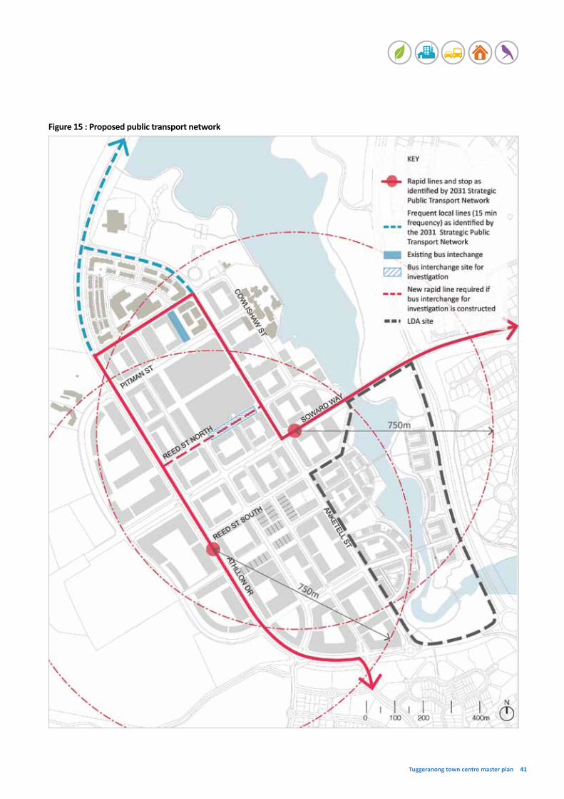
Tuggeranong town centre master plan 41
Figure 15 : Proposed public transport network

ACT Government | Environment and Sustainable Development Directorate 42
4.4 Pedestrian and cyclist network
Supports strategies 1 and 2.Awalkableandcyclablecommunityhasseveralingredients:
• easytofindyourway(legibleandwellconnected)
• a pleasant journey (high quality design public domain andshopfronts)
• feelssafetowalkbothdayandnight(goodlightingandpassivesurveillancefromnearbyresidential)
• accessibletoeveryone(young,old,disabledandmumswith prams), and
• allowsfasttravel(shortanddirectroutes).
Although Tuggeranong town centre has a permeable grid street layout, the Analysis summary report March 2011 identifiedthatthecentrehaspoorconnectivityandlegibilityofpedestrianandcyclenetworks.Thisismainlyduetohighspeed roads which act as barriers to pedestrian and cyclist movementandstreetswhicharedifficulttocrossduetoroadwidthandlimitedcrossingfacilities.
Toaddresstheaboveissuesandpromotewalkingandcycling,acontinuousnetworkforpedestriansandcyclistsshouldbeprovided.Thiscouldbeachievedby:
• increasingthenumberofmid-blockconnections. Figure16showshowblocksover200minlengthcouldbebrokenuptoimproveconnectionsforpedestriansandcyclists;breakingupblocksmaximisesthenumberofpotentialjourneys(shortcuts)betweendestinations.
• increasingthenumberofforeshoreconnectionsandthequalityoftheconnectionstothelake.
• providingconnectionsthroughopenspaces.Theproposedopenspacenetwork(seesection4.8)introduces new public open spaces which also act as new pedestrianandcyclistconnections.
• increasingsafetyandamenity.Theproposedbuildingsaroundthetowncentrearetohavezerosetbacks,withmanyhavingshopfrontoractivefrontagetreatment(seelanduse,insection4.1andactivefrontagessection4.7)andresidentialontop.Thesetypesofbuildingsprovidepassivesurveillanceforpedestriansandcyclistsbothdayand night.
• providingadditionaldedicatedcyclelanes.ThesewillbeprovidedalongSowardWayandAthllonDrivetominimiseconflictsbetweenparking,cars,busesandcyclists. It is proposed that cycle lanes should sit next to thepedestrianpathbeforecarparking.
• ensuringanyprecinctcodecreatedforthecentrerequiresretailandofficeprovideendoftripfacilitiesforpedestrians and cyclists such as bicycle parking, showers andchangefacilities.
Dedicated cyclist and pedestrian facilities minimise conflict between parking, cars, buses and cyclists and pedestrians
Mixed use development provides passive surveillance for pedestrians/cyclists day and night
Existing Tuggeranong foreshore and cycling facilities

Tuggeranong town centre master plan 43
Figure 16: Proposed cyclist network and main pedestrian routes

ACT Government | Environment and Sustainable Development Directorate 44
4.5 Street hierarchy
Supports strategies 2 and 3.Streethierarchyisanimportantelementtotheoverallcharacterofaplace.Agoodstreethierarchycanencouragepeople to walk, to cycle and to linger.
Streethierarchyisbasedontwofactors,‘capacity’and‘character’.
CapacityCapacityisdeterminedbymovementtypesandnumber(thenumberofcar,trucks,buses,pedestrians,bikes)andthestreet’sfunctions(highway,residentialstreet,retailstreet).
CharacterThe elements that contribute to a street character are:• thewidthofthefootpath
• treeplanting
• thenumberoftrafficlanes
• car parking arrangement (parallel, right angle, medium strip etc)
• cycle ways
• building height
• streetfurniture,and
• streetlighting.
Theproposedtypesofstreetasshowninfigure17are:• Boulevard1(AthllonDrive)
• Boulevard2(SowardWay)
• Main Street 1 (Anketell Street North)
• Main Street 2 (Anketell Street South)
• CommercialStreet1–ReedStreetNorth
• CommercialStreet2–PitmanStreet,ReedStreetSouth
• Drive1–CowlishawStreet
• Drive2–RowlandReesCrescent
• LocalStreet1–Existing(JoselandStreet)
• LocalStreet2–New
Local Street character.
Main Street character: mixed use building with active frontages at ground level, lined with street trees, street design to prioritise pedestrian and integration with public transport.

Tuggeranong town centre master plan 45
Figure 17: Proposed street hierarchy

ACT Government | Environment and Sustainable Development Directorate 46
Capacity Mediumvolume
Trafficflow Twolaneseachway/cyclewaybothway
Land use Officebuildingonthewesternsideandmixedusebuildingontheeasternside
Building height 8-9 storeys
Building setback 0 metre
Landscape character Continuousregularspacing,treetype(TBC),height(TBC),planterwidth(TBC)
WaterSensitiveUrbanDesign Swale in the middle - Pedestrians and cyclists need to be able to cross
Pedestrian PedestrianParking ParkingRoad Swale RoadCycle
44mTotalReserve
office
office
office
residential
office
Boulevard 1 - Athllon DriveThedesiredcharacterofAthllonDriveisurban,withtallerbuildingsonbothsideswithnofrontsetbacks,generouslandscapingwithamediantodividetraffic,widefootpathsandparkingonbothsides.
Boulevardcharacter:wideroadreservewithsimilarheightbuildingonbothsidesofthestreet.
basementcar parking
basementcar parking

Tuggeranong town centre master plan 47
Capacity MediumvolumeTrafficflow Twolaneseachway/cyclewaybothways,parkingonbothsidesLand use Mixedusedevelopment,withretailgenerallyatthegroundlevel,commercialofficeonthe
secondtothirdlevel,andresidentialaboveBuilding height 8-9 storeysBuilding setback 0 metreLandscape character Continuousregularspacing,treetype(TBC),height(TBC),planterwidth(TBC).Thetree
plantingshouldreinforcethestrongaxisviewtothemountainrangetothewestWaterSensitiveUrbanDesign Swale in the middle - Pedestrians and cyclists need to be able to cross
Pedestrian PedestrianRoad Swale
46mTotalReserve
RoadCycle Cycle
residential
office office
office retail
residential
basementcar parking
Boulevard 2 - Soward WayThedesiredcharacterofSowardWayisurban,withtallerbuildingsonbothsideswithnofrontsetbacks,generouslandscapingwithamediantodividetraffic,widefootpathsandparkingonbothsides.Thereistobemoreretailactivitiesonthegroundlevelandacyclelanenexttootherpedestrianpathbeforethecarparking.
Boulevardcharacter:linedwithtreeplantinginthemedian.

ACT Government | Environment and Sustainable Development Directorate 48
Capacity LowvolumeTrafficflow One lane each way, parking on both sidesLand use Mixedusedevelopmentwithretail,restaurantsandcommunityfacilitiesatthegroundlevelBuilding height 6-7 storeys on the western side (Hyperdome side) which then steps down to 3-4 storeys
towardstheforeshoreareaBuilding setback 0 metreLandscape character Continuousregularspacing,treetype(TBC),height(TBC),planterwidth(TBC).
Deciduoustreesmaybesuitable.Inaddition,treeplantingshouldreinforcethe strongaxisviewtoUrambiHills
Main Street 1 - Anketell Street NorthThedesiredcharacterofAnketellStreetNorthisurban,vibrantindayornight,‘eatstreetcharacter’with outdoor dining.
Shared Pedestrian Shared PedestrianParking ParkingRoad
32mTotalReserve
office
mixofuses/residentialfocus
retail, restaurant, communityfacilities
retail, restaurant, communityfacilities
mixofuses
basement car parking
Main Street 1 character: outdoor dining on wide footpathaddslifetostreetdayandnight.

Tuggeranong town centre master plan 49
Capacity LowvolumeTrafficflow Onewaybothways,parkingonbothsides,onroadcyclepathisprovidedLand use Mixedusedevelopment,withresidentialontheGreenwayside(easternside)andtime,
workandserviceonthewesternsideBuilding height Generally 6 storeys on the eastern side but in some instances allow buildings up to 12
storeys (in accordance with the LDA Greenway Master Plan). Between 3 and 6 storeys on the westernsideofAnketellStreetSouth.
Building setback 0 metre
Landscape character Continuousregularspacing,treetype(TBC),height(TBC),planterwidth(TBC).Streettreeswillprovidepedestriancomfortandencouragewalkingandcycling
Pedestrian PedestrianRoad
32mTotalReserve
Cycle CycleParking Parking
office
residential mixofuses
parking
Main Street 2 - Anketell Street SouthSimilartoAnketellStreetNorth,AnketellStreetSouthwillcontinueasanurban,pedestrianfriendlystreetwhichismoreresidentialandofficefocusedandhaslessofafocuson‘eatstreet’character.Itismorearesidentialfocusedurbanarea.
Main Street 2 character:tall,formalisedstreettreesframetheview,alsoprovideamenitytopedestrians/cyclists.

ACT Government | Environment and Sustainable Development Directorate 50
Capacity LowvolumeTrafficflow Onelaneeachway,parkingonbothsides,andbuspulloverbaysLand use Mixedusedevelopment,withfocusongroundfloorretailBuilding height 6-7 storeys on both sidesBuilding setback 0 metreLandscape character Highqualitypavement,streetfurnitureforweatherprotection,streetlighting
Commercial Street 1 - Reed Street North ReedStreetNorthisthestreetrecommendedtoaccommodatetheproposedrelocationofthebusinterchangefromPitmanStreet.
Pedestrian PedestrianRoad
32mTotalReserve
Bus Interchange Bus Interchange
retail
basement car parking
mixofusesmixofuses
retail
Commercial Street 1character:designprioritisespublictransport, cyclists and pedestrians.

Tuggeranong town centre master plan 51
Capacity LowvolumeTrafficflow One lane each way, parking on both sidesLand use: Mixedusedevelopment,withfocusongroundfloorretail
Building height 6-7 storeys on north side and 4-5 on south sideStreet setback 0 metreLandscape character Continuousregularspacing,treetype(TBC),height(TBC),planterwidth(TBC).Streettrees
willprovidepedestriancomfortandencouragewalking
Commercial Street 2 - Reed Street South Urban,withretailorotheractivefrontagetreatmentatthegroundlevel.
PedestrianParking ParkingRoad
32mTotalReserve
basement car parking
mixofuses
workshop/
artiststudio/retail
officemixofuses
Pedestrian
Commercial Street 2character:anactivefrontageandlinedstreettrees.

ACT Government | Environment and Sustainable Development Directorate 52
Capacity LowvolumeTrafficflow One lane each way, parking on both sidesLand use: Mixedusedevelopment,withfocusongroundfloorretailandcommunityfacilitiesBuilding height Variesfrom2to5storeysBuilding setback 0 metreLandscape character Onesideregularplantingtheothersidewilldependonuses,parkorbuildings.Treetype
(TBC), tree height (TBC)
Shared Pedestrian Shared PedestrianParking ParkingRoad
32mTotalReserve
mixofuses
basement car parking
officeorcommunity
facilities
mixofuses
retail/restaurants
Drive 1 - Cowlishaw Street Alocalslowmovementstreetlocatedbetweenanurbanareaandthelake.Couldbepark,waterfrontornaturalreserve.Onesideofthedrivehasurbancharacterasastreetwithfootpathandbuildings,buttheothersidedirectlyfrontsthelakeinplaces.
Drive 1character:3-4storeymixedusedevelopmentwithgreenroof.

Tuggeranong town centre master plan 53
Capacity LowvolumeTrafficflow One lane each way, parking on one sideLand use: MainlyresidentialBuilding height Generally6-7storeysontheeasternsideandamaximumof2storeysonthewesternsideBuilding setback 0 metreLandscape character Onesidewillhaveregularplantingandthewestsidewillhavescatteredplanting.
Tree type (TBC), tree height (TBC)
Existingvegetation
P = Pedestrian
Shared PedestrianRoad
31mTotalReserve
residential
potentiallive/work
Drive 2 - Rowland Rees CrescentAlocalslowmovementstreetthatactsastheboundarybetweentheurbancentreandthe bush to the west.
Drive 2character:highrisedevelopmentoverlookstogreenspace.
P

ACT Government | Environment and Sustainable Development Directorate 54
Pedestrian Parking Parking PedestrianRoad24mTotalReserve
Local Street 1 - Existing (Joseland Street)Alocal,slowmovementstreet.Streetsprovidefrontageformixedusebuildings,services,ecoindustrialbuildingsorterracetypebuildings.Urbanincharacter:widefootpaths,parallelparking.Charactermayvaryinresponsetoitsuses.
Capacity LowvolumeTrafficflow One lane each way, parking on both sidesLand use: MixedusedevelopmentBuilding height 3-5 storeys Street setback 0 metreLandscape character Both sides with regular trees. Tree type (TBC), tree height (TBC)
Local Street 1character:linedtreesprovidesenseofenclosure.Mixedusebuildingprovidessurveillancedayandnight.

Tuggeranong town centre master plan 55
Capacity LowvolumeTrafficflow One lane each way, allow parking in one laneLand use: Mixedusedevelopment,potentialretailatgroundlevelBuilding height 6-9 storeys on both sidesStreet setback 0 metreLandscape character Tree type (TBC), tree height (TBC)
Pedestrian PedestrianParking Road
15mTotalReserve
basement car parking
mixofuses mixofuses
Local Street 2 - NewAlocal,slowmovementstreet.Urbanincharacter:widefootpaths,parallelparking,narrowlanes.Charactermayvaryinresponsetoitsuses.Canalsobeusedasaservicelane.
Local Street 2character:differentbuilding types (depends on the uses) , low in scale, lined with streettreestogiveanurbancharacter to the area.

ACT Government | Environment and Sustainable Development Directorate 56
4.6 Building heights
Supports strategies 1 and 3.
Building height responds to:• street hierarchy
• viewstothelakeandsurroundingmountains,and
• protectingsolaraccesstopublicspaces.
Inlightofthesethreefactors,thefollowingheightsarerecommendedforthetowncentre(seefigures18):• lower buildings 16-19.5m (approximately 4-5 storeys)
arelocatedalongtheforeshoreinordertoprotectthewaterfrontfromthevisualimpactofbuildingheight
• generally medium height buildings 19.5-23m (approximately 5-7 storeys) are located along the local streets(seesection4.2fordetailsonstreethierarchy)
• taller buildings 23-30m (approximately 7-9 storeys) are locatedalongthemajorboulevards,i.e.AthllonDriveandSowardWay(seesection4.5fordetailsonstreethierarchy), and
• theservicetradesareaatthesouth-easternendofthecentreisrecommendedtohaveamaximumbuildingheightof12m(3storeys).Thisheightisrecommendedsothepotentialforhigherleveldevelopmentovertakingtheservicetradesfunctionsisreduced.
Theheightsproposedherehavebeentestedthroughapreliminarystudyoftheimpactofbuildingheightsonpublicspaces,i.e.bulkandscale,solaraccess,viewsetc.
However,moredetailedstudieswillberequiredpriortocompletionoftheprecinctcodeandfornewdevelopments.These detailed studies will include:• avisualimpactstatementforbuildingsthatexceed23m
in height
• aphotomontagewhichdeterminestheimpactoftheproposedbuildingonviewsfromtheoppositesideofthelake to the surrounding mountains, and
• asolaraccessstudytoensureproposeddevelopmentwouldnotsignificantlyreducethewintersolaraccesstopublicspacesorsurroundingresidentialdevelopment.
Heightsareexpressedinmetresandstoreys.Differentuseshavevariousfloortoceilingheights(e.g.thefloortoceilingheightforretailoradaptiveusesatthegroundlevelwouldbehigherthanresidentialuses).
Exampleofterracetypedevelopmentwhichcouldbefoundinareaswhereheightsof3-4storeysareappropriate

Tuggeranong town centre master plan 57
Figure 18: Proposed building heights

ACT Government | Environment and Sustainable Development Directorate 58
4.7 Active frontages
Supports strategies 2 and 3.Figure19showswhereactivationofstreetswillberequiredin the centre.
Proposedactivefrontages:
• Anketell Street (North)
• AnketellStreet(South)ifmarketdemands
• New town square
• CowlishawStreet(partof)
• Foreshore–buildingfrontingthelakeshoreopenspace
• ReedStreetNorthandPitmanStreet–Hyperdomefrontage
• Soward Way and its side streets
Thismasterplanidentifiestwotypesofactivefrontages.
Active frontage (core)Coreactivefrontages:
• willnotbefrontedatanypointbylongblankwalls
• willbefrontedbybuildingswhichareorientedtowardsthe street
• willhavelargelytransparentfrontages
• willprimarilybefrontedbyusessuchasshops,restaurants,cafes,communityfacilitiesandotheruseswhichgeneratemuchactivity,and
• willgenerallynotbefrontedbyresidentialbuildings.
Active frontage (secondary)Secondaryactivefrontages:
• donotneedtobefrontedbyshops/restaurants/cafes
• willbefrontedbybuildingswhichareorientedtowardsthestreetsothatasenseof‘eyesonthestreet’iscreated
• willbefrontedbybuildingsthatareabletobeadaptedatthegroundfloorforanewuseasmarketdemandchanges i.e. when constructed buildings will be required tohaveafloortoceilingheightthatissuitableforcommercial use, and
• canbefrontedbyresidentialbuildings.Theseresidentialbuildingswillneedtohavemanyindividualentriesfromstreetlevel,willhaveminimalsetbacksandwillallowforvisualinteractionandpassivesurveillanceofthestreet.
Outdoordiningcontributestostreetlifedayandnight

Tuggeranong town centre master plan 59
Figure 19: Proposed active frontages

ACT Government | Environment and Sustainable Development Directorate 60
4.8 Natural features and public open space
Supports strategies 1 and 5.Tuggeranong town centre is surrounded by mountains and thelake.Theriver,bush,lakeandmountainscontributetothecentre’suniquecharacter.Thesefeaturesshouldbeseenaspartoftheopenspacenetwork(physicallyaswellasvisually).TheexistingopenspaceassetsforTuggeranong(thetownsquare,theforeshoreandTuggeranongTownPark)havebeenunder-utilisedduetopoorqualityandaccessibility.Itisimportanttoimprovethequalityandaccessibilityoftheseassetsandconnectthembacktotheoverallopenspacesystem.
WiththeproposedpopulationincreaserecommendedinthetowncentrebythismasterplanandLDA’sGreenwayMasterPlan (approximately 7800 dwellings), there is an opportunity toprovidemore‘breathingspace’andamenityforthefuturepopulation.Newpocketparksareproposedforthetowncentreinordertoprovidemorerecreationalopportunitiestothefuturepopulation.Thesenewopenspacesvaryinsizeandarediverseinfunction.Allthelocationsofthenewopenspaceshouldconsiderrelationshiptotheoverallpedestrianprioritisedenvironmentandshouldintegratewithsurrounding buildings.
Figure20illustratesindicativelocationoftheexistingandproposed open space network. It is recommended that a publicdomainmanualwithdetaileddesignprinciplesforeachtypeofopenspacebeproduced.
ForeshoreProvidecontinuousaccesstothelakeforeshore.Thisaccesswillgopastparkland,urbanareas,theschoolandresidential.Amoredetailedplanforthislakefrontaccessshouldbedevelopedtoidentifywheredifferentlandscapetreatmentsareappropriateaspeoplemovearoundthelake.
Tuggeranong Town ParkIncrease accessibility to this open space by requiring a mixed usedevelopmentontheexistingcarparktothesouth(Section18)toprovidepassivesurveillanceandgroundlevelactivefrontagethatactstodrawpeoplefromthetowncentre to the park.
New town squareThetownsquarewillbedefinedbybuildingswithactivefrontages(suchasalibrary,theatre,restaurantsandshops).Usesshouldattractbothdayandnightactivity.ThenewtownsquareshouldbeopenandinvitingandthedesignshouldaddressthelevelchangesthatoccurbetweenAnketell Street and the lake (i.e. terrace style garden).
Pocket parksThese small public open spaces will either:• actasbreakoutspacesfornearbyresidentsor
employees,and/or
• belocatedwithinthepedestriannetworktoprovidewayfindingthroughthecentreandamenitytothearea.
Ideally these parks will be orientated to the north and havetwofrontagesopentotheroad,withonesideasapedestrian pathway. To reduce maintenance costs these parkswillbedesignedsoinfrastructurerequirementsaresimplei.e.seatingandinformalshadytrees.Thosepocketparks, which will sit within the pedestrian network, will use materials which can handle the wear and tear which comes fromhighlevelsoffoottraffic.
Where possible pocket parks will be created, owned and managedbyprivatelessees.
Attached green spacesDefinedbyorattachedtoonesideofbuildings,attachedgreen spaces are located within the pedestrian network. Theyprovidewayfindingandamenitytothearea.Theycanincludeformalorinformalplanting,pedestrianpavement,andinformalseating.Theywillbecomea‘breathingspace’forpeoplewhoworkorlivearoundthearea.
Publicsquareisframedbyactivefrontagesandactivities.

Tuggeranong town centre master plan 61
Figure 20: Proposed public open space

ACT Government | Environment and Sustainable Development Directorate 62
4.9 Car parking and loading
Supports strategies 2 and 3.Sufficientparkingisimportantforthesuccessfuloperationofthecentre.However,parkingshouldbeconsideredsopedestriansaregivenpriority.Thereisevidencethatthelocationofcarparkingisscatteredandcreatesbarriersforpedestrians throughout the centre.
This master plan recommends that parking and loading need tomakeacontributiontoprioritisingpedestriansinthetowncentre.Theproposedmeasurestoachievethisare:
• undergroundorrooftopparkingforlargedevelopments
• parkingforresidents,tenantsandpatronsprovided
• short-term parking on streets as it will increase the movementandviabilityofthestreetandslowdowntraffic
• long-termparkingattheperipheryofthetowncentre,and
• proposed loading areas designed to minimise the conflictsbetweencar/truckandpedestrian/cyclist.
Section18(tothesouthofthetownparkandwestofLakeTuggeranongCollege)ofthecentreiscurrentlyanACTGovernmentownedsurfacecarpark.ThiscarparkisavailabletothegeneralpublicbutalsohasanumberofcarparksdesignatedtostudentsofLakeTuggeranongCollege.ThismasterplandoesrecommendthateventuallythissectionbereleasedbytheACTGovernmentforthepurposesofamixedusedevelopment.Whenthissectionisreleased,anydevelopmentonthesitewillberequiredto:
• replaceexistingcarparkingspaces
• provideparkingspacesneededforthenewdevelopment,and
• ensurethenumberofcarparkingspaceswhicharecurrently designated to Lake Tuggeranong College be maintained.
On-streetparkingwithformalisedstreettreeonthesideandoverlookedbyresidentialdevelopment.

Tuggeranong town centre master plan 63
Figure 21: Proposed car parking and loading

ACT Government | Environment and Sustainable Development Directorate 64
4.10 Food production
Supports strategy 5.Thefollowingtypesoffoodproductioncouldbeappliedtothe Tuggeranong town centre:
• Large community gardens
• Rooftopgarden
• Communal garden
• Balcony gardens
LargecommunitygardenswouldrequiresomeinvestmentfromtheACTGovernmentbutwouldlargelyberunbycommunity groups.
Rooftopgardensandcommunalgardenswouldmostlybeincorporatedintoprivatedevelopments.Itisnotpossibleordesirabletomakethesefoodproductiontypologiescompulsoryastheyrequirecommitmentandinvestmentfromthebuildingownersandtenants.However,itispossibletorequireintheprecinctcodethatbalconiesofnew apartments are large enough to accommodate some foodproduction.Though,onceagain,thiswilldependontheowners/tenantsoftheindividualapartmentandtheirpersonalinterestinfoodproduction.
Large community gardenThese gardens are to be located outside the centre and could be between 2000m2 and 5,000m2. Community gardens are runbycommunitygroups.Producewouldbeforprivateconsumptiononlyandwouldnotbeavailableforsaletomembersofthepublicexceptforraisingfundstosupportthe community group. When it comes to planning these gardens in more detail, should a group be interested, it will be necessary to ensure access to a water mains.
Thistypeofgardencouldbelocated:• onthewesternedgeofthecentreornearthe
MurrumbidgeeRiver(5000m2)subjecttocompatibilitywiththeReservePlanofManagement,or
• ontheeasternsideofthecentreatthesouthernendofthelakeatoneoftwopossiblelocations(2000m2)(refertofigure22).
Roof top gardenThesetypesofgardensshouldbeintegratedintothebuiltform.Producecanfeedthepeoplewholiveinthebuilding.
Communal gardenSimilartorooftopgardens,communalgardensgrowfruitandvegetablesatthepodiumlevelofthebuildingorcourtyard.Produceissharedbypeoplewholiveinthatbuilding.Thebodycorporatemaybethemanagerforthistypeofgarden.
Balcony gardensBalconiesofapartmentsmaybebigenoughtoaccommodateabasicfoodgardenwhichcanservehousehold needs.
Rooftopgarden.
Exampleofturningcommunalareatofoodproductiongarden,withresidentialoverlookingtothearea.

Tuggeranong town centre master plan 65
Figure 22: Proposed food production

Kingstonforeshoredevelopment,anexampleofthetypeofdevelopmentthatcouldoccurinthetowncentre.

Tuggeranong town centre master plan 67
Implementation
5 Implementation
Thissectionofthereportlooksathowthismasterplancanbe implemented including:
• whattoolsareavailabletoimplementthemasterplan
• possiblesequencingofdevelopmentovertimeasthemaster plan is realised
• potentialcatalystprojects,and
• thenextstepstobetakentostartimplementationofthemaster plan.
Tools to implement the master planTherearethreekeytoolsthatwillplayaroleinrealisationofthemasterplan.Thesearedetailedbelowandshowngraphicallyinfigure23.
1. Territory Plan variation – precinct codeDevelopmentintheACTisregulatedthroughtheTerritoryPlan,whichshowswheredevelopmentcangoandwhattypeofdevelopmentweandourneighbourscanbuild.TheTerritory Plan can be changed through a process called a TerritoryPlanvariation.Thisisastatutoryprocesswhichincludesconsultationand,whencomplete,canaltertherangeoflandusespermissibleonasiteand/orchangesthedevelopmentcontrolsapplicabletoasite.Area(orprecinct)specificchangescanbeintroducedintotheTerritoryPlanthrough a precinct code.
ItisproposedtoestablishaprecinctcodefortheTuggeranong town centre so the planning and design strategiesandelementsofthemasterplancanbeachieved.
2. Sale of Territory owned landSomeTerritoryownedlandhasbeenidentifiedbythismasterplanasappropriatefortheTerritorytosell.Thislandcanbereleasedtointerestedpartiesthroughanauction,tender/expressionofinterestordirectsaleprocess.Adeedofagreementwillbeplacedonthelandtobereleasedwhichmayincludeoffsiteworksrequirementssuchaspavingandlandscapingthatcontributestothepublicrealm,and replacement car parking.
3. Capital worksImprovementstothepublicrealmorcommunityassetsandinfrastructurecanbeimplementedthroughcapitalworksundertakenbytheACTGovernment.Thiswillinvolvevariousgovernmentagenciesandfundingthroughfuturegovernmentbudgets.
Other implementation factors Development applicationIt will be up to the lessees and the business community totakeadvantageofmanyoftheopportunitiesidentifiedinthemasterplan.ThiswilloftenrequirelodgementofadevelopmentapplicationtoassesscomplianceagainsttheTerritoryPlananditsrelevantprecinctcode.Manyoftheproposedchangesinthismasterplanareonexistingdevelopedsites,thereforeitislikelytotakeanumberofyearsbeforesomeaspectsofthemasterplanarerealised.
Ongoing community engagementThecommunitywillbeabletobeinvolvedasimplementationofthemasterplanoccurs;eitherthroughnotificationonvariationstotheTerritoryPlan(suchastheintroductionoftheprecinctcode)ornotificationondevelopmentapplicationsastheyarelodged.
Creation of precinct
code
Territory Planvariation
to include precinct code
Territory Plan
Endorsed master plan
Public notification
Public notification
Figure 23: Tools to implement the master plan.
Budget bids for capital
works
Capital works funding
allocated
Capital works projects
completed
Deed of agreement prepared
Territory owned land
sold
Development application
lodged
Development application
decided
Development can commence if development
application is approved

ACT Government | Environment and Sustainable Development Directorate 68
5.1 Potential timing
Itisimportanttorecognisethatthetowncentrewilldevelopandredevelopovertime.Theobjectivesofthismasterplanaretoguidethisdevelopmentandredevelopmentsoitcontributestotheachievementofthevisionandoutcomes.Theimagesoverthenexttwopagesshowhowthecentremayevolveoverthenext30years(thelifeofthismasterplan).Theseimagesareonlyindicativeandhavebeendevelopedbasedonthefollowingassumptions:
• siteswhichhaverecentlybeendevelopedorhadadevelopmentapplicationapprovedrecentlywillnotchange in the next 30 years
• Territory owned land will be released in either developmentsequence1or2shownbelow,and
• largebuildingsareasignificantinvestmentthuswill notberedevelopedforamuchlongerperiodthansmaller buildings.
Indicative development sequence 1
Land release opportunitiesReleaseanddevelopthesitetotheeastofAnketellStreetopposite Bunnings. This Territory owned site has been subjecttoamasterplanbytheLDAtoallowforitsrelease.Theproposeddevelopmentwillincreasethetowncentre’spopulationandbeanimportantcatalystprojectforchangeinthecentre.(seesection6.0ofthisreportformoredetailon catalyst projects).
Development and redevelopment opportunitiesRedevelopmentofsections18and19andpartsofsection54.TheseactionswillimprovethequalityoftheforeshoreareaneartheLakeTuggeranongCollegeandimprovetheconnectionfromAnketellStreetdowntothelake.Thiswouldbeanimportantcatalystprojectforthecentreasitprovidestheopportunitytocreateanattractivefeatureforthecentre.Thepotentialforpublic/privatepartnershipsneedstobeexploredasthesesectionshaveamixofownersincludingtheTerritory.Seesection6.0ofthisreportformoredetailson how this catalyst project can be implemented.
Public domain improvement Newpedestriancrossings,treeplanting,sharedzonepavementandanewcyclingroutewillberequiredaspartofredevelopmentonSections18and19.
Indicative development sequence 2
Development and redevelopment opportunitiesProvideincentivesforredevelopmentalongSowardWayin accordance with the master plan by increasing allowable heightsandfloorspaceonsectionsfacingthestreet.
Asselect‘superblocks’redevelop,theintroductionoflanewaysormid-blocklinkstoincreasethepermeabilityofthecentreforpedestrianandcyclistswillberequired.
Public domain improvementAsSowardWayredevelops,exploreopportunitiesforcapitalworksprojectstoimprovethestreetscape.

Tuggeranong town centre master plan 69
Indicative development sequence 3
Land release opportunitiesTherearetwoparcelsofTerritoryownedlandatthewesternendoftheHyperdome.Theseprovideanopportunitytotransformthetraditional‘superblock’shoppingcentredevelopmentbycreatingnewstreets/publicaccess,breakinguptheblockoflandintoafinergrainandcreatingamorepermeable shopping centre.
Public domain improvementA new street is introduced to accommodate access to new developmentadjoiningthewesternsideoftheHyperdome.
Indicative development sequence 4
Land release opportunitiesSitesalongthewesternedgeofthecentreareownedbyGovernmentagenciesincludingtheCommonwealth.Whethersiteswillbedevelopedornotdependsonmanyfactors.Theymayormaynotredevelopduringthelifeofthemaster plan.
Development and redevelopment opportunitiesProvideinitiativestotheHyperdometoredevelopinaccordance with the master plan by increasing allowable height,floorspaceandintroducingresidentialmixed usedevelopment.
Public domain improvementToaccommodatethedemandsofthenewresidentsexploreopportunitiesforcapitalworksto:
• introduce new pockets parks, and
• improvestreetscapes.

ACT Government | Environment and Sustainable Development Directorate 70
6 Catalyst projects
Catalystprojectscanplayakeyroleintherealisationofthemasterplanvision.Theycanreinvigoratepartsofthecentreandtriggerfurtherrevitalisationbyattractinginvestmentintothearea,includingnewbusinessesanddevelopment.
Thecatalystprojectsoutlinedinthisreportwereidentifiedbecause:
• they are situated on a site which presents an immediate opportunityforredevelopmentbecauseitisTerritoryownedlandortherearefewprivatelesseesinvolved, and/or
• theyaresituatedsotheyhavethepotentialtobeacatalystforchangeforthecentreandcantriggertherevitalisationoftheTuggeranongtowncentreandimplementationofthemasterplanvision.
Catalyst 1 - Greenway Master PlanPlanningforthereleaseofthissiteisalreadyunderwayandadraftmasterplanhasbeenproducedbyLDA(seeAttachmentA).Itwillmostlikelybethefirstcatalystprojectto be realised. ESDD has been working closely with the LDA duringthecourseoftheTuggeranongtowncentremasterplan project and the Greenway Master Plan project. Release anddevelopmentofthislandwillsupportachievementofmanyofthestrategiessetoutbythismasterplanincludingincreasingresidences(whichwillincreaseeconomicviabilityofthecentreduetoincreasedpopulation).
Proposed land uses:Residential.
Ownership:Territory owned unleased land.
Planning and design strategies:TheLDAhasestablishedaseriesofdesignprinciplesspecificallyforthissite.Detailsoftheseandotheraspectsoftheprojectcanbefoundatwww.lda.act.gov.au
Implementation:Will be released by the LDA with requirements as to the type andformofthedevelopmentallowed.
Catalyst 2 - Foreshore Duringcommunityconsultationitwasnotedthelakeis not used as much as it could be and the centre does notconnecttoitwell.Inparticulartheretailheartofthecentre, near Anketell Street and the town square, do not makeastrongconnectiontothelakeeitherphysicallyorvisually.Inaddition,usesalongsidethelake,suchasfastfoodrestaurants,donotattractpeopletousethisforeshorearea.Theoutcome‘acentreconnectedtolandscape’emphasisestheimportanceofcapitalisingonwhatmakesthiscentreuniquebyprovidingandimprovingconnectionstosurroundingnaturalassetssuchasthelake.Ultimatelytheforeshoreareahasthepotentialtobeanactiveandvibrantpublic space which embraces the lake.
Proposed land uses:Groundfloorretailandentertainmentusescouldfacethelakewithresidentialorahotelabove.Theseusesshouldbeabletobenefitfromexcellentsolarorientation.
Artist impression of Tuggeranong central.

Tuggeranong town centre master plan 71
Ownership:Governmentleasedland(theTuggeranongCommunityCentreandtheTuggeranongArtsCentre),privateleasedland(McDonalds and KFC) and Territory owned unleased land.
Planning and design strategies:Thiscatalystprojecthasthepotentialtorealisethefollowingstrategies:
• improvedconnectionstothenaturalenvironment (the lake)
• improvedwalkability(aroundthelake),and
• building heights that step down towards the lake but stillallowforenoughincreaseinbuildingheightstoprovideanincentivetoprivateleaseholderstoredeveloptheir land.
Implementation:Thiscatalystprojectwillrequirefurtherinvestigationand,duetolandownershippatterns,apublic/privatepartnershipwillbelikely.ThisareashouldbeconsideredaspartoftheplanningfortheTuggeranongcentralarea.
Catalyst 3 - Tuggeranong centralTuggeranongcentralwillbecometheactiveheartofthecentre.Itwillbeamixofcommunity,retail,entertainment,recreation,residentialandcommercialuses.AnketellStreetwillcontinueasastreetbuttrafficwillbeslowedbyintroducingmoreonstreetparkingandeventuallyincreasingthewidthsoffootpathsontheeasternside.Theconnectiontothelakewillbeimprovedbyopeningupthetownsquare.Achievingthismayrequireprivateandpublicpartnerships.TheintentistoincreasevisibilityofthelakefromAnketellStreet.
Proposed land uses:Groundfloorretailandentertainmentcouldfacethelakewitharesidentialorhotellocatedabove.Theseusesshouldbenefitfromsolarorientation.
Ownership:Governmentleasedland(TuggeranongHealthCentre),privateleasedland(i.e.theHyperdome)andTerritoryownedunleasedland(surfacecarparksandpublicopenspace).
Planning and design strategies:Thekeystrategiestobeachievedthroughthiscatalystproject will be to:
• provideconnectionstothenaturalenvironment(thelake), and
• activatestreetsandpublicplaces.
Implementation:Thiscatalystprojectwillrequirefurtherinvestigationand,duetolandownershippatterns,establishmentofapublic/privatepartnershipwillbelikely.Thisareashouldbeconsideredaspartofplanningfortheforeshorearea.

ACT Government | Environment and Sustainable Development Directorate 72
7. Conclusion
This Tuggeranong town centre master plan report has three sections:
• projectcontext–thissectionoutlinesdetailsoftheproject process, background research and analysis andcommunityconsultation,allofwhichhaveledtodevelopmentofthismasterplan.
• themasterplan–thissectionidentifiesavisionfortheTuggeranong town centre and outlines how this can be realisedasthecentredevelopsandredevelopsinthefuture.Itoutlinesfouroutcomesandsixsupportingplanninganddesignstrategies;additionaldesigndetailiscoveredbyaseriesofkeyactionsanddesignelements.
• implementation–thissectiondetailshowthemasterplancanbeimplemented,includingpotentialtimingandcatalyst projects.
7.1 Next steps
Next step towards implementationNowthemasterplanhasbeenendorsedbyGovernmentimplementationcancommenceasdescribedinsection5.0.Thekeyactionsneededtostartimplementationofthismaster plan are:
• prepareaprecinctcodewhichspecifieslanduse,heightanddesigndetailswhichwillencouragedevelopmentandredevelopmentandensureitachievestheprinciplesoutlined in the master plan and start the Territory Plan variationprocess
• investigateoptionsforprivate/publicpartnershipestablishmentandlandreleaseofTerritoryownedlandonSection19andlandaroundtheforeshore,and
• identifyandpreparecapitalworksproposalsforpublicrealmandinfrastructureimprovementsforconsiderationbygovernmentinsubsequentbudgets.


ACT Government | Environment and Sustainable Development Directorate 74
LDA’s draft Greenway Master Plan
Attachment A

Tuggeranong town centre master plan 75
