route book guide
DESCRIPTION
TRANSCRIPT

THE CZECH REPUBLIC ZŠ a MŠ Břeclav, Kupkova 1

Libro de rutas Healthy Mind in a Healthy Body
Wandering the Pálava Mountains
The Czech Republic Southern Moravia The Pálava Mountains
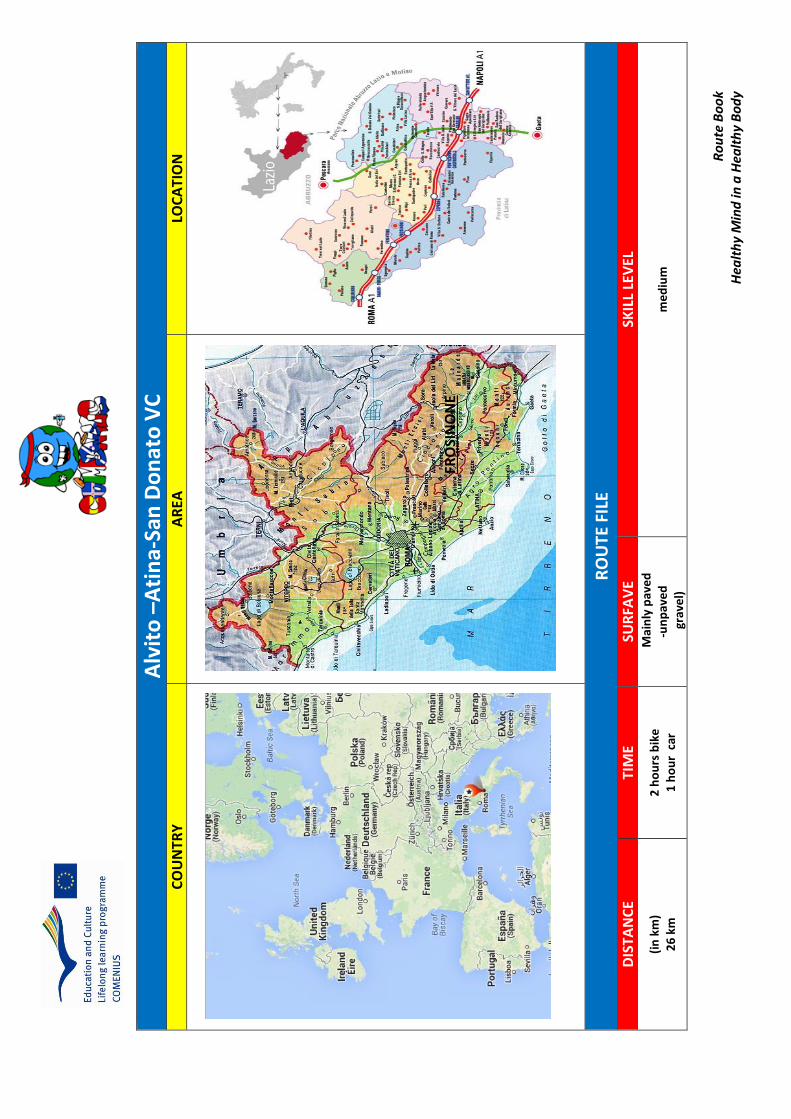
ROUTE FILE
DISTANCE TIME SURFACE SKILL LEVEL 10, 8 km 3 hours 40 mins Unpaved path medium
RO
UTE
START POINT
FULL
ITEN
ERA
Y
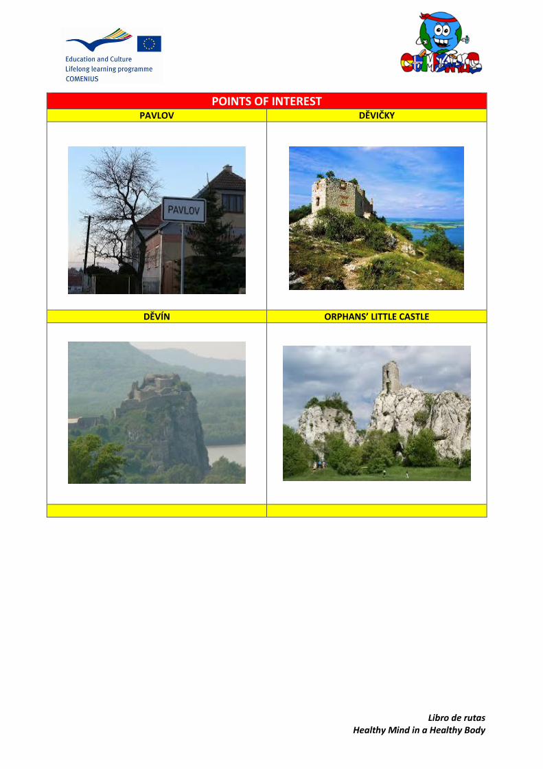
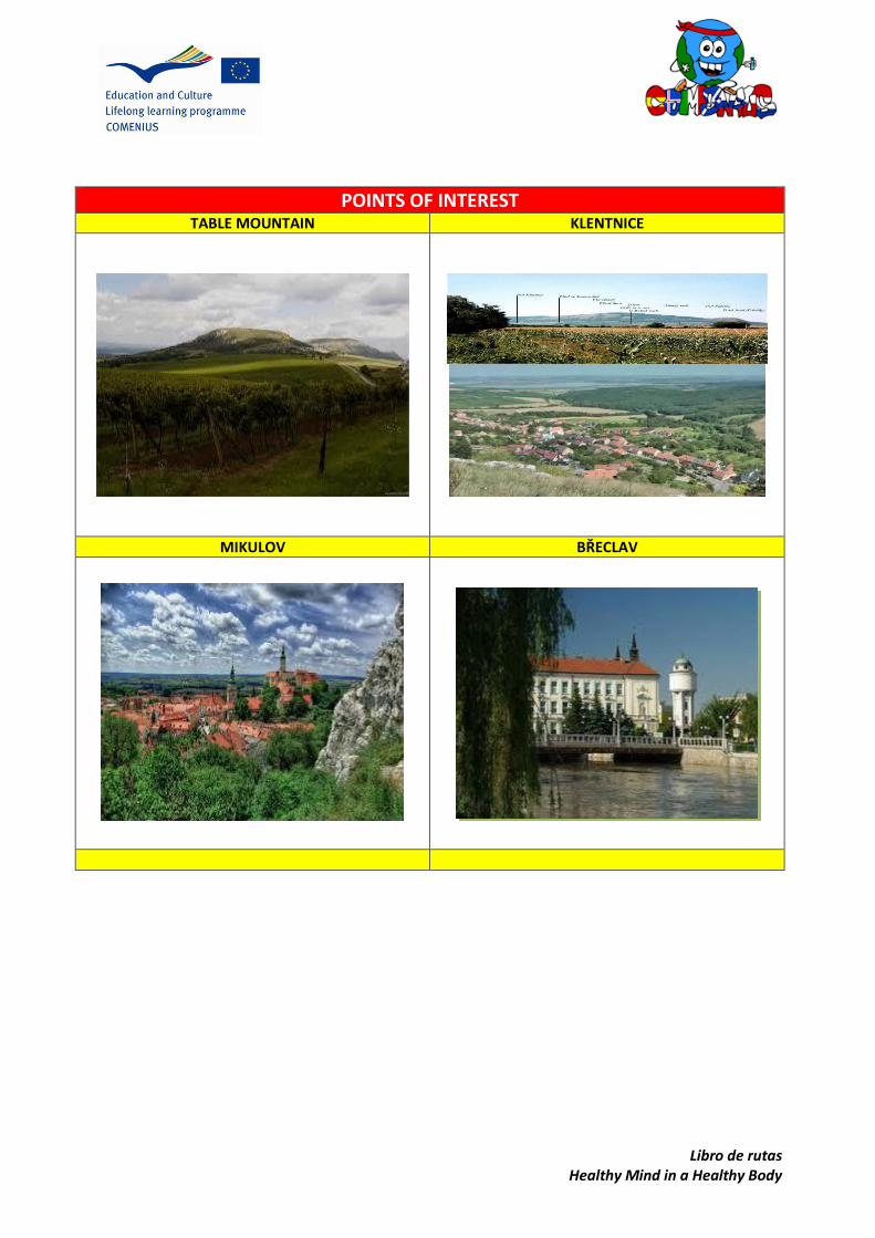
•Pavlov •Děvičky •Děvín •Sirotčí hrádek (Orphans’ Little Castle) •Klentnice •Stolová hora (Table mountain) •Mikulov
Pavlov FINISH POINT
Mikulov
MAP

Libro de rutas Healthy Mind in a Healthy Body
SUGGESTIONS AND OTHER INTERESTING DATA
•Meeting point: Breclav bus station, 7:45 am, 20 September 2013 •Sports clothes •Good trekking shoes •Rucksack with snack and water •Money for traveling
WALK DESCRIPTION
The Pálava Mountains are the lime stone mountains located in the Southern Moravia
spreading from the town Pavlov towards the town Mikulov and going futher to the
Austrian frontiers. The mountains are the protected area and belong to the biospheric
reservation Lower Moravia which is registered on UNESCO list. This place is the driest
and warmest place of the Czech republic with special species of plants, herbs and
animals, rich fields and wineyards all around.
Libro de rutas Healthy Mind in a Healthy Body
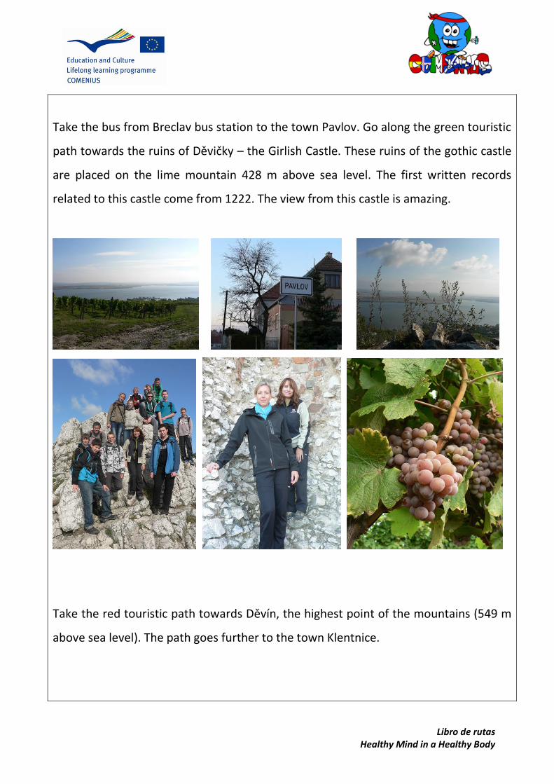
Take the bus from Breclav bus station to the town Pavlov. Go along the green touristic
path towards the ruins of Děvičky – the Girlish Castle. These ruins of the gothic castle
are placed on the lime mountain 428 m above sea level. The first written records
related to this castle come from 1222. The view from this castle is amazing.
Take the red touristic path towards Děvín, the highest point of the mountains (549 m
above sea level). The path goes further to the town Klentnice.
Libro de rutas Healthy Mind in a Healthy Body
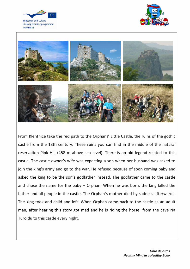
From Klentnice take the red path to the Orphans’ Little Castle, the ruins of the gothic
castle from the 13th century. These ruins you can find in the middle of the natural
reservation Pink Hill (458 m above sea level). There is an old legend related to this
castle. The castle owner’s wife was expecting a son when her husband was asked to
join the king’s army and go to the war. He refused because of soon coming baby and
asked the king to be the son’s godfather instead. The godfather came to the castle
and chose the name for the baby – Orphan. When he was born, the king killed the
father and all people in the castle. The Orphan’s mother died by sadness afterwards.
The king took and child and left. When Orphan came back to the castle as an adult
man, after hearing this story got mad and he is riding the horse from the cave Na
Turoldu to this castle every night.

Libro de rutas Healthy Mind in a Healthy Body
From the Orphan’s Little Castle take the path to the Table mountain. Its a flat
mountain with a very special and closed ecosystem, species of plants and animals very
different from neghbouring places.

Libro de rutas Healthy Mind in a Healthy Body
Take the path around the wineyeards to the town Mikulov.
Take the train from Mikulov train station back to Breclav.

Lib
ro d
e ru
tas
Hea
lth
y M
ind
in a
Hea
lth
y B
od
y
PO
INTS
OF
INTE
RES
T O
N T
HE
RO
UTE
Libro de rutas Healthy Mind in a Healthy Body
POINTS OF INTEREST
PAVLOV DĚVIČKY
DĚVÍN ORPHANS’ LITTLE CASTLE
Libro de rutas Healthy Mind in a Healthy Body
POINTS OF INTEREST
TABLE MOUNTAIN KLENTNICE
MIKULOV BŘECLAV

Libro de rutas Healthy Mind in a Healthy Body
The Lednice – Valtice Area Cycling Trip
The Czech Republic Southern Moravia The Lednice-Valtice Area
ROUTE FILE
DISTANCE TIME SURFACE SKILL LEVEL 35, 8 km 4 hours 40 mins Cycling paths Medium-difficult
RO
UTE
START POINT
FULL
ITEN
ERA
Y
• Lednice Castle • Minaret • John’s Castle • Raisna Colonnade • Valtice • Pohansko
Lednice FINISH POINT
Pohansko MAP

Libro de rutas Healthy Mind in a Healthy Body
SUGGESTIONS AND OTHER INTERESTING DATA
•Starting point: Lednice, Castle Square, 8:00, 9 April 2014 •Bicycle •Sports clothes •Good cycling shoes •Rucksack with snack and water •Money for entrance tickets
WALK DESCRIPTION
We started our cycling trip in the town of Lednice. We visited wonderful Lednice
Castle and the Royal Park which are both registered on the UNESCO list of cultural
heritage. We also visitied a unique Glass House next to the castle with a lot of exotic
plants. Afterwards we set off for a bike trip.
The first stop was in the Hunting Castle close to Lednice. Another stop was the
artificial Neo-Gothic ruins of John’s Castle. We could relax under the big trees at the
castle and then we went on. We visited Minaret and climbed on the top so we could
enjoy an amazing view of the landscape. This landscape was transformed during the
18th and 19th century by the Liechtenstein family into the huge landscape park with
numerous landmarks.
Libro de rutas Healthy Mind in a Healthy Body
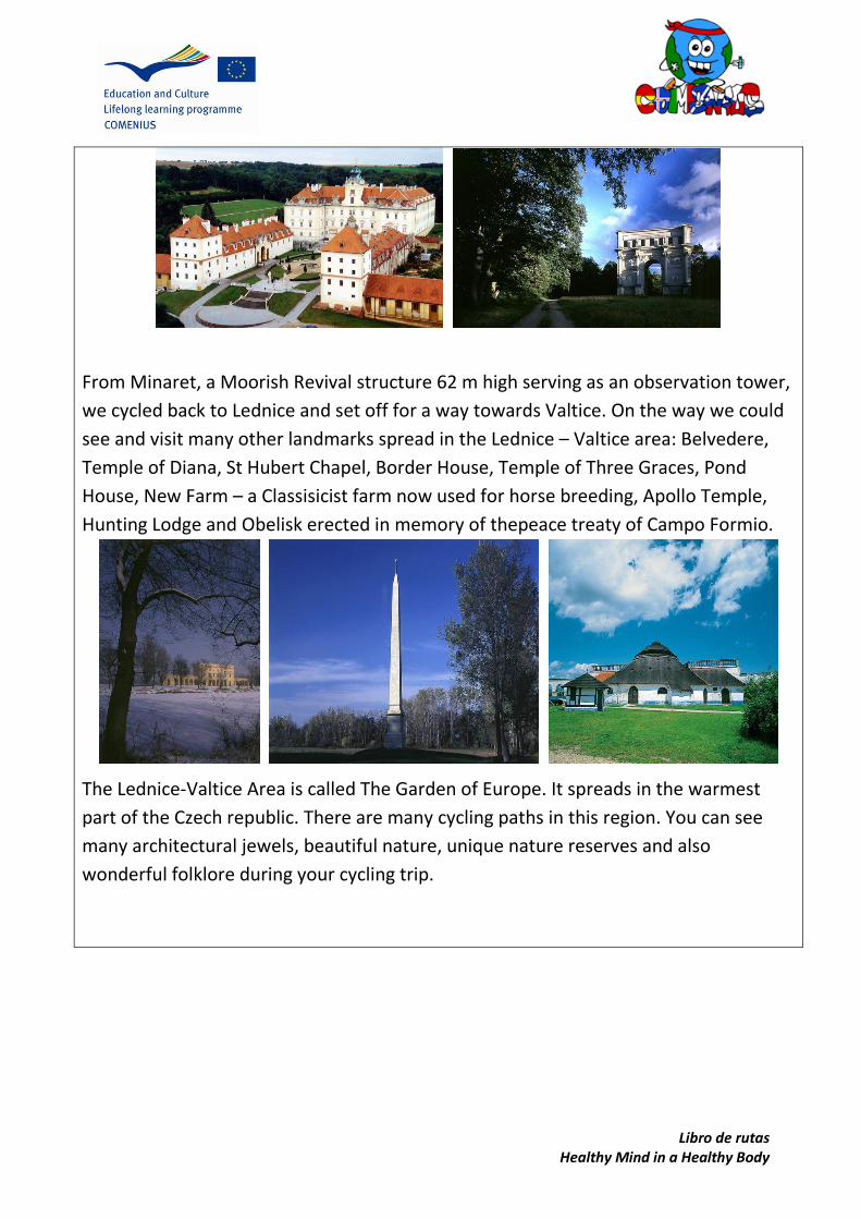
From Minaret, a Moorish Revival structure 62 m high serving as an observation tower,
we cycled back to Lednice and set off for a way towards Valtice. On the way we could
see and visit many other landmarks spread in the Lednice – Valtice area: Belvedere,
Temple of Diana, St Hubert Chapel, Border House, Temple of Three Graces, Pond
House, New Farm – a Classisicist farm now used for horse breeding, Apollo Temple,
Hunting Lodge and Obelisk erected in memory of thepeace treaty of Campo Formio.
The Lednice-Valtice Area is called The Garden of Europe. It spreads in the warmest
part of the Czech republic. There are many cycling paths in this region. You can see
many architectural jewels, beautiful nature, unique nature reserves and also
wonderful folklore during your cycling trip.
Libro de rutas Healthy Mind in a Healthy Body
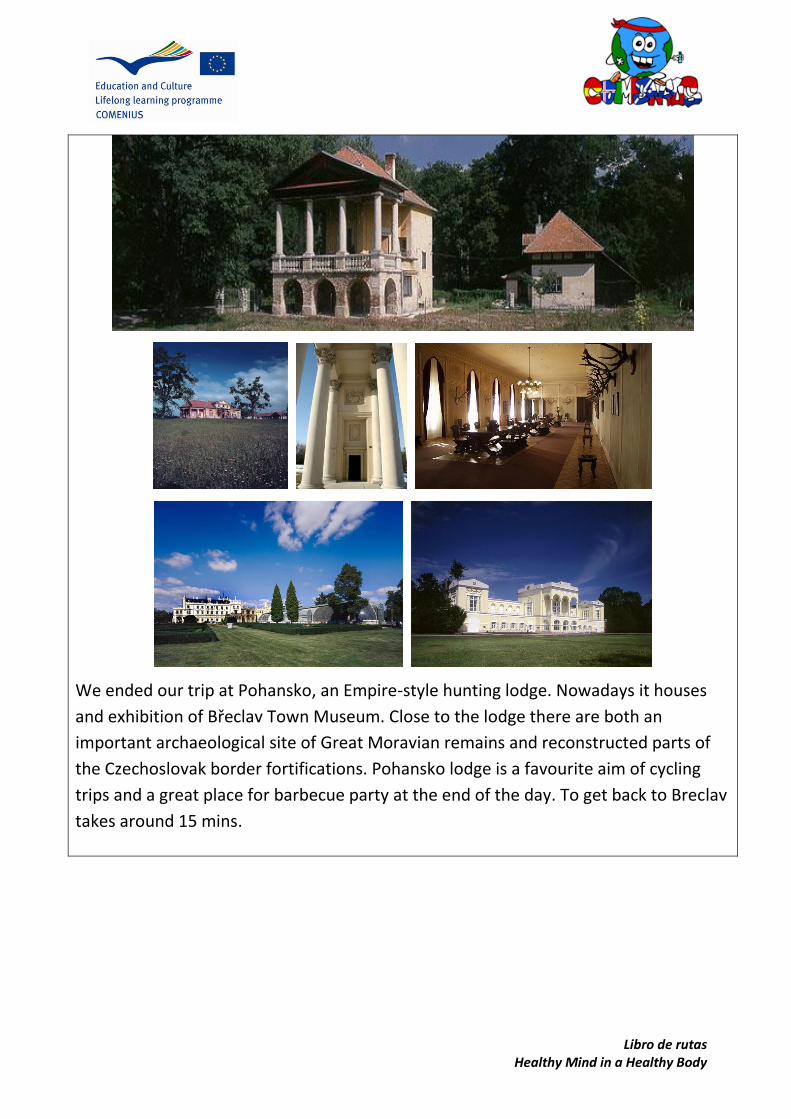
We ended our trip at Pohansko, an Empire-style hunting lodge. Nowadays it houses
and exhibition of Břeclav Town Museum. Close to the lodge there are both an
important archaeological site of Great Moravian remains and reconstructed parts of
the Czechoslovak border fortifications. Pohansko lodge is a favourite aim of cycling
trips and a great place for barbecue party at the end of the day. To get back to Breclav
takes around 15 mins.

Libro
de ru
tas
Hea
lthy M
ind
in a
Hea
lthy B
od
y
PO
INTS O
F INTER
EST ON
THE R
OU
TE
Libro de rutas Healthy Mind in a Healthy Body
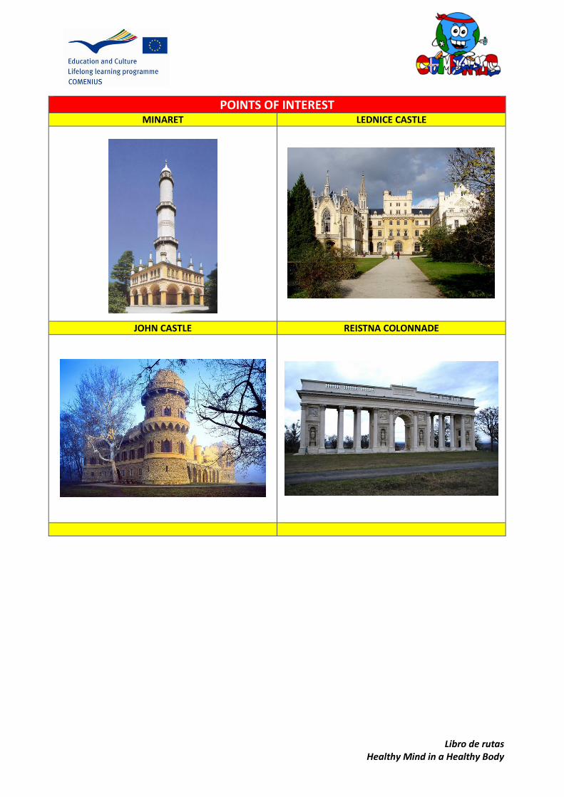
POINTS OF INTEREST
MINARET LEDNICE CASTLE
JOHN CASTLE REISTNA COLONNADE

Libro de rutas Healthy Mind in a Healthy Body
POINTS OF INTEREST
VALTICE CASTLE POHANSKO
ICELAND Stóru-Vogaskóli, Vogar

Libro de rutas Healthy Mind in a Healthy Body
Keilir
COUNTRY AREA LOCATION
ROUTE FILE
DISTANCE TIME SURFAVE SKILL LEVEL 379 (Height) 4 hours Lava and gravel Medium to difficult
RO
UTE
START POINT
FULL
ITEN
ERA
Y Höskuldarvellir
Oddskarð Keilir
Vogar
FINISH POINT
Keilir
MAP

Libro de rutas Healthy Mind in a Healthy Body
SUGGESTIONS AND OTHER INTERESTING DATA
Good hiking boots and clothes according weather Hiking staffs would also come in handy
WALK DESCRIPTION
Keilir is located in Vogar Vatnsleysuströnd on the Reykjavík peninsula in Iceland. Keilir
is an extinct volvano and is located in an area lava. It is rather difficult to walk and
although only 379 meters high the surface is very “loose and sandy” and it almost
seems as for each step you take up the mountain you slide down two steps!

Libro
de ru
tas
Hea
lthy M
ind
in a
Hea
lthy B
od
y
PO
INTS O
F INTER
EST ON
THE R
OU
TE
1
21
3
4
(On
a map
, locate
and
illustrate w
ith p
ictures th
e mo
st imp
ortan
t
land
marks an
d p
oin
ts of in
terests in th
e area)

Libro de rutas Healthy Mind in a Healthy Body
POI’s
1. Picture is taken from Reykjavík the capital of Iceland which is some 40 km away.
3. From Oddafell there is a pathway that has been made from the many hikers that have walked up and
down Keilir. .
4. On top of Keilir
On top of Keilir there is a guestbook and hikers are expected to wriet their names and the date they are
there in the book.
2. The best way to get to Keilir is to drive by
car to Höskuldarhólar. From there the walk
begins and takes about 4-6 hours to climb
up the mountain and back down to
Höskuldarhólar.

ITALY Istituto Omnicomprensivo statale
Alvito, Lazio
Ro
ute
Bo
ok
Hea
lth
y M
ind
in a
Hea
lth
y B
od
y
Alv
ito
–A
tin
a-Sa
n D
on
ato
VC
CO
UN
TRY
A
REA
LO
CA
TIO
N
RO
UTE
FIL
E
DIS
TAN
CE
TIM
E SU
RFA
VE
SKIL
L LE
VEL
(in
km
) 2
6 k
m
2 h
ou
rs b
ike
1
ho
ur
car
Mai
nly
pav
ed
-u
np
ave
d
gra
vel)
m
ed
ium
FRO
SIN
ON
E
Ro
ute B
oo
k H
ealth
y Min
d in
a H
ealth
y Bo
dy
ROUTE
STAR
T PO
INT
FULL ITENERAY
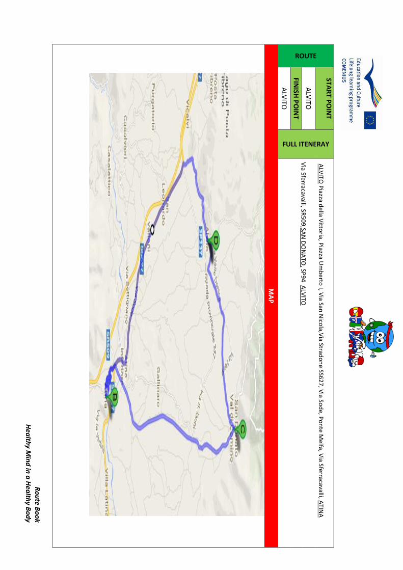
ALV
ITO P
iazza della V
ittoria, P
iazza Um
berto
I, Via San
Nico
la,Via Strad
on
e SS6
27
, Via So
de, P
on
te Melfa, V
ia Sferracavalli, ATIN
A
Via Sferracavalli, SR
50
9,SA
N D
ON
ATO
, SP9
4 A
LVITO
ALV
ITO
FINISH
PO
INT
ALV
ITO
MA
P

Ro
ute
Bo
ok
Hea
lth
y M
ind
in a
Hea
lth
y B
od
y
SUG
GES
TIO
NS
AN
D O
THER
INTE
RES
TIN
G D
ATA
Taki
ng
foo
d o
r w
ater
may
be
advi
sab
le b
ut
ther
e ar
e p
ub
lic f
ou
nta
ins
avai
lab
le o
n t
he
way
, ta
kin
g a
rain
coat
or
som
e ex
tra
clo
thes
mig
ht
be
nec
essa
ry if
th
e w
eath
er c
han
ges.
In s
um
mer
tak
e a
hat
sin
ce it
bec
om
es q
uit
e h
ot
and
so
lar
rad
iati
on
is h
igh
.
It
is a
lso
ad
visa
ble
to
wea
r co
mfo
rtab
le s
ho
es s
ince
th
e vi
sit
in t
he
an
cien
t ca
stle
ru
ins
in
clu
des
clim
bin
g an
d d
esce
nd
ing
rock
y p
ath
way
s.
Ther
e ar
e b
ars,
sh
op
s re
stau
ran
ts a
lon
g th
e w
ay.
WA
LK D
ESC
RIP
TIO
N
Ou
r tr
ip b
egin
s in
th
e ce
ntr
al P
iazz
a G
ugl
ielm
o M
arco
ni
of
Alv
ito
. th
e fi
rst
thin
g th
at
on
e n
oti
ces
is t
he
sple
nd
id v
iew
of
the
Val
le D
i C
om
ino
, in
th
e p
rem
isis
th
ere
is t
he
Pal
azzo
Du
cale
o
r P
alaz
zo G
allio
, to
day
it
ho
use
s th
e
adm
inis
trat
ive
off
ices
o
f th
e to
wn
,th
e M
ayo
r’s
off
ice
and
th
e o
ffic
es o
f th
e Lo
cal
Act
ion
Gro
up
of
the
Par
co N
azio
nal
e o
f A
bru
zzo
,La
zio
an
d M
olis
e ,
it w
as
com
ple
ted
by
co
mis
sio
n o
f th
e C
ard
inal
To
lom
e G
allio
wh
o h
ad b
ou
ght
the
Du
chy
of
Alv
ito
in 1
59
5. T
he
Gal
lio
fam
ily
(cam
e fr
om
Co
mo
,) g
ove
rned
Alv
ito
fo
r 2
00
year
s u
nti
ll 1
79
5.
It
has
a b
aro
uq
ue
fasc
ade
Th
e b
uild
ing
has
an
imp
on
ent
en
tran
ce
w
ith
p
illar
s an
d
in
the
mag
nif
isan
t b
uild
ing
ther
e ar
e
the
mo
nu
men
tal
stai
rway
, o
n w
hic
h t
he
du
ke w
ou
ld r
ide
wit
h h
is h
ors
e ,t
he
Sala
del
Tro
no
o
r C
ou
nt’
s Th
ron
e H
all
wh
ich
h
ou
ses
th
e to
wn
Th
eatr
e w
hic
h
was
th
e D
uke
’s a
ud
ien
ce r
oo
m w
ith
sp
len
did
p
ain
ted
wit
h s
cen
es o
f th
e Li
ber
atio
n o
f G
eru
sale
m,a
nd
th
e m
ost
wel
l p
rese
rved
ro
om
is
pre
sen
t d
ay C
ou
nci
l Hal
l wh
ere
we
fin
d s
pen
did
pai
nti
ns
of
the
17
th c
entu
ry.
Wal
kin
g al
on
g w
e g
et t
o P
iazz
a d
ella
Vit
tori
a w
her
e w
e fi
nd
Il M
on
um
ento
ai C
adu
ti a
mem
ori
al O
bel
isk
wh
ich
wan
ts t
o c
om
mem
ora
te t
he
sold
iers
wh
o d
ied
in t
he
II W
orl
d W
ar.

Ro
ute B
oo
k H
ealth
y Min
d in
a H
ealth
y Bo
dy
As w
e walk alo
ng C
orso
Gallio
we
pass a few
large palazzi P
alazzo M
azzenga,P
alazzo G
raziani an
d P
alazzo Sip
ari each b
elon
ged to
the fam
ou
s land
ow
ners o
f
Alvito
and
a mem
ber o
f the Sip
ari Family fo
un
ded
the P
arco N
azion
ale of A
bru
zzo. W
e arrive at th
e R
om
anesq
ue b
ell tow
er of
thech
urch
of San
Simeo
ne
the cen
tral chu
rch e
ntitled
to th
e patro
n sain
t of A
lvito S.Sim
eon
e
(18
th cen
.) is no
tewo
rthy
for its rich
wo
od
en ceilin
g and
, in th
e sacristy, is a pain
ting o
f the
Cru
cifixion
,pro
bab
ly e
xecu
ted
by
Giu
sepp
e C
esari (il
Cavalier
d'A
rpin
o).
We
pass
thro
ugh
the P
orta Iaco
belli
wh
ich
used
to
be th
e Mid
dle age access to
the to
wn
.We w
alk
thro
ugh
the d
oo
r and
we
find
o
urselves in
Viale D
ei Cap
pu
ccini a n
atural gallery
form
ed
by
plan
e trees
wh
ich
are b
eatiful
all year ro
un
d
(the
nam
e
of
this
lane
derive
s fro
m
the
Elemen
ttary sch
oo
l
bu
ildin
g that u
sed to
be a
mo
nastary
of
the
Cap
pu
cini
ord
er
of
friars W
e
p
ass d
ow
n
at
the kio
sk a small typ
ical Italian B
ar and
aggregation
cente
r for lo
cal peo
ple w
e descen
d to
via Giam
osca an
d w
e arrive at
the ro
un
dab
ou
t wh
ere we fin
d a lo
cal bakery an
d th
e Scuo
la Med
ia and
leadin
g to th
e ex-mo
naste
ry of S. N
icho
la,
destro
yed
by
the
earthq
uake in
19
15
, restored
in 1
934
: it has m
aintain
ed
the
cho
rus
and
th
e in
laid cu
pb
oard
s of th
e 18
th cen
tury, o
rdered
by P
op
e
Clem
ent
XIV
.The
Istituto
Te
cnico
A
grario
w
hich
is
ho
used
in
th
is
Ben
edictin
e M
on
astery o
f San N
icola w
ith th
e adjacien
t Ch
urch
of San
Nico
la with
a beatifu
l facade in
Nap
olitain
B
arou
qu
e style. Fo
llow
ing th
e road
we
reach th
e the SS6
27 V
ia Strado
ne ,w
hich
cuts th
e Pian
a of
Alvito
,tod
ay it
is an
in
du
strial zon
e b
ut in
the p
ast it was all agricu
ltural lan
d o
n th
e right th
ere are the Farm
land
s
belo
ngin
g to
th
e Istitu
to A
grario .A
t the cro
ssroad
s we
turn
left on
the w
ay we m
eet an im
po
rtant facto
ry Ballo
ns
Wo
rld fam
ou
s in all o
f Euro
pe an
d o
verseas.
Ro
ute
Bo
ok
Hea
lth
y M
ind
in a
Hea
lth
y B
od
y
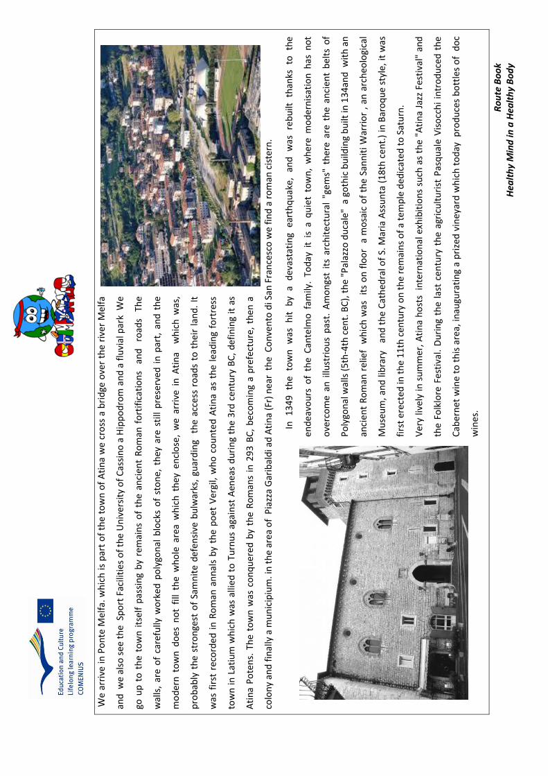
We
arri
ve in
Po
nte
Mel
fa. w
hic
h is
par
t o
f th
e to
wn
of
Ati
na
we
cro
ss a
bri
dge
ove
r th
e ri
ver
Mel
fa
and
we
als
o s
ee
the
Sp
ort
Fac
iliti
es o
f th
e U
niv
ers
ity
of
Cas
sin
o a
Hip
po
dro
m a
nd
a f
luvi
al p
ark
We
go u
p t
o t
he
tow
n i
tsel
f p
assi
ng
by
rem
ain
s o
f th
e an
cien
t R
om
an f
ort
ific
atio
ns
an
d
road
s T
he
wal
ls,
are
of
care
fully
wo
rke
d p
oly
gon
al b
lock
s o
f st
on
e, t
hey
are
sti
ll p
rese
rved
in
par
t, a
nd
th
e
mo
der
n t
ow
n d
oes
no
t fi
ll th
e w
ho
le a
rea
wh
ich
th
ey e
ncl
ose
, w
e ar
rive
in
Ati
na
wh
ich
was
,
pro
bab
ly t
he
stro
nge
st o
f Sa
mn
ite
def
ensi
ve b
ulw
arks
, gu
ard
ing
th
e ac
cess
ro
ads
to t
hei
r la
nd
. It
was
fir
st r
eco
rded
in
Ro
man
an
nal
s b
y th
e p
oet
Ver
gil,
wh
o c
ou
nte
d A
tin
a as
th
e le
adin
g fo
rtre
ss
tow
n i
n L
atiu
m w
hic
h w
as a
llied
to
Tu
rnu
s ag
ain
st A
enea
s d
uri
ng
the
3rd
cen
tury
BC
, d
efin
ing
it a
s
Ati
na
Po
ten
s. T
he
tow
n w
as c
on
qu
ered
by
the
Ro
man
s in
29
3 B
C,
bec
om
ing
a p
refe
ctu
re,
then
a
colo
ny
and
fin
ally
a m
un
icip
ium
. in
th
e ar
ea o
f P
iazz
a G
arib
ald
i ad
Ati
na
(Fr)
nea
r t
he
Co
nve
nto
di S
an F
ran
cesc
o w
e fi
nd
a r
om
an c
iste
rn.
In
1
34
9
the
tow
n
was
h
it
by
a d
evas
tati
ng
eart
hq
uak
e,
and
w
as
reb
uilt
th
anks
to
th
e
end
eavo
urs
of
the
Can
telm
o f
amily
. To
day
it
is a
qu
iet
tow
n,
wh
ere
mo
der
nis
atio
n h
as n
ot
ove
rco
me
an i
llust
rio
us
pas
t. A
mo
ngs
t it
s ar
chit
ect
ura
l "g
ems"
th
ere
are
the
anci
ent
bel
ts o
f
Po
lygo
nal
wal
ls (
5th
-4th
cen
t. B
C),
th
e "P
alaz
zo d
uca
le"
a g
oth
ic b
uild
ing
bu
ilt in
13
4an
d w
ith
an
anci
ent
Ro
man
rel
ief
wh
ich
was
it
s o
n f
loo
r a
mo
saic
of
the
San
nit
i W
arri
or
, an
arc
heo
logi
cal
Mu
seu
m, a
nd
lib
rary
an
d t
he
Cat
hed
ral o
f S.
Mar
ia A
ssu
nta
(1
8th
cen
t.)
in B
aro
qu
e st
yle,
it w
as
firs
t er
ecte
d in
th
e 1
1th
cen
tury
on
th
e re
mai
ns
of
a te
mp
le d
edic
ated
to
Sat
urn
.
Ver
y liv
ely
in s
um
mer
, A
tin
a h
ost
s in
tern
atio
nal
exh
ibit
ion
s su
ch a
s th
e "A
tin
a Ja
zz F
esti
val"
an
d
the
Folk
lore
Fes
tiva
l. D
uri
ng
the
last
cen
tury
th
e ag
ricu
ltu
rist
Pas
qu
ale
Vis
occ
hi
intr
od
uce
d t
he
Cab
ern
et w
ine
to t
his
are
a, in
augu
rati
ng
a p
rize
d v
iney
ard
wh
ich
to
day
p
rod
uce
s b
ott
les
of
do
c
win
es.

Ro
ute B
oo
k H
ealth
y Min
d in
a H
ealth
y Bo
dy
We
descen
d fro
m A
tina an
d at th
e jun
ction
or ro
un
dab
ou
t we
turn
left to th
e SR5
09
in th
e directio
n San
Do
nato
goin
g straight o
n fo
r abo
ut 4
km. W
e pass a
series of fu
rnitu
re stores, restau
rants, p
ub
s, ice cream b
ars and
sup
ermarkets, an
d b
efore arrivin
g in th
e tow
n w
e p
ass the M
on
um
ental C
emitary.
San D
on
ato V
alle di C
om
ino
is an an
cient to
wn
wh
ose n
ame d
erives from
th
e patro
n Sain
t’s nam
e Do
nato
. Its histo
ry
goes b
ack to th
e Mid
dle A
ges, the to
wn
is best see
n o
n fo
ot as th
e ston
e h
ou
ses are in little alleys fo
llow
ing th
e gentile
hillsid
e slop
es on
wh
ich it w
as bu
ilt. On
arriving w
e see
a small p
ark from
w
hich
we
can h
ave access to V
illa Gran
cassa a
wo
nd
erful
Villa
wh
ich w
as
a p
rivate
residen
ce, an
d
later b
ecom
ing
a Sem
inar fo
r the D
iocesis o
f Sora. To
day it is a
ho
tel an
d restau
rant. N
earby th
ere is the C
hiesa d
el Co
nven
to a geo
logical
mu
seum
, and
a you
th h
oste
l, mo
ving o
n w
e
have a recreatio
nal area w
ith sch
oo
ls, bars an
d a large p
ub
lic park w
ith
games an
d attractio
ns.
As w
e m
ove o
n w
e arrive
at the p
iazza del M
on
um
ento
or p
iazza Della V
ittoria an
d fo
llow
ing th
e up
hill ro
ad w
e go th
rou
gh
suggestive
alleys
that
lead to
the
Ch
iesa Mad
re adjacen
t to th
e clock To
we
r of th
e 16 th
centu
ry and
furth
er on
we
get to th
e San
tuario
o
f San D
on
ato.
The to
wn
is famo
us fo
r its
sto
ne
cutte
rs so th
e tow
n h
as m
any
beau
tiful
keysto
nes o
n th
e arches
that
orn
ate th
e do
ors.
On
leaving th
e tow
n w
e fo
llow
th
e d
ow
nw
ard
road
to
ward
s A
lvito
crossin
g a
flat p
lain
called
Cam
po
Gu
errano
SS77 w
here
a fam
ou
s
battle to
ok p
lace du
ring
the
To
day
it is the lo
cation
wh
ere h
and
gliders lan
d
and
m
eet,
descen
din
g fro
m th
e mo
un
tainsid
e of A
pp
enn
ino
Laziale from
the
locality called
Tre
Po
nti1
. Furth
er on
we fin
d th
e Ch
urch
of San
ta Maria d
el Cam
po
of 1
09
0, o
ne o
f the o
ldest o
f the to
wn
with
a w
oo
den
statue o
f
the M
ado
nn
a del C
amp
o o
f 149
6. W
e arrive in A
lvito p
assing alo
ng V
ia Del Litto
rio w
here th
ere is the To
rre C
olo
mb
aia
The
"Palo
mb
ara", a do
vecote to
wer o
f the (X
Vth
Ce
ntu
ry) partially co
llapsed
on
the 2
3rd
of Jan
uary 2
014
.

Ro
ute
Bo
ok
Hea
lth
y M
ind
in a
Hea
lth
y B
od
y
PO
INTS
OF
INTE
RES
T O
N T
HE
RO
UTE
1
2 1
3
4
5
6
Route Book Healthy Mind in a Healthy Body
POINTS OF INTEREST
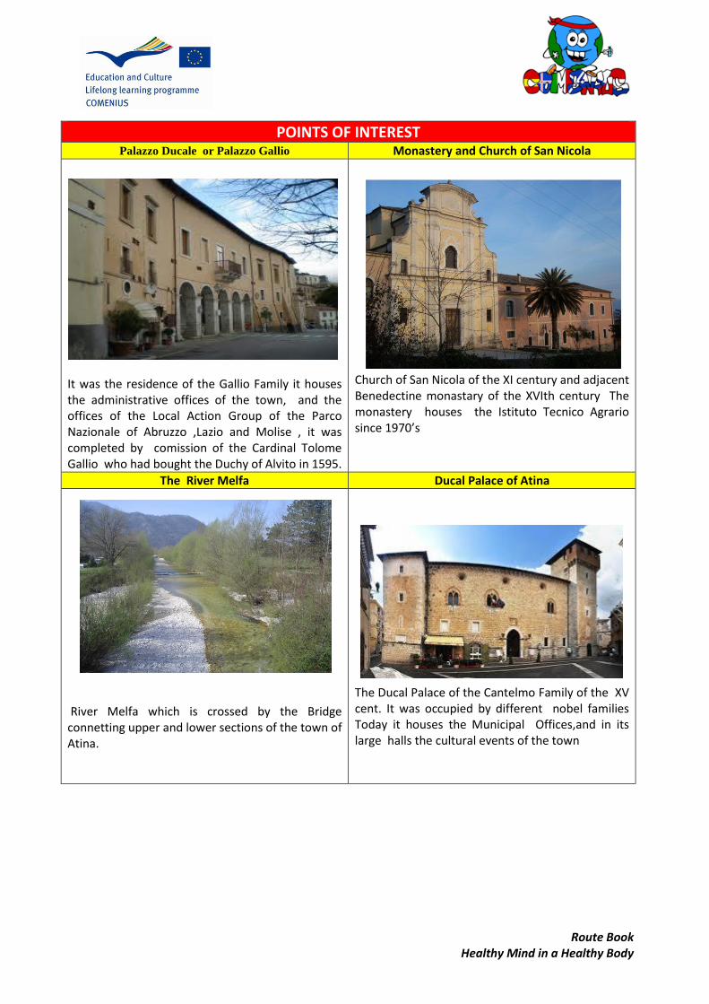
Palazzo Ducale or Palazzo Gallio Monastery and Church of San Nicola
It was the residence of the Gallio Family it houses the administrative offices of the town, and the offices of the Local Action Group of the Parco Nazionale of Abruzzo ,Lazio and Molise , it was completed by comission of the Cardinal Tolome Gallio who had bought the Duchy of Alvito in 1595.
Church of San Nicola of the XI century and adjacent Benedectine monastary of the XVIth century The monastery houses the Istituto Tecnico Agrario since 1970’s
The River Melfa Ducal Palace of Atina
River Melfa which is crossed by the Bridge connetting upper and lower sections of the town of Atina.
The Ducal Palace of the Cantelmo Family of the XV cent. It was occupied by different nobel families Today it houses the Municipal Offices,and in its large halls the cultural events of the town
Route Book Healthy Mind in a Healthy Body
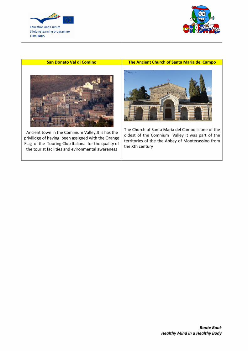
San Donato Val di Comino The Ancient Church of Santa Maria del Campo
Ancient town in the Cominium Valley,It is has the privilidge of having been assigned with the Orange Flag of the Touring Club Italiana for the quality of the tourist facilities and evironmental awareness
The Church of Santa Maria del Campo is one of the oldest of the Comnium Valley it was part of the territories of the the Abbey of Montecassino from the Xth century
Ro
ute B
oo
k H
ealth
y Min
d in
a H
ealth
y Bo
dy
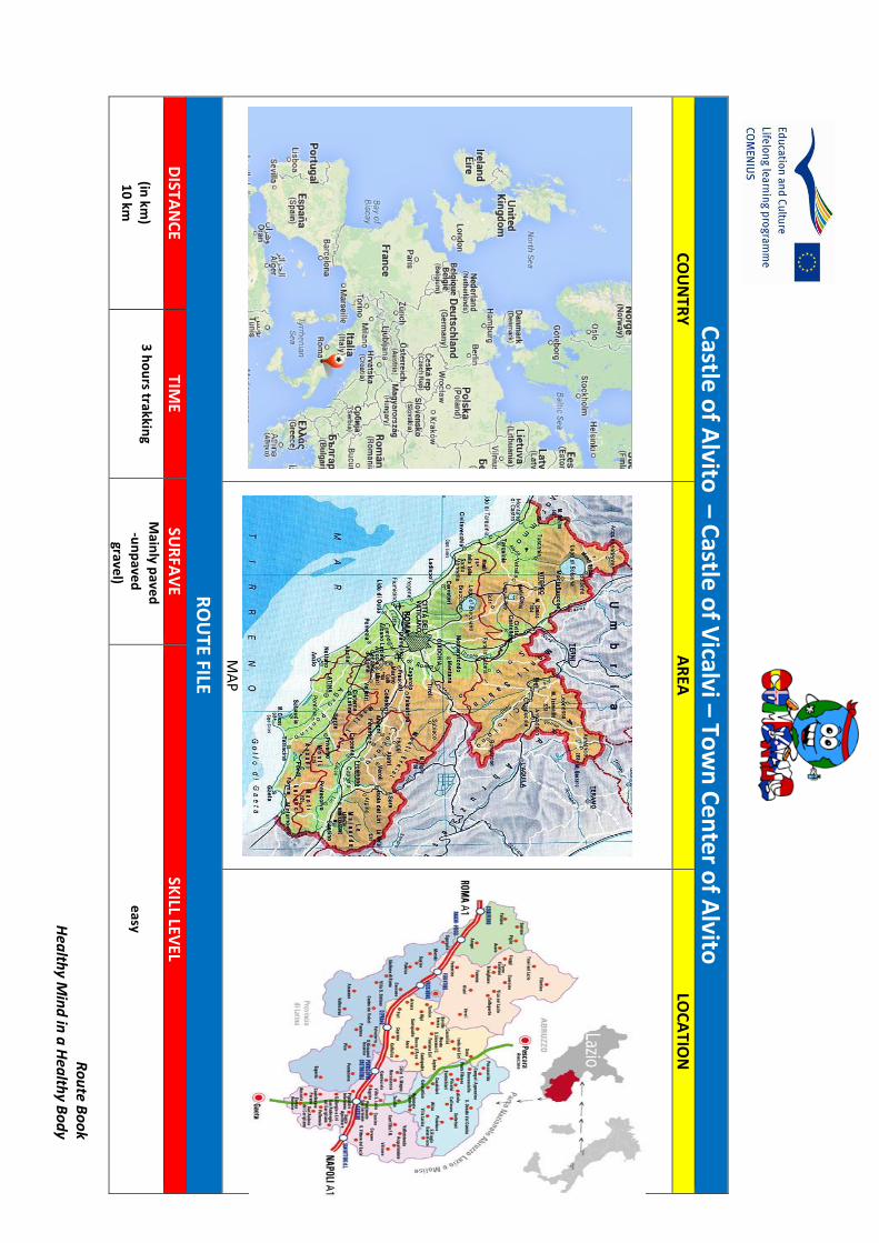
Castle
of A
lvito – C
astle o
f Vicalvi – To
wn
Ce
nter o
f Alvito
CO
UN
TRY
A
REA
LO
CA
TION
MA
P
RO
UTE FILE
DISTA
NC
E TIM
E SU
RFA
VE
SKILL LEV
EL
(in km
) 1
0 km
3 h
ou
rs trakking
Main
ly pave
d
-un
pave
d
gravel)
easy
Ro
ute
Bo
ok
Hea
lth
y M
ind
in a
Hea
lth
y B
od
y
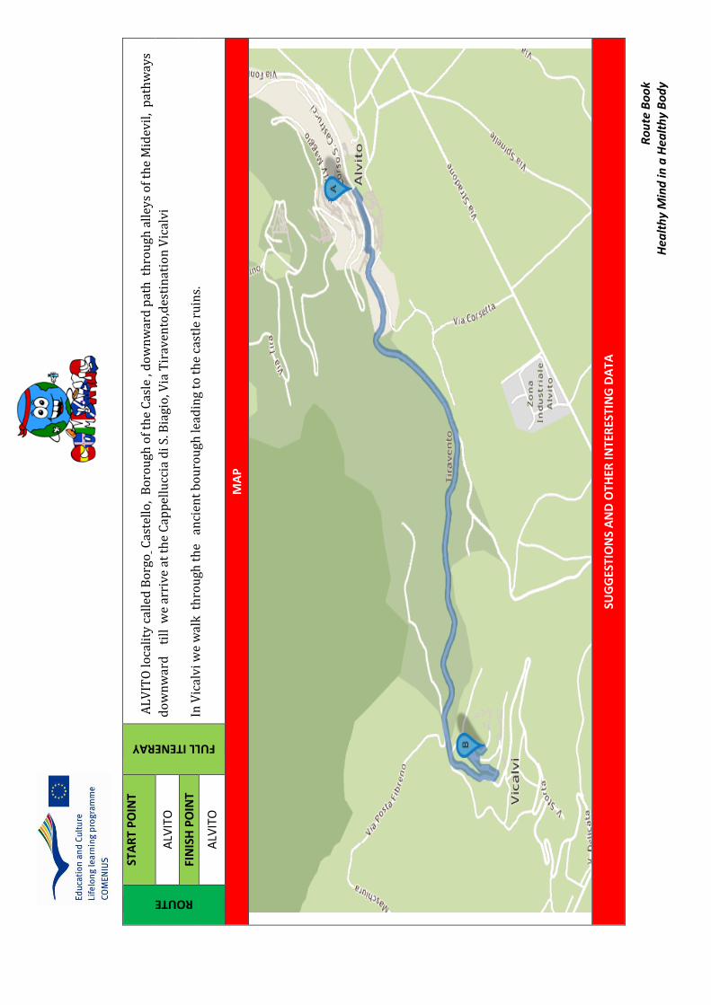
ROUTE
STA
RT
PO
INT
FULL ITENERAY
AL
VIT
O lo
cali
ty c
alle
d B
org
o C
aste
llo
, B
oro
ugh
of
the
Cas
le ,
do
wn
war
d p
ath
th
rou
gh a
lley
s o
f th
e M
idev
il,
pat
hw
ays
do
wn
war
d
til
l w
e ar
rive
at
the
Cap
pel
lucc
ia d
i S.
Bia
gio
, Via
Tir
aven
to,d
esti
nat
ion
Vic
alvi
In V
ical
vi w
e w
alk
th
rou
gh t
he
an
cien
t b
ou
rou
gh le
adin
g to
th
e ca
stle
ru
ins.
ALV
ITO
FIN
ISH
PO
INT
ALV
ITO
MA
P
SUG
GES
TIO
NS
AN
D O
THER
INTE
RES
TIN
G D
ATA

Ro
ute B
oo
k H
ealth
y Min
d in
a H
ealth
y Bo
dy
Taking fo
od
or w
ater may b
e advisab
le b
ut th
ere are p
ub
lic fou
ntain
s available o
n th
e way, takin
g a rainco
at or so
me extra clo
thes m
ight b
e n
ecessary if the w
eather ch
anges.
In su
mm
er take a hat sin
ce it beco
mes q
uite h
ot an
d so
lar radiatio
n is h
igh.
It is also ad
visable to
wear co
mfo
rtable sh
oes sin
ce the visit in
the an
cient castle ru
ins in
clud
es climb
ing an
d d
escend
ing ro
cky path
ways.
There are b
ars, sho
ps restau
rants alo
ng th
e way.
WA
LK D
ESCR
IPTIO
N
We start o
ur to
ur in
fron
t of th
e ruin
s of th
e Castel o
f Alvito
, bu
ilt for th
e first time at th
e end
of X
I centu
ry, alon
g the A
lbeto
Mo
un
t slop
es. It was b
uilt b
y the
cou
nt o
f Aq
uin
o d
escend
ing fro
m th
e Lon
gob
ard d
ukes o
f Ben
evento
, At th
e end
of th
e XII cen
tury, east o
f Alb
eto M
ou
nt alo
ng th
e hill th
at is called to
day, th
e C
ivita, little by little b
egan to
be ab
and
on
ed b
ecause p
art of th
e po
pu
lation
establish
ed aro
un
d th
e castle near th
e place th
at becam
e the "C
ittadella" su
rrou
nd
ed
by its w
alls with
its three d
oo
rs. Oth
ers settled
alon
g the slo
pe b
elow
, tight aro
un
d
a chu
rch, th
at con
tribu
ted
to th
e form
ation
o
f Co
min
o V
alley. The m
edieval castle, ju
st as w
e can
see it
tod
ay is
wh
at rem
ains
of
the
rebu
ildin
g after
the
earthq
uake
that
in
the
year 1
349
had
d
amaged
th
e stro
ng
walls.
The
new
bu
ildin
g imm
ediately b
uilt in
the year
135
0 th
anks to
Ro
staino
Can
telm
o w
ho
se ancesto
rs had
arrived
in Italy am
on
g the su
it of C
arlo d
'An
giò. Th
e Can
telm
o en
tered in
po
ssession
of th
e castle becau
se h
e was related
with
the p
reviou
s lord
s, the co
un
ts of A
qu
ino
wh
o d
ied in
the earth
qu
ake . They h
ad b
een lo
rds o
f Alvito
till 1497
. Du
ring th
e XV
I centu
ry, the
Can
telm
o w
ere fo
llow
ed
by B
orgia, N
avarra, Card
on
a and
Gallio
families. Th
e latter, after beco
min
g du
kes ab
and
on
ed th
e castle and
bu
ilt the D
ucal P
alace and
Ro
ute
Bo
ok
Hea
lth
y M
ind
in a
Hea
lth
y B
od
y
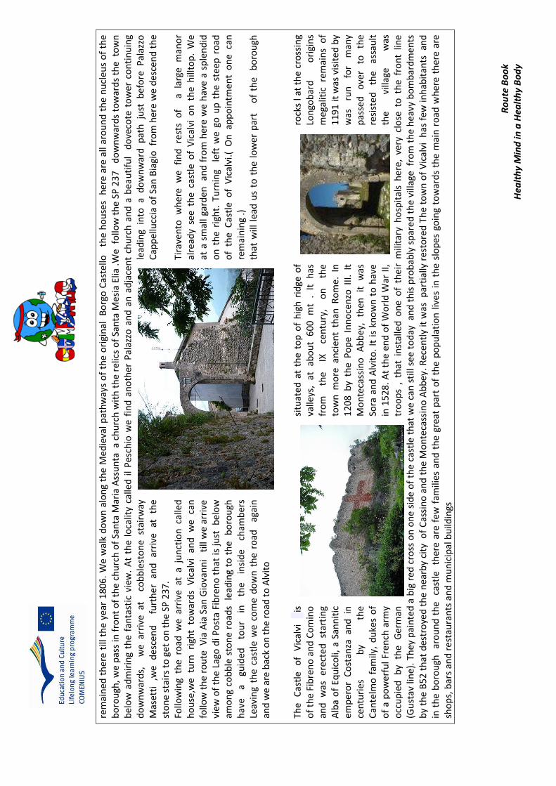
rem
ain
ed t
her
e ti
ll th
e ye
ar 1
806
. W
e w
alk
do
wn
alo
ng
the
Med
ieva
l p
ath
way
s o
f th
e o
rigi
nal
B
org
o C
aste
llo
th
e h
ou
ses
her
e ar
e al
l aro
un
d t
he
nu
cleu
s o
f th
e b
oro
ugh
, we
pas
s in
fro
nt
of
the
chu
rch
of
San
ta M
aria
Ass
un
ta a
ch
urc
h w
ith
th
e re
lics
of
San
ta M
esia
Elia
.We
fo
llow
th
e SP
23
7
do
wn
war
ds
tow
ard
s th
e t
ow
n
bel
ow
ad
mir
ing
the
fan
tast
ic v
iew
. A
t th
e lo
calit
y ca
lled
il
Pes
chio
we
fin
d a
no
ther
Pal
azzo
an
d a
n a
dja
cen
t ch
urc
h a
nd
a b
eau
tifu
l d
ove
cote
to
wer
co
nti
nu
ing
do
wn
war
ds,
w
e ar
rive
at
co
bb
lest
on
e st
airw
ay
lead
ing
into
a d
ow
nw
ard
pat
h j
ust
bef
ore
Pal
azzo
M
aset
ti
,we
des
cen
d
fu
rth
er
and
ar
rive
at
th
e C
app
ellu
ccia
of
San
Bia
gio
fro
m h
ere
we
des
cen
d t
he
sto
ne
stai
rs t
o g
et o
n t
he
SP 2
37.
Follo
win
g th
e ro
ad w
e a
rriv
e a
t a
jun
ctio
n c
alle
d
Tira
ven
to
wh
ere
we
fi
nd
re
sts
of
a
larg
e m
ano
r h
ou
se,w
e tu
rn
righ
t to
war
ds
Vic
alvi
an
d
we
ca
n
alre
ady
see
th
e ca
stle
of
Vic
alvi
on
th
e h
illto
p.
We
follo
w t
he
rou
te V
ia A
ia S
an G
iova
nn
i t
ill w
e a
rriv
e
at a
sm
all
gard
en
and
fro
m h
ere
we
hav
e a
sple
nd
id
view
of
the
Lago
di P
ost
a Fi
bre
no
th
at i
s ju
st
bel
ow
o
n t
he
righ
t. T
urn
ing
lef
t w
e g
o u
p t
he
ste
ep r
oad
am
on
g co
bb
le s
ton
e ro
ads
lea
din
g to
th
e b
oro
ugh
o
f th
e C
astl
e o
f V
ical
vi.(
On
ap
po
intm
ent
on
e ca
n
hav
e a
guid
ed
tou
r in
th
e in
sid
e ch
amb
ers
rem
ain
ing
.)
Leav
ing
the
cast
le w
e c
om
e d
ow
n t
he
road
ag
ain
th
at w
ill l
ead
us
to t
he
low
er
par
t
of
the
bo
rou
gh
and
we
are
bac
k o
n t
he
road
to
Alv
ito
Th
e C
astl
e o
f V
ical
vi
is
si
tuat
ed
at
the
top
of
hig
h r
idge
of
rock
s l a
t th
e cr
oss
ing
of
the
Fib
ren
o a
nd
Co
min
o
valle
ys,
at
abo
ut
60
0
mt
. It
h
as
Lon
gob
ard
o
rigi
ns
and
w
as
erec
ted
st
arti
ng
fro
m
the
IX
cen
tury
, o
n
the
meg
alit
ic
rem
ain
s o
f A
lba
of
Equ
ico
li, a
San
nit
ic
tow
n m
ore
an
cien
t th
an R
om
e. I
n
11
91
it w
as v
isit
ed
by
emp
ero
r C
ost
anza
an
d i
n
12
08
by
the
Po
pe
Inn
oce
nzo
III
. It
w
as
run
fo
r m
any
cen
turi
es
by
the
Mo
nte
cass
ino
A
bb
ey,
then
it
w
as
pas
sed
o
ver
to
the
Can
telm
o f
amily
, d
uke
s o
f So
ra a
nd
Alv
ito
. It
is
kno
wn
to
hav
e re
sist
ed
th
e as
sau
lt
of
a p
ow
erf
ul F
ren
ch a
rmy
in 1
52
8.
At
the
end
of
Wo
rld
War
II,
the
villa
ge
was
o
ccu
pie
d
by
the
Ger
man
tr
oo
ps
, th
at i
nst
alle
d o
ne
of
thei
r m
ilita
ry h
osp
ital
s h
ere,
ver
y cl
ose
to
th
e fr
on
t lin
e (G
ust
av li
ne)
. Th
ey p
ain
ted
a b
ig r
ed c
ross
on
on
e si
de
of
the
cast
le t
hat
we
can
sti
ll se
e t
od
ay a
nd
th
is p
rob
ably
sp
ared
th
e vi
llage
fro
m t
he
hea
vy b
om
bar
dm
ents
b
y th
e B
52 t
hat
des
tro
yed
th
e n
earb
y ci
ty o
f C
assi
no
an
d t
he
Mo
nte
cass
ino
Ab
bey
. Rec
en
tly
it w
as p
arti
ally
res
tore
d T
he
tow
n o
f V
ical
vi h
as f
ew in
hab
itan
ts a
nd
in
th
e b
oro
ugh
ar
ou
nd
th
e c
astl
e t
her
e ar
e fe
w f
amili
es a
nd
th
e gr
eat
par
t o
f th
e p
op
ula
tio
n l
ives
in
th
e sl
op
es g
oin
g to
war
ds
the
mai
n r
oad
wh
ere
ther
e ar
e sh
op
s, b
ars
and
res
tau
ran
ts a
nd
mu
nic
ipal
bu
ildin
gs

Ro
ute B
oo
k H
ealth
y Min
d in
a H
ealth
y Bo
dy
PO
INTS O
F INTER
EST ON
THE R
OU
TE
3
4
1
2
5
Route Book Healthy Mind in a Healthy Body
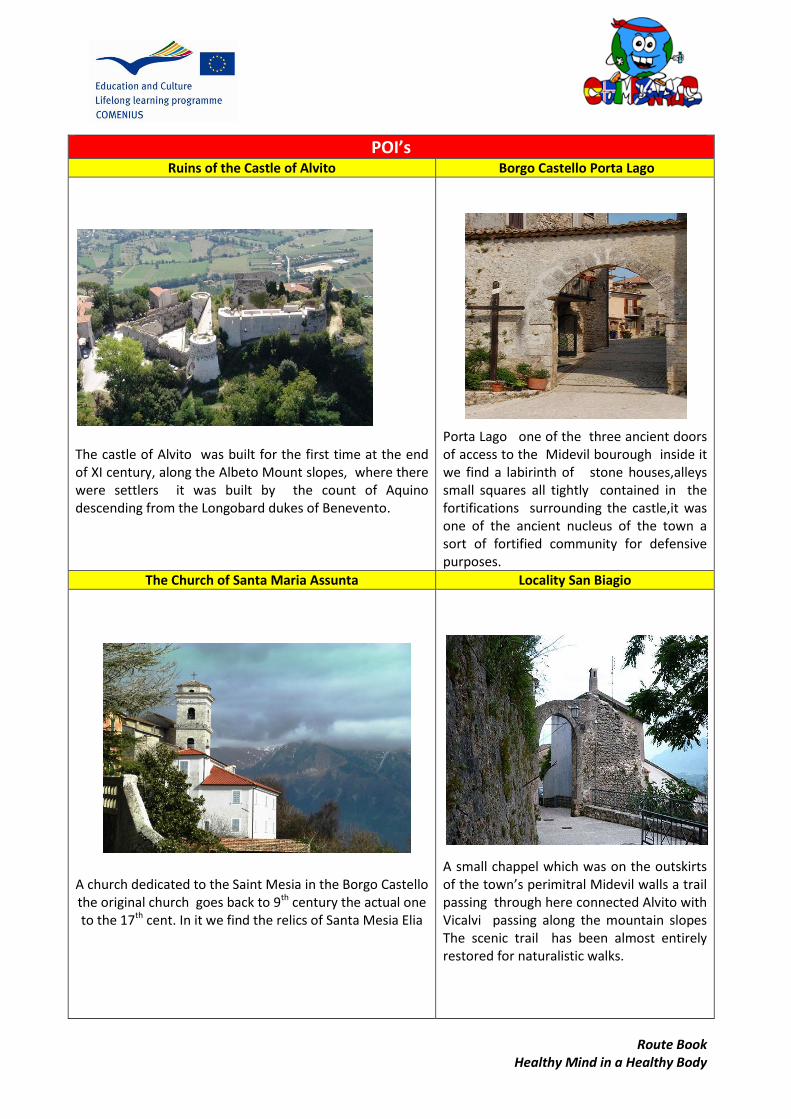
POI’s Ruins of the Castle of Alvito Borgo Castello Porta Lago
The castle of Alvito was built for the first time at the end of XI century, along the Albeto Mount slopes, where there were settlers it was built by the count of Aquino descending from the Longobard dukes of Benevento.
Porta Lago one of the three ancient doors of access to the Midevil bourough inside it we find a labirinth of stone houses,alleys small squares all tightly contained in the fortifications surrounding the castle,it was one of the ancient nucleus of the town a sort of fortified community for defensive purposes.
The Church of Santa Maria Assunta Locality San Biagio
A church dedicated to the Saint Mesia in the Borgo Castello the original church goes back to 9th century the actual one to the 17th cent. In it we find the relics of Santa Mesia Elia
A small chappel which was on the outskirts of the town’s perimitral Midevil walls a trail passing through here connected Alvito with Vicalvi passing along the mountain slopes The scenic trail has been almost entirely restored for naturalistic walks.
Route Book Healthy Mind in a Healthy Body
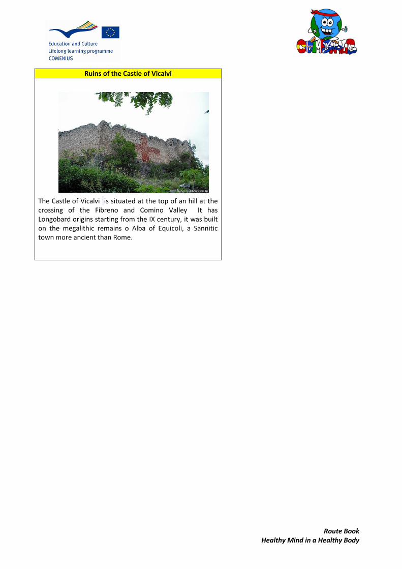
Ruins of the Castle of Vicalvi
The Castle of Vicalvi is situated at the top of an hill at the crossing of the Fibreno and Comino Valley It has Longobard origins starting from the IX century, it was built on the megalithic remains o Alba of Equicoli, a Sannitic town more ancient than Rome.
Ro
ute
Bo
ok
Hea
lth
y M
ind
in a
Hea
lth
y B
od
y
Po
sta
Fib
ren
o –
So
ra –
Iso
la d
el L
iri
CO
UN
TRY
A
REA
LO
CA
TIO
N
RO
UTE
FIL
E
DIS
TAN
CE
TIM
E SU
RFA
VE
SKIL
L LE
VEL
(in
km
) 2
0km
30
min
ute
s ri
de
+ 1
ho
ur
for
wal
ks
Pav
ed
ro
ads
eas
y

Ro
ute B
oo
k H
ealth
y Min
d in
a H
ealth
y Bo
dy
ROUTE
STAR
T PO
INT
FULL ITENERAY
Po
sta Fib
reno
lake sid
e road
, Po
nte T
apin
o , b
ridge o
n th
e Fib
reno
River an
affluen
t of th
e lake V
ia Sferracavalli, So
ra,
Po
nte d
i Ferro
wh
ich cro
sses the L
iri River an
affluen
t of th
e Fib
reno
,
Co
rso V
olsci, P
on
te di N
apo
li,Via N
apo
li ,Viale San
Do
men
ico,
Isola Su
perio
re,Isola D
el Liri
PO
STA FIB
REN
O
FINISH
PO
INT
ISOLA
DEL LIR
I
MA
P

Ro
ute
Bo
ok
Hea
lth
y M
ind
in a
Hea
lth
y B
od
y
SUG
GES
TIO
NS
AN
D O
THER
INTE
RES
TIN
G D
ATA
Taki
ng
foo
d o
r w
ater
may
be
advi
sab
le b
ut
ther
e ar
e p
ub
lic f
ou
nta
ins
avai
lab
le o
n t
he
way
, ta
kin
g a
rain
coat
or
som
e ex
tra
clo
thes
mig
ht
be
nec
essa
ry if
th
e w
eath
er c
han
ges.
In s
um
mer
tak
e a
hat
sin
ce it
bec
om
es q
uit
e h
ot
and
so
lar
rad
iati
on
is h
igh
.
It
is a
lso
ad
visa
ble
to
wea
r co
mfo
rtab
le s
ho
es s
ince
it is
a p
leas
ure
to
wal
k al
on
g th
e la
ke a
nd
in t
he
tow
ns
of
Sora
an
d Is
ola
del
Lir
i

Ro
ute B
oo
k H
ealth
y Min
d in
a H
ealth
y Bo
dy
WA
LK D
ESCR
IPTIO
N
Ou
r jou
rney b
egins th
e Mu
lino
ad A
cqu
a the W
ater Mill fo
r the grin
din
g of grain
It l was b
uilt in
1810
in th
e locality o
f Sorgen
tina b
y the Lo
rds Lecce an
d R
uggeri.
The M
ills and
dep
end
encies w
ere acqu
ired b
y the Ferran
te fam
ily of A
lvito in
1851
.
At th
e begin
nin
g of th
e twen
tieth cen
tury ( 1
905
-1908
) next to
the o
riginal b
uild
ing , G
iovan
diego
Ferrante
mad
e a small h
ydro
electric po
we
r plan
t than
ks to w
hich
it was p
ossib
le to illu
min
ate
electrically Alvito
. The sam
e dyn
amo
, miracu
lou
sly spared
from
Germ
an arm
y attacks and
destru
ction
tow
ards th
e end
of th
e occu
patio
n , p
rovid
ed en
ergy for m
any m
on
ths to
ten
neigh
bo
ring
mu
nicip
alities of th
e Co
min
ium
Valley
The
mill
wo
rked
regu
larly u
ntil
the
begin
nin
g o
f th
e 1
98
0s
it w
as
later
bo
ugh
t by th
e mu
nicip
ality of P
ost
Fibren
o
In
the
early years
of
this
centu
ry the p
rop
erty was resto
red an
d
the o
riginal m
achin
es (turb
ines , gen
erators w
ere emp
ow
ered
to ru
n again
for ed
ucatio
nal p
urp
oses.
Ad
jacent to
the m
ill there is p
icnic area fro
m w
hich
, via a small p
ath , yo
u can
reach th
e left ban
k of
the lake " .Th
e mill can
be visite
d as p
art of a p
rocess o
f guid
ed to
ur, b
oo
ked at th
e offices o
f Riserva
Natu
rale Re
gion
ale Lago d
i Po
sta Fibren
o.

Ro
ute
Bo
ok
Hea
lth
y M
ind
in a
Hea
lth
y B
od
y
Fro
m t
he
Mill
w
e a
rriv
e at
th
e N
atu
ral
Res
erv
e o
f P
ost
a Fi
bre
no
, w
e f
ollo
w t
he
road
alo
ng
the
rive
r Fi
bre
no
an
d w
e a
rriv
e a
t a
reso
rt a
rea
on
th
e la
ke w
alki
ng
alo
ng
the
lake
.W
e ca
n a
dm
ire
its
exte
nsi
on
an
d s
ee t
he
ott
ers
,du
cks
and
wild
life
. It
is p
oss
ible
to
hir
e a
ped
alò
or
typ
ical
sm
all r
ow
bo
at t
o h
ave
an e
xcu
rsio
n
on
th
e la
ke.
Ther
e ar
e b
ed a
nd
bre
akfa
sts,
res
tau
ran
ts a
nd
pic
k n
ick
area
s an
d b
ars.
A
lon
g th
e w
alk
we
ca
n
visi
t th
e LA
B.T
ER
Lab
ora
tori
o
Terr
ito
rial
e d
i Ed
uca
zio
ne
Am
bie
nta
le
an
ac
qu
atic
m
use
um
of
the
par
k an
d a
dja
cen
t vi
sait
ors
cen
tre.
La
ke
Po
sta
Fib
ren
o
off
ers
an
o
pp
ort
un
ity
to
un
der
take
in
tere
stin
g ex
curs
ion
s in
a
nat
ura
l, ev
oca
tive
se
ttin
g,
dis
cove
rin
g a
man
y-fa
cete
d l
and
. O
ne
feat
ure
, p
erh
aps
un
iqu
e in
Eu
rop
e, a
nd
alr
ead
y m
enti
on
ed b
y P
liny
in h
is
"Nat
ura
lis H
isto
ria"
, is
rep
rese
nte
d b
y th
e p
rese
nce
of
a fl
oat
ing
isla
nd
cal
led
La
Ro
ta T
he
"Ro
ta”
form
ed b
y rh
izo
mes
, pea
t an
d r
oo
ts, a
ble
to
mo
ve i
n d
iffe
ren
t p
arts
of
the
year
du
e to
gen
tle
bre
eze
s o
r t
o t
he
incr
ease
in
th
e fl
ow
of
the
spri
ngs
th
at f
low
nea
rby
. Per
hap
s th
e ch
emic
al c
om
po
siti
on
of
the
isla
nd
tre
es
that
are
fo
un
d o
n t
he
surf
ace
do
no
t d
evel
op
as
they
do
on
lan
d
they
gr
ow
lit
tle
mo
re t
han
mer
e sh
rub
s W
ith
its
hig
h-q
ual
ity
wat
er,
the
lake
is h
om
e to
a r
ich
nat
ura
l lif
e: h
ors
etai
l an
d m
acro
ph
ysit
s, r
eed
s an
d m
arsh
fer
n a
ll ab
ou
nd
. Th
e la
ke’s
wat
er,
sin
ce i
t is
co
nti
nu
ou
sly
exch
ange
d,
mai
nta
ins
a vi
rtu
ally
co
nst
ant
tem
per
atu
re (
10
-11
°C).
Hig
hly
oxy
gen
ated
, it
is
the
idea
l h
abit
at f
or
nu
mer
ou
s sp
ecie
s o
f fi
sh.
Wit
h i
ts c
old
, cr
ysta
l cl
ear
wat
er,
the
lake
is
an i
dea
l sp
ot
for
scu
ba
div
ing.
Vis
ito
rs c
an e
njo
y th
e p
edal
os
or
ped
al b
oat
s w
hic
h m
ay b
e re
nte
d
– a
n e
xcel
len
t so
luti
on
fo
r a
bri
ef o
uti
ng
on
th
e la
ke..
Th
e en
tire
par
k is
eas
ily a
cce
ssib
le.
Nat
ure
pat
hs
are
con
ven
ien
t, a
nd
th
e b
ird
wat
chin
g is
ex
celle
nt.
Th
anks
to
a s
yste
m o
f w
oo
den
wal
kway
s, t
he
Nat
ure
pat
h c
ross
es t
he
ree
d t
icke
t,
reac
hin
g th
e b
ird
wat
chin
g h
ut
fro
m w
hic
h t
o o
bse
rve
the
anim
al l
ife
that
po
pu
late
s th
e la
ke .
A
vari
ety
of
anim
al li
fe l
ives
in
th
e la
ke a
nd
riv
er,
th
e re
serv
es r
eal s
tar
is a
fis
h u
nkn
ow
n t
o m
ost
, an
d t
hat
in
th
e en
tire
wo
rld
liv
es o
nly
her
e: t
he
Fib
ren
o t
rou
t an
d t
he
Its
hab
its
are
lit
tle
kno
wn
to
th
is d
ay,
this
fis
h
a cl
ose
rel
ativ
e o
f th
e co
mm
on
tro
ut
– a
no
ther
str
ange
fis
h is
th
e Sp
inar
ello
a
smal
l fis
h w
hic
h h
as a
dap
ted
to
livi
ng
and
rep
rod
uci
ng
in t
he
dar
k en
viro
nm
ents
of
un
der
wat
er
cave
rns.
Fro
m t
he
lake
we
mo
ve o
n t
he
road
an
d b
y ca
r o
n V
ia C
arp
ello
we
reac
h t
he
loca
lity
calle
d P
on
te
Ro
ute B
oo
k H
ealth
y Min
d in
a H
ealth
y Bo
dy
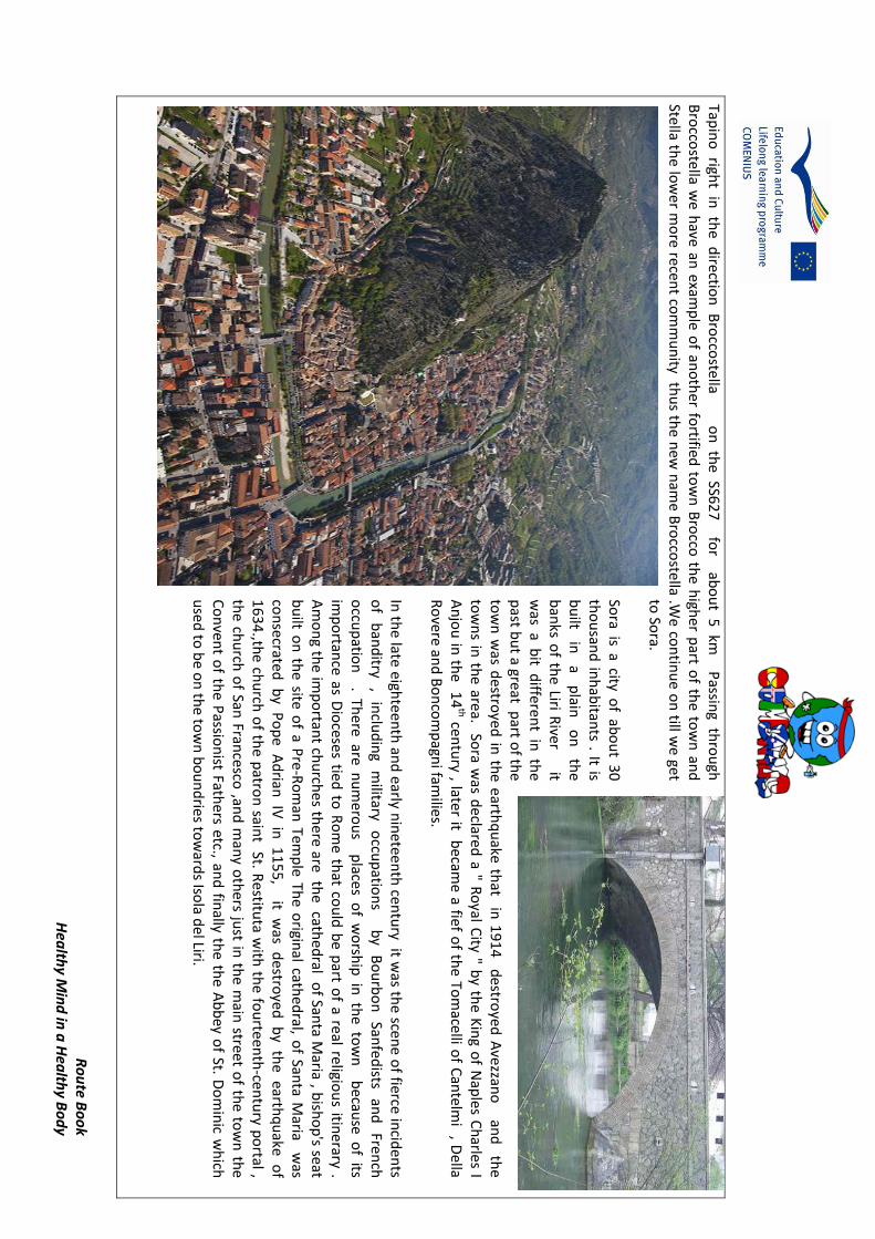
Tapin
o righ
t in th
e directio
n B
rocco
stella on
the
SS62
7
for ab
ou
t 5 km
Passin
g thro
ugh
B
rocco
stella we
have an
examp
le of an
oth
er fortified
tow
n B
rocco
the h
igher p
art of th
e tow
n an
d
Stella the lo
we
r mo
re recent co
mm
un
ity thu
s the n
ew n
ame B
rocco
stella .We
con
tinu
e on
till we get
to So
ra.
Sora is a city o
f abo
ut 30
tho
usan
d in
hab
itants . It is
bu
ilt in
a
plain
o
n
the
ban
ks of th
e Liri River it
was a b
it differen
t in th
e p
ast bu
t a great part o
f the
tow
n w
as destro
yed in
the earth
qu
ake that in
1914
destro
yed A
vezzano
and
the
tow
ns in
the area. So
ra was d
eclared a " R
oyal C
ity " by th
e Kin
g of N
aples C
harles I
An
jou
in th
e 14
th centu
ry , later it becam
e a fief of th
e Tom
acelli of C
antelm
i , Della
Ro
vere and
Bo
nco
mp
agni fam
ilies.
In th
e late eighte
enth
and
early nin
eteenth
centu
ry it was th
e scene o
f fierce incid
ents
of
ban
ditry
, in
clud
ing
military
occu
patio
ns
b
y B
ou
rbo
n
Sanfed
ists an
d
French
o
ccup
ation
. There are n
um
erou
s places o
f wo
rship
in th
e tow
n b
ecause o
f its im
po
rtance as D
ioceses tied
to R
om
e that co
uld
be p
art of a real religio
us itin
erary . A
mo
ng th
e imp
ortan
t chu
rches th
ere are the cath
edral o
f Santa M
aria , bish
op
's seat b
uilt o
n th
e site o
f a Pre
-Ro
man
Temp
le The o
riginal cath
edral, o
f Santa M
aria was
con
secrated b
y Po
pe
Ad
rian IV
in 1
15
5,
it w
as destro
yed b
y the earth
qu
ake o
f 1
63
4.,th
e chu
rch o
f the p
atron
saint St. R
estituta w
ith th
e fou
rteen
th-cen
tury p
ortal ,
the ch
urch
of San
Francesco
,and
man
y oth
ers just in
the m
ain street o
f the to
wn
the
Co
nven
t of th
e Passio
nist Fath
ers etc., and
finally th
e the A
bb
ey of St. D
om
inic w
hich
u
sed to
be o
n th
e tow
n b
ou
nd
ries tow
ards Iso
la del Liri.
Ro
ute
Bo
ok
Hea
lth
y M
ind
in a
Hea
lth
y B
od
y
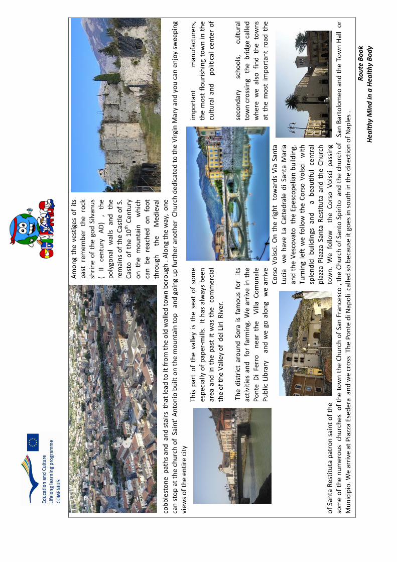
Am
on
g th
e ve
stig
es o
f it
s p
ast
rem
emb
er
the
rock
sh
rin
e o
f th
e go
d S
ilvan
us
( II
cen
tury
A
D)
, th
e
po
lygo
nal
w
alls
an
d
the
rem
ain
s o
f th
e C
astl
e o
f S.
C
asto
o
f th
e 1
0th
Cen
tury
on
th
e m
ou
nta
in
wh
ich
ca
n
be
reac
hed
o
n
foo
t th
rou
gh
the
Med
ieva
l co
bb
lest
on
e p
ath
s an
d a
nd
sta
irs
th
at le
ad t
o it
fro
m t
he
old
wal
led
to
wn
bo
rou
gh .
Alo
ng
the
way
, o
ne
can
sto
p a
t th
e ch
urc
h o
f S
ain
t’ A
nto
nio
bu
ilt o
n t
he
mo
un
tain
to
p
and
go
ing
up
fu
rth
er a
no
ther
Ch
urc
h d
edic
ate
d t
o t
he
Vir
gin
Mar
y an
d y
ou
can
en
joy
swee
pin
g vi
ews
of
the
en
tire
cit
y
This
par
t o
f th
e va
lley
is t
he
seat
of
som
e im
po
rtan
t m
anu
fact
ure
rs,
esp
ecia
lly o
f p
aper
-mill
s.
It h
as a
lway
s b
een
th
e m
ost
flo
uri
shin
g to
wn
in
th
e ar
ea a
nd
in
th
e p
ast
it w
as t
he
co
mm
erci
al
cult
ura
l an
d
po
litic
al c
ente
r o
f th
e o
f th
e V
alle
y o
f d
el L
iri
Riv
er.
Th
e d
istr
ict
aro
un
d S
ora
is
fam
ou
s fo
r i
ts
seco
nd
ary
sch
oo
ls,
cult
ura
l ac
tivi
ties
an
d
for
farm
ing.
We
arri
ve i
n t
he
tow
n c
ross
ing
th
e b
rid
ge c
alle
d
Po
nte
Di
Ferr
o
nea
r th
e V
illa
Co
mu
nal
e w
her
e w
e al
so
fin
d
the
tow
ns
P
ub
lic L
ibra
ry
an
d w
e go
alo
ng
we
arri
ve
at t
he
mo
st i
mp
ort
ant
road
th
e
Co
rso
Vo
lsci
. O
n t
he
righ
t t
ow
ard
s V
ia S
anta
Luci
a w
e h
ave
La C
atte
dra
le d
i Sa
nta
Mar
ia
and
th
e V
esco
vato
th
e Ep
esco
pel
ian
bu
ildin
g.
Turn
ing
left
we
fo
llow
th
e C
ors
o V
ols
ci
wit
h
sple
nd
id
bu
ildin
gs
and
a b
eau
tifu
l ce
ntr
al
pia
zza
Pia
zza
San
ta R
esti
tuta
an
d t
he
Ch
urc
h
of
San
ta R
esti
tuta
pat
ron
sai
nt
of
the
tow
n.
We
follo
w
th
e C
ors
o
Vo
lsci
p
assi
ng
so
me
of
the
nu
mer
ou
s c
hu
rch
es
of
the
tow
n t
he
Ch
urc
h o
f Sa
n F
ran
cesc
o ,
th
e C
hu
rch
of
San
to S
pir
ito
an
d t
he
chu
rch
of
Sa
n B
arto
lom
eo a
nd
th
e To
wn
Hal
l o
r
Mu
nic
ipio
. We
arri
ve a
t P
iazz
a Es
ed
era
an
d w
e cr
oss
Th
e P
on
te d
i Nap
oli
cal
led
so
bec
ause
it g
oes
in s
ou
th in
th
e d
irec
tio
n o
f N
aple
s .
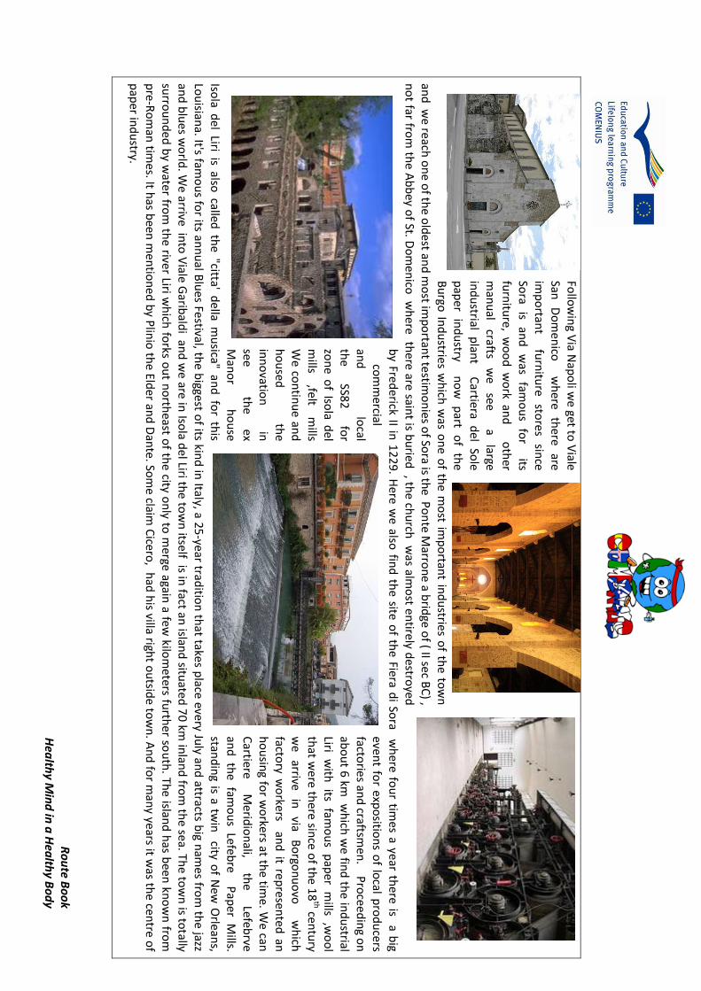
Ro
ute B
oo
k H
ealth
y Min
d in
a H
ealth
y Bo
dy
Follo
win
g Via N
apo
li we
get to V
iale San
D
om
enico
wh
ere th
ere are
imp
ortan
t
furn
iture
stores
since
Sora
is an
d
was
famo
us
for
its
furn
iture, w
oo
d w
ork an
d o
ther
man
ual
crafts w
e
see
a
large in
du
strial plan
t C
artiera del So
le
pap
er in
du
stry
no
w
part
of
the
Bu
rgo In
du
stries wh
ich w
as on
e of th
e mo
st imp
ortan
t ind
ustries o
f the to
wn
an
d w
e re
ach o
ne o
f the o
ldest an
d m
ost im
po
rtant testim
on
ies of So
ra is the P
on
te M
arron
e a brid
ge of ( II sec B
C) ,
no
t far from
the A
bb
ey of St. D
om
enico
wh
ere there are sain
t is bu
ried , th
e chu
rch w
as almo
st entirely d
estroyed
b
y Frederick II in
12
29
. Here w
e also
find
the site o
f the Fiera d
i Sora w
here fo
ur tim
es a year there is a b
ig co
mm
ercial even
t for exp
ositio
ns o
f local p
rod
ucers
and
lo
cal facto
ries and
craftsmen
. Pro
ceed
ing o
n
the
SS82
fo
r ab
ou
t 6 km w
hich
we fin
d th
e ind
ustrial
zon
e of Iso
la del
Liri w
ith
its fam
ou
s p
aper
mills
,wo
ol
mills
,felt m
ills th
at we
re there sin
ce of th
e 18
th centu
ry
We
con
tinu
e and
w
e
arrive in
via
Bo
rgon
uo
vo
w
hich
h
ou
sed
the
factory w
orkers an
d it re
presen
ted
an
inn
ovatio
n
in
ho
usin
g for w
orkers at th
e time. W
e can
see
th
e ex
Cartiere
Merid
ion
ali, th
e
Lefebrve
Man
or
ho
use
and
th
e fam
ou
s Lefebre
P
aper M
ills. Iso
la del Liri is also
called th
e "citta' della m
usica" an
d fo
r this
stand
ing is a tw
in city o
f New
Orlean
s,
Lou
isiana. It's fam
ou
s for its an
nu
al Blu
es Festival, the b
iggest of its kin
d in
Italy, a 25
-year traditio
n th
at takes place every Ju
ly and
attracts big n
ames fro
m th
e jazz
and
blu
es wo
rld. W
e arrive into
Viale G
aribald
i and
we
are in Iso
la del Liri th
e tow
n itse
lf is in fact an
island
situate
d 7
0 km in
land
from
the sea. Th
e tow
n is to
tally su
rrou
nd
ed b
y water fro
m th
e river Liri wh
ich fo
rks ou
t no
rtheast o
f the city o
nly to
merge again
a few kilo
meters fu
rther so
uth
. The islan
d h
as been
kno
wn
from
p
re-Ro
man
times. It h
as been
men
tion
ed b
y Plin
io th
e Elder an
d D
ante. So
me claim
Cicero
, had
his villa righ
t ou
tside to
wn
. An
d fo
r man
y years it was th
e centre o
f p
aper in
du
stry.
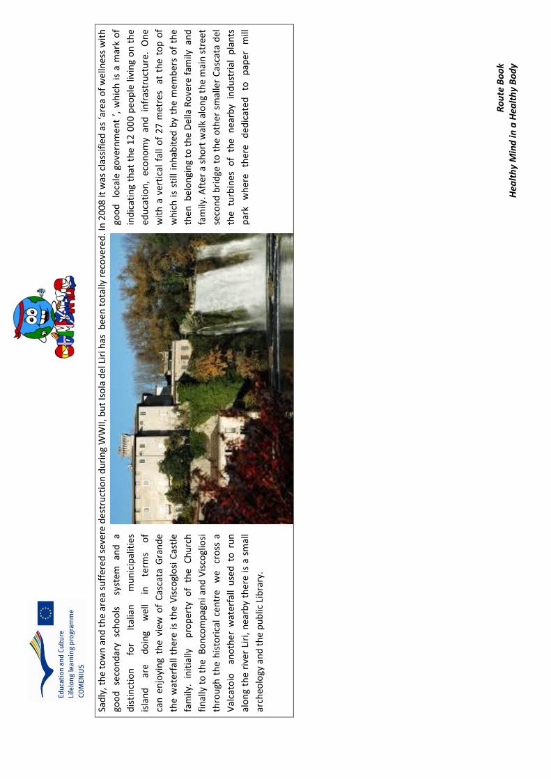
Ro
ute
Bo
ok
Hea
lth
y M
ind
in a
Hea
lth
y B
od
y
Sad
ly, t
he
tow
n a
nd
th
e ar
ea s
uff
ered
sev
ere
des
tru
ctio
n d
uri
ng
WW
II, b
ut
Iso
la d
el L
iri h
as b
een
to
tally
rec
ove
red
. In
20
08
it w
as c
lass
ifie
d a
s ‘a
rea
of
wel
lnes
s w
ith
goo
d
seco
nd
ary
sch
oo
ls
sy
stem
an
d
a go
od
lo
cale
go
vern
men
t ’,
wh
ich
is
a m
ark
of
dis
tin
ctio
n
for
Ital
ian
m
un
icip
alit
ies
ind
icat
ing
that
th
e 1
2 0
00
peo
ple
liv
ing
on
th
e
isla
nd
ar
e d
oin
g w
ell
in
term
s o
f ed
uca
tio
n,
eco
no
my
and
in
fras
tru
ctu
re.
On
e
can
en
joyi
ng
the
view
of
Cas
cata
Gra
nd
e w
ith
a v
erti
cal
fall
of
27
met
res
at
the
top
of
the
wat
erfa
ll th
ere
is t
he
Vis
cogl
osi
Cas
tle
w
hic
h i
s st
ill i
nh
abit
ed b
y th
e m
emb
ers
of
the
fam
ily.
init
ially
pro
per
ty
of
the
Ch
urc
h
then
bel
on
gin
g to
th
e D
ella
Ro
vere
fam
ily a
nd
fin
ally
to
th
e B
on
com
pag
ni a
nd
Vis
cogl
iosi
fa
mily
. Aft
er
a sh
ort
wal
k al
on
g th
e m
ain
str
eet
thro
ugh
th
e h
isto
rica
l ce
ntr
e w
e
cro
ss a
se
con
d b
rid
ge t
o t
he
oth
er s
mal
ler
Cas
cata
del
Val
cato
io
ano
ther
wat
erfa
ll u
sed
to
ru
n
the
turb
ines
o
f th
e
nea
rby
ind
ust
rial
p
lan
ts
alo
ng
the
rive
r Li
ri,
nea
rby
ther
e is
a s
mal
l p
ark
wh
ere
ther
e d
edic
ate
d
to
pap
er
mill
arch
eolo
gy a
nd
th
e p
ub
lic L
ibra
ry.

Ro
ute B
oo
k H
ealth
y Min
d in
a H
ealth
y Bo
dy
PO
INTS O
F INTER
EST ON
THE R
OU
TE
2
3 4
5
6
1

Route Book Healthy Mind in a Healthy Body
POINTS OF INTEREST
Natural Riserve of the Water Park Fibreno Panorama of the Lake Fibreno
Water Mill for the grinding of grain on the Fibreno built in
1810 in the locality of Sorgentina by the Lords Lecce and
Ruggeri. The Mills and dependencies were acquired by
Ferrante family of Alvito in 1851. The mill can be visited as
part of a process of guided tour, booked at the offices of
Riserva Naturale Regionale Lago di Posta Fibreno.
Lake Posta Fibreno offers an opportunity to undertake interesting excursions in a natural, evocative setting, discovering a many-faceted land with bird watching routes, boat excursions , scuba diving lessons, and nature walks
The Central Church of Santa Restituta The Ponte di Napoli on the River Liri
Central church of Sora in the Corso Volsci the main street which derived its name from the Volsci, ancient inhabitants of the town. The saint was martyred in 275 B.C. in Sora by the Romans and is patron saint of the town .
Ponte di Napoli ,Bridge on the River Liri which gives access to the town and leads to the southward direction towards Isola del Liri

Route Book Healthy Mind in a Healthy Body
The Abbey of San Domenico The Cascata Grande ,The large Waterfall
The Abbey of San Domenico with adjacent Benedectine Monastary of the Xth centuty founded in 1011 , By Saint Domenico. Built on the ruins of the Villa of Marco Tullio Cicerone (106 BC 43 BC, ) born in a nearby town of Arpino,where each year the Certamen Ciceronianum brings students from all of Europe to compete in latin translations.
Cascata Grande with a vertical fall of 27 metres from Isola Superiore to the lower part of the town Isola del Liri at the top of the waterfall there is the Viscoglosi Boncompagni Castle.

[Dig
itar
e il
test
o]
Ro
ute
Bo
ok
San
Do
nat
o V
al C
om
ino
– S
ett
efr
ati –
Can
ne
to
CO
UN
TRY
A
REA
LO
CA
TIO
N
RO
UTE
FIL
E
DIS
TAN
CE
TIM
E SU
RFA
VE
SKIL
L LE
VEL
(in
km
) 1
7,4
km
3
7 m
in c
ar
2 h
ou
r w
alk
Mai
nly
pav
ed
-u
np
ave
d
gra
vel)
m
ed
ium
ROUTE
STA
RT
PO
INT
FULL ITENERAY
S
AN
DO
NA
TO
SE
TT
EF
RA
TI
SA
N D
ON
ATO
V.C
.
FIN
ISH
PO
INT
[Digitare il testo
]
Ro
ute B
oo
k
CA
NN
ETO
S
AN
TU
AR
IO M
AR
IA S
S D
I CA
NN
ET
O
MA
P
SUG
GESTIO
NS A
ND
OTH
ER IN
TERESTIN
G D
ATA
Taking fo
od
or w
ater may b
e advisab
le for th
e last part o
f the jo
urn
ey, there
cou
ld b
e d
rinkin
g water availab
le on
the w
ay, taking a rain
coat o
r so
me extra clo
thes m
ight b
e necessary if th
e weath
er is usu
ally chan
geable…
etc.

[Dig
itar
e il
test
o]
Ro
ute
Bo
ok
WA
LK D
ESC
RIP
TIO
N
Ou
r jo
urn
ey b
egin
s in
th
e st
ree
ts o
f Sa
n D
on
ato
Val
di C
om
ino
.
The
ori
gin
s o
f th
is
nu
cleu
s ca
n
be
reco
nn
ecte
d
to
the
his
tory
o
f
Co
min
ium
,
a Su
nn
iti
ou
tpo
st
des
tro
yed
nel
29
3 B
C b
y th
e ar
mie
s o
f
Ro
me,
wh
ich
wo
uld
be
loca
ted
in
th
e
Co
min
o V
alle
y ,
par
ticu
larl
y in
th
e ar
ea
mar
ked
to
day
by
the
tow
ns
of
Alv
ito
,
Vic
alvi
an
d,
of
cou
rse
, Sa
n D
on
ato
.
The
terr
ito
ry
bel
on
ged
to
th
e
Co
min
ese
, f
ollo
win
g th
e Lo
mb
ard
s; s
ub
seq
uen
t ev
ents
are
rel
ate
d t
o t
he
ou
tco
me
of
the
bat
tle
of
Gar
iglia
no
of
91
5,
fro
m w
hic
h
ther
e w
as
mig
rati
on
of
the
peo
ple
s o
f th
ose
ter
rito
rie
s, t
hey
hea
ded
to
war
ds
the
mo
un
tain
s o
n t
he
bo
rder
bet
wee
n L
azio
an
d A
bru
zzo
. It
w
as p
art
of
the
D
uch
y
Alv
ito
an
d f
ollo
we
d t
he
fort
un
es o
f th
is f
eud
al d
om
ain
gra
nte
d t
o
Aq
uin
as,
pas
sed
to t
he
Can
telm
o, t
o C
ard
on
a an
d t
he
galli
um
to
be
tran
sfer
red
to
the
Stat
e ,
and
fin
ally
,
in
18
06
, i
t w
as f
inal
ly
rele
ased
fr
om
the
feu
dal
se
rfd
om
. Sa
n
Do
nat
o is
div
ided
into
tw
o
area
s.
The
hig
hes
t p
art
of
the
tow
n i
s kn
ow
n a
s th
e C
astl
e,
still
su
rro
un
ded
by
a ci
rcle
of
wal
ls :
th
ere
are
thre
e d
oo
rs,
and
tr
aces
o
f th
e
tow
ers
of
the
cast
le ,
th
ere
are
the
ruin
s o
f th
e h
igh
to
wer
-
wh
ile
the
wal
ls
of
the
fort
ress
w
ere
in
corp
ora
ted
in
to
the
new
ho
use
s. T
he
area
is
char
acte
rize
d
by
nar
row
, w
ind
ing
stre
ets
and
al
leys
,
oft
en
rin
g-sh
aped
an
d
con
cen
tric
u
p
to
the
fort
ress
, st
ill p
aved
wit
h
loca
l st
on
e.
In
the
seco
nd
ar
ea
,
ther
e a
re
new
bu
ildin
gs.
The
tow
n
ce
nte
r is
ch
arac
teri
zed
b
y
seve
ral
wo
rks
in l
imes
ton
e w
ork
ed
by
loca
l st
on
emas
on
s
wh
o b
uilt
ble
ach
ers,
bar
oq
ue
po
rtal
s , d
eco
rati
ve f
riez
es ,
key
segm
ents
w
ith
co
ats
of
arm
s an
d h
eral
dic
fig
ure
s. W
alki
ng
thro
ugh
th
e n
arro
w s
tree
ts t
o t
he
valle
y yo
u g
et t
o t
he
hig
hes
t p
art
of
the
villa
ge w
ith
th
e Sa
nct
uar
y an
d t
he
Tow
er
The
San
ctu
ary
of
San
Do
nat
o V
al d
i Co
min
o T
he
san
ctu
ary
was
ere
cte
d a
s a
smal
l Ben
edic
tin
e A
bb
ey
fro
m t
he
Ab
bey
of
Mo
nte
cass
ino
. Th
e fi
rst
do
cum
ent
in w
hic
h it

[Digitare il testo
]
Ro
ute B
oo
k
is nam
ed in
77
8 A
D , th
e year in w
hich
the D
uke
of Sp
oleto
, Hild
ebran
d, gave th
e chu
rch an
d th
e area of San
Do
nato
to th
e Mo
naste
ry of San
Vin
cenzo
al Vo
lturn
o.
The o
riginal " aecclesia " th
ere are no
traces , since n
um
erou
s chan
ges and
reno
vation
s have b
rou
ght to
its presen
t shrin
e . The san
ctuary is co
mp
osed
of th
ree
naves , th
e central o
ne co
ntain
s frescoes rep
resentin
g the m
ost sign
ificant m
om
ents o
f the h
oly life. In
185
9 w
ork b
egan o
n th
e con
structio
n o
f the b
ell tow
er
adjacen
t , 17
meters h
igh , an
d w
ere co
mp
leted
in
192
1.
In 1
91
5, th
e last restoratio
n w
as carried o
ut o
f the
sanctu
ary by th
e Fiorin
i Sora , led
by C
ano
n Lu
igi Ipp
oliti ,
creator o
f the p
op
ular d
edicate
d to
St. Do
nato
, Bish
op
an
d M
artyr. The San
ctuary, h
as bee
n rece
ntly resto
red,
makin
g a reinvigo
ration
of th
e colo
rs of th
e frescoes
and
in
terio
r d
ecoratio
n.
The
Med
ieval to
we
r ,
size
5.4
0x5
.40x1
2
high
, is
isolate
d
from
th
e rem
ainin
g h
om
es and
stand
s at the h
ighest p
oin
t of th
e village.
Bu
ilt on
a rocky o
utcro
p , it allo
ws a view
of a large
part o
f the C
om
ino
Valley an
d th
e surro
un
din
g area.
There is n
o access to
the to
wer fro
m th
e grou
nd
floo
r Th
e locatio
n, size an
d lo
cation
of th
e ob
servation
po
ints
make it an
auto
no
mo
us b
od
y used
to co
ntro
l the p
ass o
f Forca d
'Acero
, also o
ffering , in
the p
ast, a su
re
defe
nse to
tho
se wh
o " live
d it Th
e tow
er of San
D
on
ato , b
uilt an
d o
riented
accord
ing to
the d
eclinatio
n
of th
e sun
as if it we
re a com
pass, in
dicatin
g the fo
ur
cardin
al p
oin
ts, th
e lo
cation
o
f th
e A
bb
ey o
f
Mo
ntecassin
o an
d th
e po
sition
of th
e Sun
on
the d
ay of th
e Equ
ino
xes and
Solstices. C
on
tinu
ing alo
ng o
ur p
aths w
e fin
d Th
e min
es of San
Do
nato
Val d
i
Co
min
o. In
17
74
, the m
ou
ntain
s of th
e Valle d
i Co
min
o w
as fou
nd
a large qu
antity o
f raw m
aterials.In
tho
se years , on
the slo
pes o
f Mo
nt M
eta, was d
iscovered
rock rich
in iro
n o
xide , as a resu
lt of th
e excavation
s we
re carried o
ut. In
18
52
, Kin
g Ferdin
and
II of B
ou
rbo
n, p
oten
tiated th
e min
ing research
, in o
rder to
fill the
nee
ds o
f raw m
aterials and
metals in
the artillery facto
ries In th
e sprin
g of 1
85
2 , a
com
mittee
of
techn
icians,
fou
nd
in
th
e mo
un
tains
large am
ou
nts
of
limo
nite
(
iron
sesqu
ioxid
e ) and
bau
xite
. On
ce it
was
extracted
the m
aterial w
as bro
ugh
t
in
( C
apo
lavalle ),
the
curren
t P
iazza C
arlo
Co
letti, th
anks
to
the
baske
ts th
at w
ere
transp
orted
fro
m
qu
adru
ped
s. Wo
men
also
particip
ated
in
th
e

[Dig
itar
e il
test
o]
Ro
ute
Bo
ok
tran
spo
rt o
f m
iner
als
, lim
on
ite
in w
icke
r b
aske
ts.A
s so
on
as
the
mat
eri
al a
rriv
ed in
th
e sq
uar
e, it
was
we
igh
ed a
nd
pai
d t
o t
he
wo
rker
s an
d t
hen
was
tra
nsp
ort
ed
to t
he
" fo
un
dry
"
in A
tin
a w
her
e i
t w
as
tran
sfo
rmed
. T
he
raw
mat
eri
als
we
re m
ined
un
til
18
60
. Fo
llow
ing
the
un
ific
atio
n o
f It
aly
, an
d t
he
min
es ,
th
at
the
" fo
un
dry
" o
f A
tin
a, w
ere
fin
ally
ab
and
on
ed.
La T
orr
e d
ei T
edes
chi,
the
Ge
rman
’s R
ock
, a
sp
ike
that
sta
nd
s o
ut
fro
m t
he
sid
es o
f M
ou
nt
Piz
zutt
o (
the
mo
un
tain
th
at r
ises
ab
ove
San
Do
nat
o )
, i
t w
as a
mili
tary
ou
tpo
st
use
d b
y th
e G
erm
an a
rmy
in r
etre
at d
uri
ng
the
Seco
nd
Wo
rld
War
in
anti
cip
atio
n o
f a
def
eat
exp
erie
nce
on
th
e
war
fro
nt
of
Cas
sin
o ,
alo
ng
the
Gu
stav
Lin
e. W
ith
th
e la
nd
ing
at A
nzi
o
and
th
e fa
ll o
f C
assi
no
Fr
on
t ,
Ger
man
tr
oo
ps
beg
an
thei
r re
trea
t to
R
om
e,
usi
ng
the
V
ia
Cas
ilin
a.
New
Zeal
and
tr
oo
ps
arri
ved
to
h
elp
In
th
e C
om
ino
Val
ley
, an
d l
uck
ily a
fter
ab
ou
t 1
0 d
ays,
th
e G
erm
ans
beg
an t
o
retr
eat
n
ort
hw
ard
, le
avin
g w
eap
on
s,
amm
un
itio
n a
nd
fu
rnis
hin
gs.
In t
he
cen
ter
of
the
rock
alo
ng
a fr
actu
re ,
ther
e is
a c
her
ry t
ree
, p
lan
ted
th
ere
in
m
emo
ry o
f th
ose
so
ldie
rs.
The
pla
ce c
an b
e re
ach
ed t
hro
ugh
a r
ou
te
mad
e b
y th
e C
AI
Cen
tro
Alp
ino
Ita
lian
o o
f Sa
n D
on
ato
Set
tefr
ati
The
nam
e o
f th
e to
wn
co
mes
fro
m t
he
Ho
ly S
even
Bro
ther
s c
hild
ren
of
San
ta F
elic
ita
,
sist
er o
f Sa
int
Ben
idic
t S
he
was
m
arty
red
wit
h h
is m
oth
er d
uri
ng
the
per
secu
tio
n o
f
Ch
rist
ian
s in
th
e R
om
an E
mp
ire
. Th
e co
nst
ruct
ion
s o
f th
e vi
llage
dat
es,
bac
k to
VII
I th
and
XIX
th
cen
turi
es in
th
eir
curr
ent
form
, m
any
of
the
bu
ildin
gs s
till
hav
e th
e o
rigi
nal
med
ieva
l st
ruct
ure
s .T
her
e ar
e
rem
ain
s o
f ra
mp
arts
an
d a
to
we
r o
f
the
XII
an
d
XII
I th
. ce
ntu
ries
a
s w
ell
as
the
rem
ain
s o
f m
aso
nry
fr
on
t ,
per
hap
s ev
en
of
pre
-Ro
man
ti
mes
.
The
cast
le
of
Sett
efra
ti
,
of
wh
ich
ther
e ar
e th
e re
mai
ns
of
the
tow
er
and
sca
tter
ed r
emai
ns
of
wal
ls, i
s d
ocu
men
ted
fro
m t
he
ten
th c
entu
ry
Of
grea
t im
po
rtan
ce i
s th
e C
hu
rch
of
Ou
r La
dy
of
Gra
ces
¬ ,
of
X t
h c
entu
ry
, w
ith
car
ved
an
d g
ilded
co
ffer
ed
ceili
ng
wit
h a
triu
m d
epic
tin
g th
e vi
sio
n o
f F
iar
Uld
eric
o (
vis
ion
th
at w
ou
ld h
ave
give
n t
he
insp
irat
ion
fo
r D
ante
's
"Div
ine
Co
med
y "
) an
d t
he
inte
rio
r p
ain
tin
gso
f gr
eat
pre
stig
e.
The
Ch
urc
h o
f th
e M
ado
nn
a d
elle
Gra
zie
, w
hic
h
ho
use
s a
fres
co in
th
e ve
stib
ule
rep
rese
nti
ng
the
Last
Ju
dgm
ent
and
, in
sid
e , a
n e
igh
teen
th-c
entu
ry c
off
ered
cei
ling
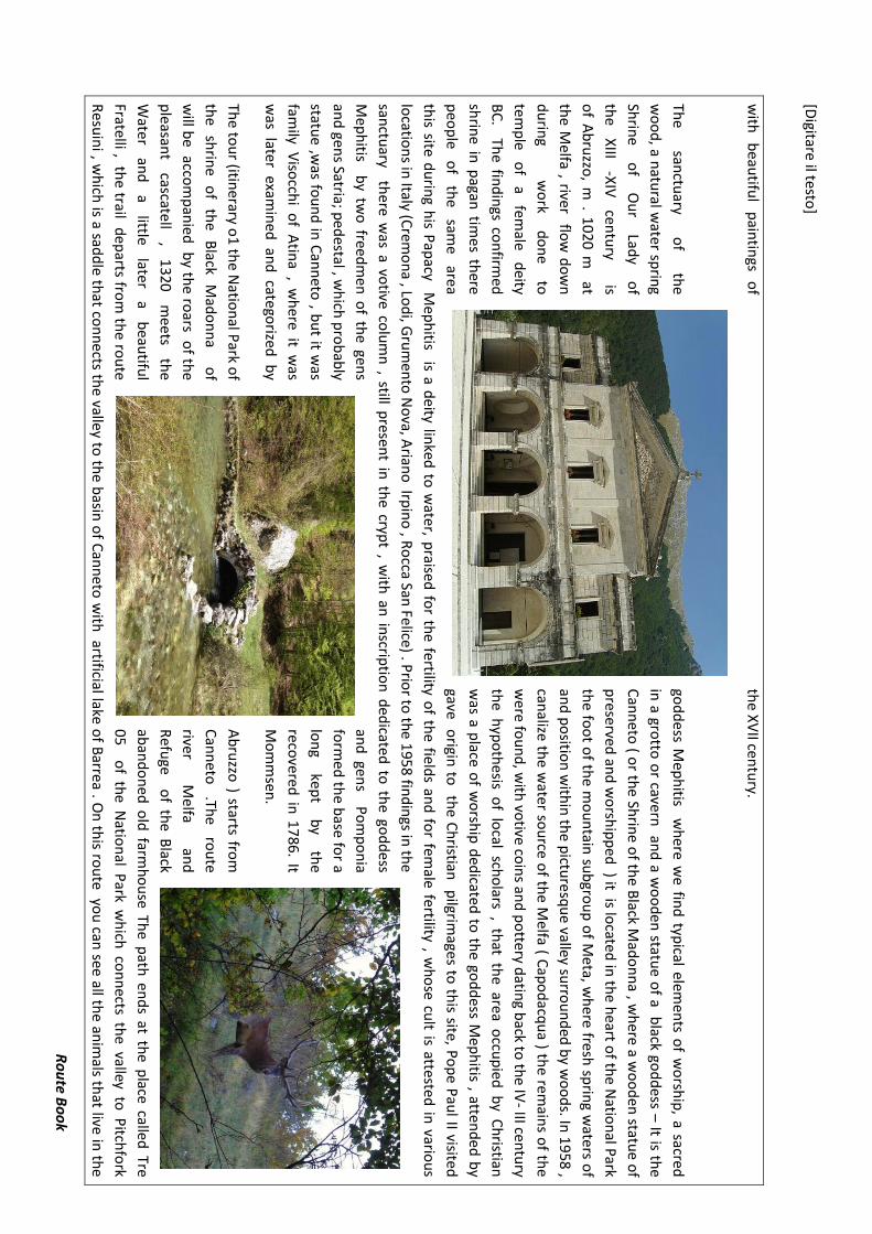
[Digitare il testo
]
Ro
ute B
oo
k
with
b
eautifu
l p
aintin
gs o
f th
e XV
II centu
ry.
The
sanctu
ary o
f th
e go
dd
ess Mep
hitis w
here w
e fin
d typ
ical elemen
ts of w
orsh
ip, a sacred
wo
od
, a natu
ral water sp
ring
in a gro
tto o
r cavern an
d a w
oo
den
statue o
f a black go
dd
ess – It is the
Shrin
e o
f O
ur
Lady
of
Can
neto
( or th
e Shrin
e of th
e Black M
ado
nn
a , wh
ere a wo
od
en statu
e of
the
XIII
-XIV
cen
tury
is
prese
rved an
d w
orsh
ipp
ed ) it is lo
cated
in th
e heart o
f the N
ation
al Park
of A
bru
zzo, m
. 10
20
m at
the fo
ot o
f the m
ou
ntain
sub
grou
p o
f Meta, w
here fresh
sprin
g waters o
f
the M
elfa , river flow
do
wn
an
d p
ositio
n w
ithin
the p
icture
squ
e valley surro
un
ded
by w
oo
ds. In
19
58 ,
du
ring
w
ork
do
ne
to
canalize th
e water so
urce o
f the M
elfa ( Cap
od
acqu
a ) the rem
ains o
f the
tem
ple
of
a fem
ale d
eity w
ere fo
un
d, w
ith vo
tive coin
s and
po
ttery datin
g back to
the IV
- III centu
ry
BC
. The fin
din
gs con
firmed
th
e hyp
oth
esis of lo
cal scho
lars , that th
e area occu
pied
by C
hristian
shrin
e in p
agan tim
es there
was a p
lace of w
orsh
ip d
edicated
to th
e god
dess M
eph
itis , attend
ed b
y
peo
ple
of
the
same
area gave o
rigin to
the C
hristian
pilgrim
ages to th
is site, Po
pe P
aul II visited
this site d
urin
g his P
apacy M
eph
itis is a deity lin
ked to
water, p
raised fo
r the fertility o
f the field
s and
for fem
ale fertility , wh
ose cu
lt is attested
in vario
us
locatio
ns in
Italy (Crem
on
a , Lod
i, Gru
men
to N
ova, A
riano
Irpin
o , R
occa San
Felice) . Prio
r to th
e 195
8 fin
din
gs in th
e
sanctu
ary there w
as a votive co
lum
n , still p
resent in
the cryp
t , with
an in
scriptio
n d
edicate
d to
the go
dd
ess
Mep
hitis b
y two
freedm
en o
f the gen
s an
d gen
s Po
mp
on
ia
and
gens Satria; p
edestal , w
hich
pro
bab
ly fo
rmed
the b
ase for a
statue ,w
as fou
nd
in C
ann
eto , b
ut it w
as lo
ng
kep
t b
y th
e
family V
isocch
i of A
tina , w
here it w
as reco
vered in
1786
. It
was later exam
ined
and
catego
rized b
y M
om
msen
.
The to
ur (itin
erary o1 th
e Natio
nal P
ark of
Ab
ruzzo
) starts from
the
shrin
e o
f th
e B
lack M
ado
nn
a
of
Can
neto
.Th
e ro
ute
will b
e accom
pan
ied b
y the ro
ars of th
e rive
r M
elfa an
d
pleasan
t cascate
ll ,
13
20
mee
ts th
e R
efuge o
f the B
lack
Wate
r an
d
a little
later a
beau
tiful
aban
do
ned
old
farmh
ou
se The p
ath en
ds at th
e place called
Tre
Fratelli , th
e trail dep
arts from
the ro
ute
05
of th
e Natio
nal P
ark wh
ich co
nn
ects the valley to
Pitch
fork
Resu
ini , w
hich
is a sadd
le that co
nn
ects the valley to
the b
asin o
f Can
neto
with
artificial lake o
f Barrea . O
n th
is rou
te yo
u can
see all the an
imals th
at live in th
e
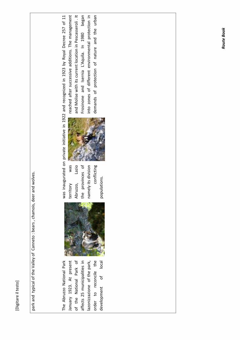
[Dig
itar
e il
test
o]
Ro
ute
Bo
ok
par
k an
d t
ypic
al o
f th
e V
alle
y o
f C
ann
eto
: b
ears
, ch
amo
is, d
eer
and
wo
lves
.
The
Ab
ruzz
o N
atio
nal
Par
k w
as i
nau
gura
ted
on
pri
vate
in
itia
tive
in
19
22
an
d r
eco
gniz
ed i
n 1
92
3 b
y R
oya
l D
ecre
e 2
57
of
11
Jan
uar
y 1
923
. A
t p
rese
nt
terr
ito
ry
was
re
ach
ed a
fter
su
cces
sive
ad
dit
ion
s. T
he
man
agem
ent
of
the
Nat
ion
al
Par
k o
f A
bru
zzo
, La
zio
an
d M
olis
e w
ith
its
curr
ent
loca
tio
n in
Pes
cass
ero
li .
It
affe
cts
25 m
un
icip
alit
ies
in
the
pro
vin
ces
of
Fro
sin
on
e an
d
Iser
nia
L'
Aq
uila
. In
1
98
0
b
egan
lazo
niz
zazi
on
e o
f th
e p
ark,
n
amel
y it
s d
ivis
ion
in
to z
on
es o
f d
iffe
ren
t en
viro
nm
enta
l p
rote
ctio
n i
n
ord
er
to
reco
nci
le
the
con
flic
tin
g d
eman
ds
of
pro
tect
ion
o
f n
atu
re
and
th
e u
rban
dev
elo
pm
ent
of
loca
l p
op
ula
tio
ns.

[Digitare il testo
]
Ro
ute B
oo
k
1
2
3 4

[Digitare il testo]
Route Book
POINTS OF INTEREST Panorama of San Donato
Medieval village in the southern end of the Parco Nazionale d'Abruzzo Lazio and Molise-in the old town consists of narrow streets, stairs, gates and towers. Of particular interest are the Museum of civilization and the Geological Museum
Center medieval fortress with defensive function, containing many remains of ancient structuresand wonderful panoramic view The constructions of the village dates, back to VIII th and XIX th centuries in their current form , many of the buildings still have the original implant.
A Monument to Don Bosco Ancient Sanctuary of the Madonna of Canneto
John Melchior Bosco, better known as Don Bosco, was the founder of the congregations of the Salesians and the Daughters of Mary Help of Christians. He was canonized by Pope Pius XI in 1934, It is a meeting place for excursions and summer camps for young people.
The shrine dedicated to St. Mary is located at about 1000 m / asl. In pre-Roman times was a place of worship of the goddess Mefiti for the
presence of the source of the River Melfa. Numerous walking trails that start from this
location

Ro
ute B
oo
k H
ealth
y Min
d in
a H
ealth
y Bo
dy
Cassin
o - M
on
tecassino
CO
UN
TRY
A
REA
LO
CA
TION
RO
UTE FILE
DISTA
NC
E TIM
E SU
RFA
VE
SKILL LEV
EL

Ro
ute
Bo
ok
Hea
lth
y M
ind
in a
Hea
lth
y B
od
y
me
diu
m
ROUTE
STA
RT
PO
INT
FULL ITENERAY
Rai
lway
sta
tio
n -
Pia
zza
Giu
sep
pe
Gar
ibal
di
Via
le D
ante
,V
illa
Co
mu
nal
e t
ake
the
Bu
s N
° 1
6 w
hic
h w
ill b
rin
g u
s u
pw
ard
s to
MO
NT
EC
ASS
INO
Po
lish
War
Cem
eter
y, b
us
N°
16
in o
pp
osi
te d
irec
tio
n
Co
loss
eo, H
isto
rial
e, C
AM
USA
C
Mo
der
n a
rt M
use
um
, Rai
lway
Sta
tio
n
CA
SSIN
O T
RA
IN
STA
TIO
N
FIN
ISH
PO
INT
CA
SSIN
O T
RA
IN
STA
TIO
N
MA
P

Ro
ute B
oo
k H
ealth
y Min
d in
a H
ealth
y Bo
dy
SUG
GESTIO
NS A
ND
OTH
ER IN
TERESTIN
G D
ATA
WA
LK D
ESCR
IPTIO
N

Ro
ute
Bo
ok
Hea
lth
y M
ind
in a
Hea
lth
y B
od
y
Cas
sin
o is
a m
un
icip
alit
y in
th
e p
rovi
nce
of
Fro
sin
on
e, I
taly
, at
the
sou
ther
n e
nd
of
the
regi
on
of
Lazi
o.
It i
s lo
cate
d a
t th
e fo
ot
of
Mo
nte
Cai
ro n
ear
the
con
flu
ence
of
the
Gar
i an
d L
iri r
ive
rs. T
he
city
is b
est
kno
wn
as
the
site
of
the
Ab
bey
of
Mo
nte
cass
ino
an
d t
he
Bat
tle
of
Mo
nte
Cas
sin
o d
uri
ng
Wo
rld
War
II,
wh
ich
res
ult
ed in
trem
end
ou
s A
llied
an
d G
erm
an c
asu
alti
es a
s w
ell
as t
he
nea
r to
tal
des
tru
ctio
n o
f th
e to
wn
its
elf.
It
is a
lso
im
po
rtan
t b
ecau
se S
ain
t B
enid
ict
is t
he
fou
nd
er o
f th
e
Ben
edic
tin
e Fr
iars
an
d
the
P
atro
n
Sain
t Sa
int
of
the
Euro
pea
n
Un
ion
. To
day
, C
assi
no
is
al
so
ho
me
to
the
Un
ive
rsit
y o
f C
assi
no
an
d
a FI
AT
auto
mo
tive
p
lan
t.
Cas
sin
o's
ori
gin
s lie
in
th
e V
ols
can
set
tlem
ent
of
Cas
inu
m,
site
d
ato
p
the
hill
o
f C
assi
no
n
ear
Mo
nte
C
airo
, fi
ve
kilo
met
res
to t
he
no
rth
. Cas
inu
m p
asse
d u
nd
er t
he
con
tro
l
of
the
Sam
nit
es,
bu
t th
e R
om
ans
even
tual
ly g
ain
ed c
on
tro
l
of
Cas
inu
m,
esta
blis
hin
g a
fort
ifie
d c
olo
ny
ther
e in
31
2 B
C.
At
leas
t o
nce
du
rin
g P
un
ic W
ars,
Han
nib
al p
asse
d n
ear
Cas
inu
m.
Cas
inu
m w
as a
lso
th
e si
te o
f a
villa
pre
sum
ed t
o
bel
on
g to
M
arcu
s Te
ren
tiu
s V
arro
. Th
e m
od
ern
to
wn
wh
ich
aro
se o
n t
he
site
of
the
anci
ent
tow
n o
f C
asin
um
was
cal
led
San
Ger
man
o,
bu
t o
n 2
8 J
uly
18
63
th
e n
ame
was
off
icia
lly r
ever
ted
to
"C
assi
no
". D
uri
ng
the
ren
aiss
ance
Cas
sin
o l
ay o
n t
he
no
rth
ern
fro
nti
er o
f th
e K
ingd
om
of
Nap
les,
wh
ich
was
do
min
ate
d b
y Sp
ain
. In
150
4,
du
rin
g th
e Se
con
d I
talia
n W
ar,
Fran
ce a
ttem
pte
d t
o c
aptu
re t
he
tow
n in
th
e B
attl
e o
f C
assi
no
, b
ut
faile
d.
The
dep
end
ence
of
Cas
sin
o o
n S
pai
n l
aste
d u
nti
l 1
86
0.
Aft
er w
orl
d W
ar I
I Th
e to
wn
w
as
reb
uilt
sou
th-e
ast
of
its
pri
or
loca
tio
n i
n a
rel
ativ
ely
sho
rt t
ime.
Bec
ause
of
this
, th
e to
wn
has
a
som
ewh
at
dis
ord
erly
ro
ad n
etw
ork
.
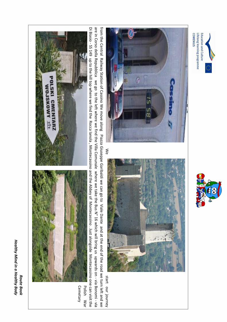
Ro
ute B
oo
k H
ealth
y Min
d in
a H
ealth
y Bo
dy
W
e start o
ur jo
urn
ey
from
the C
entral R
ailway Statio
n o
f Cassin
o W
e m
ove alo
ng P
iazza Giu
sepp
e Garib
aldi w
e can
go to
Viale D
ante an
d at th
e end
of th
e road
we tu
rn left an
d w
e
are in C
orso
della R
epu
bb
lica we go
to th
e left wh
ere we fin
d th
e Villa C
om
un
ale wh
ere we take th
e Bu
s N° 1
6 wh
ich w
ill brin
g us u
pw
ards o
n - via B
on
om
i - via
Di B
iasio - SS 1
49 u
p to
the h
ill top
wh
ere we fin
d th
e Ro
cca Iano
la , Mo
ntecassin
o an
d th
e Ab
bey o
f Mo
ntecassin
o . Ju
st alon
gside M
on
tecassin
o o
ne can
visit the
Po
lish
War
Cem
etary

Ro
ute
Bo
ok
Hea
lth
y M
ind
in a
Hea
lth
y B
od
y
The
Po
lish
cem
ete
ry a
t M
on
te C
assi
no
co
nta
ins
grav
es o
f m
ore
th
an o
ne
tho
usa
nd
Po
les
wh
o d
ied
wh
ile s
torm
ing
the
abb
ey in
May
19
44
, du
rin
g th
e B
attl
e o
f M
on
te C
assi
no
. Th
e re
ligio
us
affi
liati
on
of
the
dea
d m
en is
mar
ked
by
each
gra
ve h
avin
g o
ne
of
thre
e d
iffe
ren
t ty
pes
of
hea
dst
on
e: t
he
Cat
ho
lic a
nd
Ort
ho
do
x h
ead
sto
nes
are
dis
tin
guis
hed
fro
m e
ach
oth
er b
y d
iffe
ren
t fo
rms
of
cro
ss, w
hile
th
e Je
wis
h h
ead
sto
nes
bea
r th
e St
ar o
f D
avid
. Th
e ce
met
ery
also
co
nta
ins
the
grav
e o
f G
ener
al A
nd
ers,
co
mm
and
er o
f th
e P
olis
h f
orc
es, w
ho
su
rviv
ed t
he
war
, dyi
ng
in L
on
do
n in
19
70
.Par
t o
f th
e P
olis
h m
emo
rial
at
Mo
nte
Cas
sin
o b
ears
th
e fo
llow
ing
insc
rip
tio
n, w
hic
h t
ran
slat
ed f
rom
Po
lish
rea
ds: W
e P
olis
h s
old
iers
Fo
r o
ur
fre
ed
om
an
d y
ou
rs H
ave
give
n o
ur
sou
ls t
o G
od
Ou
r b
od
ies
to t
he
soil
of
Ital
y an
d o
ur
hea
rts
to P
ola
nd
We
take
th
e b
us
in t
he
op
po
site
to
th
e to
wn
Cen
tre
and
we
can
vis
it t
he
area
cal
led
il C
olo
ssse
o. T
he
Co
loss
eum
, or
amp
hit
hea
ter,
is t
he
mo
st r
epre
sen
tati
ve o
f th
e
Ro
man
arc
hae
olo
gica
l el
emen
t o
f C
assi
no
. Th
ere
is l
ittl
e le
ft,
per
imet
er w
alls
an
d a
few
str
oke
s o
f th
e in
tern
al s
tru
ctu
re,
bu
t th
ey'r
e st
ill a
cle
ar a
nd
elo
qu
ent
test
imo
ny
to t
he
gran
deu
r, m
ajes
ty,
the
mag
nif
icen
ce o
f th
e R
om
an c
ivili
zati
on
. T
o t
he
wes
t o
f th
e C
olo
sseu
m,
wit
hin
th
e w
alls
of
the
Cas
inu
m,
we
can
see
th
e
Ro
man
Th
eatr
e o
f w
hic
h y
ou
can
ad
mir
e th
e re
mai
ns
of
sub
stan
tial
str
uct
ura
l co
mp
lex,
i
t is
sti
ll u
sed
fo
r p
erfo
rman
ces
and
eve
nts
of
vari
ou
s ki
nd
s.
Ret
urn
ing
tow
ard
s th
e ra
ilway
sta
tio
n
we
can
go
to
th
e H
isto
rial
e
inte
ract
ive
war
Mu
seu
m
it is
20
0 m
fro
m t
he
trai
n s
tati
on
fr
om
Pia
zzaG
arib
ald
i .
We
turn
le
ft
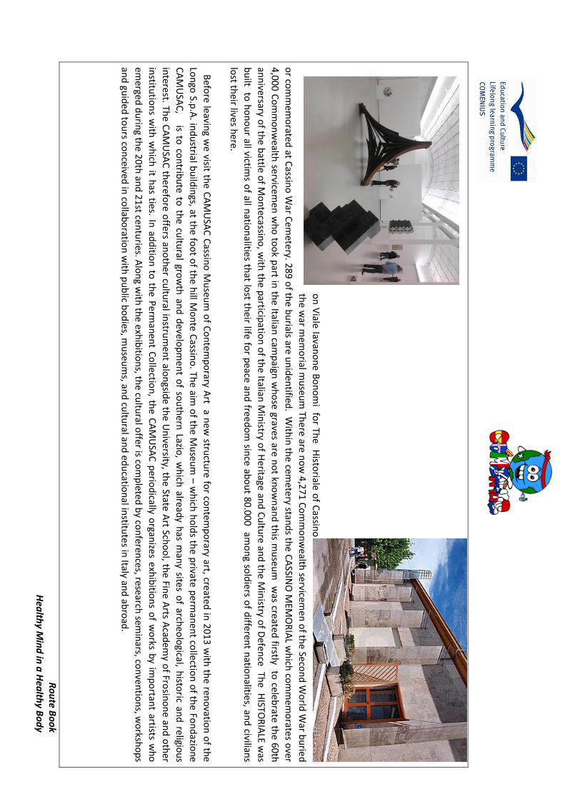
Ro
ute B
oo
k H
ealth
y Min
d in
a H
ealth
y Bo
dy
on
Viale Iavan
on
e Bo
no
mi fo
r The H
istoriale o
f Cassin
o
the w
ar mem
orial m
useu
m Th
ere are no
w 4
,271
Co
mm
on
we
alth servicem
en o
f the Seco
nd
Wo
rld W
ar bu
ried
or co
mm
emo
rated
at Cassin
o W
ar Cem
etery. 2
89
of th
e bu
rials are un
iden
tified. W
ithin
the cem
etery stand
s the C
ASSIN
O M
EMO
RIA
L wh
ich co
mm
emo
rates over
4,00
0 C
om
mo
nw
ealth
servicemen
wh
o to
ok p
art in th
e Italian cam
paign
wh
ose grave
s are no
t kno
wn
and
this m
useu
m w
as created firstly to
celebrate th
e 60th
ann
iversary o
f the b
attle of M
on
tecassino
, with
the p
articipatio
n o
f the Italian
Min
istry of H
eritage and
Cu
lture an
d th
e Min
istry of D
efence Th
e HISTO
RIA
LE was
bu
ilt to h
on
ou
r all victims o
f all natio
nalities th
at lost th
eir life for p
eace an
d free
do
m sin
ce abo
ut 80
.000 am
on
g sold
iers of d
ifferent n
ation
alities, and
civilians
lost th
eir lives here.
Befo
re leaving w
e visit th
e CA
MU
SAC
Cassin
o M
useu
m o
f Co
ntem
po
rary Art a n
ew stru
cture fo
r con
temp
orary art, created
in 2
013
with
the ren
ovatio
n o
f the
Lon
go S.p
.A. in
du
strial bu
ildin
gs, at the fo
ot o
f the h
ill Mo
nte
Cassin
o. Th
e aim o
f the M
useu
m –
wh
ich h
old
s the p
rivate p
erman
ent co
llection
of th
e Fon
dazio
ne
CA
MU
SAC
, is to co
ntrib
ute
to th
e cultu
ral grow
th an
d d
evelop
men
t of so
uth
ern Lazio
, wh
ich alread
y has m
any sites o
f archeo
logical, h
istoric an
d religio
us
inte
rest. The C
AM
USA
C th
erefore o
ffers ano
ther cu
ltural in
strum
ent alo
ngsid
e the U
nive
rsity, the State A
rt Scho
ol, th
e Fine A
rts Acad
emy o
f Frosin
on
e and
oth
er
institu
tion
s with
wh
ich it h
as ties. In ad
ditio
n to
the P
erman
ent C
ollectio
n, th
e CA
MU
SAC
perio
dically o
rganizes exh
ibitio
ns o
f wo
rks by im
po
rtant artists w
ho
emerged
du
ring th
e 20
th an
d 2
1st cen
turies. A
lon
g with
the exh
ibitio
ns, th
e cultu
ral offer is co
mp
leted b
y con
ferences, research
semin
ars, con
ventio
ns, w
orksh
op
s
and
guid
ed to
urs co
nceived
in co
llabo
ration
with
pu
blic b
od
ies, mu
seum
s, and
cultu
ral and
ed
ucatio
nal in
stitute
s in Italy an
d ab
road
.

Ro
ute
Bo
ok
Hea
lth
y M
ind
in a
Hea
lth
y B
od
y
Extr
a N
ote
s
The
Ab
bey
on
Mo
nte
Cas
sin
o w
as o
rigi
nal
ly f
ou
nd
ed b
y Sa
int
Ben
edic
t in
52
9,
mak
ing
it o
ne
of
Euro
pe'
s o
ldes
t m
on
aste
ries
. Th
e a
bb
ey w
as b
uilt
on
rem
nan
ts o
f
Ro
man
fo
rtif
icat
ion
s n
ear
the
Tem
ple
of
Ap
ollo
. Th
e m
on
aste
ry b
ecam
e kn
ow
n a
s a
cen
ter
of
cult
ure
an
d a
rt.
The
entr
ance
clo
iste
r w
as t
he
site
of
the
tem
ple
of
Ap
ollo
, mad
e in
to a
n o
rato
ry b
y Sa
int
Ben
edic
t. N
ext
gues
ts e
nte
r B
ram
ante
clo
iste
r, a
bu
ilt in
15
95
. I
n t
he
cen
ter
is a
n o
ctag
on
al w
ell
and
fro
m t
he
bal
con
y th
ere
are
grea
t vi
ews
of
the
valle
y. A
t th
e b
ott
om
of
the
stai
rcas
e is
a s
tatu
e o
f Sa
int
Ben
edic
t, d
atin
g fr
om
17
36
an
d n
ot
des
tro
yed
in
th
e b
om
bin
g. A
t th
e b
asili
ca
entr
ance
are
th
ree
bro
nze
do
ors
, th
e m
idd
le o
ne
dat
ing
fro
m t
he
11
th c
entu
ry.
Insi
de
the
bas
ilica
are
am
azin
g fr
esco
es a
nd
mo
saic
s. T
he
Ch
apel
of
Rel
ics
ho
lds
reliq
uar
ies
of
seve
ral
sain
ts.
Do
wn
stai
rs i
s th
e cr
ypt,
bu
ilt i
n 1
54
4 a
nd
car
ved
in
to t
he
mo
un
tain
. Th
e cr
ypt
is f
illed
wit
h s
tun
nin
g m
osa
ics.
Mo
nte
cass
ino
Ab
bey
Mu
seu
m B
efo
re t
he
mu
seu
m e
ntr
ance
, th
ere
are
med
ieva
l ca
pit
als
and
rem
ain
s o
f co
lum
ns
fro
m R
om
an v
illas
an
d a
med
ieva
l cl
ois
ter
wit
h r
emai
ns
of
a 2
nd
cen
tury
Ro
man
wel
l. In
sid
e th
e m
use
um
are
mo
saic
s, m
arb
le, g
old
an
d c
oin
s fr
om
th
e ea
rly
med
ieva
l per
iod
. Th
ere
are
17
th t
o 1
8th
cen
tury
fre
sco
ske
tch
es, p
rin
ts,
and
dra
win
gs r
elat
ed t
o t
he
mo
nas
tery
. Li
tera
ry d
isp
lays
in
clu
de
bo
ok
bin
din
gs,
cod
ices
, b
oo
ks,
and
man
usc
rip
ts f
rom
th
e m
on
ks'
libra
ry d
atin
g fr
om
th
e 6
th
cen
tury
un
til
pre
sen
t ti
me.
Th
ere
is a
co
llect
ion
of
relig
iou
s it
ems
fro
m t
he
mo
nas
tery
. N
ear
the
end
of
the
mu
seu
m i
s a
colle
ctio
n o
f R
om
an f
ind
s an
d f
inal
ly
ph
oto
grap
hs
fro
m t
he
WW
II d
estr
uct
ion
. No
te: I
n w
inte
r th
e m
use
um
is o
nly
op
en o
n S
un
day
s an
d h
olid
ays.
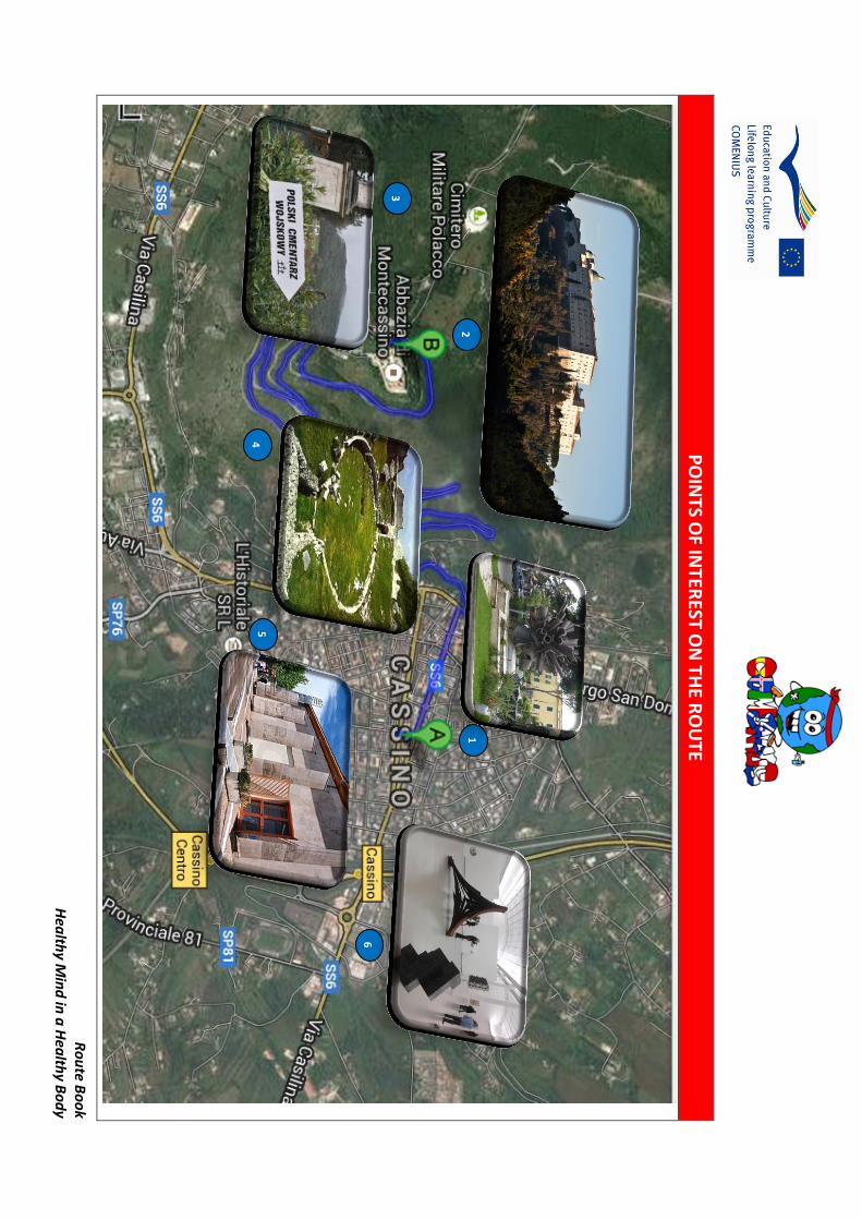
Ro
ute B
oo
k H
ealth
y Min
d in
a H
ealth
y Bo
dy
PO
INTS O
F INTER
EST ON
THE R
OU
TE
1
21
3
4
5
6

Route Book Healthy Mind in a Healthy Body
POINTS OF INTEREST
The Abbey of Montecassino The Polish War Cemitery
founded by Saint Benedict in 529, making it one of
Europe's oldest monasteries in the world. Destroyed during the WWII
Contains the graves of more than one thousad
Polish soldiers who died here in 1944 battle
Monumento della Pace The Ruins of the Colosseum
Monument for peace by Umberto Mastroianni
Just below the Montecassino remains of the past
Roman occupation of the town
The Historiale War Museum CAMUSAC Museum of Contemporary Art

THE NETHERLANDS Canisius RK Scholengemeenschap
Almelo/Tubbergen
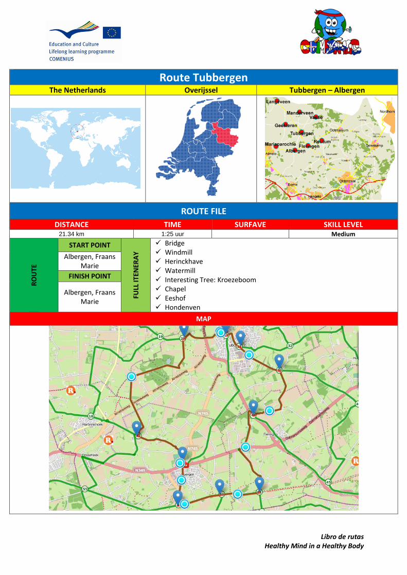
Libro de rutas Healthy Mind in a Healthy Body
Route Tubbergen
The Netherlands Overijssel Tubbergen – Albergen
ROUTE FILE
DISTANCE TIME SURFAVE SKILL LEVEL 21.34 km 1:25 uur Medium
RO
UTE
START POINT
FULL
ITEN
ERA
Y
Bridge Windmill Herinckhave Watermill Interesting Tree: Kroezeboom Chapel Eeshof Hondenven
Albergen, Fraans Marie
FINISH POINT
Albergen, Fraans Marie
MAP

Libro de rutas Healthy Mind in a Healthy Body
SUGGESTIONS AND OTHER INTERESTING DATA
Taking food or water may be advisable if there is no drinking water available on the way, taking a raincoat or some extra clothes might be necessary if the weather is usually changeable… etc.
CYCLE DESCRIPTION
Start at bicycle node number 57
You pass bicycle node number 58 Bike on the Zuid Kanaaldijk in an easterly direction After 75 m go straight on the cycle path After 35 m go straight ahead on the Rikkenspoelsweg After 460 m (bicycle node number 81 ) straight onto the cycle path After 670 m (bicycle node number 81 ), turn left at the Putmansweg Bike on the Putmansweg northern direction (bicycle node number 81 ) After 510 meters turn left at the Fleringerveldweg After 1 km turn right onto the cycle path After 220 meters turn left you leave the cycle path en uses the normal road After 1 km (bicycle node number 44 ), turn right at the Oldenzaalseweg Bike on the Oldenzaalseweg southwards After 20 meters turn left at the Lansinksweg After 880 meters turn left at the Wieschertsweg You pass bicycle node number 39 After 1 km turn left on the Reutummerweg Bike on the Reutummerweg westwards (bicycle node number 39 ) You pass bicycle node number 31 After 1 km turn right at the Weleveldstraat Bike on the Weleveldstraat westwards After 30 m (bicycle node number 31 ) bear right at the Reutummerweg After 100 m straight on to the Bruno van Ommen Street After 390 meters turn left at the Uelserweg You pass bicycle node number 21 After 190 m turn right at the Hardenbergerweg After 240 m turn right onto Eeshoflaan After 90 m it is a home zone After 5 m right down the path Bike on the trail northward After 290 m turn left at the home zone After 5 m straight on the Eeshoflaan After 90 m ahead on the Huyerenseweg Follow Huyerenseweg, after 1km left (bicycle node number 20 ) Bike on the Huyerenseweg westward After 55 meters turn left at the Veldweg After 960 m turn right into the path After 1 km turn left on the Hunzeweg After 850 m straight on the Weversweg After 390 m (bicycle node number 22 ) straight to the streets After 760 m turn right at the Hagweg
Libro de rutas Healthy Mind in a Healthy Body
Bike on the Hagweg eastwards After 640 m back on the Peggenweg After 660 m turn right on Mountain Road Cream After 30 meters turn left at the Kemnaweg After 650 m on the cycle path Follow the bike path after 5 m (bicycle node number 23) left After 55 m turn right at the Zenderseweg
After 40 meters turn left at the Hobergenstraat
After 170 m turn left onto Philip Street on Robben
After 95 m go straight to the Monastery Esweg
After 5 m left the bicycle path
After 75 m turn right into the street
Bike on the street southbound
After 100 m turn left onto the cycle path
After 75 m turn right at the Monastery Esweg
After 5 m on the Philip Street on Robben
After 95 m turn right at the Hobergenstraat
After 170 meters turn left at the Zenderseweg
After 660 m diagonally left the cycle path
You end up with bike node number 57

Libro
de ru
tas
Hea
lthy M
ind
in a
Hea
lthy B
od
y
PO
INTS O
F INTER
EST ON
THE R
OU
TE

Libro de rutas Healthy Mind in a Healthy Body
POI’s
Node 81: The Rikmansbrug at Fleringen is one of the four drawbridges over the canal opened in 1866 Almelo - Nordhorn, which now no longer
used for shipping is.
In 1822 an oil mill was built on the present site by the family von Bönninghausen (the former
inhabitants of the Havezathe Herinckhave), it is build because the castle often had insufficient
water. In 1844 it burned down. In the same place was in 1846 on an increase, due to windmills drag
of surrounding trees, the current round stone ground sailor. The farmers had to drive on one side up the hill and on the other side down. The mill is
furnished as corn and hulling mill and is also known under the names: Grobben Möl or Fleringermolen. The name comes from the
Grobben Möl Grubbe family, who were formerly residents of Herinckhave.
In 1916, the external assets of the Herinckhave were sold. The former tenant, T. H. Miller Frielink bought the mill. He has earned a living there until 1931. After his death, the mill was operated by his
brother, Bernard and son John. In 1936 the mill was decommissioned.
In 1937 the mill was owned by the wool manufacterer Ten Bos from Almelo, to save the
mill from demolition. The already ruined mill was restored shortly after purchase.
In 1955 he transorted the mill to Tubbergen. The mill then underwent immediate restoration; in
1975, again followed strong recovery.In september 2009 restoration; in 1975, again followed strong
recovery. In September 2009 began a new

Libro de rutas Healthy Mind in a Healthy Body
restoration this mill is now been able to grind again. In the 14th century Herinckhave mentioned for the first time as the Court Vlederinghe. From 1385 the estate came into the possession of the Grubbe family. It is then a fief of the bishop of
Utrecht. Friedrich Christian von Bönninghausen and
Johanna Maria Antonetta Grubbe builded a new house, the present Havezate. Herinckhave grew
into a large estate. It consisted of heathland, woods, more than six hundred thirty-five acres of
farmland and farmsteads. In 1959 the house was burned, and in 1970 the
house was restored by the Overijssel Castles Foundation. The private estate is now occupied by the former pediatrician Charles Bijleveld and Lady
Gisela von Bönninghausen.
POI’s
You will pass the Kroezeboom (right), which probably is between 400 to 500 years old. Kroezeboom means cross-tree, a tree that
indicates a boundary or junction. In the 16th century there was a chapel and during the
Reformation Eucharistic celebrations were held in secret. The present chapel dates from 1944.

Libro de rutas Healthy Mind in a Healthy Body
The Eeshof Tubbergen is a manor. The old manor was destroyed in 1582. The present house was built around 1719. It was also called Eschede. The building was formerly surrounded by a moat, as will be seen in part. The downstairs area is partly 18th century. In 1844 the Eeshof Mr. Herman Schaepman born, known priest and politician. There is a statue of him just outside Tubbergen Aat the Almeloseweg. The house is currently a nursing home. Behind the existing façade is a newly built complex that was completed in 1965.
Between Almelo and Tubbergen is situated the domain Schultenwolde and the Hondeven. The land is privately owned and is part of the heirs
Ledeboer. This domain consists of some oak-beech forest and moorland. Hondenven is a geological monument: it is a pingo-ruin. A pingo-ruin is a remnant from the ice age. In that period, there was located a groundwaterbel. By freezing, the
bubble expanded and formed a hill in the country: a pingo. As the climate became warmer, the ice hill thawed slowly and mud slid over the years to the edge. Eventually, a water-filled trough remained,
surrounded by a wall of sand higher.
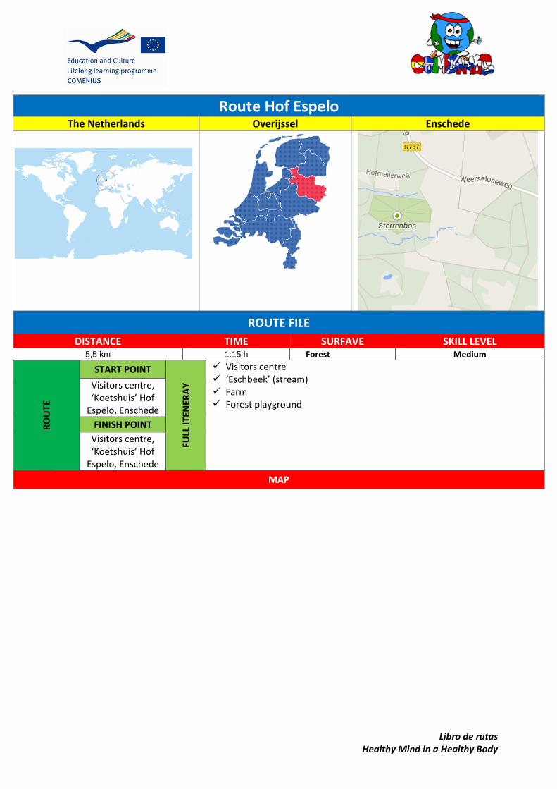
Libro de rutas Healthy Mind in a Healthy Body
Route Hof Espelo
The Netherlands Overijssel Enschede
ROUTE FILE
DISTANCE TIME SURFAVE SKILL LEVEL 5,5 km 1:15 h Forest Medium
RO
UTE
START POINT
FULL
ITEN
ERA
Y
Visitors centre ‘Eschbeek’ (stream) Farm Forest playground
Visitors centre, ‘Koetshuis’ Hof
Espelo, Enschede
FINISH POINT
Visitors centre, ‘Koetshuis’ Hof
Espelo, Enschede
MAP

Libro de rutas Healthy Mind in a Healthy Body
SUGGESTIONS AND OTHER INTERESTING DATA
Taking food or water may be advisable if there is no drinking water available on the way, taking a raincoat or some extra clothes might be necessary if the weather is usually changeable… etc.
CYCLE DESCRIPTION

Libro
de ru
tas
Hea
lthy M
ind
in a
Hea
lthy B
od
y
PO
INTS O
F INTER
EST ON
THE R
OU
TE
This ro
ute w
ill take you
thro
ugh
fields an
d p
astures, th
rou
gh fo
rest with
10
0 years o
ld trees an
d alo
ng th
e river the ‘Esch
beek’.
This ro
ute h
as old
a lot o
ld h
istory, o
ld farm
and
even so
me rem
ains fro
m W
orld
War ll.
So yo
u can
find
a lot o
f histo
ry and
cultu
re here.
There are also
a lot o
f activities thro
ugh
ou
t the year fo
r child
ren. O
r wo
rksho
ps an
d e
xcursio
ns w
ith frien
ds an
d fam
ily.

Libro de rutas Healthy Mind in a Healthy Body
POI’s
This visitor centre is the beginning from the route of Hof Espelo. Here you can find expositions of plant and animals. Here is also an organic shop with local products and you can drink here a cup of coffee.
Country house ‘Espelo’. Built in 1927 and is a monument.
‘Eschbeek’ stream

Libro de rutas Healthy Mind in a Healthy Body
Playground in forest ‘Klauterwoud’

Libro de rutas Healthy Mind in a Healthy Body

SCOTLAND Penicuik High School, Penicuik

Libro de rutas Healthy Mind in a Healthy Body
OLD RAILWAY
COUNTRY AREA LOCATION
ROUTE FILE
DISTANCE TIME SURFAVE SKILL LEVEL 9.5km 3h 50 Paved and gravel Medium
RO
UTE
START POINT
FULL
ITEN
ERA
Y Bridges, wildlife , river , viaducts and old railway platforms
Penicuik
FINISH POINT
Dalkeith
MAP
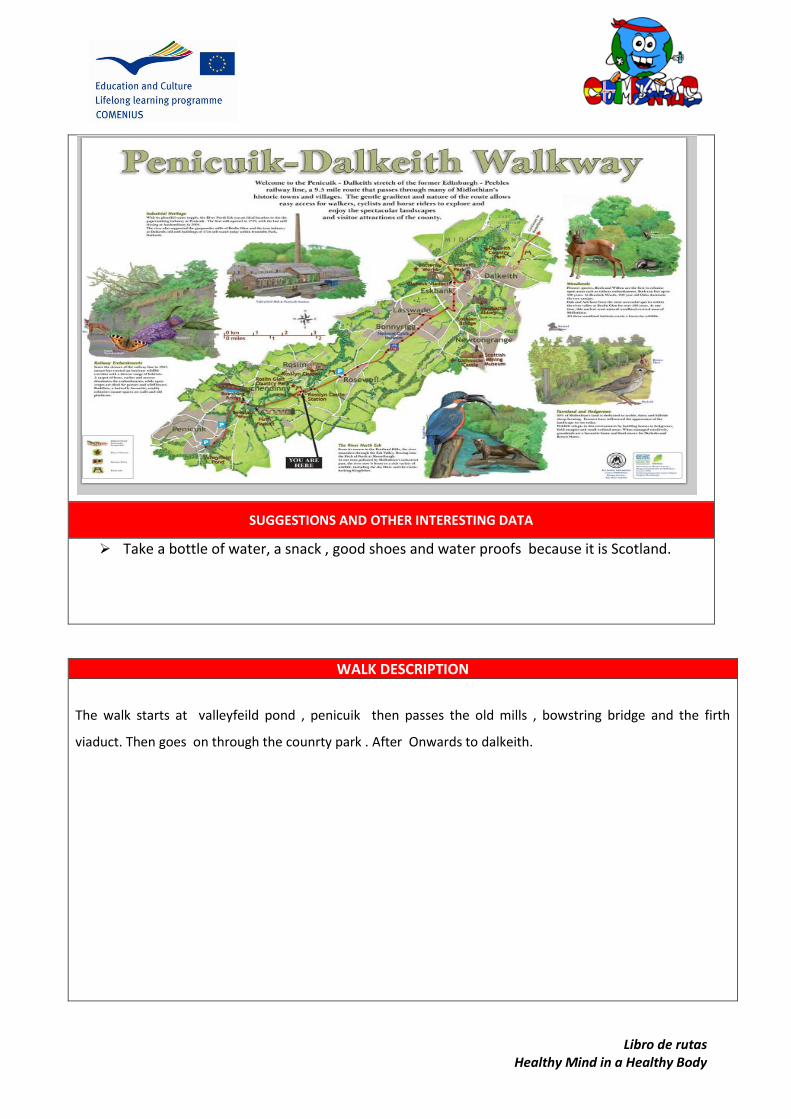
Libro de rutas Healthy Mind in a Healthy Body
SUGGESTIONS AND OTHER INTERESTING DATA
Take a bottle of water, a snack , good shoes and water proofs because it is Scotland.
WALK DESCRIPTION
The walk starts at valleyfeild pond , penicuik then passes the old mills , bowstring bridge and the firth
viaduct. Then goes on through the counrty park . After Onwards to dalkeith.
Arrow 1 Arrow 2

Libro de rutas Healthy Mind in a Healthy Body
1 penicuik valley feild
2 bowstring bridge
3 Firth viaduct
4 lea farm
5 rosewell
6 Dalkeith - butterfly world

Libro
de ru
tas
Hea
lthy M
ind
in a
Hea
lthy B
od
y
PO
INTS O
F INTER
EST ON
THE R
OU
TE
1
21
3
4
5
6
4
5
6
1
2
3

Libro de rutas Healthy Mind in a Healthy Body
Photos
Heading back tho penicuik passing the grassland
Near rosewell with tarmacked cycle paths
Just before the bridge heading over the
river esk
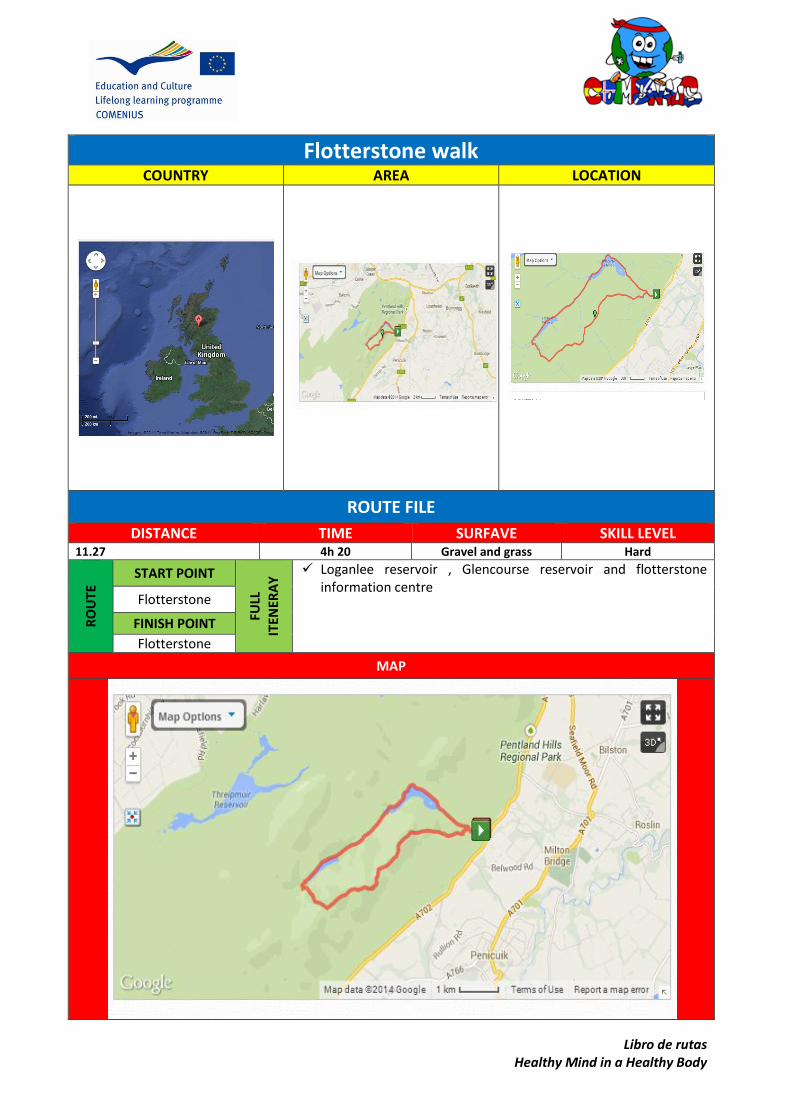
Libro de rutas Healthy Mind in a Healthy Body
Flotterstone walk COUNTRY AREA LOCATION
ROUTE FILE
DISTANCE TIME SURFAVE SKILL LEVEL 11.27 4h 20 Gravel and grass Hard
RO
UTE
START POINT
FULL
ITEN
ERA
Y Loganlee reservoir , Glencourse reservoir and flotterstone
information centre Flotterstone
FINISH POINT
Flotterstone
MAP

Libro de rutas Healthy Mind in a Healthy Body
SUGGESTIONS AND OTHER INTERESTING DATA
Take a bottle of water, a snack , good shoes and water proofs because it is Scotland.
WALK DESCRIPTION
This walk starts in Flotterstone near the pentlands at the flotterstone information centre . T he walk goes up the
hill past the Glencourse reservoir and back down the hill past the loganlee reservoir and then returnes to the
flotterstone information centre.
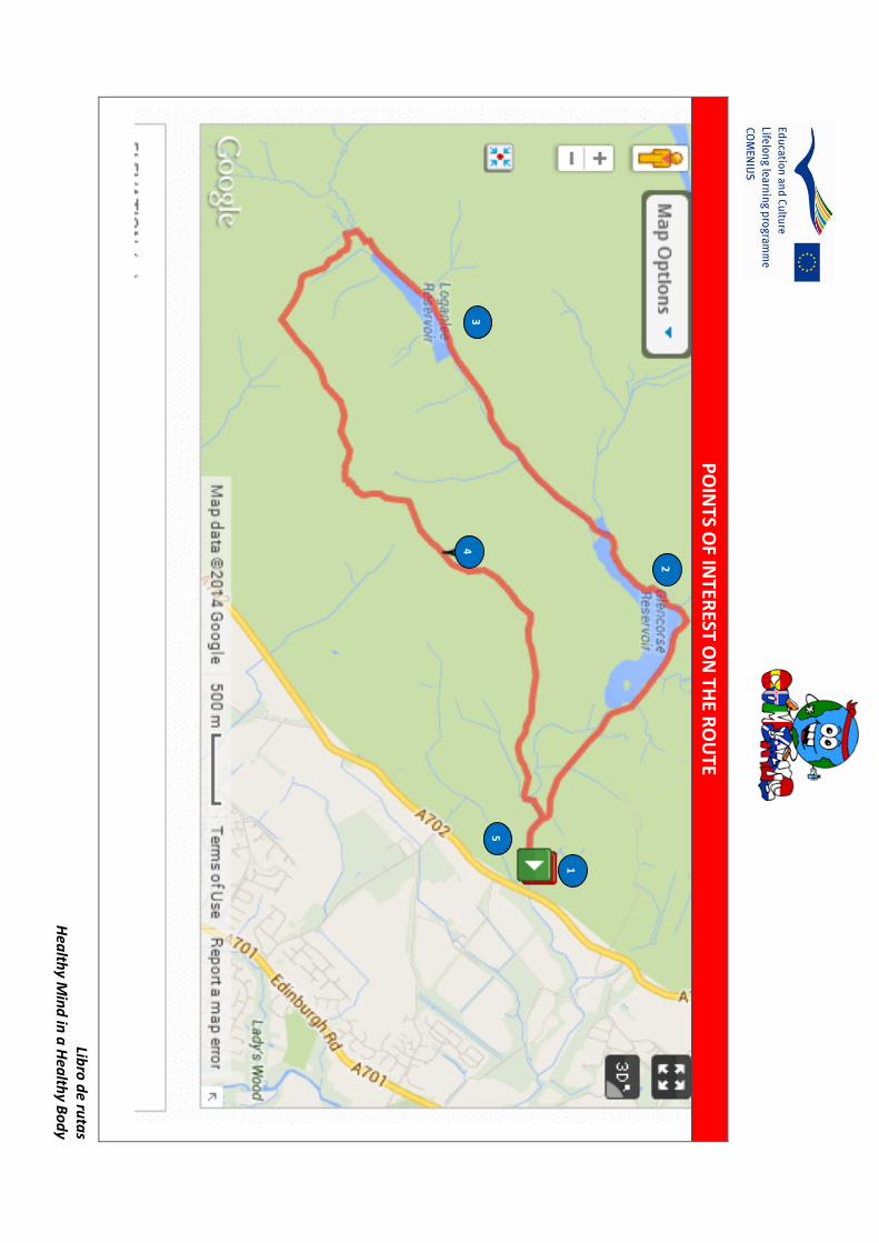
Libro
de ru
tas
Hea
lthy M
ind
in a
Hea
lthy B
od
y
PO
INTS O
F INTER
EST ON
THE R
OU
TE
1
21
3
4
5
4
5
6
1
2
3

Libro de rutas Healthy Mind in a Healthy Body
Photos
Glencourse reservoir
Flotterstone information centre
Loganlee reservoir

Libro de rutas Healthy Mind in a Healthy Body
JOHN CLARK ESTATE
COUNTRY AREA LOCATION
ROUTE FILE
DISTANCE TIME SURFAVE SKILL LEVEL 4.5 km 1h 30 Paved and gravel Medium
RO
UTE
START POINT
FULL
ITEN
ERA
Y Pond , bridge , Penicuik house, river and waterfall
Arrow 1
FINISH POINT
Arrow 2
MAP

Libro de rutas Healthy Mind in a Healthy Body
SUGGESTIONS AND OTHER INTERESTING DATA
Take a bottle of water, good shoes and waterproofs in case of big puddles or flooding along the river.
WALK DESCRIPTION
A quiet peaceful walk in close by woods beside the river esk.
Walk goes past quiet ponds with lots of wildlife and ruined house which is being re-built.
Lots of greenery with beautiful views .
Arrow 1 Arrow 2

Libro
de ru
tas
Hea
lthy M
ind
in a
Hea
lthy B
od
y
PO
INTS O
F INTER
EST ON
THE R
OU
TE
1
21
3
4
5
6
(On
a map
, locate
and
illustrate w
ith p
ictures th
e mo
st imp
ortan
t
land
marks an
d p
oin
ts of in
terests in th
e area)
4
5
6

Libro de rutas Healthy Mind in a Healthy Body
POI’s
Trees on side of hill
Penicuik house durning the summer
Road with trees on side leading to
penicuik house

SLOVENIA Osnovna šola Matije Valjavca
Preddvor, Gorenjska
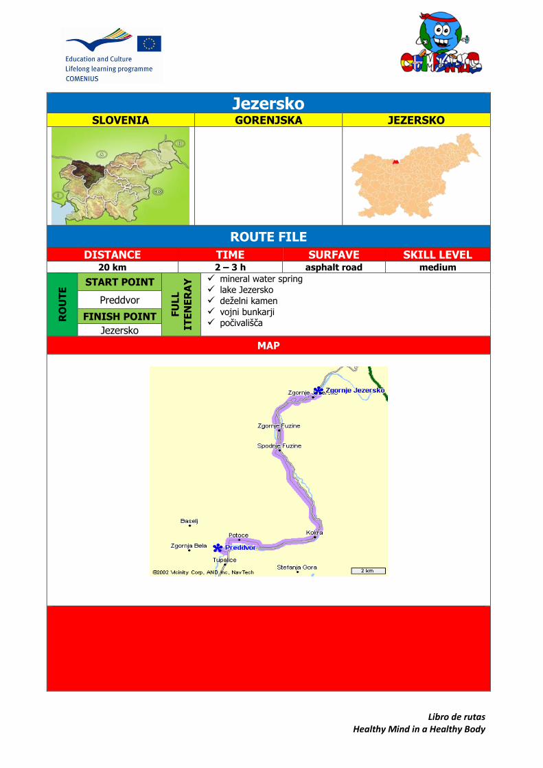
Libro de rutas Healthy Mind in a Healthy Body
Jezersko SLOVENIA GORENJSKA JEZERSKO
ROUTE FILE
DISTANCE TIME SURFAVE SKILL LEVEL 20 km 2 – 3 h asphalt road medium
RO
UT
E START POINT
FU
LL
IT
EN
ER
AY
mineral water spring lake Jezersko deželni kamen vojni bunkarji počivališča
Preddvor
FINISH POINT
Jezersko
MAP

Libro de rutas Healthy Mind in a Healthy Body
SUGGESTIONS AND OTHER INTERESTING DATA
Taking water may be advisable. Put on a helmet for your safety. Take some extra clothes.
WALK DESCRIPTION
Start your cycling tour in the centre of Preddvor, in front of TIC. If
you don't have your own bike you can hire it.
In front of TIC turn right and take the
main road. On the crossing after 800
metres turn left toward Jezersko and
cycle along the Kokra valley. After 1,5
km you can stop at Bee Museum Kokl
in Potoče. There you can see a beehouse and buy home honey
products.
Contiunue along the Kokra valley and admire its
beauty. Pass the village Kokra, the longest village in Slovenia. There is 17 km
from one point to the other. You can rest at a new rest-point, arranged for
cyclists .
At the end of the Kokra village there are two 1,5 m
high provincial stones on the left side of the road,
showing historical border between Carinthia and Carniola.
Follow the main road and after a few kilometres there is a guest house
"Kanonir" on the left side. If you are already tired you can have a rest
there because the road goes uphill even more. Cycle toward Zgornje
Jezersko and when you come to the village continue along the main
road.Turn right to the lake (Planšarsko jezero). Have a rest there and
enjoy a beautiful view to the nearest mountains.
The name of the area (Jezersko) derives from a glacial lake near the
settlement of Zgornje Jezersko that started to disappear after an

Libro de rutas Healthy Mind in a Healthy Body
earthquake in 1348. "Lake" means "jezero" in Slovene language.
Take the road on the left and after 750 m you will notice
Šenk's homestead. It is the oldest in the valley, regarding the
layout of the buildings. It was built after the big lake had
disappeared and the engraved year of 1517 above the
doorframe of the main building tells us of its age. Today there
is a tourist farm. For the horse lovers guided horseback riding
tours are available, as well as tour of 500 years old farm.
There are a campsite for individual and group camping and space for
picnics at the farm.
Continue to Jenko's barraks. This building was built in the 15th
century as a boarding house for merchants travelling to the north.
There you can decide whether to cycle up to the Seeberg Saddle
(Jezerski vrh), a high mountain pass connecting Jezersko with Bad
Eisenkappel in the Austrian state of Carinthia. It is at 1218 m altitude.
Otherwise turn left and take the main road. Take
the second exit on the right to Ank´s farm. You
can taste mineral water. You may continue on a
gravel road all the way to the farm. From there
follow the forest road, keep left at the crossroads
and continue for a few minutes. There are two
waterfalls, one after another dropping over the
rocks in the forest above Ank´s homestead. The waterfalls’ total height is
7 metres. They are located at the altitude of 1240 metres. Enjoy.

Libro
de ru
tas
Hea
lthy M
ind
in a
Hea
lthy B
od
y
PO
IN
TS
OF IN
TE
RE
ST
ON
TH
E R
OU
TE
1
21
3
4
5
6

Libro de rutas Healthy Mind in a Healthy Body
POI’s KOKRA VALLEY
The Kokra valley is one of the most picturesque alpine valleys. The road leads you through beautiful gorges and across many bridges. After heavy rain there are little watefalls all around.
PROVINCIAL STONES
LAKE PLANŠARSKO JEZERO
The little heart-shaped lake was created by local inhabitants in memory of a larger glacial lake that has now drained away. In summer, it allows boating and in winter skating as well as the chance to enjoy tasty local food all year round.
On the main road from Preddvor to Jezersko, stand two 1,5 metres high stones. These are provincial stones showing historical border between Carinthia and Carniola. Their position tells us that Jezersko was once part of Carinthia. Distances in kilometres to Kranj in Carniola and to Klagenfurt in Carinthia are engraved into the stones. Even though they do not represent borders anymore, the stones are still very important cultural monuments of Jezersko.

Libro de rutas Healthy Mind in a Healthy Body
ŠENK'S HOMESTEAD
Šenk’s homestead is considered the only homestead in the area where original buildings and architectural style have been preserved; typical rural settlement can be seen here.
JENK'S BARRACKS
This high and architecturally peculiar building was built in the 15th century as a boarding house for merchants travelling from Tržič to Eisenkappel and further on towards the river Drava when this was the easiest trespass to the north. It got its name later, maybe after Napoleon´s military stayed overnight in the barracks. Today the barracks is ethnographical museum exhibiting items and equipment that were used in everyday life on the farm.
MINERAL WATER SPRING
There is a mineral water spring above the Ankova farmhouse called "Jezerska slatina”. This water has the highest magnesium content of all mineral waters in Slovenia. Deep in a woods above the spring there are hidden waterfalls where you can leave the worries of everyday life far behind.
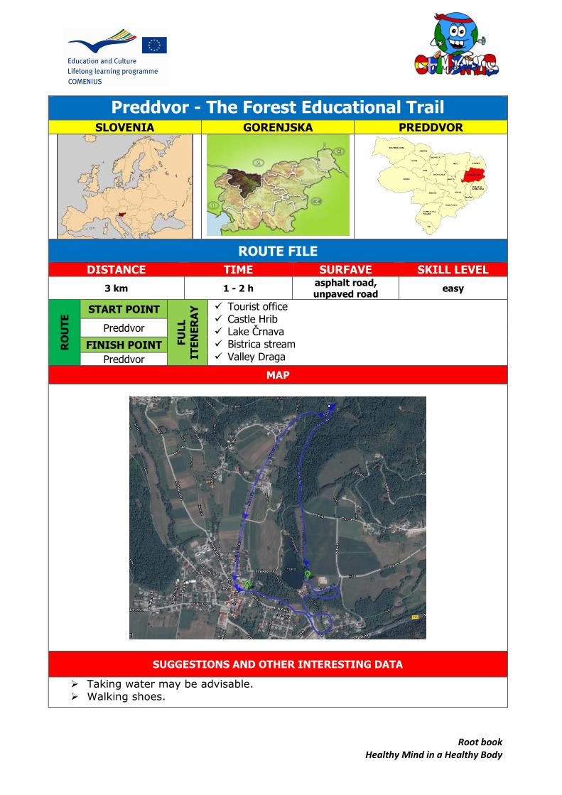
Root book Healthy Mind in a Healthy Body
Preddvor - The Forest Educational Trail
SLOVENIA GORENJSKA PREDDVOR
ROUTE FILE
DISTANCE TIME SURFAVE SKILL LEVEL
3 km 1 - 2 h asphalt road, unpaved road
easy
RO
UT
E START POINT
FU
LL
IT
EN
ER
AY
Tourist office Castle Hrib Lake Črnava Bistrica stream Valley Draga
Preddvor
FINISH POINT
Preddvor
MAP
SUGGESTIONS AND OTHER INTERESTING DATA
Taking water may be advisable. Walking shoes.

Root book Healthy Mind in a Healthy Body
WALK DESCRIPTION
In the forest educational trail in Preddvor there are trees which used to form the park
near the mansion Hrib.
The trail starts in front of the tourist office in the centre of Preddvor and goes past
Slančeva vila towards old stables, past castle Hrib, back to the hotel Bor, besides lake
Črnava, near Bistrica stream, towards valley Draga, where it finishes.
On the trail there are 28 different tree species marked with signs: Lawson's cypress,
hornbeam, beech, Canadian hemlock, Lebanon cedar, European larch, green pine,
American plane tree, cigar tree, Horse chestnut, avenue of American ash, giant sequoia,
White cedar, Scots pine, Black pine, Little-leaf Linden, poplar, common walnut, Oregon
pine, pedunculate oak, sycamore maple, black elder, black walnut, fir, Norway spruce,
common ash, hop hornbeam.
Most of the signed trees are foreign trees and were planted by former owners of the
manor. With these trees they formed a park. They wanted to have a collection of
unusual trees. Among them giant sequoias are the most interesting. They stand out
with their height and looks. Lawson's cypress and White cedar are related with giant
sequoia. The home of all three species is North America.
Lebanon cedar and American plane tree are very beautiful. Canadian hemlock is special.
These mentioned trees are between one hundred and a hundred and fifty years old.
On the trail we can recognize some of the tree species. We can compare white and
black hornbeam, spruce and fir, black and red pine. In the forest educational trail we
can gain a lot of knowledge. Not only about trees, but also about nature, that changes a
lot during seasons.
A Legend
There is a legend about the avenue of ash trees. Once upon a time there lived a
gardener in the Hrib Castle. He fell in a love with a young lady from the castle and she
loved him, too. They had secret meetings in the avenue. Only trees understood their
love. They covered them with their branches so nobody could see them. Finally, they
were allowed to get married. They lived happily for
fifty years, until the lady died. Even today it is
believed if the newly wedded walk through the
castle on their wedding day, they will have fifty
years of happiness and faithfulness.
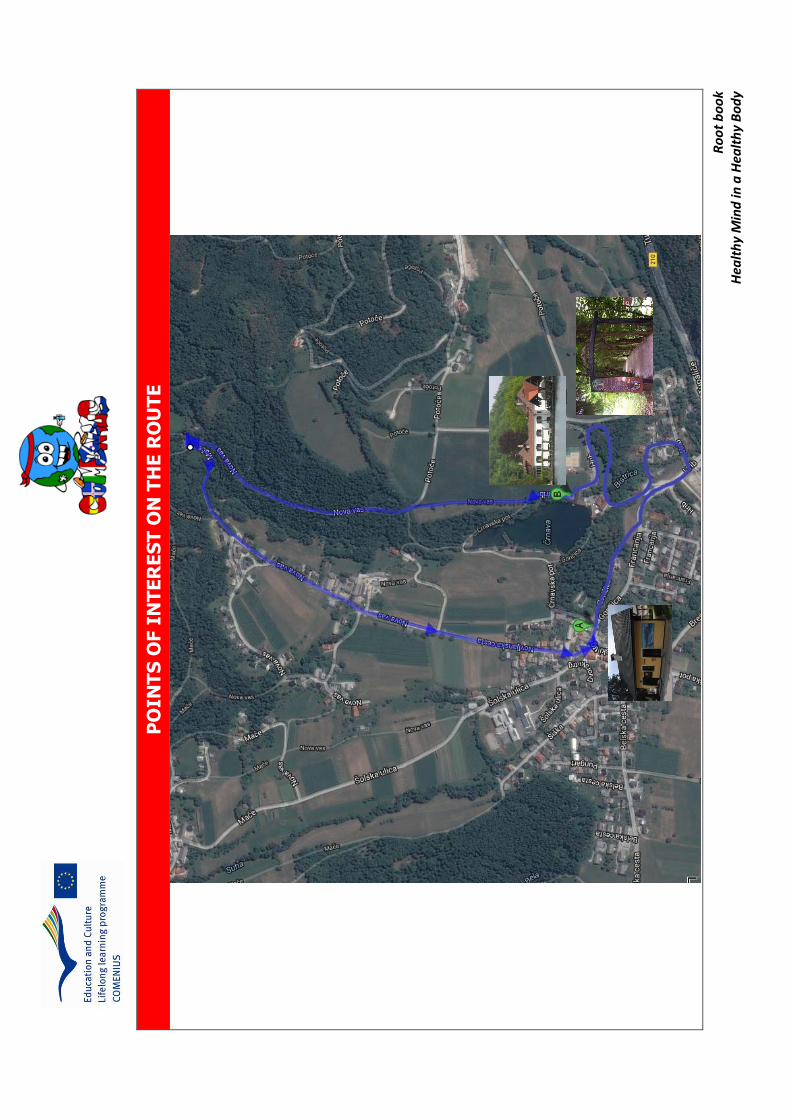
Ro
ot
bo
ok
Hea
lth
y M
ind
in a
Hea
lth
y B
od
y
PO
IN
TS
OF I
NT
ER
ES
T O
N T
HE
RO
UT
E
1
2 1
3
4
5

Root book Healthy Mind in a Healthy Body
POI’s
Lawson's cypress Beech (on the left)
Lawson's cypress (on the right)
Black walnut Sycamore maple

Root book Healthy Mind in a Healthy Body
Oregon pine Lebanon cedar
Bistrica stream Avenue of American ash

Route book Healthy Mind in a Healthy Body
Preddvor - SLOVENIA GORENJSKA PREDDVOR
ROUTE FILE
DISTANCE TIME SURFAVE SKILL LEVEL 1,8 km 30 - 60 min paved-gravel easy
RO
UTE
START POINT
FULL
ITEN
ERA
Y Church,
Dvor castle, Hrib castle, Turn castle Josipina Turnograjska shading
Preddvor
FINISH POINT
Potoče
MAP
SUGGESTIONS AND OTHER INTERESTING DATA
Walking shoes

Route book Healthy Mind in a Healthy Body
WALK DESCRIPTION
Start your tour in the centre of Preddvor, in front of the church of St Peter.
Behind the church there is an old Dvor castle.
Take the main road, pass TIC centre and then turn right. At the bottom of the slope turn left and
then walk through the forest to the Hrib castle. You can rest near the lake and admire nice view to
the nearest mountains. There is a legend of the devil’s forest on the mountain Zaplata.
A long time ago lived two farmers in a village at the foot of Zaplata
mountain. There was a forest, divided with a border, on their farms.
The farmers were always fighting whose the forest was. One day,
one of farmers had enough of quarrelling and said: “Let the devil take
it!” And at night the devil came, took the forest and carried it on his
back to Zaplata. When he was in the middle of the slope, the church
bell started to ring in the morning. The devil lost his power, dropped
the forest and ran away. The forest stayed in the middle of Zaplata
forever.
Then walk through the alley of ashes behind caste Hrib, turn left and go the next
castle – Turn castle. There you can visit the memorial room of Josipina Urbančič
Turnograjska, the first Slovenian female writer, poet and composer.
Continue your walk to the shading with eight limes planted in a circle above the
castle. Josipina Turnograjska liked to sit there and admire the nature.
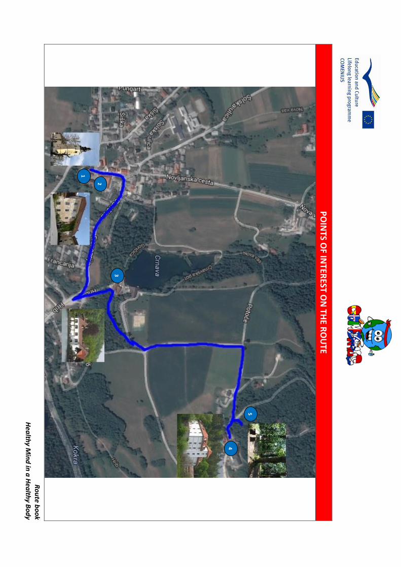
Ro
ute b
oo
k H
ealth
y Min
d in
a H
ealth
y Bo
dy
PO
INTS O
F INTER
EST ON
THE R
OU
TE
1
21
3
4
5

Route book Healthy Mind in a Healthy Body
POI’s CHURCH
DVOR CASTLE
The castle was first mentioned in the year
1147 when it was called Novi Dvor. The image
of the castle we see today dates from 17th
century. Monks turned the castle into
monastery where there was the first school in
the town. After the Second World War in 1945
children from Bosnia and Croatia who lost their
parents were placed at the castle. Later, there
was a Juvenile Centre for the primary school
children with behaviour and learning
problems. Now the castle is empty and it is
waiting for renovation.
HRIB CASTLE
Hrib castle was built in 16th century. It is located above the Kokra river, by the lake Črnava. Nowadays it doesn't look like the original, because many owners exchanged the castle and every one of them changed its look a little. In the year 1850 the castle was Fuschs manor. In the year 1924 the owner became Franc Dolenc, who reformed it into at tuberculosis hospital. But in the last few years it's mainly used for tourism. In the castle, there are also a marriage hall and a conference room.
The parish church of Saint Peter stands in the
centre of Preddvor, next to the Dvor Castle.
The first mention of a church was in year
1156, but it got today’s look in 1751. It was
reinforced during the Turkish invasions. The
belfry (1505) was preserved from this era as
well. The Church is baroquely decorated.
There are two paintings: the painting of Saint
Peter and Last Dinner from Janez Wolf (1825
– 1884). There is a shrine opposite the
church with frescoes from painter Leopold
Layer (1752 – 1828).
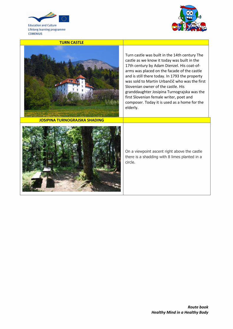
Route book Healthy Mind in a Healthy Body
TURN CASTLE
Turn castle was built in the 14th century The castle as we know it today was built in the 17th century by Adam Dienzel. His coat-of-arms was placed on the facade of the castle and is still there today. In 1793 the property was sold to Martin Urbančič who was the first Slovenian owner of the castle. His granddaughter Josipina Turnograjska was the first Slovenian female writer, poet and composer. Today it is used as a home for the elderly.
JOSIPINA TURNOGRAJSKA SHADING
On a viewpoint ascent right above the castle
there is a shadding with 8 limes planted in a
circle.
SPAIN Colegio San Ignacio, Oviedo

Libro de rutas Healthy Mind in a Healthy Body
Sendero Río Bordosa
COUNTRY AREA LOCATION
(DEPENDING ON THE SELECTED ITE
ROUTE FILE
DISTANCE TIME SKILL LEVEL 16 K.M 4 hours, 16 minutes Medium
RO
UTE
START POINT
FULL
ITEN
ERA
Y
Highlights: The wonderful river The weather of the autonomic comunity
How to get there: Drive on the A-319 between
Cazorla and El Tranco to the Torre del Vinagre´s
visitor centre (Centor de Visitantes Torre del
Vinagre), by the kilometre post 48. By this centre you find a narrow asphalt road
signposted to "Picifactoria" and
"Centor de Visitantes Río Borosa". Drive 1.5 km on
this road to the Río Borosa information
centre
FINISH POINT
You return to the start point
MAP
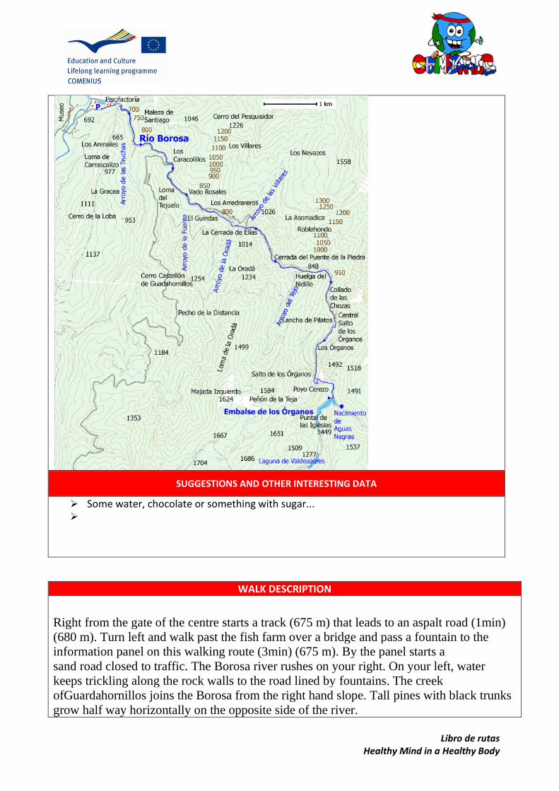
Libro de rutas Healthy Mind in a Healthy Body
SUGGESTIONS AND OTHER INTERESTING DATA
Some water, chocolate or something with sugar...
WALK DESCRIPTION
Right from the gate of the centre starts a track (675 m) that leads to an aspalt road (1min)
(680 m). Turn left and walk past the fish farm over a bridge and pass a fountain to the
information panel on this walking route (3min) (675 m). By the panel starts a
sand road closed to traffic. The Borosa river rushes on your right. On your left, water
keeps trickling along the rock walls to the road lined by fountains. The creek
ofGuardahornillos joins the Borosa from the right hand slope. Tall pines with black trunks
grow half way horizontally on the opposite side of the river.

Libro de rutas Healthy Mind in a Healthy Body
When this gently ascending road forks after crossing a bridge (23min) (725 m), go left
following the sign for "Laguna de Valdeazores". You cross another bridge (30min) (740
m) and encounter a wooden pole with a white arrow pointing right to a path (38min) (750
m). Follow this charming path that goes over threebridges before entering a narrow
passage (Cerrada de Elías) where the river brawls between sheer rock walls (52min) (775
m). Wooden railings protect you along this passage.
The path takes you to a track (58min) (785 m). Turn right. The track crosses a bridge and
continues uphill lined by magnificent rock walls towards the peaks of rising in front of
you. You pass a fountain and a number of brooks running down from the slopes.
The track ends after a bridge by a small group of buildings (1h35min) (915 m). On the
right hand side of the house you see a wooden pole waymarking a path. After crossing a
bridge (1h37min) (920 m) go straight ahead towards the cliffs with spraying water.
You ascend along the path between green mountainsides with old oaks passing
a waterfall to a tunnel (2h05min) (1220 m). A headlamp or a torch is helpful when you go
through this more than 100 meters long tunnel. A couple of minutes after the exit of this
tunnel, you meet another, much shorter tunnel (2h13min) (1220 m). Shortly after this one
you reach thereservoir with a bridge over the dam wall (2h20min) (1230 m). Return on the
same way back to the start point.

Lib
ro d
e ru
tas
Hea
lth
y M
ind
in a
Hea
lth
y B
od
y
PO
INTS
OF
INTE
RES
T O
N T
HE
RO
UTE
1
2 1
3
4
5
6
(On
a m
ap, l
oca
te a
nd
illu
stra
te w
ith
pic
ture
s th
e m
ost
imp
ort
ant
lan
dm
arks
an
d p
oin
ts o
f in
tere
sts
in t
he
area
)

Libro de rutas Healthy Mind in a Healthy Body
POI’s
SIMPLY THE SCENERY
The awesome river Bordosa

Libro de rutas Healthy Mind in a Healthy Body
“Ruta del Alba”
COUNTRY AREA LOCATION
ROUTE FILE
DISTANCE TIME SURFAVE SKILL LEVEL
7 km. 2 h. and 30 minutes
afoot Rocky soil, gravel
and land Easy
RO
UTE
START POINT
FULL
ITEN
ERA
Y Soto de Agues
El Retortiriu San Andrés Viewing point Fish Farm The washer
Soto de Agues
FINISH POINT
Cruz de los ríos
MAP
SUGGESTIONS AND OTHER INTERESTING DATA
Taking food or water may be advisable if there is no drinking water available on the way, taking a raincoat or some extra clothes might be necessary if the weather is usually changeable… etc.
It is advisable to do the route afoot.

Libro de rutas Healthy Mind in a Healthy Body
WALK DESCRIPTION
This one is, no doubt, one of the most important routes more known and visited of Asturias. We
begin our tour in “Soto de Agues”, that belongs to Sobrescobio's council.
We will come for the road AS-17 towards Tarna's port, up to Rioseco where we will take a detour
to the right that, without loss, will take us up to the wide parking that exists at the entry of "Soto de
Agues" and to the beginning of the route.
After going out of the villa we will find a peculiar
washer, with a good fountain, where we will be able
to fill our water bottle.
The track continues always parallel to the river
Alba. Passed a fish farm, we are gaining height softly
between meadows and woodland.
We continue walking, always for the cement
track, without the danger of taking a wrong
direction, just because the route is good specified.

Libro de rutas Healthy Mind in a Healthy Body
Then we arrive to Retorturiu's zone where there is a crossing. Here
we continue in our margin of the river but we leave the concrete.
Immediately we come to a great tightening of the valley, they are
the Foces del LLaimo. In this place the river forms continuous
waterfalls, whereas the way turns into path.
We have to cross, in our tour, two bridges of stone of half a point,
an authentic marvel of the popular architecture.
The path continues his ascension simultaneously while the
foces are closed on the river totally boxed in continuous jumps.
For this wide path carved in the rock, we will come to the
Cross of the Rivers, a beautiful place where the landscape is
opened suddenly, being able to enjoy the leafy surrounding
forests. Here also we will see the refuge of the Vega of the
LLaimo and in his surrounding areas an area with tables and
banks ... perfect to eat the bocata.
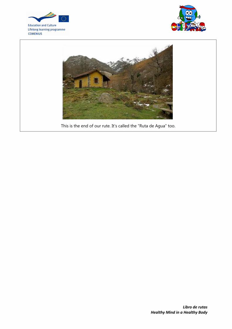
Libro de rutas Healthy Mind in a Healthy Body
This is the end of our rute. It’s called the “Ruta de Agua” too.

Lib
ro d
e ru
tas
Hea
lth
y M
ind
in a
Hea
lth
y B
od
y
PO
INTS
OF
INTE
RES
T O
N T
HE
RO
UTE
1 2 1
3
4
5
CA
ST
ILL
O
DE
VIL
LA
MO
R
EY
S
OT
O D
E
AG
UE
S
RÍO
DE
L
AL
BA
CR
UZ
DE
LO
S R
ÍOS

Libro de rutas Healthy Mind in a Healthy Body
IMPORTANT POINTS
THE CASTLE OF VILLAMOREY OR TOREXÓN HERMITAGES AND BRIDGES
THE NATURAL RESERVE OF REDES
The Nature reserve of "Redes", on the
other hand, is one of the spaces that
accumulates more figures of protection:
Nature reserve, Zones of Special Interest
for the Birds (ZEPA), Place of Community
Importance (LIC), Reservation of the
Biosphere for the UNESCO.
The Castle of Villamorey or Torrexón, in
ruins, but in an enclave so privileged that
wakes up the imagination of the onlooker
who ends for reconstructing the epoch, the
past life.
Bridges and hermitages of popular style,
both constructions in stone, raised
concerning the XVIIth and XVIIIth century
like San Roque's hermitage or that of the
Holy Angel in Oviñana.
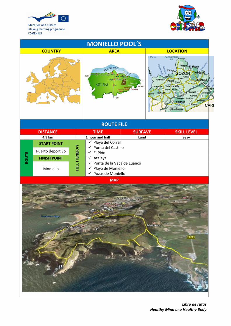
Libro de rutas Healthy Mind in a Healthy Body
MONIELLO POOL´S
COUNTRY AREA LOCATION
ROUTE FILE
DISTANCE TIME SURFAVE SKILL LEVEL 4,5 km 1 hour and half Land easy
RO
UTE
START POINT
FULL
ITEN
ERA
Y Playa del Corral
Punta del Castillo El Pión Atalaya Punta de la Vaca de Luanco Playa de Moniello Pozas de Moniello
Puerto deportivo
FINISH POINT
Moniello
MAP

Libro de rutas Healthy Mind in a Healthy Body
SUGGESTIONS AND OTHER INTERESTING DATA
Take food or water It is recommended to walk the route because there are stairs.
WALK DESCRIPTION
Starting at the stairs situated at the entrance to the marina, we started our walk in the direction of Mofosa
The first part is the most difficult as the route ascends up to the Peroño Mountain. Once you get to the highest point, the path enters into scrub; in the distance we can see Moniello, from this point we start to descend in the shadow of eucalyptus trees.
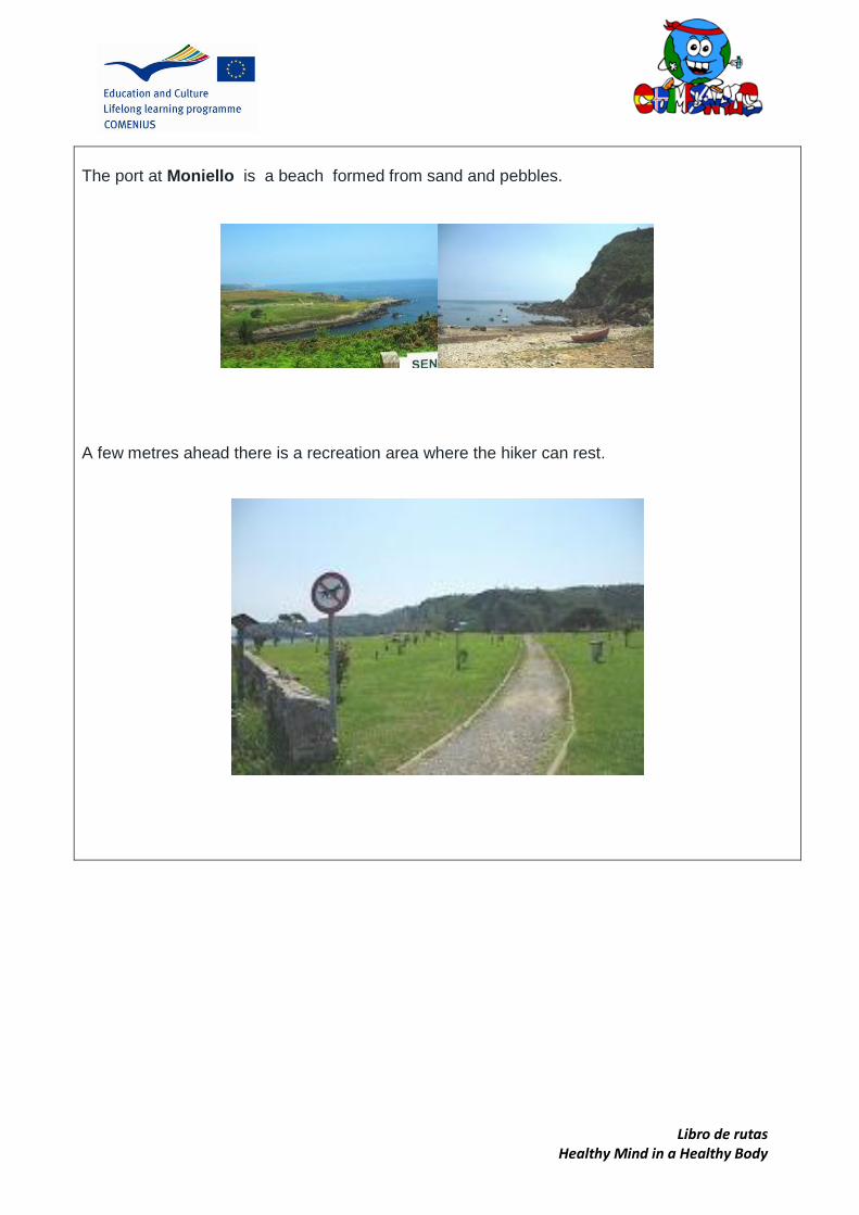
Libro de rutas Healthy Mind in a Healthy Body
The port at Moniello is a beach formed from sand and pebbles.
A few metres ahead there is a recreation area where the hiker can rest.
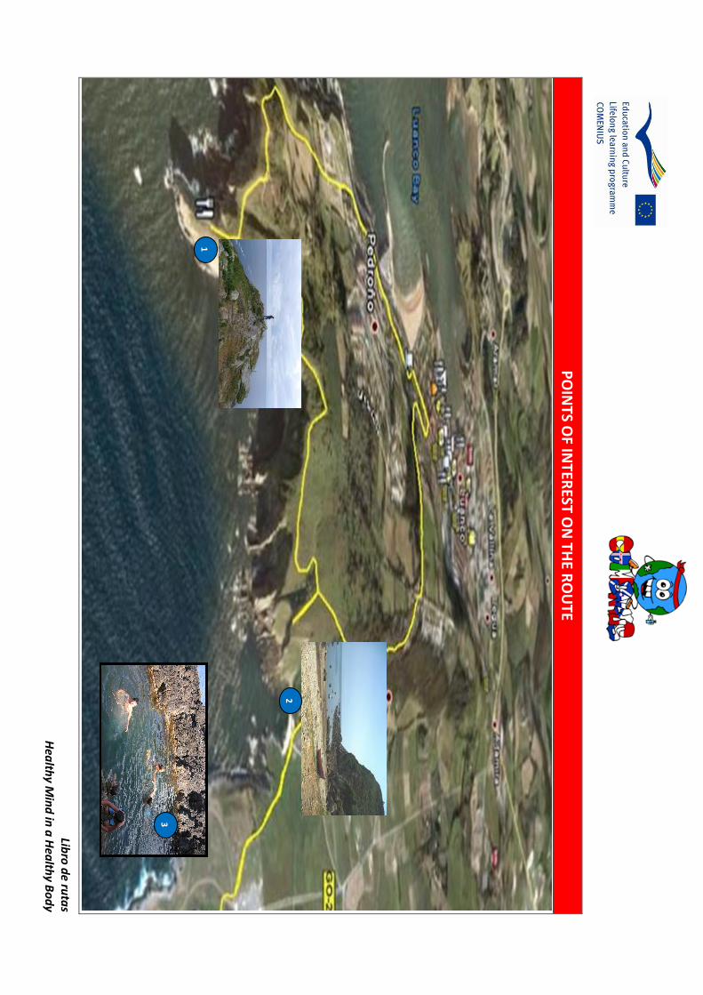
Libro
de ru
tas
Hea
lthy M
ind
in a
Hea
lthy B
od
y
PO
INTS O
F INTER
EST ON
THE R
OU
TE
1
21
3
Libro de rutas Healthy Mind in a Healthy Body
POI’s
Punta de la vaca de Luanco
It is a beautiful place in the path where we can watch the Moniello´s cove and Cabo Peñas´
environment.
Moniello´s beach
Is a beach formed from sand and pebbles. Some fishers use it for mooring their boats.
Moniello´s natural pools They are formed in the pebbles and the
people can swim in them.

Libro de rutas Healthy Mind in a Healthy Body
The Path of the bear COUNTRY AREA LOCATION
ROUTE FILE DISTANCE TIME SURFAVE SKILL LEVEL
21 km 5 hours by foot Concrete Easy
RO
UTE
START POINT
FULL
ITEN
ERA
Y
Entrago. Caranga de Abajo. Proaza. Cercado de los osos. Área Recreativa Buyera.
Entrago
FINISH POINT
Tuñón
MAP
Villanueva. Tuñón.

Libro de rutas Healthy Mind in a Healthy Body
SUGGESTIONS AND OTHER INTERESTING DATA
It is recomended to make by a foot or bicycle. There are a lot of points to rent bicycles. You can see bears close to the path
WALK DESCRIPTION
Our path start in Entrago. To go there you have to go to Teverga. Teverga is in the south of Asturias near to
Lena.
Once you are in teverga you have to go to for a road near the river Páramo.

Libro de rutas Healthy Mind in a Healthy Body
You have to go along this road and you arrive to “Las Vegas”.
Then you arrive to Avenida Prau Palacio and you have to go along untill the first exit to the left
Then there is a signal “Senda del Oso” (the name of the our path). You go along the street and you have to
turn on the right and you find the cross taht you an see in the picture.
Libro de rutas Healthy Mind in a Healthy Body
Finally you have to go along until you see the parking of “The Bear Path”
The path goes in an old minning train railway. And you can see two bears: Paca and Tola.

Libro
de ru
tas
Hea
lthy M
ind
in a
Hea
lthy B
od
y
PO
INTS O
F INTER
EST ON
THE R
OU
TE
1
21
3

Libro de rutas Healthy Mind in a Healthy Body
POI’s PROAZA PEÑAS JUNTAS
Proaza is a nice village and there is a hydraulic
power plant
There are two very big united stones. Between the
rocks there is a small way and it is a nice
landscape.
CERCADO DE LOS OSOS
It is the place where the bears: Paca y Tola live in.
It is like their house where they eats and sleep.
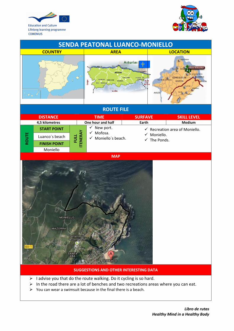
Libro de rutas Healthy Mind in a Healthy Body
SENDA PEATONAL LUANCO-MONIELLO
COUNTRY AREA LOCATION
ROUTE FILE
DISTANCE TIME SURFAVE SKILL LEVEL 4,5 kilometres One hour and half Earth Medium
RO
UTE
START POINT
FULL
ITEN
ERA
Y New port.
Mofosa. Moniello´s beach.
Luanco´s beach
FINISH POINT
Moniello
MAP
SUGGESTIONS AND OTHER INTERESTING DATA
I advise you that do the route walking. Do it cycling is so hard. In the road there are a lot of benches and two recreations areas where you can eat. You can wear a swimsuit because in the final there is a beach.
Recreation area of Moniello. Moniello. The Ponds.

Libro de rutas Healthy Mind in a Healthy Body
WALK DESCRIPTION
The route starts at Luanco´s beach. When you will arrive to the end of the beach, you could see the
new port. There, there are stairs. You go up stairs and start the road.
You will arrive to Mofosa. There, you will see a recreation area, where you can rest. And a park,
where the children could play. The landscape there is really lovely.
There is a hippic too. The people go there to see the horses races.

Libro de rutas Healthy Mind in a Healthy Body
At any time you will have a nice view of the sea. You will see the Cape of Peñas if weather is good
enough.
One of the stages of our walk is through a forest. There are many trees and enjoying the views and
the environment it will be a pleasure.
When you are finishing the route, there is a beach of rocks. The beach is so beautiful. You can see
swim there.
In front of the beach there is a restaurant where you could have a snack or enjoy a good meal.

Libro de rutas Healthy Mind in a Healthy Body
If you go upstairs, you will be at the recreation area of Moniello. It´s so big and there is a bar and a
park.
In the end of our walk, there are the famous Ponds of Moniello. The pools were made in the rocks
when the tide went up and carved them. It´s so funny swimming there!

Libro
de ru
tas
Hea
lthy M
ind
in a
Hea
lthy B
od
y
PO
INTS O
F INTER
EST ON
THE R
OU
TE
1
21
3
4
5

Libro de rutas Healthy Mind in a Healthy Body
POI’s LUANCO´S BEACH NEW PORT
Is the beach of Luanco. Before, the beach was very small but in 1995 brought artificial sand and now
it´s bigger.
HIPPIC MONIELLO´S BEACH
PONDS OF MONIELLO
The port of Luanco was renovated the
last year. Now, there are 190 boats
there.
This hippic was renovated this year.
Since 6 years that there aren´t
competitions in Luanco.
Really this is a cove because is very
small and it´s a natural port. There
isn´t many sand.
There are the pools make in the rocks
when the tide go up.