rocks are the subject of this geological tour.brovey.yolasite.com/resources/redrock_tour.pdf ·...
TRANSCRIPT

From Bob and Nancy’s Geotourism Site http://ozgeotours.110mb.com
Red Rock is a small coastal village on the mid north coast of NSW that boasts a spectacular and unusual headland. The village is surrounded by the Solitary Islands Marine Park and attracts people who enjoy outdoor activities. The village acquired its name from the distinctive red rocks which comprise the prominent headland. These rocks are the subject of this geological tour.
The rocks that make up the headland at Red Rock are named the Redbank River beds. They comprise fine grained sedimentary rocks that were deposited in the ocean below wave and most current activity. Deposition possibly took place near an underwater volcanic vent. We will see evidence for this in the tour.
The Redbank River beds are very strongly deformed. They are folded and faulted and have been forced into very contorted shapes (resembling strings of packaged minced meat).
These rocks are an enigma to geologists. They occur only at Red Rock. We do not know if they are older, or younger than the rocks that outcrop elsewhere in the Coffs Harbour district. Their age may range from Silurian to Carboniferous, spanning an interval from about 420 million years to 350 million year old.
Some geologists have concluded that the unique rock types and deformation features of the Redbank River beds at Red Rock are so different from other nearby rocks in the Coffs Harbour district, that they must have been deposited and deformed elsewhere prior to emplacement in their current location. One possible explanation for this is that the Red Rock headland is a huge block of rock which was broken from its original site of deposition and deformation, and dropped into deeper water where it was engulfed by younger sediment. Another possibility is that these rocks may represent a small preserved portion of the older rocks which must occur below the surrounding rocks in the district.
This self-guided tour commences at the southern end of the headland and travels to its northern end before continuing at the eastern end of the creek and travelling westward. This is generally quite an easy walk which may take several hours to complete. To see most outcrops it is best undertaken at low tide. Be careful at the base and top of cliffs or steep slopes on the headland, and beware of incoming waves near the shoreline. Sturdy shoes are recommended.

Page 2
From Bob and Nancy’s Geotourism Site http://ozgeotours.110mb.com
Map 1. Aerial photograph of the Red Rock headland area, showing tour stops.

Page 3
From Bob and Nancy’s Geotourism Site http://ozgeotours.110mb.com
PERIOD YEARS AGO LIFE FORMS ORIGINATING GEOLOGICAL EVENTS
QUATERNARY 0
2,000,000
Human Beings
Changes in sea level result in formation of elevated rock platforms and extensive wind blown sand dunes. Calcification of sand and gravel in the intertidal zone to form beachrock.
TERTIARY
65,000,000
Grazing and carnivorous mammals No rocks preserved from this period in local area
CRETACEOUS
145,000,000
Last dinosaurs First flowering plants No rocks preserved from this period in local area
JURASSIC
200,000,000
First birds No rocks preserved from this period in local area
TRIASSIC
251,000,000
First dinosaurs and mammals No rocks preserved from this period in local area
PERMIAN
299,000,000
Mammal-like reptiles, last Trilobites No rocks preserved from this period in local area
CARBONIFEROUS
359,000,000
First reptiles; fern forests Major period of folding and faulting.
DEVONIAN
416,000,000
First amphibians and insects
SILURIAN
443,000,000
Vascular land plants Deep water marine conditions well away from a shoreline into which fine clay and silica were deposited with minor sand.
ORDOVICIAN
488,000,000
First corals, fish with vertebrae
CAMBRIAN
542,000,000
Shellfish, Trilobites
PRECAMBRIAN 700,000,000
1,500,000,000 3,500,000,000 4,500,000,000
Algae Complex cells Primitive cells Formation of the Earth
Stop 1. Folded sedimentary rocks, fault planes, microveins.
Caution should be observed at this site. Beware of incoming waves and do not approach the base of the cliff if other people are active about the top of the cliff on the headland. Also be aware that the rocks can be very slippery when wet.
The rocks present here are typical of those found across most of the headland. All of the rocks are sedimentary, having formed as fine grained sand, silt and clay deposited into very deep oceanic waters. The finely preserved, very continuous, ribbon-like layering in these rocks tells us that they were deposited in very still water, with no wave or current action to disturb the slowly settling sediment. The most common rocks here are cherts, very hard, fine grained rocks composed of microscopic silica grains (quartz is another form of silica). Sediment similar to this, known as ooze, is depositing at present in the deepest parts of our oceans from slowly settling siliceous skeletal remains.
Small amounts of iron oxide impart a red colour to the cherts, the resulting rock being termed jasper. The abundance of jasper on the headland has given rise to the name of the locality: Red Rock. You may also note local accumulations of brown iron oxide on the rocks. This has formed from the chemical weathering of pyrite (iron sulphide), a mineral which has probably formed from mineral-rich fluids given off by volcanic activity beneath the sea floor. Areas showing a coating of dark black, glossy mineral occur locally, the black mineral composed of manganese oxide, another mineral resulting from seafloor volcanic activity. This cliff displays some significant features for appreciating
Page 4
From Bob and Nancy’s Geotourism Site http://ozgeotours.110mb.com
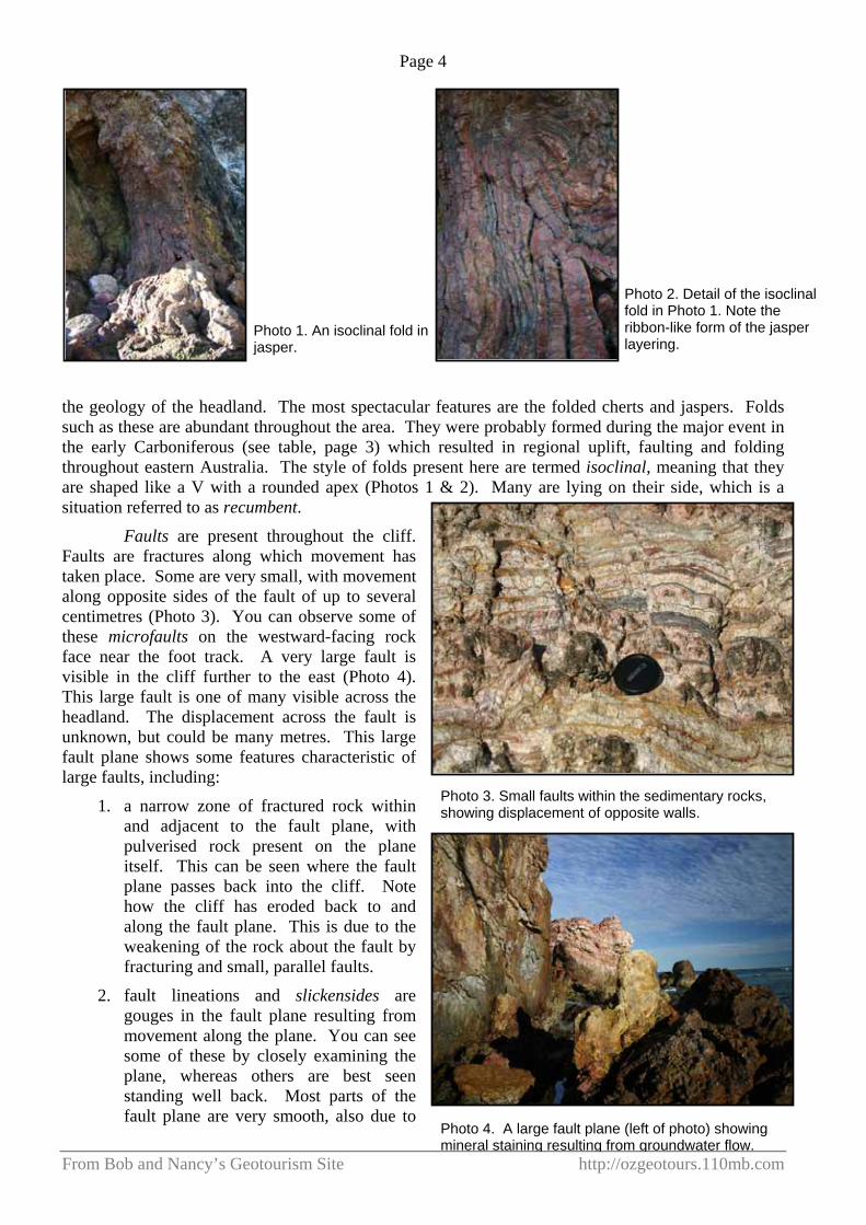
the geology of the headland. The most spectacular features are the folded cherts and jaspers. Folds such as these are abundant throughout the area. They were probably formed during the major event in the early Carboniferous (see table, page 3) which resulted in regional uplift, faulting and folding throughout eastern Australia. The style of folds present here are termed isoclinal, meaning that they are shaped like a V with a rounded apex (Photos 1 & 2). Many are lying on their side, which is a situation referred to as recumbent.
Faults are present throughout the cliff. Faults are fractures along which movement has taken place. Some are very small, with movement along opposite sides of the fault of up to several centimetres (Photo 3). You can observe some of these microfaults on the westward-facing rock face near the foot track. A very large fault is visible in the cliff further to the east (Photo 4). This large fault is one of many visible across the headland. The displacement across the fault is unknown, but could be many metres. This large fault plane shows some features characteristic of large faults, including:
1. a narrow zone of fractured rock within and adjacent to the fault plane, with pulverised rock present on the plane itself. This can be seen where the fault plane passes back into the cliff. Note how the cliff has eroded back to and along the fault plane. This is due to the weakening of the rock about the fault by fracturing and small, parallel faults.
2. fault lineations and slickensides are gouges in the fault plane resulting from movement along the plane. You can see some of these by closely examining the plane, whereas others are best seen standing well back. Most parts of the fault plane are very smooth, also due to
Photo 1. An isoclinal fold in jasper.
Photo 2. Detail of the isoclinal fold in Photo 1. Note the ribbon-like form of the jasper layering.
Photo 3. Small faults within the sedimentary rocks, showing displacement of opposite walls.
Photo 4. A large fault plane (left of photo) showing mineral staining resulting from groundwater flow.

Page 5
From Bob and Nancy’s Geotourism Site http://ozgeotours.110mb.com
movement and grinding of the rocks along the structure.
3. mineral precipitation has taken place on the fault plane as a result of groundwater movement along the fracture. Faults and fractures are a major means of groundwater movement within the crust, and are responsible for many springs. Groundwater carries dissolved minerals, some of which precipitate out into the rocks adjacent to the water conduit. You will notice this phenomenon on the large fault plane, with large areas of brown iron oxides coating the fault plane.
Areas adjacent to faults commonly contain mineral veins, such as quartz or calcite (calcium carbonate). The veins were emplaced as a result of the increased fracturing in the rocks near the fault, and due to opening up of the fractures by lateral movement of the rocks on opposite sides of the fault. The open fractures become low pressure sites into which groundwater and other fluids move, commonly carrying dissolved silica (quartz) and other minerals, including gold (where it is present as minute amounts in the nearby rocks). Over time these precipitate out, filling the cracks and forming veins. Some spectacular, very fine networks of veins occur through the rocks of the headland (Photo 5). Some of these take on a three dimensional, raised appearance due to differential erosion, the process whereby soft rocks are eroded faster than harder rocks.
To travel to Stop 2, take the track up the headland to the crest and walk to the southeastern end of the headland. Maintain a safe distance from the cliff line!
Stop 2. Coastal landforms and processes.
Many significant coastal landforms are visible from this vantage point. One obvious feature is the stack immediately to the south of the headland. A stack is a small, vertical, chimney-like rocky exposure formed by erosion of the cliff line about and behind the stack. The stack may be a harder, more erosion-resistant rock type, or an area of tough rocks surrounded by relatively softer rocks, or areas of faulting or fracturing.
The coastal view to the south shows a number of significant features. The crescent beach, which is such a typical vista on our coastline, derives its shape from the scouring effects of circulating currents driven by a primary, northerly-flowing current. The extent and shape of each crescent beach is ultimately determined by the presence of rocky headlands which interrupt the path and continuity of the currents. We can also observe the common beach-forming features, including the shoreline, high foredune, and coastal plain and wetlands further west. The shoreline is one of the most dynamic sedimentary environments, with a combination of wave, current and wind forces constantly shaping, eroding and depositing. The interaction of these forces results in well sorted sand or gravel, in which each component occupies a small size range due to the
Photo 5. A network of thin quartz veins in chert.
Photo 6. A stack, or raised, isolated rock has been eroded away from the headland. Note the recumbent fold in the west face of the stack.

Page 6
From Bob and Nancy’s Geotourism Site http://ozgeotours.110mb.com
winnowing and sorting action of the water and wind. Hence we generally have clean, mud and gravel-free sand on our beaches. Many beaches also host accumulations of heavy mineral beach sands (of which most commercial-scale deposits have been mined) which are accumulations of fine magnetite, ilmenite and zircon which have been sorted into rich layers by wave motion along the beach.
The large dunes and ranks of smaller dunes further inland are in some cases remnants of lower sea levels associated with global cooling events which occurred over the past 700,000 years. As the shoreline retreated seaward, large expanses of sandy seafloor were exposed. This was subjected to wind erosion which moved the sand inland as multitudes of shifting dunes. Those dunes were to some degree stabilised by vegetation in recent millennia. The large foredune reflects modern sea levels, with sand from the present shoreline blowing onto the foredune, where some is trapped and stabilised by vegetation.
As we see at Red Rock, the northern side of the headland is also a creek entrance. This is a common coastline relationship, resulting from the sheltering effect of the headland from the north-flowing currents. In the absence of the headland the currents would otherwise transport sand into the mouth of the watercourse, blocking and diverting it. Also note how the next crescent beach to the north commences to the west of the headland. This is a consistent phenomenon, probably related to a combination of scouring current eddies on the northern flank of the headland, and to erosion and transport of sand by the watercourse.
Stop 3. Recumbent folds, major fault, differential erosion.
This site is located near the major erosion inlet into the headland, with a good view of the small stack to the west. Be very careful near the vertical inlet as a fall here would be fatal!
The western wall of the stack displays some excellent examples of recumbent isoclinal folds (Photo 8). These resulted from strong compression within the crust which was not equal in all directions, allowing the compressed, contorted rocks to collapse in one direction. The wall shows repeated recumbent folds with well formed V shapes.
Photo 7. The beach south of Red Rock. Note the large foredune.
Photo 8. Recumbent isoclinal folds on the stack wall.
Photo 9. Large fault plane showing vertical striations indicating direction of movement.

Page 7
From Bob and Nancy’s Geotourism Site http://ozgeotours.110mb.com
Photo 10. View eastward into the inlet, showing a recumbent isoclinal fold, and the fault plane at bottom of photo.
The inlet is an example of differential erosion along a fault plane and its associated crushed and fractured rocks. The fault plane is visible on the western wall of the inlet (Photo 9). Note the very smooth, planar shape of the plane, the vertical lines on the plane and the mineral coating. The vertical lines demonstrate the major direction of motion of the fault, which in this case is vertical. It would be expected that a fault of this size would have produced significant displacement of the rocks on opposite sides. Thinly layered cherts on the opposite wall of the inlet display a number of folds, but are dominated by a single recumbent isoclinal fold (Photo 10).
Stop 4 can be accessed by walking northwards and travelling along the foot track until it reaches the edge of the headland. Be careful in this area as the rocks are slippery when wet, and large waves may wash high onto the rocks.
Stop 4. Folded cherts, microvein networks.
This section of the headland shows a large expanse of the rocks free of soil or sand cover. Features of note here include the thin, ribbon-like layering of the cherts, and the locally abundant isoclinal folds. There is also another example of a quartz vein network.
Stop 5. Mass flow sandstone.
After following the track onto the beach, walk along the sand to the east until the first rocky outcrops are encountered in the sand. This may not be easily examined at high tide.
These very interesting rocks include grey sandstone with thin interlayers of red mudstone. These rocks contrast markedly with those which form the headland. They possibly represent a change in depositional conditions at the time, with deposition of oozes being temporarily overwhelmed by an influx of coarser grained sediment from the land. As you will see at Stops 7 and 8, the style of sedimentation in this area continues to be quite different to that on the headland.
The outcrops here include grey sandstone which shows only limited amounts of layering (Photo 11). The layering only occurs locally, and in places passes into sandstone which is devoid of layering (known as massive sandstone). Small amounts of thin, red mudstone occur within parts of the sandstone. The mudstone layers show very irregular, wispy, branching forms (Photo 12). These features suggest that whilst the siliceous oozes were forming on the deep ocean floor, sandy sediment and mud was also depositing closer to land in shallower water. As still happens in our modern oceans, coarser material sporadically detaches from its depositional site, in many cases due to earth tremors, and slides along the sea floor into deeper water. This can occur over distances of many kilometres. Material that is moved in this way is known as a mass flow. During the period of transport, some or all of the original sedimentary features may be lost as the sand and mud become intermixed and homogenised. Features indicative of this can be seen in these outcrops, with layering showing
Photo11. A remnant of layered sandstone passing outward into massive sandstone which has been disrupted during mass flow.

Page 8
From Bob and Nancy’s Geotourism Site http://ozgeotours.110mb.com
irregular, discontinuous form passing into areas of sandstone which are devoid of layering. Instability and movement within the original interlayered sand and mud has disrupted the thin muddy beds, squeezing the mud into the sand, creating the textures we see in this outcrop. Some degree of liquefaction of the sand and mud would have taken place, with the sea water trapped in the sediment moving about during the period of transport and playing a major part in the disruption of the once well layered sand and mud.
Examine the outcrops here and you will find many features indicative of mass flow. Discontinuous layers of different coloured sandstone can be found further from the shoreline (Photo 13), and thin, disrupted muddy layers are abundant throughout the massive sandstone. Note the margins of the pale yellow sandstone layer shown in Photo 13. The lobes and finger-like protrusions suggest that the two different coloured sands were very fluid, with some degree of injection into one another. Also note that the darker sand is mottled with patches and wisps of paler sandstone, suggesting some intermixing of the two sand types. Several small faults are also visible in this outcrop.
Stop 6 is reached by walking across the stony section of the beach to the large red boulders against the headland. This may not be easily reached at high tide.
Stop 6. Jasper, manganese oxide, efflorescence.
This prominent, red outcrop comprises ribbon layered jasper with abundant black surface coatings of glossy manganese oxide. The manganese mineral here may be pyrolusite, psilomelane, or a mixture of both. Manganese oxides such as these commonly occur with jasper and can locally form masses up to several metres thick and up to hundreds of metres long. Large volumes of manganese oxide can be mined, the material being used for a variety of purposes including dry cell battery terminals and manganese.
Many of the cracks in the rock show a pale mineral encrustation. This is known as an efflorescence, a combination of low solubility salts formed from the weathering and chemical decomposition of metalliferous sulphide minerals in the rock. As well as being associated with manganese oxide minerals, some jaspers are associated with minute to large amounts of iron, zinc and/or copper-bearing sulphides. These have formed from local sea floor volcanic activity. In many parts of New South Wales and the world these minerals, in
Photo 12. Thin, disrupted red mudstone layers within massive grey sandstone.
Photo 13. Pale sandstone bed showing margins indicative of injection into the surrounding sandstone. Also note the small-scale faults.
Photo 14. Red jasper showing prominent coatings of black manganese oxide.
Page 9
From Bob and Nancy’s Geotourism Site http://ozgeotours.110mb.com
close association with jasper and basalt, have been mined. Generally, however, the sulphide minerals are in very low concentrations, their presence usually only being noted by the iron oxide and mineral efflorescence on adjacent rock surfaces.
To proceed to Stop 7, return along the beach past Stop 5. Walk to the long bar of red rock which extends into the creek before the prominent outcrop near the access ramp is reached (see Map 1). This may not be accessible at high tide.
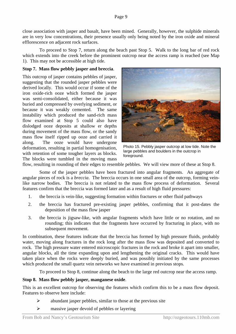
Stop 7. Mass flow pebbly jasper and breccia.
This outcrop of jasper contains pebbles of jasper, suggesting that the rounded jasper pebbles were derived locally. This would occur if some of the iron oxide-rich ooze which formed the jasper was semi-consolidated, either because it was buried and compressed by overlying sediment, or because it was weakly cemented. The same instability which produced the sand-rich mass flow examined at Stop 5 could also have dislodged ooze deposits at shallow er depths during movement of the mass flow, or the sandy mass flow itself ripped up ooze and carried it along. The ooze would have undergone deformation, resulting in partial homogenisation, with retention of some tougher layers as blocks. The blocks were tumbled in the moving mass flow, resulting in rounding of their edges to resemble pebbles. We will view more of these at Stop 8.
Some of the jasper pebbles have been fractured into angular fragments. An aggregate of angular pieces of rock is a breccia. The breccia occurs in one small area of the outcrop, forming vein-like narrow bodies. The breccia is not related to the mass flow process of deformation. Several features confirm that the breccia was formed later and as a result of high fluid pressures:
1. the breccia is vein-like, suggesting formation within fractures or other fluid pathways
2. the breccia has fractured pre-existing jasper pebbles, confirming that it post-dates the deposition of the mass flow jasper
3. the breccia is jigsaw-like, with angular fragments which have little or no rotation, and no rounding; this indicates that the fragments have occurred by fracturing in place, with no subsequent movement.
In combination, these features indicate that the breccia has formed by high pressure fluids, probably water, moving along fractures in the rock long after the mass flow was deposited and converted to rock. The high pressure water entered microscopic fractures in the rock and broke it apart into smaller, angular blocks, all the time expanding upon and lengthening the original cracks. This would have taken place when the rocks were deeply buried, and was possibly initiated by the same processes which produced the small quartz vein networks we have examined in previous stops.
To proceed to Stop 8, continue along the beach to the large red outcrop near the access ramp.
Stop 8. Mass flow pebbly jasper, manganese oxide.
This is an excellent outcrop for observing the features which confirm this to be a mass flow deposit. Features to observe here include:
abundant jasper pebbles, similar to those at the previous site
massive jasper devoid of pebbles or layering
Photo 15. Pebbly jasper outcrop at low tide. Note the large pebbles and boulders in the outcrop in foreground.

Page 10
From Bob and Nancy’s Geotourism Site http://ozgeotours.110mb.com
gradations between the massive and pebbly forms
manganese oxide coatings
Most of the outcrop is made up of pebbles and small boulders of jasper (Photo 16). The pebbles have undergone a small amount of rounding, with many showing some degree of angularity.
The pebbles are surrounded and supported by massive red jasper. This is to be expected if the original, partially solidified ooze was disrupted and fragmented during mass flow transport, then dumped on the sea floor with no sorting of large from fine fragments.
A large block of massive jasper occurs towards the centre of the outcrop (Photo 17). This may be a very large boulder of massive jasper, or an area of totally homogenised jasper, in which the pebbles formed in the early stages of mass flow were destroyed subsequently during transport.
The outcrop also shows an abundance of manganese oxides (Photo 18) similar to those examined at Stop 6.
To proceed to Stop 9, continue westward along the creek bank until a view is obtained of the dune sand flowing down the ridge.
Stop 9. Elevated sand dunes.
Over the past 700,000 years the Australian coastline has been subjected to a number of major sea level changes. Most of these have resulted from global cooling events (ice ages, mini ice ages), where the sea level fell significantly. There have also been periods of higher sea level, the most striking evidence for this being the raised rock platforms that can be seen on many headlands.
During periods of low sea level, large expanses of exposed sandy sea floor resulted in the development of major sand dunes which moved inland under the influence of coastal winds. Some dune fields moved inland for significant distances, and some were blown onto elevated parts of the coast. Remnants of these old dunes can be found in many places, including the western side of Red
Photo 16. Partially rounded to angular boulders and pebbles of jasper.
Photo 17. A large boulder or homogenised area of massive jasper.
Photo 18. Glossy manganese oxide coating a fracture.

Page 11
From Bob and Nancy’s Geotourism Site http://ozgeotours.110mb.com
Rock headland. The old dunes in this area have been stabilised by thick vegetation, and occur at a significant height above sea level. As can be seen at Stop 9, the dunes erode rapidly on steep slopes where the vegetation is unable to continue growing. The dunes beneath the vegetation cover here show an obvious soil profile, with abundant organic material resulting from plant litter enrichening the sand.
To proceed to Stop 10, continue along the shoreline, past the rocky bend in the creek, stopping where low, sandy outcrops enter the water.
Stop 10. Beachrock. This stop introduces a rock type which is unique to marine shorelines throughout the tropical and subtropical world. The low exposures of sandstone present from this point onward along the creek are known as beachrock. This rock is made up of sand which has been cemented by a variety of possible materials, with calcium carbonate probably dominant. The rock invariably occurs below unconsolidated sand or gravel, just as is the case here, and rests upon unconsolidated sand.
Beachrock forms from the long-term, repeated evaporation of sea water from shoreline sand. It is always found in the intertidal zone, that is the area between high and low tide on a beach. Obviously, the beach must be free of strong wave or current action, otherwise the sand would be moved and redeposited before it could be cemented. Atmospheric conditions must be warm enough to enable relatively rapid evaporation.
The beachrock at this site is typified by its horizontal form, and relatively low hardness.
To return to Red Rock village, you can enjoy an athletic scramble along the shoreline, then clamber a little way up the ridge to emerge in the Caravan Park. It is not possible to follow the creek bank as the creek has cut back against the ridge which drops sheerly into deep water. The alternative route is to retrace your path to the access ramp near Stop 8.
We hope you have enjoyed exploring Red Rock headland and have gained something from examining the geology of this location. We welcome any constructive criticism or comments.
Photo 19. Relatively soft, grey beach rock, overlain by unconsolidated sand and gravel.