rivers south anna leaves of them be!! … rivers.pdf · amenities include walkers dam grill, rocks...
TRANSCRIPT
James
Appomattox
Pamunkey
Chickahominy
South Anna
Little Page Bridge(Hanover) This DGIF-maintained site offers a wooden ramp used strictly for launching and landing motorized and non-motorized
boats. Parking is only for vehicles associated with boaters. Hanover Courthouse Rd / Rte 301 bridge
3
Eagle’s Landing(New Kent) A privately-owned facility on Chickahominy Lake in Providence Forge, Eagle’s Landing offers fishing, boating and canoeing
opportunities. The facility provides river and lake access and boat rentals. Less than 1 mile south of US Rte 60 on Landing Rd / SR 650
6
Lestor Manor(King William) Just downstream from the Pamunkey Indian reservation, this DGIF-maintained site provides a short pier and
a concrete ramp for launching and landing motorized and non-motorized boats. Parking is available only for vehicles associated with boaters. Off Powhatan Trail / SR 633 on White’s Landing Rd
4
West Point(King William) This DGIF-maintained site provides fishing and boating opportunities with access to the lower, tidal portions of
the Pamunkey River via the Mattaponi River. The site features a concrete ramp, large fishing pier and seasonal rest rooms. Parking
is available only for vehicles associated with fishing and boating.
Town of West Point, off Rte 33
5
Ed Allen’s Campground(New Kent) This privately-owned facility on Chickahominy Lake in Lanexa offers fishing docks, boat rentals, a restaurant and a tackle
shop. The separate campground offers cottage rentals, campsites for RVs and tents with utility hookups. Other campground amenities include a game room, convenience store, swimming pool and playground. (edallens.com)Appx. 1 mile south of US Rte 60 on Railway Ln / Campground Rd
7
Rockahock Campground(New Kent) This privately-owned RV park and marina in Lanexa offers fishing, boating, canoeing and swimming opportunities on
the Chickahominy River. Amenities include Walkers Dam Grill, Rocks River Roadhouse Tavern, full-service boat slips, boat rentals, a convenience store and a bait and tackle shop. (rockahock.com)Appx 1.2 miles south of US Rte 60 on Outpost Rd
8
Riverside Campground(New Kent) This privately-owned campground and boating facility on the Chickahominy River in Lanexa offers RV and tent camping,
overnight cottages and picnic areas. The boating facility provides swimming, fishing, boating and canoeing access to the river. A camp store and bait and tackle shop are located on site. (riversidecamp2.com)Appx. 3 miles south of US Rte 60 on Riverside Dr
9
Colonial Harbor Marina(New Kent) This privately-owned marina features a boat ramp with docking facilities, a marine store with boating and fishing supplies
and the Colonial Harbor Restaurant. The marina offers both short and long hauling of a wide variety of boats, a travel lift for vessels up to 8 tons, boat servicing, and wet and dry storage. (colonialharbor.com)Appx. 2 miles south of US Rte 60 on Marina Rd
10
River’s Rest Motel and Marina(Charles City) Formerly Hideaway Boat Landing, River’s Rest is
located on the banks of the Chickahominy River. This commercial facility offers fishing, birding, boating and hunting. Amenities include motel accommodations, a restaurant, pool, picnic area and a store for fishing tackle,
gas, drinks and boating supplies. (riversrest.com)From Rte 5 East travel northeast on Rte 615 / The Glebe Ln to Wilcox Neck Rd
11
Chickahominy Haven(James City) A privately-owned fishing and boating facility on the banks of the Chickahominy River. This location
offers fishing, boating and canoeing opportunities and includes a dock, boat slips and a convenience store. Appx. 6 miles south of US Rte 60 on Otey Dr
12
Ground Squirrel Bridge(Hanover) This DGIF-maintained site offers simple river access via a concrete hand-carry ramp
located beside the Rte 33 bridge crossing the South Anna. Parking is only for vehicles associated with fishing or boating activities.Mountain Rd / Rte 33 between Scotchtown and Farrington Rds
1
Patrick Henry(Hanover) This DGIF-maintained site offers simple river access via a concrete
hand-carry ramp located beside the Rte 54 bridge crossing the South Anna. Parking is only for vehicles associated with fishing or boating activities.4.5 miles west of Ashland on Patrick Henry Rd / Rte 54
2
Columbia Landing(Cumberland) This DGIF-maintained site at the Old Columbia Road bridge offers a concrete ramp that is strictly for launching and
landing motorized and non-motorized boats. Parking is only for vehicles associated with boaters.Appx. a quarter mile south of River Road West / VA 6 on the south bank
17
Tucker Park(Goochland) Formally Tucker Park at Maiden’s Crossing, this park is a great place to get out and enjoy the river and the outdoors. There is a
trail loop, and a river access ramp is planned. (www.maidenscrossingpark.com)Appx. 1/4 mile south of River Road West / VA 6 on Maidens Rd / SR 522
21
Cartersville(Cumberland) This DGIF-maintained site at the Cartersville Road bridge offers a concrete ramp that is
strictly for launching and landing motorized and non-motorized boats. Parking is only for vehicles associated with boaters.From River Road West / VA 6 go south on Cartersville Rd / Rte 45 to the south bank
18
Robious Landing Park(Chesterfield) This expansive and well-maintained, family-friendly park is jointly maintained by Chesterfield County and DGIF. Amenities
include non-motorized boat access, a fishing pier, hiking trails, volleyball courts and a picnic area that includes tables, grill and rest rooms. (chesterfield.gov)Appx. 1/2 mile north of Robious Rd / VA 711 on James River Rd
23
Beaumont / Maidens Landing(Powhatan) This DGIF-maintained site near the Maidens Rd / Rte 522 bridge is strictly for launching and landing motorized
and non-motorized boats via a concrete ramp. Parking is only for vehicles associated with boaters.Appx. half a mile south of River Road West / VA 6 on Maidens Rd
20
Watkins Landing(Powhatan) This DGIF-maintained site is strictly for launching and landing motorized and non-motorized boats via a
concrete ramp. Parking is only for vehicles associated with boaters.Appx. 1 mile north of Huguenot Trail / SR 711 on Watkins Landing Rd / SR 652
22
Huguenot Flatwater(Richmond, James River Park System) This western-most portion of the park system is a popular canoe and kayak launching site where the
water is flat and deep. The site is jointly maintained by the City of Richmond and DGIF. (jamesriverpark.org)Riverside Drive just west of the Huguenot Bridge
24
Pony Pasture(Richmond, James River Park System) One of the most popular access points in the park, Pony Pasture offers walking trails, access for
canoes and kayaks, and space for picnicking and swimming. The large parking lot often becomes full on weekends. (jamesriverpark.org)Riverside Drive (access from Forest Hill Ave at Hathaway or at Huguenot Bridge)
26
Belle Isle(Richmond, James River Park System) Arguably Richmond’s best-known access point to the James River, Belle Isle features many recreational
opportunities. Walking and biking trails circle the island, passing crumbling structures from its past uses as a nail factory, Civil War prison, quarry and hydroelectric power plant. Features include interpreted historical sites, wheelchair-accessible fishing at the quarry pond and a granite wall for rock climbing. The island is accessible from the north side via a pedestrian bridge suspended beneath the Lee Bridge. (jamesriverpark.org)Parking lot at end of Tredegar St, near Brown’s Island
32
Tredegar St / Brown’s Island(Richmond) This small, sandy beach with a
great view of the river is between the former Tredegar Iron Works and the popular event venue at Brown’s Island.
This popular site frequently becomes crowded on weekends. (jamesriverpark.org)
Tredegar St downtown, park in Belle Isle lot on north side of street
33
Manchester Park(Richmond, James River Park System) This park offers great opportunities for rock climbing in the heart of the city on the
pilings of the former Richmond and Petersburg Railroad Bridge. Parking on Semmes Ave at the flood wall parking lot (jamesriverpark.org)
34
Pipeline / Trestle Trail(Richmond, James River Park System) This access point is best known for its views of the great blue heron rookery in the
spring. Reaching the small island requires climbing down a metal ladder and walking across a catwalk on the pipeline. (jamesriverpark.org)At the southern end of 12th St downtown
35
14th St / Mayo Takeout(Richmond, James River Park System) This site, which is solely for launching and landing non-motorized boats, offers limited parking,
a changing room and a portable toilet. (jamesriverpark.org)Access on the northern end of the 14th St / Mayo Bridge
36
Floodwall Walk(Richmond, James River Park System) This park area on the south bank of the James runs along Richmond’s flood wall, which was built
to keep rising river waters from flooding the lowest parts of the City. Stairs leading to the top of the wall provide beautiful views of the river and city skyline. From this park, the walk connects along the top of the flood wall to the west and along the riverbank to the east. The river is accessible from the north side of the wall. (jamesriverpark.org)Hull St, just south of the 14th St / Mayo Bridge
37
Ancarrow’s Landing(Richmond, James River Park System) This trailhead of the Richmond Slave Trail is also a popular fishing spot, especially when the shad
run. The site offers a concrete ramp for motorized and non-motorized boats and is jointly maintained by JRPS and DGIF. (jamesriverpark.org)Located at the end of Brander St, off Maury St, beyond the flood wall
39
Great Shiplock Park(Richmond, James River Park System) The historic locks at this park mark the terminus of Richmond’s once-thriving canal system. Cross
the locks to access a sandy beach on Chapel Island next to the ruins of the former Trigg Shipyard where steam torpedo boats were built. The park is also the trailhead of Richmond’s first segment of the Virginia Capital Trail, an off-road greenway which will eventually extend all the way to Williamsburg. (jamesriverpark.org)Dock and Pear Sts
38
Westview(Goochland) This DGIF-owned and -maintained site offers a concrete ramp that is strictly for launching and landing motorized
and non-motorized boats. The site is surrounded by Westview on the James property. Parking is only for vehicles associated with boaters.Appx. 5 miles south of River Road West / VA 6 on Westview Rd / SR 643
19
Riverside Meadows(Richmond, James River Park System) This very small section of the park is good for observing the river, but boat access, parking and other
amenities can be found at Pony Pasture to the east. (jamesriverpark.org)Riverside Drive between Huguenot Flatwater and Pony Pasture
25
Old City Point Park(Hopewell) This beautiful park with expansive views of the confluence of the Appomattox and the James Rivers offers a walking trail, a
boardwalk, benches, picnic tables, a gazebo and rest rooms. This popular fishing spot is adjacent to the Eppes Plantation, in the oldest part of Hopewell.Located at the end of Cedar Rd
60
City Park(Hopewell) This small park with a big view is a popular spot for launching canoes and kayaks
into the Appomattox River. The shallow bay is ideal for paddling day trips. (hopewellva.gov)
Appomattox St near the public library
59
Hopewell Marina(Hopewell) This publicly-owned marina has slips and ramps for motorized boats and non-
motorized boats, as well as a separate fishing pier, an overlook and picnic tables. A daily launch fee is required,
but seasonal passes are also available. (hopewellva.gov)Riverside Ave under Rte 10 bridge
58
Weston Plantation(Hopewell) This historic plantation on the river offers tours year-round, with a fishing pier open to the public free of
charge. (historichopewell.org/weston-plantation)400 Weston Ln at 21st Ave
57
Appomattox River Regional Park(Prince George) This recently-created park offers fishing, bird watching
and hiking in over 50 acres of pristine woods along the river. The site includes 1.5 miles of trail, picnic pavilions and rest rooms. (folar-va.org)
1052 River Rd, Adjacent to Riverside Regional Jail
56
Point of Rocks Park(Chesterfield) This 188-acre park features a variety of activities, including access to the Appomattox River via a system of trails
through the woods, with a boardwalk over a tidal marsh. (chesterfield.gov)201 Enon Church Rd, Chester
55
Lake Chesdin(Dinwiddie) This dammed portion of the Appomattox River doesn’t connect with the free-flowing river below, but it has a large fishing
pier in addition to a concrete boat ramp for launching and landing motorized and non-motorized boats. Parking at this DGIF-maintained site is for boaters and fishermen only.Located at the end of Chesdin Lake Rd / SR 776
47
Roslyn Landing Park(Colonial Heights) This park has a ramp for launching small boats and a pier for fishing, as well as the first phase of the Colonial Heights
Appomattox River Trail system. (folar-va.org)From Temple Lake Dr to E Roslyn Rd
52
Pocahontas Island(Petersburg) This public, non-motorized boat access area connects to the Appomattox River Heritage Trail. (folar-va.org)
Off Rolfe St, near Old Town Petersburg
51
Appomattox Riverside Park
(Dinwiddie) Also referred to as Ferndale Park, this site offers access to both the river and a system of historic canals. Cross the canal and reach the natural riverbank after a short hike, or walk 1.5 miles west along the canal. Paddlers can paddle up the canal and back down the river to the take out, forming a 1.5-mile circuit. (folar-va.org)Just off Ferndale Rd / SR 600
49
Appomattox River Canoe Launch(Chesterfield) This site offers a good launching point for canoes and
kayaks, as well as fishing, picnicking and hiking along the 1.5 miles of trails. It is located in the Radcliffe Appomattox River Conservation Area, just below the Lake Chesdin dam and across from the lake’s boat launch. Plenty of parking is available, but the road is closed dusk to dawn. (chesterfield.gov)Located at the end of Chesdin Rd / SR 699
48
Berberich / Fort Clifton Park(Colonial Heights) This 24-acre park overlooking the Appomattox River provides great opportunities for birding, hiking, and
fishing. A short hike through the woods leads to a fishing area and a pier. (colonial-heights.com)Behind Tussing School on Brockwell Ln
54
White Bank Park(Colonial Heights) This 22-acre park overlooks Swift Creek with a DGIF-maintained pier for fishing and a concrete ramp for
motorized and non-motorized boats. (colonial-heights.com)Across from Tussing School on White Bank Park Rd
53
Squaw Alley(Petersburg) Within walking distance of Old Towne Petersburg and Virginia State University, this pleasant, well-kept park has ample
room to relax by the river, as well as access to the Appomattox River Heritage Trail. (folar-va.org)Off Grove Ave, near Old Town Petersburg
50
Lake Chesdin Park & Boat Landing(Chesterfield) This public park offers non-motorized boat access to
Lake Chesdin. (chesterfield.gov)21900 Lake Chesdin Parkway
46
43rd Street(Richmond, James River Park System) This well-known site for exploring, swimming, fishing and picnicking requires visitors to rock hop
over several small islands to access the river. Shoes with good traction are recommended. The access road stretching from the Boulevard Bridge to Belle Isle passes nearby. The parking lot is often closed, but on-street parking is available. (jamesriverpark.org)Riverside Drive north of Forest Hill Park
28
Reedy Creek(Richmond, James River Park System) This popular site offers a canoe launch that serves as the terminus of many urban paddling or
tubing trips. This is also the location of the park system headquarters and nature center where parking is available. (jamesriverpark.org)Just off Riverside Dr, across from Hillcrest Rd
29
North Bank Park (Richmond, James River Park System) This popular summertime hangout, often called “Texas Beach” for its small sandy beach,
requires a short hike down to the river from the parking lot. The trail that connects along the north section of the park leads to multiple small openings between the trees for more river access. (jamesriverpark.org)Parking lot at the end of Texas Ave, between Maymont and Hollywood Cemetery
30
22nd Street(Richmond, James River Park System) This spot offers pedestrian and bicycle access to the south side of Belle Isle via a service bridge. The
parking lot is often closed, but on-street parking is available. (jamesriverpark.org)Just off Riverside Dr, across from 22nd St
31
Dutch Gap Conservation Area(Chesterfield) This protected area surrounding Henricus Historical Park provides 810 acres of diverse woods, wetlands and wildlife.
Bordered by the James River, the area includes a great blue heron rookery, a boat landing, and a 4.5-mile multi-use trail that circumnavigates the tidal lagoon. A map of the lagoon water trail, which is accessible to canoes and kayaks, can be downloaded from the Chesterfield County website. The area shares a parking lot with Henricus Historical Park. (chesterfield.gov)From Jefferson Davis Hwy take Osborne Rd to Coxendale Rd
42
Henricus Historical Park(Chesterfield) This 32-acre park, built on the site of the second permanent English settlement in the New World, boasts a replica of
the Citie of Henricus circa 1611. In addition to exploring the village, visitors can enjoy the spectacular views of the river from an observation deck on the bluff. There is no direct river access at this site. (henricus.org)From Jeff Davis Hwy take Osborne Rd to Coxendale Rd
43
Deep Bottom Park(Henrico) This site, jointly maintained by DGIF and the County of Henrico, includes a short pier for fishing, picnic tables, rest rooms, and
a concrete ramp for launching and landing motorized and non-motorized boats. From Rte 5 take Kingsland Rd south to Deep Bottom Rd
44
Lewis Park / Wilcox Wharf(Charles City) This 24-acre park, with its great opportunities for fishing, bird watching and picnicking, provides the only public
access to the northern bank of the James River within 36 miles. Amenities include a picnic area, rest rooms, a fishing pier and a short swamp boardwalk leading to a wooded trail. The park has separate entrances for the upper and lower levels.Just south of VA Rte 5 on Wilcox Wharf Rd
45
Osborne Park and Boat Landing(Henrico) This 26-acre park includes multiple boat ramps and docks,
as well as a fishing pier maintained by DGIF. Other amenities include a covered gathering pavilion, rest rooms, benches, swings and almost a mile of paved walking trails through the woods.Intersection of Kingsland Rd and Osborne Tnpk
40
Dutch Gap Boat Landing(Chesterfield) This site near Henricus Historical Park, provides access to the James River for motorized and non-motorized boats, as well
as a pier for fishing. Located adjacent to the Dutch Gap Conservation Area, the site is jointly maintained by DGIF and Chesterfield County.From Jeff Davis Hwy take Osborne Rd to Coxendale Rd
41
Brickyard Landing(James City) This publicly-owned site in James City County offers a ramp for launching motorized boats, canoes and kayaks. The
facility has a scenic area for fishing and wildlife viewing. Parking is available on site. (jccegov.com)Appx. 5.5 miles south of US Rte 60 on Brickyard Rd / SR 610
13
Chickahominy Riverfront Park(James City) This 140-acre county
park is located on the Chickahominy River near its confluence with the James River. The park has two
outdoor swimming pools, a boat ramp, a fishing pier, camp sites
and a small store. It is on the Virginia Capital Trail and close to the Chickahominy Wildlife
Management Area. Kayaks, canoes and motor boats are available
to rent. (jccegov.com/recreation/parks) 1350 John Tyler Hwy, James City
16
Morris Creek Landing(Charles City) This public landing provides access to the Chickahominy River from Morris Creek. Situated in the Chickahominy Wildlife
Management Area and managed by DGIF, the public boat ramp and dock offer boating and fishing access to the creek and river. Hiking, hunting and wildlife viewing opportunities are available in the area.Appx 1 mile north of VA Rte 5 on Morris Creek Landing Rd
15
The Wetlands(Richmond, James River Park System) Just downstream from Pony Pasture, this site features walking trails, wildlife blinds and excellent
opportunities to watch birds. There is also a shallow sandy beach with flat water. On-street parking is approximately 0.3 miles from the river. At the end of Landria Dr, near the intersection with Buckhill Rd
27River Landing CWMA(Charles City) This public-access site is located within the Chickahominy Wildlife Management Area and is managed by DGIF.
Although this site provides direct access to the Chickahominy River, the public boat landing is not paved, giving it the nickname of “Mud Landing.” Hiking, hunting and wildlife viewing opportunities are available in the area.Appx. 6 miles north of VA Rte 5 on Eagles Nest Rd / SR 621
14
Leaves of three, leave
them be!!
Know how to identify and avoid
Poison Ivy.
Take Note!• All parks and public access points are open
sunrise to sunset, unless otherwise noted.
• Location notes on this guide are not meant to be driving directions. Find detailed directions before starting out.
• At DGIF sites, fishermen must yield to boaters.
Warning!Fish caught in Virginia’s
waters, especially east of I-95 in Richmond, may have high
levels of toxins known to cause cancer when eaten. Large fish, such as catfish,
are most susceptible.
For more information, call 804-864-8192 or review the Virginia Department of Health’s fish consumption
advisories online.(www.vdh.virginia.gov)
R I V E R S OF THE
RICHMOND REGION
A Public Access Guide
Richmond Regional Planning District Commission
1969
CommissionPlanning District
Ric
hmond Regiona
l
1969
CommissionPlanning District
Ric
hmond Regiona
l
SAFETY TIPS:• Wear a life jacket while on the river (required
by law when the river is over 5 feet).
• Don’t swim or boat alone.
• High waters can be very dangerous. Check the river levels before starting out by calling 804-646-8228 ext 4.
• Protect yourself from the sun. Wear a hat and sunscreen and bring lots of water.
• Know where you are. Research your route beforehand and bring a map or GPS.
• In Richmond City, the river above Reedy Creek is safer for beginning boaters and tubers, while below Reedy Creek is just for expert boaters.
• If you are swept down river, keep your feet floating in front of you downstream to keep them from getting caught below water and to protect your head.
• In an emergency, call 911.
Friends of the Lower Appomattox River: www.folar-va.org
James River Association: www.jamesriverassociation.org (extensive James River Water Trail Maps)
James River Outdoor Coalition: www.jroc.net
James River Park System:www.jamesriverpark.org
Mattaponi and Pamunkey Rivers Association: www.mpra.org
Virginia Department of Conservation and Recreation: www.dcr.virginia.gov
Virginia Department of Game and Inland Fisheries www.dgif.virginia.gov/boating/access
For more information, please visit these websites:
Second Edition© March 2012 - Richmond Regional Planning District Commission
This guide was printed using funds donated by MeadWestvaco, with coordination provided by The Capital Region Collaborative.
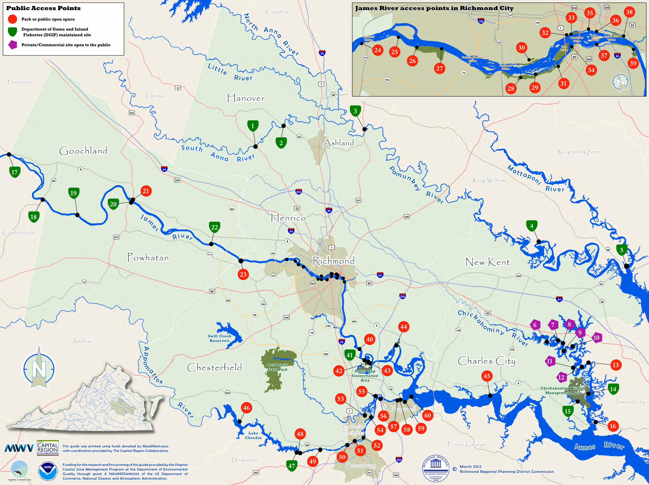
James River access points in Richmond City
Park or public open space
Department of Game and Inland Fisheries (DGIF) maintained site
Private/Commercial site open to the public
Public Access Points
Funding for the research and first printing of this guide provided by the Virginia Coastal Zone Management Program at the Department of Environmental Quality through grant # NA10NOS4190205 of the US Department of Commerce, National Oceanic and Atmospheric Administration.
This guide was printed using funds donated by MeadWestvaco, with coordination provided by The Capital Region Collaborative.
March 2012Richmond Regional Planning District Commission©
1969
CommissionPlanning District
Ric
hmond Regiona
l
PocahontasState Park
Chickahominy Wildlife Management Area
Dutch Gap Conservation
Area
Swift CreekReservoir
HenricoHenrico
R i v e r
C h i c ka
hom i n y R ive r
P
am u n key R i ve r
S o u t h A n n a R i v e r
L i t t l e R i v e r
Ma t t aponi R i v e r
J a m e s R i v e r
No
r t h Anna R
i v e r
Lake Chesdin
RichmondRichmond
GoochlandGoochland
PowhatanPowhatan
HanoverHanover
AshlandAshland
ChesterfieldChesterfield Charles CityCharles City
New KentNew Kent
Ap
po
matto x
R i v e r
King Will iam
King and Queen
Caroline
Fluvanna
Louisa
Amelia
Cumberland
DinwiddiePetersburg
Surry
Hopewell
Colonial Heights
Prince George
James City
J a me s
HuguenotBridge
Powhite ParkwayBridge
Boulevard Bridge
Lee Bridge
MayoBridge
James River Bridge
Manchester Bridge
21
17
2218
19
20
23
2
3
1
6 7
4
10
11
14
16
9
5
13
15
1245
8
5355
44
42
46
41
48
43
595756
54
5047
58
52
4951
60
40
24 2526
27
32
33 3638
3937
34
312928
30
35