river morphology - usmredac.eng.usm.my/v2/images/lecture_notes/ead511/l3... · produced by a river...
TRANSCRIPT

USM_USM_REDAC_2008REDAC_2008
River Morphology
EAD 511 River managementEAD 511 River management

USM_USM_REDAC_2008REDAC_2008
IntroductionIntroduction

USM_USM_REDAC_2008REDAC_2008
Webster's New World Dictionary defines fluvial as: of, found in, or produced by a river or rivers.
The same reference defines morphology as: any scientific study of form and structure, as in physical geography, etc. With a little guess work, we can correctly extrapolate that fluvial geomorphology is the study of the form and structure of the surface of the earth (geo) as affected by flowing water.
An equally important term is the fluvial system. A system is an assemblage of things forming a connected whole.
The primary goal on which we want to focus in this section is that you are working with a system and the complete system must be considered.
FLUVIALGEOMORPHOLOGY

USM_USM_REDAC_2008REDAC_2008
BASIC CONCEPTSSix basic concepts that should be considered in working with watersheds and rivers are:
1) the river is only part of a system,
2) the system is dynamic,
3) the system behaves with complexity,
4) geomorphic thresholds exist, and when exceeded, can result in abrupt changes,
5) geomorphic analyses provide a historical prospective andwe must be aware of the time scale, and
6) the scale of the stream must be considered.
Is the stream a small, mountain meadow trout stream, or is it the Mississippi River?

USM_USM_REDAC_2008REDAC_2008
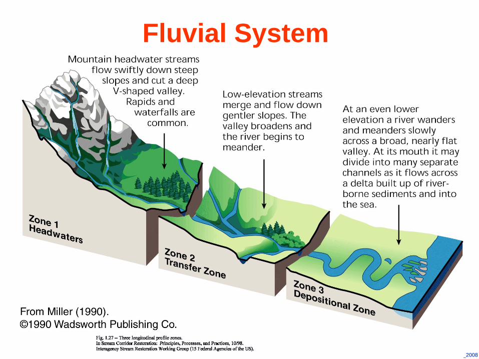
The Fluvial System (after Schumm, 1977)

USM_USM_REDAC_2008REDAC_2008
Schumm (1977) provides an idealized sketch of a fluvial system. The parts are referred to as:
Zone 1 - the upper portion of the system that is the watershed or drainage basin; this portion of the system functions as the sediment supply.
Zone 2 -the middle portion of the system that is the river; this portion of the system functions as the sediment transfer zone.
Zone 3 -the lower portion of the system may be a delta, wetland, lake, or reservoir; this portion of the system functions as the area of deposition.
THE FLUVIAL SYSTEM
USM_USM_REDAC_2008REDAC_2008
Fluvial System

USM_USM_REDAC_2008REDAC_2008
River Corridor

USM_USM_REDAC_2008REDAC_2008

USM_USM_REDAC_2008REDAC_2008

USM_USM_REDAC_2008REDAC_2008
Natural RiversNatural Rivers
Sungai Sedim, Kulim
Sungai Ulu Paip, Kulim
Sungai Kampar @ Kg Jahang,
Gopeng
Sungai Kulim, Kedah

USM_USM_REDAC_2008REDAC_2008
Nuki River (Kitakyushu City, Fukuoka Prefecture)
Before construction( October 1991 )
23 months after construction (July 1995)Sediment was deposited on which vegetation grew,
Creating a natural water space.
Rehabilitated Rivers in Jepun Rehabilitated Rivers in Jepun
Immediately after construction (August 1993)

USM_USM_REDAC_2008REDAC_2008
(a) 30th January 2003(b) 4 months after Construction
Low flow (22 Mei 2003)
High flow (19 Mei 2003)
Constructed River, Kampus Kejuruteraan USMConstructed River, Kampus Kejuruteraan USM

USM_USM_REDAC_2008REDAC_2008
Dr. Hans Albert Einstein (1972):If we change a river we usually do some good somewhere and “good” in quotation marks. That means we achieve some kind of a result that we are aiming at but sometimes forget that the same change which we are introducing may have widespread influences somewhere else.
I think if, out of today's emphasis of the environment, anything results for us it is that it emphasizes the fact that we must look at a river or a drainage basin or whatever we are talking about as a big unit with many facets.
We should not concentrate only on a little piece of that river unless we have some good reason to decide that we can do that.

USM_USM_REDAC_2008REDAC_2008
The System is DynamicZone 1 is the sediment source that implies that erosion of sediment occurs.
Zone 2 is the transfer zone that implies that as rainfall increases soil erosion from the watershed, some change must result in the stream to enable transfer of the increased sediment supply.
Zone 3 is the zone of deposition and change must occur as sediment builds in this zone, perhaps the emergence of wetland habitat in a lake, then a change to a floodplain as a drier habitat evolves.
The function of each zone implies that change is occurring in the system, and that the system is dynamic.

USM_USM_REDAC_2008REDAC_2008
From an engineering viewpoint some of these changes may be very significant. For example, loss of 100 feet of stream bank may endanger a home or take valuable agricultural land.
From a geomorphic viewpoint, these changes are expected in a dynamic system and change does not necessarily represent a departure from a natural equilibrium system.
In planning stabilization measures, we must realize that we are forced to work in a dynamic system and we must be try to avoid disrupting the system while we are accomplishing our task.

USM_USM_REDAC_2008REDAC_2008
ComplexityLandscape changes are usually complex (Schumm and Parker, 1973). We are working in a system and we have defined a system as an arrangement of things to form a whole.
Change to one portion of the system may result in complex changes throughout the system. When the fluvial system is subjected to an external influence such as channelization of part of a stream, we can expect change to occur throughout the system.
Channelization usually increases stream velocity and this would allow the stream to transfer more sediment, resulting in erosion upstream and deposition downstream of the portion of the stream channelized.

USM_USM_REDAC_2008REDAC_2008
Case 1
Some Yazoo Basin streams in north Mississippi that were channelized in the 1960s responded initially, but an equilibrium has not yet been reestablished as repeated waves of degradation, erosion, and aggradation have occurred.

USM_USM_REDAC_2008REDAC_2008
Case 2
Development of the upper Rhine.
In order to master flood damages and associated diseases, a “Rhine correction” was performed in the middle of the 20th
Century, by training the river into a straight river bed, thereby increasing the bed slope by about 30%.
This in turn gave rise to an erosion process that even today has not yet come to an equilibrium state. Also the natural river with channels and bars was changed into a normalized cross section, thus reducing the diversity of habitats.

USM_USM_REDAC_2008REDAC_2008
Thresholds
Progressive change in one variable may eventually result in an abrupt change in the system.
If a river erodes a few grains of soil from the toe of the river bank, no particular response will be noticed. If that continues with no deposition to balance the loss, the bank may eventually fail abruptly and dramatically due to undermining.
The amount of flow impinging along a bank may vary considerably with no apparent effect on the stabilization; however, at some critical point the bank material will begin to move and disastrous consequences can result.

USM_USM_REDAC_2008REDAC_2008
Channel systems have a measure of elasticity that enables change to be absorbed by a shift in equilibrium. The amount of change a system can absorb before that natural equilibrium is disturbed depends on the sensitivity of the system, and if the system is near a threshold condition, a minor change may result in a dramatic response.

USM_USM_REDAC_2008REDAC_2008
Time
Geomorphologists usually refer to three time scales in working with rivers: 1) geologic time,2) modern time, and 3) present time.
Geologic time is usually expressed in thousands or millions of years, and in this time scale only major geologic activity would be significant. Formation of mountain ranges, changes in sea level, and climate change would be significant in this time scale. The modern time scale describes a period of tens of years to several hundred years, and has been called the graded time scale (Schumm and Lichty, 1965).

USM_USM_REDAC_2008REDAC_2008
During this period a river may adjust to a balanced condition, adjusting to watershed water and sediment discharge. The present time is considered a shorter period, perhaps one year to ten years.
No fixed rules govern these definitions. Design of a major project may require less than ten years, and numerous minor projects are designed and built within the limitations of present time. Project life often extends into graded time. From a geologist’s, temporal point of view, engineers build major projects in an instant of time, and expect the projects to last for a significant period.
In river related projects time is the enemy, time is our friend, and time is our teacher. We must learn all we can by adopting a historical perspective for each project that we undertake.

USM_USM_REDAC_2008REDAC_2008
Scale
A small stream will respond more rapidly than a large stream. Different processes may dominate instability in small streams than in large streams, for example, in large rivers bank failure may primarily be driven by geotechnical failure, whereas in a small stream, bank erosion may be dominated by grain-by-grain detachment.
In addition, stabilization features that are effective on small streams may be ineffective on large streams.

USM_USM_REDAC_2008REDAC_2008
LANDFORMS
Landforms for a Meandering River (Collinson, 1978 after Allen, 1970)

USM_USM_REDAC_2008REDAC_2008
Landforms and deposits of a meandering riverine flood plain

USM_USM_REDAC_2008REDAC_2008
Classification of Valley Sediments

USM_USM_REDAC_2008REDAC_2008
A floodplain is the alluvial surface adjacent to a channel that is frequently inundated. Although much of the literature until the 1970s suggested that the mean annual flood was the bank full discharge, Williams (1978) clearly showed that out of thirty-five floodplains he studied in the U.S., the bank full discharge varied between the 1.01- and 32-year recurrence interval. Only about a third of those streams had a bank full discharge between the 1- and 5-year recurrence interval discharge. Knowledge of alluvial landforms will allow a more informed determination of bank full than depending solely on the magnitude of the flood.
Floodplain

USM_USM_REDAC_2008REDAC_2008
In stable alluvial streams, the high points on each bank represent the top of the bank full channel.

USM_USM_REDAC_2008REDAC_2008
This is the flow at which water begins to leave the channel and move onto the floodplain.
Bank full discharge

USM_USM_REDAC_2008REDAC_2008
Determination of bank full stage rom a rating curve.

USM_USM_REDAC_2008REDAC_2008
Wolman and Leopold (1957) defined bankfull stage as the elevation of the active floodplain.
Nixon (1959) defined the bankfull stage as the highest elevation of a river that can be contained within the channel without spilling water on the river floodplain or wash lands.
Woodyer (1968) suggested bankfull stage as the elevation of the middle bench of rivers having several over-flow surfaces.
Pickup and Warner (1976) defined bankfull stage as the elevation at which the width/depth ratio becomes a minimum.
Bankfull Discharge

USM_USM_REDAC_2008REDAC_2008
River MechanicsRiver Mechanics

USM_USM_REDAC_2008REDAC_2008
River mechanics is the subset of both fluvial geomorphology and open channel hydraulics which focuses on the form and structure of rivers. Specifically, it address the channel pattern, channel geometry (cross section shape), planform geometry, and the channel slope.
Rivers and streams are dynamic and continuously change their position, shape, and other morphological characteristics with variations in discharge and with the passage of time. It is important not only to study the existing river but also the possible variations during the lifetime of the project, particularly in terms of effective treatment of bank erosion.

USM_USM_REDAC_2008REDAC_2008
The characteristics of the river are determined by the water discharge, the quantity and character of sediment discharge, the composition of the bed and bank material of the channel, geologic controls, the variations of these parameters in time, and man's activities.
To predict the behavior of a river in a natural state or as affected by man's activities, we must understand the characteristics of the river as well as the mechanics of formation.

USM_USM_REDAC_2008REDAC_2008
River Equilibrium
At equilibrium, slope and flow balance the size and quantity of sediment particles the stream moves.

USM_USM_REDAC_2008REDAC_2008
Channel PatternChannel pattern describes the planform of a channel. The primary types of planform are meandering, braided, anastomosed, and straight. In many cases, a stream will change pattern within the length of the channel. The type pattern is dependent on slope, discharge, and sediment load.
The most common channel pattern is the meandering stream. A meandering channel is one that is formed by a series of alternating changes in direction, or bends.

USM_USM_REDAC_2008REDAC_2008
Relatively straight reaches of alluvial rivers rarely occur in nature. However, there are instances where a reach of river will maintain a nearly straight alignment for a long period of time. Even in these relatively straight reaches, the thalweg may still meander and alternate bars may be formed. Straight streams generally occur in relatively low energy environments.
The braided pattern is characterized by a division of the river bed into multiple channels. Most braided streams are relatively high gradient and relatively coarse streams.

USM_USM_REDAC_2008REDAC_2008
Typical Meandering River

USM_USM_REDAC_2008REDAC_2008

USM_USM_REDAC_2008REDAC_2008
Straight River

USM_USM_REDAC_2008REDAC_2008
Typical Braided River

USM_USM_REDAC_2008REDAC_2008
Pools and Crossings
As the thalweg, or trace formed by the deepest portion of the channel, changes from side to side within the channel, the momentum of the flow affects the cross-sectional geometry of the stream.
In bends, there is a concentration of flow due to centrifugal force. This causes the depth to increase at the outside of the bend, and this area is known as a pool.
As the thalweg again changes sides below a bend, it crosses the centerline of the channel. This area is known as the riffle or crossing.

USM_USM_REDAC_2008REDAC_2008
Features Associated With (a) Straight and (b) Meandering Rivers

USM_USM_REDAC_2008REDAC_2008

USM_USM_REDAC_2008REDAC_2008

USM_USM_REDAC_2008REDAC_2008
The cross section in a bend is deeper at the concave (outer bank) side with a nearly vertical bank, and has a shelving bank as formed by the point bar on the convex side.
The cross section will be more trapezoidal or rectangular in a crossing.
Cross Section Shape

USM_USM_REDAC_2008REDAC_2008
Typical Plan and Cross Sectional View of Pools and Crossings

USM_USM_REDAC_2008REDAC_2008

USM_USM_REDAC_2008REDAC_2008

USM_USM_REDAC_2008REDAC_2008
Channel Bars.
Channel bars are depositional features that occur within the channel. The size and location of bars are related to the sediment transport capacity and local geometry of the reach. The enlargement of a bar generally results in caving of the opposite bank in order to maintain conveyance of the discharge.
The primary types of bars are point bars, middle bars, and alternate bars.

USM_USM_REDAC_2008REDAC_2008
Point Bar(Connected to banks)

USM_USM_REDAC_2008REDAC_2008
Typical Middle Bar (Not connected to banks)

USM_USM_REDAC_2008REDAC_2008
Typical Alternate Bar Pattern(Positioned successively down the river on opposite sides)

USM_USM_REDAC_2008REDAC_2008
Definition Sketch for Channel Geometry(after Leopold et al., 1964)
Planform Geometry.

USM_USM_REDAC_2008REDAC_2008
Channel Slope
The product of discharge (Q) and slope (s) is defined as stream power (= Q X S). Both discharge and slope are extremely significant parameters in the study and understanding of river behavior
Slope is one of the best indicators of the ability of the river to do work. Rivers with steep slopes are generally much more active with respect to bank erosion, bar building, sediment movement, etc., than lower slope channels.

USM_USM_REDAC_2008REDAC_2008
Slope can be defined in a number of ways.
If sufficient data exists, the water surface slope maybe calculated using stage readings at gage locations along the channel.
However, in many instances, particularly in small streams, gage information is non-existent. In these cases, the thalweg slope is generally calculated. Thalweg refers to the deepest point in a cross section. The thalweg slope not only provides a good expression of the energy of the stream, but also may aid in locating areas of scour and fill, geologic controls, and outcrops of non-erodible materials.

USM_USM_REDAC_2008REDAC_2008
Relationships in Relationships in RiversRivers

USM_USM_REDAC_2008REDAC_2008

USM_USM_REDAC_2008REDAC_2008
Leopold and Wolman’s (1957) Relationship Between Channel Patterns, Channel Gradient,
and Bank full Discharge

USM_USM_REDAC_2008REDAC_2008
van den Berg (1995) Relationship Between Stream Power and Median Grain Size

USM_USM_REDAC_2008REDAC_2008
Channel Channel ClassificationsClassifications

USM_USM_REDAC_2008REDAC_2008
Stable or Graded ChannelA stream may then be classified as either stable or unstable. A channel that has adjusted dependent variables to accommodate the basin inputs (independent variables) is said to be stable. Mackin (1948) gave the following definition of a graded or stable stream:
A graded stream is one in which, over a period of years, slope is delicately adjusted to provide, with available discharge and with prevailing channel characteristics, just the velocity required for the transportation of the load supplied from the drainage basin. The graded stream is a system in equilibrium.

USM_USM_REDAC_2008REDAC_2008
River Equilibrium
Lane relationship

USM_USM_REDAC_2008REDAC_2008
A stream in dynamic equilibrium has adjusted its width, depth and slope such that the channel is neither aggrading nor degrading. However, change may be occurring in the stream bank, erosion may result, and bank stabilization may be necessary, even on the banks of a stream in dynamic equilibrium. In the context of stream rehabilitation, a stable stream is a graded stream in dynamic equilibrium.

USM_USM_REDAC_2008REDAC_2008

USM_USM_REDAC_2008REDAC_2008
Channel Classification Based on Pattern and Type of Sediment Load (after Schumm, 1981)

USM_USM_REDAC_2008REDAC_2008
Classification of Alluvial Channels (after Schumm, 1977)

USM_USM_REDAC_2008REDAC_2008
Summary of Delineative Criteria for Broad-level Classification(Rosgen, 1994)

USM_USM_REDAC_2008REDAC_2008
Channel Classification Combining Aspectsof Schumm (1981) and Rosgen (1994)

USM_USM_REDAC_2008REDAC_2008
Back to NatureBack to Nature

USM_USM_REDAC_2008REDAC_2008
Restored channel of the Itach River, Japan(Meandering channel with a middle bar)

USM_USM_REDAC_2008REDAC_2008
Nuki River, Japan23 months after construction (July 1995). Sediment was deposited on which vegetation grew, creating a natural water space

USM_USM_REDAC_2008REDAC_2008
Itabitsu River after improvement