river 5 avon circular walks trailriveravontrail.org.uk/booklet.pdfport of bristol, the beautiful...
TRANSCRIPT

Pi l l - Avon Gorge - Br is to l - Bath
circular
gu ide
+RiverAvonTrail
5walks

Key to map sections

1River Avon Tra i l
This booklet aims to provide youwith a comprehensive guide to
the 23 mile River Avon Trail.
The Trail, which used to be known asthe Avon Walkway, has been upgraded sothat much of it can now be used by cyclists, as well aswalkers. The section between Conham and Hanham is apublic bridlepath, permitting horse riding.
The River Avon Trail is described here from west to east butit can just as easily be walked in the other direction, or insections. Many connecting paths and trails can also beaccessed from the route.
The Trail passes through the historic harbour village of Pill,the spectacular Avon Gorge, the modern city and ancientport of Bristol, the beautiful countryside where the AvonValley meets the Cotswold Hills and ends at the famousPulteney Bridge in the Georgian city of Bath. Although theTrail goes no further, the river continues upstream to itssource near Sherston in the Cotswold Hills.
The Avon is a fascinating river. It was the great highway ofthe area, stimulating trade and industry. The river corridorhas a complex geology and offers a rich and variedenvironment for wildlife, containing some unique species.
For further information about the River Avon Trail, pleasevisit www.riveravontrail.org.uk
To ask questions or post top tips on the website pleaseemail: [email protected]: 0117 953 2141
Ordnance Survey Explorer maps 154 & 155 cover thelength of the Trail.
Welcome
www.riveravontrail .org.uk

2
Not just for walkers...
Cycling in the Avon ValleyMuch of the Trail coincides with the National Cycle Network(Routes 3 and 41) and can mostly be cycled from Pill toHanham. The individual map pages show where you will needto walk your bike, take a diversion or exercise extra cautionwhere bank erosion is under-cutting the path or improvementsare needed. You can easily connect with the Bristol & BathRailway Path to continue to Bath.
Horse Riding in the Avon ValleyHorse riding is currently limited to the public bridlepathsection of the Trail between Conham and Hanham. The newlydesignated Avon Valley Woodlands Local Nature Reserveborders much of this section. The woodlands are subject to anumber of proposals for improving wildlife and amenity value.It is hoped that as part of this work, an additional permissivebridlepath can be established to create a horse riding circuit inthis area.
Wheelchairs and PushchairsSome sections of the River Avon Trail are suitable for peopleusing wheelchairs or pushchairs. There are three locations inparticular where you can enjoy a trip along the river:
Conham River ParkDisabled parking and toilets available. From here you can headsouth along the riverside to Beese’s Tea gardens (summer only)via Conham Ferry and admire the surrounding woodlands andfields. The route can be wet and muddy in winter.
The Avon GorgeThere are several car parks at the west end of CumberlandRoad in Bristol which provide easy access to the River AvonTrail via the CREATE Centre car park. There are then goodquality paths along the river through Brunel Way Picnic Park.You can continue along the edge of Leigh Woods forwonderful views of the Clifton Suspension Bridge and theAvon Gorge. One steep ramp exists at the north-west end ofthe Park.
BathMuch of the Trail can be visited as there are a number oframped access points and the route itself is over one metrewide with good quality surfaces.

3River Avon Tra i l
Getting There
Public TransportThe Trail can be reached from train stations at Bristol TempleMeads, Bath and Keynsham. For details:Tel: 08457 484950 or visit: www.nationalrail.co.uk
Ferry boat companies operate regular and occasionalservices, mainly from the Bristol Harbour area:Bristol Ferry Boat Co: 0117 908 3121 or visit: www.bristolferryboat.co.ukThe Bristol Packet: 0117 926 8157 or visit: www.bristolpacket.co.uk
Main bus stops are marked on individual map pages. For bus information contact Traveline: 0870 608 2608 orvisit: www.traveline.org.uk
Refreshments & FacilitiesThere are no facilities in the Avon Gorge, between TempleMeads Station and Conham or between Saltford andNewbridge. There are cafes and eateries close to the Trail inPill, Bristol and Bath, and pubs at Hanham, Keynsham andSaltford. Places to stop along the other sections are markedon the separate map pages.

4
At Avonmouth the difference between high and lowtide can be as much as 40 feet (12.3 metres) – the
second highest tidal range in the world. With eachrising tide enormous volumes of water push into themouth of the river from the Bristol Channel, only toflow out again a few hours later.
Once the tides pushed all the way up to Bath, the riverrising and falling with every tide. But the constructionof a number of mills, with weirs across the river, in the13th century impeded both the tides and trade alongthe river between Bristol and Bath.
Today the river is tidal as far as the Netham Weir closeto St Anne’s on the eastern edge of Bristol. Thisbarrage can be overtopped by very high tides.
The village of Pill was famous for the skill of its pilots,who used their knowledge of the tides and currents ofthe Bristol Channel to guide ships safely to the mouthof the Avon.
But the journey up the river to Bristol was no lessarduous. Ships had to be towed upriver on the risingtide and safely moored before the ebb. At low tide shipshad to rest on the river bed. The journey for a shipbeing towed from Pill to Bristol could take a week.
The River and the Tides
left & right: Pill Creekat low and high tide -looking across theAvon toShirehampton.
below left: Complexpatterns in the mudcreated by the flux ofthe tide.
below: Oystercatcher -low tide is a busytime for wading birdswho search formolluscsandworms in themud.

5River Avon Tra i l
left: Read more local stories on the15 interpretation boards along theRiver Avon Trail. The boards revealmore of the heritage, wildlife,geology and legends surroundingthis historic waterway.
Looking down Pill Creek towards the Lamplighters pub onthe Shirehampton side. When pub closing time was half anhour earlier in Gloucestershire than it was in Somerset, aregular contingent from Shirehampton took the ferry to Pill for a last drink. The ferry was often so crowded that the passengers had to sway to give the ferryman room to row.

6
AvonGorgeWhy is there a gorge
here at all? Therewould seem to be far easierways for the Avon to reachthe sea.
It is thought that the riverwas diverted from itsoriginal course by walls ofice which were formedduring the Ice Ages.
Blocked by ice and highground the river wore itsway through hard limestoneand sandstone rocks –making the Gorge. In sodoing it created a uniquehabitat.
The Gorge has a micro-climate that is a degree or sowarmer than thesurrounding landscape. Thesteep rocky slopes of theGorge have preserved thisunique wilderness at theedge of a busy city.
Species of plants havesurvived in the isolatedwooded and grassy areas ofthe Gorge that have eitherdisappeared or are very rarethis far north (such as theautumn squill – below left).Others have continued toevolve in the isolation of theGorge, so that they are nowunique versions of theirspecies.
above: The Avon Gorge inforbidding mood.
below: Scurvy grass – acommon plant thatflourishes in saltyconditions. Once it wasvalued as a remedy forscurvy and gathered to betaken on sea voyages - itcontains vitamin C.
bottom: The rare autumnsquill. When Brunel wastold that the building ofhis suspension bridgethreatened a colony ofthese plants he arrangedfor them to be removed toa safer location.
right: Peregrinefalcons havereturned tohunt and breedin the Gorge.

7River Avon Tra i l
The Avon Gorge and the river’s tides provided theearly city of Bristol with natural protection. Any
invader would be hopelessly vulnerable and probably getstuck trying to reach the city by coming up the river.
But as ships got larger, serious accidents, such as the onebelow, became more frequent. Wrecks could block theriver for months, threatening the viability of the port.
above: Labour of a lifetime – Brunel won the competition todesign the Clifton Suspension Bridge in 1831, when he wasonly 25. But it was not begun until 1836 and then afterfurther delays, not completed until 1864, five years afterBrunel’s death. This painting from Samuel Jackson’ssketchbook celebrates Bristol’s most famous view.
below: The wreck of the Gypsy in 1878, wedged across theriver, her back broken by the tide.
Gateway to Bristol

The medieval port andcity of Bristol
grew rich exportingEnglish wool andwoollen cloth toEurope. The principalimport was wine fromFrance.
By the mid 18th century,the patterns of trade hadchanged and Bristol wasprospering on trade withWest Africa, the West Indiesand North America.
Brassware produced in theBristol area, as well as othergoods, were traded inAfrica for ‘enslaved’ people.They were taken across theAtlantic to work on thesugar, cotton and tobaccoplantations of the NewWorld. These commoditieshad a ready market inEurope.
But the narrow, tidalharbour that madeBristol England’ssecond port began aslow decline. Ships grewlarger and trade was lost toother ports.
The opening of the FloatingHarbour in 1810 extendedthe life of the port, but itwould never regain itsformer status.
The port declined rapidly inthe late 1960s and closedin 1977. The docks area isnow mainly used forrecreation and housing.
Bristol
above, left & below:Black-headed, herringand lesser black-backedgulls all find a living inthe harbour area.
above: Dockside cranessuch as these listedstructures are remindersof the working port.
Find out moreabout thedocks andBristol’smaritime historyat BristolIndustrial Museum.
8

The Industrial River
In 1810 the Floating Harbour was opened. Lock gatesisolated the docks from the ebb and flow of the tide.
The flow of the river was diverted along the New Cut. TheFeeder Canal created a new extension to the harbourcomplex to the east. New areas of land became accessiblefor commercial and industrial development.
The power of the river had long been exploited by the 30or so water mills between Bristol and Bath – most ofwhich were in the service of the brass industry in the18th century. But in the 19th century the new steam-powered technology, utilising the ample supply of localcoal, triggered massive industrial development along theFeeder Canal and across St Philip’s Marsh.
below: The Great Western Locomotive & Wagon Works closeto Temple Meads shows the intensity of land use. Besidesheavy engineering there were iron, lead, chemical and tarworks as well as cotton and board mills in the area.
above: The chimney on Troopers Hill, a relic of thecopper smelting industry.
River Avon Tra i l 9

above: A spectacular viewfrom The Panorama Walk(see p. 21) off the RiverAvon Trail at Conham.
Look for the tunnel andcuttings built to supportBrunel’s Great WesternRailway near Conhamwhen you hear the rush ofmodern trains.
left: Saltford Lock waswrecked by local minersin 1738. They feltthreatened by the cheaperShropshire coalbrought in alongthe Avon.
right: Keynsham –The deepest and mostdangerous lock on theTrail is No. 2 on theKennet & Avon Canal.
Avon ValleyWoodlands
Regenerated woodland,with other varied
habitats make this LocalNature Reserve a haven forwildlife. Trees have reclaimedthe quarried rock faces thatscarred the steep slopes ofthe Gorge from Conham toHanham. The trees alsoconceal the spoil left byseveral centuries of copperand brass making activity.
Conham River Park is a goodplace for a walk, a picnic –or, in summer, take Conhamferry across the river toBeese’s Tea Garden andEastwood Farm. This isanother piece of restoredland where you can enjoywalks through woods andwater meadows to seeherons and other water birds.
10
11River Avon Tra i l
AvonNavigation
The economic prospectsof the area boomed
when the stretch of waterbetween Hanham and Bathwas opened for navigation.Six locks were built tocontrol the tidal river andconduct boats uphill andupstream to Bath.
The first barge sailedupstream from Hanham in1727. Almost a centurylater this lock was tobecome the first of over100 on the Kennet & AvonCanal, linking the regionwith London.
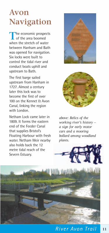
Netham Lock came later in1809. It forms the easternend of the Feeder Canalthat supplies Bristol’sFloating Harbour with freshwater. Netham Weir nearbyalso holds back the 12metre tidal reach of theSevern Estuary.
above: Relics of theworking river’s history – a sign for early motorcars and a mooringbollard among woodlandplants.

CotswoldEdge
The northern slopes ofthe Avon Valley,
between Saltford andBath, form the edge of theCotswold Hills.
The Cotswold scarp has along history of use fordefence purposes. Theearthworks from a seriesof Iron Age hillfortsremain and the Battle ofLansdown took placebeyond the scarp in 1643.
Roman presence in thearea is marked by sites inboth the hills and theAvon Valley at Keynshamand Newton St Loe as wellas most famously, at Bath.
The typically English riverlandscape in theNewbridge area hasremained relativelyuntouched for severalcenturies, despite road andrailway building.
above: The charmingCotswold villages ofNorth Stoke and Kelstonare accessible from theRiver Avon Trail.
left: Cotswold spring-water bound for theRiver Avon.
below: The copse on topof Kelston Round Hillcan be seen for miles.Further west is the siteof the Little Down IronAge hillfort.
12

13River Avon Tra i l
Bath
Although the Avoncontinues upstream
to its source in theCotswold Hills, the RiverAvon Trail ends here.Pulteney Weir is the Headof the Avon Navigationbeyond which no boatsmay pass.
The part the River Avonhas played in the successof this famous city hasbeen little recognised.
But as you reach the endof the River Avon Trail,you can still see what little remains of the mills, factories andwarehouses of the working city.
below: The Romano-Celtic head from thepediment of the Templeof Sulis Minerva at theRoman Baths, Bath.Geologists think thatBath’s spa water may belinked to the nowuntapped spa water ofHotwells, Bristol.
above: Robert Adams’ famous Pulteney Bridge (1773) wasbuilt in one of the area’s great exports – Bath Stone.

14
Pill • Ham Green • Horseshoe Bend • Miles Dock
map © Crown Copyright. South Gloucestershire Council Licence No. 100023410, 2004
RouteInformation:
Loose stone or hardsurfaces at least 1 metre wide,
with the exception of a shortsection on the north side of
Leigh Woodswhich is narrower
and winding.

map 1
right: The Powder House. At one time all shipsbound for Bristol CityDocks had to surrenderany gunpowder orother material thatmight fuel a fire among the wooden shipsmoored inside the crowded harbour. These materials were stored here– to be reclaimed on the outwardjourney.
15River Avon Tra i l

16
Miles Dock • Avon Gorge • Cumberland Basin
Loop Walk 1
Route Information:Loose stone or hardsurfaces at least 1 metrewide, with the exceptionof a short section on thenorth side of Leigh Woods
which is narrowerand winding.
Paradise Bottom(2 miles / 3 kms)
Enjoy this walk through thewild and dramatic valley scenery of
Leigh Woods. The woodlands were created in the 19thcentury as part of the Leigh Court estate. Close by, andworth a detour, is The Grotto. The woods have beensensitively restored and are now sustainably managed.
below: View from The Grotto.

map 2
above: The diagonal strata ofthe limestone can be clearly
seen in the exposed rockfaces of the Avon Gorge.
These were originallyancient seabeds,
horizontal when theywere laid down around350 million years ago.
17River Avon Tra i l

Bristol City Docks • Bristol Bridge • Temple Meads
Loop Walk 2
Merchants’ Walk (2 miles / 3 kms)
This walk follows thestreets of the medieval
city, visits buildingsof the Georgian era,
the regenerateddockside warehousesand the place where
the city began – Bristol Bridge.
right: Brunel’soriginal swingbridge, built in1848 – under
the modernroad bridge.
Explore the entranceto the Floating Harbour.
The harbour is part of theoriginal course of the Avon –
isolated from the ebb and flowof the tides by these lock gates in
the early 19th century.
18

19River Avon Tra i l
map 3
left: Take the opportunityto visit St Mary Redcliffe -built with the wealth ofBristol’s medievalmerchants, who hadgrown rich exporting finequality English wool andwoollen cloth.
Route Information:This 4 mile long urban section is all onpaths with hard surfaces or pavements.
The route is surprisingly pleasant – as muchof it is away from roads – in Bristol’s parks oralong the historic waterfront. There are steps atVauxhall Bridge, Castle Park and Temple Meads
Station that could be avoided with short diversions. Cyclists will need to dismount where the
Trail passes through Temple Meads Station.
right:A longway fromhome - afig treegrows out ofthe harbour wall at theedge of Castle Park. It isthought that the seed mayhave arrived by ship, over
a century ago.

Netham • Crew’s Hole • Avon Valley Woodlands
20
Panorama Walk (1.5 miles / 2 km) Climb the 'hundred steps' to be rewarded withspectacular views of the River Avon and its steepwooded valley. This short circular walk passes throughthe Avon Valley Woodlands Local Nature Reserve, whichincludes sites of important industrial archaeology,reminding us of the rich natural resources that once laidbeneath our feet and made this a busy place.
Loop Walk 3
Route Information: All off-road, on hard surfaces or
loose stone paths at least 1 metrewide except between the east end of
St Philips Causeway and Netham Parkwhere the path is narrow, poorly
defined and overgrown, especially in summer.

map 4
Cyclists will need to take a short diversion at the eastend of St Philips Causeway. Cross St PhilipsCauseway, pass the KFC fast food outlet
and ride along the cycle track to Feeder Road which will lead back
to the Trail atNetham
Park.
21River Avon Tra i l
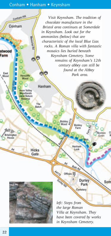
Conham • Hanham • Keynsham
Visit Keynsham. The tradition ofchocolate manufacture in the
Bristol area continues at Somerdalein Keynsham. Look out for theammonites (below) that arecharacteristic of the local Blue Liasrocks. A Roman villa with fantastic
mosaics lies buried beneathKeynsham Cemetery. Some
remains of Keynsham’s 12thcentury abbey can still be
found at the AbbeyPark area.
22
left: Steps from the large Roman Villa at Keynsham. Theyhave been covered by worksin Keynsham Cemetery.

23River Avon Tra i l
map 5
Route Information: This section is all off-road,on stone paths or field footpaths at least 1metre wide except where tidal floods areeroding sections of the river bank one mile westof Hanham.
Cyclists and horse riders in particular, should beaware of these sections. The path here can bewet and muddy in bad weather. Cyclists wishingto continue from Hanham to Bath should take a
short detour up the lane from the ChequersInn car park. A right turn at the junctionleads on to the A431 to Bitton. Followsigns to Bitton until you pick up theBristol & Bath Railway Path at BittonStation, which then provides wonderfulviews of the surrounding countryside
before rejoining the River Avon Trail west of Bath.

Keynsham • Swineford • Saltford
North Stoke Circular (4 miles / 6km)A detour to Swineford along the north side of the RiverAvon will lead you to a scenic climb up to the prettyvillage of North Stoke. This walk passes along a lovelyold byway with beautiful views across Pipley Bottom andoffers a spectacular panorama of the Avon Valley fromthe little church at the top of the village.A short walk further leads you to Little Down Hill Fort –one of a series along the Cotswold scarp (see OSExplorer 155 map).
Loop Walk 4
24
Route Information: This rural section isnearly all along field footpaths which can
be wet and muddy. The Trail is stile freeexcept for a short section at Holm Mead, west
of the Bristol & Bath Railway Path. There are steps at the Railway Path.

map 6
above: After the climb – the church atNorth Stoke, with fine views
across the Avon Valley.
25River Avon Tra i l

Saltford • Kelston • Newbridge
left: One of over30 mills that wereonce powered by theAvon. Saltford BrassMill is one of the mostimportant survivingremains of the brassindustry in England.Tel: 0117 986 2216for opening times orvisit:www.brassmill.com
26
There are steps at Saltford MarinaandNewbridge.
Route Information: This rural section isnearly all along fieldfootpaths which can bewet and muddy.

below: Looking downstream fromSaltford, the edge of the Cotswolds rise above
the river. To the right you can see two towers– all that remain of
Kelston BrassMill’sfurnaces.
map 7
27River Avon Tra i l

right: Widcombe Lockmarks the junctionbetween the River Avonand the Kennet & AvonCanal. From 1810, whenit opened, until thearrival of the railway,this was the main tradelink between Bristol andLondon.
Newbridge • Locksbrook • Bath
Route Information: A 3 mile section of generally goodlevel surfaces of stone or tarmac at least 1 metre wideleading right into the centre of Bath.Steps at Churchill Bridge and
PulteneyBridge.
Thissection
provides a useful link forcyclists between the Bristol& Bath Railway Path andthe Kennet & Avon CanalTowpath which continuesinto Wiltshire along apeaceful, off-road routewith waterside views.
28

map 8
Beechen Cliff (1.5 miles / 2 kms)
Take a walk up the steep slopes of Beechen Cliff –“that noble hill whose beautiful verdure and hangingcoppice render it so striking an object from almostevery opening in Bath.” (Jane Austen, NorthangerAbbey). Don’t miss the views over the city andthe beautiful mature beech trees.
left: Bath Abbey from Beechen Cliff.
Loop Walk 5
29River Avon Tra i l

30
Working with Schoolsand the Community
Local KnowledgeThis project – the creation of 15 interpretation boards, aguide book and a website to promote the River Avon Trail –also acted to forge local links with the communities who liveand work along the river.
In early 2004, a numberof local meetings wereheld to explain theproject. Greatenthusiasm andgenerosity wereencountered. Theproject also published abi-monthly newsbulletin.
The project consultedwith local history andconservation societiesto arrange andadvertise localdiscovery walks, hostedand led by people fromthose groups.
Working with SchoolsIn the summer 2004, school projects were also arranged. Theseused local knowledge as a basis for cross-curricular workshops.
left: TheNational Trustand the AvonGorge andDownsWildlifeProject set upactivitiesinvolving over
70 local schoolchildren to explore and celebrate thenatural history of the Avon Gorge. With the help of theAvon Wildlife Trust, the children created artwork whichformed an enormous banner displayed on the largegraffiti-covered rock above the River Avon Trail.

31River Avon Tra i l
right: After collecting anumber of local storiesat Pill Regatta, J19,Pill’s amateur dramagroup, visited CrockernePill Primary Schoolwhere the stories wereretold as drama andgames. The childrenwent on to createartwork from their experiences in a printing workshop.To see the book visit: www.riveravontrail.org.uk
below: At Saltford BrassMill, children fromSaltford Primary Schoolworked with artists tointerpret both the flowingriver and its wildlife aswillow sculpture. This wasarranged as part of DoorsOpen Day at the BrassMill. There were recordnumbers of visitors. Allparties are looking forwardto repeating the experiencenext year.
below: Children at BartonHill Nursery & InfantSchool worked with ananimator. The theme of theanimation was the river andthe transformation of thearea. This project wasorganised as a collaborationwith Community at Heartand Barton Hill LocalHistory Group. See theanimation on the website orat:www.electricdecember.org.uk

32
Who Manages the Trail?
Avon Valley PartnershipThis booklet was published by the Avon Valley Partnershipwith funding from the Heritage Lottery Fund. ThePartnership comprises local authorities and environmentalorganisations with an interest in improving theenvironment and enjoyment of the Avon Valley. Forinformation and queries regarding the River Avon Trailplease contact the AvonValley DevelopmentOfficer: 0117 922 4325.
Forest of AvonThe Forest of Avon partnership connects people to trees,timber and woodlands by enhancing natural environmentsclose to local communities. This includes several projects inthe Avon Valley to improve recreational routes such as theRiver Avon Trail and the Community Forest Path, and tocreate new woodlands. One such woodland at SydenhamMead, north of Keynsham, was recently planted with thehelp of local schoolchildren whilst the larger Manor RoadCommunity Woodland, to the west of Saltford, is managedby Bath & North East Somerset Council and the localcommunity. Contact the Forest ofAvon: 0117 953 2141 or visit thewebsite atwww.forestofavon.org.uk for moredetails.
Picture Credits
All illustrations by Lindy ClarkAll photographs by Liz Milner and Peter Milner, except for:Cover: Pulteney Bridge - Miriam Woolnough (B&NES Council)Page 6: Scurvy Grass - Pat O’Reilly; Autumn Squill - AGWP(Helen Hall)Page 7: Samuel Jackson painting - Bristol Record Office; Wreck of the Gypsy - John Rich CollectionPage 9: Troopers Hill - Friends of Troopers Hill; Aerial view Wagon Works - Tozer CollectionPage 12: Romano-Celtic Head - photographer unknown; Pulteney Bridge - Miriam Woolnough (B&NES Council)Page 27: Saltford Brass Mill - Friends of Saltford Brass Mill
written, researched and designed by C&M Associates: Ruth Coleman & Peter Milner
© Avon Valley Partnership 2004Printed on greencoat velvet paper – 75% recycled / 25% virgin pulp

33
The National TrustThe National Trust protects places ofhistoric interest or natural beautyfor everyone to enjoy forever. Itowns and manages Leigh Woods
with the Forestry Commission. There are many trailsyou can explore in this lovely National Nature Reserveby foot or by bike. For more information and a freeleaflet about Leigh Woods contact: 0117 973 1645.
The Avon Gorge & Downs Wildlife ProjectThis project is working to secure theoutstanding wildlife interest of theBristol side of the Avon Gorge andthe Clifton and Durdham Downs andto raise awareness andunderstanding of this unique
location and its importance for people and wildlife.Contact 0117 903 0609 – or for more information,visit: www.bristolzoo.org.uk/conservation/avonpage
North Somerset Council North Somerset Council ownsLower Rownham Hill and manages
the site with the help of the National Trust andTreedom. This pleasant site next to the River Avon Trailoffers great views over the River Avon and Hotwellsand a new path runs through the site linking the Riverto the Clifton Suspension Bridge.
If you encounter any obstacles along the River AvonTrail please report them to:Tel: 0117 922 4325.
NorthSomerset
C O U N C I L