revised edwards aquifer recharge zones map - city of … · · 2017-05-11this customer bulletin...
TRANSCRIPT

CB 117 – City of Georgetown Water Quality Regulations Page 1 of 5 Revised: May 10, 2017
TO: Planning and Inspection Services departments Customers SUBJECT: Customer Bulletin #117 –Water Quality Regulations for property in the Edwards
Aquifer Recharge Zone DATE: March 11, 2015, revised May 10, 2017
This Customer Bulletin was created as a customer service initiative to property and business owners located over the Edwards Aquifer Recharge Zone (“EARZ”) within the City limits and its Extraterritorial Jurisdiction (“ETJ”) on the City’s Water Quality Regulations (Section 11.07 of the Unified Development Code (“UDC”)) and the Federal standards outlined in UDC Appendix A relating to the Georgetown Salamander Occupied Sites. The purpose of the Regulation is to safeguard the stream and spring formations of the EARZ, and protect water quality. A location map of the EARZ is available online in the City’s website at https://maps.georgetown.org/interactive-maps/ (Edwards Aquifer Recharge Zones Map).
On August 7, 2015, the United States Fish and Wildlife Service (“USFWS”) published the 4(d) special Rule for the Georgetown salamander, effective September 8, 2015. This Rule enables development activity to continue if they are in compliance with the City’s Water Quality Regulations (UDC Section 11.07) and federal standards pertaining to the identified Occupied Sites (UDC Appendix A). With the 4(d) special Rule accepting the City of Georgetown Water Quality Regulations, stakeholders have the benefit of consistent and objective criteria for developing land in the EARZ without the need for site-specific determinations by the USFWS.
Changes to the City’s development process include (1) the submittal and acceptance of a Geologic Assessment (“GA”) by the City’s Development Engineer for all current and future development activities (Regulated Activity), and (2) a signed and notarized Water Quality Acknowledgement Form.
The Water Quality Regulations do not apply to property over the Edwards Aquifer Contributing Zone (“EACZ”). However, due to the listing of the Georgetown Salamander, development over the EACZ may be subject to additional requirements. Consequently, stakeholders wishing to develop property over the EACZ are encouraged to contact the USFWS for applicable requirements prior to developing the property.

CB 117 – City of Georgetown Water Quality Regulations Page 2 of 5 Revised: May 10, 2017
REGULATED ACTIVITY In accordance with the Water Quality Regulations (UDC Section 11.07.002) and Section 213.3(28), Title 30, of the Texas Administrative Code (“TAC”), Regulated Activity is “any construction-related or post-construction activity on the recharge zone of the Edwards Aquifer having the potential for polluting the Edwards Aquifer and hydrologically connected surface streams.” These activities include, but are not limited to: Construction of buildings, utility stations, utility lines, roads, highways, or railroads; or Clearing, excavation, or any other activities that alter or disturb the topographic, geologic,
or existing recharge characteristics of a site; or Any other activities that may pose a potential for contaminating the Edwards Aquifer and
hydrologically connected surface streams. Regulated Activity does not include: Clearing of vegetation without soil disturbance; Agricultural activities; Routine maintenance of existing structures that does not involve additional site
disturbance; and Construction of single-family residences on lots larger than five (5) acres, where no more
than one (1) single-family residence is located on each lot.
For a detailed definition and complete list of Regulated Activity please refer to Section 213.3(28), Title 30, of the TAC, available online at http://info.sos.state.tx.us/pls/pub/readtac$ext.viewtac.
GEOLOGIC ASSESSMENT (GA) The purpose of a GA is to identify any potential issues or habitat that may affect the development of an individual property or site. The GA must contain all of the information required by TAC Section 213.5, and the following: Identification of all Springs and/or Streams on a site, or the certification that no Springs or
Streams exist on the site; Description of any Spring and/or Stream on a site, including the location of any Spring
outlet or Stream; For identified Occupied Sites (Exhibit A), the No-Disturbance Zone (“Red Zones”) and the
Minimal-Disturbance Zone (“Orange Zones”) (Exhibit B) should be identified and delineated in the GA in accordance with UDC Appendix A.
It is important to note that all zones and buffers must be graphically depicted on all Subdivision Plats, Site Plan and infrastructure construction plans. A note certifying that the proposed development is subject to the Water Quality Regulations, and that a GA was completed (if applicable, see exemption criteria below) must also be included in the Subdivision Plat, Site Plan and construction plans.

CB 117 – City of Georgetown Water Quality Regulations Page 3 of 5 Revised: May 10, 2017
A copy of the GA must be submitted with the first required development application for all Regulated Activity. Required development applications may include Plats (Preliminary, Final, Minor, Amending and Replat), (Subdivision) Construction Plans, Site Development Plans, and Stormwater Permits. The first required development application will be determined by the scope of work and any pre-approvals received prior to the issuance of this Customer Bulletin.
Subsequent applications required to develop the property will not require a new GA provided the proposed development, as submitted in the application, is consistent with the accepted GA. Any deviations to the proposed development will result in the need to submit an updated GA prior to final approval of the application.
In addition to the above, new Single-Family Residential (“SFR”) and Two-Family Residential (“TFR”) uses to be developed on property exempt from the Platting requirements of the City’s Unified Development Code (“UDC”), must submit a GA with the application for a Building Permit.
SFR and TFR developments of a platted subdivision must meet the water quality measures of the Water Pollution Abatement Plan (“WPAP”), as approved by the Texas Commission on Environmental Quality (“TCEQ”), for the subdivision and associated public improvements including water, waste water and drainage facilities, and streets. New water quality measures are not required, provided each lot is built in accordance with the approved WPAP. Therefore, new SFR and TFR located within a platted subdivision and where all public improvements were completed and accepted by the applicable jurisdiction, will not require the submittal of a GA with the Building Permit application. However, should the lots within a platted subdivision be altered through the Subdivision Plat, Amending Plat or Replat process, or the proposed development deviates from the approved WPAP, a GA will be required prior to approval of the application, unless it meets the exemption criteria listed below.
EXEMPTIONS Certain small projects may be exempt from the Geologic Assessment requirements. To qualify for this exemption, a project must meet all of the following criteria: Proposed development is SFR or TFR; and Subject property is located on an individual lot that is less than 5 acres; and Subdivision (to include replat) is 5 lots or less, and no more than 5 gross acres; and Subject property is located within a drainage area that is less than 64 acres.
Projects that meet all of the criteria above must submit with the required application a letter signed by an Engineer certifying the drainage area and identifying any springs on the subject property. In the event that springs exist, the project Engineer must identify applicable buffers on the site/plot plan.

CB 117 – City of Georgetown Water Quality Regulations Page 4 of 5 Revised: May 10, 2017
WATER QUALITY ACKNOWLEDGEMENT FORM In order to facilitate the review of development applications in accordance with the Water Quality Regulations, a signed and notarized Water Quality Acknowledgement Form (“Acknowledgement Form”) (Exhibit C) is required to be submitted with the a required development application for all new Regulated Activity, in addition to the GA.
The purpose of the Acknowledgement Form is for a property owner, or his/her representative, to certify compliance with the City’s Water Quality regulations or that coordination with USFWS will occur, as applicable.
As with a required GA, subsequent applications required to develop the property will not require a new Acknowledgement Form provided the proposed development, as submitted in the application, is consistent with the accepted Acknowledgement Form and GA (when applicable). Any deviations will result in the submittal of a new Acknowledgement Form (and GA when applicable) prior to final approval of the application.
In addition to the above, new SFR and TFR uses to be developed on property exempt from the Platting requirements of the City’s UDC, must submit an Acknowledgement Form with the application for a Building Permit.
WATER QUALITY REGULATIONS — DEVELOPMENT PROCESS OVERVIEW Should a GA identify an Occupied Site, Spring and/or Stream on the site, special care must be taken when developing the property. No Regulated Activity may occur within a required buffer or disturbance zone, other than those permitted activities identified in the City’s Water Quality Regulations or the federal standards outlined in UDC Appendix A. Permitted activities may include fences above the normal high water mark of a stream, scientific monitoring of water quality, and maintenance of existing improvements. For a complete list of development activities that may be permitted within a required spring or stream buffer, please refer to the Water Quality Regulations available online at https://georgetown.org/udc/unified-development-code/.
The attached flow chart (Exhibit D) has been provided as quick reference and guide on the applicability of the Water Quality Regulations in the overall development process.
RESOURCES For further information on the City’s Water Quality Regulations, please contact the City of Georgetown Planning Department at (512) 930-3575 or via email to [email protected].
For information on habitat and endangered species regulations, please contact the Williamson County Conservation Foundation at (512) 943-1921 or via email to [email protected]. Additional information may also be found in the 2008 Williamson County Regional Habitat Conservation Plan available on the Williamson County’s website at wccf.wilco.org.

CB 117 – City of Georgetown Water Quality Regulations Page 5 of 5 Revised: May 10, 2017
For additional information on the 4(d) special Rule or the Federal standards outlined in UDC Appendix A, or to coordinate with USFWS on existing or potential projects, please contact USFWS Environmental Services at (512) 490-0057. Additional information may also be found in the USFWS website at http://www.fws.gov/southwest/es/AustinTexas/.
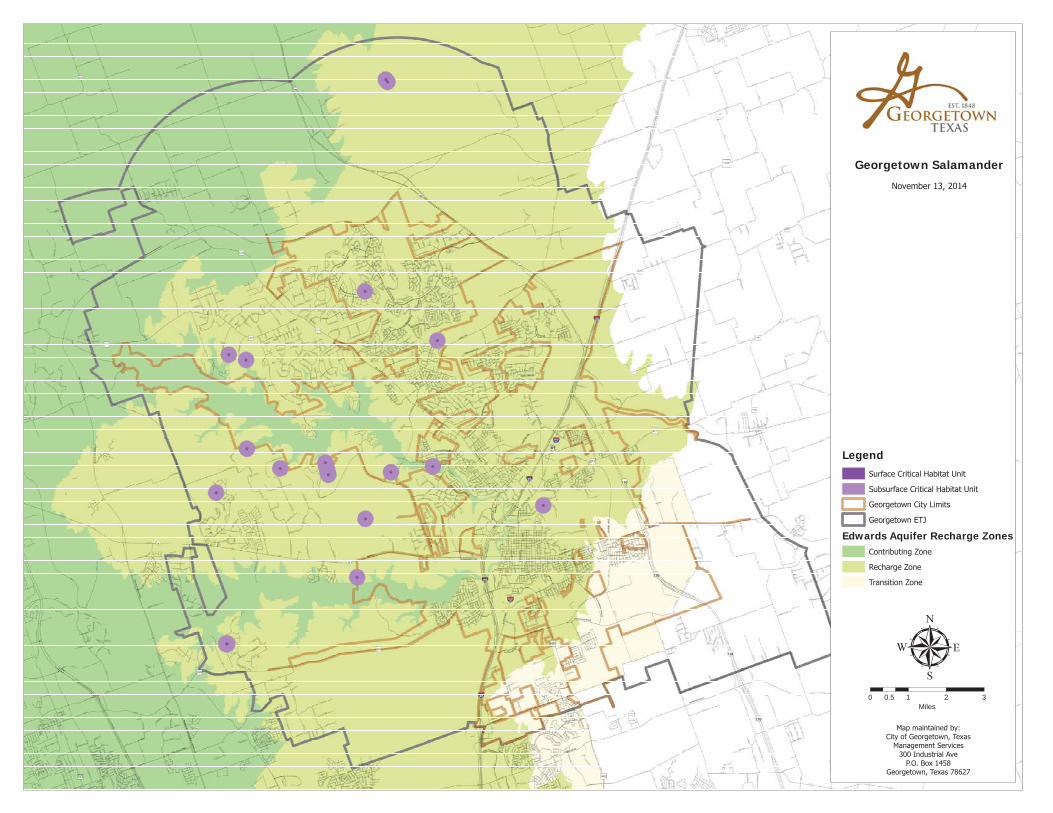
Georgetown Salamander
μ0 1 2 30.5
Miles
LegendSurface Critical Habitat Unit
Subsurface Critical Habitat Unit
Georgetown City Limits
Georgetown ETJ
Edwards Aquifer Recharge ZonesContributing Zone
Recharge Zone
Transition Zone
November 13, 2014
Map maintained by:City of Georgetown, Texas
Management Services300 Industrial Ave
P.O. Box 1458Georgetown, Texas 78627


Water Quality Acknowledgement Form Page 1 of 2 Revised: March 1, 2015
CITY OF GEORGETOWN
PLANNING DEPARTMENT EDWARDS AQUIFER RECHARGE ZONE
WATER QUALITY ACKNOWLEDGEMENT FORM
THE CITY’S WATER QUALITY REGULATIONS FOR PROPERTY OVER THE EARZ
A signed and notarized copy of this form is required to be submitted with a required development application [Plat (Preliminary, Final, Minor, Amending and Replat); Subdivision Construction Plan, Site Development Plan; or Stormwater Permit] for all Regulated Activity for property located over the Edwards Aquifer Recharge Zone (“EARZ”) within the City Limits and its Extraterritorial Jurisdiction (“ETJ”). No application will be accepted without completing this form.
PROPERTY INFORMATION
Property Address:
Legal Description:
City/ETJ: Acres:
PROJECT INFORMATION
Name of Project:
Application Type:
Proposed Use: No. of Lots:
PROPERTY OWNER/REPRESENTATIVE INFORMATION
Business Name:
Point of Contact:
Address:
Contact Information: Phone: Email:
PROPERTY OWNER’S CONSENT
I, , swear and affirm that I am the owner of property at , as shown in the records of Williamson County, Texas, which is the subject of this form.
I, , the owner of the property subject to this form, authorize to submit this acknowledgement form and serve as my representative for this request.
Property Owner’s Signature: Date:

Water Quality Acknowledgement Form Page 2 of 2 Revised: March 1, 2015
AFFIDAVIT
My name is , and I am the owner or authorized representative of the property that is subject of this request to the City of Georgetown, Texas. I hereby certify under penalty of perjury the following:
1. The Regulated Activity, as proposed, is in compliance with the City’s Water Quality Best Management Practices (UDC Section 11.07.004); and
2. The subject property has an Occupied Site, or is located within 984 feet of an Occupied Site; and The Regulated Activity, as submitted, complies with the Federal standards in UDC Appendix A; or
A variance request has been submitted to the Williamson County Conservation Foundation Adaptive Management Working Group on the Federal standards outlined in UDC Appendix A; or
The owner of property will coordinate directly with the USFWS; or
3. The subject property has a Stream and/or Spring located more than 984 feet from an Occupied Site, and the Regulated Activity, as submitted, complies with UDC Section 11.07. In addition,
A Geologic Assessment was completed in accordance with UDC Section 11.07 and is made part of this development application (attached); or
The project, as proposed: Does not meet the definition of a Regulated Activity; or Meets all of the criteria below: Proposed development is Single-Family Residential or Two-Family Residential; and Subject property is located on an individual lot that is less than 5 acres; and Subdivision (to include replat) is 5 lots or less, and no more than 5 gross acres; and Subject property is located within a drainage area that is less than 64 acres.
NOTE: A letter signed by an Engineer certifying the drainage area and identifying any springs on the subject property must be submitted with the required application.
Thus no Geologic Assessment is required with this development application. Signed this day of , 20
Signature: STATE OF TEXAS { KNOW ALL MEN BY THESE PRESENTS COUNTY OF WILLIAMSON { Sworn and subscribed before me by on this day of in the year , to certify which witness my hand and seal of office. Notary Public in and for the State of Texas My Commission expires on:

Water Quality Acknowledgement Form Page 1 of 2 Issued: March 11, 2015
CITY OF GEORGETOWN
INSPECTION SERVICES DEPARTMENT EDWARDS AQUIFER RECHARGE ZONE
WATER QUALITY ACKNOWLEDGEMENT FORM
THE CITY’S WATER QUALITY REGULATIONS FOR PROPERTY OVER THE EARZ
This form does not apply to new Single-Family Residential (“SFR”) and Two-Family Residential (“TFR”) in a platted subdivision and where all public improvements were completed and accepted by the applicable jurisdiction, provided the proposed development, as submitted, is in accordance with the approved Water Pollution Abatement Plan of the Subdivision.
A signed and notarized copy of this form is required to be submitted with an application for Building Permit for all new SFR and TFR on property located over the Edwards Aquifer Recharge Zone (“EARZ”) within the City Limits and its Extraterritorial Jurisdiction (“ETJ”), except as noted above.
PROPERTY INFORMATION
Property Address:
Legal Description:
City/ETJ: Acres:
PROJECT INFORMATION
Name of Project:
Proposed Use:
PROPERTY OWNER/REPRESENTATIVE INFORMATION
Business Name:
Point of Contact:
Address:
Contact Information: Phone: Email:
PROPERTY OWNER’S CONSENT
I, , swear and affirm that I am the owner of property at , as shown in the records of Williamson County, Texas, which is the subject of this form.
I, , the owner of the property subject to this form, authorize to submit this acknowledgement form and serve as my representative for this request.
Property Owner’s Signature: Date:

Water Quality Acknowledgement Form Page 2 of 2 Revised: March 1, 2015
AFFIDAVIT
My name is , and I am the owner or authorized representative of the property that is subject of this request to the City of Georgetown, Texas. I hereby certify under penalty of perjury the following:
1. The Regulated Activity, as proposed, is in compliance with the City’s Water Quality Best Management Practices (UDC Section 11.07.004); and
2. The subject property has an Occupied Site, or is located within 984 feet of an Occupied Site; and The Regulated Activity, as submitted, complies with the Federal standards in UDC Appendix A; or
A variance request has been submitted to the Williamson County Conservation Foundation Adaptive Management Working Group on the Federal standards outlined in UDC Appendix A; or
The owner of property will coordinate directly with the USFWS; or
3. The subject property has a Stream and/or Spring located more than 984 feet from an Occupied Site, and the Regulated Activity, as submitted, complies with UDC Section 11.07. In addition,
A Geologic Assessment was completed in accordance with UDC Section 11.07 and is made part of this development application (attached); or
The project, as proposed: Does not meet the definition of a Regulated Activity; or Meets all of the criteria below: Proposed development is Single-Family Residential or Two-Family Residential; and Subject property is located on an individual lot that is less than 5 acres; and Subdivision (to include replat) is 5 lots or less, and no more than 5 gross acres; and Subject property is located within a drainage area that is less than 64 acres.
NOTE: A letter signed by an Engineer certifying the drainage area and identifying any springs on the subject property must be submitted with the required application.
Thus no Geologic Assessment is required with this development application. Signed this day of , 20
Signature: STATE OF TEXAS { KNOW ALL MEN BY THESE PRESENTS COUNTY OF WILLIAMSON { Sworn and subscribed before me by on this day of in the year , to certify which witness my hand and seal of office. Notary Public in and for the State of Texas My Commission expires on:

CB 117—EXHIBIT D
Stakeholder wishes to develop property
Is the property over the EARZ?
Not subject to the Water Quality
Regula ons. Project must comply
with other applicable development
regula ons and requirements.
Subject to Water Quality Regula ons
(UDC Sec on 11.07)
Is the proposed project (must meet all):
1) A SFR or TFR development?
2) On an individual lot that is less than 5 acres?
3) If new subdivision (includes replat), subdivision is 5
lots or less, and no more than 5 gross acres?
4) Located within a drainage area less than 64 acres?
No GA required. However, property owner, or
representa ve, must submit the following with
the first development applica on*:
1) Signed/notarized Acknowledgement Form
2) Le er from an Engineer:
A) Iden fying springs on the property, if
any. In the event that springs exist,
Engineer must iden fy applicable buffer
zones on the site/plot plan.
B) Cer fying the drainage basin where the
property is located.
GA and signed/notarized
Acknowledgement Form required (to
be submi ed with the first
development applica on)*
LEGEND
AMWG ‐ Adap ve Management Working Group
CC ‐ (Georgetown) City Council
COG ‐ City of Georgetown
EARZ ‐ Edwards Aquifer Recharge Zone
GA ‐ Geologic Assessment
SFR ‐ Single‐Family Residen al
TFR ‐ Two‐Family Residen al
TSS ‐ Total Suspended Solids
USFWS ‐ US Fish and Wildlife Service
Does the GA iden fy springs and/or streams? (must
also be iden fied (with buffers and zones) on the Plat,
Site Development Plan, etc.)
Proposed project must comply with
other applicable Water Quality
standards and requirements
Is it an occupied (named) site (EXHIBIT A)? Subject to disturbance zone requirements per
federal standards (UDC Appendix A)
Project designed in
accordance with adopted
federal standards
Coordinate with USFWS
on alternate/op ons
Submit a request for a
variance to AMWG
AMWG recommenda on
on variance to USFWS
Project designed in
accordance with Water
Quality Regula ons
Project designed in
accordance with adopted
federal standards
Coordinate with USFWS
on alternate/op ons
YES
YES
YES
YES
YES
YES
NO
NO
NO
NO
NO
YES
NO
NO
*Subsequent applica ons must be consistent with first development applica on, as approved. Any devia ons will result
in the submi al of a new Water Quality Acknowledgement Form and GA, when applicable, prior to final approval of the
applica on, or documenta on of non‐compliance by City staff in the file.
Submit request for a
variance to P&Z
P&Z considers variance
request
Project designed per
Water Quality
Regula ons
Request for Appeal to
CC
YES
NO
NOTE: Newly established water
quality measures must comply with
85% TSS removal.
Proceed to
approval of
development
applica on
Issued: March 11, 2015
Proceed to
approval of
development
applica on
Subject to buffer zone requirements
(UDC Sec on 11.07)