review of the deschutes basin groundwater …
TRANSCRIPT

REVIEW OF THE DESCHUTES BASIN GROUNDWATER MITIGATION PROGRAM
www.oregon.gov/OWRD
5 YEAR REVIEW STATE OF OREGON
2021 - DRAFT
REVIEW OF THE DESCHUTES
BASIN GROUNDWATER
MITIGATION PROGRAM

REVIEW OF THE DESCHUTES BASIN GROUNDWATER MITIGATION PROGRAM
www.oregon.gov/OWRD i
2021 - DRAFT
5 YEAR REVIEW
Dwight French, Water Right Services Division Administrator
Sarah Henderson, Flow Restoration Program Coordinator
Lisa Jaramillo, Transfer and Conservation Manager
Jonathan La Marche, Hydrologist
Kyle Gorman, South Central Region Manager
Mellony Hoskinson, Water Availability Analyst
Jordan Beamer, Water Availability Program Coordinator
STATE OF OREGON
REVIEW OF THE DESCHUTES
BASIN GROUNDWATER
MITIGATION PROGRAM

REVIEW OF THE DESCHUTES BASIN GROUNDWATER MITIGATION PROGRAM
www.oregon.gov/OWRD ii
Table of Contents I. Executive Summary .................................................................................................................. 1
II. Introduction ............................................................................................................................ 4
III. Reporting Requirements ......................................................................................................... 5
A. ORS 540.155 Legislative Review ....................................................................................................... 5
B. OAR 690-505 Administrative Review ................................................................................................ 5
IV. Stakeholder Engagement and Process for Developing the Report ......................................... 6
V. Structure of the Mitigation Program ........................................................................................7
VI. Allocation Cap Status .............................................................................................................. 8
VII. Program Impacts on Other Water Users of the Deschutes River Basin ................................. 11
A. Overview of the Basin and Water Rights ........................................................................................ 11
B. Injury to Other Water Rights ........................................................................................................... 11
C. Property and Water Right Value ..................................................................................................... 12
D. Cities and Other Water Providers ................................................................................................... 13
E. Irrigation Districts............................................................................................................................ 14
A. Deschutes River Scenic Waterway, Instream Flows, and Fish and Wildlife Habitat ....................... 16
VIII. Potential Timing of Mitigation ........................................................................................ 18
IX. Identification of Zones of Impact ........................................................................................... 19
A. General Zone of Impact .................................................................................................................. 19
B. Local Zones of Impact ..................................................................................................................... 20
C. Zone of Impact Identification for Groundwater Permit Applications ............................................. 29
D. Zone of Impact Identification for Mitigation Projects .................................................................... 31
X. Review of Impacts on the Headwaters of the Metolius River and Other Key Reaches of the
Metolius River System .................................................................................................................. 33
XI. Potential Timing of Federal, State and Local Storage Improvements .................................. 33
XII. Identification of Regulatory and Statutory Changes that may Improve the Program in Order
to Address and Mitigate Injury to Existing Water Rights and Spring Systems and to Offset
Measurable Reductions of Scenic Waterway Flows ..................................................................... 34
A. Impacts to Local Springs.................................................................................................................. 34
B. Pre-Mitigation Program Permits (7J permits): ................................................................................ 35
C. Require Mitigation for Undeveloped Permits when Extension of Time is Requested: .................. 36
XIII. Mitigation and Streamflow Monitoring ......................................................................... 37
XIV. Other Issues Identified by Stakeholders ........................................................................ 39
A. Need for more permanent mitigation, monitoring and compliance: ............................................. 39
B. Consumptive Use: ........................................................................................................................... 44
C. Permanent mitigation credits used temporarily: ........................................................................... 45
D. Consideration of the Impacts of Exempt Wells: ............................................................................. 45

REVIEW OF THE DESCHUTES BASIN GROUNDWATER MITIGATION PROGRAM
www.oregon.gov/OWRD iii
E. Use of Storage Releases and Allocations of Conserved Water as Mitigation Projects: .................. 45
Figure 1: Deschutes Basin Groundwater Study Area .................................................................................. 3
Figure 2: Potential Distribution of Mitigation Under the 200 CFS Allocation Cap as of the End of 2019 . 9
Figure 3: Types of Uses for Permits Issued that Required Mitigation & Number of Applications
Submitted by Type of Use .......................................................................................................................... 10
Figure 4: Types of Uses for Applications Pending at the End of 2019 Requiring Mitigation & Number of
Pending Applications by Type of Use ........................................................................................................ 10
Figure 5: Irrigated Acres with Water Rights Converted to Instream Use for Mitigation - Irrigation
District Acres in Comparison to All Acres .................................................................................................. 13
Figure 6 -Incremental Development Permits at End of 2019: Volume Approved, Required Mitigation,
Mitigation Provided, and Actual Volume Used ......................................................................................... 14
Figure 7: Permanent (Cumulative) Mitigation in Acre-Feet Provided by Irrigation District (ID) Versus All
Permanent (Cumulative) Mitigation .......................................................................................................... 15
Figure 8: Temporary Annual Mitigation in Acre-Feet Provided by Irrigation District (ID) Versus All
Temporary Annual Mitigation ................................................................................................................... 15
Figure 9: Quantity in CFS of Permanent (Cumulative) and Temporary (Annual) Water Protected
Instream Resulting from the Mitigation Program through 2019 .............................................................. 17
Figure 10: General Zone of Impact Map .................................................................................................... 20
Figure 11: Middle Deschutes Zone of Impact Map ................................................................................... 22
Figure 12: Whychus Creek Zone of Impact Map ....................................................................................... 23
Figure 13: Crooked River Zone of Impact Map .......................................................................................... 24
Figure 14: Little Deschutes River Zone of Impact Map ............................................................................. 25
Figure 15: Upper Deschutes River Zone of Impact Map ........................................................................... 27
Figure 16: Metolius River Zone of Impact Map ......................................................................................... 28
Figure 17: Cone of Depression ................................................................................................................... 30
Figure 18: Number of 7J Pre-Mitigation Program Permits & Status ........................................................ 36
Figure 19: Total CFS of Each Status of 7J Pre-Mitigation Program Permits .............................................. 36
Figure 20: Annual CFS Change in % of time Instream at Identified Gages ............................................... 39
Figure 21: Delinquent Number of Permits by Year ................................................................................... 40
Figure 22: Supply and Use of Temporary Mitigation ................................................................................ 42
Figure 23: Amount of Mitigation Available by Year & by Type ................................................................ 43
Figure 24: Supply and Use of Permanent Mitigation ................................................................................ 43
Figure 25: Mitigation Credits Available by Zone of Impact ...................................................................... 44
Photo 1: Deschutes River below Bend in 2002 (Summer) .......................................................................... 16
Central Oregon Cities Organization (Attachment 1) ................................................................................. 47
Oregon Department of Environmental Quality (DEQ) (Attachment 2) .................................................... 50
John Short, Bend, Oregon (Attachment 3) ................................................................................................ 52
Oregon Department of Fish and Wildlife (ODFW) (Attachment 4) .......................................................... 53
Oregon Farm Bureau, Deschutes County Farm Bureau, Crook-Wheeler County Farm Bureau, Jefferson
County Farm Bureau (Attachment 5) ........................................................................................................ 59

REVIEW OF THE DESCHUTES BASIN GROUNDWATER MITIGATION PROGRAM
www.oregon.gov/OWRD iv
Clyde Snow LLC on behalf of Shanda Asset Management, LLC (Attachment 6) ...................................... 62
Confederated Tribes of Warm Springs (Attachment 7) ............................................................................ 64
WaterWatch of Oregon (Attachment 8) .................................................................................................... 65
Nunzie Gould, Bend, Oregon (Attachment 9) ........................................................................................... 69

REVIEW OF THE DESCHUTES BASIN GROUNDWATER MITIGATION PROGRAM
www.oregon.gov/OWRD 1
I. Executive Summary Background: Surface water flows in the Deschutes River and many of its tributaries are protected with
scenic waterway designations and/or instream water rights. In addition, there are hundreds of existing
surface water diversions for various uses, including irrigation and municipal use. In the 1990’s, a
groundwater study completed by U.S. Geological Survey, in cooperation with the Oregon Water
Resources Department (OWRD) and other partners, identified significant hydraulic connection between
groundwater and surface water within the Deschutes Groundwater Study Area (DGWSA). This
connection means that groundwater uses within the DGWSA impact streamflows and existing surface
water rights at short timescales.
Deschutes Mitigation Program: The Deschutes Groundwater Mitigation Program (Mitigation Program)
was established to provide a set of tools that applicants for new groundwater rights within the DGWSA
can use to mitigate for their impacts on surface water flows in order to obtain new groundwater
permits. This program allows for the development of new groundwater uses that would likely not
otherwise be allowed by requiring the purchase of mitigation credits or implementation of a mitigation
project. The Mitigation Program is authorized under Oregon Revised Statutes (ORS) 537.746 and 2005
Oregon Laws Chapter 669, as amended by 2011 Oregon Laws Chapter 694. The key goals of the
Groundwater Mitigation Program are to:
• Maintain flows for State Scenic Waterways and senior water rights, including instream water rights;
• Facilitate restoration of flows in the middle reach of the Deschutes River and related tributaries; and
• Sustain existing water uses and accommodate growth through new groundwater development.
Report to the Legislature: ORS 540.155 directs OWRD to report to the Legislative Assembly every five
years on the outcomes of the Mitigation Program. To improve reporting efficiency, OWRD has combined
the Oregon Administrative Rules (OAR) 690-505 report and the ORS 540.155 legislative report into one
report for the years 2015-2019.
In developing this report, OWRD is required to consider:
• Program impacts on other water users of the Deschutes River Basin;
• Potential timing of mitigation;
• Identification of zones of impact;
• Review of impacts on the headwaters of the Metolius River and other key reaches of the Metolius River system;
• Potential timing of federal, state and local storage improvements
• Other issues raised by stakeholders;
• Allocation cap status and whether the 200 CFS restriction should be modified;
• Mitigation activity;
• Identification of regulatory and statutory changes that may improve the Mitigation Program in order to address and mitigate injury to existing water rights and spring systems and to offset measurable reductions of scenic waterway flows;
• Zones of impact;
• Streamflow monitoring; and
• Effectiveness of mitigation projects and mitigation credits.
REVIEW OF THE DESCHUTES BASIN GROUNDWATER MITIGATION PROGRAM
www.oregon.gov/OWRD 2
Feedback from Stakeholders: To evaluate the Mitigation Program and develop the report, OWRD
solicited feedback on the Mitigation Program from over sixty Deschutes Basin stakeholders. The first
solicitation was sent through email on July 16, 2020. All initial feedback received in response to this
solicitation is included as Attachments 1-9 of this report.
The feedback received and concerns raised about the Mitigation Program related to the following
topics:
• The allocation cap
• Zonal mitigation and impacts
• Water accounting and impacts of climate change
• Impacts to springs
• Impacts during the non-irrigation season (release of stored water instream)
• Permits issued prior to adoption of the mitigation rules
• Exempt wells
Conclusion and Next Steps: Generally, the Mitigation Program has worked well and met the key goals of
the program. Through mitigation, the scenic waterway and instream water right flows have been
maintained and, in some areas, have been improved. The benefits of the program are significant in
some key areas where chronic low flows historically occurred, such as in the Deschutes River below
Bend, Crooked River below Smith Rock, and Whychus Creek below the Three Sisters Irrigation District
diversion.
OWRD continues to explore possible improvements to the Mitigation Program with the Oregon
Department of Fish and Wildlife (ODFW) and the Oregon Department of Environmental Quality (DEQ),
and with stakeholders. As discussed in the report, improvements can be made to the program. Broadly
speaking, some specific actions to improve the Mitigation Program include:
• OWRD should partner with ODFW and DEQ to jointly secure funding for a study aimed at identifying impacts to springs and spring complexes located within the DGWSA and to better understand the sources of those impacts, including the degree to which the Mitigation Program may contribute to the impacts.
• OWRD should explore the feasibility of making changes to the administrative rules to require holders of existing groundwater permits that were issued after July 19, 1995, but before adoption of the Mitigation Program, to provide mitigation when seeking an extension of time on undeveloped portions of their permit(s).
OWRD staff intend to continue conversations with ODFW, DEQ, Tribes, and stakeholders on issues
outlined above as well as other issues raised in the report as part of this evaluation to identify
opportunities for improving the Mitigation Program.

REVIEW OF THE DESCHUTES BASIN GROUNDWATER MITIGATION PROGRAM
www.oregon.gov/OWRD 3
Figure 1: Deschutes Basin Groundwater Study Area

REVIEW OF THE DESCHUTES BASIN GROUNDWATER MITIGATION PROGRAM
www.oregon.gov/OWRD 4
II. Introduction A groundwater study of the Deschutes Basin above Lake Billy Chinook was conducted in the late 1990’s
by the U.S. Geological Survey (USGS) in cooperation with the Oregon Water Resources Department
(OWRD) and Deschutes Basin partners. The groundwater study concluded that there is significant
hydraulic connection between groundwater and surface water in the area now referred to as the
Deschutes Groundwater Study Area (DGWSA) (Figure 1). This means that groundwater withdrawals
within this area affect surface water flows in the Deschutes River and its tributaries within short
timescales, and, as a result, OWRD must manage groundwater and surface water together.
Flows in the Deschutes River and many of its tributaries are somewhat protected by instream water
rights; however, flows set by instream water rights are not always met due to the junior priority dates of
most instream rights relative to out of stream water rights.
The Deschutes River is also a designated State Scenic Waterway. Consistent with the Oregon Revised
Statute (ORS) 390.835 of the State Scenic Waterway Act new groundwater use permits located within or
above a state designated scenic waterway can be issued only when they do not individually or
cumulatively measurably reduce scenic waterway flows or when the effects are mitigated. Measurable
reduction is either one percent of the average daily flows or one cubic foot per second (CFS), whichever
is less. For the Deschutes River, the amount of measurable reduction allowed is one (1.0) CFS. The
groundwater permits issued above the scenic waterway have met the threshold for a measurable
reduction.
Since flows for instream water rights and scenic waterways are not always met and additional
groundwater use would further reduce scenic waterway flows, OWRD may not approve new
groundwater permits in the DGWSA unless the impact of the new withdrawal is mitigated with a similar
amount of water being put instream.
The Deschutes Groundwater Mitigation Program (Mitigation Program) provides a set of tools that
applicants for new groundwater permits within the DGWSA can use to establish mitigation and, thereby,
obtain new permits from OWRD. This program is implemented under Oregon Administrative Rules
(OAR) Chapter 690, Divisions 505, 521, and 522. The original rules were adopted in 2002. For purposes
of to the Mitigation Program, Division 505 defines “mitigation” as “a means to moderate the impacts to
surface water flows from a groundwater appropriation by obtaining mitigation credits or by providing
for implementation of a mitigation project that results in mitigation water.”
In 2005, Oregon Laws Chapter 669 affirmed that the primary administrative rules for the Mitigation
Program (Divisions 505 and 521) satisfy the requirements relating to mitigation under the Scenic
Waterway Act (ORS 390.805 to 390.925), Instream Water Right Act (ORS 537.332 to 537.360), and the
Groundwater statutes (ORS 537.505 to 537.795), and authorized the program through January 2, 2014.
In 2011, Oregon Laws Chapter 694 extended the program’s sunset to January 2, 2029. ORS 540.155
requires reporting to the Legislative Assembly every five years on the outcomes of the Mitigation
Program.
As discussed later in this report, the Mitigation Program has been successful in meeting the key goals of
the program. Through mitigation, scenic waterway and instream water right flows have been
maintained on a yearly basis and, in some chronic low-flow areas, have been improved. The benefits of
REVIEW OF THE DESCHUTES BASIN GROUNDWATER MITIGATION PROGRAM
www.oregon.gov/OWRD 5
the program have been significant in some areas, such as in the Deschutes River below Bend, Crooked
River below Smith Rock, and Whychus Creek below the Three Sisters Irrigation District diversion. As a
result of the program, approximately 56 CFS of instream flow has been permanently restored to the
Deschutes River and its tributaries.
The water management issues in the Deschutes Basin are complex – municipal, instream, irrigation, and
recreation interests all have a stake in successful outcomes. OWRD’s Mitigation Program is just one of
the many efforts in the basin to address water imbalances. As outlined in this report, there are a variety
of opportunities to improve the Mitigation Program. While OWRD intends to continue conversations
with stakeholders to explore these opportunities for improvement, it also recognizes that many of the
comments and concerns provided extend beyond the scope of what the Mitigation Program can
accomplish and may be best addressed through other venues and initiatives, such as the Deschutes
Basin Water Collaborative and efforts to develop and implement a basin-wide water management plan.
III. Reporting Requirements The Department is required to develop a report on the Deschutes Mitigation Program annually under
ORS 537.746 and OAR 690-505-0500(3) and to report to the Legislative Assembly every five years under
ORS 540.155. In addition, the Department’s OAR 690-505-0500(2) rules require reporting every five
years to the Commission. To improve reporting efficiency, the Department has combined the OAR 690-
505 Administrative and ORS 540.155 Legislative five-year reviews, resulting in a report on the years
2015-2019.
A. ORS 540.155 Legislative Review
ORS 540.155 directs OWRD to report to the Legislative Assembly every five years on outcomes of the
Mitigation Program for the DGWSA.
The statute requires that the report include a summary of:
• Program impacts on other water users in the Deschutes River Basin;
• Potential timing of mitigation;
• Identification of zones of impact;
• Review of impacts on the headwaters of the Metolius River and other key reaches of the Metolius River system;
• Potential timing of federal, state and local storage improvements;
• Identification of regulatory and statutory changes that may improve the Mitigation Program in order to address and mitigate injury to existing water rights and spring systems and to offset measurable reductions of scenic waterway flows; and
• Other issues identified by stakeholders.
B. OAR 690-505 Administrative Review
OAR 690-505-0500(2), requires a five-year evaluation of the Deschutes Basin Groundwater Mitigation
Rules and associated mitigation to determine whether the 200 CFS allocation cap restriction should be

REVIEW OF THE DESCHUTES BASIN GROUNDWATER MITIGATION PROGRAM
www.oregon.gov/OWRD 6
modified through subsequent public rulemaking. It also requires evaluation of the effectiveness of
mitigation projects and mitigation credits that involve time-limited instream transfers, instream leases
and allocations of conserved water from canal lining and piping projects, as well as the general zones of
impact identified by the Department.
The OAR 690-505 five-year review must address the following topics:
• Allocation cap status and whether the 200 CFS restriction should be modified;
• Mitigation activity;
• Zones of impact;
• Streamflow monitoring; and
• Effectiveness of mitigation projects and mitigation credits.
IV. Stakeholder Engagement and Process for Developing the Report
In development of this report, on July 16, 2020, OWRD solicited input from a variety of stakeholders via
email on the Mitigation Program. These stakeholders included over sixty different state, federal, and
county agencies, irrigation districts, watershed councils, cities, water companies, consultants,
restoration partners and many others. Feedback was received from:
• Central Oregon Cities Organization; (Attachment 1)
• Oregon Department of Environmental Quality (DEQ); (Attachment 2)
• John Short, Bend, Oregon; (Attachment 3)
• Oregon Department of Fish and Wildlife (ODFW); (Attachment 4)
• Oregon Farm Bureau; (Attachment 5)
• Deschutes County Farm Bureau; (Attachment 5)
• Crook-Wheeler County Farm Bureau; (Attachment 5)
• Jefferson County Farm Bureau; (Attachment 5)
• Clyde Snow LLC on behalf of Shanda Asset Management, LLC; (Attachment 6)
• WaterWatch of Oregon; (Attachment 8) and
• Nunzie Gould, Bend, Oregon; (Attachment 9).
In addition, OWRD solicited input from the Confederated Tribes of Warm Springs (CTWS). In response,
the CTWS provided feedback. (Attachment 7). The Tribal Council will be seeking a government-to-
government consultation with OWRD.
OWRD developed this report using the feedback provided by the CTWS and stakeholders listed above, as
well as technical and local staff input.
All initial feedback provided in response to this solicitation is included as Attachments 1-9 at the back of
this report.
Next Steps for Report – This draft report is currently being sent out to Tribal and Stakeholders for
solicitation of feedback on this report and will have a 30-day comment period. There will also be a
second opportunity to comment on the second draft of the report.

REVIEW OF THE DESCHUTES BASIN GROUNDWATER MITIGATION PROGRAM
www.oregon.gov/OWRD 7
V. Structure of the Mitigation Program The Deschutes Groundwater Mitigation Program provides a set of tools that groundwater permit
applicants can use to establish new groundwater uses within the DGWSA while mitigating impacts on
surface water. The key goals of the Mitigation Program are to:
• Maintain flows for State Scenic Waterways and senior water rights, including instream water rights;
• Facilitate restoration of flows in the middle reach of the Deschutes River and related tributaries; and
• Sustain existing water uses and accommodate growth through new groundwater development.
The amount of new groundwater use that can be approved under the Mitigation Program is currently
limited to a total of 200 CFS, often referred to as the allocation cap. Once the allocation cap limit is met,
no additional permits can be issued without the Water Resources Commission modifying its rules and
adjusting the cap.
Mitigation is provided through completion of a mitigation project. Generally, mitigation has been
established by the conversion of existing consumptive use surface water rights to instream non-
consumptive use. Mitigation established under the Mitigation Program is permanent or temporary in
nature; therefore, OWRD must maintain an accounting record of new groundwater permits and
associated mitigation with links between the groundwater permits and their source of mitigation.
Most mitigation for new groundwater use has come from the conversion of out-of-stream uses, such as
irrigation, to instream use through a temporary instream lease or permanent instream transfer.
Mitigation for a new groundwater permit must be provided for the life of that permit and subsequent
water right certificate.
Overall, for each year the Mitigation Program has been in place, there has been sufficient mitigation
water available to mitigate for groundwater permits issued under the program. However, in certain
areas, sufficient supplies of mitigation water may not always be available to satisfy the mitigation needs
of all pending groundwater use requests due to the location of the applications.
Stakeholder Comments: Feedback from Central Oregon Cities Organization expresses the importance of
OWRD not losing sight of the goals of the Mitigation Program when reviewing the program and
considering potential changes, and urges OWRD to be mindful of the fact that the program is to provide

REVIEW OF THE DESCHUTES BASIN GROUNDWATER MITIGATION PROGRAM
www.oregon.gov/OWRD 8
for mitigation of impacts to scenic waterway flows and senior water rights, while allowing additional
qualifying appropriations of groundwater.
OWRD Response: OWRD concurs with the importance of keeping the goals of the Mitigation Program a
primary focus. One way OWRD strives to achieve these goals is through implementation of its
administrative rules (OAR Chapter 690, Divisions 505, 521 and 522) which:
• Require mitigation for all new groundwater permits in the DGWSA;
• Identify tools for providing mitigation water through either a mitigation project or by obtaining mitigation credits from an established mitigation project;
• Establish a system of mitigation credits which may be used to mitigate for new groundwater permits;
• Provide the process to establish mitigation banks; and
• Provide for adaptive management through annual evaluations and review of the Mitigation Program every five years.
VI. Allocation Cap Status Since adoption of the Mitigation Program rules in September 2002 and through the end of 2019, OWRD
had issued 121 new groundwater permits with associated mitigation, totaling 154.41 CFS of water. In
addition to the 154.41 CFS allocated, there was 7.53 CFS in pending applications with approved final
orders (i.e., awaiting mitigation; permit not yet issued) and approximately 17.98 CFS associated with
additional pending applications. If all applications pending as of December 31, 2019, were to move
forward as proposed, there would be approximately 20.08 CFS left under the 200 CFS allocation cap (see
Figure 2).

REVIEW OF THE DESCHUTES BASIN GROUNDWATER MITIGATION PROGRAM
www.oregon.gov/OWRD 9
Figure 2: Potential Distribution of Mitigation Under the 200 CFS Allocation Cap as of the End of 2019
Figure 3 shows the different types of uses for approved groundwater permits that obtained mitigation
under the program; the majority being irrigation, quasi-municipal and municipal uses. This figure also
shows the number of applications that were submitted by type of use.
Permits Issued, 154.41 CFS
Pending Applications with Final Orders,
7.53 CFS
Pending Applications, 17.98 CFS
Not Allocated, 20.08 CFS

REVIEW OF THE DESCHUTES BASIN GROUNDWATER MITIGATION PROGRAM
www.oregon.gov/OWRD 10
Figure 3: Types of Uses for Permits Issued that Required Mitigation & Number of Applications Submitted by Type of Use
Figure 4 shows the different types of uses of pending groundwater applications requiring mitigation; the
majority being irrigation. This figure also shows the number of pending applications by type of use.
Figure 4: Types of Uses for Applications Pending at the End of 2019 Requiring Mitigation & Number of Pending Applications by Type of Use
Stakeholder Comments: ODFW, DEQ, WaterWatch of Oregon and an individual commenter (Nunzie
Gould), have suggested that the 200 CFS allocation cap should not be raised at this time. ODFW
89
21
9
9
8
8
65 2 2 2 Irrigation
Quasi-Municipal
Pond Maintenance
Nursery
Municipal
Storage
Commercial
Manufacturing
Group Domestic
Agriculture
Supplemental Irrigation
11
6
3
2
2
21 1
Irrigation
Nursery
Pond Maintenance
Fire Protection
Aesthetics
Commercial
Storage
Recreation

REVIEW OF THE DESCHUTES BASIN GROUNDWATER MITIGATION PROGRAM
www.oregon.gov/OWRD 11
identified that until such time as issues associated with groundwater impacts outside of the irrigation
season can be addressed, the cap should not be adjusted. WaterWatch of Oregon further suggested
that all issues should be resolved before consideration of raising the allocation cap. Central Oregon
Cities Organization has suggested that the allocation cap be discussed very soon.
OWRD Response: OWRD does not anticipate an immediate need to change the 200 CFS allocation cap;
however, OWRD would like to explore the issue of modification of the allocation cap in the next few
years. The allocation cap has been in place under the Mitigation Program for over 19 years. Assuming
all applications and final orders pending as of December 31, 2019, move forward as proposed, there will
still be approximately 20.08 CFS left under the 200 CFS allocation cap. Once the cap limit is met, no
additional permits can be issued without the Water Resources Commission modifying its rules and
adjusting the cap. OWRD would like to explore the issue of modification of the allocation cap in the next
few years.
VII. Program Impacts on Other Water Users of the Deschutes River Basin
A. Overview of the Basin and Water Rights
Much of the mainstem Deschutes River and its tributaries are protected by scenic waterway
designations and instream water rights. There are also hundreds of existing surface water rights on the
Deschutes River and its tributaries for out of stream uses, such as irrigation and municipal uses.
The Deschutes Basin contains numerous small agricultural communities as well as some of the fastest
growing cities in the state. While the economy in some areas has shifted toward service industries and
tourism, farming and ranching remain important. Land use in the Deschutes Basin is characterized by
numerous smaller, privately held parcels alongside larger areas owned and managed by federal, state
and tribal agencies.
The Basin’s economy relies heavily upon abundant, clean water. Surface water is fully appropriated
resulting in an increased reliance on groundwater as a source for future appropriation. Groundwater
users include municipalities, irrigation districts, commercial developments, industry, homeowners’
associations, other private water providers and landowners, and water right permit exempt users.
B. Injury to Other Water Rights OWRD does not have evidence or information suggesting that the mitigation program has resulted in
injury to surface water rights, as evaluated on an annual basis. Injury occurs when one or more existing
water rights, including instream water rights, are unable to use the quantity of water to which they are
legally entitled as a result of a change in use by another existing water right or a new use. The
Department cannot approve a mitigation project if it results in injury.
The Water Resources Commission’s rules governing mitigation in the DGWSA are intended to assure
that new groundwater appropriations do not result in a measurable reduction in scenic waterway flows
or injury to senior water rights, including instream water rights. OAR 690-505-0630 states that if a

REVIEW OF THE DESCHUTES BASIN GROUNDWATER MITIGATION PROGRAM
www.oregon.gov/OWRD 12
groundwater applicant satisfies the required mitigation obligations, OWRD may conclude that the
proposed use will not substantially interfere with surface water rights, including instream water rights.
C. Property and Water Right Value The Mitigation Program has created a potential market for some surface water rights, which may
increase the value of those rights – although the Department has not undertaken a formal study. No
formal analysis of the effect of the mitigation program on property values has been conducted or
commissioned by OWRD. Groundwater users needing to provide mitigation can either complete their
own mitigation project or obtain mitigation credits from a mitigation credit holder – an individual or
entity that has completed a mitigation project. Surface water rights have either been leased for
instream use through the Deschutes River Conservancy (DRC) Mitigation Bank, or transferred
permanently to instream use by individuals or entities needing mitigation for a new groundwater use or
wanting to establish mitigation credits that can later be sold to groundwater users needing mitigation.
Stakeholder Comments: Comments from Oregon Farm Bureau, Deschutes County Farm Bureau, Crook
and Wheeler County Farm Bureau, and Jefferson County Farm Bureau expressed concern related to
removal of water rights from farmland as the cities look to irrigation water as a source to provide
mitigation for municipal growth. They expressed concerns over reduced availability of irrigated farmland
along with reductions in the value of farmland.
Department Response: Figure 5 shows the annual trend of irrigated acreage converted (both temporarily
and permanently) to instream use for mitigation purposes from irrigation districts as compared to the
overall total number of irrigated acres with water rights converted to instream use for mitigation
purposes. However, it is also important to note that the majority of new groundwater rights have been
issued for irrigation purposes, allowing for new irrigated acres to be developed. Without the program
there would not be a venue to issue new groundwater rights in the Deschutes Groundwater Study Area.

REVIEW OF THE DESCHUTES BASIN GROUNDWATER MITIGATION PROGRAM
www.oregon.gov/OWRD 13
Figure 5: Irrigated Acres with Water Rights Converted to Instream Use for Mitigation - Irrigation District Acres in Comparison to All Acres
D. Cities and Other Water Providers
The cities of Bend, Prineville, Sisters, LaPine, Madras, Maupin, Redmond, Metolius, and Culver are within
the DGWSA. There are also several private quasi-municipal water providers, including Terrebonne
Domestic Water District, Avion Water Company, and Deschutes Valley Water District to name a few.
Aside from water savings realized through implementation of water conservation measures, the cities’
and water providers’ primary water source for new and continued development in the DGWSA is
groundwater. Without the Mitigation Program, municipal water providers (both public and private),
may not be able to meet growing water demands.
For the majority of the cities and private water providers issued groundwater permits under the
Mitigation Program, mitigation is being provided incrementally over a period of time as the water use is
developed. In general, to obtain a groundwater permit, mitigation must be in place before the permit
may be issued. However, municipal and quasi-municipal permit applicants may request to provide
mitigation incrementally under an incremental development plan, which is on file with OWRD and may
be modified upon request, provided they prepare and submit a Water Management and Conservation
Plan to OWRD within 2 to 3 years of permit issuance. They are allowed to match the amount of
mitigation provided to the rate of growth and need under the permit. Date ranges under plans currently
on file with OWRD range from the smallest at 5 years to the longest at 50 years. Most are in the range
of 20 to 30 years.
Figure 6 shows a comparison between the amount of water these water users are authorized to use at
full permit development, the amount of water they were able to use based on how much mitigation
they provided through 2019, and the amount of water they actually used during 2019. Overall,
0
500
1000
1500
2000
2500
3000
3500
4000
4500
2003 2004 2005 2006 2007 2008 2009 2010 2011 2012 2013 2014 2015 2016 2017 2018 2019
Nu
mb
er
of
Acr
es
Years
District Acres Total Acres

REVIEW OF THE DESCHUTES BASIN GROUNDWATER MITIGATION PROGRAM
www.oregon.gov/OWRD 14
throughout the years, the entities with incremental development plans have provided more mitigation
than was needed to mitigate for their actual water use. As of the end of 2019, there were 20 permits
with incremental development plans.
Figure 6 -Incremental Development Permits at End of 2019: Volume Approved, Required Mitigation, Mitigation Provided, and Actual Volume Used
E. Irrigation Districts A large percentage of the mitigation water established temporarily on an annual basis and permanently
in the DGWSA originates from water rights held by irrigation districts. Figures 7 and 8 show the amount
of mitigation (in acre-feet) originating from irrigation districts as compared to the total amount of
mitigation generated for use in the DGWSA.
29,865.6
2,144.0 2,689.3
13,601.4
6,133.4
975.5
0.0
5,000.0
10,000.0
15,000.0
20,000.0
25,000.0
30,000.0
35,000.0
VolumeApproved for
Permits
Actual VolumeUsed (Pumped)
MitigationProvided by end
of 2019
MitigationRequired for
PermitsApproved
Volume Allowedby Mitigation
Provided
MitigationRequired forActual Use
Acr
e-Fe
et

REVIEW OF THE DESCHUTES BASIN GROUNDWATER MITIGATION PROGRAM
www.oregon.gov/OWRD 15
Figure 7: Permanent (Cumulative) Mitigation in Acre-Feet Provided by Irrigation District (ID) Versus All Permanent (Cumulative) Mitigation
Figure 8: Temporary Annual Mitigation in Acre-Feet Provided by Irrigation District (ID) Versus All Temporary Annual Mitigation
0.0
1000.0
2000.0
3000.0
4000.0
5000.0
6000.0
7000.0
2003 2004 2005 2006 2007 2008 2009 2010 2011 2012 2013 2014 2015 2016 2017 2018 2019
Acr
e-F
ee
t o
f M
itig
atio
n W
ate
r/C
red
its
Total Permanent ID All Permament
0.0
500.0
1000.0
1500.0
2000.0
2500.0
3000.0
3500.0
4000.0
2003 2004 2005 2006 2007 2008 2009 2010 2011 2012 2013 2014 2015 2016 2017 2018 2019
Acr
e-F
ee
t o
f M
itig
atio
n W
ate
r/C
red
its
Total Temporary ID All Temporary

REVIEW OF THE DESCHUTES BASIN GROUNDWATER MITIGATION PROGRAM
www.oregon.gov/OWRD 16
A. Deschutes River Scenic Waterway, Instream Flows, and Fish and Wildlife Habitat
Most of the Deschutes River is a State Scenic Waterway. Under the State Scenic Waterway Act, the
highest and best uses of the waters of the Deschutes River are recreation, fish and wildlife uses. In
addition, the Deschutes River Basin above Pelton Round-Butte was once home to native runs of summer
steelhead, Chinook salmon, sockeye salmon, and Pacific lamprey. Efforts have been underway to
reestablish anadromous fish runs in the Upper Deschutes River sub-basin. Over the past decade, many
organizations and agencies have been working in the Deschutes River Basin to restore natural
streamflows and to improve water quality and aquatic habitat in the river and its main tributaries.
In 1998, when OWRD first initiated a process to address impacts of groundwater use on streamflows in
the Deschutes Basin, summer flows in the Deschutes River during the irrigation season below Bend were
often around 30 CFS. In the years leading up to the Mitigation Program, the irrigation districts, which
divert water at or above the City of Bend, agreed to leave a minimum of 30 CFS in the Deschutes River.
Photo 1 of the Deschutes River, below Bend, was taken in 2002 with flows at approximately 40 CFS.
The Mitigation Program rules were adopted by the Water Resource Commission in September 2002.
Currently, the minimum summer flows in the Deschutes River below Bend are around 130 CFS due, in
part, to the mitigation program as well as other restoration efforts undertaken by basin partners. Since
its inception, the Mitigation Program has helped restore and maintain flows in the Deschutes River and
its tributaries. By the end of 2019, approximately 84 CFS was protected instream by permanent and
temporary mitigation projects in the Deschutes River and its tributaries. Of that 84 CFS, approximately
Photo 1: Deschutes River below Bend in 2002 (Summer)

REVIEW OF THE DESCHUTES BASIN GROUNDWATER MITIGATION PROGRAM
www.oregon.gov/OWRD 17
56 CFS was established through permanent mitigation projects (instream transfers) and the rest were
temporary mitigation projects (instream leases) (Figure 9).
Figure 9: Quantity in CFS of Permanent (Cumulative) and Temporary (Annual) Water Protected Instream Resulting from the Mitigation Program through 2019
The primary source of mitigation has been the conversion of surface water irrigation rights to instream
water rights, resulting in water being protected instream during the irrigation season. The beneficial
uses of these new instream water rights, in addition to mitigation, are recreation, fish and wildlife
habitat, and pollution abatement.
It is important to note that the Mitigation Program is not the only source of additional flows in the
Deschutes River and its tributaries. There are many different organizations and agencies that are
working to restore streamflows in the Deschutes Basin. A goal for flow restoration of the mainstem
Deschutes River is to reach 250 CFS in protected instream flows, which is the amount requested in a
protested instream water right application filed in 1996 by the Oregon Department of Fish and Wildlife.
Additional flows in the Deschutes River, especially below Bend, have created opportunities for
recreation where some activities were not previously possible during the summer months. Recreational
activities, such as river floating, are now improved in reaches of the river that did not previously have
sufficient streamflows to support these activities. Recreational fishing has also improved as a result of
the additional flows.
State Agency and Stakeholder Comments: While streamflows have improved during the summer months
from the conversion of surface water irrigation rights to instream water rights, ODFW has expressed
concern about the Mitigation Program’s impacts on fish and other aquatic organisms’ habitat during the
portions of the year outside of the summer months and irrigation season, specifically through reduced
streamflows. They have also identified that portions of the DGWSA are also home to the recently
Endangered Species Act (ESA) listed Oregon spotted frog. According to ODFW, improvements to winter
flows in the Upper Deschutes, below Wickiup Reservoir and on Crescent Creek, a tributary of the Little
Deschutes River, are essential to the survival of the Oregon spotted frog and freshwater spring habitats
0
10
20
30
40
50
60
70
80
90
2003 2004 2005 2006 2007 2008 2009 2010 2011 2012 2013 2014 2015 2016 2017 2018 2019
CFS
Years
Permanent CFS Temporary CFS Total CFS
REVIEW OF THE DESCHUTES BASIN GROUNDWATER MITIGATION PROGRAM
www.oregon.gov/OWRD 18
in the upper basin. Instream flows provided under the Mitigation Program generally originate from
seasonal uses, such as irrigation, and have instream periods between April 1 and October 31 which
match the season of the originating use. ODFW expressed concern that new groundwater uses
ultimately have a distributed impact (reduction) on streamflows over the entire year and that mitigation
water (instream transfers from irrigation) is only provided during a portion of the year.
DEQ and WaterWatch expressed similar concerns related to when mitigation water is protected
instream and when impacts are occurring. Impacts of additional groundwater use, especially for
municipal and quasi-municipal uses, are expected to be distributed throughout the year whereas
mitigation is mostly provided during the irrigation season.
OWRD Response: While new groundwater use may take anywhere from a few weeks to several decades
to fully affect surface water flows depending on proximity to surface water and hydrogeologic
conditions, the impact on surface water flows will eventually be fully realized as a decrease in
streamflow over the course of the year (see Potential Timing of Mitigation section below for further
details).
From the beginning of the Deschutes Mitigation Program, it was determined that the program should be structured in such a way so that it was a manageable system for OWRD to track and maintain. OWRD considered the goals of the Mitigation Program, the Deschutes Groundwater Mitigation Flow Model, and the base period flows (1996-1995) and created sub-zones and consumptive use coefficients to keep the Deschutes Mitigation Program manageable. Seasonal uses were allowed to generate credits that can then be purchased to mitigate for year-round uses. OWRD will need to work with ODFW, DEQ and stakeholders to address this challenging issue.
VIII. Potential Timing of Mitigation As structured, mitigation water/credits (instream transfers and leases) are generally targeted to
enhance streamflow and offset new groundwater use during the irrigation season, which is also the time
period in which many stream reaches throughout the basin suffer from low flows and water quality
issues that are detrimental to aquatic life. For example, streamflow for the Deschutes River below Bend
has seen an increase in median summer streamflow from historic levels of around 35 CFS (1971-2000) to
values of over 130 CFS in recent years resulting from, in part, instream transfers and leases associated
with the Mitigation Program. Presently, the summer streamflow below Bend is managed according to
instream water rights resulting from the Mitigation Program and flow restoration work by the Deschutes
River Conservancy in partnership with the irrigation districts of Central Oregon. In summary, mitigation
credits have primarily increased streamflow during the summer.
In contrast, the effects of new groundwater pumping results in decreases in groundwater discharge to
streams, generally spread over a longer time period than just the irrigation season. The full impact on
surface water may not be realized for several years (Gannett and others, 2001; Gannett and Lite, 2007;
Gannett and others, 2017). Given the need to simplify the Mitigation Program and create a structure for
management, additional groundwater pumping represented as mitigation debits is assumed to produce
a decrease in groundwater discharge to streams and streamflow within the determined zone of impact
in a manner that is uniformly distributed over the year. This takes into account the fact that pumping
impacts tend to be spread out over a longer period of time.

REVIEW OF THE DESCHUTES BASIN GROUNDWATER MITIGATION PROGRAM
www.oregon.gov/OWRD 19
As a result of the structure, mitigation debits are debited from streamflow uniformly over the course of
the year, whereas mitigation credits are added to streamflow during the period in which the water is put
instream. This means that seasonally credits and debits may not be equal, but that on an annual basis
the program balances the quantity of debits and credits in each mitigation zone. The end result is that
the mitigation program has resulted in increases in streamflow during the irrigation season; however,
outside of the irrigation season, when streamflows are not augmented by mitigation water, the
mitigation program will result in reduced streamflows just as if groundwater permits were issued
without a mitigation program.
Stakeholder Comments: As noted in the previous section, several stakeholders have expressed concerns
related to the timing of mitigation and impacts of new groundwater use on surface water flows.
OWRD Response: See discussion above and Department response in the prior section. OWRD will need
to work with ODFW, DEQ and stakeholders to address this challenging issue in the future.
IX. Identification of Zones of Impact Part of mitigating for a proposed groundwater permit necessitates determining where the mitigation
must be provided in order to protect scenic waterway flows and senior water rights downstream of the
proposed point(s) of appropriation (i.e., well locations). The Mitigation Program rules (OAR Chapter
690, Division 505) divide the required location of mitigation into two areas – (1) in a general zone of
impact, and (2) in a local zone of impact. Mitigation under the Mitigation Program is water that is legally
protected instream and benefits the zone of impact in which a groundwater permit applicant is required
to provide mitigation.
Groundwater users with permits issued under the mitigation program are required to provide mitigation
within the appropriate zone of impact in the DGWSA identified by OWRD.
Below is a description of the zones of impact and the way that OWRD determines which zone(s) of
impact will be affected by the proposed new use of groundwater.
A. General Zone of Impact For mitigation in the General Zone of Impact (see Figure 10), the concept is that proposed wells in the
general zone are developing water in the “regional aquifer” and their groundwater pumping impacts are
on the regional groundwater discharge area near the confluences of the Deschutes, Crooked and
Metolius Rivers. Within this confluence area, groundwater discharges to surface water mostly through
large, discrete spring complexes.
Groundwater applicants identified by OWRD as needing to provide mitigation in the General Zone are
required to provide mitigation that benefits streamflows in the lower reaches and confluence area of
the Deschutes, Metolius, and Crooked Rivers. Instream flows for mitigation must originate upstream
from the Madras Gage, located approximately at River Mile 100.1 on the mainstem Deschutes River.
The Madras Gage is located at the lower end of the spring system discharging into the mainstem

REVIEW OF THE DESCHUTES BASIN GROUNDWATER MITIGATION PROGRAM
www.oregon.gov/OWRD 20
Deschutes River. By providing mitigation upstream from this point, mitigation is targeted to offset any
reduction in spring discharge from groundwater pumping.
Figure 10: General Zone of Impact Map
B. Local Zones of Impact For proposed wells determined by OWRD to have a localized impact on surface water, mitigation must
be provided in a local zone of impact. The local zones of impact were identified and developed by
OWRD as part of implementation of the Mitigation Program beginning in 2002. The goal in developing
the local zones of impact was to target mitigation in the sub-basin and above (upstream of) stream
reaches where impacts on streamflows by groundwater pumping would occur and where instream flows
were not being met. Instream flows considered in the development of the zones of impact were flows
established by State Scenic Waterway designation, instream water right applications filed by a state
agency, including ODFW, and/or conversion of minimum perennial streamflows to instream water
rights.

REVIEW OF THE DESCHUTES BASIN GROUNDWATER MITIGATION PROGRAM
www.oregon.gov/OWRD 21
In development of the local zones of impact, consideration was given to:
• Locations where instream flows (instream water rights and/or scenic waterway flows) were not being met;
• Sub-basin boundaries as identified by surface water divides;
• General groundwater flow information and specific identification of where stream reaches receive large amounts of groundwater discharge.
The lower boundary (the point above which mitigation would need to be provided) for each zone of
impact was identified by either of two means:
1. The lower boundary of the zone being below the lowest groundwater discharge area, or 2. The lower boundary of the zone being a point within a groundwater discharge area where
instream flows are not met upstream from that point.
The local zones of impact identified by OWRD included Whychus Creek, Crooked River, Little Deschutes
River, and the Metolius River sub-basin areas. The local zones also include the stretches of the
Deschutes River above River Mile 125 (referred to as the Middle Deschutes) and above River Mile 185
(referred to as the Upper Deschutes).
A discussion of each local zone of impact is included below.
Middle Deschutes: The Middle Deschutes Zone of Impact (Figure 11) encompasses the area of the
Deschutes River and tributaries above River Mile 125, two miles upstream of the Whychus Creek
confluence. Groundwater permit applications found to have an impact on surface water flows in this
zone must provide mitigation that benefits instream flows within the Deschutes River and have instream
reaches beginning upstream of River Mile 125.
Instream flows in this section of the Deschutes River are established by State Scenic Waterway
designation and an instream water right application (IS-70695) filed by the Oregon Department of Fish
and Wildlife (ODFW). Scenic Waterway instream flows range from 250 CFS to 500 CFS. Proposed
instream flows associated with instream water right application IS-70695 are 250 CFS.
From approximately River Mile 138 downstream to River Mile 125, the river can gain over 170 CFS from
groundwater discharge. Downstream from River Mile 125, instream flows, scenic waterway and
instream water right applications are generally met. In contrast, instream flows are generally not met
between River Mile 125 and River Mile 138. River mile 125 was selected as the lower boundary of this
zone to target mitigation into this stretch of the Deschutes River, as a result mitigation projects are
required to establish instream flows within a reach of the Deschutes River that is vulnerable to
groundwater interference and where proposed instream flows are not satisfied. Mitigation projects
(instream transfers and instream leases) developed in the Middle Deschutes Zone have resulted in
instream flows that are protected in the Deschutes River in reaches that extend through River Mile 125
and downstream to Lake Billy Chinook (at approximately River Mile 120).

REVIEW OF THE DESCHUTES BASIN GROUNDWATER MITIGATION PROGRAM
www.oregon.gov/OWRD 22
Figure 11: Middle Deschutes Zone of Impact Map
Whychus Creek: The Whychus Creek Zone of Impact (Figure 12) encompasses the area of the Whychus
Creek sub-basin above River Mile 16 on Whychus Creek near Hinkle Butte. Groundwater permit
applications found to have an impact on surface water flows in this zone must provide mitigation that
benefits instream flows in Whychus Creek beginning upstream from River Mile 16. River Mile 16 is just
downstream of a set of springs on the east side of McKinney Butte and is downstream of where the
groundwater level become significantly deeper than surface water elevations of Whychus Creek,
implying surface water is disconnected from groundwater downstream of this point.

REVIEW OF THE DESCHUTES BASIN GROUNDWATER MITIGATION PROGRAM
www.oregon.gov/OWRD 23
Instream flows in this section of Whychus Creek were established under an instream water right
application (IS-70753) filed by ODFW and authorized under Instream Certificate 73223. Instream flows
range from 33 CFS to 50 CFS.
Instream flows upstream from River Mile 16 that continue downstream to the Alder Springs area are
generally not met. However, groundwater use in this zone does not likely interfere with surface water
flows in Whychus Creek between River Mile 16 and Alder Springs (River Mile 1.5) because groundwater
levels are generally below surface water elevations. Groundwater use outside of this zone can impact
flows in the groundwater discharge area at Alder Springs but flows in Whychus Creek in that area are
sufficient to meet instream needs.
By using River Mile 16 as the lower boundary of the Whychus Creek Zone of Impact, new instream flows
established by a mitigation project may be targeted to begin in or upstream of a section of Whychus
Creek that is vulnerable to groundwater interference and where instream flow requirements are not
being met. Mitigation projects (instream leases and instream transfers) that have been used to establish
mitigation in the Whychus Creek Zone of Impact result in instream flows that begin upstream from River
Mile 16 and, at a minimum, extend to the mouth of Whychus Creek, which includes the Alder Springs
area.
Figure 12: Whychus Creek Zone of Impact Map
REVIEW OF THE DESCHUTES BASIN GROUNDWATER MITIGATION PROGRAM
www.oregon.gov/OWRD 24
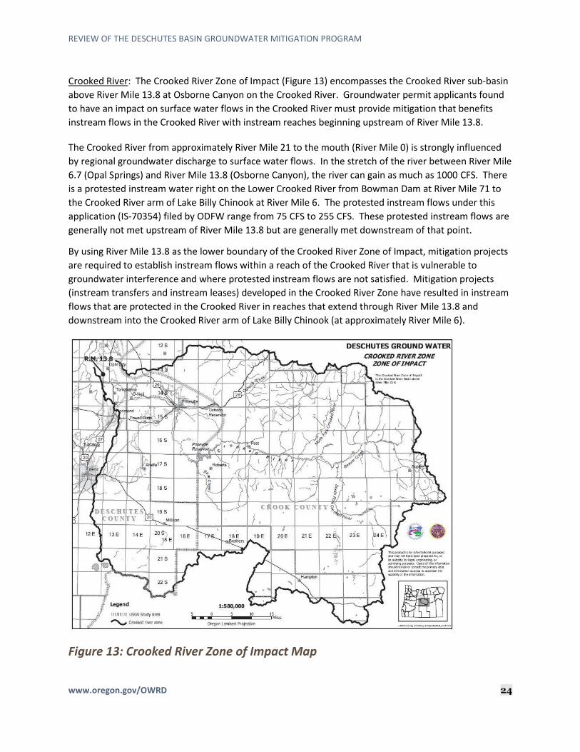
Crooked River: The Crooked River Zone of Impact (Figure 13) encompasses the Crooked River sub-basin
above River Mile 13.8 at Osborne Canyon on the Crooked River. Groundwater permit applicants found
to have an impact on surface water flows in the Crooked River must provide mitigation that benefits
instream flows in the Crooked River with instream reaches beginning upstream of River Mile 13.8.
The Crooked River from approximately River Mile 21 to the mouth (River Mile 0) is strongly influenced
by regional groundwater discharge to surface water flows. In the stretch of the river between River Mile
6.7 (Opal Springs) and River Mile 13.8 (Osborne Canyon), the river can gain as much as 1000 CFS. There
is a protested instream water right on the Lower Crooked River from Bowman Dam at River Mile 71 to
the Crooked River arm of Lake Billy Chinook at River Mile 6. The protested instream flows under this
application (IS-70354) filed by ODFW range from 75 CFS to 255 CFS. These protested instream flows are
generally not met upstream of River Mile 13.8 but are generally met downstream of that point.
By using River Mile 13.8 as the lower boundary of the Crooked River Zone of Impact, mitigation projects
are required to establish instream flows within a reach of the Crooked River that is vulnerable to
groundwater interference and where protested instream flows are not satisfied. Mitigation projects
(instream transfers and instream leases) developed in the Crooked River Zone have resulted in instream
flows that are protected in the Crooked River in reaches that extend through River Mile 13.8 and
downstream into the Crooked River arm of Lake Billy Chinook (at approximately River Mile 6).
Figure 13: Crooked River Zone of Impact Map

REVIEW OF THE DESCHUTES BASIN GROUNDWATER MITIGATION PROGRAM
www.oregon.gov/OWRD 25
Little Deschutes River: The Little Deschutes River Zone of Impact (Figure 14) encompasses the Little
Deschutes River sub-basin above the mouth of the Little Deschutes River. Groundwater permit
applicants found to impact surface water flows in this zone must provide mitigation that benefits
instream flows in the Little Deschutes River beginning upstream from the mouth of the river.
The mainstem of the Little Deschutes River and several of its tributaries in the upper reaches are
vulnerable to interference by groundwater use. The groundwater discharge reach on the Little
Deschutes River extends from the confluence with Crescent Creek at approximately River Mile 54
downstream to the mouth of the Little Deschutes River.
In this section of the Little Deschutes River, instream flows are established by an instream water right
application (IS-70757) filed by ODFW and authorized under Instream Certificate 73226. Instream flows
under Certificate 73226 range from 74.5 CFS to 240 CFS. These instream flows are not met in the Little
Deschutes River within the groundwater discharge area extending down to the mouth of the Little
Deschutes River.
By using the mouth of the Little Deschutes River as the lower boundary of the Little Deschutes Zone of
Impact, mitigation projects are required to establish instream flows within or above a reach of the Little
Deschutes River that is vulnerable to groundwater interference and where instream flows are not being
met. Mitigation projects (instream transfers and instream leases) developed in the Little Deschutes
Zone have resulted in instream flows that begin within or upstream of the groundwater discharge area
on the Little Deschutes River and extend at least to the mouth of the Little Deschutes River.
Figure 14: Little Deschutes River Zone of Impact Map

REVIEW OF THE DESCHUTES BASIN GROUNDWATER MITIGATION PROGRAM
www.oregon.gov/OWRD 26
Upper Deschutes: The Upper Deschutes Zone of Impact (Figure 15) encompasses the Deschutes River
sub-basin above River Mile 185. Groundwater permit applicants found to impact surface water flows in
this section of the Deschutes River must provide mitigation that benefits flows with instream reaches
beginning upstream from River Mile 185.
River Mile 185 is located on the mainstem Deschutes River a few miles downstream from its confluence
with Spring River near Sunriver. Flows in a significant portion of the Deschutes River above River Mile
185 are influenced by groundwater discharge and thus vulnerable to interference by new groundwater
use. River Mile 185 marks the approximate location where groundwater no longer appears to provide
significant contributions to surface water flows.
Instream flows upstream from River Mile 185 are established by scenic waterway designation and
conversions of minimum perennial streamflows to instream use. Scenic waterway instream flows range
from 400 CFS to 500 CFS. Instream flows based upon minimum perennial streamflows range from 300
CFS (upstream from the confluence with the Little Deschutes River) to 400 CFS (downstream, between
the confluence with the Little Deschutes River and the confluence with Spring River). These instream
flows are not met in the Deschutes River upstream of River Mile 185. Nor are they met downstream
from this point. However, as discussed above, the Deschutes River downstream from River Mile 185 is
not significantly influenced by groundwater discharge and groundwater use will not likely affect flows in
the Deschutes River downstream from River Mile 185 until the area of groundwater discharge in the
Middle Deschutes Zone of Impact.
By using River Mile 185 as the lower boundary of the Upper Deschutes Zone of Impact, new instream
flows established under a mitigation project may be targeted into a reach of the Deschutes River that is
both vulnerable to groundwater use and where instream flows are not being met.
Mitigation projects for this zone have originated in the Little Deschutes Zone of Impact. The mouth of
the Little Deschutes is located a few miles upstream from River Mile 185 on the mainstem Deschutes
River. Mitigation projects (instream leases and instream transfers) with instream flows protected in
instream reaches that extend past the mouth of the Little Deschutes and into the mainstem Deschutes
River protect instream flows on the mainstem Deschutes in the Upper Deschutes Zone of Impact,
downstream past River Mile 185 and down to Lake Billy Chinook at approximately River Mile 120.

REVIEW OF THE DESCHUTES BASIN GROUNDWATER MITIGATION PROGRAM
www.oregon.gov/OWRD 27
Figure 15: Upper Deschutes River Zone of Impact Map
Metolius River: The Metolius River Zone of Impact (Figure 16) encompasses the Metolius River sub-
basin upstream from River Mile 28 on the Metolius River. Groundwater permit applicants needing to
provide mitigation within this zone are required to provide mitigation that originates upstream from
River Mile 28 to target mitigation into the reach of the Metolius River that is affected by groundwater
use.
River Mile 28 is located at the confluence between the Metolius River and Jefferson Creek. This is the
lowest point in the Metolius River sub-basin where there is significant groundwater discharge to surface
water flows. Upstream from River Mile 28, streamflows in the Metolius River and many of its tributaries
are heavily influenced by groundwater discharge and are vulnerable to interference by groundwater
use. Downstream from River Mile 28, streamflows do not appear to be vulnerable to interference by
groundwater use.
The Metolius River is a designated State Scenic Waterway with instream flows ranging from 250 CFS to
350 CFS. The Metolius River and several of its tributaries also have instream water rights. Instream
flows, including scenic waterway flows, are met in the Metolius River sub-basin.

REVIEW OF THE DESCHUTES BASIN GROUNDWATER MITIGATION PROGRAM
www.oregon.gov/OWRD 28
One mitigation project has been established in this zone of impact for the one permit that has been
approved within this zone of impact. The mitigation project originated in the Metolius River zone of
impact. The instream reach protects flows in the South Fork of Lake Creek within the Metolius River
Zone of Impact. The mitigation project concluded that the closest likely downgradient groundwater
discharge area is the lower reaches of Lake Creek and tributary springs to the Metolius River.
Figure 16: Metolius River Zone of Impact Map

REVIEW OF THE DESCHUTES BASIN GROUNDWATER MITIGATION PROGRAM
www.oregon.gov/OWRD 29
C. Zone of Impact Identification for Groundwater Permit Applications
Stakeholder Comments: ODFW, DEQ, WaterWatch, and an individual commenter (Nunzie Gould) have all
commented on the process in which OWRD identifies the zone of impact for the mitigation program.
WaterWatch suggests that OWRD only requires mitigation in the “primary” zone of impact which raises
significate resource concerns and suggests that mitigation should be provided in all impacted zones.
ODFW stated that allowing mitigation for groundwater impacts to occur away from the point of impact
but within a larger “zone of impact” results in localized impacts to stream and the fish and wildlife they
support; particularly for the general zone of impact. ODFW stated that mitigation under the program
should directly offset the impact by being located upstream of the impacted reach consistent with the
program goals to provide for new groundwater uses while maintaining scenic waterway and instream
water right flows in the basin.
DEQ states that streamflows in the upper portions of the basin are more susceptible to diminishment
under the program. They purport that groundwater flow paths are shorter, which means that the
impacts of increased groundwater withdrawals on streamflow are likely to show up sooner. DEQ also
noted that mitigation credits may come from anywhere within the zone of mitigation, which means the
mitigation credits near the mouth can be used to offset a withdrawal near the headwaters and
recommends that mitigation projects be sited upgradient from the groundwater withdrawals. They
suggest groundwater withdrawals with direct, local impacts to streams, as determined by OWRD
groundwater section, should be mitigated by projects upstream of the diminished reach.
Nunzie Gould commented that it is important that the zone of impact should be used for place of
mitigation, not the zone of withdrawal and not a general zone of impact.
Department Response: From the beginning of the Mitigation Program, it was determined that the
program must be structured in such a way so that it was a manageable system for OWRD to track and
maintain over time. Part of that structure was the identification of different zones of impact within the
basin discussed in more detail above and below.
OWRD identifies a single zone of impact for each groundwater permit application. This is based upon
the understanding that the intent under the rules was to have 100% of the mitigation in the general
(regional) zone of impact or 100% in a localized zone of impact.
When OWRD was initially implementing the Mitigation Program, considerable thought was given to
using the best information available without making the review process overly complex. Using a
conceptual approach, OWRD reviews a proposed groundwater permit based on the well’s proximity to
groundwater discharge areas, its construction, hydraulic properties of the target aquifer, and general
groundwater flow direction to determine whether the proposed use will have a localized impact to
surface water. If the well will have a localized impact on surface water, OWRD finds that 100% of the
mitigation must occur in the local zone of impact. Put another way, if OWRD determines that a
proposed well will have a localized impact, OWRD does not further analyze the point of appropriation to
determine whether the proposed appropriation will also affect the aquifer in the general zone of

REVIEW OF THE DESCHUTES BASIN GROUNDWATER MITIGATION PROGRAM
www.oregon.gov/OWRD 30
impact. This approach allows for the use of locally applicable data and sound hydrologic principles. This
methodology has been used since the implementation of the Mitigation Program.
In general, when a well is pumped, the effects of groundwater pumping, being removal of water from
the aquifer, and lowering of the water level around the well, spreads in all directions forming a cone of
depression (see Figure 17). The effect spreads out radially from the well, with the magnitude and
geometry varying according to the local geology of the groundwater system. The cone of depression
continues to grow until sufficient groundwater flow is intercepted to supply the pumping. Once the
cone of depression stabilizes, the discharge of groundwater from the well must be offset by diminished
discharge of groundwater to springs, streams, and wetlands elsewhere, or by increased flow to the
aquifer system from other boundaries.
Figure 17: Cone of Depression
OWRD does not quantify and compare impacts to one zone or another in its zone of impact
determination when it assesses new groundwater applications in the DGWSA and does not use the
Deschutes groundwater flow model when it assesses applications. Instead, OWRD relies on the
conceptual approach initially described in this section and has consistently used this approach since
implementation of the Mitigation Program.
Single Zone of Impact: Using the conceptual approach, as described above, OWRD identifies a single
zone of impact for each groundwater permit application.
The goal of identifying a local zone of impact is to target mitigation in and upstream of areas impacted
by groundwater use. Mitigation for each local zone of impact is targeted to be either 1) Upstream from
the bottom of the lowest established groundwater discharge area in the zone, or 2) Upstream from the
point where instream requirements are not met within the lowest established groundwater discharge
area. OWRD is then able to require mitigation that originates upstream of affected areas that are
vulnerable to impacts by groundwater use and where additional streamflows are needed.

REVIEW OF THE DESCHUTES BASIN GROUNDWATER MITIGATION PROGRAM
www.oregon.gov/OWRD 31
D. Zone of Impact Identification for Mitigation Projects Mitigation for groundwater permit applications is provided by mitigation projects. A mitigation project
is a completed project that results in mitigation water. Mitigation water is water that can be legally
protected instream. One acre-foot of mitigation water is equal to one mitigation credit.
Groundwater permit applicants may either complete their own mitigation project or obtain mitigation
credits from an individual or entity, known as a mitigation credit holder, who has already completed a
mitigation project. The mitigation water/credits must be located in the same zone of impact as that
impacted by the groundwater permit application. When OWRD evaluates a mitigation project, it will
identify the zone of impact in which any mitigation water generated by the project may be used.
Mitigation projects establish mitigation water within at least one zone of impact and may establish
mitigation in more than one zone. For mitigation projects that establish mitigation in more than one
zone of impact, the instream reach extends through more than one zone of impact. For example, a
mitigation project that results in protected flows with an instream reach beginning in the Little
Deschutes River and extending into the mainstem Deschutes River downstream to Lake Billy Chinook,
would protect flows in the Little Deschutes Zone, the Upper Deschutes Zone, the Middle Deschutes Zone
and into the General Zone of Impact.
When determining the appropriate zone of impact for use of mitigation water from a mitigation project,
OWRD considers:
• The reach in which or point at which water may be protected instream; and
• Whether the project would provide a benefit to streamflow within the DGWSA and into the zone or zones of impact. For example, a project to establish mitigation in the Crooked River Zone of Impact that is located above Prineville Reservoir, on the Crooked River, outside of the DGWSA would have to demonstrate how water could be protected through the reservoir and down into the reach on the Crooked River affected by groundwater use.
Mitigation Projects are reviewed by OWRD under the Mitigation Program Rules (Division 505 and
Division 521) and they must also be reviewed under their originating process rules, currently being OAR
Chapter 690, Division 77 for establishment of Instream Water Rights. By rule, an instream water right
(established by instream transfer, instream lease, and allocation of conserved water) may be protected
within a reach from a point on the source stream (generally, the original point of diversion) to the
mouth of the source stream. Water may be protected past the mouth of the source stream only if the
quantity to be protected instream is a measurable portion of the receiving stream (OAR 690-077-
0015(8)).
Many mitigation projects originating on tributaries to the Deschutes River are not measurable portions
of the receiving stream, primarily the Deschutes River, and are only protected to the mouth of their
source stream. As instream quantities have increased (combination of restoration and mitigation flows),
newer mitigation projects may be protected past the mouth of the source stream. For example,
additional instream water rights established on Whychus Creek are now measurable and protectable
into the mainstem Deschutes River. However, projects originating in the Crooked River are not yet
measurable into the mainstem Deschutes River.

REVIEW OF THE DESCHUTES BASIN GROUNDWATER MITIGATION PROGRAM
www.oregon.gov/OWRD 32
Instream uses from Mitigation Projects that are protected instream in the mainstem Deschutes River
generally terminate at Lake Billy Chinook. In the Lake Billy Chinook area, there is a large area of
groundwater discharge to surface water flows. A portion of surface water diverted for out of stream
uses upstream from Lake Billy Chinook seeps into the groundwater system and returns to the surface
water system as subsurface return flows.
Under Division 77, OWRD is required to consider return flows as part of the establishment of the
instream use to prevent injury to other water rights. If return flows are identified, OWRD is required to
account for those return flows at an instream point downstream from the original diversion point or at
the point of diversion itself, if the return flows don’t occur at a definite point (See OAR 690-077-
0075(2)(b)(B) and (2)(c)(A)).
In general, subsurface return flows from uses occurring upstream from Lake Billy Chinook return to the
Deschutes River at or above the Madras Gage and become surface water flows that are then available to
downstream water rights. The Madras gage is located at approximately River Mile 100.1 and at the
bottom of the regional groundwater discharge area (spring system). The amount of water that may be
protected instream downstream from the Madras Gage is generally the consumptive portion of the
originating use. It is this consumptive portion that is also being used as mitigation of groundwater uses
under the Mitigation Program. To date, mitigation has been the conversion of an existing consumptive
surface water use to instream use in favor of a new consumptive groundwater use.
Given that instream flows in the Lower Deschutes River would be limited to the consumptive portion of
the originating water right and that water is being used as mitigation, there would be no added benefit
to instream flows in the lower Deschutes River resulting from mitigation. In addition, utilization of these
flows for both mitigation and instream use could be considered as enlargement by expanding the
original use from one to two uses occurring at the same time with the same water. By administrative
rule, OWRD is not allowed to authorize a change to a water right through its instream transfer and
instream lease processes that would result in enlargement (OAR 690-380-4010, OAR 690-077-0075 and
OAR 690-077-0077).
The Deschutes Groundwater Mitigation Program administrative rules in OAR Chapter 690, Division 505
and Division 521 were affirmed under House Bill 3494 (Oregon Laws 2005, Chapter 669) as satisfying the
requirements related to mitigation under the Scenic Waterway Act, the Instream Water Right Act (ORS
537.332 to 537.360) and Groundwater statutes (ORS 537.505 to 537.795). The zone of impact under
current definitions in Division 505 is defined as:
“General Zone of Impact” means anywhere above the Madras Gage on the Lower Deschutes
River or, for wells determined by the Department to have a localized impact on surface water,
anywhere within the impacted subbasin of the Deschutes River including the Metolius, Squaw
Creek (now known as Whychus Creek), Little Deschutes, and Crooked River subbasins as
identified by the Department. OAR 690-505-0605(5).
Mitigation then must be provided within the general zone of impact identified by OWRD (OAR 690-505-
0610(4)).
OWRD’s implementation of the zone of impact and mitigation requirements appear to be consistent
with current administrative rules authorized by Oregon Laws 2005, Chapter 669 and Oregon Laws 2011,

REVIEW OF THE DESCHUTES BASIN GROUNDWATER MITIGATION PROGRAM
www.oregon.gov/OWRD 33
Chapter 694. Mitigation is being provided within the zone of impact identified by OWRD for each
groundwater permit/certificate issued consistent with the Mitigation Program rules. As noted, instream
leases and instream transfers have been the primary source of mitigation projects under the Mitigation
Program. In its review of mitigation projects, OWRD must also review those projects under their
authorizing statutes and rules, and any limitations contained therein. For instream leases and instream
transfers, applications are processed and reviewed under ORS 537.348 and OAR Chapter 690, Division
77.
X. Review of Impacts on the Headwaters of the Metolius River and Other Key Reaches of the Metolius River System
OWRD has been actively engaged in programs to measure and evaluate impacts to the Metolius River.
Instrumentation and monitoring streamflow and groundwater levels are paramount to understanding
variations in the natural system. Complex interactions between groundwater pumping and impacts on
surface water resources are best understood using numerical techniques that also account for natural
climate variability.
In October 2007, OWRD staff re-established a stream gaging station just downstream of Camp Sherman
near the Allingham Campground to generate a continuous streamflow record. In addition, OWRD staff
have conducted seepage measurements and identified key reaches of groundwater inflow to the
mainstem Metolius River. OWRD is also conducting quarterly streamflow measurements near the
headwater springs to assess streamflow variations over time in that area.
OWRD staff continue to monitor groundwater levels at a well near Allingham and are working with
landowners to secure permission to install and instrument dedicated observation wells to assess long-
term groundwater level changes in the Metolius area.
Stakeholder Comments: Stakeholders raised concern with regard to other spring systems in the DGWSA.
ODFW suggested that OWRD implement a program to monitor key spring complexes to determine
ecological impacts to springs resulting from groundwater pumping.
Department Response: ODFW, DEQ, and OWRD have discussed cooperatively combining efforts to
obtain funding for a study aimed at identifying impacts to the springs within the DGWSA, and to
understand whether any impacts are the direct result of the mitigation program.
XI. Potential Timing of Federal, State and Local Storage Improvements
There are several existing storage projects in the Deschutes Basin. As of the writing of this report, there
have been no new federal, state, or local storage developments that include the mitigation program.
However, the United States (U.S.) Congress recently passed legislation to change how water stored in
the existing Prineville Reservoir may be allocated. Prineville Reservoir is authorized under Water Right
Certificate 57612 to store up to 155,000 Acre-Feet (AF) for irrigation purposes from the Crooked River, a
tributary of the Deschutes River. This reservoir is owned and operated by the U.S. Department of
Interior, Bureau of Reclamation. In December of 2014, the U.S. Congress passed the Crooked River

REVIEW OF THE DESCHUTES BASIN GROUNDWATER MITIGATION PROGRAM
www.oregon.gov/OWRD 34
Collaborative Water Security and Jobs Act of 2014, which became public law on December 18, 2014.
Under this Act, up to 5,100 AF of water stored in Prineville Reservoir may be used to establish mitigation
for groundwater use by the City of Prineville consistent with Oregon Law. The Act also identified that a
portion of the water stored in Prineville Reservoir may be used for instream flow enhancement.
Stakeholders have been managing releases consistent with the federal legislation including the 5,100 AF
of mitigation water for the City of Prineville. Mitigation Project MP-222 (Water Right Application S-
88402) incorporated these changes to the storage right and a new water right certificate 94149 was
issued to reflect the new uses.
XII. Identification of Regulatory and Statutory Changes that may Improve the Program in Order to Address and Mitigate Injury to Existing Water Rights and Spring Systems and to Offset Measurable Reductions of Scenic Waterway Flows
A. Impacts to Local Springs Stakeholder Comments: Several comments were submitted about the impact to the local springs with
the current and future of groundwater pumping.
WaterWatch commented that the program does not include protections for water quality and/or spring
flows. As groundwater pumping, the programs impact on cold water springs is of increased concern.
ODFW, DEQ, and an individual commenter (Nunzie Gould) expressed concerns with the localized
impacts of groundwater pumping on local springs.
ODFW commented that springs provide very important cold water inputs and over time continued and
increased groundwater withdrawal for agricultural, residential, and municipal needs will further affect
springs. Furthermore, impacts to springs from current and future groundwater withdrawals are
exacerbated by the increasing trend to convert area irrigation canals to piped delivery systems. While
this is positive in generating conserved water for instream flow, it also eliminates seepage which
recharges the aquifer and contributes to spring discharge of cold water. The result is an exchange of
cold spring water for warmer water upstream. Any future shift for conserved water projects that return
flow to the upper Deschutes to benefit the spotted frog during the winter months will add further stress
on the middle Deschutes and lower Crooked River in the valuable spring recharge areas. Cold water
refugia could likely become critical to long-term persistence of many fish species and should be
considered in water management decisions and when assessing effectiveness of the program.
OWRD Response: OWRD has been working with ODFW and DEQ over the past couple years to discuss
the impacts to local springs. The agencies plan to cooperatively combine efforts to obtain funding for a
study aimed at identifying impacts to the springs within the DGWSA, and to understand whether any
impacts are the direct result of the mitigation program.

REVIEW OF THE DESCHUTES BASIN GROUNDWATER MITIGATION PROGRAM
www.oregon.gov/OWRD 35
B. Pre-Mitigation Program Permits (7J permits): The term “7J” refers to a condition included in certain groundwater right permits and certificates that
were issued by OWRD within or above a State Scenic Waterway after the Scenic Waterway Act was
amended on July 19, 1995. Under the amended Scenic Waterway Act, OWRD may issue new
groundwater permits provided that OWRD can make a finding that the use will not measurably reduce
scenic waterway flows. If OWRD is unable to determine that the proposed use will measurably reduce
scenic waterway flows, a new permit may be conditioned to allow for regulation of the use should it be
later determined to measurably reduce scenic waterway flows.
From 1995 to 1998, OWRD issued 187 groundwater permits that originally totaled approximately 182
CFS with the scenic waterway condition allowing for regulation if the use(s) were determined to
measurably reduce scenic waterway flows.
In 1998, when an ongoing groundwater study with U.S. Geological Survey was substantially complete,
technical information became available to demonstrate that new groundwater use in the Deschutes
Basin would measurably reduce scenic waterway flows. OWRD determined that new groundwater
permits could only be issued if mitigation was provided. At that time, OWRD put pending groundwater
permit applications on hold and convened the Deschutes Steering Committee to help develop a
mitigation plan for the Deschutes Basin.
The Deschutes Basin Groundwater Mitigation Program was developed to enable applicants to obtain
new groundwater permits by providing mitigation. The Mitigation rules also provided an opportunity
for groundwater permit, or subsequent certificate holders, issued prior to the adoption of the Mitigation
Program rules, to mitigate for their impacts on surface water flows to avoid any future regulation for
reductions to scenic waterway flows, consistent with their permit (condition 7J).
Stakeholder Comments: WaterWatch of Oregon identified in their feedback to OWRD an ongoing
concern that not all permit holders that should be mitigating are required to provide mitigation.
WaterWatch is specifically concerned with those groundwater permits issued prior to the adoption of
the Mitigation Program and conditioned to allow for regulation of the groundwater use should the use
be found to measurably reduce scenic waterway flows (condition 7J).
OWRD Response: Of the 187 permits issued that include the 7J condition, 72 permits have been
certificated and 37 permits have been cancelled. Some of the remaining permits, for which certificates
have not yet been issued, may not yet be fully developed and may require extensions of time but there
are also 63 claim of beneficial use reports that have been submitted and are awaiting certificate
issuance. Figure 18 shows the number of permits by status, and Figure 19 shows the total cubic feet per
second (CFS) associated for each status action. One option that OWRD is considering is whether
mitigation should be required for “7j” permit holders seeking extensions of time for the undeveloped
portion of their permits.

REVIEW OF THE DESCHUTES BASIN GROUNDWATER MITIGATION PROGRAM
www.oregon.gov/OWRD 36
Figure 18: Number of 7J Pre-Mitigation Program Permits & Status
Figure 19: Total CFS of Each Status of 7J Pre-Mitigation Program Permits
C. Require Mitigation for Undeveloped Permits when Extension of Time is Requested:
As previously identified (see discussion of Pre-Mitigation Program Permits (7J permits)), there were
approximately 187 groundwater permits issued by OWRD within what is now the Deschutes
Groundwater Study Area (DGWSA) after the Scenic Waterway Act was amended in 1995 which contain
the “7J” condition that allows for regulation should the groundwater use later be found to cause a
measurable reduction in scenic waterway flows.
37
72
63
213
Cancelled
Certificated
Claim of Beneficial UseRcvd/Waiting on CertificateIssuance
Completion-Date Expired
Completion-Date in Future
28.998
91.9972
34.128
0.75 21.217
Cancelled
Certificated
Claim of Beneficial UseRcvd/Waiting on CertificateIssuance
Completion-Date Expired
Completion-Date in Future

REVIEW OF THE DESCHUTES BASIN GROUNDWATER MITIGATION PROGRAM
www.oregon.gov/OWRD 37
The Scenic Waterway Act also identified that this requirement would be applied to groundwater permits
issued after July 19, 1995. Further, groundwater permits are only subject to those scenic waterway
flows in effect as of the priority date of the permit. The Deschutes Scenic Waterway flows were
established and adopted by the Water Resources Commission on April 19, 1991. Of the 187
groundwater permits issued after July 19, 1995, 7 appear to have priority dates prior to April 19, 1991,
and are not subject to the provisions under the Scenic Waterway Act but may have been conditioned to
allow for regulation of the use similar to other permits issued after July 19, 1995, for scenic waterway
flows.
Stakeholder Comments: Lack of mitigation requirements associated with the permits issued with the
“7J” condition was one of the issues identified by a few stakeholders, including WaterWatch of Oregon.
Department Response: Under the existing Mitigation Program rules, these permit holders are not
required to provide mitigation but are provided an opportunity under the Mitigation Program to provide
mitigation to avoid any future regulation for scenic waterway flows.
Of the permits issued after July 19, 1995, 72 have been issued certificates by OWRD and were developed
to the extent claimed and/or identified by OWRD. Some of the associated groundwater uses were
developed for less than what had originally been requested.
Another 37 of the original permits issued after the scenic waterway act was amended have been
cancelled.
The remaining portion of the 187 permits issued after July 19, 1995, being 15, may not be fully
developed and may need extensions of time to complete development of the groundwater use. OWRD
may grant extensions of time consistent with the criteria under OAR Chapter 690, Division 315 (Water
Right Permit Extension of Time). As stated in the above section, one option that OWRD is considering is
whether mitigation should be required for “7j” permit holders seeking extensions of time for the
undeveloped portion of their permits.
XIII. Mitigation and Streamflow Monitoring To monitor the impact of new groundwater permits and mitigation on scenic waterway flows and
instream water right flows, the Department developed a streamflow modeling program. The model was
constructed using a base-period of flows from 1966 to 1995 at selected gaging stations around the
basin. This base-period represents streamflows during a period of time after the dams in the basin were
constructed and before the Scenic Waterway Act was amended to include consideration of groundwater
impacts. The model applies the effect of the estimated hydrologic impact of mitigation credits and
debits to this historical flow data.
It should be noted that the model is designed to reflect the theoretical, steady-state response of
streamflow to mitigation-related activities only. In some cases, the actual hydrologic response to
mitigation activities, such as new groundwater pumping, may take years or decades to be reflected as
changes in actual streamflow. In addition, climate variability and the resulting natural response in
streamflow generally mask the actual streamflow response to mitigation activities at most locations.
The model does not account for other activities affecting streamflow outside of the mitigation program,
such as other canal piping/lining (conserved water projects) instream transfers, riparian enhancement

REVIEW OF THE DESCHUTES BASIN GROUNDWATER MITIGATION PROGRAM
www.oregon.gov/OWRD 38
activities completed for restoration purposes only, or water management changes such as those related
to higher winter releases designed to protect the ESA-listed spotted frog.
The seasonal changes in percent of time the water right instream flow requirements (ISFR) are met at
each evaluation site follows the seasonal impacts in terms of absolute streamflow. During the non-
irrigation season, the impact to the percent of time the ISFR is met is generally negative, while the
percent of the impact during the irrigation season is predominantly positive. The relative change in
percent of time the ISFR is met varies by month and site, depending on how close the historical flows
were to the ISFR prior to the mitigation program. If the historical flows were close to the ISFR for a
given evaluation site, then a small change in flows can relate to a relatively large change in percent of
time the ISFR is met. The opposite is true if the historical flows differed greatly from the ISFR.
The Department has also noted small negative changes in streamflow on an annual basis at certain
evaluation points. (Figure 20) This is in part due to the resolution of the model. The baseline condition
of streams in the model is determined from streamflows measured during water years 1966 to 1995.
The only model inputs are the groundwater permit debits and mitigation credits. Because the model
relies on a base period and not current streamflows, the only changes reflected in the model are from
those debit and credit inputs, not current reservoir operations or other conditions such as climate
change.
Another consideration is related to how groundwater permits, and mitigation projects are entered into
the streamflow model. The model assumes full use by groundwater permit holders. However, not all
permit holders are required to provide their full amount of mitigation before the permit is issued. In the
case of municipal and quasi-municipal permit holders, they have the option of providing mitigation
incrementally to match the development of the permit over time. The amount of mitigation provided
and entered into the streamflow model is currently less than what all permits issued under the
mitigation program will need at full use levels. However, these users are providing more mitigation than
required at current use levels.
The Department will continue to evaluate streamflow model results on an annual basis to determine
whether streamflows continue to be met on an equivalent or more frequent basis.

REVIEW OF THE DESCHUTES BASIN GROUNDWATER MITIGATION PROGRAM
www.oregon.gov/OWRD 39
Figure 20: Annual CFS Change in % of time Instream at Identified Gages
XIV. Other Issues Identified by Stakeholders Some stakeholders identified that there were a number of outstanding issues in the Deschutes Program.
This section contains the additional issues identified by stakeholders.
A. Need for more permanent mitigation, monitoring and compliance:
Stakeholder Comments: Several stakeholders raised issues associated with use of temporary mitigation
credits (instream leases). One commenter was uncertain how temporary mitigation could be used for a
new groundwater permit considering that mitigation must be provided for the life of that groundwater
use. In recent years, OWRD has consistently identified a few permit holders that have failed to continue
providing mitigation when the original mitigation source has been temporary based on instream leases.
Stakeholders suggested that coordination with Mitigation Program partners is needed to provide a
larger supply of permanent mitigation water. In addition, a clearly defined process needs to be
established to address permit holders that fail to provide mitigation on an annual basis. One
stakeholder also asked how often mitigation activities are monitored and regulated when mitigation is
not occurring.
OWRD Response: In general, the source of mitigation provided by a groundwater permit applicant may
be permanent, temporary, or a combination of both. Instream leases are one of the identified sources
Gage 2015 2016 2017 2018 2019
Deschutes River at Mouth0.06 0.05 0.08 0.13 0.18
Deschutes River below
Pelton Dam 0.69 0.75 0.81 1.00 1.10Metolius River at Lake
Billy Chinook 0.00 0.00 0.00 0.00 0.00Deschutes River at Lake
Billy Chinook 0.65 0.63 0.63 0.64 0.68Deschutes River at Lower
Bridge (Downstream of
Bend) -0.10 -0.24 -0.21 -0.20 0.02Deschutes River above
diversion dam at Bend 0.06 -0.11 -0.11 -0.09 -0.04Deschutes River at
Benham Falls -0.14 -0.26 -0.26 -0.26 -0.12Little Deschutes River at
mouth -0.04 -0.49 -0.49 -0.49 -0.17Deschutes River above
Little Deschutes River 0.00 0.00 0.00 0.00 0.00
Annual Change in % of time instream

REVIEW OF THE DESCHUTES BASIN GROUNDWATER MITIGATION PROGRAM
www.oregon.gov/OWRD 40
of mitigation under OAR 690-521-0300(1)(b); however, this temporary mitigation (instream lease based
mitigation) may only be established through a Mitigation Bank chartered by the Oregon Water
Resources Commission. To date, temporary mitigation has been available from the DRC Mitigation
Bank, which primarily brokers temporary mitigation credits issued by OWRD. Some permit holders that
have used temporary mitigation in the past failed to continue providing that mitigation. The DRC
Mitigation Bank diligently attempts to contact any permit holder that does not appear to be on track
with obtaining annual mitigation from the Bank. By rule and by permit condition, every groundwater
user with a permit issued under the Deschutes Groundwater Mitigation Program is required to maintain
mitigation for the life of the groundwater use. Ultimately, the permit holder is responsible for
maintaining any temporary mitigation being used annually with the DRC Mitigation Bank.
Since groundwater permit holders using temporary mitigation credits need to obtain mitigation credits
on an annual basis, there is the risk of groundwater users failing to maintain the required mitigation.
Under the Mitigation Program, when a permit holder fails to maintain their source of mitigation, OWRD
is required, under OAR 690-505-0620, to regulate the use, deny any permit extension request, and
possibly cancel the permit.
This issue was first identified in 2007. Figure 21 below shows the number of delinquent permits by year.
Several of the permit holders did not have mitigation in place for a year or two and then continued
providing annual mitigation. Others without mitigation have been cancelled either voluntarily or by
OWRD under statutory authority to cancel permits.
Given that there are a few permits without mitigation on an annual basis, OWRD determined that a
robust and clear process for addressing permits without mitigation was needed. OWRD worked with
local staff and the DRC Mitigation Bank to develop an active process that includes regulation and
compliance actions up to and including permit cancellation if necessary.
Through evaluation of this issue, OWRD identified a need to review its ability to cancel permits under
current rules and statutes. Under OAR 690-505-0620(1)(f) and (3), OWRD may pursue cancellation if
mitigation is not maintained. However, the primary statutes utilized by OWRD for cancellation of
permits do not allow for cancellation for failure to meet this type of permit condition. Previously,
OWRD has relied upon ORS 537.410, under which a permit may be cancelled for failure to commence or
complete construction or to properly apply water to beneficial use. OWRD has also relied upon
0
1
2
3
4
5
6
7
2007 2008 2009 2010 2011 2012 2013 2014 2015 2016 2017 2018 2019
Figure 21: Delinquent Number of Permits by Year

REVIEW OF THE DESCHUTES BASIN GROUNDWATER MITIGATION PROGRAM
www.oregon.gov/OWRD 41
cancellation of a permit under ORS 537.260 for failure to submit a claim of beneficial use by the deadline
specified in the permit. To cancel permits without mitigation, OWRD has primarily relied upon ORS
537.260 to cancel those permits when they later fail to submit a claim of beneficial use report.
However, by relying on this statute, one or more years may pass without mitigation before a permit is
cancelled. Therefore, OWRD has since determined that it is better to use the authority provided under
ORS 537.720, which allows the cancellation of a permit for willful violation of any provision of the
permit.
In response to comments on this issue and to begin addressing permits without mitigation more
proactively, OWRD began notifying permit holders who have failed to provide mitigation. In 2016,
OWRD initiated contact with each permit holder that had not yet provided mitigation for the 2016
calendar year. In its written correspondence, OWRD identified that unless mitigation was provided by a
specified deadline, OWRD would initiate cancellation of the permit under ORS 537.720.
In 2018, five (5) delinquent permits were identified. Of those 5 delinquent permits, two (2) obtained the
necessary mitigation, while three (3) failed to do so and were cancelled by OWRD.
Stakeholder Comment: Another issue raised by stakeholders is the reliability of temporary mitigation.
The amount of mitigation available annually from temporary mitigation sources (instream leases) may
vary from year to year. In addition, there are some areas of the DGWSA where mitigation, both
temporary and permanent, is not as readily available. Given that mitigation has originated from
conversion of existing surface water rights to instream use (instream transfer and instream lease), the
DRC Mitigation Bank identified that there may not be sufficient surface water rights in a few zones of
impact to be used as mitigation.
As part of their feedback to OWRD throughout the years, the DRC Mitigation Bank asked what happens
if temporary mitigation is available in a Zone of Impact one year but not the next.
Department Response: In regard to the DRC question, OWRD anticipates that it would work with the
DRC Mitigation Bank to see if mitigation could be secured and, if unavailable, regulation of groundwater
uses without mitigation may be necessary. OWRD will continue to pursue this issue with the DRC
Mitigation Bank.
One responsibility of the DRC Mitigation Bank is to help prevent a lack of mitigation by maintaining a
reserve of mitigation credits. For every temporary mitigation credit assigned to a groundwater permit,
the Bank is required to maintain another similar credit in reserve.
In general, the amount of temporary mitigation provided through instream leases has exceeded the
amount of mitigation needed for those permit holders using this as their primary source of mitigation
(Figure 22). Should the supply of mitigation provided by instream leases decrease and/or additional
permit holders fail to provide the needed mitigation, OWRD may need to reevaluate how instream
leases are used for mitigation purposes.

REVIEW OF THE DESCHUTES BASIN GROUNDWATER MITIGATION PROGRAM
www.oregon.gov/OWRD 42
Figure 22: Supply and Use of Temporary Mitigation
As the Mitigation Program has grown from year to year, the amount of permanent mitigation has also
grown and has surpassed the amount of temporary mitigation. Preferably, those using temporary
mitigation credits would convert to permanent mitigation over time.
In the first twelve years of the Mitigation Program, instream leases represented 62% of the total volume
of mitigation water (in acre-feet) established under the program each year (2003 through 2014).
However, from 2015 through 2019, instream leases have averaged approximately 31% of the total
volume of mitigation water established under the program. The amount of mitigation water established
through permanent instream transfers has increased annually, lowering the ratio between instream
leases and instream transfers. By the end of the first twelve years (2014), the amount of mitigation
water established through instream transfers was 5097.0 AF. In 2019, 6142.3 AF of cumulative
mitigation water was established through permanent instream transfers (Figure 23).
0.0
500.0
1000.0
1500.0
2000.0
2500.0
3000.0
3500.0
2010 2011 2012 2013 2014 2015 2016 2017 2018 2019
Acr
e-F
ee
tSupply and Use of Temporary Mitigation
Mitigation Available Mitigation Used
Mitigation held in "Reserve" Mitigation Available But Not Used

REVIEW OF THE DESCHUTES BASIN GROUNDWATER MITIGATION PROGRAM
www.oregon.gov/OWRD 43
Figure 23: Amount of Mitigation Available by Year & by Type
The establishment of permanent mitigation credits has increased from year to year under the Mitigation
Program (Figure 24). However, during the years 2017-2019 it tapered off. There still remains some
permanent mitigation credits unused from year to year. The majority of the credits available are located
in the general and middle Deschutes zone of impact (Figure 25).
Figure 24: Supply and Use of Permanent Mitigation
0.0
1000.0
2000.0
3000.0
4000.0
5000.0
6000.0
7000.0
2003 2004 2005 2006 2007 2008 2009 2010 2011 2012 2013 2014 2015 2016 2017 2018 2019
Acr
e-F
ee
tTemporary & Permanent Mitigation That Was
Available by Year
Temporary Mitigation Permanent Mitigation
0
1000
2000
3000
4000
5000
6000
7000
2010 2011 2012 2013 2014 2015 2016 2017 2018 2019
Acr
e-F
ee
t
Permanent Mitigation Supply Permanent Mitigation Used Permanent Mitigation Unused

REVIEW OF THE DESCHUTES BASIN GROUNDWATER MITIGATION PROGRAM
www.oregon.gov/OWRD 44
Figure 25: Mitigation Credits Available by Zone of Impact
OWRD maintains a tracking system of mitigation credits, mitigation credit holders, and use of mitigation
credits. This information is available upon request from OWRD.
B. Consumptive Use: Stakeholder Comments: The Department of Environmental Quality (DEQ) stated that the consumptive
use coefficient used to determine mitigation requirements and mitigation credits should reflect the
actual use, including frequency of annual use, and use type (such as pivots vs flood irrigation, vs
domestic use) the consumptive use of a senior right with sprinkler irrigation is much higher than the
consumptive use of a junior right with flood irrigation. Leasing an infrequently used inefficient use
instream to mitigate for a highly efficient frequent use would lead to inaccuracies in accounting.
Central Oregon Cities Organization has commented that the success of the program does not require a
reduction in consumptive use for each mitigation proposal.
OWRD Response: OWRD uses a standardized set of consumptive use coefficients to determine
mitigation needs in the DGWSA. The coefficients used are the same as those used in other OWRD
processes, including OWRD’s Water Availability Model.
The following consumptive use coefficients are used by OWRD for determining mitigation obligations of
proposed groundwater permit applications:
• Irrigation: 1.8 acre-feet per acre
• Municipal Use (year round): 40% of the annual volume
• Mining (such as gravel washing): 50% of the annual volume
• Domestic Use: 20% of the annual volume
• Commercial Use: 15% of the annual volume
• Agricultural Use (such as temperature control): 50% of the annual volume
• Storage and maintenance for a small reservoir/pond: 2.67 acre-feet per surface area acre
• Industrial use: 10% to 100% of the annual volume depending on the specific type of industrial use
0
200
400
600
800
1000
1200
General Middle Whychus Crooked Little Upper Metolius

REVIEW OF THE DESCHUTES BASIN GROUNDWATER MITIGATION PROGRAM
www.oregon.gov/OWRD 45
The consumptive use coefficients are averages. If an application, or other information provided to
OWRD (such as through public comment), suggests that the consumptive use should be higher or lower,
OWRD will evaluate the application using the best information available.
Each groundwater permit issued under the Mitigation Program is also conditioned to require additional
mitigation should OWRD determine that the average annual consumptive use has increased beyond the
originally mitigated amount (See OAR 690-505-0620(1)(g)).
At this time, OWRD does not anticipate changing how mitigation obligations are calculated. However,
should better information become available for consumptive use estimates, OWRD will review that
information and determine whether any changes or updates are needed.
C. Permanent mitigation credits used temporarily: Stakeholder Comment: Clyde Snow, LLC commented that the Department consider a mechanism to
allow permanent mitigation credits to be assigned “temporarily” to groundwater permits, in particular,
cities could benefit from a rule that would allow more certainty than using temporary mitigation based
on instream leases, such a rule also could address the problem of finding mitigation outside of the
irrigation season. Further comments conveyed a need for allowing creative solutions such as temporary
assignment of permanent mitigation credits, forbearance agreements or other similar mechanisms that
will add flexibility and address the needs outlined above. It was suggested that OWRD reconsider these
issues during this evaluation and pursue a collaborative process for the evolution of this program.
OWRD Response: It is not clear how temporary assignment of permanent mitigation credits could be
done at this time. However, OWRD does anticipate that changes will need to be made to the Mitigation
Program rules based upon identified programmatic improvements.
D. Consideration of the Impacts of Exempt Wells: Stakeholder Comment: WaterWatch of Oregon identified that OWRD should be either requiring
mitigation for exempt wells that are junior to the instream water rights or regulating those uses off for
injury to instream water rights.
OWRD Response: Use of water from exempt wells is not part of the Deschutes Basin Groundwater
Mitigation Program; therefore, such discussion is not included in this report.
E. Use of Storage Releases and Allocations of Conserved Water as Mitigation Projects:
The Mitigation Program rules identify several project types that could be used to establish mitigation in
the Deschutes Groundwater Study Area. These include instream transfer applications, allocations of
conserved water, storage releases, aquifer recharge and instream lease applications. To date, no
mitigation has been established from an aquifer recharge project nor an allocation of conserved water
application.
Stakeholder Comments: WaterWatch, identified that use of allocations of conserved water and aquifer
recharge for mitigation should be deleted as possible mitigation projects in the rules.

REVIEW OF THE DESCHUTES BASIN GROUNDWATER MITIGATION PROGRAM
www.oregon.gov/OWRD 46
Others, including Central Oregon Cities Organization, expressed interest in and the need to look at other
types of mitigation projects, including stored water and allocations of conserved water, as possible
sources of mitigation; perhaps combinations of projects.
OWRD Response: OWRD agrees that additional types of mitigation projects should be carefully
considered before being implemented to assure that the goals of the Mitigation Program continue to be
met.

REVIEW OF THE DESCHUTES BASIN GROUNDWATER MITIGATION PROGRAM
www.oregon.gov/OWRD 47
Central Oregon Cities Organization (Attachment 1)

REVIEW OF THE DESCHUTES BASIN GROUNDWATER MITIGATION PROGRAM
www.oregon.gov/OWRD 48

REVIEW OF THE DESCHUTES BASIN GROUNDWATER MITIGATION PROGRAM
www.oregon.gov/OWRD 49

REVIEW OF THE DESCHUTES BASIN GROUNDWATER MITIGATION PROGRAM
www.oregon.gov/OWRD 50
Oregon Department of Environmental Quality (DEQ) (Attachment 2)
REVIEW OF THE DESCHUTES BASIN GROUNDWATER MITIGATION PROGRAM
www.oregon.gov/OWRD 51

REVIEW OF THE DESCHUTES BASIN GROUNDWATER MITIGATION PROGRAM
www.oregon.gov/OWRD 52
John Short, Bend, Oregon (Attachment 3)

REVIEW OF THE DESCHUTES BASIN GROUNDWATER MITIGATION PROGRAM
www.oregon.gov/OWRD 53
Oregon Department of Fish and Wildlife (ODFW) (Attachment 4)

REVIEW OF THE DESCHUTES BASIN GROUNDWATER MITIGATION PROGRAM
www.oregon.gov/OWRD 54

REVIEW OF THE DESCHUTES BASIN GROUNDWATER MITIGATION PROGRAM
www.oregon.gov/OWRD 55
REVIEW OF THE DESCHUTES BASIN GROUNDWATER MITIGATION PROGRAM
www.oregon.gov/OWRD 56

REVIEW OF THE DESCHUTES BASIN GROUNDWATER MITIGATION PROGRAM
www.oregon.gov/OWRD 57

REVIEW OF THE DESCHUTES BASIN GROUNDWATER MITIGATION PROGRAM
www.oregon.gov/OWRD 58

REVIEW OF THE DESCHUTES BASIN GROUNDWATER MITIGATION PROGRAM
www.oregon.gov/OWRD 59
Oregon Farm Bureau, Deschutes County Farm Bureau, Crook-Wheeler County Farm Bureau, Jefferson County Farm Bureau (Attachment 5)

REVIEW OF THE DESCHUTES BASIN GROUNDWATER MITIGATION PROGRAM
www.oregon.gov/OWRD 60

REVIEW OF THE DESCHUTES BASIN GROUNDWATER MITIGATION PROGRAM
www.oregon.gov/OWRD 61

REVIEW OF THE DESCHUTES BASIN GROUNDWATER MITIGATION PROGRAM
www.oregon.gov/OWRD 62
Clyde Snow LLC on behalf of Shanda Asset Management, LLC (Attachment 6)

REVIEW OF THE DESCHUTES BASIN GROUNDWATER MITIGATION PROGRAM
www.oregon.gov/OWRD 63

REVIEW OF THE DESCHUTES BASIN GROUNDWATER MITIGATION PROGRAM
www.oregon.gov/OWRD 64
Confederated Tribes of Warm Springs (Attachment 7)

REVIEW OF THE DESCHUTES BASIN GROUNDWATER MITIGATION PROGRAM
www.oregon.gov/OWRD 65
WaterWatch of Oregon (Attachment 8)

REVIEW OF THE DESCHUTES BASIN GROUNDWATER MITIGATION PROGRAM
www.oregon.gov/OWRD 66

REVIEW OF THE DESCHUTES BASIN GROUNDWATER MITIGATION PROGRAM
www.oregon.gov/OWRD 67

REVIEW OF THE DESCHUTES BASIN GROUNDWATER MITIGATION PROGRAM
www.oregon.gov/OWRD 68
REVIEW OF THE DESCHUTES BASIN GROUNDWATER MITIGATION PROGRAM
www.oregon.gov/OWRD 69
Nunzie Gould, Bend, Oregon (Attachment 9)

REVIEW OF THE DESCHUTES BASIN GROUNDWATER MITIGATION PROGRAM
www.oregon.gov/OWRD 70

REVIEW OF THE DESCHUTES BASIN GROUNDWATER MITIGATION PROGRAM
www.oregon.gov/OWRD 71
This is the first page of the Nunzie Gould attachment that is 30 pages long, it refers to the 2019 Annual
Review.
REVIEW OF THE DESCHUTES BASIN GROUNDWATER MITIGATION PROGRAM
www.oregon.gov/OWRD 72

REVIEW OF THE DESCHUTES BASIN GROUNDWATER MITIGATION PROGRAM
www.oregon.gov/OWRD 73
REVIEW OF THE DESCHUTES BASIN GROUNDWATER MITIGATION PROGRAM
www.oregon.gov/OWRD 74