groundwater needs assessment limpopo basin...
TRANSCRIPT
GROUNDWATER NEEDS ASSESSMENT
Limpopo Basin Commission LIMCOM
BY
Richard Owen
Africa Groundwater Network (AGWNET)
Nov. 2011
Table of Contents. Basin Profile: Limcom and Groundwater in the Limpopo River Basin. Introduction. Structure of the Report. Theme 1: Biophysical and hydrological aspects of the river basin.
Theme 2: Socio-economic factors within the river basin, including water use, users and conflicts. Theme 3: Governance of the basin water resources at all stakeholder levels. Theme 4: Resource Management within the Limpopo river basin. Theme 5: Technical capacity and capacity building requirements for the RBO. Interviews. Summary. SWOT analysis. Conclusions. Recommendations. References.
List of Tables: Table 1: Area and percentage of the river basin for the four riparian states
Table 2: Limpopo River riparian countries ranked by estimated present day Mean Annual Runoff (MAR) Table 3. Summary of country-area and population of riparian states within the Limpopo River basin. Table 4. Access to improved drinking water sources and sanitation in the Limpopo basin countries. Table 5. Estimated annual groundwater abstractions in the Limpopo River basin. Table 6. List of persons interviewed.
List of Figures:
Fig 1. Groundwater resources of the Limpopo River basin, including recharge estimates. Fig 2. Groundwater recharge in the Limpopo River basin.
Appendices: Appendix 1:
Table. Key data on basins and basin organizations. Table. Key data on transboundary aquifers. Appendix 2: Transcripts of all the Interviews
List of Acronyms: AGW-Net – Africa Groundwater Network.
AMD – Acid Mine Drainage AVAP – Aquifer Vulnerability Assessment Protocol BGR – Bundesanstalt fur Geowissenshaften und Rohstoffe (German Geological Survey) CB – Capacity Building CSIR – Council for Scientific and Industrial Research GDE – Groundwater Dependant Ecosystem. GOB-MMRWA – Government of Botswana – Ministry of Mineral Resources and Water Affairs. GOSA-DWAF – Government of South Africa - Department of Water Affairs (South Africa) GOZ – Government of Zimbabwe. GWP – Global Water Partnership IWRM – Integrated Water Resources Management LBPTC – Limpopo Basin Permananet Technical Committee LIMCOM – Limpopo River Basin Commission LIMPOPORAK – Limpopo River Awareness Kit MAR – Mean Annual Run-Off MDG – Millenium Development Goals MRRWD-DWD – Ministry of Rural Resources and Water Development- Department of Water Development (Zimbabwe) OECD – Organization for Economic Cooperation and Development. RBO – River Basin Organization RSAP – Regional Strategic Action Plan SADC - Souther African Development Community WARFSA – Water Research Fund for Southern Africa WHO – World Health Organization WRC – Water Research Commission ZINWA – Zimbabwe National Water Authority

Basin Profile: LIMCOM (the Limpopo Water Course Commission) and Groundwater in the Limpopo River Basin. Introduction: Basin Profile: The basin profile presented here will consider groundwater aspects within the basin in context of a framework consisting of five key aspects of the basin. These are:
a. Bio-physical and hydrological aspects of the river basin. b. Socio-economic factors within the river basin, including water use, users and conflicts c. Governance of the basin water resources at all stakeholder levels d. Resource management including water demand, infrastructure and data management e. Technical capacity and capacity building requirements for the RBO
Structure of this Report: This report focuses almost exclusively on groundwater issues that fall under the ambit of LIMCOM, the Limpopo River Basin Commission. The data presented were obtained largely by a search for the term ‘groundwater’ in LIMPOPORAK the Limpopo Basin River Awareness Kit, which is an official web site of LIMCOM http://www.limpoporak.com/en/default.aspx. The report thereby identifies the groundwater related issues with regards to various aspects of LIMCOM’s terms of reference and its activities, including transboundary aquifers and transboundary impacts of groundwater abstraction.
Theme 1: Bio-physical and hydrological aspects of the river basin. Draining an area of approximately 408 000 km², the Limpopo River basin encapsulates a diverse landscape and four riparian countries in southern Africa - Botswana, Mozambique, South Africa and Zimbabwe. The Limpopo River travels a distance of over 1 750 km from the confluence of the Marcio and Crocodile Rivers in South Africa to the Indian Ocean at Xai Xai, in Mozambique. Along its route, the river forms the border between Botswana and South Africa, then the border between Zimbabwe and South Africa, before passing into Mozambique at Pafuri. A map of the basin is available at http://www.limpoporak.com/UserFiles/Interactive/en/BasinMap/basinmap.html Table 1: Area and percentage of the river basin for the four riparian states.
Country Area in each country (km²)
Percentage�of the Basin
Botswana 81 400 20 % Mozambique 79 800 20 % South Africa 184 150 45 % Zimbabwe 62 900 15 % Total 408 250 Source: LBPTC 2010 Groundwater in the River Basin: The Limpopo River Awareness Kit devotes an entire page to surface water / groundwater interactions, focusing specifically on the alluvial aquifers occurring along river channels and specifically the Limpopo River main stem. Groundwater is mentioned as a component in the water balance in terms of a) transboundary (trans-basin) aquifer flows and b) extraction of groundwater for consumptive use. It is clear that LIMCOM is concerned about the impact of groundwater abstraction on river flow. “The lack of consistent, basin-wide information about groundwater/surface water interactions is one area of concern raised in the LBPTC Scoping Study (2010). This concern was raised because not only does abstraction of groundwater from an alluvial aquifer, or an aquifer located close to a river channel, have an influence on local water availability, it also has an impact on downstream water users (human and environmental; LBPTC 2010).” Botswana has embraced IWRM and has integrated surface water and groundwater resources in a single water resources master plan. In addition, the issue of Groundwater Dependent Ecosystems (GDEs) is also raised and a specific mention is made of the riverine fringe where there are alluvial channel and alluvial plains aquifers. http://www.limpoporak.com/en/river/hydrology/principles+of+hydrology/surface+water+groundwater+interactions.aspx
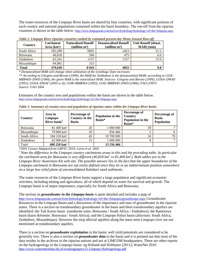
The water resources of the Limpopo River basin are shared by four countries, with significant portions of each country and national populations contained within the basin boundary. The run-off from the riparian countries is shown in the table below: http://www.limpoporak.com/en/river/hydrology/hydrology+of+the+limpopo.aspx Table 2. Limpopo River riparian countries ranked by estimated present-day Mean Annual Run-off.
Country Catchment Area (km²)
Naturalised Runoff (million m³)
Denaturalised Runoff (million m³)
Unit Runoff (denat. MAR) (mm)
South Africa 185,298 6065 2423 21.2 Botswana 46,818 506 475 6.6 Zimbabwe 62,541 1157 1157 15.6 Mozambique 84,981 315 Total 379,638 8 043 4055 9.8 * Denaturalised MAR will change when utilization of the Letsibogo Dam increases. ** According to Görgens and Boroto (1999), the MAR for Zimbabwe is the denaturalised MAR; according to GOZ–MRRWD–DWD (1984), the given MAR is the naturalized MAR. Sources: Görgens and Boroto (1999); GOSA–DWAF (1991); GOSA–DWAF (2003 a–d); GOB–MMRWA (1992); GOZ–MRRWD–DWD (1984); FAO (1997) Source: FAO 2004 Estimates of the country area and populations within the basin are shown in the table below. http://www.limpoporak.com/en/river/hydrology/hydrology+of+the+limpopo.aspx Table 3. Summary of country-area and population of riparian states within the Limpopo River basin.
*2001 Census Adapted from LBPTC 2010; Leira et al. 2002 1 Note the difference in the Limpopo country catchments areas in this and the preceding table. In particular the catchment area for Botswana is very different (46,818 km2 vs 81,400 km2). Both tables are in the Limpopo River Awareness Kit web site. The possible answer lies in the fact that the upper boundaries of the Limpopo catchment in Botswana are not easily defined since they lie in an indeterminate position somewhere on a large low relief plane of unconsolidated Kalahari sand sediments. The water resources of the Limpopo River basin support a large population and significant economic activities, including mining and agriculture, all of which depend on water for survival and growth. The Limpopo basin is of major importance, especially for South Africa and Botswana. The section on groundwater in the Limpopo basin is quite detailed and includes a map of http://www.limpoporak.com/en/river/hydrology/hydrology+of+the+limpopo/groundwater.aspx Groundwater Resources in the Limpopo Basin and a discussion of the importance and uses of groundwater in the riparian states. There is a section on transboundary groundwater in the basin and three transboundary aquifers are identified: the Tuli Karoo basin (sandstone units: Botswana / South Africa / Zimbabwe); the Ramotswa basin (karst dolomite: Botswana / South Africa); and the Limpopo Pafuri basin (alluvium: South Africa, Zimbabwe, Mozambique). However the strip alluvial aquifers along the main stem Limpopo river are not mentioned as transboundary aquifers. There is a section on groundwater exploitation in the basin; well yield potentials are considered to be generally low. There is also a section on groundwater data in the basin and it is pointed out that most of the data resides in the archives in the riparian nations and not at LIMCOM headquarters. There are other reports on the hydrogeology in the Limpopo basin: eg Holland and Witthuser (2011); WaterNet 2010 http://www.waternetonline.ihe.nl/workingpapers/12 Limpopo Hydrogeology.pdf
Country Area in Limpopo River basin1
Percentage of Country in the Basin
Population in the Basin*
Percentage of Country Population in the Basin*
Percentage of Basin Population
Botswana 81 400 km² 20 1 000 000 59 7 Mozambique 79 800 km² 20 856 466 5 6 South Africa 184 150 km² 45 10 700 000 24 79 Zimbabwe 62 900 km² 15 1 000 000 9 7 Total 408 250 km² 13 556 466
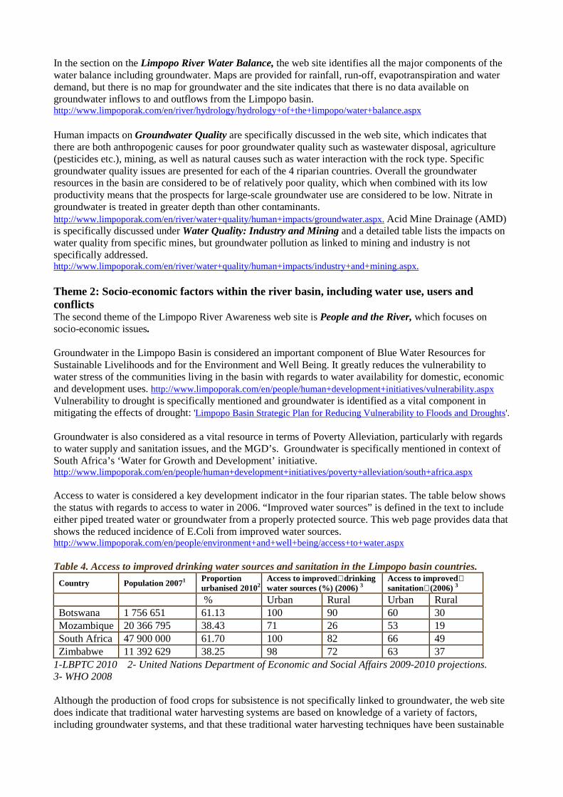
In the section on the Limpopo River Water Balance, the web site identifies all the major components of the water balance including groundwater. Maps are provided for rainfall, run-off, evapotranspiration and water demand, but there is no map for groundwater and the site indicates that there is no data available on groundwater inflows to and outflows from the Limpopo basin. http://www.limpoporak.com/en/river/hydrology/hydrology+of+the+limpopo/water+balance.aspx Human impacts on Groundwater Quality are specifically discussed in the web site, which indicates that there are both anthropogenic causes for poor groundwater quality such as wastewater disposal, agriculture (pesticides etc.), mining, as well as natural causes such as water interaction with the rock type. Specific groundwater quality issues are presented for each of the 4 riparian countries. Overall the groundwater resources in the basin are considered to be of relatively poor quality, which when combined with its low productivity means that the prospects for large-scale groundwater use are considered to be low. Nitrate in groundwater is treated in greater depth than other contaminants. http://www.limpoporak.com/en/river/water+quality/human+impacts/groundwater.aspx. Acid Mine Drainage (AMD) is specifically discussed under Water Quality: Industry and Mining and a detailed table lists the impacts on water quality from specific mines, but groundwater pollution as linked to mining and industry is not specifically addressed. http://www.limpoporak.com/en/river/water+quality/human+impacts/industry+and+mining.aspx. Theme 2: Socio-economic factors within the river basin, including water use, users and conflicts The second theme of the Limpopo River Awareness web site is People and the River, which focuses on socio-economic issues. Groundwater in the Limpopo Basin is considered an important component of Blue Water Resources for Sustainable Livelihoods and for the Environment and Well Being. It greatly reduces the vulnerability to water stress of the communities living in the basin with regards to water availability for domestic, economic and development uses. http://www.limpoporak.com/en/people/human+development+initiatives/vulnerability.aspx Vulnerability to drought is specifically mentioned and groundwater is identified as a vital component in mitigating the effects of drought: 'Limpopo Basin Strategic Plan for Reducing Vulnerability to Floods and Droughts'. Groundwater is also considered as a vital resource in terms of Poverty Alleviation, particularly with regards to water supply and sanitation issues, and the MGD’s. Groundwater is specifically mentioned in context of South Africa’s ‘Water for Growth and Development’ initiative. http://www.limpoporak.com/en/people/human+development+initiatives/poverty+alleviation/south+africa.aspx Access to water is considered a key development indicator in the four riparian states. The table below shows the status with regards to access to water in 2006. “Improved water sources” is defined in the text to include either piped treated water or groundwater from a properly protected source. This web page provides data that shows the reduced incidence of E.Coli from improved water sources. http://www.limpoporak.com/en/people/environment+and+well+being/access+to+water.aspx Table 4. Access to improved drinking water sources and sanitation in the Limpopo basin countries.
Country Population 20071 Proportion urbanised 20102
Access to improved�drinking water sources (%) (2006) 3
Access to improved� sanitation�(2006) 3
% Urban Rural Urban Rural Botswana 1 756 651 61.13 100 90 60 30 Mozambique 20 366 795 38.43 71 26 53 19 South Africa 47 900 000 61.70 100 82 66 49 Zimbabwe 11 392 629 38.25 98 72 63 37
1-LBPTC 2010 2- United Nations Department of Economic and Social Affairs 2009-2010 projections. 3- WHO 2008 Although the production of food crops for subsistence is not specifically linked to groundwater, the web site does indicate that traditional water harvesting systems are based on knowledge of a variety of factors, including groundwater systems, and that these traditional water harvesting techniques have been sustainable
for generations, supplying water for domestic purposes and nutrition gardens. http://www.limpoporak.com/en/people/people+of+the+basin/cultural+diversity/indigenous+traditional+knowledge.aspx Theme 3: Governance of the basin water resources at all stakeholder levels. Under the theme of Governance, groundwater is referred to five times as follows:
1. The first reference is to an international example of river basin management in the Danube River basin. This section is included in the web site merely to provide an example of successful transboundary aquifer / groundwater management.
2. The next reference is to the SADC Regional Strategic Action Plan where a SADC regional Groundwater Management Program is indicated for both RSAP-1 and RSAP-2. http://www.limpoporak.com/en/governance/sadc/sadc+action+plan.aspx. There is a specific Groundwater Management Program in SADC – RWR 3. The LIMCOM program has not in the past and does not at present have any active transboundary aquifer management programs, although these are not precluded in any way by the LIMCOM agreement.
3. The third reference to groundwater is in the LIMCOM agreement: http://www.limpoporak.com/en/governance/water+governance+in+the+limpopo+basin/agreement.aspx. Article 1 of the LIMCOM agreement defines the Limpopo watercourse as a system of surface and groundwaters of the Limpopo, parts of which are situated in the territories of the Contracting Parties. Article 3 presents the objectives of the commission: “The Objectives of the Commission shall be to advise the Contracting Parties and provide recommendations on the uses of the Limpopo, its tributaries and its waters for purpose and measures of protection, preservation and management of the Limpopo.” As can be seen from this, LIMCOM is an advisory multi-state organization that has as its core objective the wise and balanced use of all the waters, including groundwater, in the Limpopo basin.
4. The fourthreference to groundwater refers to Groundwater in the national laws of Botswana. http://www.limpoporak.com/en/governance/water+governance+in+the+limpopo+basin/national+policies+and+laws/botswana.aspx
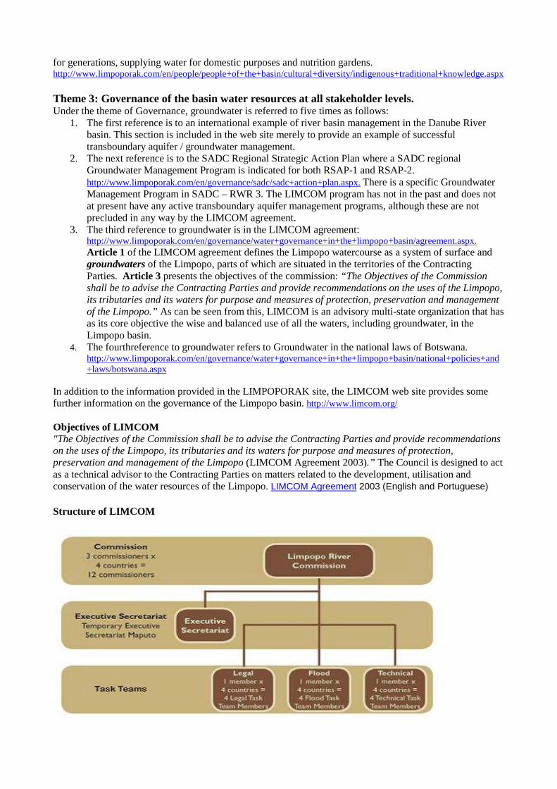
In addition to the information provided in the LIMPOPORAK site, the LIMCOM web site provides some further information on the governance of the Limpopo basin. http://www.limcom.org/ Objectives of LIMCOM "The Objectives of the Commission shall be to advise the Contracting Parties and provide recommendations on the uses of the Limpopo, its tributaries and its waters for purpose and measures of protection, preservation and management of the Limpopo (LIMCOM Agreement 2003).” The Council is designed to act as a technical advisor to the Contracting Parties on matters related to the development, utilisation and conservation of the water resources of the Limpopo. LIMCOM Agreement 2003 (English and Portuguese)
Structure of LIMCOM
The LIMCOM secretariat is based in Maputo, Mozambique, and is staffed by the LIMCOM executive secretary, Eng Sergio Sitoe, supported by a small administrative staff. There are two formal meetings of the commission per year, and a number of ad hoc meetings to deal with river basin management issues, such as flooding, whenever such issues arise. Coordination of LIMCOM activities is carried out by the LIMCOM secretariat. Other LIMCOM publications / documents. Revised SADC Protocol on Shared Watercourses (2000) LBPTC Scoping Study Main Report (2010) LIMCOM Stakeholder Participation Roadmap Workshop Report (2010) Theme 4: Resource Management within the Limpopo River Basin. The first reference to groundwater under this theme occurs in Water Infrastructure- Groundwater in the Basin. http://www.limpoporak.com/en/management/water+infrastructure/in+the+basin.aspx This section gives considerable detail on the groundwater resources, as quoted below. “Groundwater is mainly used in the Limpopo basin for irrigation and rural supplies (Barros 2009). It is noted that over 1 000 boreholes have been drilled in the Limpopo basin, however, very few of these have had continuous water levels measured and there is limited information on depth, geological characteristics, and location (LBPTC 2010). The existing aquifer in the medium lower Limpopo Valley has depths ranging from 80 to 200 m (Barros 2009). The map showing the number of boreholes in the basin is shown in the River Basin section under the Groundwater Chapter.
Very little monitoring of groundwater conditions has been conducted throughout the basin and has only been completed where resources have been overexploited. The main need for groundwater data is due to the interconnected nature of groundwater and surface water interactions as discussed in SW/GW Interactions in the River Basin.”
The basin has a varied hydrogeology and groundwater potential. The western part of the basin in Botswana consists largely of indurated Karoo sediments and Kalahari sands, which have moderate to low groundwater potential. The central parts of the basin in South Africa and Zimbabwe are largely crystalline rocks and fractured aquifers with low groundwater potential. Downstream in the eastern part of the basin in Mozambique, groundwater is stored in extensive sedimentary aquifers but unfortunately much of the groundwater is saline and not well suited to large-scale development (Owen and Madari, 2010). The transboundary aquifers in the basin are identified as follows: Transboundary Aquifers Within the Limpopo River basin there are three transboundary aquifers along the northern border of South Africa with Botswana, Mozambique, and Zimbabwe (Cobbing et al. 2008): • Ramotswa Dolomite • Tuli Karoo • Limpopo Pafuri Aquifer In addition, the Limpopo River alluvial aquifer underlies the Limpopo River, which is a well-known sand river in southern Africa. It is also a transboundary aquifer with unconsolidated alluvial deposits, which fill the river channel and build up the irregular adjoining floodplain. Sustainable utilization of the aquifer is dependent on the management of surface water in the river (Cobbing et al. 2008). A mean saturated thickness is noted at 3.5 m with a hydraulic conductivity of 120 m/day (Cobbing et al. 2008). The aquifer is the broadest east of the Limpopo/Shashe confluence increasing to 500 to 700 m as it enters Mozambique, but narrows to 50 m near the Limpopo/Crocodile confluence. Transmissivity, estimated from pump testing boreholes near the confluence of the Motlouse and Limpopo Rivers, is in the order of 2 700 m³/day (Alemaw 2008).
The following table gives estimated annual groundwater abstractions in the Limpopo River basin (Environmentek, CSIR 2003).
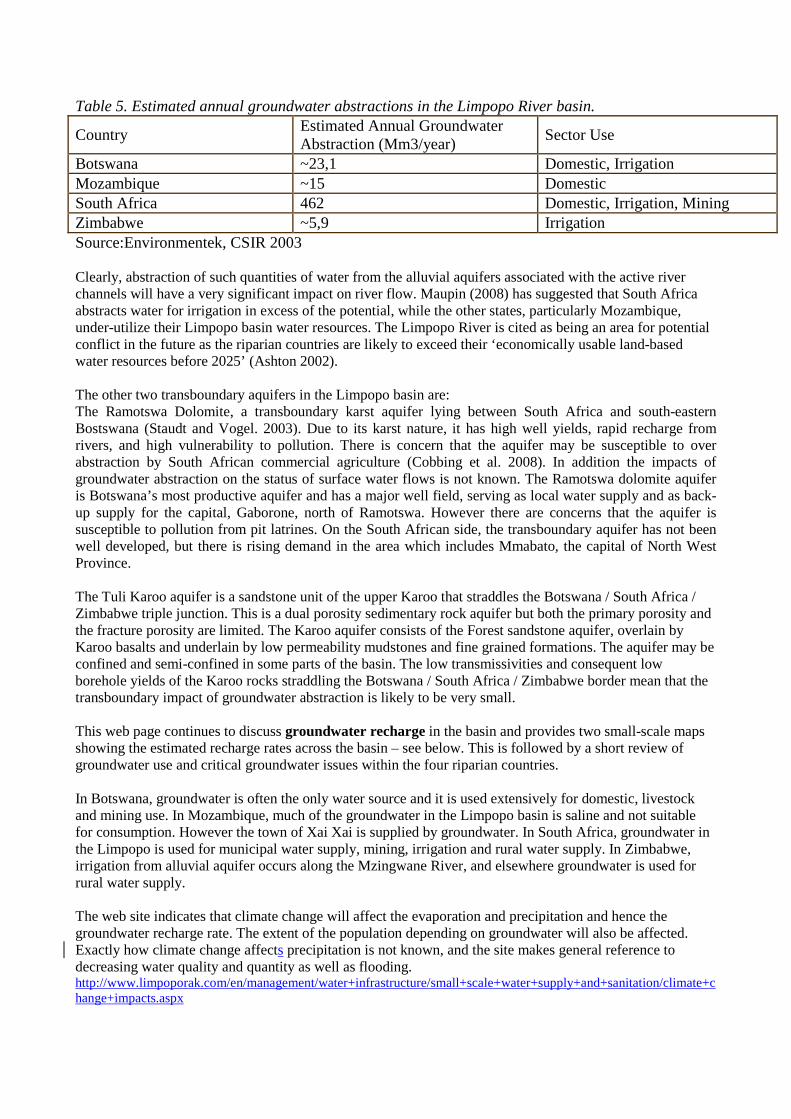
Table 5. Estimated annual groundwater abstractions in the Limpopo River basin.
Country Estimated Annual Groundwater Abstraction (Mm3/year)
Sector Use
Botswana ~23,1 Domestic, Irrigation Mozambique ~15 Domestic South Africa 462 Domestic, Irrigation, Mining Zimbabwe ~5,9 Irrigation Source:Environmentek, CSIR 2003 Clearly, abstraction of such quantities of water from the alluvial aquifers associated with the active river channels will have a very significant impact on river flow. Maupin (2008) has suggested that South Africa abstracts water for irrigation in excess of the potential, while the other states, particularly Mozambique, under-utilize their Limpopo basin water resources. The Limpopo River is cited as being an area for potential conflict in the future as the riparian countries are likely to exceed their ‘economically usable land-based water resources before 2025’ (Ashton 2002). The other two transboundary aquifers in the Limpopo basin are: The Ramotswa Dolomite, a transboundary karst aquifer lying between South Africa and south-eastern Bostswana (Staudt and Vogel. 2003). Due to its karst nature, it has high well yields, rapid recharge from rivers, and high vulnerability to pollution. There is concern that the aquifer may be susceptible to over abstraction by South African commercial agriculture (Cobbing et al. 2008). In addition the impacts of groundwater abstraction on the status of surface water flows is not known. The Ramotswa dolomite aquifer is Botswana’s most productive aquifer and has a major well field, serving as local water supply and as back-up supply for the capital, Gaborone, north of Ramotswa. However there are concerns that the aquifer is susceptible to pollution from pit latrines. On the South African side, the transboundary aquifer has not been well developed, but there is rising demand in the area which includes Mmabato, the capital of North West Province.
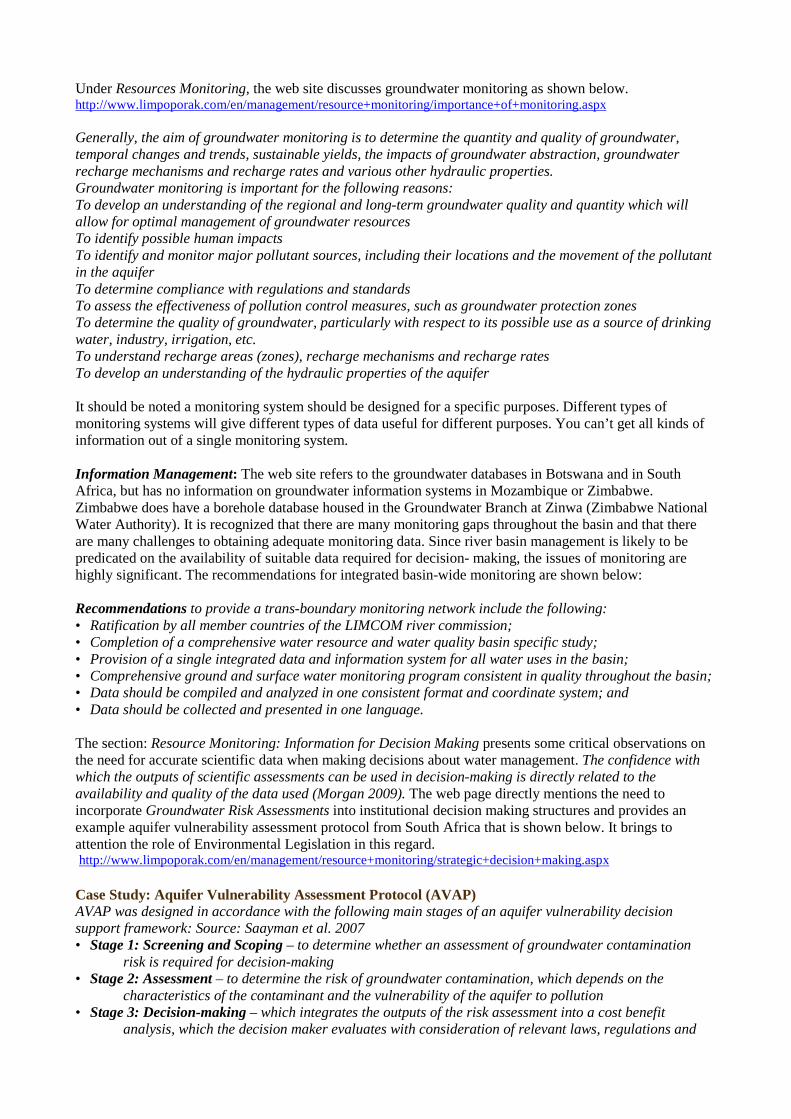
The Tuli Karoo aquifer is a sandstone unit of the upper Karoo that straddles the Botswana / South Africa / Zimbabwe triple junction. This is a dual porosity sedimentary rock aquifer but both the primary porosity and the fracture porosity are limited. The Karoo aquifer consists of the Forest sandstone aquifer, overlain by Karoo basalts and underlain by low permeability mudstones and fine grained formations. The aquifer may be confined and semi-confined in some parts of the basin. The low transmissivities and consequent low borehole yields of the Karoo rocks straddling the Botswana / South Africa / Zimbabwe border mean that the transboundary impact of groundwater abstraction is likely to be very small. This web page continues to discuss groundwater recharge in the basin and provides two small-scale maps showing the estimated recharge rates across the basin – see below. This is followed by a short review of groundwater use and critical groundwater issues within the four riparian countries. In Botswana, groundwater is often the only water source and it is used extensively for domestic, livestock and mining use. In Mozambique, much of the groundwater in the Limpopo basin is saline and not suitable for consumption. However the town of Xai Xai is supplied by groundwater. In South Africa, groundwater in the Limpopo is used for municipal water supply, mining, irrigation and rural water supply. In Zimbabwe, irrigation from alluvial aquifer occurs along the Mzingwane River, and elsewhere groundwater is used for rural water supply. The web site indicates that climate change will affect the evaporation and precipitation and hence the groundwater recharge rate. The extent of the population depending on groundwater will also be affected. Exactly how climate change affects precipitation is not known, and the site makes general reference to decreasing water quality and quantity as well as flooding. http://www.limpoporak.com/en/management/water+infrastructure/small+scale+water+supply+and+sanitation/climate+change+impacts.aspx
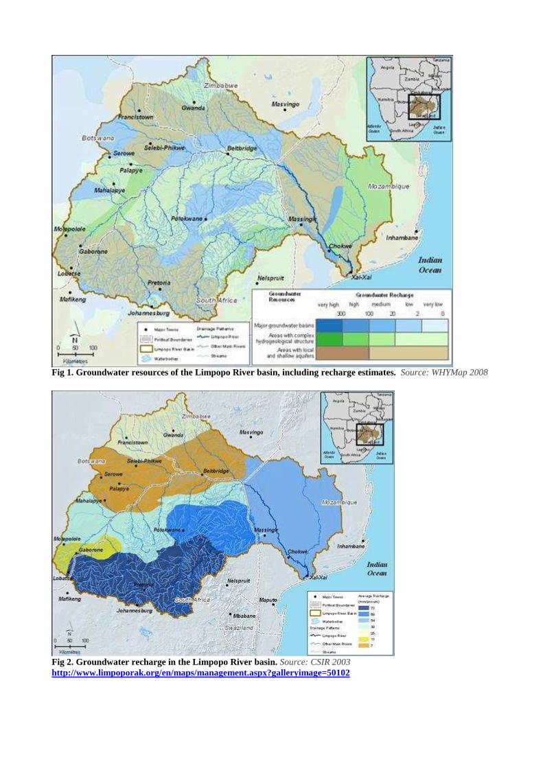
Fig 1. Groundwater resources of the Limpopo River basin, including recharge estimates. Source: WHYMap 2008
Fig 2. Groundwater recharge in the Limpopo River basin. Source: CSIR 2003 http://www.limpoporak.org/en/maps/management.aspx?galleryimage=50102
Under Resources Monitoring, the web site discusses groundwater monitoring as shown below. http://www.limpoporak.com/en/management/resource+monitoring/importance+of+monitoring.aspx Generally, the aim of groundwater monitoring is to determine the quantity and quality of groundwater, temporal changes and trends, sustainable yields, the impacts of groundwater abstraction, groundwater recharge mechanisms and recharge rates and various other hydraulic properties. Groundwater monitoring is important for the following reasons: To develop an understanding of the regional and long-term groundwater quality and quantity which will allow for optimal management of groundwater resources To identify possible human impacts To identify and monitor major pollutant sources, including their locations and the movement of the pollutant in the aquifer To determine compliance with regulations and standards To assess the effectiveness of pollution control measures, such as groundwater protection zones To determine the quality of groundwater, particularly with respect to its possible use as a source of drinking water, industry, irrigation, etc. To understand recharge areas (zones), recharge mechanisms and recharge rates To develop an understanding of the hydraulic properties of the aquifer It should be noted a monitoring system should be designed for a specific purposes. Different types of monitoring systems will give different types of data useful for different purposes. You can’t get all kinds of information out of a single monitoring system. Information Management: The web site refers to the groundwater databases in Botswana and in South Africa, but has no information on groundwater information systems in Mozambique or Zimbabwe. Zimbabwe does have a borehole database housed in the Groundwater Branch at Zinwa (Zimbabwe National Water Authority). It is recognized that there are many monitoring gaps throughout the basin and that there are many challenges to obtaining adequate monitoring data. Since river basin management is likely to be predicated on the availability of suitable data required for decision- making, the issues of monitoring are highly significant. The recommendations for integrated basin-wide monitoring are shown below: Recommendations to provide a trans-boundary monitoring network include the following: • Ratification by all member countries of the LIMCOM river commission; • Completion of a comprehensive water resource and water quality basin specific study; • Provision of a single integrated data and information system for all water uses in the basin; • Comprehensive ground and surface water monitoring program consistent in quality throughout the basin; • Data should be compiled and analyzed in one consistent format and coordinate system; and • Data should be collected and presented in one language. The section: Resource Monitoring: Information for Decision Making presents some critical observations on the need for accurate scientific data when making decisions about water management. The confidence with which the outputs of scientific assessments can be used in decision-making is directly related to the availability and quality of the data used (Morgan 2009). The web page directly mentions the need to incorporate Groundwater Risk Assessments into institutional decision making structures and provides an example aquifer vulnerability assessment protocol from South Africa that is shown below. It brings to attention the role of Environmental Legislation in this regard. http://www.limpoporak.com/en/management/resource+monitoring/strategic+decision+making.aspx Case Study: Aquifer Vulnerability Assessment Protocol (AVAP) AVAP was designed in accordance with the following main stages of an aquifer vulnerability decision support framework: Source: Saayman et al. 2007 • Stage 1: Screening and Scoping – to determine whether an assessment of groundwater contamination
risk is required for decision-making • Stage 2: Assessment – to determine the risk of groundwater contamination, which depends on the
characteristics of the contaminant and the vulnerability of the aquifer to pollution • Stage 3: Decision-making – which integrates the outputs of the risk assessment into a cost benefit
analysis, which the decision maker evaluates with consideration of relevant laws, regulations and
guidelines and the principles and values of society Resource Monitoring: Existing Monitoring: The issue of very high transmission loss / river flow decline from the Limpopo River along its course has been identified. Clearly the groundwater abstraction from alluvial aquifers within the river channels has an impact on the scale of these losses. http://www.limpoporak.com/en/management/resource+monitoring/existing+monitoring.aspx Water Demand: http://www.limpoporak.com/en/management/water+demand.aspx Groundwater is specifically mentioned: Assessing water demands in the Limpopo River basin is complicated by the fact that there are four countries sharing the basin, numerous sectors and services that require water and uncertainties as to availability of water - especially with respect to groundwater resources and the potential impacts of climate change. Water demand management studies suggest that the proposed irrigation potential of 15,000 ha from the Limpopo basin in Botswana, with 44% coming from groundwater, should be lowered to 5000 ha. limpoporak.com/en/management/water+infrastructure/irrigation+infrastructure/botswana.aspx Water Use in the Basin http://www.limpoporak.com/en/management/water+demand/water+use/water+use.aspx Figures for the water use in the basin are presented on a country basis. Groundwater demand is mentioned with respect to rural water supply. Conservation and Water Re-Use limpoporak.com/en/management/water+demand/conservation+and+reuse.aspx The recycling / artificial recharge of partially treated wastewater to groundwater is seen as a possible strategy to cope with increasing water demand in Botswana. Water Allocation http://www.limpoporak.com/en/management/water+demand/water+use/allocation.aspx This section speaks of the requirement for permits for all commercial water use, but the case of groundwater abstraction permits is only mentioned specifically in the case of Botswana. Water Infrastructure refers to groundwater infrastructure such as well fields and boreholes and discusses the need for sufficient investment to construct, maintain and repair water infrastructure in general. http://www.limpoporak.com/en/management/water+infrastructure.aspx. Small Scale Water Supply and Sanitation, the subject of groundwater comes up repeatedly, and it is stated that the arid regions of the basin are highly dependent on groundwater, particularly domestic water for small-scale users in rural areas. It is also noted that borehole water is often consumed without treatment and groundwater pollution can occur. http://www.limpoporak.com/en/management/water+infrastructure/small+scale+water+supply+and+sanitation.aspx Development, Operation and Maintenance of Water Infrastructure http://www.limpoporak.com/en/management/water+infrastructure/development+operation+maintenance.aspx - Groundwater is mentioned, but only in a peripheral way. A SADC study has indicated that much of the groundwater infrastructure is not functional at any point in time and that it needs continuous maintenance. Such issues are generally considered to be the responsibility of the national authority and not the RBO. The Value of Water: Social Costs The value of water with regards to groundwater replenishment is indicated here ranging between US$10-90 /ha /year. limpoporak.com/en/management/value+of+water/environmental+costs/social+costs.aspx Theme 5: Technical Capacity and Capacity Building Requirements for the RBO Governance > Integrated Water Resources Management > Capacity Development http://www.limpoporak.com/en/governance/integrated+management/capacity+development.aspx. This page provides a general discussion of the terms ‘capacity’ and ‘capacity development’ and identifies individual, organizational and institutional levels for capacity and capacity development, as expressed below “’Capacity’ means the ability of people, organisations and society as a whole to successfully manage their affairs, and ‘capacity building’ means a process whereby people organisations and society as a whole unleash, strengthen, create, adapt and maintain capacity over time” (OECD-DAC 2006).
The web site goes on to state: Many river basin organisations are not fully able to deal with the complex and
dynamic nature of transboundary water management. Challenges include excessive bureaucracy (which results in over-regulation), resourcing issues with staff, programming that is technically oriented rather than strategic, and, too often, weak decision making and conflicting priorities (Pres 2008).
The four main steps for capacity development in the context of transboundary river basin management are identified as: 1) Understanding the International and Country Contexts 2) Identifying and Supporting Sources of Country-Owned Change 3) Delivering Support 4) Learning from Experiences and Sharing Lessons Governance > Integrated Water Resources Management > Capacity Development > Organisations. This page lists a number of capacity building organizations that operate within the Limpopo basin. Global Water Partnership Southern Africa: http://www.gwp.org/ WaterNet: http://www.waternetonline.ihe.nl/ Cap-Net: http://www.cap-net.org/ FETWater: http://www.fetwater.co.za/ Water Research Commission (WRC): http://www.wrc.org.za/ In addition the page mentions other organizations such as IWMI (International Water Management Institution), WARFSA (Water Research Fund for Southern Africa) and the various universities in the region. Governance > Southern African Development Community > SADC Action Plan Capacity Building is indicated as a pillar of Regional Strategic Action Plans, RSAP1 and RSAP2 for water resources management. Capacity building for RBO’s is specifically identified.
CB 4 3 Capacity Building for Joint Integrated Basin Management
Strengthening River Basin Organisations
Governance > Stakeholders > Non-Governmental Organisations. Several NGOs that work in the water sector in the Limpopo basin are specifically identified and those that do capacity building are listed. Summary: The LIMPOPORAK web site provides a good understanding of how LIMCOM and the riparian states view the groundwater resources in the Limpopo basin, and identifies many of the threats, challenges and opportunities for improved groundwater management in the basin as a whole. Together with the interviews of key management and professional within the Limpopo Commission, this document will provide a good basis for assessing the future needs of LIMCOM with regards to groundwater management.
Interviews: Overview: One of the fundamental components of this RBO survey methodology has been direct interviews with key personnel both within the River Basin Organization (LIMCOM) and also with representatives from the riparian states as indicated below:
• Interview with the Executive Secretary for the LIMCOM River Basin Organization (and other personnel if available). This interview took place in Maputo at the LIMCOM headquarters.
• Interviews with the representatives of each of the riparian states to the LIMCOM board. These were carried out by telephone except in Zimbabwe, where the representative of the Ministry of Water Development was interviewed in person.
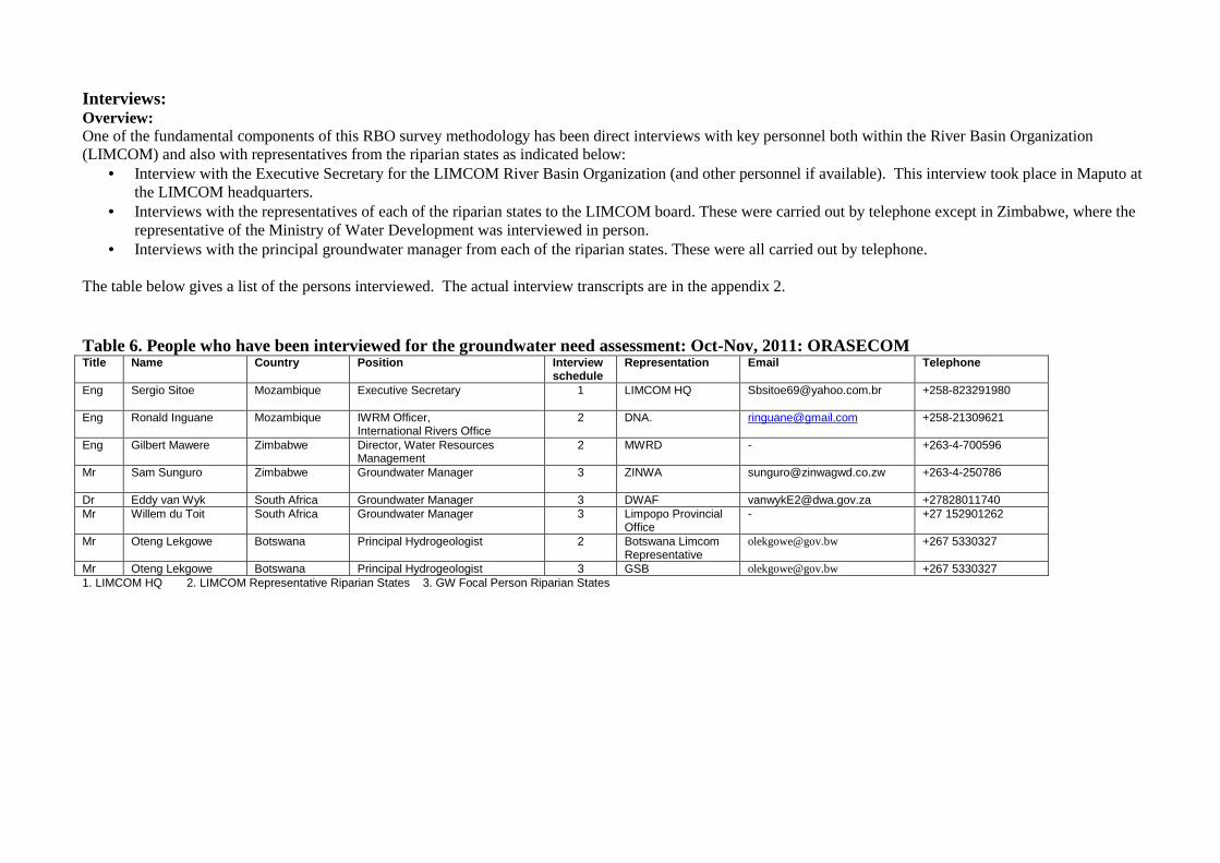
• Interviews with the principal groundwater manager from each of the riparian states. These were all carried out by telephone. The table below gives a list of the persons interviewed. The actual interview transcripts are in the appendix 2. Table 6. People who have been interviewed for the groundwater need assessment: Oct-Nov, 2011: ORASECOM Title Name Country Position Interview
schedule Representation Email Telephone
Eng Sergio Sitoe Mozambique Executive Secretary 1
LIMCOM HQ [email protected] +258-823291980
Eng Ronald Inguane Mozambique IWRM Officer, International Rivers Office
2 DNA. [email protected] +258-21309621
Eng Gilbert Mawere Zimbabwe Director, Water Resources Management
2 MWRD - +263-4-700596
Mr Sam Sunguro
Zimbabwe Groundwater Manager 3 ZINWA [email protected] +263-4-250786
Dr Eddy van Wyk South Africa Groundwater Manager 3 DWAF [email protected] +27828011740 Mr Willem du Toit South Africa Groundwater Manager 3 Limpopo Provincial
Office - +27 152901262
Mr Oteng Lekgowe Botswana Principal Hydrogeologist 2 Botswana Limcom Representative
[email protected] +267 5330327
Mr Oteng Lekgowe Botswana Principal Hydrogeologist 3 GSB [email protected] +267 5330327 1. LIMCOM HQ 2. LIMCOM Representative Riparian States 3. GW Focal Person Riparian States

15
Analysis of the Interviews. The interviews revealed that there are different levels of interaction with LIMCOM. The LIMCOM secretariat and the Mozambican country representative indicate that LIMCOM is important and highly valued for its work in managing flood waters in particular by means of coordinating dam releases in the rainy season. Other country representatives (eg Zimbabwe) agreed with this assessment and stress that LIMCOM functions principally to manage river flows in the Limpopo basin and to provide a forum where riparian states can meet within a legal framework to discuss river management. All interviewees agreed that LIMCOM has not to date been involved in transboundary groundwater management and there is no protocol in place to ensure data sharing. LIMCOM is not presently considering a role in groundwater management since it has neither the technical capacity nor the mandate. Interviewees indicated that the SADC water sector (eg. the Groundwater Management Institute, GMI) might be a more appropriate platform to manage transboundary groundwater given the lack of capacity at LIMCOM. There are concerns that archive data is not always equally forthcoming from different states. Such observations as well as information gleaned from the base-line survey are used in the following SWOT analysis. SWOT Analysis. There are only three recognized transboundary groundwater basins in the Limpopo basin: the Ramotswa dolomite, the Tuli aquifer and the Limpopo aquifer. These are all rather localized aquifer systems and the Tuli aquifer system is not heavily exploited. The Ramotswa aquifer is presently used for Gaborone water supply, but there is a rising irrigation demand from South African farmers. The Limpopo aquifer is presently considered to be localized at the Mozambique, South Africa, Zimbabwe triple junction. However abstraction from Limpopo main stem and tributary channel sands for large scale irrigation in South Africa, and to a lesser extent Zimbabwe, certainly uses large volumes of water that are considered to have a direct impact on surface flows in these rivers. These groundwater abstractions are therefore of direct interest to LIMCOM and impact on its role as the manager of the Limpopo basin water resources. It is in this context that the SWOT analysis is carried out. The SWOT analysis focuses on four (4) components of the RBO’s potential role and activities. These are listed below:
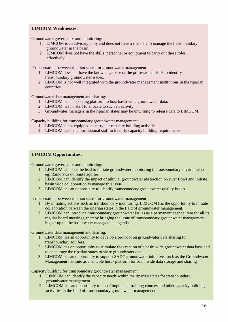
1. Groundwater governance and monitoring by LIMCOM. 2. Collaboration with and between riparian states with regards to groundwater management. 3. Groundwater data management and sharing. 4. Capacity building for groundwater management.
LIMCOM Strengths. Groundwater governance and monitoring:
1. LIMCOM has a transboundary mandate. 2. LIMCOM can provide a platform for transboundary groundwater monitoring and a forum for
transboundary groundwater governance. Collaboration between riparian states for groundwater management:
1. LIMCOM has strong political support from riparian states and is well placed to play a facilitating role in transboundary groundwater management.
Groundwater data management and sharing:
1. As the international organization that manages Limpopo basin water, LIMCOM has the legal and political mandate to host relevant transboundary groundwater data from the riparian states.
Capacity building for transboundary groundwater management:
1. LIMCOM is well placed to host transboundary groundwater capacity building activities and training programs.
16
LIMCOM Weaknesses. Groundwater governance and monitoring:
1. LIMCOM is an advisory body and does not have a mandate to manage the transboundary groundwater in the basin.
2. LIMCOM does not have the skills, personnel or equipment to carry out these roles effectively.
Collaboration between riparian states for groundwater management:
1. LIMCOM does not have the knowledge base or the professional skills to identify transboundary groundwater issues.
2. LIMCOM is not well integrated with the groundwater management institutions in the riparian countries.
Groundwater data management and sharing:
1. LIMCOM has no existing platform to host basin-wide groundwater data. 2. LIMCOM has no staff to allocate to such an activity. 3. Groundwater managers in the riparian states may be unwilling to release data to LIMCOM.
Capacity building for transboundary groundwater management:
1. LIMCOM is not equipped to carry out capacity building activities. 2. LIMCOM lacks the professional staff to identify capacity building requirements.
LIMCOM Opportunities. Groundwater governance and monitoring:
1. LIMCOM can take the lead to initiate groundwater monitoring in transboundary environments eg: Ramotswa dolomite aquifer.
2. LIMCOM can identify the impact of alluvial groundwater abstraction on river flows and initiate basin wide collaboration to manage this issue.
3. LIMCOM has an opportunity to identify transboundary groundwater quality issues. Collaboration between riparian states for groundwater management:
1. By initiating actions such as transboundary monitoring, LIMCOM has the opportunity to initiate collaboration between the riparian states in the field of groundwater management.
2. LIMCOM can introduce transboundary groundwater issues as a permanent agenda item for all its regular board meetings, thereby bringing the issue of transboundary groundwater management higher up on the basin water management agenda.
Groundwater data management and sharing:
1. LIMCOM has an opportunity to develop a protocol on groundwater data sharing for transboundary aquifers.
2. LIMCOM has on opportunity to stimulate the creation of a basin wide groundwater data base and to encourage the riparian states to share groundwater data.
3. LIMCOM has an opportunity to support SADC groundwater initiatives such as the Groundwater Management Institute as a suitable host / platform for basin wide data storage and sharing.
Capacity building for transboundary groundwater management:
1. LIMCOM can identify the capacity needs within the riparian states for transboundary groundwater management.
2. LIMCOM has an opportunity to host / implement training courses and other capacity building activities in the field of transboundary groundwater management.

17
Conclusions. All interviewees do recognize the importance of transboundary groundwater in the Limpopo basin, and in particular are conceptually aware of the potential impacts of large-scale groundwater abstractions on river flows. Neither LIMCOM nor any of the riparian states are presently engaged in any transboundary groundwater management, and there are no present conflicts on the shared aquifers. Neither LIMCOM nor any of the interviewees indicated any critical transboundary groundwater problem. The impact of groundwater abstraction, particularly from alluvial aquifers, on surface flows in the Limpopo basin was cited as a potential concern. It was acknowledged that large volumes of alluvial groundwater are pumped for irrigation in South Africa, and to a lesser extent in Zimbabwe. An increase in such alluvial groundwater abstraction is possible in all riparian states with un-quantified impact on river flows. The Ramotswa dolomite aquifer may face increasing competition from abstraction for Gaborone in Botswana and irrigation in South Africa. As yet there is no transboundary monitoring of this aquifer. Water quality associated with coal mining near the Botswana / South Africa border was cited as a possible future problem. There is insufficient capacity in LIMCOM to adequately assess the resource challenges faced by the transboundary aquifers, and it is possible that LIMCOM would only become aware of the issues once the impacts are already being experienced by (ground)water users.
LIMCOM Threats. Groundwater governance and monitoring:
1. LIMCOM may lack the financial resources to carry out transboundary groundwater actions. 2. Riparian states may lack the will and the resources to carry out monitoring of transboundary
aquifers. 3. Some riparian states may have insufficient capacity to monitor transboundary groundwater. 4. LIMCOM has no legal mandate to manage transboundary groundwater.
Collaboration between riparian states for groundwater management:
1. Riparian client states may reject LIMCOM’s role in managing transboundary aquifers. 2. Technical complexities may limit LIMCOM’s ability to resolve conflicts arising around over-
pumped transboundary groundwater systems. 3. LIMCOM has no legal power to enforce transboundary groundwater management decisions.
Groundwater data management and sharing:
1. Some riparian states may be unwilling to share groundwater data. 2. Riparian states have different data archive systems that may be incompatible.
Capacity building for transboundary groundwater management:
1. Riparian states may not accept the need for capacity development with regards to transboundary groundwater management.
2. Funding for such capacity development may be unavailable.
18
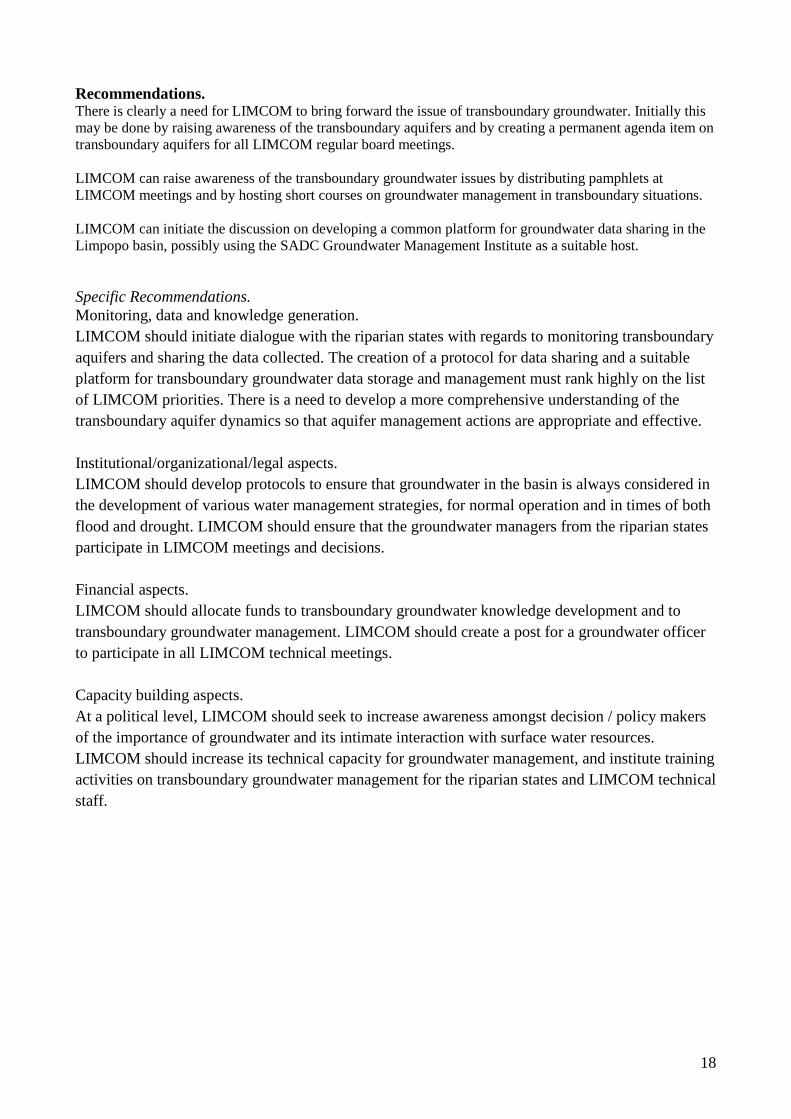
Recommendations. There is clearly a need for LIMCOM to bring forward the issue of transboundary groundwater. Initially this may be done by raising awareness of the transboundary aquifers and by creating a permanent agenda item on transboundary aquifers for all LIMCOM regular board meetings. LIMCOM can raise awareness of the transboundary groundwater issues by distributing pamphlets at LIMCOM meetings and by hosting short courses on groundwater management in transboundary situations. LIMCOM can initiate the discussion on developing a common platform for groundwater data sharing in the Limpopo basin, possibly using the SADC Groundwater Management Institute as a suitable host. Specific Recommendations. Monitoring, data and knowledge generation. LIMCOM should initiate dialogue with the riparian states with regards to monitoring transboundary aquifers and sharing the data collected. The creation of a protocol for data sharing and a suitable platform for transboundary groundwater data storage and management must rank highly on the list of LIMCOM priorities. There is a need to develop a more comprehensive understanding of the transboundary aquifer dynamics so that aquifer management actions are appropriate and effective. Institutional/organizational/legal aspects. LIMCOM should develop protocols to ensure that groundwater in the basin is always considered in the development of various water management strategies, for normal operation and in times of both flood and drought. LIMCOM should ensure that the groundwater managers from the riparian states participate in LIMCOM meetings and decisions. Financial aspects. LIMCOM should allocate funds to transboundary groundwater knowledge development and to transboundary groundwater management. LIMCOM should create a post for a groundwater officer to participate in all LIMCOM technical meetings. Capacity building aspects. At a political level, LIMCOM should seek to increase awareness amongst decision / policy makers of the importance of groundwater and its intimate interaction with surface water resources. LIMCOM should increase its technical capacity for groundwater management, and institute training activities on transboundary groundwater management for the riparian states and LIMCOM technical staff.
19
References: Ashton, P. J. 2002. Avoiding Conflicts over Africa’s Water Resources, Ambio, Vol. 31, No. 3, 236-242. Barros, R. 2009. Integrated Water Resources Management in Mozambique: The case of the Limpopo Basin. Thesis submitted to the Faculty of Environmental Sciences. Federal Institute of Technology Zurich (ETH), Zurich, Switzerland. 85 pp. Cobbing, J.E., P.J. Hobbs, R. Meyer and J. Davies. 2008. A Critical Overview of Transboundary Aquifers shared by South Africa. Hydrogeology Journal. DOI 10.1007/s10040-008-0285-2. Environmentek, CSIR (Council of Scientific and Industrial Research). 2003. Protection and Strategic Uses of Groundwater Resources in Drought Prone Areas of the SADC Region. Groundwater Situation Analysis of the Limpopo River Basin, Summary Report. Prepared for SADC. CSIR Environmentek Report No. ENV-P-C 2003-047. Holland M and Witthuser K. 2011. Evaluation of geologic and geomorphic influences on borehole productivity in crystalline bedrock aquifers in Limpopo Province, South Africa. Hydrogeology Journal. Vol 19. No 5. LIMCOM – The Limpopo Watercourse Commission. Official website: http://www.limcom.org/ Limpopo River Awareness Kit. 2011. http://www.limpoporak.com/en/default.aspx. (Many references throughout the document come from this web-site. Individual references are identified with the URL in the document) Limpopo Watercourse Commission Agreement. 2003. http://www.limcom.org/ Limpopo Basin Permanent Technical Committee (LBPTC). 2010. Joint Limpopo River Basin Study Scoping Phase. Final Report. BIGCON Consortium. Morgan, K. 2009. Understanding how Data Quality impacts Decision Quality. Research Triangle Institute, Washington, D.C. Maupin A. 2008. The Limcom: a water management commission or a way to express countries unequal powers? 4th International Workshop of Hydro-Hegemony Owen R and Madari N. 2010. Hydrogeology of the Limpopo Basin: Country studies from Mozambique, South Africa and Zimbabwe. WaterNet Working Paper 12. Pres, A. 2008. Capacity Building: A Possible Approach to Improved Water Resources Management. International Journal of Water Resources Development. 24:1, pp.123-129. Southern African Development Community (SADC). 2000. Protocol on Shared Watercourse Systems in the Southern African Development Community (SADC) Region. Southern African Development Community (SADC). 2011. SADC Groundwater and Drought Management Project website. http://sadc-groundwater.org/objective.php . Southern African Development Community (SADC). 2005b. Regional Strategic Action Plan on Integrated Water Resources Development and Management, Annotated Strategic Plan – 2005 – 2010, pp. 68. Staudt M and Vogel H. 2003. Environmental Hydrogeology of Ramotswa. Geological Survey of Botswana / BG
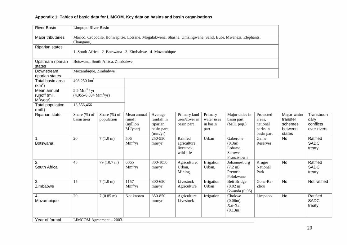
Appendix 1: Tables of basic data for LIMCOM. Key da ta on basins and basin organisations
20
River Basin
Limpopo River Basin
Major tributaries
Marico, Crocodile, Bonwapitse, Lotsane, Mogalakwena, Shashe, Umzingwane, Sand, Bubi, Mwenezi, Elephants, Changane,
Riparian states 1. South Africa 2. Botswana 3. Zimbabwe 4. Mozambique
Upstream riparian states
Botswana, South Africa, Zimbabwe.
Downstream riparian states
Mozambique, Zimbabwe
Total basin area (km2)
408,250 km2
Mean annual runoff (mill. M3/year)
5.5 Mm3 / yr (4,055-8,034 Mm3/yr)
Total population (mill.)
13,556,466
Riparian state Share (%) of basin area
Share (%) of population
Mean annual runoff (million M3/year)
Average rainfall in riparian basin part (mm/yr)
Primary land uses/cover in basin part
Primary water uses in basin part
Major cities in basin part (Mill. pop.)
Protected areas, national parks in basin part
Major water transfer schemes between states
Transboundary conflicts over rivers
1. Botswana
20 7 (1.0 m) 506 Mm3/yr
250-550 mm/yr
Rainfed agriculture, livestock, wild-life
Urban Gaberone (0.3m) Lobatse, Serowe, Francistown
Game Reserves
No Ratified SADC treaty
2. South Africa
45 79 (10.7 m) 6065 Mm3/yr
300-1050 mm/yr
Agriculture, Urban, Mining
Irrigation Urban,
Johannesburg (7.2 m) Pretoria Polokwane
Kruger National Park
No Ratified SADC treaty
3. Zimbabwe
15 7 (1.0 m) 1157 Mm3/yr
300-650 mm/yr
Livestock Agriculture
Irrigation Urban
Beit Bridge (0.02 m) Gwanda (0.05)
Gona-Re-Zhou
No Not ratified
4. Mozambique
20 7 (0.85 m) Not known
350-850 mm/yr
Agriculture Livestock
Irrigation Chokwe (0.06m) Xai-Xai (0.13m)
Limpopo No Ratified SADC treaty
Year of formal LIMCOM Agreement – 2003.
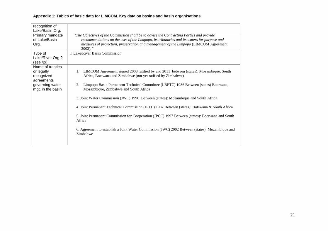
Appendix 1: Tables of basic data for LIMCOM. Key da ta on basins and basin organisations
21
recognition of Lake/Basin Org. Primary mandate of Lake/Basin Org.
"The Objectives of the Commission shall be to advise the Contracting Parties and provide recommendations on the uses of the Limpopo, its tributaries and its waters for purpose and measures of protection, preservation and management of the Limpopo (LIMCOM Agreement 2003).”
Type of Lake/River Org.? (see /2/)
� Lake/River Basin Commission
Name of treaties or legally recognized agreements governing water mgt. in the basin
1. LIMCOM Agreement signed 2003 ratified by end 2011 between (states): Mozambique, South
Africa, Botswana and Zimbabwe (not yet ratified by Zimbabwe)
2. Limpopo Basin Permanent Technical Committee (LBPTC) 1986 Between (states) Botswana, Mozambique, Zimbabwe and South Africa
3. Joint Water Commission (JWC) 1996 Between (states): Mozambique and South Africa
4. Joint Permanent Technical Commission (JPTC) 1987 Between (states): Botswana & South Africa 5. Joint Permanent Commission for Cooperation (JPCC) 1997 Between (states): Botswana and South Africa 6. Agreement to establish a Joint Water Commission (JWC) 2002 Between (states): Mozambique and Zimbabwe
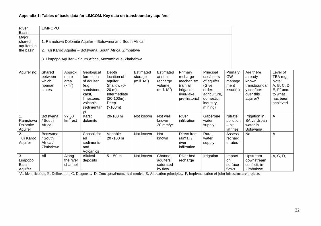
Appendix 1: Tables of basic data for LIMCOM. Key da ta on transboundary aquifers
22
River Basin
LIMPOPO
Major shared aquifers in the basin
1. Ramotswa Dolomite Aquifer – Botswana and South Africa 2. Tuli Karoo Aquifer – Botswana, South Africa, Zimbabwe 3. Limpopo Aquifer – South Africa, Mozambique, Zimbabwe
Aquifer no. Shared between which riparian states
Approximate area (km2)
Geological formation of aquifer (e.g. sandstone, karst, limestone, volcanic, sedimentary)
Depth location of aquifer: Shallow (0-20 m), Intermediate (20-100m), Deep (>100m)
Estimated storage (mill. M3)
Estimated annual recharge volume (mill. M3)
Primary recharge mechanism (rainfall, irrigation, river/lake, pre-historic)
Principal use/users of aquifer (Give order: agriculture, domestic, industry, mining)
Primary GW management issue(s)
Are there already known transboundary conflicts over this aquifer?
Level of TBA mgt. Note: A, B, C, D, E, Fa acc. to what has been achieved
1. Ramotswa Dolomite Aquifer
Botswana / South Africa
?? 50 km2 est
Karst dolomite
20-100 m Not known Not well known 20 mm/yr
River infiltration
Gaberone water supply
Nitrate pollution – pit latrines
Irrigation in SA vs Urban water in Botswana
A
2. Tuli Karoo Aquifer
Botswana / South Africa / Zimbabwe
Consolidated sediments and Volcanics
Variable 20 -100 m
Not known Not known
Direct from rainfall / river infiltration
Rural water supply
Assess recharge rates
No A
3. Limpopo Basin Aquifer
All Along the river channel
Alluival deposits
5 – 50 m Not known Channel aquifers saturated by flow
River bed recharge
Irrigation Impact on surface flows
Upstream downstream conflicts in Zimbabwe
A, C, D,
aA. Identification, B. Delineation, C. Diagnosis, D. Conceptual/numerical model, E. Allocation principles, F. Implementation of joint infrastructure projects
Appendix 2: Interview Transcripts.
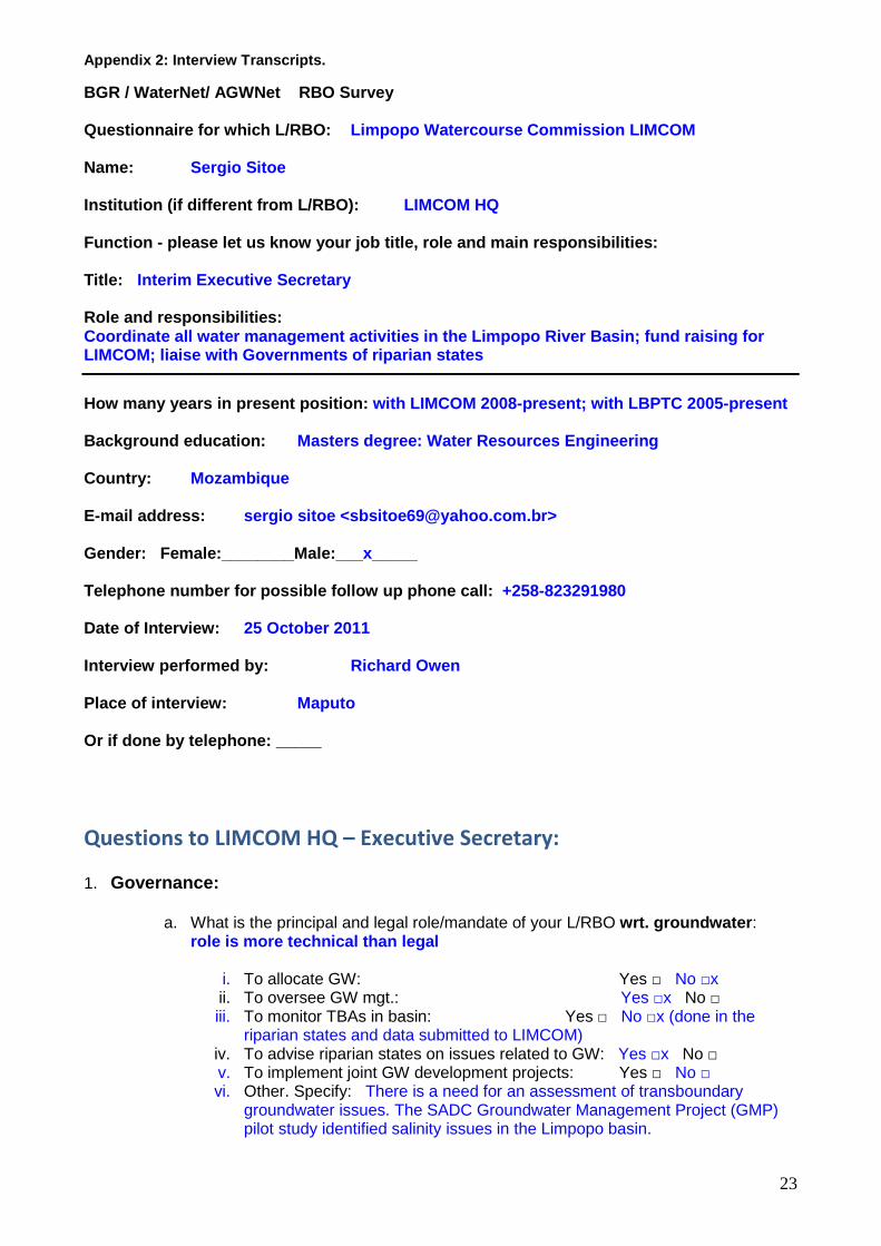
23
BGR / WaterNet/ AGWNet RBO Survey Questionnaire for which L/RBO: Limpopo Watercourse Commission LIMCOM Name: Sergio Sitoe Institution (if different from L/RBO): LIMCOM HQ Function - please let us know your job title, role and main responsibilities: Title: Interim Executive Secretary Role and responsibilities: Coordinate all water management activities in the Limpopo River Basin; fund raising for LIMCOM; liaise with Governments of riparian states
How many years in present position: with LIMCOM 2008-present; with LBPTC 2005-present Background education: Masters degree: Water Resources Engineering Country: Mozambique E-mail address: sergio sitoe <[email protected]> Gender: Female:________Male:___ x_____ Telephone number for possible follow up phone call: +258-823291980 Date of Interview: 25 October 2011 Interview performed by: Richard Owen Place of interview: Maputo Or if done by telephone: _____
Questions to LIMCOM HQ – Executive Secretary: 1. Governance:
a. What is the principal and legal role/mandate of your L/RBO wrt. groundwater : role is more technical than legal
i. To allocate GW: Yes □ No □x ii. To oversee GW mgt.: Yes □x No □ iii. To monitor TBAs in basin: Yes □ No □x (done in the
riparian states and data submitted to LIMCOM) iv. To advise riparian states on issues related to GW: Yes □x No □ v. To implement joint GW development projects: Yes □ No □ vi. Other. Specify: There is a need for an assessment of transboundary
groundwater issues. The SADC Groundwater Management Project (GMP) pilot study identified salinity issues in the Limpopo basin.
Appendix 2: Interview Transcripts.
24
b. Does your L/RBO have a staffed permanent Secretariat? Yes □ No □ At present there is an Executive Secretary, Secretary, Driver and Guard. The riparian states are in the process of recruiting a legal officer, and in future a communications and a technical specialist will be appointed.
c. Does the constitution/agreement establishing your L/RBO specifically/explicitly
address GW and groundwater issues? Yes □ No □
d. If yes, how?
Article 1.2 at the start of the LIMCOM agreement (2003) states: “all waters, including surface and groundwaters…”
e. Which water management instruments/schemes do you use? (e.g. management
plans, action programs, monitoring and information systems, etc.)
LIMCOM are in the process of developing an IWRM management plan and a Monitoring and Evaluation system.
f. To what extent is groundwater already considered in your water management
structure and what actions/initiatives/programmes are you using to foster groundwater management within your organisation? (e.g. groundwater working group at ORASECOM) Groundwater action is not yet part of the organization’s activities. However there is a monograph of the Limpopo presently being developed that includes a thematic groundwater assessment. Based on the results of the monograph, there may be a future requirement groundwater management action.
g. Do you collaborate with organisations/programmes/institutes/projects that have a
groundwater component? (African networks, policy decision makers (e.g. AU, AMCOW, AGWC, etc.) and international donors) Not yet. The SADC Groundwater Drought Management Project didn’t directly liaise with LIMCOM when they set up pilot studies in the lower Limpopo, until LIMCOM called them and enquired about the nature of the study.
h. Are you aware of the AMCOW work plan? Yes □ No □x i. If yes: Are there any activities you have taken on board due to the AMCOW work
plan?
None
j. Do you know about the existence of the UN resolution on transboundary aquifers? Yes □ No □x Comments:
2. Society/collaboration/inclusion:
a. What are the major uses of groundwater within the basin?
Domestic use: Rural water supply and some urban centres eg. Xai Xai in Mozambique. Alluvial aquifers used for irrigation.
Appendix 2: Interview Transcripts.
25
b. What are the main water challenges your basin/lake is confronted with? (e.g. groundwater pollution, (ground-) water shortage, institutional, etc.)
The depth to groundwater in the sedimentary aquifers is too deep. There are water quality issues (high salinity) in these aquifers. There has been a lack of studies on groundwater in the basin and there are reports of declining yields, which needs to be assessed. South Africa is the biggest user of groundwater in the basin, and there is an interest in desalinization of groundwater.
c. Are there great disparities between the water conditions and challenges in
the riparian states?
Yes: in South Africa the issues are water quality and yield; in Mozambique, flooding is the issue and in Botswana, water scarcity is the problem.
d. Also in the level of groundwater development and management?
Mozambique and Zimbabwe do not have well developed groundwater management systems. Botswana and South Africa have advanced groundwater management systems.
e. How is the exchange of knowledge/data and cooperation between the L/RBO and
the riparian states’ water mgt. structures? Exchange of information is good; communication on the development of infrastructure is also good. Data on river-flow and environmental issues is also exchanged because it is required for river basin management. However in terms of groundwater, there is little exchange between LIMCOM and the riparian states.
f. Do you find the commitment of the riparian states to include GW on the political
agenda sufficient? Yes □x No □ g. Does this influence your functionality?
LIMCOM is not yet involved in groundwater management. This would require a link to the groundwater databases in the riparian states and further technical capacity in LIMCOM, but this is not something that is being contemplated at LIMCOM HQ.
h. What are you doing to strengthen the participation of the riparian states? (e.g. are
formal structures, like stakeholder forums, in place with clear roles and responsibilities in water resources management and in the decision making process, are regular meetings taking place, etc.)? The commitment of member states to LIMCOM is strong, but groundwater is not part of their joint activities as yet. There are two ordinary meetings annually and extraordinary meetings are called quite frequently. For example, the technical team had six meetings in 2011 – 2 ordinary and 4 extraordinary.
i. Do you exchange knowledge, experience with other L/RBOs? Yes □x No □ j. If yes, which?
In southern Africa with: Zambezi RA; OKACOM; ORASECOM; Kunene PJTC; Komati BC. In Australia with the Murray Darling Basin Commission and in Europe with various basin authorities.
Appendix 2: Interview Transcripts.
26
3. Science/data/capacity building:
a. Is there a good understanding to which extent groundwater-surface water interaction determines water balance and water quality in your basin and across riparian territories? Yes □x partial understanding No □x
Comments: There is a definite need for further awareness on the interaction between surface and groundwater. There needs to be monitoring of groundwater abstraction, especially from alluvial aquifers, and assessment of the impact on river flow.
b. Where are you in the process of managing TBAs (also fill in Table 3 for individual
TBAs)? i. Identification □yes ii. Delineation to be done by member states and such studies would need to be
integrated by eg. LIMCOM □ iii. Diagnosis This has been partially done by the member states and the
Limpopo monograph proposes to study the transboundary groundwater issues □
iv. Conceptual/numerical model There has been some work on alluvial aquifers eg in the Mzingwane catchment by WaterNet and on the Ramotswa dolomite by BGS and BGR □
v. Allocation principles This is considered to be the key problem □
vi. Implementation of joint infrastructure projects □No c. Which data, if any, do you collect related to groundwater in the basin?
The member states collect groundwater data, including monitoring data; LIMCOM does not do this at all.
d. What data bases, information portals, and monitoring networks exist in your
organization, where groundwater is (or could simply be) added? All the groundwater data in the Limpopo basin lies in the databases etc. of the member states. LIMCOM does not have any system that could be used to simply add groundwater data.
e. What is the process/mechanism for data sharing with the riparian states’ national groundwater dept.? Information exchanges with surface water departments exist and function well; but not for groundwater. First the appropriate infrastructure would have to be developed and then the notification file (requesting information) would have to include the request for the relevant groundwater data. If this were initiated by LIMCOM, then the request would be directed to the Ministry of Water via the LIMCOM country representative.
f. How many hydrogeolgogists, or staff with hydrogeological background, are working
in your organization? Are all allocated posts filled? There are no posts for hydrogeologists in LIMCOM.
g. Do you find your present capacity (in terms of human and financial resources)
sufficient to address groundwater management appropriately? Yes □ No □x
Appendix 2: Interview Transcripts.
27
h. How is prioritisation made in your organisation to meet the limited resources (e.g.
human, financial, technical resources)?
Human resources: LIMCOM is seeking to recruit a professional to design and implement an IWRM plan and also to recruit a communications expert. Key strategic areas for LIMCOM are: Water Allocation; Water Quality; and Disaster Management. LIMCOM has to show the benefits of its actions / programs.
i. What capacity building on groundwater is ongoing or planned?
There is none so far. However LIMCOM has had invitations to training courses (eg. the WaterNet / AGWNet course in Johannesburg in July 2011) and there has been some interest from member states. Some LIMCOM country representatives have attended such courses.
j. What in particular is lacking regarding capacity on GW management
There is not enough professional staff, even in the member states. There is a lack of training programs in the region. There is a need to re-establish the SADC sub-committees for : groundwater; water quality; aquatic weeds; and hydrology.
Ends.
Appendix 2: Interview Transcripts.
28
Questionnaire for which L/RBO: LIMCOM Name: Ronaldo Inguane Institution (if different from L/RBO): Department National Aguas (DNA) - International Rivers Office Function - please let us know your job title, role and main responsibilities: Title: IWRM Officer. Role and responsibilities: Monitoring the implementation of agreements for tra nsboundary water resources. Resource person for transboundary river basins. How many years in present position: 1 year – but Dept. Water Resources Management since 2006 Background education: M.Sc in IWRM with focus on decentralization of wate r resources management. Country: Mozambique E-mail address: [email protected] Gender: Male Telephone number for possible follow up phone call: +258-21309621 +258-824451020 +258-846810062 Date of Interview: 9 December 2011 Interview performed by: Richard Owen Place of interview: _______________________________ ___________________ Or if done by telephone: telephone
Questions to L/RBO Country Representatives in the Riparian States;
a. What is your position in the principal government water management structure(s) in the riparian state where you reside? IWRM Officer
b. Are decisions taken within these structures first ratified by the LIMCOM board at HQ
before they are implemented? Yes □ The International Rivers Office (IRO) does not take decisions. The process is that IRO makes a proposal that is forwarded to DNA, and if approved by DNA, it is submitted to LIMCOM for their ratification.
Appendix 2: Interview Transcripts.
29
c. Do you find that groundwater management is strongly and adequately addressed and integrated into overall water management of your country? Yes □ In theory / legislation groundwater management is integrated, but in practice this does not happen.
d. What is the level and effectiveness of cooperation between the LIMCOM and the national groundwater management authorities?
DNA is responsible for groundwater in Mozambique, and there is good cooperation because Mozambique is the LIMCOM host. However there is not much data on groundwater in Mozambique part of the Limpopo basin. A monograph study has been commissioned by LIMCOM that should rectify to some extent the information on groundwater.
e. Is there an operational protocol between the L/ RBO and the countries on GW data/information sharing? Not aware of any protocol.
Comments: There are following protocols with regards to LIMCOM:
- Protocol to establish Limcom - Revised SADC protocol on shared water courses - LIMCOM agreement for allocation and sustainable utilization between
the 4 riparian states is being developed.
f. What are the procedures and costs involved in groundwater data sharing between the national groundwater management authority and the L/RBO?
Water Resources Data in Mozambique is free of charge and therefore is free to LIMCOM.
g. Do you acknowledge/value the work done by the L/RBO in terms of groundwater management? No □ LIMCOM does not do much in the field of groundwater management. It is more focussed on capacity building, awareness and the development of trust between the riparian states.
h. Are there cooperative activities between the L/RBO and national groundwater
authorities, for instance monitoring activities? Yes □ For example the development of various studies and strategies – eg the monograph on groundwater in the Limpopo basin. LIMCOM also acts as a bridge to the other riparian states.
i. What are your key concerns with regards to transboundary groundwater issues?
There is a lack of information on groundwater and at present no studies are being undertaken. However at the present time there are no major groundwater issues.
Appendix 2: Interview Transcripts.
30
j. How important, in your professional opinion, is the interaction between surface
water and groundwater in terms of i) transboundary water balance and ii) transboundary water quality?
All water is linked through the hydrological cycle, so groundwater is a piece in the puzzle of water management. But at present there is insufficient data and information for effective groundwater management.
Other Concerns: The interviewee stated that ownership of LIMCOM and LIMCOM projects and activities should reside with the riparian states and not so much with the donors. For example, when there is a project such as the monograph, then the donor (GIZ) tends to lead the process, selecting the organization that will carry out the study and in the end the riparian states and LIMCOM feel that they have no control over the study.
Appendix 2: Interview Transcripts.
31
Questionnaire for which L/RBO: LIMCOM Name: Eng Gilbert Mawere Institution (if different from L/RBO): Ministry of Water Resources Development and Managem ent. Function - please let us know your job title, role and main responsibilities: Title: Acting Director, Water Resources Management Role and responsibilities: Oversee the management and allocation of both surfa ce water and groundwater in all the river basins in Zimbabwe .
How many years in present position: 11 years in Dept; 1 year as Deputy Director Background education: B.SC Civil Eng. M.Sc in Water Resources Management . Country: Zimbabwe E-mail address: _______________________________ Gender: Male Telephone number for possible follow up phone call: +263-4-700596 / +263-4-708102 Date of Interview: 6th December 2011 Interview performed by: Richard Owen Place of interview: Harare, Zimbabwe. Or if done by telephone: interview in person.
Questions to LIMCOM Country Representatives in the ZIMBABWE;
a. What is your position in the principal government water management structure(s) in the riparian state where you reside?
Director of Water Resources Management.
b. Are decisions taken within these structures first ratified by the L/RBO board at HQ
before they are implemented? Yes □ for major projects such as large and medium dams No □ for minor projects such as boreholes

Appendix 2: Interview Transcripts.
32
c. Do you find that groundwater management is strongly and adequately addressed and integrated into overall water management of your country? No □ Groundwater management is not strongly addressed, while management of surface water is much more detailed.
Comments: A new statutory instrument (SI) is being promulgated to regulate groundwater development, but enforcement is difficult.
d. What is the level and effectiveness of cooperation between the L/RBO and the
national groundwater management authorities?
Cooperation exists in theory, but since LIMCOM is a new organization it is difficult to gauge. Previously the LIMPOPO PJTC managed the river water / basin.
e. Is there an operational protocol between the L/ RBO and the countries on GW
data/information sharing? No □
Comments: The protocol is not yet in place, but this is just a technical matter / step for it to become implemented. All SADC countries have ratified the Revised SADC Protocol on Shared Watercourses and this protocol has a strong emphasis on data / information sharing.
f. What are the procedures and costs involved in groundwater data sharing between
the national groundwater management authority and the L/RBO?
ZINWA activities are commercialized and as such there will be charges for access to groundwater data. However for the exact procedures and costs, we should refer to the Groundwater Manager (Mr S. Sunguro)
g. Do you acknowledge/value the work done by the L/RBO in terms of groundwater management? Yes □ Comments: LIMCOM is a new organization and not done a great deal with regards to groundwater management. There were the groundwater pilot projects in the LIMPOPO under the SADC Groundwater Management Project, and although LIMCOM was informed of these activities, they were not an active player.
h. Are there cooperative activities between the L/RBO and national groundwater
authorities, for instance monitoring activities? No □
Comments: At the LIMCOM meeting in November 2011 (last week), it was agreed that there would be cooperation with LIMCOM on the monitoring of floods and droughts.
Appendix 2: Interview Transcripts.
33
i. What are your key concerns with regards to transboundary groundwater issues?
Sustainability of the resources – to make sure that the resource is not mined out. To see that there is equitable and reasonable sharing of the groundwater resources both between riparian countries and within each state. At present, no serious threats exist to the groundwater in the Zimbabwe part of the Limpopo basin.
j. How important, in your professional opinion, is the interaction between surface
water and groundwater in terms of i) transboundary water balance and ii) transboundary water quality?
This is considered to be very important in terms of: recharge - groundwater recharge from surface water; pollution issues - pollution of groundwater reservoirs; groundwater abstraction – its impact on surface flows. ADDITIONAL COMMENTS: The Zimbabwe example whereby the water resources in the catchment are managed by a Catchment Council with active participation of stakeholder organizations is seen as a model for the Limpopo basin. – A stakeholder platform of major water users and important water user groups in the Limpopo basin should be developed and they should have an official position with regards to LIMCOM and Limpopo basin water management.
Appendix 2: Interview Transcripts.
34
Questionnaire for which L/RBO: LIMCOM Name: Sam SUNGURO Institution (if different from L/RBO): ZINWA Groundwater Division Function - please let us know your job title, role and main responsibilities: Job Title: Groundwater Manager. Role and responsibilities: Allocation, Management and Protection of Groundwate r in Zimbabwe for the Zimbabwe Government How many years in present position: 23 years Background education: M.Sc in Hydrogeology Country: Zimbabwe E-mail address: Sam Sunguro <[email protected]> Gender: Female:________ Male:_xx Telephone number for possible follow up phone call: +263-4-250786 Date of Interview: 29 Nov 2011 Interview performed by: Richard Owen Place of interview: Harare Or if done by telephone: phone interview
Questions to Chief Government Hydrogeologist or GW focal point in the
Riparian States:
a. Do you share national groundwater data with the LIMCOM? Does the LIMCOM also share groundwater data from the other parts of the basin with your department? No – at present there is no direct sharing of data with LIMCOM, and neither does LIMCOM share data from the other riparian countries with Zimbabwe.
b. What are the procedures and mechanism of data sharing and funding?
There are mechanisms for groundwater data sharing amongst SADC states that were initiated by the Groundwater Drought Management Project (GDMP) for the purpose of developing a SADC hydrogeological map, which is now freely available online. The groundwater departments in the SADC states contributed their archive data at their own cost to this project. However there are no mechanisms or procedures in place for sharing groundwater data with LIMCOM.
c. Are there joint programs and activities with LIMCOM in terms of groundwater management and protection? Yes □ No xxx
Comments: There are no joint programs with ZINWA Groundwater Division,
although there may be transboundary groundwater projects that Groundwater Division is not aware of.
d. In terms of national groundwater allocation, at what level are you required to
obtain LIMCOM approval?
Appendix 2: Interview Transcripts.
35
Groundwater Division (GWD) is not required to obtain approval from LIMCOM when it allocates groundwater. There is no platform for such communication / approvals. However there are national internal procedures whereby the Catchment Councils and ZINWA surface water managers will be informed of groundwater development plans. Such information, if of interest, would reach LIMCOM via the LIMCOM Zimbabwe country representative and normal LIMCOM board meetings.
e. Is the linkage to surface water flows, surface water quality and environment considered when you allocate groundwater both internally (within the country) and in the transboundary situation? Internally: Yes xxx□ No □
Transboundary: Yes □ No □xxx not yet Comments: Internally, GWD will inform the catchment councils and other
branches of Zinwa of their allocation plans, and this will then result in consideration of the linkages to surface flows, water quality and environment. However the available information and level of understanding of such interactions is as yet very sparse.
f. What is the formal relationship between your groundwater department and
the country representative of the L/RBO? There are key focal people on the administrative side of government departments who liaise with LIMCOM. These individuals will also link up with GWD if there is an issue that relates to LIMCOM transboundary groundwater. Additional Comments: SADC is working on improving direct communication between government groundwater managers. The data and information sharing platform for SADC wide groundwater data sharing is very weak and needs major attention for it to become practically useful for regional / transboundary groundwater development projects.
Appendix 2: Interview Transcripts.
36
Questionnaire for which L/RBO: LIMCOM Name: Oteng Lekgowe Institution (if different from L/RBO): Department of Geological Survey of Botswana Function - please let us know your job title, role and main responsibilities: Title: Principal Hydrogeologist - Head of Hydrogeology se ction Role and responsibilities: Oversee groundwater development and management acti vities in Botswana; mandated to carryout groundwater research and development of th e groundwater resource. Member of the LIMCOM technical committee. Provide advisory services to other government Depa rtments. Provide input into water related policies. This department does not allocate groundwater- that is done by the Department of Water Development/ How many years in present position: 2 years Background education: B.Sc in Geology and M.Sc in Hydrogeology Country: Botswana E-mail address 1: Oteng Lekgowe [email protected] E-mail address 2: [email protected] Gender: Male Telephone number for possible follow up phone call: +267 5330327 or +26771402260 or +267 5336768 Date of Interview: 1st December 2011 Interview performed by: Richard Owen Place of interview: Telephone Harare / Lobatse Or if done by telephone:
Appendix 2: Interview Transcripts.
37
Questions to LIMCOM Country Representative in the Botswana;
a. What is your position in the principal government water management structure(s) in the riparian state where you reside?
Principal Hydrogeologist at the Geological Survey of Botswana (GSB).
b. Are decisions taken within these structures first ratified by the LIMCOM board at HQ
before they are implemented? No X – Decisions about groundwater management taken by the GSB are internal decisions and do not require outside ratification before implementation. However GSB are aware that some decisions will have transboundary impacts and are in the practice of advising other riparian states about such developments when they are being considered.
c. Do you find that groundwater management is strongly and adequately addressed and integrated into overall water management of your country No □ Groundwater and surface water management are not integrated into one decision-making body.
Comments: An overhaul of the system is underway, and all allocation of water will be made by one organization under a single roof. However groundwater is to some extent still a neglected resource. Not neccesarily a neglected resource in general but only is not given much attention with respect to transboundary issues/bodies
d. What is the level and effectiveness of cooperation between the LIMCOM and the
national groundwater management authorities? At present there is no direct communication between LIMCOM HQ and GSB. The Botswana LIMCOM representatives are selected from the Department of Water Affairs. However, Water Affairs includes representation from GSB so that there is indirect communication with LIMCOM about groundwater management in Botswana. Because such an arrangement exists, if in future there is a requirement to consider groundwater in more detail, then it would be quite easy to expand the brief of the Botswana LIMCOM representation to include groundwater.
e. Is there an operational protocol between the L/ RBO and the countries on GW data/information sharing? No □ no operational protocol.
Comments: This is seen as being difficult to achieve. For a start, there is no common platform for data sharing. Each country operates its own groundwater database / archive on their own system. Then there are issues of trust – if a country were to release its data to a central platform, there would be fears that this data could be accessed by eg. consultants etc. for their own use. Since some countries run their archives on a cost recovery
Appendix 2: Interview Transcripts.
38
basis, this would undermine their ability to continue to maintain and update their groundwater archives. Finally there are the practical aspects of managing and maintaining a regional / river basin archive. For example, SADC prepared a regional hydrogeological map. The data required for generating this map is housed at the implementing Agency for the project (Geological Survey of Botswana) prior to transfer to the invisaged SADC Groundwater Management Institute (GMI) in Bloemfontein South Africa. The SADC member states are requested / required to submit their groundwater archives to DGS so that the regional map(s) can be updated as more information becomes available. However the updating of the data is not taking places and member states have not kept to their commitment in this regards.
f. What are the procedures and costs involved in groundwater data sharing between the national groundwater management authority and the LIMCOM?
There are no arrangements in place at present. If any data sharing takes place, it is done via the SADC structures and GMI.
g. Do you acknowledge/value the work done by the L/RBO in terms of groundwater management? No □
Comments: LIMCOM does not manage or have any dealings with groundwater at the moment.
h. Are there cooperative activities between the LIMCOM and national groundwater
authorities, for instance monitoring activities? No □
Comments: Dept. Water Botswana and Dept Water Affairs South Africa (DWAF) have some bilateral joint surface water monitoring activities. Groundwater is not included at the moment.
i. What are your key concerns with regards to transboundary groundwater issues?
The specific needs for transboundary management should be identified, but not much is being done. LIMCOM should consider transboundary groundwater issues actively. There are likely to be transboundary groundwater quality issues and even the movement of the groundwater resource is little understood. While Botswana has bilateral links with South Africa DWAF, there are no bilateral activities with Zimbabwe.
j. How important, in your professional opinion, is the interaction between surface
water and groundwater in terms of i) transboundary water balance and ii) transboundary water quality?
These are very important. For example, the alluvial aquifers along the Notwane river channel in Botswana may be impacted by pollution from South Africa, which impacts the aquifers via surface run-off.
Appendix 2: Interview Transcripts.
39
Questionnaire for which L/RBO: LIMCOM Name: Oteng Lekgowe
Questions to Chief Government Hydrogeologist or GW focal point in the
Riparian States: BOTSWANA
a. Do you share national groundwater data with LIMCOM? Does the L/RBO also share groundwater data from the other parts of the basin with your department?
No – there is no direct sharing. Botswana does submit data to the SADC Groundwater Management Institute (GMI) and other countries are required to do the same, for instance to construct the SADC regional hydrogeological map.
b. What are the procedures and mechanism of data sharing and funding?
There are no procedures or pricing structures for direct data sharing between LIMCOM and the Geological Survey of Botswana (GSB).
c. Are there joint programs and activities with the LIMCOM in terms of groundwater management and protection? No □ Comments: There are no joint activities at present, but GSB holds the opinion that such activities would be of value.
d. In terms of national groundwater allocation, at what level are you required to obtain LIMCOM approval?
In Botswana Dept of Water, not GSB, allocates groundwater. However there is no requirement to obtain approval from LIMCOM for groundwater allocation. However if a really large scale development of groundwater in the Botswana portion of the Limpopo basin, it is likely that the Botswana LIMCOM representatives (in Dept. of Water) would advise LIMCOM of these plans.
e. Is the linkage to surface water flows, surface water quality and environment
considered when you allocate groundwater both internally (within the country) and in the transboundary situation? Internally: Yes □
Transboundary: No □ Comments: For large scale groundwater developments, an Environmental Impact Assessment is required which considers the impacts and linkages to surface water and water quality. This is not done for transboundary impacts.
Appendix 2: Interview Transcripts.
40
f. What is the formal relationship between your groundwater department and the country representative of the LIMCOM?
The Botswana country representatives (in Ministry of Minerals Energy and Water Resources) to LIMCOM refer all LIMCOM groundwater related issues to the Groundwater Department in the GSB, and Mr Lekgowe is the GSB contact person is such instances. This is a formal relationship.
Appendix 2: Interview Transcripts.
41
Questionnaire for LIMCOM Name: Dr. Eddie Van Wyk DWAF (answers in blue) and Willem du Toit (Limpopo Provincial Office – Groundwater Manager) (answers in brown) I nstitution (if different from RBO): Department of Water Affairs, South Africa Function - please let us know your job title, role and main responsibilities: Title: Dr. Role and responsibilities: Scientific Manager in Directorate Hydrological Services. Coordinating all groundwater assessment and monitoring programs, evaluation of research products and investigation groundwater-rainwater interaction. National advisor on hydrogeological processes and aspects in South Africa. How many years in present position: 12 years Background education: Hydrogeology Country: South Africa E-mail address: [email protected] Gender: Female:______Male: x Telephone number for possible follow up phone call: Eddie van Wyk +27-12 3368121 +27828011740 Willem du Toit +27 152901262 Date of Interview: 01/11/2011 Interview performed by: Richard Owen Place of interview: Or if done by telephone: _phone ____
Questions for Groundwater Focal Person.
a. Do you share national groundwater data with the LIMCOM? Does the LIMCOM also share groundwater data from the other parts of the basin with your department?
Yes, all the RSA DWA data is available on our National Water Resources data bases; for groundwater the National Groundwater Achieve specifically. From LIMCOM side, yes on request.
b. What are the procedures and mechanism of data sharing and funding?
Groundwater data, reports and maps from RSA are available without any significant costs (only maps). Time series hydrogeological data is readily available through the Internet media, Electronic and hard copies of reports are available at minimal cost and can be obtained from DWA. High-level scientific reports on groundwater research results are available through the Water Research Commission.
c. Are there joint programs and activities with the LIMCOM in terms of
groundwater management and protection?
SADC GDMP – there was cooperation between LIMCOM and regional office – Polokwane office - there were two pilot projects on the Limpopo – which at
Appendix 2: Interview Transcripts.
42
first were not discussed with LIMCOM until LIMCOM brought it up – but afterwards there was cooperation in terms of data sharing.
d. In terms of national groundwater allocation, at what level are you required to
obtain LIMCOM approval?
Polokwane office: -even if alluvial groundwater abstraction affects river flow, it is an internal Limpopo province decision. The decision will be based on the storage in half the aquifer since the other half will be in Zimbabwe or Botswana. LIMCOM would NOT have to be advised, but if it is a large scale water allocation, then there are RSA / Limpopo province representative that sit on the LIMCOM board – presumably these new allocations would be reported to LIMCOM at board meetings?? Other riparian states representative would have the right to object via the LIMCOM structure, which would then report eventually to the council of Ministers, where dispute resolution may occur. Groundwater allocation is done on National-Regional level in RSA; although the applications come from local, individual users. The assessment process is done on national level. No LIMCOM approval is therefore required. Cases where transboundary groundwater issues (quality/quantity) occurs, such issues are still addressed on the respective countries department’s level.
e. Is the linkage to surface water flows, surface water quality and environment
considered at all when you allocate groundwater both internally and in the transboundary situation? Internally: Yes, depending on the impact of the use, an environmental impact assessment process is required to foresee any surface-groundwater impacts. This process specifically covers the impact. Dolomitic aquifer systems are protected against large abstractions by a special verification process. Transboundary: Officially, no collaboration exists between groundwater resource sharing countries (to be addressed in the Groundwater and Drought Management Program – Phase II). Key issues in the Limpopo basin are quality impacts on the groundwater from mining eg: Venetia mine -- and major irrigation abstractions from alluvial aquifers along the Limpopo River – even if these are expected to impact river flows, allocation decision is still a South African decision – but LIMCOM would be informed. If LIMCOM felt the impact was detrimental, then LIMCOM could bring the issue before the council of ministers, where regional decision making / controls could be applied.
f. What is the formal relationship between your groundwater department and the country representative of the LIMCOM?
Appendix 2: Interview Transcripts.
43
At Limpopo provincial level, DWAF has two of its directors as members of the LIMCOM board, and there is regular communication. LIMCOM is quite active and has regular communications with the RSA provincial authorities.
At an official level – there is a relationship. However in terms of regular contact at operational level for groundwater, this hardly occurs. It is a mechanism that comes into play if there is a crisis, and there seems to be no regular reporting via the LIMCOM representative of groundwater developments in the RSA part of the basin. Good, although operating on a higher level than the normal science-technology level currently present between RSA DWA and the departments of Water Affairs from neighbouring members (SADC grouping).