review of the 12 september 2007 rockfall incident on … · review of the 12 september 2007...
TRANSCRIPT

Review of the 12 September 2007 Rockfall Incident on Slope No.
7SW-C/C67 at Kwai Shing Circuit
Kwai Chung
GEO Report No. 263
Halcrow China Limited
Geotechnical Engineering Office
Civil Engineering and Development Department
The Government of the Hong Kong
Special Administrative Region

Review of the 12 September 2007 Rockfall Incident on Slope No.
7SW-C/C67 at Kwai Shing Circuit
Kwai Chung
GEO Report No. 263
Halcrow China Limited
This report was originally produced in May 2009
as GEO Landslide Study Report No. LSR 4/2009

2
© The Government of the Hong Kong Special Administrative Region First published, December 2011 Prepared by: Geotechnical Engineering Office, Civil Engineering and Development Department, Civil Engineering and Development Building, 101 Princess Margaret Road, Homantin, Kowloon, Hong Kong.
3
Preface
In keeping with our policy of releasing information which may be of general interest to the geotechnical profession and the public, we make available selected internal reports in a series of publications termed the GEO Report series. The GEO Reports can be downloaded from the website of the Civil Engineering and Development Department (http://www.cedd.gov.hk) on the Internet. Printed copies are also available for some GEO Reports. For printed copies, a charge is made to cover the cost of printing.
The Geotechnical Engineering Office also produces documents specifically for publication. These include guidance documents and results of comprehensive reviews. These publications and the printed GEO Reports may be obtained from the Government’s Information Services
Department. Information on how to purchase these documents is given on the second last page of this report. Y.C. Chan
Head, Geotechnical Engineering Office December 2011

4
Foreword

5
Contents
Page No. Title Page 1 Preface 3 Foreword 4 Contents 5 List of Tables 7 List of Figures 8 1 Introduction 10 2 The Site 10
2.1 Site Description 10
2.2 Geological Setting 15
2.3 Maintenance Responsibility 15
2.4 Water-carrying Services 15 3 Site History and Past Instabilities 17
3.1 Site History 17
3.2 Past Slope Instabilities 19 4 Previous Assessments and Slope Maintenance 19
4.1 Phase 1 Landslide Studies by Binnie & Partners 19
4.2 Stage 1 Study by GEO 19
4.3 SIFT and SIRST Studies 19
4.4 LPM Stage 2 Study by Scott Wilson Limited 19 5 The 12 September 2007 Rockfall and Post-failure Observations 20
5.1 Description of the Incident 20
5.2 Post-failure Observations of the Rockfall Site 20
5.3 Kinematic Analysis 24 6 Analysis of Rainfall Records 26

6
Page No. 7 Discussion 26 8 References 30 Appendix A: Aerial Photograph Interpretation 31

7
List of Tables
Table No.
Page No.
6.1 Maximum Rolling Rainfall at GEO Rainguage No. N03 for Selected Durations Preceding the Rockfall on 12 September 2007 and Estimated Return Periods
27
8
List of Figures
Figure No.
Page No.
1.1 Location Plan
11
2.1 Site Layout Plan
12
2.2 Locations and Directions of Photographs Taken
13
2.3 General View of the Northern Portion of Slope No. 7SW-C/C67 (Photograph Taken by ArchSD on 17 September 2007)
14
2.4 General View of the Southern Portion of Slope No. 7SW-C/C67 (Photograph Taken by HCL on 9 November 2007)
14
2.5 View of the Sheltered Bus Stop at the Toe of Slope No. 7SW-C/C67 (Photograph Taken by HCL on 9 November 2007)
15
2.6 Regional Geology
16
3.1 Site Development History
18
5.1 Section A-A Through the 12 September 2007 Rockfall Location
21
5.2 View of the Source Area of the 12 September 2007 Rockfall (Photograph Taken by HCL on 9 November 2007)
22
5.3 View of the Detached Rock Blocks from the 12 September 2007 Rockfall (Photograph Taken by ArchSD on 17 September 2007)
22
5.4 Close-up View of the Source Area of the 12 September 2007 Rockfall (Photograph Taken by HCL on 9 November 2007)
23
5.5 Tree Root Penetrating Rock Joint above Failure Scar (Photograph Taken by HCL on 9 November 2007)
23
5.6 Slightly Separated Rock Blocks (Photograph Taken by HCL on 9 November 2007)
24

9
Figure No.
Page No.
5.7 Kinematic Analysis of Joint Orientations for the 12 September 2007 Rockfall Location
25
6.1 Daily and Hourly Rainfall Recorded at GEO Raingauge No. N03
28
6.2 Maximum Rolling Rainfall for Previous Major Rainstorms at GEO Rainguage No. N03 between 1984 and 2007
29
10
1 Introduction
On 12 September 2007, a rockfall incident (Incident No. 2007/09/0066) occurred on
slope No. 7SW-C/C67 at Kwai Shing Circuit, Kwai Chung, Kowloon (Figure 1.1). The exact timing of the incident was not known. The incident involved the detachment of rock blocks, with a failure volume of about 0.5 m3, from the northern middle portion of the slope. The rock blocks came to rest on the edge of pedestrian pavement at the slope toe. No casualties were reported.
Following the incident, Halcrow China Limited (HCL), the 2007 Landslide
Investigation Consultants for Kowloon and the New Territories, carried out a review of the failure for the Geotechnical Engineering Office (GEO) of the Civil Engineering and Development Department (CEDD) under Agreement No. CE 53/2006 (GE).
This review report documents the facts about the incident and presents relevant
background information and pertinent observations made by HCL. The scope of the review does not include any ground investigation or detailed diagnosis of the probable causes of the incident. Recommendations for follow-up actions are reported separately. 2 The Site
2.1 Site Description
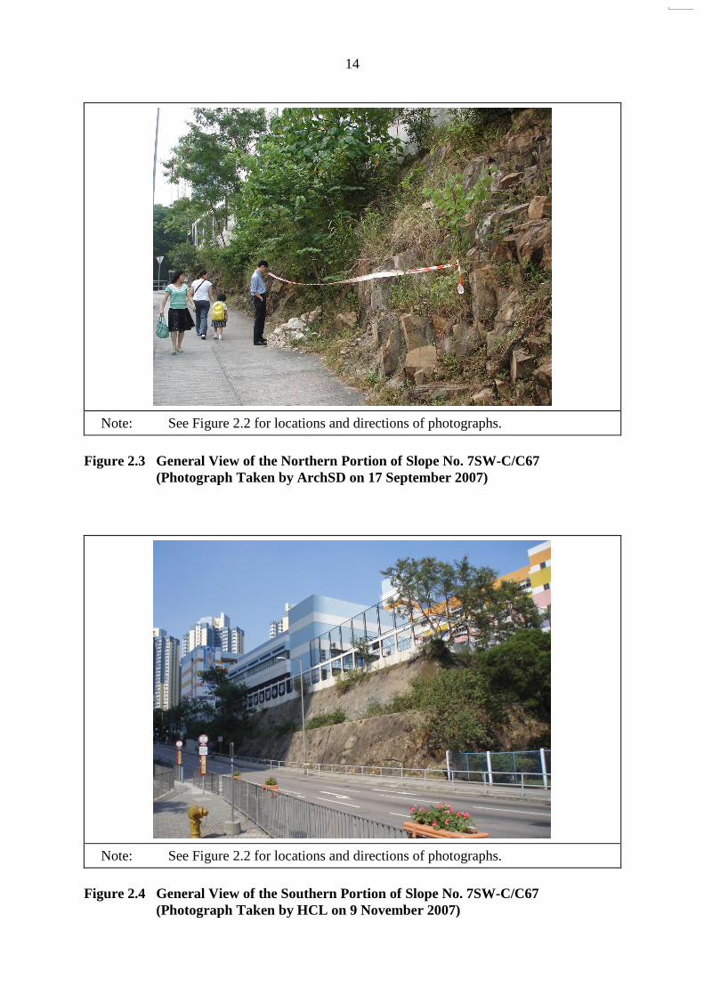
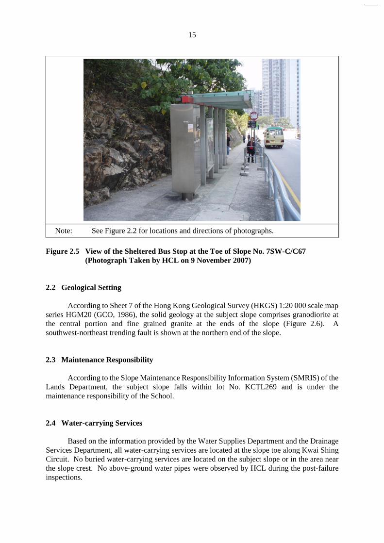
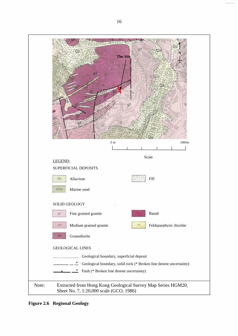
The subject slope is a southwest-facing soil/rock cut of about 125 m long and up to about 11 m high at the southern end (Figure 1.1). It is a roadside slope next to Kwai Shing Circuit, Kwai Chung, which is a three-lane, two-way carriageway with an approximately 1.5 m wide pedestrian pavement along the slope toe. Located on a platform above the slope crest is the Methodist Lee Wai Lee College (hereinafter referred to as “the School”). Another registered cut slope No. 7SW-C/C68 adjoins the subject slope to the south. A site layout plan showing the boundary of the slope, together with the approximate location of the September 2007 rockfall, is presented in Figure 2.1. General views of the slope are shown in Figures 2.2 to 2.4. A sheltered bus stop is located at the middle portion of the slope (Figure 2.5).
The southern portion of the subject slope is approximately 50 m long, comprising a 5 m
high upper batter and a 6 m high lower batter with an intervening berm of 1 m in width. This portion comprises predominantly a soil slope covered with chunam and is inclined at about 55 o. Rock outcrops are present in the lower batter at the southern end.
The northern portion is approximately 75 m long and is predominantly a rock cut with a
single batter (up to about 8 m high), inclined at about 65o. The surface is covered with shrubs and trees.
The surface drainage system on the subject slope comprises a 250 mm wide U-channel
on the berm and two 300 mm wide U-channels with cast-iron covers on the slope crest, as shown in Figure 2.1. Runoff collected in the crest channels is discharged directly to the drainage system of the School, while that collected in the berm channel is discharged to the berm channel of the adjoining slope No. 7SW-C/C68.

Figure 1.1 Location Plan
11
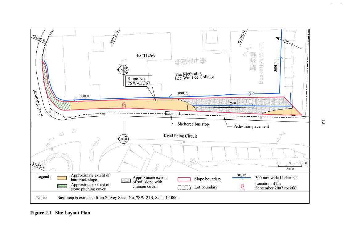
Figure 2.1 Site Layout Plan
12

Figure 2.2 Locations and Directions of Photographs Taken
13
14
Note: See Figure 2.2 for locations and directions of photographs.
Figure 2.3 General View of the Northern Portion of Slope No. 7SW-C/C67
(Photograph Taken by ArchSD on 17 September 2007)
Note: See Figure 2.2 for locations and directions of photographs.
Figure 2.4 General View of the Southern Portion of Slope No. 7SW-C/C67
(Photograph Taken by HCL on 9 November 2007)
15
Note: See Figure 2.2 for locations and directions of photographs.
Figure 2.5 View of the Sheltered Bus Stop at the Toe of Slope No. 7SW-C/C67
(Photograph Taken by HCL on 9 November 2007)
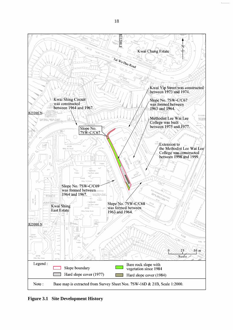
2.2 Geological Setting According to Sheet 7 of the Hong Kong Geological Survey (HKGS) 1:20 000 scale map
series HGM20 (GCO, 1986), the solid geology at the subject slope comprises granodiorite at the central portion and fine grained granite at the ends of the slope (Figure 2.6). A southwest-northeast trending fault is shown at the northern end of the slope.
2.3 Maintenance Responsibility According to the Slope Maintenance Responsibility Information System (SMRIS) of the
Lands Department, the subject slope falls within lot No. KCTL269 and is under the maintenance responsibility of the School.
2.4 Water-carrying Services
Based on the information provided by the Water Supplies Department and the Drainage
Services Department, all water-carrying services are located at the slope toe along Kwai Shing Circuit. No buried water-carrying services are located on the subject slope or in the area near the slope crest. No above-ground water pipes were observed by HCL during the post-failure inspections.
16
Note: Extracted from Hong Kong Geological Survey Map Series HGM20, Sheet No. 7, 1:20,000 scale (GCO, 1986)
Figure 2.6 Regional Geology
LEGEND:
SUPERFICIAL DEPOSITS
Fill
Fine grained granite
SOLID GEOLOGY
GEOLOGICAL LINES
Medium grained granite
Granodiorite
1000m
Alluvium
N
The Site
0 m
Scale
Basalt
Feldsparphyric rhyolite
Geological boundary, superficial deposit Geological boundary, solid rock (* Broken line denote uncertainty)
Fault (* Broken line denote uncertainty)
Marine sand

17
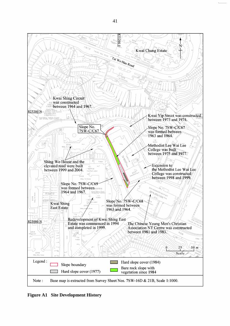
3 Site History and Past Slope Instabilities
3.1 Site History The development history of the site has been established from a review of aerial
photographs and inspection of the available relevant documentary records (Figure 3.1). A detailed account of the aerial photograph interpretation (API) is presented in Appendix A. Salient aspects of the key observations are summarised below.
From the earliest available aerial photographs taken in 1949, the whole area of Kwai
Shing is undeveloped. The subject slope is at the mid-slope of a gentle southwest-facing concave natural hillside below a sub-rounded ridgeline, which trends from northeast to southwest. A ridgeline exists to the northeast and southeast of the subject slope. No drainage line is observed in the vicinity with the subject slope.
By 1963, a newly formed road, early stage of Kwai Shing Circuit, is located below the
subject slope. This road appears to have been formed by cut and fill. By 1964, the subject slope and the adjoining slope No. 7SW-C/C68 had been formed
and the formation of the platform above these slopes commenced. The northern portion of the slope is observed to have an irregular, rugged surface, which suggests this portion is in rock. Also, the smooth appearance of the southern portion indicates that this portion of the slope is in soil.
By 1967, both the formation of platform observed in the 1964 aerial photographs and the
Kwai Shing Circuit in front of the subject slope were completed. By 1972, a berm is visible in the mid-height of the southern portion of the subject slope. In the 1974 aerial photographs, shallow vegetation growth is observed at the southern
portion (a soil cut slope) while a bare surface is noted for the northern portion (a rock cut slope). By 1975, the foundation works for the School above the subject slope crest has
commenced. The construction of the School was completed by 1977. Moreover, the southern portion of the slope is covered by a hard slope surface.
In the 1978 aerial photographs, a rock outcrop is visible at the toe of the middle portion
of the subject slope and a sub-vertical joint set which strikes northeast to southwest is visible within the rock outcrop.
By 1984, hard slope cover has been applied to the southern soil portion and the northern
rock portion was covered with vegetation. In the 1991 aerial photographs, over-growth of vegetation is observed at the southern
portion of the slope, probably indicating inadequate maintenance. In the 1994 aerial photographs, such vegetation appears to have been cleared.
Between 1994 and 2006, little change is observed, other than a general increase in
vegetation density, especially at the location of the 2007 rockfall.
18
Figure 3.1 Site Development History

19
3.2 Past Slope Instabilities
According to the GEO's landslide database, there are no records of any previous
reported landslides on the subject slope and in the adjoining area, before the rockfall incident.
4 Previous Assessments and Slope Maintenance
4.1 Phase 1 Landslide Studies by Binnie & Partners
The subject slope was registered as slope No. 7SW-C/C67 in the 1977/78 Catalogue of
Slopes and was investigated under the Landslide Studies Phase 1 by Binnie & Partners (B&P) for the Geotechnical Control Office (GCO, renamed GEO in 1991) in 1978. According to the Re-Appraisal Report prepared by B&P in January 1978, the condition of the slope was assessed as "fair". Neither signs of distress, nor signs of seepage were recorded in the report. Therefore, no further action was proposed.
4.2 Stage 1 Study by GEO
In September 1992, a Stage 1 Study of the subject slope was carried out by the Planning
Division of the GEO. According to the study report, the slope surface was partly covered by vegetation and appeared to be in a good condition. No further action was recommended.
4.3 SIFT and SIRST Studies
In December 1994, under the study entitled "Systematic Inspection of Features in the
Territory" (SIFT) initiated by the GEO, the subject slope was designated as being of SIFT Class 'C1' (i.e. cut slopes that have been formed, or substantially modified before 30 June 1978).
In December 1999, the subject slope was inspected by GEO's consultants as part of the
study entitled "Systematic Identification and Registration of Slopes in the Territory" (SIRST). According to the inspection records, the slope face was assessed as "fair" and its consequence-to-life category was classified as "1".
4.4 LPM Stage 2 Study by Scott Wilson Limited
The subject slope No. 7SW-C/C67 was included in the LPM Programme for safety
screening study under Agreement No. CE10/2003 (GE), based on a recommendation by the consultant, Scott Wilson Limited (SWL), on 30 December 2004. The consultancy agreement was administered by the Slope Safety Division of the GEO. A draft Stage 2 Study report was submitted to the Mainland West Division of the GEO on 15 June 2005 and no further action was recommended in the report.
At the time of the 12 September 2007 rockfall, the Stage 2 Study was on-going. There
were discussions amongst SWL, the Slope Safety Division and the Mainland West Division of

20
the GEO on safety and maintenance concern in respect of the rock cut where the rockfall occurred. Following the rockfall, SWL re-assessed the stability of the slope and finalised the Stage 2 Report, which recommends that a Type 3 Advisory Letter be served to the owner of slope No. 7SW-C/C67. On 26 November 2007, a Type 3 Advisory Letter to the incorporated owners of the School was issued by the Mainland West Division. The school owners were recommended to carry out repair and maintenance works, including clearing undesirable vegetation, scaling off loose rock blocks, fixing wire mesh onto the rock face and repairing damaged chunam cover.
5 The 12 September 2007 Rockfall and Post-failure Observations
5.1 Description of the Incident
The rockfall occurred on slope No. 7SW-C/C67 at Kwai Shing Circuit, Kwai Chung,
Kowloon and the incident was reported by the Buildings Department to the GEO on 13 September 2007 at 5:00 p.m. According to the incident report No. 2007/09/0066, the incident might have taken place on 12 September 2007 following light rainfall. However, the exact timing of the incident was not known.
The incident involved the detachment of rock blocks (approximately 0.5 m3 in volume)
from the subject slope. The source area was about 2.3 m by 1.8 m of 0.1 m in depth as measured on site and was located in the northern middle portion of the slope and 2.2 m above the toe (Figures 5.1 & 5.2). The rockfall debris was deposited on the edge of the pedestrian pavement at the slope toe (Figure 5.3). No casualties were reported and no closure of the pedestrian pavement was implemented as a result of the incident.
5.2 Post-failure Observations of the Rockfall Site
HCL first inspected the site of the rockfall on 9 November 2007 at about 9:30 a.m., by
which time most of the debris had been removed. During the inspection, the weather was dry. Remedial works in the form of a concrete buttress was in progress at the source area of the rockfall.
HCL subsequently visited the site several times between 9 November 2007 and 30 April
2008. The source area of the rockfall was observed to be on a rock slope face generally dipping at about 65º/250º. It comprises pinkish grey, moderately strong, moderately decomposed, fine- to medium-grained granite, with closely to medium spaced joints (Figure 5.2). A sliding joint plane (dipping at about 65o/243o) and a back-release joint plane (dipping at about 77o/135o) were identified at the scar. On these release planes, black and dark reddish brown stains were observed, which were possibly manganese and iron oxides. Such staining indicates water migration, weathering and possible opening of the rock joints prior to the detachment of the rock block in the 2007 incident. Tree roots of up to about 40 mm diameter were also observed growing on the sliding joint plane (Figures 5.2, 5.3 & 5.4). During the inspections, no water seepage was noted at the exposed rockfall source area.
About 0.7 m to the north just above the rockfall source area, a tree with a main trunk of
about 100 mm in diameter was growing on the rock surface (Figure 5.5). Its roots of about
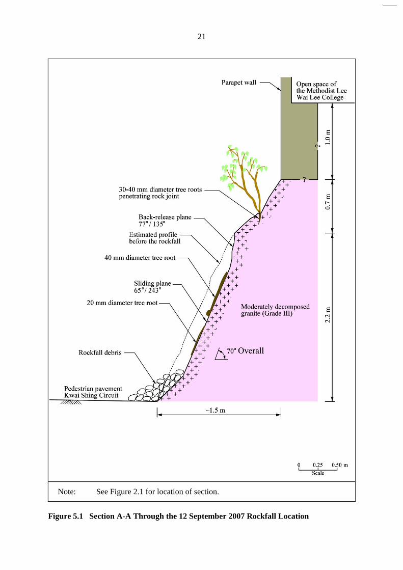
21
Note: See Figure 2.1 for location of section.
Figure 5.1 Section A-A Through the 12 September 2007 Rockfall Location

22
40 mm diameter tree root
Potential sliding plane = 65o/243o
Rebars and relief drains for a proposed concrete buttress
after the rockfall Potential back-release plane = 77o/135o
Source area
Note: See Figure 2.2 for locations and directions of photographs.
Figure 5.2 View of the Source Area of the 12 September 2007 Rockfall
(Photograph Taken by HCL on 9 November 2007)
Note: See Figure 2.2 for locations and directions of photographs.
Figure 5.3 View of the Detached Rock Blocks from the 12 September 2007 Rockfall
(Photograph Taken by ArchSD on 17 September 2007)
23
Note: See Figure 2.2 for locations and directions of photographs.
Figure 5.4 Close-up View of the Source Area of the 12 September 2007 Rockfall
(Photograph Taken by HCL on 9 November 2007)
Note: See Figure 2.2 for locations and directions of photographs.
Figure 5.5 Tree Root Penetrating Rock Joint above Failure Scar
(Photograph Taken by HCL on 9 November 2007)
Potential sliding plane = 65o/243o
Rebars and relief drains for the proposed concrete buttress
24
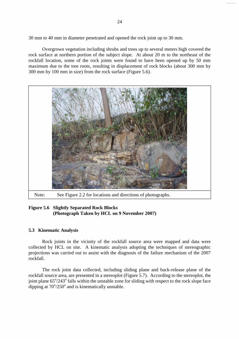
30 mm to 40 mm in diameter penetrated and opened the rock joint up to 30 mm. Overgrown vegetation including shrubs and trees up to several meters high covered the
rock surface at northern portion of the subject slope. At about 20 m to the northeast of the rockfall location, some of the rock joints were found to have been opened up by 50 mm maximum due to the tree roots, resulting in displacement of rock blocks (about 300 mm by 300 mm by 100 mm in size) from the rock surface (Figure 5.6).
Note: See Figure 2.2 for locations and directions of photographs.
Figure 5.6 Slightly Separated Rock Blocks
(Photograph Taken by HCL on 9 November 2007)
5.3 Kinematic Analysis
Rock joints in the vicinity of the rockfall source area were mapped and data were
collected by HCL on site. A kinematic analysis adopting the techniques of stereographic projections was carried out to assist with the diagnosis of the failure mechanism of the 2007 rockfall.
The rock joint data collected, including sliding plane and back-release plane of the
rockfall source area, are presented in a stereoplot (Figure 5.7). According to the stereoplot, the joint plane 65o/243o falls within the unstable zone for sliding with respect to the rock slope face dipping at 70o/250o and is kinematically unstable.
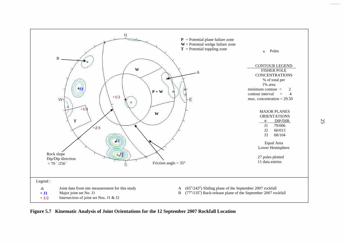
Figure 5.7 Kinematic Analysis of Joint Orientations for the 12 September 2007 Rockfall Location
25
+2/3
+
J1
T
W
P + W
W
Friction angle = 35°
B
Rock slope Dip/Dip direction = 70 ゚/250 ゚
A
+
+
J2
J3
+1/3
+1/2
P = Potential plane failure zone W = Potential wedge failure zone T = Potential toppling zone
CONTOUR LEGEND FISHER POLE
CONCENTRATIONS % of total per
1% area minimum contour = 2 contour interval = 4 max. concentration = 29.50
MAJOR PLANES ORIENTATIONS # DIP/DIR.
J1 79/006 J2 60/013 J3 68/104
Equal Area
Lower Hemisphere
27 poles plotted 11 data entries
Poles
Legend :
Joint data from site measurement for this study A (65o/243o) Sliding plane of the September 2007 rockfall Major joint set No. J1 B (77o/135o) Back-release plane of the September 2007 rockfall Intersection of joint set Nos. J1 & J2
+ J1
+ 1/2

26
6 Analysis of Rainfall Records
Rainfall data were obtained from the nearest GEO automatic raingauge (No. N03),
which is located at the Tsuen Wan Treatment Works, Shing Mun Road, about 1 km to the north of the subject slope (Figure 1.1). This raingauge records and transmits rainfall data at 5-minute intervals, via a telephone line to the Hong Kong Observatory and the GEO.
Based on limited information available, the rockfall might have occurred during rainfall
at about 1:00 a.m. on 12 September 2007. The daily rainfall for the period of 31 days before the incident and the hourly rainfall between 11 and 12 September 2007 are presented in Figure 6.1. The record of the daily rainfall shows that relatively light rainfall occurred during the 12 hours preceding the rockfall, with the maximum 1-hour rolling rainfall of about 1.5 mm between 11:00 p.m. on 11 September 2007 and 1:00 a.m. on 12 September 2007.
The return period for the rainfall recorded at Raingauge No. N03 preceding the rockfall
was estimated based on the historical rainfall data at the Hong Kong Observatory (Lam & Leung, 1994). The maximum rolling rainfall for various durations was derived and is given in Table 6.1. The result shows that the return period of the rainfall on 12 September 2007 is less than 2 years. The return period was also assessed based on the statistical parameters derived by Evans & Yu (2001) for rainfall data recorded by Raingauge No. N03. The return periods estimated using data of Lam & Leung (1994) and Evans & Yu (2001) respectively are very similar in this case (Table 6.1).
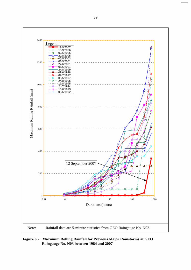
A comparison of the maximum rolling rainfall on 12 September 2007 with that of the
past major rainstorms recorded by Raingauge No. N03 is presented in Figure 6.2. The rainstorm of 12 September 2007 was insignificant. 7 Discussion
The 12 September 2007 rockfall, which involved the detachment of several small rock
blocks (about 0.5 m3 in total) from a non-engineered, soil/rock cut slope. At the 2007 rockfall source area, much of the bare rock surface was covered with
vegetation and tree roots (Figure 2.3). Several small rock blocks were identified to have separated from the rock mass (Figure 5.6), and these appeared to be the result of the wedging action of the tree roots on the rock joints. At the rockfall source area, a tree root of about 40 mm in diameter was present on the sliding joint plane (Figures 5.2 & 5.4). The wedging effects of tree roots might have opened up existing joints in the rock, resulting in progressive deterioration of the rock mass. Moreover, the kinematic analysis carried out as part of this review indicates that the release planes in the area of the 2007 rockfall are adversely orientated. The wedging effect of tree roots, coupled with the presence of adverse joints, might be a key contributory factor towards the rockfall. In addition, the possible build-up of transient water pressure due to the rainfall on 12 September 2007 within the joint planes might have triggered the incident.
This incident highlights the importance of regular maintenance of rock slopes,
especially removal of undesirable vegetation and potentially loose rock blocks that are prone to

27
Table 6.1 Maximum Rolling Rainfall at GEO Raingauge No. N03 for Selected Durations
Preceding the Rockfall on 12 September 2007 and Estimated Return Periods
Duration Maximum
Rolling Rainfall (mm)
End of Period (Hours)
(see Note 4)
Estimated Return Period
(Years) (see Note 3)
A B
5 minutes 1.0 01:00 hours on 12 September 2007 1 1
15 minutes 1.5 01:00 hours on 12 September 2007 1 1
1 hour 1.5 01:00 hours on 12 September 2007 1 1
2 hours 3.0 01:00 hours on 12 September 2007 1 1
4 hours 3.0 01:00 hours on 12 September 2007 1 1
12 hours 3.0 01:00 hours on 12 September 2007 1 1
24 hours 3.0 01:00 hours on 12 September 2007 1 1
2 days 3.0 01:00 hours on 12 September 2007 1 1
4 days 3.0 01:00 hours on 12 September 2007 1 1
7 days 12.0 11:05 hours on 10 September 2007 1 1
15 days 59.0 08:15 hours on 11 September 2007 1 < 2
31 days 428.5 00:10 hours on 10 September 2007 < 2 < 2
Notes: (1) Maximum rolling rainfall was calculated from 5-minute rainfall data.
(2) The nearest GEO raingauge to the landslide site is Raingauge No. N03 located at Tsuen Wan Treatment Works, Shing Mun Road at about 1000 m to the northeast of the landslide site.
(3) Return periods were derived from Table 3 of Lam & Leung (1994) (Column A refers) and using data of Raingauge No. N03 from Evans & Yu (2001) (Column B refers). The return periods obtained by data of Lam & Leung (1994) and Evans & Yu (2001) do not show a significant difference.
(4) For the purpose of rainfall analysis, the landslide was assumed to occur at 01:00 hours on 12 September 2007.

28
Figure 6.1 Daily and Hourly Rainfall Recorded at GEO Raingauge No. N03
0
10
20
30
40
50
60
70
80
90
13 15 17 19 21 23 25 27 29 31 2 4 6 8 10 12 14 16 18
August 2007
(a) Daily Rainfall Recorded between 13 August and 18 September 2007
September 2007
Assumed date of the landslide
(12 September 2007)
27 mm of rainfall recorded in the
15-day period before the landslide
334.5 mm of rainfall recorded in the 31-day period before the landslide
Dail
y R
ain
fall
(m
m)
0.0
0.5
1.0
1.5
2.0
01:00 05:00 09:00 13:00 17:00 21:00 01:00 05:00
(b) Hourly Rainfall Recorded between 01:00 hour on 11 September and
06:00 hour on 12 September 2007
Landslide was assumed to be
occurred at about 01:00 a.m. on
12 September 2007
3 mm of rainfall recorded in the 24-hour period before the landslide
3 mm of rainfall recorded in the 12-
hour period before the landslide
11 September 2007 12 September 2007
Ho
url
y R
ain
fall
(m
m)
29
Figure 6.2 Maximum Rolling Rainfall for Previous Major Rainstorms at GEO
Raingauge No. N03 between 1984 and 2007
Note: Rainfall data are 5-minute statistics from GEO Raingauge No. N03.
0
200
400
600
800
1000
1200
1400
0.01 0.1 1 10 100 1000
Durations (hours)
Max
imu
m R
oll
ing
Rai
nfa
ll (
mm
)
12/9/200713/9/200602/6/200620/8/200505/5/200301/9/200127/6/200101/6/200124/8/199909/6/199802/7/199708/5/199724/8/199513/8/199524/7/199416/6/199308/5/1992
Legend:
12 September 2007

30
deterioration and undue movement caused by tree root growth. The maintenance works may include fixing of wire mesh on the rock face, especially where the rock is highly fractured, to prevent loose rock blocks from falling directly towards critical facilities in close proximity.
Based on the field inspections, no obvious signs of incipient large-scale instability were observed during the course of this study.
8 References
Evans, N.C. & Yu, Y.F. (2001). Regional Variation in Extreme Rainfall Values (GEO Report
No. 115). Geotechnical Engineering Office, Hong Kong, 81 p. Geotechnical Control Office (1986). Hong Kong and Kowloon: Solid and superficial geology.
Hong Kong Geological Survey, Map Series HGM 20, Sheet 7, 1:20 000 Scale. Geotechnical Control Office, Hong Kong.
Lam, C.C. & Leung, Y.K. (1994). Extreme Rainfall Statistics and Design Rainstorm Profiles at
Selection Locations in Hong Kong. Technical Note No. 86, Royal Observatory, Hong Kong, 89 p.
Scott Wilson Limited (2007). Feature No. 7SW-C/C67, KCTL269, West of Methodist Lee Wai
Lee College, Kwai Shing. Stage 2 Study Report No. S2R 64/2005. Report prepared for the Geotechnical Engineering Office, 113 p.

31
Appendix A
Aerial Photograph Interpretation

32
A.1 Detailed Observations
The following report comprises the detailed observations made from the examination
of aerial photographs taken between 1949 and 2006. A list of aerial photographs examined in this study is presented in Table A1 and the main observations of the API are shown in Figure A1 and Figure A2.
Year Observations
1949
High resolution stereo pairs. Topographically, the location of slope No. 7SW-C/C67 (thereafter the subject slope) affected by the September 2007 Rockfall is at the mid-slope of a gentle southwest-facing concave natural hillside below a sub-rounded ridgeline which trends from northeast to southwest with a maximum elevation of about 100 m. The subject hillside is generally overgrown with short grass and shrubs. Slope No. 7SW-C/C67 is not yet formed. Severe surface erosions, sheet and gully erosion, appears at the ridge line and the spur line to the northeast and southeast of the subject slope location respectively. A possible minor landslide with an estimated volume of about 50 m3 is observed at the relatively steeper slope at about 80 m to the west of the subject slope. An ephemeral drainage line which runs from north to south is located at the toe of the subject hillside. A footpath which connects the northern hilltop and the lower reaches is formed across the mid-slope of the subject hillside. The study area is largely undeveloped.
1954 High altitude and low resolution stereo pairs. It is difficult to observe in details due to the poor resolution of the photographs. However, there does not seem to have any slope cutting work being taken place at the subject slope location. Slope No. 7SW-C/C67 is not yet formed and the study area is still undeveloped.
1963 Low altitude and high resolution stereo pairs.
Development of Kwai Chung Estate is commenced to the north of the subject slope. A service reservoir is constructed for the development at about 400 m to the west of the study area. A newly formed road, early stage of Kwai Shing Circuit, which connects to the service reservoir is also built cutting across the subject hillside. The road section along the subject hillside is formed by slope cutting and filling the hollow located at the northeastern side below the subject slope.

33
Remnant of previous agricultural terraces appears at the terrain above the subject cut slope. Couples of cottages and agricultural activities are apparent at the sideslopes along the valley floor below the subject hillside. Sheet and gully erosion are still visible at the spur above the southern portion of the subject slope. Slope No. 7SW-C/C67 and the College above are not yet constructed.
1964 Low altitude, high resolution single photograph. Extensive excavation probably for the construction of Kwai Shing East Estate is commenced at the study area. Previous ridges have been levelled and valleys have been filled up. The alignment of the early stage of Kwai Shing Circuit is straightened. The spur identified above the southern portion of the subject slope in 1963 is trimmed and levelled forming a platform at the top. Slope No. 7SW-C/C67 is formed in association with the platform. The height of the subject cut slope increases from its northern end to a maximum height of approximate 8 to 9 m towards its southern end. The subject slope generally appears to be inclined as 60° to 70°. The irregular rugged slope surface at the northern portion of the slope suggesting it comprises rocky slope. While the smooth appearance of the southern portion of the subject slope surface indicating that is in soil. Surface drainage channel is visible above the crest of the southern portion of the subject slope. Slope No. 7SW-C/C68 adjoining the subject slope in the southern end is also formed. Both the subject slope and slope No. 7SW-C/C68 are in bare condition without any hard slope surface protection.
1967 Low altitude, high resolution single photograph.
No observable significant change to the subject slope since 1964. Re-alignment of Kwai Shing Circuit in front of the subject slope toe is completed. Site formation of the Methodist Lee Wai Lee College is also finished above the subject slope crest. Slope No. 7SW-C/C69 is formed at the foothill below the subject slope.
1969 Low altitude, high resolution single photograph. Construction of the Methodist Lee Wai Lee College is not yet commenced. Sporadic vegetation growth is visible at the levelled platform above the subject slope. No sign of distress is identified at or in the vicinity of the subject slope. Construction of Kwai Shing East Estate to the west of the subject slope is

34
commenced.
1972 High altitude, single photograph. The study area is largely developed. A significant increase in the population and resident blocks are observed in the study area. Residential blocks of Kwai Shing East Estate are erected at the previous valley below the subject slope. A berm of about 40 m long in the mid-height of the southern portion of the subject cut slope is visible and the surface of the cut slope is in bare condition. Slope No. 7SW-C/C67 is formed resemble the present day layout. Site formation of Daughters of Mary Help of Christians Sui Ming Catholic Secondary School is also under construction immediate to the east of the site of Methodist Lee Wai Lee College.
1973 High altitude stereo pairs. No observable significant change to the subject slope is apparent since 1972. Surface of the cut slope is still in bare condition. Site formation work of the platform above the subject slope is in progress. Kwai Yip Street, to the northeast of the subject slope, is also under construction. Construction of the Daughters of Mary Help of Christians Sui Ming Catholic Secondary School to the east of the subject slope is in progress.
1974 High altitude stereo pairs.
Shallow vegetation growth is observed at the southern portion of the subject slope surface. While the northern portion of the cut slope is still appeared as bare surface. Sporadic shallow grass is grown at the platform above the subject slope crest. Foundation of the Methodist Lee Wai Lee College is not commenced. Construction of Kwai Yip Street is completed forming an access road between Kwai Shing Circuit and the newly formed Daughters of Mary Help of Christians Sui Ming Catholic Secondary School.
1975 High altitude stereo pairs. Foundation work of the Methodist Lee Wai Lee College above the subject slope crest is commenced. No observable change to the subject slope is apparent since 1973.
35
1977 Low altitude and high resolution stereo pairs. Construction of the Methodist Lee Wai Lee College is completed. A hard slope surface has been implemented to the southern portion of the subject slope. While vegetation surface is observed at the northern portion of subject slope.
1978 Low altitude and high resolution stereo pairs. A rock outcrop is visible at the middle portion of the subject slope toe and a sub-vertical joint set which strikes northeast to southwest is visible within the rock outcrop. An open space for car park is formed in front of the slope No. 7SW-C/C68. A new hard slope surface is also implemented at the southern portion of the slope No. 7SW-C/C69 which is located below the subject slope.
1979 High altitude stereo pairs. There is no observable change to the subject slope. No sign of distress is also identified in the vicinity of the slope.
1981 Low altitude and high resolution stereo pairs.
There is no observable change to the subject slope. The Chinese Young Men’s Christian Association NT Centre is under construction in front of the slope No. 7SW-C/C68.
1982 Low altitude and high resolution single photograph. No observable significant change to the subject slope. Part of the slope is obscured by the shadow of the Methodist Lee Wai Lee College.
1983 High altitude and high resolution stereo pairs. Neither observable significant change nor sign of distress are identified in the vicinity the subject slope. Construction of the Chinese Young Men’s Christian Association NT Centre
is completed.
1984 Low altitude and high resolution stereo pairs. A 20 m by 2 m new hard slope surface has been implemented at the upper batter of the southern portion of the subject slope. On the other hand, vegetation starts growing at the northern portion of the subject slope.

36
1986 High altitude and high resolution stereo pairs. There appears a slight increase in vegetation density at the northern portion of the subject slope. A new extension block of the Chinese Young Men’s Christian Association
NT Centre is under construction in front of the Slope 7SW-C/C68.
1988 Low altitude and high resolution single photograph. Subject slope is obscured by the Methodist Lee Wai Lee College.
1990 Low altitude and high resolution single photograph.
Subject slope is obscured by the Methodist Lee Wai Lee College. The new extension block of the Chinese Young Men’s Christian
Association NT Centre is completed in front of the slope No. 7SW-C/C68.
1991 Low altitude and high resolution stereo pairs. Subject slope is partly obscured by the Methodist Lee Wai Lee College. Vegetation growth is observed at the southern portion of the subject slope surface, indicating inadequate maintenance.
1992 Low altitude and high resolution stereo pairs. No observable significant change to the subject slope. Surface of the subject slope is still covered with a thin layer of vegetation.
1993 Low altitude and high resolution stereo pairs. No significant change to the subject slope since 1992.
1994 Low altitude and high resolution single photograph. Vegetation clearance appeared to have been carried out at the southern portion of the subject slope. Kwai Shing East Estate opposite to the subject slope is under redevelopment. Previous residential blocks are being demolished.
1995 Low altitude and high resolution stereo pairs. First year of colour photographs. No significant change to the subject slope since 1994. Previous residential blocks of Kwai Shing East Estate are demolished leaving a levelled platform.
37
1996 Low altitude and high resolution stereo pairs. No observable change to the subject slope. New residential blocks of Kwai Shing East Estate are under construction.
1997 High altitude and hazy stereo pairs. No significant change to the subject slope since 1996. Redevelopment of Kwai Shing East Estate is still taking place.
1998 Low altitude and high resolution stereo pairs.
Sporadic thin vegetation is noted on the subject slope surface. The new residential blocks of Kwai Shing East Estate are almost completed.
1999 Low altitude and high resolution stereo pairs. No observable significant change to the subject slope was apparent. Redevelopment of Shing Yat House and Shing Keung House are completed. An elevated road which connected between Kwai Shing Circuit and Kwai Shing East Shopping Centre was under construction opposite to the northern portion of the subject slope.
2000 Low altitude and high resolution stereo pairs. Southern portion of the subject slope is entirely obscured by shadow. No sign of distress is observed at the northern portion of the slope. Shing Wo House to the west of the subject slope is under construction.
2001 Low altitude and high resolution stereo pairs. No significant change to the subject slope since 2000. Shing Wo House and the elevated road are still under construction.
2003 Low altitude, single photograph. No significant change to the subject slope since 2002.
2004 Low altitude, single photograph. Subject slope is obscured by shadow. Construction of Shing Wo House and the elevated road to the west of the subject slope is completed.
2005 Low altitude, infra-red stereo pairs. Sporadic young trees are clearly visible at the northern portion of the subject slope. Hard slope surface cover, possibly shotcrete, is also evident

38
at the southern portion of the subject slope.
2006 Low altitude, high resolution stereo pairs. The trees at the northern portion of the subject slope appears to have been growth over the crest of the slope. The rest portion of the slope is obscured by shadow.
39
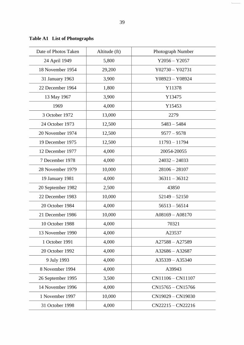
Table A1 List of Photographs
Date of Photos Taken Altitude (ft) Photograph Number
24 April 1949 5,800 Y2056 – Y2057
18 November 1954 29,200 Y02730 – Y02731
31 January 1963 3,900 Y08923 – Y08924
22 December 1964 1,800 Y11378
13 May 1967 3,900 Y13475
1969 4,000 Y15453
3 October 1972 13,000 2279
24 October 1973 12,500 5483 – 5484
20 November 1974 12,500 9577 – 9578
19 December 1975 12,500 11793 – 11794
12 December 1977 4,000 20054-20055
7 December 1978 4,000 24032 – 24033
28 November 1979 10,000 28106 – 28107
19 January 1981 4,000 36311 – 36312
20 September 1982 2,500 43850
22 December 1983 10,000 52149 – 52150
20 October 1984 4,000 56513 – 56514
21 December 1986 10,000 A08169 – A08170
10 October 1988 4,000 70321
13 November 1990 4,000 A23537
1 October 1991 4,000 A27588 – A27589
20 October 1992 4,000 A32686 – A32687
9 July 1993 4,000 A35339 – A35340
8 November 1994 4,000 A39943
26 September 1995 3,500 CN11106 – CN11107
14 November 1996 4,000 CN15765 – CN15766
1 November 1997 10,000 CN19029 – CN19030
31 October 1998 4,000 CN22215 – CN22216
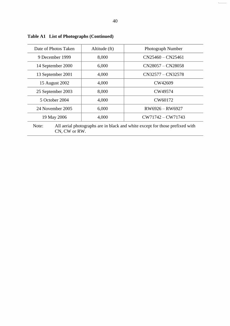
40
Table A1 List of Photographs (Continued)
Date of Photos Taken Altitude (ft) Photograph Number
9 December 1999 8,000 CN25460 – CN25461
14 September 2000 6,000 CN28057 – CN28058
13 September 2001 4,000 CN32577 – CN32578
15 August 2002 4,000 CW42609
25 September 2003 8,000 CW49574
5 October 2004 4,000 CW60172
24 November 2005 6,000 RW6926 – RW6927
19 May 2006 4,000 CW71742 – CW71743
Note: All aerial photographs are in black and white except for those prefixed with CN, CW or RW.
41
Figure A1 Site Development History
42
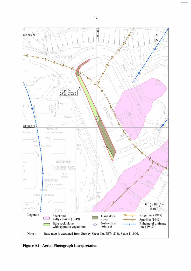
Figure A2 Aerial Photograph Interpretation

43
Figure A3 Interpretation of 1949 Aerial Photograph
(Photograph Y2056 taken on 24 April 1949)
Approximate location of slope No. 7SW-C/C67
Possible minor landslide
Legend:
Ephemeral drainage line
Spurline
Possible landslide scar
N
Ridgeline
Sheet erosion
Footpath
Sheet and gully erosion

44
Figure A4 Interpretation of 1963 Aerial Photograph
(Photograph Y08923 taken on 31 January 1963)
Development of Kwai Chung Estate was commenced to the north of the subject slope.
Location of slope No. 7SW-C/C67
Sheet and gully erosion were still visible at the spur above the southern portion of the subject slope.
Remnant of previous agricultural terraces
Couples of cottages and agricultural activities were apparent at the sideslopes along the valley floor below the subject hillside.
Service reservoir
A newly formed road, early stage of Kwai Shing Circuit, which connected to the service reservoir was also built cutting across the subject hillside. The road section along the subject hillside was formed by slope cutting and filling the hollow located at the northeastern side below the subject slope.
N
45
Figure A5 Interpretation of 1964 Aerial Photograph
(Photograph Y11378 taken on 22 December 1964)
The spur identified above the southern portion of the subject slope in 1963 was trimmed and leveled forming a platform at the top.
Slope No. 7SW-C/C68
The subject slope generally appeared to be inclined as 60° to 70°. The irregular rugged slope surface at the northern portion of the slope suggesting it comprised of rocky slope. While the smoothly appearance of the southern portion of the subject slope surface indicating it was cutting across a soil profile.
The alignment of the early stage of Kwai Shing Circuit was straightened.
Extensive excavation probably for the construction of Kwai Shing East Estate was commenced at the study area.
N
Surface drainage channel
Slope No. 7SW-C/C67

46
Figure A6 Interpretation of 1977 Aerial Photograph
(Photograph 20055 taken on 12 December 1977)
Construction of the Methodist Lee Wai Lee College was completed.
A hard slope surface has been implemented to the southern portion of the subject slope. While vegetation surface was observed at the northern portion of subject slope.
Construction of Kwai Yip Street was completed forming an access road between Kwai Shing Circuit and the newly formed Daughters of Mary Help of Christians Sui Ming Catholic Secondary School.
N
Slope No. 7SW-C/C67

47
Figure A7 Interpretation of 1978 Aerial Photograph
(Photograph 24033 taken on 7 December 1978)
An open space for car park was formed in front of the slope No. 7SW-C/C68.
Rock outcrop was visible at the middle portion of the Slope 7SW-C/C67 slope toe. A sub-vertical joint set which strikes northeast to southwest was visible within the rock outcrop.
A new hard slope surface was also implemented at the southern portion of the slope No. 7SW-C/C69 which was located below the subject slope.
N
Slope No. 7SW-C/C67
Slope No. 7SW-C/C68
48
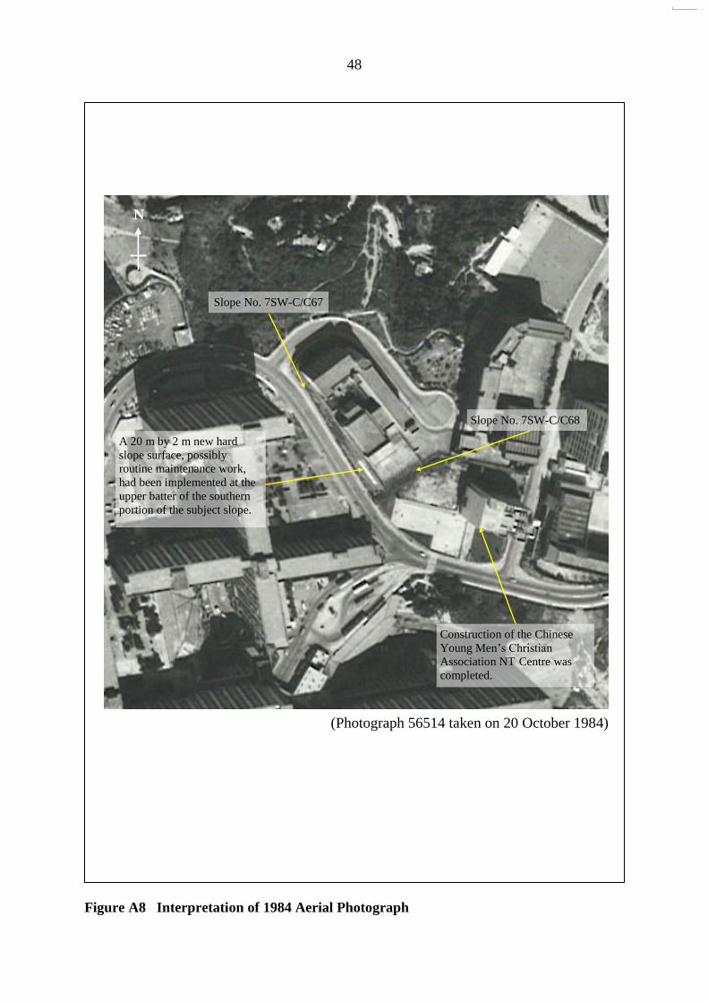
Figure A8 Interpretation of 1984 Aerial Photograph
(Photograph 56514 taken on 20 October 1984)
Construction of the Chinese Young Men’s Christian
Association NT Centre was completed.
A 20 m by 2 m new hard slope surface, possibly routine maintenance work, had been implemented at the upper batter of the southern portion of the subject slope.
N
Slope No. 7SW-C/C67
Slope No. 7SW-C/C68

49
Figure A9 Interpretation of 2005 Aerial Photograph
(Photograph RW6926 taken on 24 November 2005)
Sporadic young trees were clearly visible at the northern portion of the subject slope.
N
Slope No. 7SW-C/C67
Slope No. 7SW-C/C68
Hard slope surface cover, possibly shotcrete, was also evident at the southern portion of the subject slope.

GEO PUBLICATIONS AND ORDERING INFORMATION土力工程處刊物及訂購資料
A selected list of major GEO publications is given in the next page. An up-to-date full list of GEO publications can be found at the CEDD Website http://www.cedd.gov.hk on the Internet under “Publications”. Abstracts for the documents can also be found at the same website. Technical Guidance Notes are published on the CEDD Website from time to time to provide updates to GEO publications prior to their next revision.
部份土力工程處的主要刊物目錄刊載於下頁。而詳盡及最新的
土力工程處刊物目錄,則登載於土木工程拓展署的互聯網網頁
http://www.cedd.gov.hk 的“刊物”版面之內。刊物的摘要及更新
刊物內容的工程技術指引,亦可在這個網址找到。
Copies of GEO publications (except geological maps and other publications which are free of charge) can be purchased either by:
讀者可採用以下方法購買土力工程處刊物(地質圖及免費刊物除外):
Writing toPublications Sales Section,Information Services Department,Room 402, 4th Floor, Murray Building,Garden Road, Central, Hong Kong.Fax: (852) 2598 7482
書面訂購
香港中環花園道
美利大廈4樓402室
政府新聞處
刊物銷售組
傳真: (852) 2598 7482
or- Calling the Publications Sales Section of Information Services Department (ISD) at (852) 2537 1910- Visiting the online Government Bookstore at http:// www.bookstore.gov.hk- Downloading the order form from the ISD website at http://www.isd.gov.hk and submitting the order online or by fax to (852) 2523 7195- Placing order with ISD by e-mail at [email protected]
或
- 致電政府新聞處刊物銷售小組訂購 (電話:(852) 2537 1910)- 進入網上「政府書店」選購,網址為
http://www.bookstore.gov.hk- 透過政府新聞處的網站 (http://www.isd.gov.hk) 於網上遞交
訂購表格,或將表格傳真至刊物銷售小組 (傳真:(852) 2523 7195)- 以電郵方式訂購 (電郵地址:[email protected])
1:100 000, 1:20 000 and 1:5 000 geological maps can be purchased from:
讀者可於下列地點購買1:100 000、1:20 000及1:5 000地質圖:
Map Publications Centre/HK,Survey & Mapping Office, Lands Department,23th Floor, North Point Government Offices,333 Java Road, North Point, Hong Kong.Tel: (852) 2231 3187Fax: (852) 2116 0774
香港北角渣華道333號
北角政府合署23樓
地政總署測繪處
電話: (852) 2231 3187傳真: (852) 2116 0774
Requests for copies of Geological Survey Sheet Reports and other publications which are free of charge should be directed to:
如欲索取地質調查報告及其他免費刊物,請致函:
For Geological Survey Sheet Reports which are free of charge:Chief Geotechnical Engineer/Planning,(Attn: Hong Kong Geological Survey Section)Geotechnical Engineering Office,Civil Engineering and Development Department,Civil Engineering and Development Building,101 Princess Margaret Road,Homantin, Kowloon, Hong Kong.Tel: (852) 2762 5380Fax: (852) 2714 0247E-mail: [email protected]
免費地質調查報告:
香港九龍何文田公主道101號
土木工程拓展署大樓
土木工程拓展署
土力工程處
規劃部總土力工程師
(請交:香港地質調查組)電話: (852) 2762 5380傳真: (852) 2714 0247電子郵件: [email protected]
For other publications which are free of charge:Chief Geotechnical Engineer/Standards and Testing,Geotechnical Engineering Office,Civil Engineering and Development Department,Civil Engineering and Development Building,101 Princess Margaret Road,Homantin, Kowloon, Hong Kong.Tel: (852) 2762 5346Fax: (852) 2714 0275E-mail: thomashui @cedd.gov.hk
其他免費刊物:
香港九龍何文田公主道101號
土木工程拓展署大樓
土木工程拓展署
土力工程處
標準及測試部總土力工程師
電話: (852) 2762 5346傳真: (852) 2714 0275電子郵件: [email protected]

MAJOR GEOTECHNICAL ENGINEERING OFFICE PUBLICATIONS土力工程處之主要刊物
GEOTECHNICAL MANUALS
Geotechnical Manual for Slopes, 2nd Edition (1984), 302 p. (English Version), (Reprinted, 2011).斜坡岩土工程手冊(1998),308頁(1984年英文版的中文譯本)。Highway Slope Manual (2000), 114 p.
GEOGUIDES
Geoguide 1 Guide to Retaining Wall Design, 2nd Edition (1993), 258 p. (Reprinted, 2007).Geoguide 2 Guide to Site Investigation (1987), 359 p. (Reprinted, 2000).Geoguide 3 Guide to Rock and Soil Descriptions (1988), 186 p. (Reprinted, 2000).Geoguide 4 Guide to Cavern Engineering (1992), 148 p. (Reprinted, 1998).Geoguide 5 Guide to Slope Maintenance, 3rd Edition (2003), 132 p. (English Version).岩土指南第五冊 斜坡維修指南,第三版(2003),120頁(中文版)。Geoguide 6 Guide to Reinforced Fill Structure and Slope Design (2002), 236 p.Geoguide 7 Guide to Soil Nail Design and Construction (2008), 97 p.
GEOSPECS
Geospec 1 Model Specification for Prestressed Ground Anchors, 2nd Edition (1989), 164 p. (Reprinted, 1997).
Geospec 3 Model Specification for Soil Testing (2001), 340 p.
GEO PUBLICATIONS
GCO PublicationNo. 1/90
Review of Design Methods for Excavations (1990), 187 p. (Reprinted, 2002).
GEO PublicationNo. 1/93
Review of Granular and Geotextile Filters (1993), 141 p.
GEO PublicationNo. 1/2006
Foundation Design and Construction (2006), 376 p.
GEO PublicationNo. 1/2007
Engineering Geological Practice in Hong Kong (2007), 278 p.
GEO PublicationNo. 1/2009
Prescriptive Measures for Man-Made Slopes and Retaining Walls (2009), 76 p.
GEO PublicationNo. 1/2011
Technical Guidelines on Landscape Treatment for Slopes (2011), 217 p.
GEOLOGICAL PUBLICATIONS
The Quaternary Geology of Hong Kong, by J.A. Fyfe, R. Shaw, S.D.G. Campbell, K.W. Lai & P.A. Kirk (2000), 210 p. plus 6 maps.The Pre-Quaternary Geology of Hong Kong, by R.J. Sewell, S.D.G. Campbell, C.J.N. Fletcher, K.W. Lai & P.A. Kirk (2000), 181 p. plus 4 maps.
TECHNICAL GUIDANCE NOTES
TGN 1 Technical Guidance Documents