review of mangrove planting activities in western port 2004–2011
TRANSCRIPT

1

2
REVIEW OF MANGROVE PLANTING ACTIVITIES IN WESTERN PORT 2004–2011
Hugh Kirkman Marine Science and Ecology 5A Garden Grove Seaholme VIC 3018 Email: [email protected] Paul Boon Institute for Sustainability and Innovation Victoria University Footscray Park VIC 8001 Email: [email protected]
Western Port Seagrass Partnership
May 2012

3
REVIEW OF MANGROVE PLANTING ACTIVITIES IN WESTERN PORT 2004–2011 A report prepared for the Western Port Seagrass Partnership by Hugh Kirkman and Paul Boon To cite this publication: Kirkman, H. and Boon, P. 2012. Review of Mangrove Planting Activities in Western Port 2004–2011. Report prepared for Western Port Seagrass Partnership. Pp. 42 and Appendix. ISBN: 978-1-86272-696-3

4
Contents Contents ......................................................................................................................................... 4 1. Background to this review .................................................................................................... 6
1.2 Possible reasons for mangrove revegetation .................................................................. 13 2. Revegetation of Avicennia marina ...................................................................................... 16
2.1 Meaning of the terms ‘restoration’ and ‘rehabilitation’...................................................... 16 2.2 Mangrove planting review .................................................................................................. 17 2.3 Principles critical for effective rehabilitation or creating mangrove forests....................... 20 2.4 Mangrove plantings in Western Port .................................................................................. 21 2.5 Methods used in nursery ..................................................................................................... 22 2.6 Success in nursery............................................................................................................... 24 2.7 Methods used in planting .................................................................................................... 24 2.8 Recent replanting projects................................................................................................... 27 2.9 Success of plantings............................................................................................................ 31 2.10 Causes of mortality ........................................................................................................... 31 2.11 Possible solutions to lowering mortality........................................................................... 32 2.12 Strategy for future planting............................................................................................... 33
3. Alternatives to mangrove planting..................................................................................... 33 4. Discussion ............................................................................................................................. 36 5. Recommendations................................................................................................................ 38 Acknowledgments ....................................................................................................................... 39 References.................................................................................................................................... 40 Appendix 1................................................................................................................................... 44
Mangrove Restoration in Western Port Bay Literature Review Tom Hurst. July 2011 ..... 44

5
Executive summary Western Port has been and still is subjected to significant disturbances such as land
clearing, draining saltmarshes and swamps, straightening river and creek meanders, industrial
and urban growth in its catchment and recreational and, in the past, commercial fishing. One of
the major primary producers in Western Port is seagrass. In the 70s there were about 250 km2 of
seagrass meadows; in 1984 only 59 km2; and in 2000 154 km2. This loss and subsequent more
recent recovery, albeit not to 1970s levels, has been attributed to suspended sediment in the
water column reducing light to seagrass and precipitated sediments smothering seagrass plants.
Apart from runoff and riverine input, a major source of sediments is from eroding coastlines,
particularly the clay Lang Lang cliffs on the eastern shore of the embayment. One way of
reducing this erosion is to reduce wave energy, and an efficient and economic way of doing this
is to grow mangroves.
This report discusses the use of mangroves to reduce sediment loads and then presents the
various methods of growing mangroves in nurseries from seed to out-planting in Western Port. A
programme has been running in Western Port from 2004 to establish mangroves at various sites
along the northern and eastern shores of Western Port, and field trials have shown that the best
results are achieved by growing mangroves to a six-leaf stage in milk cartons. Before the cartons
are planted the tops are stapled, to prevent wave-induced loss of sediment from the container.
Many of the seedlings planted out have been in places where mangroves did not grow in the
recent past; this is warned against in many overseas experiences, but in Western Port there
seemed no other way to achieve the desired outcome of stablising eroding coastlines, especially
along the eastern shore.
Nevertheless, there may be other ways than mangrove establishment to reduce wave
action and these alternatives are briefly reviewed. Seawalls and rock deposits, for example, are
an expensive way of preventing erosion, and so efforts to date have concentrated into using
mangroves. We question the current method, because of the time needed to grow mangroves
sufficiently tall to survive in the field and reduce wave action, and because losses require
constant replanting and attention to alleviate processes that threaten mangrove survival, such as
seagrass drift, detritus, and accumulation of fishing lines around young plants. There was also
some community backlash and removal of many plants by disaffected locals.
Growing bands of mangrove that have been protected from waves by walls or sand bags
may be a useful way of starting the protective barriers, but these measures also will take time.
Volunteer groups have been mostly responsible for the mangrove plantings, but professionals are
needed to record survival, fitness and disturbance to new plants.
6
Some recommendations as to further actions are proposed. These include the need for a
strategic plan for Western Port to guide research and on-ground activities, greater media
coverage to communicate the threats and need for remedial action, and the creation of a database
that covers all mangrove plantings to date, with consistent reporting on success rates and
concomitant effects on rates of shoreline erosion and seagrass recovery. We recommend also that
research on methods to create or recreate mangrove stands in Western Port not be confused with
on-ground works involved with planting mangrove to prevent erosion, and consistent biennial
measurements of erosion rates
1. Background to this review
This review is to establish the reasons for and success of planting mangroves along the
northern and eastern shores of Western Port. It also reviews the mangrove planting efforts
undertaken since 2004 and refers to a comprehensive review on mangrove rehabilitation in
temperate regions (Morrisey et al., 1999) and a review of the mangrove information specifically
for Western Port (Hurst, 2011 Appendix 1).
Avicennia marina var. australasica is the only mangrove to grow in Victoria where, in
fact, it forms the southern-most occurrence of mangroves in the world (Duke, 2006). It is known
commonly as either the ‘grey mangrove’ or, less frequently, the ‘white mangrove’. Mangroves
provide habitat for birds, fish, crabs, barnacles other invertebrates, and substrata for macroalgae
(Harty, 2011). However, one of their most important attributes in Western Port is as a barrier to
high-energy waves and swell (Badola and Hussain, 2005). The area of mangroves in Western
Port (not including those on French Island, with 475 ha) was recently measured as 1230 ha, with
an additional 8 ha around The Inlets on the northern shore, 15 ha around the Bass River estuary,
and 2 ha along the Lang Lang coast (Boon et al., 2011). Figure 1 shows the map sheets prepared
as part of that study, and Figures 2 and 3 more detailed information for map sheets 30 (northern
shore of Western Port) and 32 (Jam Jerrup region). The pre-European distribution of coastal
wetlands—mangroves, coastal saltmarsh and Juncus kraussii dominated wetlands—is shown in
light grey on the detailed maps.
The 2011 estimate of there being 1230 ha of mangroves in Western Port matches closely
with the estimate of mangrove area made in the 1975 Shapiro study: Table 4.3.7 (e) of Shapiro
(1975) shows the area of mangroves as 12.1 km2 (= 1210 ha). Somewhat oddly, two State
Government reports cite the 1975 Shapiro study as providing estimates of the area of mangroves
in Western Port as 12,100 ha (Department of Natural Resources and Environment 1997, page 3;

7
Environment Protection Authority 1996, page 60). Presumably this is an error in converting ha
from km2.
Fig. 1 Mapping of coastal wetlands around Western Port undertaken by Boon et al. (2011)

8
Fig. 2 Current(~2008) distribution of coastal wetlands around the northern shore of Western Port.
Mangroves are shown in dark green. Source: Boon et al. (2011)
Fig. 2 Current(~2008) distribution of coastal wetlands around the northern shore of Western Port.
Mangroves are shown in dark green. Source: Boon et al. (2011)

9
There is good evidence that mangroves, although abundant along the western and
northern shores, were never common along much of the eastern shore of Western Port. The draft
Western Port mangrove replenishment strategy (1997) of the Department of Natural Resources
and Environment, for example, concluded there was sparse coverage of mangroves from The
Gurdies south to Grantville and west to Corinella. Figure 8.1 of the recently released Western
Port scientific review (Melbourne Water 2011) similarly shows mangroves almost completely
lacking from the western shore in the surveys of Smyth in 1842 and again in the surveys of Bird
in 1984. Ross (2000), in her review of Western Port mangroves, makes similar points about the
absence of mangroves along these parts of Western Port.
Figures 3–5 below show changes in distribution of mangroves from the earliest mapping
of Smyth in 1842, through to the mapping done in 1939, and finally from the maps of Bird in
1984, reproduced from EPA (1996). It appears that mangroves had disappeared from Pioneer
Bay by 1939 but showed some return in 1984. There is less mangrove on Phillip Island, Stony
Point and the western side of French Island in 1984 than there was in 1842. These maps are only
indicative and the original articles should be used to determine finer-scale changes in mangrove
distributions.
Fig. 3 Mangrove distribution in Western Port in 1842. Source: Bird and Barson (1975)

10
Fig. 4 Mangrove distribution in Western Port in 1939. Source: Bird and Barson (1975)
Fig. 5 Mangrove distribution in Western Port in 1984. Source: Bird (1986)

11
Fig. 6 Clay cliffs at Lang Lang. Note rows of planted mangrove (yellow arrow) and one self-
seeded plant (red arrow).
Sediment is entering at the eastern end of Western Port from the erosion of cliffs (Fig. 6).
This process has been going on for many years, at least since 1842 (Bird and Barson, 1975).
Other sediment loads into Western Port come from rivers, drains, canals and non point-source
inputs that drain the highly modified catchment. Increased sediment has reduced light enough to
seriously affect the photosynthetic capacity of seagrasses. This reduced light has caused loss and
decline in growth of seagrass which, in turn has reduced its ability to hold sediment, creating a
positive feedback loop that results in further increases in sediment load and reductions in the
underwater light regime (Bulthius, 1984).
There are two reasons mangrove rehabilitation might need to be pursued in Western Port.
The first relates to the poor—and worsening—ecological condition of the aquatic habitats in
Western Port and the decrease in the quality of ecosystem services that they can provide. In a
recent review Understanding the Western Port Environment: a summary of current knowledge
and priorities for future research (Melbourne Water 2011) the authors began by suggesting that
some of the changes to Western Port and its catchment are irreversible, so it will never return to

12
some of its past states. Expansion in urban areas has changed land use on the northern bay shores
altering runoff and river discharges. Commercial fishing is being phased out. Climate change
will bring rising sea levels, changes to catchment discharges and wind and storm patterns,
requiring adaptation, rather than mitigation
(http://www.melbournewater.com.au/westernportreview).
The second relates to climate change and sea-level rise. Faced with strong likely impacts
on the Western Port ecosystem as a result of climate change and sea-level rise, the Department of
Sustainability and Environment published a report outlining predicted climatic changes in Port
Phillip and Western Port areas under a medium carbon dioxide emissions scenario for 2030 and a
low and high emissions scenario for 2070 (DSE, 2008). It suggests that the number of frost days
(when temperature falls below 2°C) will decrease while days over 30°C, 35°C and 40°C will
increase under all emissions scenarios.
Table 1 shows the monthly average rainfall and minimum and maximum temperatures for
Western Port. This increase in temperature generally translates into increased evaporation rates.
Rainfall is generally expected to decrease under all emissions scenarios but intensity of rainfall is
expected to increase and will fall on fewer days. Global sea-levels are predicted to rise by 0.18 to
0.79 m by 2095 with greater rises possible due to polar and Greenland ice sheet collapse (Church
et al., 2008). Intense rain events combined with sea-level rise could result in storm surges that
would lead to more coastal erosion and cause widespread damage to coastal cliffs (DSE, 2008).
There is now a sizeable literature that links the value of coastal wetlands and their ability to
(partially) control coastal erosion with the likely impacts of climate change and, in particular,
sea-level rise (e.g., see Gedan et al. 2011; Shepard et al. 2011)
Table 1: Climate statistics for Rhyll. Source: BOM (2010) Jan Feb Mar Apr May Jun Jul Aug Sep Oct Nov Dec Annual Mean maximum temperature (°C)
23.5 24.2 22.3 19.4 16.2 13.8 13.2 14.3 15.9 17.6 19.9 21.5 18.5
Mean minimum temperature (°C)
15.2 15.8 14.5 12.4 10.6 8.8 8.1 8.3 9.3 10.4 12.1 13.5 11.6
Mean number of days ≥ 35 °C
0.6 0.4 0.2 0 0 0 0 0 0 0 0.1 0.2 1.5
Mean number of days ≤ 2 °C
0.1 0.1 0.2 0.2 0.3 0.2 0.1 0.1 0.1 0.1 0.1 0.2 1.8
Mean number of days ≤ 0 °C
0 0 0 0 0.2 0.2 0.1 0 0.1 0.1 0.1 0 0.8
Mean rainfall (mm) 35.7 38.1 36.2 61.3 65.2 57.5 65.2 78.3 67.2 59.4 56.4 42.5 665.9
A programme has existed since 2004 to establish mangroves in Western Port, but it has
had mixed results. In this report we review the successes and failures of these planting efforts
and, by reviewing the literature on planting of mangrove and creation (or re-creation) of coastal

13
wetlands more generally, make some suggestions for successfully establishing mangroves alone
the shore of Western Port. Finally we investigate alternatives to growing mangroves to protect
the cliffs on the eastern edge of Western Port and facilitate the recovery of seagrass beds within
the embayment.
1.2 Possible reasons for mangrove revegetation
To be successful, any ecological rehabilitation programme needs a vision that is
unequivocal and unambiguous and has an attainable aim or set of aims directly related to that
vision (Ryder et al., 2008). Thus the first question to ask when starting this review task is: What
is the reason for planting mangroves in Western Port?
We can imagine that there might have been a number of reasons for mangrove plantings:
1. Recreate mangrove stands from areas where mangroves had been lost since European
colonization, e.g., as a result of clearing to improve access, or of collection of plants for
barilla-ash production, in order to provide better and more extensive high-quality habitat
for fish, invertebrates, birds, etc;
2. Rehabilitate mangrove stands along the north-eastern shore of Western Port specifically
in order to reduce the wave action that causes coastal erosion and the loss of valuable
farming land;
3. Rehabilitate mangrove stands along the coastline more generally, in order to reduce
wave-induced sediment resuspension, thus decreasing the turbidity of the water column
and facilitating the recovery of seagrass beds; or
4. Rehabilitate mangroves stands along the coastline more generally, in order to capture
sediment coming from the broader catchment as suspended particles during storms and
other periods of high runoff, also with an eye to facilitating the recovery of seagrass beds.
Thus, it would seem that there are at least four partly related reasons that mangrove
creation or rehabilitation might be desired:
1. Create habitat for aquatic biota in Western Port, including fish and invertebrates and
more terrestrial organisms that use mangroves to roost, nest or feed, such as many species
of coastal birds;
2. Reduce shore erosion and the loss of valuable grazing land;
3. Reduce sediment loads to the waterbody of Western Port, thereby limiting the potential
for smothering of seagrasses beds and thus to facilitate seagrass recovery;

14
4. Reduce sediment loads to the waterbody of Western Port, thereby improving water
clarity, thus permitting more rapid seagrass photosynthesis and growth, and hence also
helping facilitate seagrass recovery.
For rationales 3 and 4, we can see a further set of bay-wide consequences that might arise
from mangrove plantings: once sediment loads in the water column have been reduced and the
underwater light regime improved, seagrass, particularly Zostera muelleri, could return naturally
and this submerged vegetation would, in itself, reduce sedimentation by slowing overlying water
that would then release its sediment. The less turbid water would then allow Heterozostera
nigricaulis to grow in subtidal areas. The result would be an improvement in the area and
condition of seagrass beds, and related improvements in the ecosystem services provided by
Western Port, e.g., recreational fishing.
We stress that it is important from the onset of this review to decide on why mangroves
are being planted around Western Port. Once this decision has been made, an assessment of the
plantings’ success can be made and an assessment as to whether the monitoring methods being
used to gauge that success are also appropriate. Success might only be survival of mangrove
seedlings, but if that is the case then it does not bear much relationship with why the planting
was done in the first place. In other words, although survival would be an essential component of
the monitoring programme it is not a sufficient measure of success. A set of quantitative
measures should be developed to gauge whether those aims had been achieved, i.e. whether the
project was ‘successful’, as discussed later.
It seems that a primary objective for growing mangrove is to reduce suspended sediment
in the waters of Western Port by reducing coastal erosion. However, cliff erosion is not the only
source of sediment and we found that maritime processes are not the only ones contributing to
coastal erosion of the Western Port shoreline. To emphasize and find examples of the need for
mangroves to prevent cliff erosion, we examined the cliffs at Jam Jerrup. According to the Lang
Lang Foreshore Reserve Coastal Management Plan (Anon, 2012) “Recent erosion of the Red
Bluff area has been significant, with an estimated 10 metres of cliff falling in some areas during
the last three years. This erosion threatens the viability of the cliff top walk that goes through
this area”. The erosion from these cliffs may not be caused by waves from the sea, but rather
from water flow from the top of the cliffs after heavy rain (Fig. 7). Although large amounts of
rock have been placed on the beach 100 m further north, it is evident that freshwater erosion of
the cliffs has occurred (Fig. 8). The eroded sediment from these cliffs can easily pass through the
rocks and into Western Port. An earlier DSE report (Department of Sustainability and

15
Environment, 2011) showed a photo of this cliff without the rocks and a collapse of part of the
cliff could be seen. This collapse is obviously reduced by the rock deposits but the landward
erosion continues.
Fig. 7 Slump from land at Jam Jarrup from terrestrial erosion.
Fig. 8 Rocks to protect cliffs at Jam Jarrup, note stripes of erosion in the cliffs, this erosion
is caused by rain, not waves from the sea. Suggested solution—stop run off down the cliffs. The
sediment washed away here will go into Western Port.
16
Further north, again according to the Lang Lang Foreshore Reserve Coastal Management
Plan (Anon, 2012), “the majority of erosion at Lang Lang typically occurs during storm events
and high tides when water levels are raised. There was a significant storm in April 2009, which
considerably eroded the cliffs along the foreshore, and inundated the caravan park. Foreshore
erosion is a natural coastal process and does not always require protection options to be
implemented. The costs and benefits of erosion mitigation and protection must be balanced with
the risk involved which must be assessed for each site. There have been several reports and
investigations into erosion undertaken, the most recent being a Geotechnical Risk Assessment
(Parsons Brinkerhoff, 2009)”.
The implication from these points is that the planting of mangroves reviewed in our
critique is only part of what is required to reduce the loss of agricultural land, loss of mangroves,
and adverse effects on seagrasses and other fully aquatic elements of the Western Port biota. Any
amount of mangrove planting will not resolve erosion from coastal movement and loss of the
hinterland if it is caused by rain and overland flow.The effect of cumulative and diverse types of
impacts needs to be evaluated.
There is a scarcity of information for ecosystem-scale processes in the mangroves of
Western Port (Melbourne Water, 2011). Data gaps on benthic communities, plant-animal
interactions, animal-sediment interactions and food-web studies are challenges that need to be
addressed. Some of the research needs and knowledge gaps are described in Dittmann (2011).
2. Revegetation of Avicennia marina
2.1 Meaning of the terms ‘restoration’ and ‘rehabilitation’
There is considerable confusion in the natural-resource management field about the terms
‘rehabilitation’ and ‘restoration’. Dictionaries generally tend not to differentiate between the two
(e.g., see Shorter Oxford English Dictionary) nor do many learned articles on wetland creation
(e.g., Lewis 1989), but there is a distinction worth making, especially with degraded ecosystems.
Bradshaw (1997) argued that the term ‘restoration’ should mean “reversion of a degraded
ecosystem to its original condition”. Lake (2001, page 110) referred to this process as “inducing
and assisting abiotic and biotic components of an environment to recover to the state that they
existed in the unimpaired or original state” In most cases the original condition is equated with
pre-European condition, but even that end-point has its conceptual and pragmatic problems.
In contrast, ‘rehabilitation’ describes an acceptable improvement in ecological condition
(see discussion in Lake, 2001) and, in most cases, is a more realistic management objective. The

17
term is used in the same way as it is in a rehabilitation hospital for the war-wounded: the
intention of medical care and intervention in rehabilitation hospitals is not (indeed cannot) be the
complete recovery of, say double amputees or those made blind by gas, but their treatment with
prostheses, physiotherapy etc in order that the patient can become a useful and functioning
member of society. Much the same argument holds for the rehabilitation of damaged, i.e.
degraded, natural systems, where management interventions are expected to markedly improve
the ecological condition of the system and allow it to again deliver, in broad terms, the sorts of
ecosystem services the community expects but are never intended to return the system to some
notional ‘pristine’ condition. Hobbs (2005) developed the argument further, and distinguished
among three types of management outcomes: i) maintenance; ii) improvement; and iii)
reconstruction. In his scheme, reconstruction broadly equates with restoration, and improvement
with rehabilitation.
The Society for Ecological Restoration’s International Primer on Ecological Restoration
(SER, 2002) defines ecological restoration as “the process of assisting recovery of an ecosystem
that has been degraded, damaged or destroyed”, but it is a much broader concept. The goal of
ecological restoration, according to the SER report, is a resilient ecosystem that is self-sustaining
with respect to structure, species composition, and function, while integrated into a larger
landscape and congenial to low-impact human activities. According to Aronson et al. (2007), an
associated discipline is ecological engineering, which involves restoring and creating sustainable
ecosystems that have value to humans and nature. Ecological engineering should
restore/rehabilitate damaged ecosystems and create new sustainable systems in a cost-effective
way.
In the light of this material on terminology, we take ‘restoration’ to mean the recreation
of an ecosystem to a pristine condition, usually defined under Australian conditions to some pre-
European model. In contrast, ‘rehabilitation’ is an improvement in ecological condition, whether
measured in terms of structure, e.g., floristics, function, e.g., ecological processes, or value, e.g.,
the provision of ecosystem services.
2.2 Mangrove planting review
Almost all of the studies into mangrove ecology have been done in the tropics, and
temperate mangroves are not structurally or functionally equivalent to those in the north of
Australia. Thus, it was refreshing to find a comprehensive review of the ecology and
management of temperate mangroves by Morrisey et al. (2010). Lewis (2005) gives a sensible
account of the necessary hydrology required for growing mangrove with a review of successful

18
mangrove restoration, and other articles on mangrove establishment in temperate climatic zones
have been written by Field (1998, 1999) and McManus (2006).
Lewis (2009) is a strong advocate of not growing mangroves where they never were in
the recent pass (100–200 years). If it is necessary, as the current case in Western Port may be, he
suggests that aside from the need to understand the existing hydrology as it relates to topography
of a mangrove stand nearby as a reference site, it is also important to understand the natural
recovery process in damaged mangrove areas also known as ‘secondary succession’. The natural
secondary succession process in damaged mangrove forest often begins with the appearance of a
‘nurse species’ which is typically an herbaceous plant species like Sarcocornia quinqueflora or
in Lewis’ (2011) case Spartina. Fig. 9 shows volunteer mangrove seedlings behind a strip of S.
quinqueflora, which in turn is fronted by a dense band of mangroves on the seaward side.
Fig. 9. Pioneer Bay—mangrove fringed by saltmarsh. Note mangrove seedlings behind saltmarsh
consisting of Sarcocornia quinqueflora.
As mentioned above, the planting efforts on the eastern edge of Western Port are not
efforts at restoration but new plantings. Propagules from grey mangrove have rarely been shown
to disperse more than 10 km but there are stands of mangrove less than 10 km from the

19
mangrove plantings (Clarke, 1993), so if it were possible to establish seedlings at the plantings
site, there should be some evidence of mangroves there already. Growing mangroves where they
have not recently been growing is fraught with danger and most often discouraged (Lewis, 2009;
Samson and Rollon, 2008). In Victoria, in Port Phillip Bay in the Stony Creek Backwash of the
Yarra River, mangroves were planted about 25 years ago and have been very successful in filling
the area; they propagate, are highly productive, and flower annually (Harty, 2011; Appendix 1 of
this report). An alternative view, however, has been proposed by restoration ecologists such as
Hobbs (2005), who argue that the impacts of climate-change are likely to be so pervasive and
unpredictable that land- and water-managers should be ready to consider the value of entirely
novel ecosystems and communities of organisms taking the place of existing assemblages.
In an excellent review of mangrove restoration in Western Port, Hurst (2012 see
Appendix I) describes Western Port and its mangroves. The embayment covers an area of 680
km2, of which around 270 km2 are intertidal mudflats. There is approximately 263 km of
coastline in the bay, 40% of which is fringed by a band of Avicennia marina mangrove trees
growing in the intertidal zone (Clough and Attiwill, 1975). The mangrove fringe is generally less
than 100 m wide, but in some areas can be up to 300 m wide (Bird, 1986: see also Fig. 10).
There are also receding clay cliffs up to 2 m high in the vicinity of the Lang Lang River mouth
on the eastern shores of the Bay (Fig. 6).
Fig. 10. Wide bands of mangroves growing on the northern shore of Western Port, near
Tooradin.

20
The sediment dynamics in Western Port were investigated by Wallbrink et al. (2003),
who found that fine sediment in the Bay was reworked daily by tidal and wave action, causing
high turbidity. The clockwise transport of this sediment around the bay means that sediment
deposited in the northern sections is resuspended and can affect water quality in the seagrass
meadows in the eastern and southern parts of Western Port. Wallbrink et al. (2003) also traced
the origin of sediments and found that most deposited sediment is derived from channel and
gully erosion occurring in the Bunyip and Lang Lang River catchments. However, the tracing
study also indicated that up to 30% of sediments originate from the eroding clay cliffs along the
eastern coast around the Lang Lang River mouth (Wallbrink et al., 2003). This study
recommended that, despite the unlikely existence of mangroves historically in this area (Boon et
al., 2011), replanting of mangroves to stabilise these eroding cliffs could help to reduce some of
the possible causes of seagrass decline in Western Port.
Rogers et al. (2006) found that there was some localized expansion, of up to 60% of the
mangrove fringe, in areas where mangroves were already well established. The expansion
occurred partly by mangroves encroaching into the saltmarsh and partly due to the fringe moving
seaward. The seaward expansion of mangrove forests is usually related to the accretion of
sediments and subsequent increased elevation of the mudflats on which they grow (Harty, 2010).
Mangroves in Western Port have been shown to contribute to accretion processes within the
mangrove forest through pneumatophores and tree trunks locally slowing currents and enabling
suspended sediments to settle (Bird, 1986). It is also thought possible that the existence of
mangroves in Western Port can lead to accretion in adjacent mudflats by providing wind
protection from offshore winds for around 6 m seaward of the mangrove fringe, allowing
sediment to settle more easily (Bird, 1986).
2.3 Principles critical for effective rehabilitation or creating mangrove forests.
Like most plants, mangrove stands flourish in conditions to which they have adapted over
millions of years. Obviously they need seawater, a muddy substratum and a particular
temperature range. Then what distinguishes a good from a bad restoration/rehabilitation
programme? Zedler (2006) listed a number of principles critical for the effective rehabilitation of
degraded wetlands, we adapt this list to restoring and creating mangrove stands. The points made
explicit by Zedler (2006) were:
1. Consider the hydrological, geomorphological and ecological landscape, along with the
prevailing climate. Seedlings cannot survive in extremely vigorous water conditions.

21
They will not tolerate long periods of exposure or cold. Consideration should be given to
the substrate stability paying particular attention to soil types, water depths, tidal ranges
and planting schedules.
2. Adopt a dynamic landscape-scale perspective.
3. Restore or develop naturally variable hydrologic conditions.
4. Where possible, choose to rehabilitate rather than to create a wetland. Some of the
seedling planting was done in areas where mangroves never grew in the past. The reason
for their not being there should be ascertained and limiting conditions changed, if
necessary.
5. Avoid over-engineered structures. Geotextile® sausages were used to protect the
mangroves from strong waves at one site where mangroves had not grown. If these are to
be laid for long distances, e.g., kilometres, they should allow water to pass between them
with tides.
6. Provide suitably heterogeneous topography, i.e. small pools or concave areas where
opportunistic seedlings can settle.
7. Pay attention to sub-surface conditions, including sediment biogeochemistry and runoff
issues.
8. Consider the complications associated with rehabilitation or mangrove creation in
seriously degraded sites.
9. Undertake monitoring early in the adaptive management process. Survival counts should
be made as a minimum but some form of productivity measure, such as new leaf counts
or shoot additions over time would be a useful measure of health and ability to grow.
Generally, in Western Port, a qualitative assessment seems to have been made that the
area for creating mangroves fulfills these principles. Soil types, salinity, tide range, exposure to
the atmosphere, insolation, storm frequency and intensity and a check on pathogens, insects and
disease should also be documented.
2.4 Mangrove plantings in Western Port
The initiative to grow mangroves in Western Port was begun by Dr Tim Ealey, a local
retired scientist, whose energy since 2004 has been largely responsible for the scale and
continuity of the plantings. He aimed to grow and transplant into the field thousands of
mangroves (Ealey, 2011b).
22
Beginning in 2004, as part of a joint project with DSE the Western Port Seagrass
Partnership became interested in planting mangroves south of the Lang Lang River where
erosion was severe. Seedlings were transplanted from Pioneer Bay in May 2005. Some of these
survived, especially where protected in erosion depressions, and produced seeds in 2010. The
project north of the Lang Lang River was supported by the Alternative Penalties Provision of the
Environmental Protection Act 1973. This is a grant that enables a magistrate to choose between a
set fine that goes to consolidated revenue or to order a convicted company to pay a sum of
money to a community group to undertake offsetting environment improvement projects. A
project target to transplant 7,000 plants carried out by the Bass Valley Land Care Group during
2006–2007 would have fulfilled the project target if the plants had survived, however all but a
handful disappeared. This mortality was probably because stunted, older plants were transplanted
instead of more vigorous seedlings.
Several staking arrangements, group plantings and single plantings were tried. Plants tied
to stakes broke off at the tie. Some plants, grown from seeds planted in the mud, appeared to do
well but often the seeds were eaten by crabs Ealey, 2011b). Seeds planted in peat pots, even
though they were staked, washed away. Thousands of seeds collected in December 2008 grown
by the Mornington Peninsular Youth Enterprises nurseries were killed by an exceptionally cold
autumn in 2009. The nursery later built a plastic, igloo-shaped greenhouse to protect the plants.
Growing viable cuttings was attempted but not one cutting survived. In 2010 the nursery
produced 7,000 seedlings in an igloo and 4,063 were planted out along 3 km of the coast.
The Coastcare Victoria Community Grants Programme is a partnership between the
Australian Government’s ‘Caring for our Country’ and the Victorian Government’s Department
of Sustainability and Environment’s Coast Action/Coastcare’. Grants are usually open to any
incorporated community group (including Coastcare and Coast Action groups), indigenous and
community service organizations and clubs and education institutions. This source of funds was
used to support the second project, undertaken along the Grantville coast.
Melbourne Water has planted mangroves along the eroding coastline north of the Lang
Lang River. The main purpose of this project is to attempt establishing mangroves for
stabilisation of the eroding north-east coastline
2.5 Methods used in nursery
Mature fruit from mangrove trees were collected in December each year from mangrove
stands at Pioneer Bay (recently) but earlier also from Tooradin. Some years, e.g., 2009, there
were very few fruit to collect. When fruit are available, about 60 healthy fruit are placed in trays

23
(measuring 300 mm x 800 mm and 40 mm deep), nestled among wet seagrass (Fig. 11). Care for
the seedlings is variable. School children germinate the seeds in trays of seagrass, which teachers
take home to maintain during school holidays. The fruit are left to continue germinating until a
root and cotyledon are well established (Fig. 11). The seedling is then placed in a 600 ml
cardboard milk carton with a fertile soil. The schools use sandy loam or potting mix. At the
nursery, seeds or germinated seeds are planted directly into milk cartons. The nursery has
experimented with a range of substrata but now uses a sandy soil. The seedlings are then grown
in the carton in a plastic greenhouse until six leaves have emerged. The cartons are stapled for
further security for the seedlings (primarily to prevent the outwashing of surface soils by waves
or storms) and planted in the field (see Appendix 1 Hurst, 2012).
During 2004–2008 various experimental procedures were tried to ascertain planting and
germination procedures and whether seawater or freshwater should be used to keep planting
media moist. A few schools participated in the planting exercises. There are little quantitative
data available for this period but there is some information on survival rate and planting
quantities during the early stages of the project from 2004–2008. This gap in knowledge and
record keeping may be significant in providing answers to the questions now being addressed.
The nurseries of Mornington Peninsular Youth Enterprises, using thousands of seeds collected in
December 2008, grew several thousand plants in the following year. An exceptionally cold
autumn in 2009 killed most of the seedlings before they were planted. In December 2009,
although the nursery built a plastic greenhouse to protect the plants from cold, there were hardly
any seeds produced and less than 2,000 were collected.
This setback stimulated experiments with cuttings assisted by a professional
horticulturalist. Over 600 cuttings were planted using several cutting media and potting mixes.
No cuttings survived, so the team leading the revegetation efforts was obliged to wait for the
next seeding season. The following year—2010—was an excellent year for seeds and the nursery
germinated 7,000 in the plastic greenhouse. However, heavy rain in late summer of 2010 flooded
the nursery and many plants were washed out of their containers and lost.

24
Fig. 11 Seedling tray with seedlings held in wet seagrass. Seawater is added to keep the seagrass
moist.
2.6 Success in nursery
By experimenting, Dr Ealey has managed to determine optimum conditions for
germinated fruit to develop into plantable seedlings (Appendix 1 Hurst 2012). Using the trays
and seagrass as a medium (Fig. 11), nearly 100% of germinated fruit collected from local
mangroves grow into plantable seedlings. The largest of these fruit or the seeds from them are
chosen and have shown to germinate best. The trays are watered with 30% seawater, which is the
salinity at which temperate Avicennia marina seedlings grow best (Morrisey et al., 2010)).
2.7 Methods used in planting
The methods used and some of the pitfalls of planting are explained in Appendix 1
(Hurst, 2012). In 2004, as part of a joint project with DSE, the Western Port Seagrass Partnership
became interested in planting mangroves south of the Lang Lang River where there is much
erosion. Dr Ealey became the ’champion’ of mangrove planting and it is through his efforts that
much of the mangrove planting has been done.
“The main objective of the programme was to grow a strip of mangroves along the coast
two metres wide. It was important to construct a continuous barrier for erosion protection rather
than a series of experimental plots which could be by passed by waves. Therefore each set of
planting was added to the survivors of the last planting(s) replacing losses and using different
methods each time. We monitored what we could when we could access the plants but this was
really of no use as almost all ultimately disappeared. The few that survived usually could not be

25
associated with an individual planting. The methods by now have been much improved so the
small survival rates of earlier plantings are meaningless as regards future planning. The
important facts are that hundreds have actually survived for 4–5 years where mangroves have
never grown before, have pneumatophores and are producing flowers. Therefore the substrate
and level on the mud flats is usually appropriate and once established, mangroves will survive
the harsh conditions. However we need thousands”. This is a section of a personal
communication from Dr Ealey in 2012.
Seedlings were transplanted from nurseries, in May 2005, to south of the Lang Lang
River by a number of local schools and other volunteer groups. Seedlings were transported in
trays with sixty seedlings in each tray and they were individually planted. A number survived,
especially where they were protected in erosion pockets and some produced seeds in 2010.
Large numbers of what was assumed to be seedlings under the adult trees at Blind Bight
were the basis of the project north of the Lang Lang River, using a grant from the Alternative
Penalties Provision of the Environmental Protection Act 1973. Using volunteers and the Bass
Valley Landcare work crew, over 7,000 plants, singly or in groups, were transplanted during
2006–2007. All but a handful disappeared, probably because most transplants were not young
seedlings but stunted older plants and died in the field. Others were torn out by the waves.
Because wave energy seemed to be the main cause of seedling mortality, several staking
arrangements and group plantings were attempted. Plants tied to stakes broke off at the tie. Some
plants, grown from seeds planted in the mud, seemed to do well but often the seeds were eaten
by crabs (Tim Ealey, Pers. Comm.) Seeds in peat pots with support stakes were washed away.
Successful experiments growing mangroves in milk cartons supplied by Visy™ seemed a
reliable method although milk cartons were bulky and heavy when filled with soil. The milk
carton allows a large plant with a good root system to develop. The carton is then staked into the
mud using a milk carton shaped tool (Fig. 12) that allowed them to be embedded very securely in
the mud, as the carton is held fast by suction (Ealey, 2011a).
Fig. 12 Mangrove planting tool.

26
In 2010 about 5,000 seedlings were salvaged after the greenhouse flooding and 4,063
were planted along 3 km of the eastern coast of Western Port.
There is now evidence that the methods developed over this time are effective for the
germination, seedling-growth and early establishment of young plants. Koo Wee Rup Secondary
School, for example, planted 300 large seedlings on 28 March 2011 at Jam Jerrup, of which only
seven were missing after nearly four months of winter storms in an area where waves of 2 m
have been observed. These were strong, healthy plants with at least six leaves. Furthermore, in
20 July 2011, an additional 500 plants were planted north of the Lang Lang River in milk cartons
that had the top openings stapled together, thus firmly but gently holding the plants and
preventing them being torn out by waves (Fig.13). Almost all have survived the winter storms, in
contrast to other nearby plantings which were not in stapled containers and died.
Fig. 13 Stapled milk carton showing healthy mangrove plant planted in clay mud along the shore of
Western Port, near the Lang Lang River.

27
2.8 Recent replanting projects
The past two years (2011–2012) saw a consolidation of efforts to reduce wave-driven
cliff erosion along the north-east coastline of Western Port by mangrove plantings at various
points along the shoreline. There currently three major projects being undertaken:
1. Lang Lang coastline project
2. Grantville coastline project
3. Melbourne Water mangrove revegetation project.
Project 1: Lang Lang coastline
Along the south side of the Lang Lang River a project funded by an EPA/ Alternative
Penalties Provision of the Environmental Protection Act 1973 grant set out to grow mangrove
along the high energy environment of the Lang Lang cliffs. Here special techniques are required
as two metre high waves can occur. Part of the work was devoted to testing different staking and
tying methods in different substrates. Unless stakes were buried deeply they washed out. When
plants were tightly tied to the stakes they broke off. Loose ties allowed plants to wash out.
Unless planting was carried out in very firm mud there were losses, even though softer mud
would have been ideal in calmer conditions (Fig. 14).
Using two stakes with ties which allowed some movement but gave support provided
better results.This project changed from a simple planting project to a research project because of
the difficulty of planting mangroves on a high energy coast. A number of innovations were tried
with varied success. Thousands of seedlings in milk cartons were planted but success was limited
because, although the milk cartons remain in place, the plants were often torn out by the waves.
A trial using 500 cartons with their tops stapled had some success and a large scale trial was
carried out in 2012. It is not clear that the distance from the cliffs that the mangrove seedlings
were planted is the optimal tide depth for successful growth. Experiments were not carried out to
determine the best depth considering the backwash from the cliffs that occurs in storms.

28
Fig. 14 Soft surface ooze at the Lang Lang cliffs. The author of Appendix 1, Tom Hurst,
demonstrates the softness of the mud.
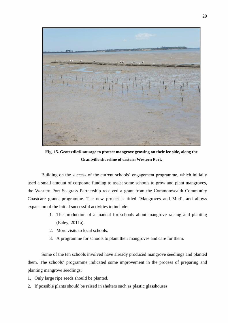
Project 2: Grantville coastline
The Coastcare Victoria Community Grants Programme funding was used to support the
second project, undertaken along the Grantville coast. In October 2009 a barrier of Geotextile®
bags was constructed to protect mangrove planting and prevent erosion (Fig. 15). In November
2009 mangrove seedlings were planted about 10 m along the lee side of the Geotextile® bags
and in a control area without protection. Very early the control plants were lost due to a strong
wash-out from a nearby creek but these were replaced. More mangroves survived in the
protected area than in the replanted control. However, other conditions may have affected the
result. Part of the kilometre of coastal planting specified in the project was completed by school
children and the remainder will be completed in 2012.
29
Fig. 15. Geotextile® sausage to protect mangrove growing on their lee side, along the
Grantville shoreline of eastern Western Port.
Building on the success of the current schools’ engagement programme, which initially
used a small amount of corporate funding to assist some schools to grow and plant mangroves,
the Western Port Seagrass Partnership received a grant from the Commonwealth Community
Coastcare grants programme. The new project is titled ‘Mangroves and Mud’, and allows
expansion of the initial successful activities to include:
1. The production of a manual for schools about mangrove raising and planting
(Ealey, 2011a).
2. More visits to local schools.
3. A programme for schools to plant their mangroves and care for them.
Some of the ten schools involved have already produced mangrove seedlings and planted
them. The schools’ programme indicated some improvement in the process of preparing and
planting mangrove seedlings:
1. Only large ripe seeds should be planted.
2. If possible plants should be raised in shelters such as plastic glasshouses.

30
3. Rich sandy soil or good quality potting mix should be used.
4. Seedlings should not be planted out until they have six leaves at which stage they are more
likely to survive infestations by barnacles or smothering by sea wrack. A strong root system
will have developed by this stage.
5. Tops of cartons should be stapled together before planting out to give plants further support.
Project 3: Melbourne Water Project
All planting undertaken by Melbourne Water (with Tom Hurst as the project manager)
has been along the eroding coastline north of the Lang Lang River. The main purpose of this
project is to attempt establishing mangroves for stabilisation of the eroding north-east coastline
as recommended by Wallbrink et al. (2003). It is predicted that this will reduce the amount of
sediments entering the bay and benefit the health of seagrass populations.
Melbourne Water planted about 13,000 seedlings over about 4 km of shoreline in
May/June 2011 and plan to put in another 10,000 starting in April 2012. No final survival count
has been made, but two preliminary counts indicate a 30% survival rate. The method used by
Ealey (2011b) in stapling the milk carton tops yielded a better survival rate (around 70–80%,
Hurst pers. comm.) than cartons without staples or seedlings planted without carton protection.
Melbourne Water will be using this technique for the coming plantings.
Over summer 2011/12, a direct seeding technique was trialled that worked very well in
some smaller trials. But there were problems with crabs eating the seeds at Lang Lang and
further work is continuing to overcome this source of seedling mortality. There are important
logistical advantages to direct seeding over planting established young seedlings, largely arising
from the smaller volumes that need to be transported to the field sites. Only propagules are
transported, and 60 of these fit into a tray (Fig. 11) compared with seedlings in milk cartons,
which weigh around 1 kg each.
More than 3000 seedlings were planted around Grantville and Corinella as part of the
Tom Hurst’s MSc project and separate to the Melbourne Water undertakings outlined above.
These plantings are testing the effects of different intertidal zones and proximities to existing
mangroves on their survival and growth. They have been planted in areas where mangroves once
flourished but were removed and have been gone for many years. Survival rates are below 30%,
but low survival rates are not uncommon in mangrove restoration projects—this is also the case
in many restoration projects in tropical areas, let alone at the southern limit of their distribution.
Direct planting of seeds with bird wire cages to prevent crabs eating the seeds has had some

31
success. We should point out that the survival rates obtained by Ealey (2011a) in areas not
previously supporting mangrove, are very impressive.
2.9 Success of plantings
Planting success may be defined in a number of ways. First, sometimes success is
claimed if seedlings grow sufficiently to produce their own seedlings and their canopy, covering
the area planted, is similar to a nearby unaffected mangrove forest. Second, criteria, preferably
measurable as quantitative values, could be established prior to the commencement of planting
activities. Success can then be defined as the successful integration of plant material
establishment with fishery and wildlife habitat establishment and water quality improvements
(Lewis, 1989). This habitat equivalence can be measured with quantitative measures such as
species presence in conjunction with plant cover. The habitat measurements are compared with a
proximate mangrove forest. A third approach might be to set a numerical target for survival over
a given period: e.g., 70+ % survival of planted seedlings after one year.
2.10 Causes of mortality
Mangrove seedlings in southern Victoria face one main obstacle that other mangroves
usually do not—cold. They are killed or considerably damaged by frost and growth rates may be
reduced by long spells of cold weather. The result is that growth rates are not as fast as in
tropical mangrove forests.
It is likely that a range of other environmental factors may also come into play as
mortality factors. First, the elevational band occupied by mangroves in Western Port is quite
narrow (Boon et al., 2010), and it is not clear from the planting so far carried out whether the
plants are being placed at the correct elevation with an appropriate tidal inundation. Moreover,
slightly raised areas may exist that allow mangroves to growth successfully in zones that would
otherwise be too deep for them: the role of such subtle microtopographic variations in the
success of wetland revegetation has recently been shown with the wetlands that fringe the
Gippsland Lakes (Raulings et al., 2010, 2011; Boon, 2011).
Second, waves and erosion (including backwash from cliffs) may remove plants.
Protection was given in some cases but stapled milk cartons and wood planks to protect
seedlings have not been entirely successful.
Third, physical damage is increased by fishing lines, debris and seagrass drift all
accumulate on seedlings. Their increased surface area then provides more resistance to waves

32
and increases the likelihood of the seedlings being washed out. If heavy enough, this debris
reduces photosynthesis.
Fourth, consumption by insects and smothering by barnacles growing on the leaves may
cause some problems. It is noteworthy that Hong (1996) and Satumanatpan and Keough (1999)
have marshaled empirical evidence to show that barnacles are not a significant cause of seedling
mortality., and this is in contrast to the observations of Ealey (2011b).
Clarke and Allaway (1993) commented that herbivory of post-dispersal mangrove
propagules by crabs was less important in temperate than tropical parts of Australia. Consistent
with this suggestion, individuals of the temperate Australian mangrove crab Helograpsus
haswellianus did not consume propagules of Avicennia marina when offered them in laboratory
experiments (Imgraben and Dittmann, 2008). In the research of Ealey (2011b) it was found that
some plants grown from seeds directly planted in the mud seemed to do well but often the seeds
were eaten by crabs.
Another source of irritation to the efforts of planting mangrove and mortality to seedlings
is direct human vandalism of planted mangrove seedlings. This is often attributed to people who
do not want mangrove stands in front of their properties or who consider that mangroves are a
haven for and attract mosquitoes.
2.11 Possible solutions to lowering mortality
Before solutions to improve survival can be devised, it is necessary to first determine the
cause(s) of mortality. In the absence of this information, we can only propose as possible
solutions the follow options.
A cost-effective method for attenuating wave energy to protect a coastal mangrove
plantation was developed by Halide et al. (2004) in Indonesia. The design used bamboo poles, a
strong, cheap, environmentally friendly and widely available material in tropical developing
countries. The bamboo poles were pushed into the sediment offshore from the coastal mangrove
plantation. A numerical model was used to determine performance in reducing incidental wave
energy. A field experiment on a mud bank suggested that the bamboo be pushed in no less than
600 mm to avoid scouring and dislodging with 1 m protruding above the bank surface. Although
bamboo is not as readily available in Victoria, some other natural product might be used, e.g., tea
tree (Melaleuca ericifolia) or wooden pickets. At the same time these are deployed, records of
cliff position should be taken as the barriers may also be protecting eroding cliffs.
The problems of drift detritus being caught in newly planted seedlings are partially
overcome when seedlings are only planted when they have six leaves (Ealey, 2011b). He

33
suggests that this robustness allows plants to withstand barnacle infestation and be strong enough
to hold seagrass wrack.
The stapled milk carton used by Dr Ealey’s team is a useful addition to making a hole
and placing the seedling in it. A specially designed tool, shaped as a milk carton base, is pushed
into the substrate and the milk carton containing a mangrove seedling is then placed in the
resultant hole. The carton has been stapled at its top to prevent the seedling washing out yet an
opening is left to allow leaves to receive sunlight.
Planting mangrove in clumps, rather than in rows a metre apart may be useful in their self
protection but experiments are needed to test this idea.
2.12 Strategy for future planting
More plantings are planned in 2012 with available seedlings and it is anticipated that all
will be done with stapled milk cartons. Much of the planting will be done by school children,
which has the benefit of raising the awareness of mangroves among the wider community,
showing the problems with working in estuarine environments, and illustrates the range of other
marine issues and value of team work for these children.
There is, however, no long-term strategy or plan for mangrove planting in Western Port.
Departments responsible have not developed a strategic plan for erosion control, reducing
sediment, mangrove revegetation or establishment in areas where mangroves seemingly did not
occur in the recent past, or rehabilitation in areas that they did. There are many reports
suggesting future plans and activities but, until now, no concerted effort has been made to reduce
sediments and sedimentation at the northern end of Western Port. A recent summary of current
knowledge and priorities for future research is useful in directing a strategic plan but it falls short
of actually providing a strategic plan (Melbourne Water, 2011). Until such a plan becomes
available, it is likely that mangrove revegetation will remain uncoordinated and sporadic.
3. Alternatives to mangrove planting
The clay banks along the eastern edge of Western Port are about 1–2 m high (Fig. 6). As
we have noted above, it is not clear whether the primary goal of the mangrove revegetation
activities is to prevent erosion of these clay banks or cliffs and other coastal erosion hotspots, or
whether it is to provide coastal habitat, or even to protect the seagrass beds that lie offshore.
Until the underlying reason for planting becomes clarified, it is difficult to suggest alternatives.
34
Notwithstanding this caveat, it may be appropriate to assume that the plantings are
designed to protect the hinterland. If so, one valid alternative is to design structures to protect
this land. Any structure should be constructed parallel to the shoreline, probably on the existing
erosion scarp. Areas below the cliffs clay mud and ooze may not be suitable for mangrove
establishment.
Structures such as revetments and seawalls are designed to halt further landward
progression of the shoreline by providing a hard shoreline for waves to break onto whilst also
retaining the soils behind the structure. They can also have a supplementary use in minimising
the inundation, through overtopping, of land areas by waves and storm surges, and thus protect
the land from erosion and from salinization. These structures range from vertical faced structures
such as massive concrete or masonry walls, e.g., the current wall along the Lang Lang foreshore,
sheet piled walls and gabions, to sloping structures made from Geotextile® bags, stone rubble,
concrete armour units or concrete panels. The large range of materials available for seawall
construction requires careful selection to suit the specific circumstances and site conditions.
Whilst structures such as these can be effective at preventing shoreline recession, they
also generally accelerate erosion of the seabed immediately in front of the structure due to
increased wave reflection directly caused by the structure. This results in increased depths that
allow larger waves to reach (and break on) the structure, and can discourage the natural
deposition of beach sediments. As a consequence, structures such as seawalls that are not well
founded may be at risk of instability caused by erosion of the seabed at the toe of the structure,
and by an increase in direct wave breaking, run-up, and overtopping. Because of their potential
vulnerability to toe scour, seawalls need to be founded below the predicted future erosion level,
or are sometimes used in conjunction with other erosion control techniques such as groynes and
beach nourishment. Seawalls also tend to create a stronger littoral current which may result in
localised scour at the down drift end of the structure, known as a ‘terminal scour’ zone.
Whilst the recycling of concrete for use in structures may be desirable, there can be
significant environmental and aesthetic impacts associated with its use. It has some of the ‘hard’
characteristics desirable for use in a seawall, its practical use is limited as most rubble is not
specifically designed for use in harsh marine environments and it will progressively deteriorate.
Evidence of this from the existing concrete rubble on the shoreline area is shown in Fig. 16.

35
Fig. 16. Concrete rubble used to prevent erosion along the Lang Lang clay cliffs
Within Western Port there are many examples of seawalls, including some that have
failed and some that have been successful in stopping the advancement of coastal erosion (Fig.
17). In the example shown in Fig. 17, a low wall has prevented erosion along a section of the
coast south of the ramp and the effects of erosion can be seen to the north where Melaleuca trees
have fallen down.

36
Fig. 17 Ramp at Malcolm Drive in Pioneer Bay. Note the vegetation and level of the beach on the RHS where a low cement wall was built compared with the LHS where trees are uprooted and the
erosion has receded further. This in not thought to be due to longshore drift.
A typical rubble mound seawall includes several layers of materials such as outer armour
(rocks or sandbags), and internal filter layers to allow the dissipation of groundwater without
allowing the retained soil to be extracted through the wall. Construction of seawalls will also
generally require the use of heavy earthmoving equipment and excavations to develop an
appropriate foundation. The other major disadvantage of these structures is the substantial cost of
materials and construction. In general, structures such as seawalls and revetments are considered
to be ‘the last line of defence’, and due to their considerable expense, tend to be mainly used for
public safety purposes or to protect important infrastructure that is not able to be relocated (taken
from GHD, 2010 report).
4. Discussion This review was commissioned by the Western Port Seagrass Partnership to determine
the usefulness of planting mangroves at the northern end of Western Port. By reducing water
column sediment load it is hoped that seagrass will return to this area. During March 2012, we
visited field sites of mangrove planting and saw eroded cliffs e.g., see Fig. 6. We had interviews

37
with people involved in actually planting mangroves and we examined the many reports that
have appeared on sedimentation, erosion, light reduction and mangrove planting.
Our conclusions are that, although mangrove restoration and creation may eventually
reduce erosion of the Lang Lang cliffs, stabilise some sediment moving around on unvegetated
mudflats and add to biodiversity and bird life, it will not, in the immediate future, save the
seagrass beds nor help increase light availability to the seagrasses. At the very first, what is
required is a thorough understanding and agreement on the scale of the problem(s), their
ecological, social and financial costs, and the range of actions that can be implemented to reduce
the problems and thus offset the associated costs. It can be argued that what is required is a large
financial investment in structures to reduce wave action onto the coast. These may be as simple
as Geotextile® sausages or low seawalls. The more costly structures are probably prohibitively
expensive.
It appeared to us that much encouragement was given to the enormous efforts of
dedicated people in growing mangroves and little in kind or funding assistance to actually solve
the problem of sedimentation and turbidity in Western Port. Government agencies seem to
sponsor and encourage many reports, seminars and meetings but fail to come to the real terms of
the problem and provide suitable funding to solve it.
Although a large financial investment is required to improve water quality, plant
mangrove, restore seagrass and make some engineering changes, funding from offsets that will
be required for the new port development at Hastings should be considered for this purpose.
As mentioned earlier some attempts to grow mangroves are in areas where mangrove has
not grown in the recent past (100–20years). Lewis (pers. comm.) recommends test plantings, and
planting along a topographic gradient to test survival. This suggestion is consistent with the
findings of recent research into the rehabilitation of coastal brackish-water in the Gippsland
region (Raulings et al., 2010, 2011; Boon, 2011). He also suggests choosing locations where
mangroves can self-seed and can thrive (given of course the issue of propagule limitation, a topic
of his 2005 paper (Lewis, 2005). That location, by necessity, has not been identified for this area.
Lewis (pers. comm.) also suggests zonal test plantings over a range of topographic elevations
from what appears to be ‘too high’ to ‘too low’ and following them quantitatively over time.
This would help solve the issue of topographical gradient. It does not appear that this ‘zone of
likely success’ approach has been implemented in the current trials..
Based on figures from real estate sales advertisements in the Lang Lang area we
estimated that the current value of grazing ground near the Lang Lang cliffs is about $13,000 per
hectare. If, as Anon (2012) estimates, there are 10 m of coast being eroded in three years and the

38
eroded coast is 11 km long the value of land lost per year, assuming three metres are lost, is
$429,000. Management agencies and farmers should keep this in mind when they are
considering investment decisions and on-ground actions.
5. Recommendations
1. Despite the recent comprehensive reviews of Western Port and its mangroves (Boon et
al., 2011; Melbourne Water, 2011), there is still no strategic plan for this coastline and
this remains a priority.
2. Management arrangements for coastal wetlands in Victoria are complex and mostly
insufficient to the task (Boon et al., 2011) and need to be considered when devising
revegetation activities and associated attempts at shoreline protection.
3. A recent media release and seminars hosted by Melbourne Water are the first efforts to
get better attention to the issues of seagrass decline, mangrove planting and coastal
erosion, but media coverage must be increased, targeted and improved. This coverage
should take into account the social marketing research undertaken by Boon et al. (2011)
and adopt a ‘stages of behavioural change’ model. The current level of understanding of
coastal wetlands is rudimentary and at a base ‘pre-contemplation’ stage (Fig. 17).
Pre-Contemplation
People do not know about coastal saltmarsh communities, let alone the issues.
Action: raise awareness
Contemplation
People know about the issues and are thinking about the benefits to action, but are not yet convinced.
Action: demonstrate benefits, cost savings
Action
People are starting to take action to protect coastal saltmarshes & mangroves and know the consequences of their actions.
Action: advocate, improve ability to act
Maintenance
People are committed but need feedback & reminders of the benefits / impacts of their actions from time to time.
Action: reward/remind
Fig 17: Four stages in the ‘stage of behavioural change’ model used to interpret community perceptions of coastal wetlands in Victoria. Outcomes of the focus-group workshops indicate that the general community is in the ‘pre-contemplation’ stage, indicated in red in the above
schematic. Source: Figure 3.2 of Boon et al. (2011).
4. A crucial first step is that the rationale for mangrove planting be made explicit; e.g., is it
for shoreline protection, creation of coastal habitat, or to facilitate seagrass re-
establishment?

39
5. Planting activities should be planned within an explicit framework that sets out testable
hypotheses as to the effects of plant age, planting method, and position in the landscape,
e.g., elevation and tidal inundation.
6. Explicit measures of revegetation success need to be established, using criteria that are
measurable, realistic and amenable to rigorous statistical analysis.
7. All reporting on the success of mangrove plantings should be quantitative and quantify
the same suite of variables, so that a comparison can be made across different areas,
times and methods. A database should be established where all operations of all
organizations are mandated to be entered, including their planting data, dates,
survivorship, planting methods, position, reason for planting.
8. Specific experiments should be undertaken to determine the best elevation and/or tidal
regime to plant and the best position along the eroded Lang Lang cliffs to have successful
survival of seedlings and subsequent growth of adults. We have seen very little research
on planting density and it may be useful to test densities and clump sizes for best
survival.
9. More rigorous experimental procedures should be used. A distinction between growing
mangrove along the coast to potentially prevent erosion of the cliffs and research to
decide on density and position of seedling planting and most efficient methods should be
made.
10. Careful biannual measurement of erosion from the cliffs is required. This should
distinguish between erosion by freshwater from runoff down cliff faces and erosion by
wave action from the sea.
Acknowledgments
Sincere thanks are given by the authors to Dr Tim Ealey who advised on his planting
techniques and took us out to see the mangrove plantings at the northern end of Western Port.
His enthusiasm for the wider mangrove revegetation project is to be commended and built upon.
Tom Hurst also took us to the Lang Lang cliffs and showed us the saltmarsh and mangrove
plantings. His skill and rigour are also to be commended; we are also indebted to him for
allowing us to put a draft copy of his mangrove review as an appendix to this report. This is a
draft literature review undertaken as part of an MSc at Deakin University and can only be cited
after gaining his permission.

40
References Anon. 2012. Lang Lang Foreshore Reserve Coastal Management Plan. Department of
Sustainability and Environment. 60 pp.
Aronson, J., Milton, S.J. and Blignaut, J.N. 2007. Restoring natural capital: definition and
rationale. In: Restoring Natural Capital: Science, Business and Practice. Eds: Aronson, J.,
Milton, S.J. and Blignaut, J.N. Society for Ecological Restoration International, Island Press,
Washington, DC. Pages 3–8.
Badola, R. and Hussain, S.A. 2005. Valuing ecosystem functions: an empirical study on
the storm protection function of Bhitarkanika mangrove ecosystem, India. Environmental
Conservation 32: 1–8.
Bird, E.C.F. 1986. Mangroves and intertidal morphology in Westernport Bay, Victoria,
Australia. Marine Geology 69: 251–271.
Bird, E.C.F. and Barson, M.M. 1975. Shoreline changes in Westernport Bay. Proc. Roy.
Soc. Victoria 87: 15–28.
BOM. 2010. Climate Data Online, Commonwealth of Australia, retrieved Jan 2012,
<http://www.bom.gov.au/climate/data/>.
Boon, P.I., White, M. and Sinclair, S. 2010. Climate change impacts on Victoria's
Coastal Vegetation (Mangroves and Saltmarsh): Western Port Case Study. Paper presented to
Practical Responses to Climate Change National Conference 2010, Melbourne.
Boon, P.I. 2011. The rehabilitation of coastal wetlands: why small-scale variations in
topography are critical to success. Australasian Plant Conservation 20: 9–10.
Boon, P.I., Allen, T., Brook, J., Carr, G., Frood, D., Hoye, J., Harty, C., McMahon, A.,
Mathews, S., Rosengren, N., Sinclair, S., White, M. and Yugovic, J. 2011. Mangroves and
coastal saltmarsh of Victoria: distribution, condition, threats and management. Report to DSE
(Bendigo) by Institute for Sustainability and Innovation, Victoria University, Melbourne. 513 pp.
Bradshaw, A.D. 1997. What do we mean by restoration? In: Restoration ecology and
sustainable development. Ed: Urbanska, K.M. et al. Cambridge University Press, Cambridge.
Pages 8–14.
Bulthius, D., Brand, G.W. and Mobley, M.C. 1984. Suspended sediments and nutrients in
water ebbing from seagrass-covered and denuded tidal mudflats in a southern Australian
embayment. Aquatic Botany 20: 257–266
Church, J.A., White, N.J., Hunter, J.R. and Lambeck, K. 2008. Briefing: a post-IPCC
AR4 update on sea-level rise. The Antarctic Climate and Ecosystems Cooperative Research
Centre, Hobart.

41
Clarke, P.J. 1993. Dispersal of grey mangrove (Avicennia marina) propagules in
southeastern Australia. Aquatic Botany 45: 195–204.
Clough, B.F. and Attiwill, P.M. 1975. Nutrient cycling in a community of Avicennia
marina in a temperate region of Australia. In: International Symposium on Biology and
Management of Mangroves. Eds: Walsh, G.E., Snedaker S.E. and Teas, H.J. University of
Florida, pages 137–146.
DSE. 2008. Climate Change in Port Phillip and Westernport. Department of
Sustainability and Environment., Victorian Government.
DSE. 2011. The Lang Lang Foreshore Reserve Coastal Management Plan. Department
of Sustainability and Environment., Victorian Government. pp. 62.
Dittmann, S. 2011. Mangroves. In: Understanding the Western Port Environment. A
Summay of Current Knowledge and Priorities for Future Research. Melbourne Water
Corporation. Pages 106–115.
Clarke, P.J. and Allaway, W.G. 1993. The regeneration niche of the grey mangrove
(Avicennia marina): effects of salinity, light and sediment factors on establishment, growth and
survival in the field. Oecologia 93: 548–556.
Ealey, T. 2011a. Mangrove Planting Manual. Western Port Seagrass Partnership. pp. 16
Ealey, T. 2011b. Brief History of the Lang Lang Mangrove Project (Revised). A report to
Western Port Seagrass Partnership. pp. 5.
Field, C. 1998. Rehabilitation of mangrove ecosystems: an overview. Marine Pollution
Bulletin 37: 383–392.
Field, C. 1999. Mangrove rehabilitation: choice and necessity. Hydrobiologia 413: 47–
52.
Gedan, K.B., Kirwan, M.L., Wolanski, E., Barbier, E. B and Silliman, B.R. 2011. The
present and future role of coastal wetland vegetation in protecting shorelines: answering recent
challenges to the paradigm. Climatic Change 106: 7–29.
GHD. 2002. Western Port Erosion Project. Report prepared for the Department of
Natural Resources and Environment, Victorian Government.
GHD. 2010. Cardinia Shire Council Management Plan for Lang Lang Clay Banks
Stabilisation. December 2010. pp 72.
Halide, H., Brinkman, R. and Ridd, P. 2004. Designing mangrove wave attenuators for
mangrove plantations. Indian Journal of Marine Sciences 33: 220–225.
Harty, C. 2010. Mangroves in Western Port Discussion Paper. Department of
Sustainability and Environment, Victorian Government.

42
Harty, C. 2011. Mangroves of Victoria Information Kit. Parks Victoria. 22 pp.
Hobbs, R.J. 2005. Restoration ecology and landscape ecology. In: Issues and
Perspectives in Landscape Ecology. Eds: Weins, J.A. and Moss, M.R. Cambridge University
Press, Cambridge.
Hurst, T. 2011. Mangrove Restoration in Western Port Literature Review. See Appendix
1.
Imgraben, S. and Dittmann, S. 2008. Leaf litter dynamics and litter consumption in two
temperate South Australian mangrove forests. Journal of Sea Research 59: 83–93.
Lake, P.S. 2001. On the maturing of restoration: linking ecological research and
restoration. Ecological Management and Restoration 2: 110–115.
Lewis, R.R. III. 1989. Wetland restoration/creation/enhancement terminology:
suggestions for standardization. In: Wetland Creation and Restoration: The Status of the Science.
Eds Kusler, J.A. and Kentula, M.E. Island Press, Washington DC. Pages 417–422.
Lewis, R.R.III. 2005. Ecological engineering for successful management and restoration
of mangrove forests. Ecological Engineering 24: 403–418.
Lewis, R.R.III. 2009. Knowledge overload, wisdom underload. Ecological Engineering
35: 341–342.
Lewis, R.R.III. 2011. How successful mangrove forest restoration informs the process of
successful general wetland restoration. National Wetlands Newsletter 33:23–25.
McManus, P. (2006). Mangrove battlelines: culture/nature and ecological restoration.
Australian Geographer 37: 57–71.
Melbourne Water. 2011. Understanding the Western Port Environment. A Summary of
Current Knowledge and Priorities for Future Research. Melbourne Water Corporation, Victoria.
pp. 224.
Morrisey, D.J., Swales, A., Dittmann, S., Morrison, M.A., Lovelock, C.E. and Beard,
C.M. 2010. The ecology and management of temperate mangroves. Oceanography and Marine
Biology: An Annual Review 48: 43–160.
Parsons Brinkerhoff. 2009. Geotechnical Risk Assessment – Coastal Crown Land in West
and South Gippsland.
Raulings, E., Morris, K, Roache, M. and Boon, P.I. 2011. Is hydrological manipulation an
effective management tool for rehabilitating chronically flooded, brackish-water wetlands?
Freshwater Biology 56: 2347–2369.

43
Raulings, E., Morris, K, Roache, M. and Boon, P.I. 2010. The importance of water
regimes operating at small spatial scales for the diversity and structure of wetland vegetation.
Freshwater Biology 55: 701–715.
Rogers, K, Wilton, KM and Saintilan, N. 2006. Vegetation change and surface elevation
dynamics in estuarine wetlands of southeast Australia. Estuarine, Coastal and Shelf Science 66:
559–569.
Ryder, D., Brierley, G.J., Hobbs, R., Kyle, G. and Leishman, M. 2008. Vision generation:
what do we seek to achieve in river rehabilitation? In: River Futures. An Integrative Scientific
Approach to River Repair. Eds: G.J. Brierley and K.A. Fryiers. Island Press, Washington. Pages
16–27.
Samson, M.S. and Rollon, R.N. 2008. Growth performance of planted mangroves in the
Philippines: revisiting forest management strategies. Ambio 37: 234–240.
Satumanatpan, S. and Keough, M. 1999. Effect of barnacles on the survival and growth
of temperate mangrove seedlings. Marine Ecology Progress Series 181: 189–199.
SER (Society for Ecological Restoration International). 2002. Society for Ecological
Restoration International’s Primer of Ecological Restoration. http://www.ser.org/Primer
Shepard, C.C., Crain, C.M. and Beck, M.W. 2011. The protective role of coastal marshes:
a systematic review and meta-analysis. PlosOne 6: e27374.
Wallbrink, P.J., Hancock, G.J., Olley, J.M., Hughes, A., Prosser I. P, Hunt, D., Rooney,
G., Coleman, R. Stevenson, J. 2003. The Western Port Sediment Study. CSIRO Consultancy
report, 2003.
Wallbrink P.J. and Hancock G. 2003. Western Port Sediment Study: Background and
Literature Review. Technical Report 12/03, CSIRO.
Zedler, J.B. 2006. Wetland restoration. In: Wetlands. Eds: Mitsch, W.J. and Gosselink,
J.G. 2nd edition. Van Nostrand Reinhold, New York. Pages 348–406.

44
Appendix 1.
Mangrove Restoration in Western Port Bay Literature Review Tom Hurst. July 2011