resolution no. 2003-229 grove … approving a tentative subdivision map and design review ......
TRANSCRIPT

RESOLUTION NO. 2003-229
A RESOLUTION OF THE CITY COUNCIL OF THE CITY OF ELKGROVE APPROVING A TENTATIVE SUBDIVISION MAP AND DESIGN REVIEWFOR THE SHIRES PROJECT NO. EG-03-418, SUB..IECT TO THE FINDINGS AND
MMRP/CONDITIONS OF APPROVAL
WHEREAS, The Shires, represented by Paul and Machelle Emmerich(hereinafter referred to as Applicants) filed an application with the City of Elk Grove(hereinafter referred to as City) for a Rezone, Tentative Subdivision Map and DesignReview. (Assessor's Parcel Number 127-0070-008); and
WHEREAS, the City Council is the appropriate authority to hear and take actionon this project after a recommendation by the Planning Commission; and
WHEREAS, an Initial Study was prepared for this project and a Notice of Intentto Adopt a Mitigated Negative Declaration was prepared and circulated according to therequirements of the California Environmental Quality Act (CEQA); and
WHEREAS, the Planning Commission considered the Applicant's request at apublic hearing on August 14, 2003 and recommended City Council approval of theproject.
NOW, THEREFORE, THE CITY COUNCIL OF THE CITY OF ELK GROVEHEREBY RESOLVES AS FOLLOWS:
1. Approve the Shires Tentative Subdivision Map and Design Review based on thefollowing findings and the attached subdivision map and conditions of approvalincluded as Exhibit A and B.
Findings
CEQA
Finding: The proposal will not have a significant adverse impact on the environmentand a Mitigated Negative Declaration has been prepared and completed in accordancewith the California Environmental Quality Act (CEQA).
Evidence: An Initial Environmental Study was prepared for the proposed project andmitigation measures have been developed that will reduce potential environmentalimpacts to less than significant levels. On the basis of the Mitigated NegativeDeclaration, comments received, and the whole record, there is no substantial evidencethat the project will have a significant adverse impact on the environment.

General Plan
Finding: The City shall not approve any proposed development project unless thefollowing findings are made, based on substantial evidence in the record:
(a) There is a reasonable probability that the land use or action proposed will beconsistent with the general plan proposal being considered or studied or which willbe studied within a reasonable time.
(b) The project is consistent with the latest version of the Draft Land Use Policy Mapand any draft General Plan Elements which have been reviewed by the GeneralPlan Advisory Committee as of the date on which the project is approved.
(c) There is little or no probability of substantial detriment to or interference with thefuture adopted general plan if the proposed use or action is ultimately inconsistentwith the plan.
(d) The proposed use or action complies with all other applicable requirements of statelaw and local ordinances.
Evidence:
(a,b) The proposed Draft General Plan Land Use Map identifies the property as RuralResidential with a 2 acre minimum. The project as proposed is consistent with theland use densities, draft policies and design within the Elk Grove General Plan.
(c) The project is consistent with existing land use entitlements required for this propertyby the Elk Grove General Plan. The General Plan has identified the areas east ofBradshaw Road and north of Bond Road for Rural Residential development with a 2acre minimum lot size. The project is consistent with the General Plan and has beenconditioned appropriately.
(d) The requested Rezone and Tentative Subdivision Map are consistent with state lawand local ordinances as discussed by the following findings and evidence.
Tentative Subdivision Map
Finding: Section 66474 of the California Subdivision Map Act requires a City to denyapproval of a tentative map if it makes any of the following findings:a. That the proposed map is not consistent with applicable general and specific plans
as specified in Section 65451.b. That the design or improvement of the proposed subdivision is not consistent with
applicable general and specific plans.c. That the site is not physically suitable for the type of development.d. That the site is not physically suitable for the proposed density of development.
2

e. That the design of the subdivision or the proposed improvements are likely to causesubstantial environmental damage or substantially and avoidably injure fish orwildlife or their habitat.
f. That the design of the subdivision or type of improvements is likely to cause seriouspublic health problems.
g. That the design of the subdivision or type of improvements will conflict witheasements acquired by the public at large, for access through or use of, propertywithin the proposed subdivision.
Evidence: The above Findings #a. through #g. do not apply to the proposed TentativeSubdivision Map.a. The proposed map is consistent with the Elk Grove General Plan and rezone.b. The design of the improvements of the proposed subdivision is consistent with the
General Plan and design standards of the municipal code.c. The site is physically suitable for extension of residential development and is
consistent with the specific plan.d. The site is appropriate for the specified density of development and the applicant's
proposed amendments to commercial densities as presented in the staft report.e. The Mitigated Negative Declaration prepared for the Shires project determined that
potential environmental impacts from the desiqn of the subdivision or the proposedimprovements will be mitigated to less than significant levels with implementation ofthe proposed Mitigation Measures and Conditions of Approval.
f. The Mitigated Negative Declaration prepared for the Shires project determined thatno potential serious health problems were identified from the project.
g. No conflict with easements acquired by the public at large, for access through or useof, property within the proposed subdivision, have been identified.
Design Review
Finding: The proposed project is consistent with the objectives of the General Plan,complies with applicable zoning regulations, Specific Plan provisions, Special PlanningArea provisions, and Citywide Design Guidelines adopted by the City.
Evidence: The proposed Draft General Plan Land Use Map identifies the property asRural Residential with a 2 acre minimum. The project as proposed is consistent withthe land use densities, draft policies and design within the Elk Grove General Plan. TheGeneral Plan has identified the areas east of Bradshaw Road and north of Bond Roadfor Rural Residential development with a 2 acre minimum lot size. The project isconsistent with the General Plan and has been conditioned appropriately.
Finding: The proposed project will not create conflicts with vehicular, bicycle, orpedestrian modes of transportation.
Evidence: The project has been conditioned to provide right-of-ways for a circulationpattern consistent with the requirements of the General Plan. Roadways have bicyclelanes where necessary and a trail system/landscape corridor has been provided along
3
Bond Road. The project has been designed to preserve the natural features of theproperty.
Finding: The residential subdivision is well integrated with the City's street network,creates unique neighborhood environments and establishes a pedestrian friendlyenvironment.
Evidence: The City's Design Guidelines has identified that projects should be designedto preserve the unique features of various properties. The Shires property containsnumerous large oak trees and the subdivision has been designed to preserve the treeson-site. The project proposal includes a landscape corridor and trail system along BondRoad that would allow for increased pedestrian circulation opportunities along BondRoad.
Exception
Finding: The granting of the exception will not be detrimental to the health, safety,comfort or general welfare of persons residing or working in the subdivision and that therequirements to provide domestic water supply would create a financial burden.
Evidence: Staff from County Sanitation District 1, Sacramento County Zone 40 Waterand Sacramento County Environmental Health Department have been contacted inregard to the ability of two-acre parcels to provide adequate spacing for septic tanksand domestic water wells and the long-term effect on the aquifer within the Sheldonarea. The is no evidence in the record or evidence provided to indicate that the healthof surrounding neighbors will be compromised. The applicant has also providedevidence that the cost of domestic water service is prohibitive.
PASSED AND ADOPTED by the City Council of the City of Elk Grove on the 19th
day of November 2003.
~~~...sl-ii SCHERriA:MAYOROftheCITY OF ELK GROVE
ANTHONY B. MANZANETTI,CITY ATTORNEY
ArrEST:
PEGGY E. JACK ON, CITY CLERK
4

CERTIFICATIONELK GROVE CITY COUNCIL RESOLUTION NO. 2003-229
STATE OF CALIFORNIA )COUNTYOFSACRAMENTO) ssCITY OF ELK GROVE )
I, Peggy E. Jackson, City Clerk of the City of Elk Grove, California, do herebycertify that the foregoing resolution was duly introduced, approved, and adoptedby the City Council of the City of Elk Grove at a regular meeting of said Councilheld on the 19th day of November 2003 by the following vote:
ABSTAIN 0: COUNCILMEMBERS:
ABSENT 0: COUNCILMEMBERS:
AYES 5:
NOES 0:
COUNCILMEMBERS:
COUNCILMEMBERS:
Scherman, Soares, Briggs, Cooper, Leary\\\\111111"
",,:\'\ Of £L~ (J////....' ~\ ••.•....... ,po ........
..... . . p"...... '··cQRPO,q..., -. ('f' ....
::: ....'~ ~'"-:,,=.. ; 0\ =- :. JUly" 2000 .: * ::-:;. ····.~,.A ~./ ~~ C' ..... rE O~.•, -:.... "'1 ...... ,
..../,,/ l/~ORN\p.. ""
~~Pefl9Y.li8Ckson, City ClerkCity of Elk Grove, California
P:\CITY COUNCIL\RESOLUTIONS\Certiflcation to Resolutions doc

Exhibit A
TENTATIVE MAPFOR
THE SHIRESA.P.N. 127-0070-008
CITY OF ELI( GROVESACRAMENTO COUNTY CALIFORNIA
-1-
f1.t\fifilli~Sil.I..lMl,'-" .... r .......rr ...~"". I," CIla~I_ '.".... '0."U< rOQV! Co ,'u.h "I '!O',''''''c' OI I ..... ,IUlf "'
GRAPHIC SC,.\LE
m!N[Ripty£LQII[R
[""STjNe ZONIN::;
., .. o"'u. {.~I.h·
~~ : ~~~(~~~.~'::;::;",t. ( • l"'.~t..(, at'{,] r.<[ .. r.r." ~ • ""t"~ .....r OU['~' "rO'('"'O"
;~ L : ;;;~'~::~t'~~~;~;.,", ••tOolI1 ('n ..,a'.,.,.·.....<t.lI ·,f·t.,\..\·01
PROpERTY INfOR.. A7\QN
PROJECT INFORMATION
, .. vo.~,
Ile_"'".",...'" ••'\'1.1("(....... ,((,,, O' 1,_ ~.O"'f.·.'.-.;l.O...."
P"Ql[,cr SLJ~MAi!)
"·1 ,~" - ! ('It
::~ ~\~:. ~:I~:';;:";::;I&~:'I~'{~' I,·;t .-;._, .-.
eLl &. fllb !tb~PLS
~......11'"11'\ "1 ..." .'01 to""''''1
~O""U'r'~t"==..·'·.. ·,"n' ..<l.. ~-<l~
U~ll.~,~,I .....<\.. "H,M."",
.. . ....~
4
2
2.'1 "'C:t(CROSS)2 00 AC"(NET)_ '
2.,1, ",C:t.(GROSS)204 AC:t.(NET)
5
2.16 AC:t-(CROSS)
213 AC"(NE'l
2 Q7 "'''(GIl0SS)2 02 AC.t.(NET)
6
..a14 "'''(GllOSS)~ 02 A.C:t(NET)
... ec ~[\ ",-
. ,
sec
2 93 AC:t(GROSS)267 "'Ci:{NE.T)
10
9
Or -i •
2 ... 'C"(C/OOSS)2 55 ",Cz(NET}
• f"
BOND' ROAD""
:.(~
8
7
i ~ ~C~(GROSS)24. AC"("ET)
\
:_-'O_O{L( a a,(.,.
2 '" AC"(CROSS) .216 AC.:t(N£TL
. '- "
~.
nilS n;",..1lVt W/I1' w,u 'Wo\IID rr 1ftc.llfICIQIlrf ~c:TlOIitl
I "e!J••
TYPICAL 50' STREET SECTION
r .;,""'.'.>T,-j_-,-~--,,--.--'LillJ~f""L~L-_---!~~~
'I$L'<"'II~ II. r "'Ir_ ,l11 'U'OI',I"
-------.Z.~.O-~h:~="f===?-""""-~~~r;.~»;--
TYPICAL 32' STREET SECTION
1/ '~C'1' 1_1( .. ,.' • "JI
'"'''<;:~,=+~~(,;.~''O<"'''
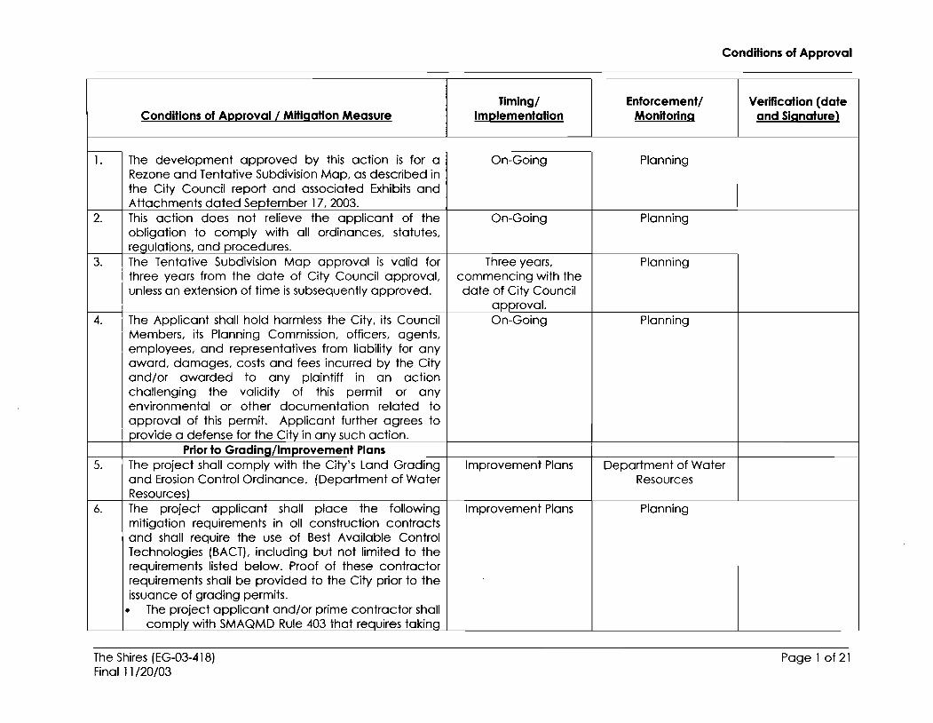
Conditions of Approval
Tlmlng/ Enforcement! Verification (dateConditions of Approval/Mitigation Measure Implementation Monitoring and Signature)
1. The development approved by this action is for a On-Going PlanningRezone and Tentative Subdivision Map, as described inthe City Council report and associated Exhibits andAttachments dated September 17, 2003.
2. This action does not relieve the applicant of the On-Going Planningobligation to comply with all ordinances, statutes,requlotions. and procedures.
3. The Tentative Subdivision Map approval is valid for Three years, Planningthree years from the date of City Council approval, commencing with theunless an extension of time issubsequently approved. date of City Council
approval.4. The Applicant shall hold harmless the City, its Council On-Going Planning
Members, its Planning Commission, officers, agents,employees, and representatives from liability for anyaward, damages, costs and fees incurred by the Cityand/or awarded to any plaintiff in an actionchallenging the validity of this permit or anyenvironmental or other documentation related toapproval of this permit. Applicant further agrees toprovide a defense for the City in any such action.
Prior to Grading/Improvement Plans5. The project shall comply with the City's Land Grading Improvement Plans Department of Water
and Erosion Control Ordinance. (Department of Water ResourcesResources)
6. The project applicant shall place the following Improvement Plans Planningmitigation requirements in all construction contractsand shall require the use of Best Available ControlTechnologies (BACT), including but not limited to therequirements listed below. Proof of these contractorrequirements shall be provided to the City prior to theissuance of grading permits.
• The project applicant and/or prime contractor shallcomply with SMAQMD Rule 403 that requires taking
The Shires (EG-03-418)Final 11/20/03
Page 1 of 21

7.
Conditions of Approval I Mitigation Measure
reasonable precautions to prevent the emissions offugitive dust, such as "using water or chemicals forcontrol of dust in the demolition of existing buildingsor structures, construction operations, theconstruction of roadways, or the clearing of land"where possible and applying "asphalt, oil, water, orsuitable chemicals on dirt roads, materials,stockpiles, and other surfaces which can give rise toairborne dust."
• Clean earth-moving construction equipment withwater once per day.
• Reduce traffic speeds on all unpaved surfaces to15 miles per hour or less.
• Use low-emission on-site stationary equipmentwhenever possible.
• Encourage construction employees to carpool tothe work site.
• Minimize idling time to 10 minutes.• Maintain construction equipment through regular
and proper maintenance.• All material transported offsite shall be either
sufficiently watered or securely covered to preventpublic nuisance.
• During initial grading. earthmoving, or sitepreparation a 100-foot paved (or palliativetreated) apron shall be constructed, extendingonto the construction site from the adjacent pavedroad{s) where vehicles and equipment egress.
• For projects within a one- mile radius of an activenest site, the project proponent should preserve0]5 acre of similar habitat for each acre lost. Thisland should be protected through a fee title orconservation easement acceptable to theCalifornia Department of Fish and Game /CDFG);
Timing/Implementation
Prior to Grading orother site
Improvements
Enforcement!Monitoring
Planning
Conditions of Approval
Verification (dateand Signature)
The Shires (EG-03-418)Final 11/20/03
Page 2 of 21

8.
9.
Conditions of Approval/Mitigation Measure
OR• Prepare and implement a Swainson' s hawk
mitigation plan to the satisfaction of the CaliforniaDepartment of Fish and Game that includes thepreservation of Swainson's hawk foraging habitat;OR
• Submit payment of a Swainson's hawk impactmitigation fee per acre impacted to theDepartment of Planning and CommunityDevelopment in the amount as set forth in Chapter16.130 of the Elk Grove Code as such may beamended from time to time and to the extent thatsaid Chapter remains in effect; OR
• Should the City of Elk Grove adopt a Swainson'shawk mitigation policy or program (which mayinclude a mitigation fee payable prior to theissuance of building permits) prior toimplementation of one of the measures above, theproject proponent may be subject to that programinstead.
Consult with the California Department of Fish andGame (CDFG) prior to approval of Improvement Plansor Building Permits, whichever occurs first, to ensurethat no individual take of Swainson' s hawk occurs. TheCDFG may require pre-development surveys todetermine the presence or absence of the hawk. Ifsuch surveys detect the hawk, the CDFG may imposerestrictions on proximate development during thenestinq season to ensure that take does not occur.
• If construction activities are expected to occurduring the nesting season (February-August), a preconstruction raptor survey shall be conductedwithin 30-days of the onset of construction todetermine the activity status of any nests found on
TIming/Implementation
Prior to Grading orother site
Improvements
Prior to Grading orother site
Improvements
Enforcement/Monitoring
Planning
Planning
Conditions of Approval
Verification (dateand Signature)
The Shires (EG-03-418)Final 11/20/03
Page 3 of 21

Conditions of Approval/Mitigation Measure
the project site. In the event that nesting raptors arefound, a 250' no-construction zone shall beestablished around the nest until the young havefledged.
• If construction activities commence during the nonbreeding season (September-January), a survey isnot required and no further studies are necessary.
• Prior to demolition of structures or thecommencement of construction activities ordisturbance of blackberry thickets, a survey shall beconducted by a qualified biologist to determinewhether or not raptors or tricolored blackbirds areutilizing the site. If present, abide by the biologist'srecommended measures to reduce or negateadverse impacts to these species.
• Applicant shall preserve on-site nesting and uplandforaging habitat where feasible, or purchasenesting and upland foraging habitat at off-sitepreserve sites.
• Prior to the approval of any grading and/orbuilding permits for the development of the site,applicant or project owner shall submit to the City acopy of any/all required DFG or USFWS permits andverification of any required consultation.
10. I The project proponent shall ensure that the project willresult in no net loss of any wetland habitat found onthe site. No net loss shall be achieved by the followingmethods:
a. Preserve and protect the existing on-site wetlands.
OR, if any wetlands are to be disturbed:
The Shires (EG-03-418)Final 11/20/03
TIming/Implementation
Prior to Grading orother site
Improvements
Enforcemenl/Monitoring
Planning
Conditions of Approval
Verification (dateand Signature)
Page 4 of 21

11.
Conditions of Approval/Mitigation Measure
b. Prior to any disturbance of on-site wetlands, submita Wetland Habitat Mitigation Plan to the City of ElkGrove for review and approval. The WetlandHabitat Mitigation Plan shall provide a detaileddescription of the size, location and design ofproposed wetland creation sites, and a detaileddescription of how the created wetlands will bemonitored and managed to ensure the success ofthe mitigation effort. OR
c. Prior to any disturbance of on-site wetlands,purchase credits at an approved wetlandmitigation bank. Documentation of such purchaseshall be submitted to City of Elk GroveDevelopment Services - Planning for review andapproval.
All trees on the project site that have been selectedfor preservation. all portions of adjacent off-site oaktrees which have driplines that extend onto the projectsite. and all off-site oak trees which may be impactedby improvements associated with this project, shall beprotected as follows:
1) A circle with a radius measurement from the trunkof the tree to the tip of its longest limb shallconstitute the dripline protection area of each tree.Limbs must not be cut back in order to change thedripline. The area beneath the dripline is a criticalportion of the root zone and defines the minimumprotected area of each tree. Removing limbs thatmake up the dripline does not change theprotected area.
2) Preliminary and Final Grodinq Plans, Improvement
TIming/Implementation
Condition shall beplaced on any/all
Preliminary and FinalGrading Plans,
Improvement Plansand
Building/DevelopmentPlans
Prior to Grading orother site
Improvements
Enforcement/Monitoring
Planning
Conditions of Approval
Verification (dateand Signature)
The Shires (EG-03-418)Final 11/20/03
Page 5 of 21
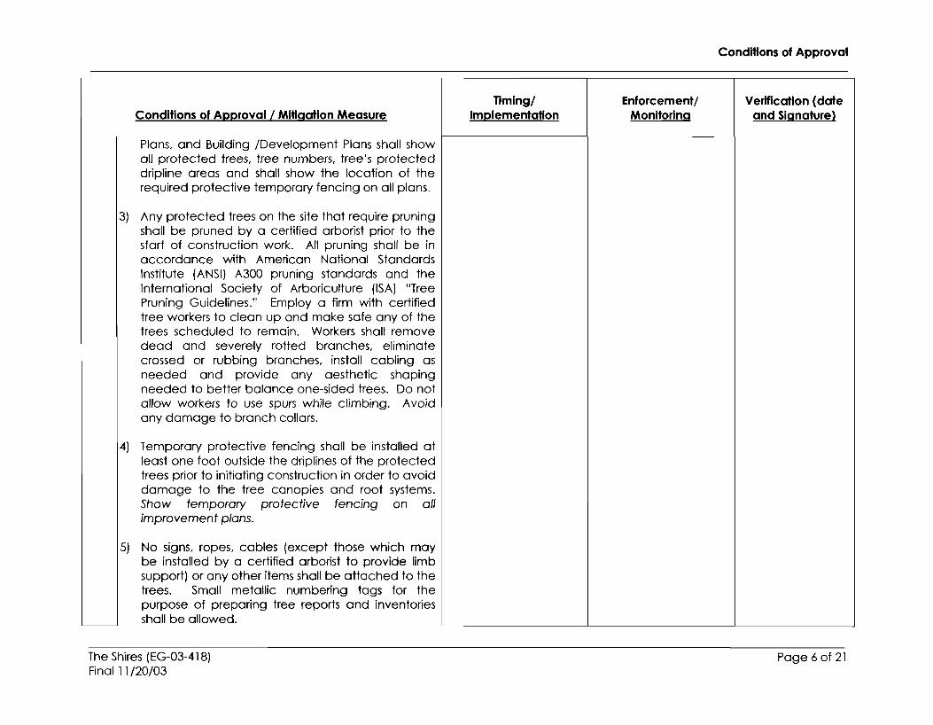
Conditions of Approval I Mitigation Measure
Plans, and Building /Development Plans shall showall protected trees, tree numbers, tree's protecteddripline areas and shall show the location of therequired protective temporary fencing on all plans.
3) Any protected trees on the site that require pruningshall be pruned by a certified arborist prior to thestart of construction work. All pruning shall be inaccordance with American National StandardsInstitute (ANSI) A300 pruning standards and theInternational Society of Arboriculture (ISA) "TreePruning Guidelines." Employ a firm with certifiedtree workers to clean up and make safe any of thetrees scheduled to remain. Workers shall removedead and severely rotted branches, eliminatecrossed or rubbing branches, install cabling asneeded and provide any aesthetic shapingneeded to better balance one-sided trees. Do notallow workers to use spurs while climbing. Avoidany damage to branch collars.
4) Temporary protective fencing shall be installed atleast one foot outside the driplines of the protectedtrees prior to initiating construction in order to avoiddamage to the tree canopies and root systems.Show temporary protective fencing on allimprovement plans.
5) No signs, ropes, cables (except those which maybe installed by a certified arborist to provide limbsupport) or any other items shall be attached to thetrees. Small metallic numbering tags for thepurpose of preparing tree reports and inventoriesshall be allowed.
The Shires (EG-03-418)Final 11/20/03
TIming/Implementation
Enforcement/Monitoring
Conditions of Approval
Verification (dateand Signature)
Page 6 of 21

Conditions of Approval/Mitigation Measure
6) No vehicles, construction equipment, mobilehome/office, supplies, materials or facilities shall bedriven, parked, stockpiled or located within thedriplines of protected trees.
7) No grading (grade cuts or fills) shall be allowed withthe driplines of protected trees.
8) Drainage patterns on the site shall not be modifiedso that water collects or stands within, or is divertedacross, the dripline of any protected tree.
9) No trenching shall be allowed within the driplines ofprotected trees. If it is absolutely necessary toinstall underground utilities within the dripline of aprotected tree, the utility line shall be bored andjacked under the supervision of a certified arborist.
10) The construction of impervious surfaces within thedriplines of protected trees shall be stringentlyminimized. When it is absolutely necessary, a pipedaeration system per City standard detail shall beinstalled under the supervision of a certified arborist.
11) No sprinkler or irrigation system shall be installed insuch a manner that it sprays water or requirestrenching within the driplines of protected trees. Anabove-ground drip irrigation system isrecommended.
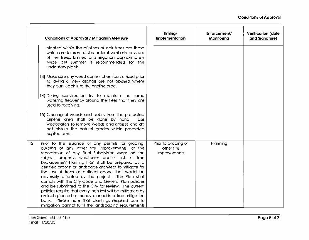
12) Landscaping beneath oak trees may include nonplant materials such as bark mulch, wood chips,boulders, etc. The only plant species that shall be
The Shires (EG-03-418)Final 11/20/03
TIming/Implementation
Enforcement/Monitoring
Conditions of Approval
Verification (dateand Signature)
Page 7 of 21
Conditions of Approval/Mitigation Measure
planted within the driplines of oak trees are thosewhich are tolerant of the natural semi-arid environsof the trees. Limited drip irrigation approximatelytwice per summer is recommended for theunderstory plants.
13) Make sure any weed control chemicals utilized priorto laying of new asphalt are not applied wherethey can leach into the dripline area.
14) During construction try to maintain the samewatering frequency around the trees that they areused to receiving.
15) Clearing of weeds and debris from the protecteddripline area shall be done by hand. Useweedeaters to remove weeds and grasses and donot disturb the natural grades within protecteddripline area.
12. I Prior to the issuance of any permits for grading.building or any other site improvements, or therecordation of any Final Subdivision Maps on thesubject property, whichever occurs first. a TreeReplacement Planting Plan shall be prepared by acertified arborist or landscape architect to mitigate forthe loss of trees as defined above that would beadversely affected by the project. The Plan shallcomply with the City Code and General Plan policiesand be submitted to the City for review. The currentpolicies require that every inch lost will be mitigated byan inch planted or money placed in a tree mitigationbank. Please note that plantings required due tornitiqofion cannot fulfill the londscopinq requirements
The Shires (EG-03-418)Final 11/20/03
Timing/Implementation
Prior to Grading orother site
Improvements
Enforcement/Monitoring
Planning
Conditions of Approval
Verification (dateand Signature)
Page 8 of 21

Conditions of Approval / Mnigation Measure
of the City's Design Guidelines. The Plan shall includethe following elements:
1) Species, size and location of all replacementplantings;
2) Method of irrigation:
3) The City of Elk Grove Standard Tree Planting Detaill-I. including the lO-foot depth boring hole toprovide for adequate drainage:
4) Planting, irrigation and maintenance schedules:
5) Identify the maintenance entity and include theirwritten agreement to provide care and irrigation ofthe trees for a 3-year establishment period, and toreplace any of the replacement oak trees whichdo not survive that period;
6) The minimum spacing for replacement oak treesshall be 20 feet on center;
7) Replacement oak trees shall not be planted within15 feet of the driplines of existing oak trees to beretained on-site, or within 15 feet of a buildingfoundation or swimming pool excavation;
8) No vehicles, construction equipment, mobilehome/office, supplies, materials or facilities shall bedriven, parked, stockpiled or located within thedriplines of oak trees;
9) No grading (grade cuts or fills) shall be allowed
The Shires (EG-03-418)Final 11/20/03
Timing/Implementation
Enforcement/Monitoring
Conditions of Approval
Verification (dateand Signature)
Page 9 of 21

Conditions of Approval I Mitigation Measure
within the driplines of the oak trees;
10) Drainage patterns on the site shall not be modifiedso that water collects or stands within, or is divertedacross, the dripline of any oak tree;
11) No trenching shall be allowed within the dripline ofoak trees. If it is absolutely necessary to installunderground utilities within the dripline of an oaktree, the utility line shall be bored or jacked underthe supervision of a certified orborist:
12) The construction of impervious surfaces within thedriplines of oak trees shall be stringently minimized.When it is absolutely necessary, a piped aerationsystem per City standard detail shall be installedunder the supervision of a certified arborist;
13) No sprinkler or irrigation system shall be installed insuch a manner that sprays water or requirestrenching within the driplines of oak trees. Anabove ground drip irrigation system isrecommended;
14) Landscaping beneath oak trees may include nonplant materials such as bark mulch, wood chips,boulders, etc. The only plant species that shall beplanted within the driplines of oak trees are thosethat are tolerant of the natural. semi-arid environsof the trees. Limited drip irrigation approximatelytwice per summer is recommended for theunderstory plants.
13. I Provide calculation for the pipe capacity inconformance with the 1996 Hydrology Standards
The Shires (EG-03-418)Final 11/20/03
....
Timing/Implementation
Improvement Plans
Enforcement/Monitoring
Public Works
Conditions of Approval
Verification (dateand Signature)
Page 10of21

Conditions of Approval
Timing/ Enforcement/ Verification (dateConditions of Approval I Mitigation Measure Implementation Monitoring and Signature)
Volume II and City of Elk Grove ImprovementStandards.
14. Install on-site and off-site drainage facilities as required Grading Permit and/or Public Workspursuant to the Sacramento County Floodplain deemed needed byManagement Ordinance, and the City of Elk Grove Public WorksImprovement Standards, including any fee required bythe Sacramento County Water Agency.
15. The SACPRE methodology as contained in the 1996 Improvement Plans Public WorksHydrology Standards Volume 2 shall be used tocalculate the 100year runoff
16. Indicate the location of Bader Road and the triple 29" Improvement Plans Public Worksx 48" CMP arch culvert on the drainage area map.
17. Provide the hydraulic calculations indicating how the Improvement Plans Public Works100-year HGL elevation of 64.5' was arrived at. Thesecalculations must take in consideration the existingculverts and the new channel proposed to handle thepeak runoff.
18. Provide water surface calculations for the 10 and 100- Improvement Plans Public Worksyear frequency flows for existing and proposed,increased flows.
19. Indicate how access through lots 6 and 7 will be Improvement Plans Public Worksprovided to the modified drainage channel. Should itbe culverts or bridges, please take the effect inconsideration throughout the hydraulic calculations.
20. About 30% of the proposed development will drain Improvement Plans Public Workstoward Bond Road. Demonstrate the resulting flowsbe handled.
21. Lot 8 will include an additional detention basin to Improvement Plans Public Workscapture additional water flows
22. The minimum radius of curvature on a 40 foot street Improvement Plans Public Worksshall be 200'.
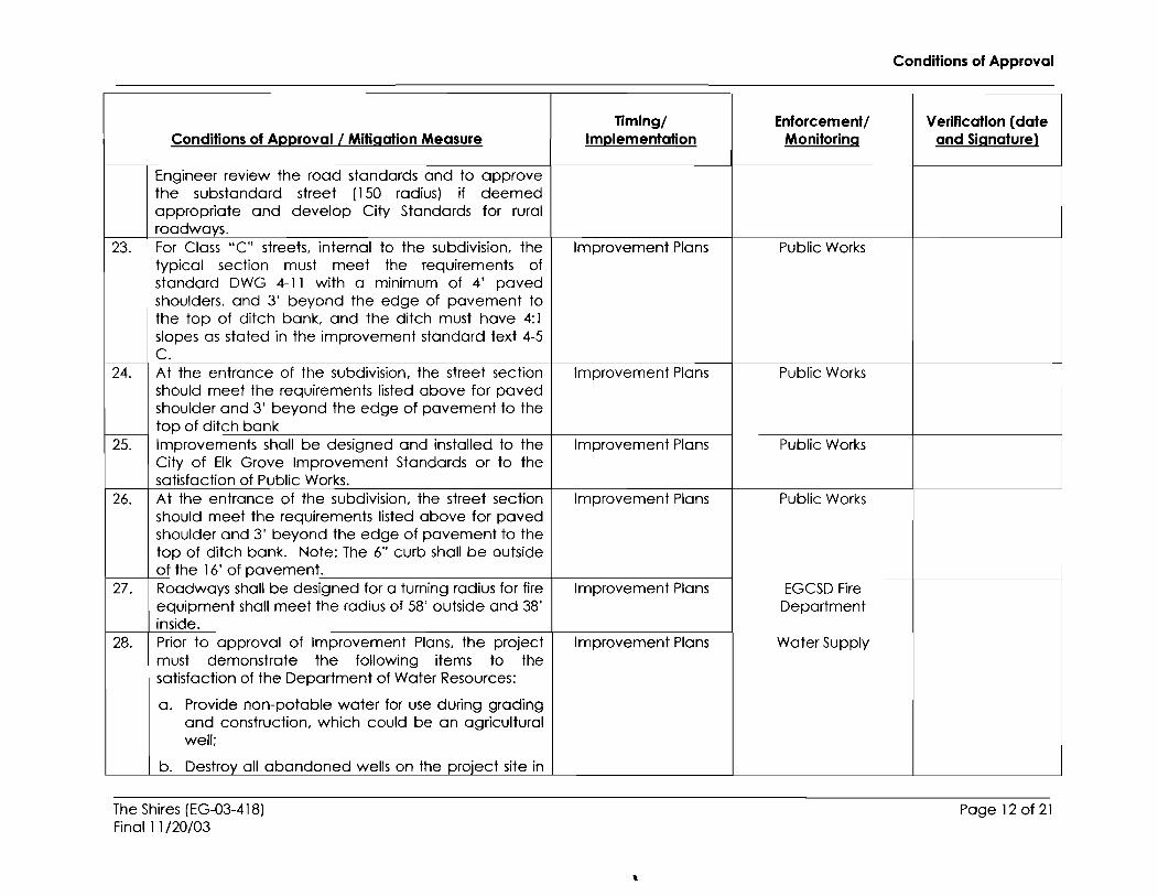
The Plonninq Commission has requested that the City
The Shires (EG-03-418)Final 11/20/03
Page 11 of 21
Conditions of Approval
TIming/ Enforcement/ Verification (dateConditions of Approval/Mitigation Measure Implementation Monitoring and Signature)
Engineer review the road standards and to approvethe substandard street (150 radius) if deemedappropriate and develop City Standards for ruralroadways.
23. For Class "C" streets, internal to the subdivision, the Improvement Plans Public Workstypical section must meet the requirements ofstandard DWG 4-1 1 with a minimum of 4' pavedshoulders, and 3' beyond the edge of pavement tothe top of ditch bank, and the ditch must have 4:1slopes as stated in the improvement standard text 4-5C.
24. At the entrance of the subdivision, the street section Improvement Plans Public Worksshould meet the requirements listed above for pavedshoulder and 3' beyond the edge of pavement to thetop of ditch bank
25. Improvements shall be designed and installed to the Improvement Plans Public WorksCity of Elk Grove Improvement Standards or to thesatisfaction of Public Works.
26. At the entrance of the subdivision, the street section Improvement Plans Public Worksshould meet the requirements listed above for pavedshoulder and 3' beyond the edge of pavement to thetop of ditch bank. Note: The 6" curb shall be outsideof the 16' of pavement.
27. Roadways shall be designed for a turning radius for fire Improvement Plans EGCSD Fireequipment shall meet the radius of 58' outside and 38' Departmentinside.
28. Prior to approval of Improvement Plans, the project Improvement Plans Water Supplymust demonstrate the following items to thesatisfaction of the Department of Water Resources:
a. Provide non-potable water for use during gradingand construction, which could be an agriculturalwell;
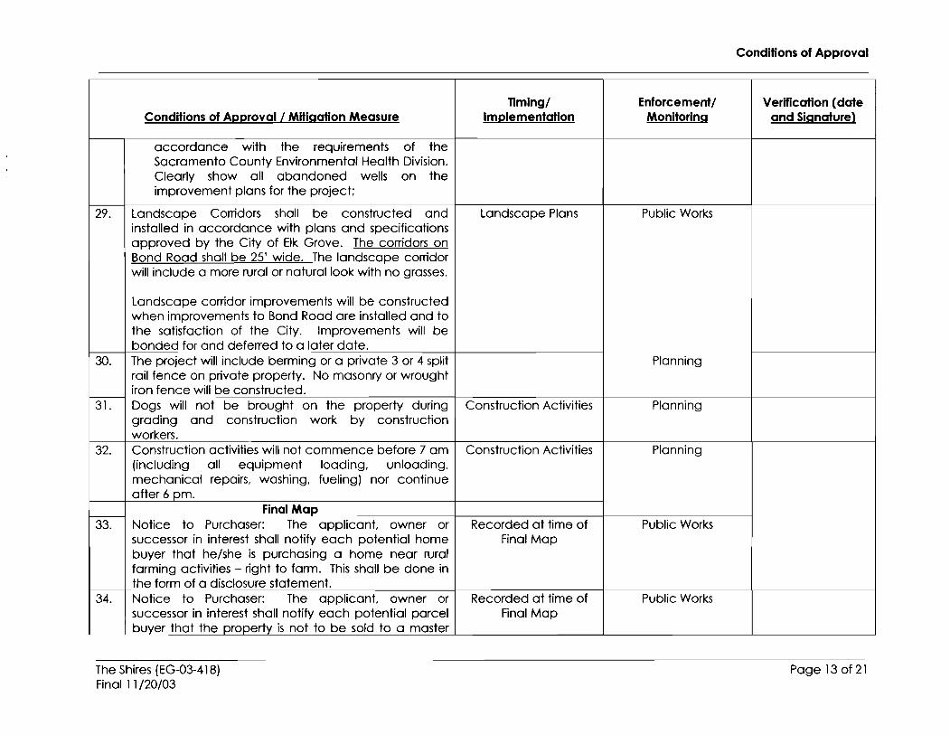
b. Destroy all abandoned wells on the project site in
The Shires (EG-03-418)Final 11/20/03
~
Page 12 of 21
Conditions of Approval
Tlmlng/ Enforcement/ Verification (dateConditions of Approval/Mitigation Measure Implementation Monitoring and Signature)
accordance with the requirements of theSacramento County Environmental Health Division.Clearly show all abandoned wells on theimprovement plans for the project;
29. Landscape Corridors shall be constructed and Landscape Plans Public Worksinstalled in accordance with plans and specificationsapproved by the City of Elk Grove. The corridors onBond Road shall be 25' wide. The landscape corridorwill include a more rural or natural look with no grasses.
Landscape corridor improvements will be constructedwhen improvements to Bond Road are installed and tothe satisfaction of the City. Improvements will bebonded for and deferred to a later date.
30. The project will include berming or a private 3 or 4 split Planningrail fence on private property. No masonry or wroughtiron fence will be constructed.
31. Dogs will not be brought on the property during Construction Activities Planninggrading and construction work by constructionworkers.
32. Construction activities will not commence before 7 am Construction Activities Planning(including all equipment loading, unloading,mechanical repairs, washing, fueling) nor continueafter 6 pm.
FinalMap33. Notice to Purchaser: The applicant, owner or Recorded at time of Public Works
successor in interest shall notify each potential home Final Mapbuyer that he/she is purchasing a home near ruralfarming activities - right to farm. This shall be done inthe form of a disclosure statement.
34. Notice to Purchaser: The applicant, owner or Recorded at time of Public Workssuccessor in interest shall notify each potential parcel Final Mapbuyer that the property is not to be sold to a master
The Shires (EG-03-418)Final 11/20/03
Page 13 of 21
Conditions of Approval
Timing/ Enforcement! Verification (dateConditions of Approval/Mitigation Measure Implementation Monitoring and Signature)
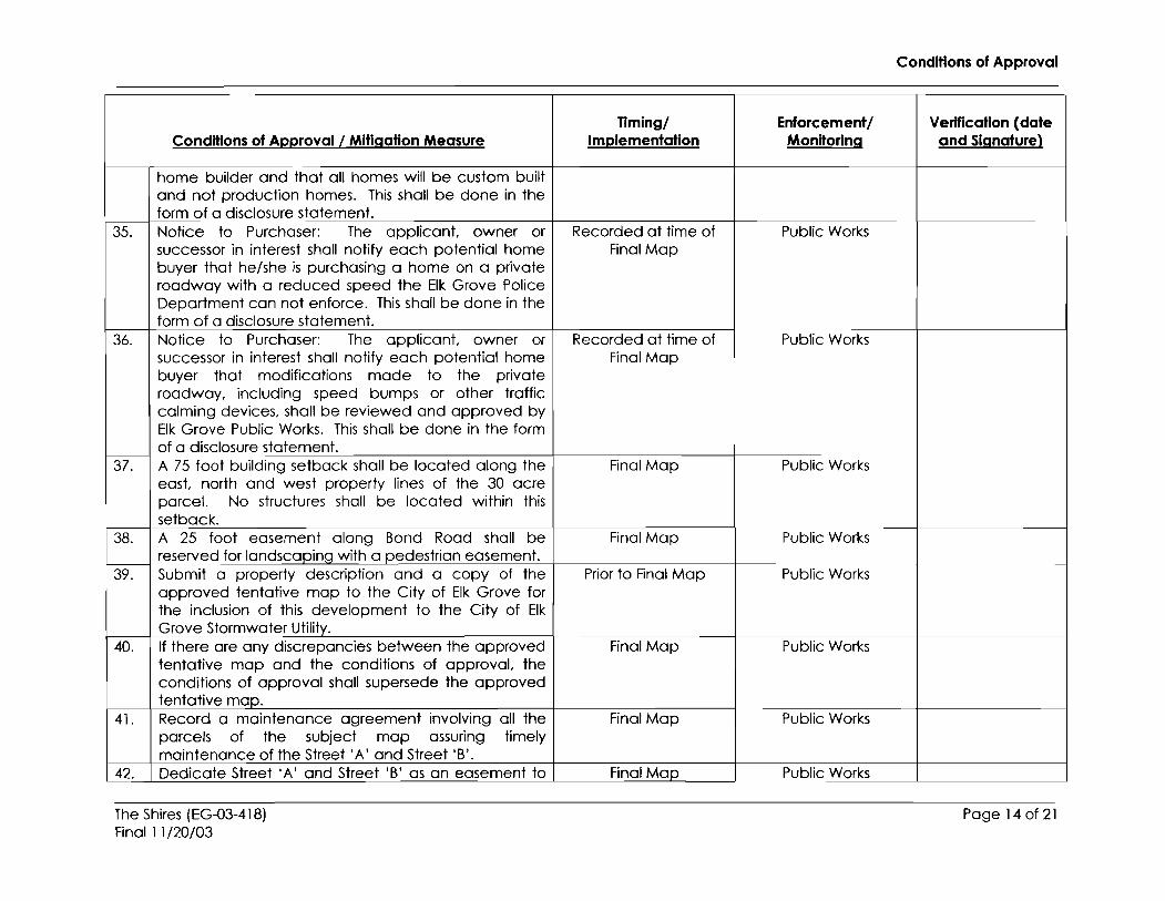
home builder and that all homes will be custom builtand not production homes. This shall be done in theform of a disclosure statement.
35. Notice to Purchaser: The applicant, owner or Recorded at time of Public Workssuccessor in interest shall notify each potential home Final Mapbuyer that he/she is purchasing a home on a privateroadway with a reduced speed the Elk Grove PoliceDepartment can not enforce. This shall be done in theform of a disclosure statement.
36. Notice to Purchaser: The applicant, owner or Recorded at time of Public Workssuccessor in interest shall notify each potential home Final Mapbuyer that modifications made to the privateroadway, including speed bumps or other trafficcalming devices, shall be reviewed and approved byElk Grove Public Works. This shall be done in the formof a disclosure statement.
37. A 75 foot building setback shall be located along the Final Map Public Workseast, north and west property lines of the 30 acreparcel. No structures shall be located within thissetback.
38. A 25 foot easement along Bond Road shall be Final Map Public Worksreserved for londscopinq with a pedestrian easement.
39. Submit a property description and a copy of the Prior to Final Map Public Worksapproved tentative map to the City of Elk Grove forthe inclusion of this development to the City of ElkGrove Stormwater Utility.
40. If there are any discrepancies between the approved Final Map Public Workstentative map and the conditions of approval, theconditions of approval shall supersede the approvedtentative map.
41. Record a maintenance agreement involving all the Final Map Public Worksparcels of the subject map assuring timelymaintenance of the Street I A' and Street I B'.
42. Dedicate Street lA' and Street IB' as an easement to Final Map Public Works
The Shires (EG-03-418)Final 11/20/03
Page 14 of 21
Conditions of Approval
TImlng/ Enforcement/ Verification (dateConditions of Approval/Mitigation Measure Implementation Monitoring and Signature)
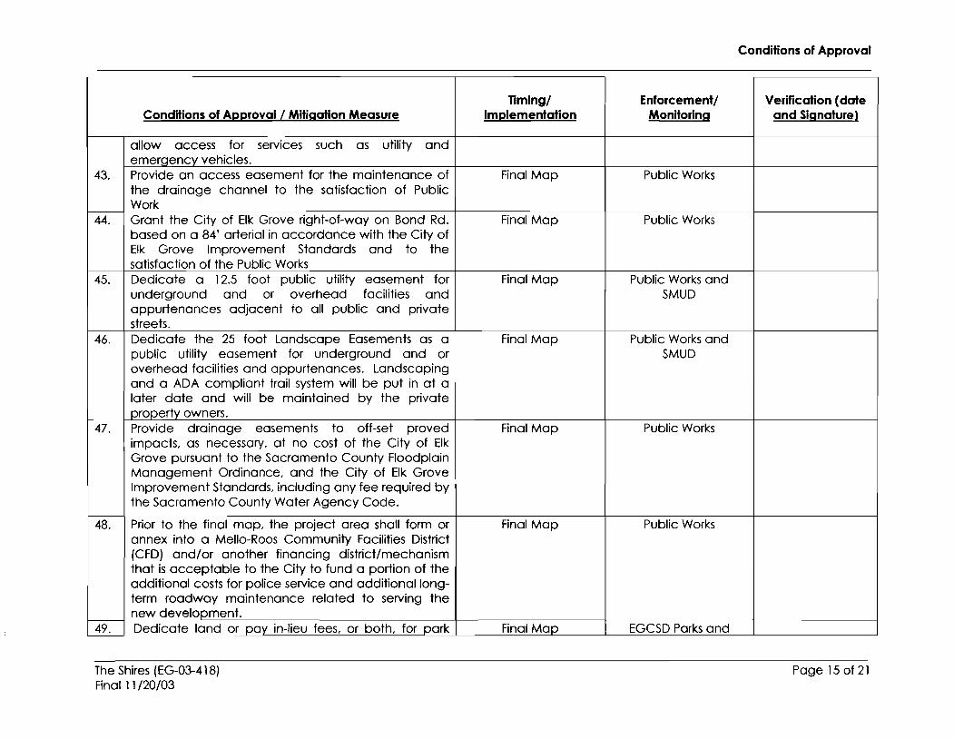
allow access for services such as utility anderneroencv vehicles.
43. Provide an access easement for the maintenance of Final Map Public Worksthe drainage channel to the satisfaction of PublicWork
44. Grant the City of Elk Grove right-of-way on Bond Rd. Final Map Public Worksbased on a 84' arterial in accordance with the City ofElk Grove Improvement Standards and to thesatisfaction of the Public Works
45. Dedicate a 12.5 foot public utility easement for Final Map Public Works andunderground and or overhead facilities and SMUDappurtenances adjacent to all public and privatestreets.
46. Dedicate the 25 foot Landscape Easements as a Final Map Public Works andpublic utility easement for underground and or SMUDoverhead facilities and appurtenances. Landscapingand a ADA compliant trail system will be put in at alater date and will be maintained by the privateproperty owners.
47. Provide drainage easements to off-set proved Final Map Public Worksimpacts, as necessary, at no cost of the City of ElkGrove pursuant to the Sacramento County FloodplainManagement Ordinance, and the City of Elk GroveImprovement Standards, including any fee required bythe Sacramento County Water Agency Code.
48. Prior to the final map, the project area shall form or Final Map Public Worksannex into a Mello-Roes Community Facilities District(CFD) and/or another financing district/mechanismthat is acceptable to the City to fund a portion of theadditional costs for police service and additional long-term roadway maintenance related to serving thenew development.
49. Dedicate land or pay in-lieu fees, or both. for park Final Map EGCSD Parks and
The Shires (EG-03-418)Final 11/20/03
Page 15 of 21
Conditions of Approval
TIming/ Enforcement/ Verification (dateConditions of Approval I Mitigation Measure Implementation Monitoring and Signature)
purposes, as required by and in accordance with the Recreation and Publicstandards set forth in Chapter 22.40, Title 22 of the City Worksof Elk Grove Code.
50. Prior to the recordation of the Final Map the applicant Final Map CSD-lwill enter into and record an agreement, in a formapproved by the District Engineer and District Counselof Sacramento Regional County Sanitation District, torequire the property owner(s) to reserve lands foracquisition by the District to install District pipelines andfacilities for public health purposes and inconformance with the District Masterplan(approximately 60 feet wide past the limit of EGCSD).The landscape strip for EGCSD shall be granted as aneasement to SRCSD in addition to the aboverequirement. The District shall exercise the agreementand acquire the reserved lands within two years of thecompletion and acceptance of required publicimprovements.
51. A 25 foot landscape easement shall be located along Final Map Planningthe east. north and west boundaries of the existing 30acre parcel. No structures shall be built in thiseasement. The landscape easement will be plantedwith trees, shrubs and grasses to create a year roundprivacy screen.
Building Permit52. The landscape corridor on lots 2 and 3 shall be Building Permit Planning
planted prior to building construction tokino place.53. Install public street improvements on Bond Rd. based Prior to 151 Building Public Works
on a 84' arterial in accordance with the City of Elk PermitGrove Improvement Standards and to the satisfactionof the Public Works.
54. The floor elevation must be a minimum of 1 foot Building Permit Public Worksabove the 1OO-year water level for the area.
55. Prior to the issuance of buildinq permits, the property Bulldinq Permit Public Works
The Shires (EG-03-418)Final 11/20/03
Page 16 of 21

Conditions of Approval
TImlng/ Enforcement/ Verification (dateConditions of Approval/Mitigation Measure Implementation Monitoring and Signature)
owner shall pay development impact fees inaccordance with the Elk Grove / West Vineyard PublicFacilities Financing Plan Development Impact FeeProgram and Chapter 16.82 of the Elk Grove MunicipalCode, including any authorized adjustments andupdates thereto.
56. The project will not include a private gate at the Building Permit Public Worksentrance of A Drive.
57. Individual septic systems for the project will be Building Permits EMDapproved by the County Environmental ManagementDepartment. (EMDI
58. A percolation test to determine suitability and design Building Permits EMDfor individual septic systems will be done andapplication made to Environmental Health for apermit. (EMDI
59. All homes in this development will be required to be Building Permits EGCSD Firefire sorinklered. Department
60. Public Works shall review and approve the driveway Improvement Plans Public Workslocation for lots 1 and 10.
61. Private water wells will be designed and application Building Permits EMDmade to Environmental Health for a permit. (EMDI
62. A 5 foot high no climb fence will be installed along the Building Permit Planningeastern property line of the 30 acre property. Alongthe northern and western property lines fencing will becqreed to by the property owners.
63. One primary single family residence with the option for Building Permit Planninga 1200 square foot secondary dwelling unit will beallowed per property in accordance with the ZoningCode and State law.
64. The Shires will be responsible for weed control and the On-Going Planning and EGCSDroutine maintenance and plant replacement for the Fire25 foot landscape corridor.
65. A private roadway sign shall be placed at the Improvement Plans Public Worksentrance to the Shires proiect.
The Shires (EG-03-418)Final 11/20/03
..
Page 17 of 21

Conditions of Approval
Timing/ Enforcement/ Verification (dateConditions of Approval I Mitigation Measure Implementation Monitoring and Signature)
Prior to Occupancy66. The individual landscaping corridor along lots 4,5,6 Prior to Occupancy Planning
and 7 shall be completed prior to residentialoccupancy on each parcel.
The Shires (EG-03-418)Final 11/20/03
Page 18 of 21

Conditions of Approval
General Compliance Items for Building Permit
1. Prior to issuance of bUilding permits, the project developer/owner shall pay Zone 40development fees applicable at the time of building permit issuance in accordance withSacramento County Water Agency Ordinance No. 18. (Water Supply)
2. Prior to issuance of building permits, the project shall conform to the specific provisions of theCity's Landscape Water Conservation Ordinance (Chapter 14.10of the City of Elk Grove Code)to the satisfaction of the City's plan checker or consultant. (Water Supply)
3. Secure approval of a civil engineered site improvement plan for all proposed on-site and offsite improvements.
4. Permits and/or fees are required for the following reviews: civil plans, architectural plans, firesprinkler plans and fire alarm plans. Additional permits and fees may apply depending upon thescope of the project.
7. Dead-end streets in excess of 150feet require emergency vehicle turn-a-rounds.
8. Any and all gates impeding fire lanes or roadways shall comply with Appendix VII of the 2002Sacramento County Fire Code.
9. If homes exceeding 3,600 square feet (including garages and covered porches) will be built inthis subdivision, additional fire flow analysis of the water system must be conducted. Singlefamily dwellings 3,601 square feet to 4,800 square feet require 1,750 gpm and homes 4,801square feet to 6,200 square feet require 2,000 gpm.
10. An approved automatic fire sprinkler system shall be installed within all new R-3 occupancieswhen the total floor area (area under roof including garages and attached solid roof canopies)exceeds 5,999 square feet and/or the total livable area (area not including garages andattached solid roof canopies) exceeds 4, 999 square feet.
11. As of February 1, 2003, all contractors for single-family homes and duplexes (R-3 Occupancies)shall provide an option for residential fire sprinklers. Prior to the prospective buyer signing a salescontract, the contractor or their agent shall obtain from the Fire Department an informationalpacket containing educational materials approved by the Fire Department, including a formexplaining the option for residential sprinklers. The contractor or their agent shall provide theapproved informational packet to any and all prospective buyers and require the execution ofa signed receipt for the educational material from the prospective buyer. The contractor shallinstall residential fire sprinklers upon the request and execution of a purchase agreement by thehomebuyer. Fire sprinkler systems for single-family homes and duplexes shall be designed andinstalled to not less than the minimum requirements contained in NFPA 13D, 1996 edition.
12. All civil engineering plans are required to be submitted in an electronic format. When plan isready for final signature, it is required that the engineering firm will submit an electronic copy ofthe complete plan as it appears in the approved printed plans with addresses. All electronicformats will be submitted on Windows/DOS formatted diskettes, zip disks or on compact disk(CD). E-mailed copies will not be accepted at this time. Electronic formats can be submitted ineither of the following data transfer formats listed below:
DFX (Drawing Interchange file) release 2002 or previousDWG (Applies to AUOCAD drawing file) release 2002 or previous
The Shires(EG-03-418)Final 11/20/03
Page 19 of 21
Conditions of Approval
13. Addresses for all lots shall be provided to the Fire Department within sixty (60) days of FireDepartment signature of approval for development plans.
14. No more than 40 building permits shall be issued when a single point of access exists for asubdivision. Since there is no process in place for confirming the sequence in which the unitsare built. the above information should be considered and the Elk Grove CSD Fire Departmentshould be consulted on this matter.
15. All commercial buildings, in excess of 3,599 square feet shall be equipped with an approvedautomatic fire sprinkler system.
16. Commercial developments in excess of 10,000 square feet require looped fire mains of aminimum of ten- (10) inch diameter to supply fire hydrants spaced at a maximum of 300-footintervals. This on-site fire main shall be connected to the municipal water main at not less thantwo (2) points.
17. This development is required to provide fire flow from a public water system capable ofdelivering at a minimum 50 PSI static pressure and 3,000 GPM at 20 PSI residual pressure incommercial areas and 50 PSI static pressure and 1,000 GPM at 20 PSI residual pressure inresidential, single-family home areas. Buildings of certain types of construction, size, and usemay need additional fire flow or the application of mitigating efforts to meet fire flows abovethis minimum.
18. All required roadways, street signs, addresses, water mains, fire hydrants, and fire flows shall beprovided prior to the existence of any combustible construction or storage. The slope of accessroadways shall not exceed 10% for asphalt and 15 % for concrete. The roadways shall beconstructed to a 20-foot minimum width with a minimum of three (3) inches AC over six (6)inches AB with good drainage.
19. Traffic pre-emption devices of a typed approved by the Elk Grove Fire Department. shall beinstalled on all traffic signal devices erected or modified by this development. These devicesshall be installed and functioning prior to any occupancy and at no cost to the Elk Grove FireDepartment.
20. Required fire alarm systems [other than single family dwellings) shall be connected to a UL listedcentral station approved by the Sacramento County Regional Communications Center.
21. Permits and/or fees are required for the following plan reviews: site plan, architectural plan, firesprinkler plan, fire alarm plan, and special extinguishing plans.
22. The installation of on-site or off-site fire protection equipment including fire hydrants and watermains shall meet the standards of the Elk Grove Fire Department and the water purveyor havingjurisdiction.
23. The installation of roadway gates, addresses, landscaping, pipe bollards, fuel tanks, masonrysound walls, tree wells, and/or traffic calming devices are subject to standards outlined by theElk Grove Fire Department.
24. The wetlands/riparian corridors of creeks create an unusual fire hazard and challenge toemergency responders. The following requirements apply:
The Shires(EG-03-418)Final 11/20/03
Page 20 of 21

Conditions of Approval
A. Provide non-combustible fences along all developed areas adjacent to wetlands,creeks, or open spaces.
B. Provide access to all wetland corridors at the end of cul-de-sacs via rolled curbs andgates with pipe bollards. Bike lanes adjacent to creeks shall be a minimum of 10feet wide with a turning radius of not less than 35 feet inside and 45 feet outsidediameters.
C. Any bridges over creeks or wetland areas shall be capable of supporting 65,000GVW.
D. Provide at least ten (10) feet of greenbelt or other defensible space between noncombustible fences and the creek/wetlands area.
The Shires [EG-03-418)Final 11/20/03
Page 21 of 21