california - ci.oakley.ca.us · tpm 02-16 may 24,2016 page 3 of3 general plan required by law. when...
TRANSCRIPT
OAKLEY -~-CALIFORNIA
Date: May 24, 2016
To: Bryan Montgomery, City Manager
From: Joshua McMurray, Planning Manager
Agenda Date: 05/24/2016 Agenda Item: 4.2
STAFF REPORT
SUBJECT: Hamman Minor Subdivision MS 16-977 (Tentative Parcel Map TPM 02-
SUMMARY
16) - A Request to subdivide 3.96-acre parcel into two lots with a remainder parcel located at 2540 Oakley Road APN: 037-080-021
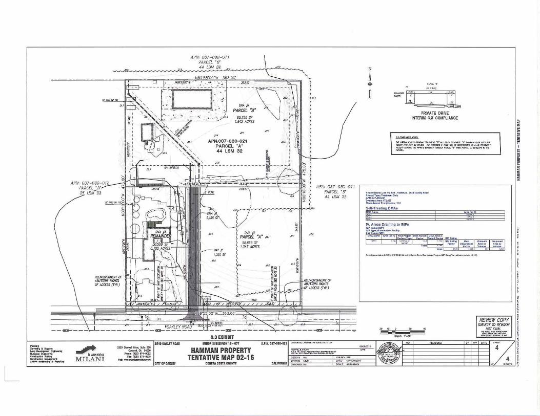
This is a public hearing on a request for approval of a Tentative Parcel Map (TPM 02-16) to subdivide 3.96-acre parcel into two lots with a remainder parcel. Parcel A will be 1.347-acres, Parcel B will be 1.842-acres and the Remainder Parcel will be .702-acres. No construction is proposed at this time. The legal non-conforming single-family residential dwelling will remain on a proposed remainder parcel. The site is located at 2540 Oakley Road and is designated as Light Industrial in the Oakley 2020 General Plan and zoned Light Industrial (LI) District.
Staff recommends the City Council adopt the resolution approving the Hamman Minor Subdivision MS 16-977 (Tentative Parcel Map TPM 02-16), as conditioned.
BACKGROUND
General Plan and Zoning
The General Plan Land Use Designation for the project site is Industrial as depicted in the Oakley 2020 General Plan Figure 2-2 (Land Use Diagram). The site is zoned "LI" (Light Industrial) District. Applicable lot requirements for the Ll District include a 7,500 square foot minimum lot size, 0.67 maximum base floor area ratio (FAR), 50% maximum lot coverage, and no applicable minimum lot width or lot depth.
Existing Conditions and Surrounding Uses
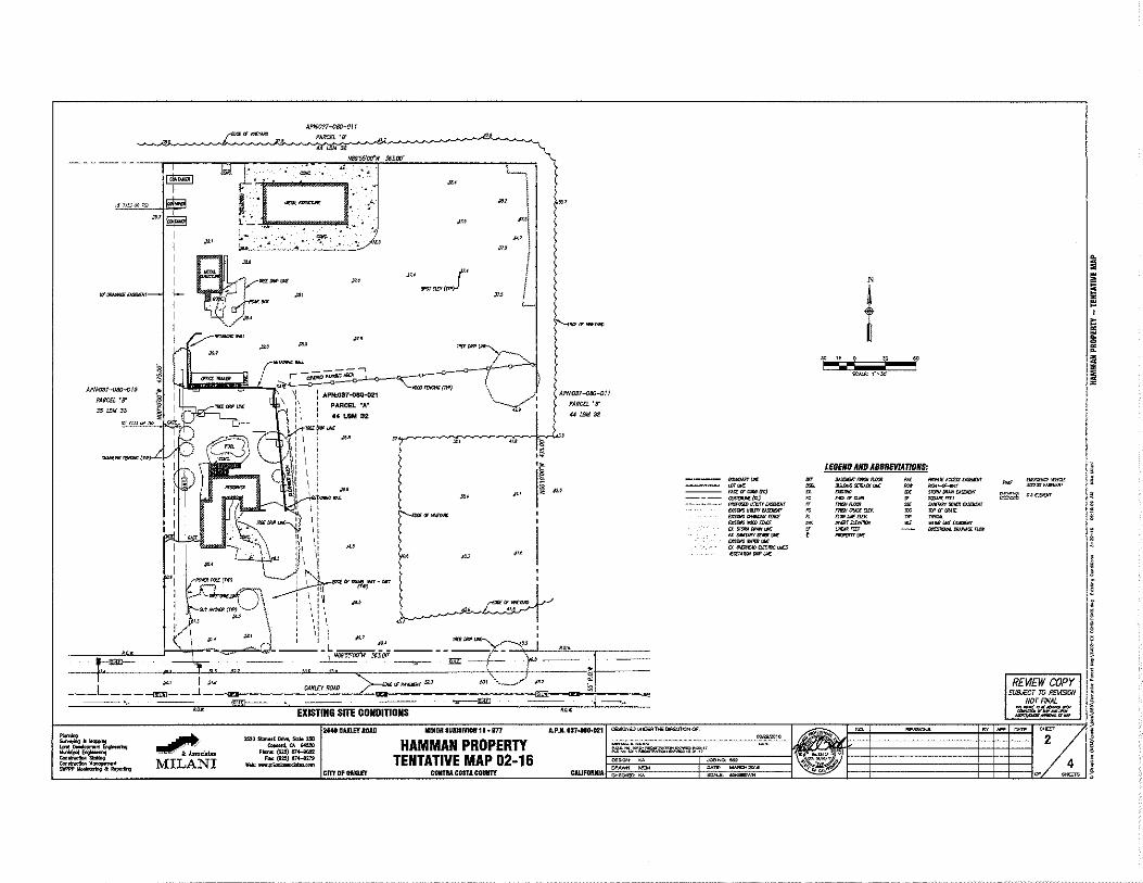
Project Site: The project site at 2540 Oakley Road is 3.96-acres and currently has one single-family home and several accessory structures.
North: A vineyard exists to the north on land designated and zoned for Light industrial uses.
TPM 02-16 May 24,2016 Page 2 of3
South: Land designated and zoned for Single-Family Residential uses exist to the south of the project site, across Oakley Road.
East: A vineyard exists to the east on land designated and zoned for Light industrial uses.
West: Continente Nut exists to the west on land designated and zoned for Light industrial uses.
PROJECT DESCRIPTION
Tentative Parcel Map
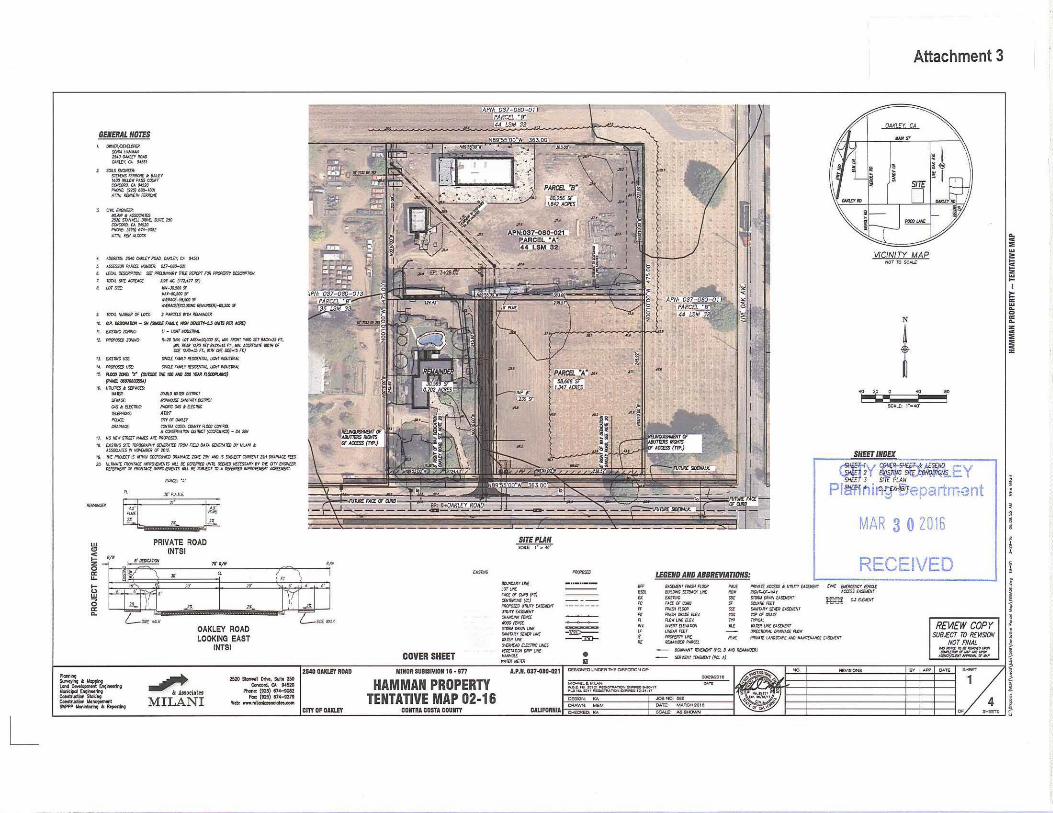
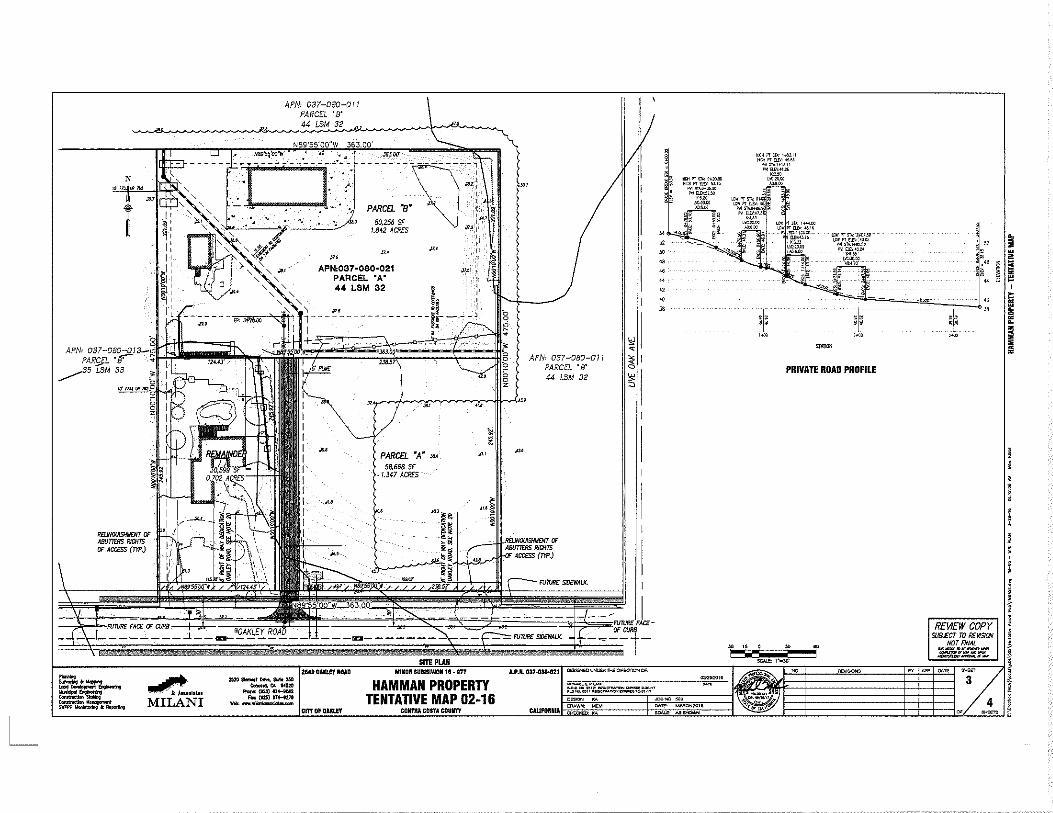
The proposed tentative parcel map (MS 16-977) does not include plans for development at this time. The purpose of the project is to subdivide existing parcel into two lots, with a remainder lot, so that the two new lots can be sold and developed at some time in the future. If approved, the subdivision would result in two parcels; Parcel A at 58,668 square feet (1.347-acres), and Parcel Bat 80,256 square feet (1.842-acres). The remainder parcel would be 30,599 square feet (0.702-acres).
The project site is accessed from Oakley Road and the applicant has proposed a 30 foot wide access easement (20 feet of pavement and 5' feet of landscaping on both sides) to provide access to the two new parcels and remainder parcel. The project has been conditioned to dedicate an 8 foot deep section of the project frontage and construct improvements to Oakley Road consisting of curb, gutter, sidewalk, landscaping and street lights.
ENVIRONMENTAL REVIEW
The proposed project is exempt from the requirements of the California Environmental Quality Act (CEQA) pursuant to Section 15315 (Class 15- Minor Land Divisions) of the State CEQA Guidelines. This project can be classified as Class 15 in that:
• The project is a division of land, in an urbanized area zoned for industrial use, into four or fewer parcels;
• The division is in conformance with the General Plan and zoning ordinance, and no variances or exceptions are required; and
• All services and access to the proposed parcels to local standards are available, and the parcel was not involved in a larger subdivision within the last two years.
REQUIRED FINDINGS
The tentative parcel map was analyzed in relation to the required findings found in the City's subdivision ordinance (adopted County ordinance by reference), which generally state, "the City Council shall not approve a tentative map unless it finds that the proposed subdivision, together with the provisions for its design and improvement, is consistent with the applicable
TPM 02-16 May 24,2016 Page 3 of3
general plan required by law. When approving the tentative map for a minor subdivision, the advisory agency shall make findings as required concerning the fulfillment of construction requirements." The proposed parcels must also comply with the regulations set forth in the Light Industrial "LI" District.
ANALYSIS AND FINDINGS
The main purpose of the subdivision is to subdivide the land in order to sell the two parcels being created. The proposed tentative parcel map represents a subdivision of land that is consistent with the applicable General Plan policies and guidelines in that it brings the project site into further conformance by allowing additional Light Industrial lots to be created that have future development potential.
From a zoning perspective, the lot sizes are consistent with the applicable Ll District zoning regulations of 7,500 square foot minimum lot sizes. No development is proposed at this time. Any development on the future lots would require at a minimum a Design Review approval for the site development and building design.
FINDINGS
Complete draft findings are included in the attached resolution.
RECOMMENDATION
Staff recommends the City Council adopt the resolution approving the Hamman Minor Subdivision MS 16-977 (Tentative Parcel Map TPM 02-16), as conditioned.
ATTACHMENTS
1. Vicinity Map 2. Public Hearing Notice 3. Applicant's Plans 4. Draft Resolution
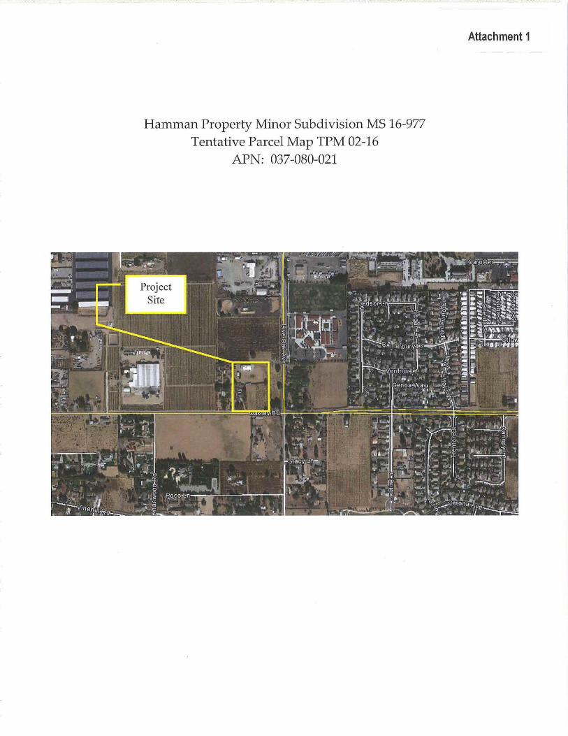
Hamman Property Minor Subdivision MS 16-977 Tentative Parcel Map TPM 02-16
APN: 037-080-021
Attachment 1
OAKLEY -~-CALIFORNIA
Attachment 2
City of Oakley 3231 Main Street
Oakley, CA 94561 www .oakleyinfo.com
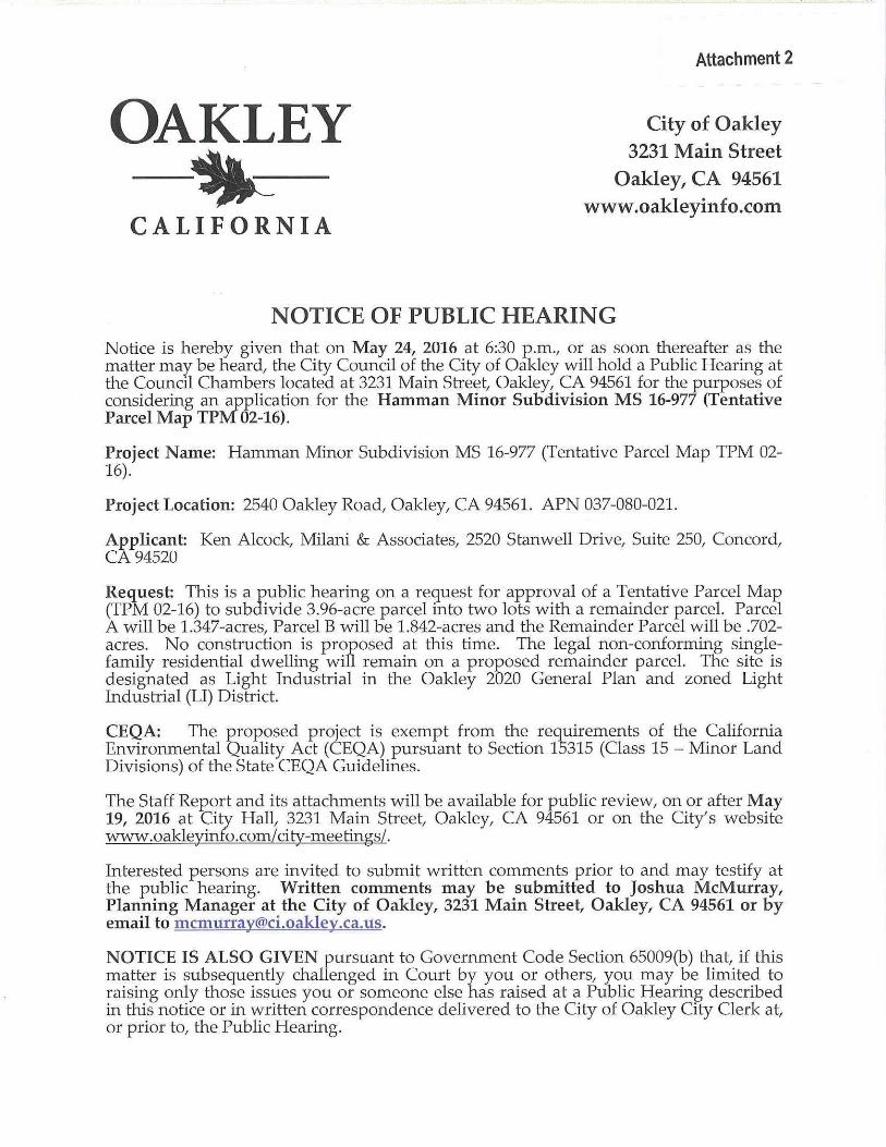
NOTICE OF PUBLIC HEARING Notice is hereby given that on May 24, 2016 at 6:30 p.m., or as soon thereafter as the matter may be heard, the City Council of the City of Oakley will hold a Public Hearing at the Council Chambers located at 3231 Main Street, Oakley, CA 94561 for the purposes of considering an application for the Hamman Minor Subdivision MS 16-977 (Tentative Parcel Map TPM 02-16).
Project Name: Hamman Minor Subdivision MS 16-977 (Tentative Parcel Map TPM 02-16).
Project Location: 2540 Oakley Road, Oakley, CA 94561. APN 037-080-021 .
Applicant: Ken Alcock, Milani & Associates, 2520 Stanwell Drive, Suite 250, Concord, CA 94520
Request: This is a public hearing on a request for approval of a Tentative Parcel Map (TPM 02-16) to subdivide 3.96-acre parcel into two lots with a remainder parcel. Parcel A will be 1.347-acres, Parcel B will be 1.842-acres and the Remainder Parcel will be .702-acres. No construction is proposed at this time. The legal non-conforming singlefamily residential dwelling will remain on a proposed remainder parcel. The site is designated as Light Industrial in the Oakley 2020 General Plan and zoned Light Industrial (LI) District.
CEQA: The proposed project is exempt from the requirements of the California Environmental Quality Act (CEQA) pursuant to Section 15315 (Class 15- Minor Land Divisions) of the State CEQA Guidelines.
The Staff Report and its attachments will be available for public review, on or after May 19, 2016 at City Hall, 3231 Main Street, Oakley, CA 94561 or on the City's website www .oakleyinfo.com/ city-meetings/.
Interested persons are invited to submit written comments prior to and may testify at the public hearing. Written comments may be submitted to Joshua McMurray, Planning Manager at the City of Oakley, 3231 Main Street, Oakley, CA 94561 or by email to mcmurray®ci.oakley.ca.us.
NOTICE IS ALSO GIVEN pursuant to Government Code Section 65009(b) that, if this matter is subsequently challenged in Court by you or others, you may be limited to raising only those issues you or someone else has raised at a Public Hearing described in this notice or in written correspondence delivered to the City of Oakley City Clerk at, or prior to, the Public Hearing.
L
GENERAL NOTES
'· 0~09 --2SI!ICIMI'....,.R!Wl ONQ.!("' m61
2 ""'""""' SmotS mlflOil' .t 84IT lU.O'ai.Cif' PA.S:SQ)(.Ir.' COioCI:)lii).Git•!O'O PfftM:(tn)w.lror A1'11(·11:IN'1(1H~ . '"'~ "'V--I•A$SOCIAIES :Y..IDSTANIIW.OIIII(St.r:l:~ cor.t:tlla,CANi10 """y,.(m)f1•-9Ct2 ArntrrtltN.COOI'
f.~n.taC.OO.O'IIOAQCMI.!r.C.I'H~I
$. ~P.uKXJ..1(161S01:0.V-'*"-C17
.....,,., tw-«<,:IOOV A\ttA«-56,!0:$ A~A&UCOIHJ,5GCV
! IQTAL M.M;D t$ lotS: 1 "MCO.S IIIIH IIDI.U.CO
111 c:J!.tf:SOt.4b-$N(!HQ;.£/Mr,I«'MDOdiTI'-iJIImlaAOII()
lf4D(*i.lCif~DOCI'Sf~lll'(liV!IT'fJ.tl:srt&.IDI'..n~ llf(WlJJfr«<.:rt..&al•"fT*MIIt.ACO!fUJ(.,lJf" !UYolewJStr.•III'MJCt• t'n.l
r•. ~ust> SMU''.ullr~tll)lr~
ri ltOQ:IliKlY (W~~ICXIIIIIJ~~It~ --II, lr.V1C"It!lJt~ ..... '"'""' CASIIEZlCMlCI
""""" """'
triA0 .. 1l)IQS'la("f
~S.WfA.frliS~T
PACimt:ASII!llt'M AT.tT orrrsc.w:rr
£lti.HACE: ~CCISTJ Ct»mJI.CCC:c:otr.IIQ. IICCWSfitYA!i(JVCI$111CT(ct!C1UfiCJJ-C,.2fH
11, HOIIn'srJilr.NA~o~ElJII(Mo:rosm.
II 00~$1E'Itli"'OW'H''"~r.:tlflf0o'/9!1DDAT.I. ~ltll·r~4t AS$0Cl,UES~HI:li£WI!IOI~1011.
11. MI'I!O.CCTISIIJ!olllriCCX1UG~:C:ZOif21HAI(JISM.£CQIIII!9riTnHIJRJJHACE.niS
.x1. t.ll:loU1'[~A(£~.J(IjiS MU.S£CUUI!I£DI.It1X.f££JDH!:~rBYI'IoCOn'CHfJii!EA Cl/DN(Jiral~rMX~I'Sai.I£~1'0AfJ£I'CIIIC~T~
,.~·-~·
JC' P.A!I.t
PRIVATE ROAD INTSI
SITE PIAN ~
LEGEND AND ABBRE'IIATIDNS:
Attachment 3
N
t ~ "'
sc.t.Lt: 1"•<14'
.. I
SHEET INDEX
MAR 3 0 2016
RECEIVED
:;: :E
~
~ .... I i: ffi .. co
"' .. z c :E :E c =
~ I
"rmJ(;RIQ ~ ,P.l~
~ Al'JUJ31-Dil0-QI3 ,-..
PAKCEL"f!' 8 35 !.3M 33 ·;
.O'TrJJCD>Ii2
I
I I
I
I
>I I
I I
I
I
I 'I I I
.. "' J'
SI'OI!lEV(I'II' JI.S L
~·-·
• ~ : APN!087-o8Q-021
:\ : PARCEt. "A"
\\ : 44L8M 32 I !Rfi.IIIPIM -cr"'"" : ~
' .,,8
' ' ' ' ' ' ' ' •.
"
~~
APIW87-D80-DII
PA!/Cn 'fl'
44 tsM 32
jl m -'~ w~ rAC[lT"""/1'0)
~-., """""""11JtrE.ISDI!IIT f>ISIII'CU1llll'EA!DJD<T
-~= --= !XS-MMII.K U$JNfAK'(5£>EJIU£ GIIS!I«!II'>?alf.t£ &r.~a«!I!ICI.m l((tr.llQ'IrJIS'I.I'C
" " • ffl.
• '
N
t K-J " "
SCJ.t.E: 1"~30'
LESEND AND ABBREVIATIONS:
~~
Fm>llil!.ICE w:v. n ... /.JNEan: -~~ ~= ~~
PA< -n:•=£~SEJEHr !iW IIJ(>jt4'-IOlT SOC S!tl!>ID/I.U<£J.SDIDft . -= "" s.Kr>Rt'stli0!£.<Saj(llf
ltf'IY'CI!AIO
~ -litE '"""'!I<Er.w>~Dn ll!!fellaW.""""'c:rll.O~
~ < ~
~
~ ~
•
I f l! ~
~
; ! !
i l
MILANI
L
-::.~-~~--80,255SF ~
1.842 ACRES
J1.< ,.
APN:037R080·021 PARCEL "A" 44 LSM 32
"' PARCEL •A• ,.., 58,668 SF
1.347 ACRES
HAMMAN PROPERTY TENTATIVE MAP 02·16
CDIITRA CbSTA COUIIT
APN 037-080-0/ I PARCEL "B"
44 LSM 32
" " '" '" " " " " "
t<t;H,\1'<1+0).11
~':,.re;;~;"' "'!ll'M!2&
~c.::= 1.1>0.00
~: * ltOO -PRIVATE ROAD PROFILE
_,_.,
!. S1
' L !' " <0
.1, " 'I' -
I ~ ~
~ = ~ ~
' I ~ z ;j
~
' ' '
l
L
REIJNOUISHJJE/IT OF ABlJmRS RIGHTS OFACCESS(TYP.)
J.!. ..... MILANI
fltwN: (f~) 174-1012 F'o:c(t2S)I7+-U11
•·tr.-.'"~
2S40 Om.Ef IIOAD
CnTOfOULFt
APN' 037- 080- 011 PARCEL '8' 44 LSM 32 ________ \j ________ i
r Jt• r
r OI.IA /4 1
PARCEL "8" r I
80.256 SF I 1.842 ACR£5 Jl.l 1
I
"'·' "'·'
...
C.3 EXHIBIT MINOR SUilSMOli11S - 177 A.P ... 037.011).021
HAMMAN PROPERTY TENTATIVE MAP 02-16
COIITliA COSTA caum CWFORIIA
,~,, , Jll
APN 037- 080-01 I PARCEL ' 8 ' 44 LSM 32
MQ>¥,111. • . -.o.N fi.O.L,ID »I2'1--'!IClN-=tlo»ol ?
N
t P~aJ.. ·A·
~ ,»' P,AIJ.E:
=~m ,.
Il .1<
PRIVATE DRIVE II'ITERIM C.3 COMPLIANCE
C1 !lll!YK!"fii21D:
il'roj«S N- : Job ~ U l · " - ·21S40o.&~ RN d Projc!Typt: Tf'.,!nW!IOIIIy ~N:o;l'~D..Ot1
o..IMfi"Aft&: 1n AU Uiun AIVIU.IIPrtdpiWIICJt:1t.i
i
REVIEW COPY SUB.E.CT TO RNSION
NOT FINAL ICJIIIKFIIii W .tiMI'O,_ ~, __ _
MQC!',GDrT_rT_
4
4
Attachment 4
RESOLUTION NO. XX-16
A RESOLUTION OF THE CITY OF OAKLEY CITY COUNCIL MAKING FINDINGS AND APPROVING A TENTATIVE PARCEL MAP FOR "HAMMAN MINOR
SUBDIVISION MS 16-977 (TPM 02-16)" LOCATED AT 2540 OAKLEY ROAD APN 037-080-021
FINDINGS
WHEREAS, on February 2, 2016, Milani and Associates ("Applicant") filed an application requesting approval of a Tentative Parcel Map (TPM 02-16) to subdivide a 3.96-acre parcel into two lots with a remainder parcel. Parcel A will be 1.347-acres, Parcel B will be 1.842-acres and the Remainder Parcel will be . 702-acres. The legal non-conforming single-family residential dwelling will remain on a proposed remainder parcel. The site is located at 2540 Oakley Road and zoned "LI" (Light Industrial) District. APN 037-080-021; and
WHEREAS, on April 25. 2016 the project application was deemed complete per Government Code section 65920 et. seq; and
WHEREAS, the project site is designated "Light Industrial" on the Oakley 2020 General Plan Land Use Map, and zoned Ll (Light Industrial) District; and
WHEREAS, the project is exempt from the requirements of the California Environmental Quality Act (CEQA) pursuant to CEQA Guidelines section 15315 (Class 15-Minor Land Divisions); and
WHEREAS, on or prior to May 13, 2016, the Notice of Public Hearing for the project was posted in the Contra Costa Times, at Oakley City Hall located at 3231 Main Street, outside the gym at Delta Vista Middle School located at 4901 Frank Hengel Way, outside the library at Freedom High School located at 1050 Neroly Road, and at the project site. The notice was also mailed out to all owners of property within a 500-foot radius of the subject property's boundaries, to outside agencies, and to parties requesting such notice; and
WHEREAS, on May 24, 2016, the City Council held a public hearing and received a report from City Staff, oral and written testimony from the applicant and public, and deliberated on the project. At the conclusion of its deliberations, the City Council took a vote and adopted this resolution to approve the project, as revised by the City Council during its deliberations; and
WHEREAS, if any term, provision, or portion of these Findings or the application of these Findings to a particular situation is held by a court of competent jurisdiction to be invalid, void or unenforceable, the remaining provisions of these Findings, or their application to other actions related to the Project, shall continue in full force and effect unless amended or modified by the City; and
Resolution No. XX-16 Page 1 of 11
WHEREAS, these Findings are based on the City's General Plan, the City's Zoning and Subdivision Ordinances, and the information submitted to the City Council at its May 24, 2016 meeting, both written and oral, including oral information provided by the applicant, as reflected in the minutes of such meetings, together with the documents contained in the file for the project (hereafter the "Record").
NOW, THEREFORE, BE IT RESOLVED THAT, on the basis of the above Findings and the entire Record, the City Council makes the following additional findings in support of the recommended approvals:
A. Regarding the application requesting approval of a Tentative Parcel Map for the project titled, "Hamman Minor Subdivision MS 16-977 (TPM 02-16)", the City Council finds that:
1. The proposed tentative parcel map represents a subdivision of land that is consistent with the applicable General Plan policies and guidelines in that the subdivision will bring the existing legal non-conforming property into a ore conforming state. The subdivision will provide for two new lots that would allow for development consistent with the Light Industrial zoning. From a zoning perspective, the lot sizes are consistent with the applicable Ll District zoning regulations of 7,500 square foot minimum lot sizes; and
2. The subdivision requires that the project frontage be dedicated and improved with road widening, curb, gutter and sidewalk.
B. The Project complies with Measure J Growth Management requirements.
BE IT FURTHER RESOLVED THAT, on the basis of the above Findings and the Record, the City Council approves the applicant's request for approval of a Tentative Parcel Map for "Hamman Minor Subdivision MS 16-977 (TPM 02-16)", subject to the following conditions:
Applicant shall comply with the requirements of the Oakley Municipal Code, unless otherwise stipulated in this resolution. Conditions of Approval are based on the plans received by the Planning Division and made a part of the City Council's meeting packet for the May 24, 2016 City Council meeting.
THE FOLLOWING CONDITIONS OF APPROVAL SHALL BE SATISFIED PRIOR TO THE ISSUANCE OF A BUILDING PERMIT UNLESS OTHERWISE NOTED (BOLD CONDITIONS ADDED OR AMENDED AT PUBLIC HEARING):
Planning Division Conditions
General:
Resolution No. XX-16 Page 2 of 11
1. This Tentative Parcel Map is approved, as shown on the revised plans date stamped by the Planning Division on March 30, 2016, and as modified by the following conditions of approval, subject to final review and approval by the Community Development Director.
2. This approval shall be effectuated within a period of three (3) years from the effective date of this resolution by the recording of a Parcel Map and if not effectuated shall expire on May 24, 2019. Prior to said expiration date, the applicant may apply for an extension of time pursuant to the provisions of the Municipal Code and Subdivision Map Act.
3. All construction drawings submitted for plan check shall be in substantial compliance with the plans presented to and approved by the City Council on May 24, 2016, and as conditioned herein.
4. All conditions of approval shall be satisfied by the owner/developer. All costs associated with compliance with the conditions shall be at the owner/developer's expense.
5. There shall be no construction associated with this Tentative Parcel Map. The applicant has stated that the Final Parcel Map will only result in the division of land, and no development related improvements to the site.
6. The applicant shall defend, indemnify, and hold harmless the city or any of its boards, commissions, agents, officers, and employees from any claim, action or proceeding against the city, its boards, commissions, agents, officers, or employees to attack, set aside, void, or annul, the approval of the project. The city shall promptly notify the applicant of any such claim, action or proceeding. The city shall have the option of coordinating the defense. Nothing contained in this condition shall prohibit the city from participating in a defense of any claim, action, or proceeding if the city bears its own attorney's fees and costs, and the city defends the action in good faith.
Public Works and Engineering Conditions
THE FOLLOWING PUBLIC WORKS AND ENGINEERING CONDITIONS OF APPROVAL SHALL BE SATISFIED PRIOR TO THE APPROVAL OF A FINAL PARCEL MAP UNLESS OTHERWISE NOTED:
7. Submit improvement plans prepared by a registered civil engineer to the City Engineer for review and approval and pay the appropriate processing costs in accordance with the Municipal Code and these conditions of approval. The plans shall be consistent with the Stormwater Control Plan for the project, include the drawings and specifications necessary to implement the required stormwater control measures, and be accompanied by a Construction Plan C.3 Checklist as described in the Stormwater C.3 Guidebook.
Resolution No. XX-16 Page 3 of 11
8. Submit a final map prepared by a licensed land surveyor or qualified registered civil engineer to the City Engineer and pay appropriate fees in accordance with the Code and these conditions of approval.
9. Submit grading plans including erosion control measures and revegetation plans prepared by a registered civil engineer to the City Engineer for review and pay appropriate processing costs in accordance with the Code and these conditions of approval.
10. Submit landscaping plans for publicly maintained landscaping, including planting and irrigation details, as prepared by a licensed landscape architect to the City Engineer for review and pay appropriate processing costs in accordance with the Code and these conditions of approval.
11. Execute any agreements required by the Stormwater Control Plan which pertain to the transfer of ownership and/or long term maintenance of stormwater treatment mechanisms required by the plan prior to the final inspection of the first house within the subdivision.
12. Building permits for house construction shall not be issued until the shared driveway serving the lots has been paved.
Roadway Improvements:
13. Construct the frontage of Oakley Road to City public road standards for a 40-foot wide roadway within a 76-foot right of way, including curb, six-foot detached sidewalk (parallel to the curb face and offset from the face of curb by six feet), right of way landscaping, necessary longitudinal and transverse drainage, pavement widening to a minimum of 28 feet, and conforms to existing improvements. The face of curb shall be located 20 feet from the centerline and any conforms to existing improvements must take place outside of the limits of the project.
14. Design all public and private pedestrian facilities in accordance with Title 24 (Handicap Access) and the Americans with Disabilities Act.
Road Alignment/Sight Distance:
15. Submit a preliminary plan and profile to the City Engineer for review showing all required improvements to Oakley Road. The sketch plan shall be to scale, show horizontal and vertical alignments, transitions, curb lines, lane striping and cross sections and shall provide sight distance for a design speed of 45 miles per hour. The plan shall extend a minimum of 150 feet± beyond the limits of the proposed work.
Road Dedications:
Resolution No. XX-16 Page 4 of 11
16. Convey to the City, by offer of dedication, the right of way for Oakley Road for the planned future half width of 38-feet along the project frontage.
17. Relinquish abutter's rights of access along the Oakley Road frontage to the satisfaction of the City Engineer.
18. Furnish necessary rights of way, rights of entry, permits and/or easements for the construction of off-site, temporary or permanent, public and private road, utility and drainage improvements.
Street Lights:
19. Install streetlights along the project Oakley Road frontage. The City Engineer shall determine the final number and location of the lights, and the lights shall be on an LS2-A rate service. The lights along Oakley Road shall be General Electric spun aluminum "cobra head" style with LEOs.
Grading:
20. Submit a geotechnical report to the City Engineer for review that substantiates the design features incorporated into the subdivision including, but not limited to grading activities, compaction requirements, utility construction, slopes, retaining walls, and roadway sections.
21. At least one week prior to commencement of grading, the applicant shall post the site and mail to the owners of property within 300 feet of the exterior boundary of the project site notice that construction work will commence. The notice shall include a list of contact persons with name, title, phone number and area of responsibility. The person responsible for maintaining the list shall be included. The list shall be kept current at all times and shall consist of persons with authority to indicate and implement corrective action in their area of responsibility. The names of the individual responsible for noise and litter control shall be expressly identified in the notice. The notice shall be reissued with each phase of major grading activity. A copy of the notice shall be concurrently transmitted to the City Engineer. The notice shall be accompanied by a list of the names and addresses of the property owners noticed, and a map identifying the area noticed.
22. Dust control measures shall be provided for all stockpiling per the review and approval of the City Engineer.
23. Grade all pads so that they drain directly to the public street at a minimum of one percent without the use of private drainage systems through rear and side yards.
24. Grade any slopes with a vertical height of four feet or more at a slope of 3 to
Resolution No. XX-16 Page 5 of 11
1. Retaining walls that may be installed to reduce the slope must be masonry and comply with the City's building code.
25. Submit a dust and litter control plan to the City Engineer prior to beginning any construction activities.
26. Submit a haul route plan to the City Engineer for review and approval prior to importing or exporting any material from the site. The plan shall include the location of the borrow or fill area, the proposed haul routes, the estimated number and frequency of trips, and the proposed schedule of hauling. Based on this plan the City Engineer shall determine whether pavement condition surveys must be conducted along the proposed haul routes to determine what impacts the trucking activities may have. The project proponents shall be responsible to repair to their pre-construction condition any roads along the utilized routes.
27. Prior to commencement of any site work that will result in a land disturbance of one acre or more, the applicant shall provide evidence to the City Engineer that the requirements for obtaining a State General Construction Permit have been met. Such evidence may be a copy of the Notice of Intent letter sent by the State Water Resources Control Board. The WOlD Number shall be shown on the grading plan prior to approval by the City Engineer.
28. Submit an updated erosion control plan reflecting current site conditions to the City Engineer for review and approval no later than September 1st of every year while the Notice of Intent is active.
29. Grade all pad elevations or install levees to satisfy Chapter 914-10 of the City's Municipal Code, including the degree of protection provisions.
30. The burying of any construction debris is prohibited on construction sites.
Utilities/Undergrounding:
31. Underground all new and existing utility distribution facilities, including those along the frontage of Oakley Road. The developer shall provide joint trench composite plans for the underground electrical, gas, telephone, cable television and communication conduits and cables including the size, location and details of all trenches, locations of building utility service stubs and meters and placements or arrangements of junction structures as a part of the Improvement Plan submittals for the project. The composite drawings and/or utility improvement plans shall be signed by a licensed civil engineer.
32. All utility boxes shall be installed underground and all wires and cables must be installed in conduits. Compliance with this condition shall be at the discretion of the City Engineer.
Resolution No. XX-16 Page 6 of 11
33. Above ground utility boxes shall be camouflaged per the review and approval of the City Engineer.
Drainage Improvements:
34. Collect and convey all stormwater entering and/or originating on this property, without diversion and within an adequate storm drainage facility, to an adequate natural watercourse having definable bed and banks, or to an existing adequate public storm drainage facility that conveys the storm waters to an adequate natural watercourse consistent with the plans for Drainage Area 29H as prepared by the Contra Costa County Flood Control and Water Conservation District.
35. Submit a final hydrology and hydraulic report including 1 0-year and 1 00-year frequency event calculations for the proposed drainage system and stormwater pond to the City Engineer for review and approval.
36. Design and construct all storm drainage facilities in compliance with the Municipal Code and City design standards.
37. Prevent storm drainage from draining across the sidewalk(s) and driveway(s) in a concentrated manner.
38. Dedicate a public drainage easement over the drainage system that conveys storm water run-off from public streets.
Landscaping in the Public Right of Way:
39. Install public right of way landscaping along Oakley Road prior to the issuance of the first building.
40. Maintain all landscaping within the public right of way until such time that the adjacent roadway improvements have been accepted for maintenance.
National Pollutant Discharge Elimination System (NPDES):
41. Comply with all rules, regulations and procedures of the National Pollutant Discharge Elimination System (NPDES) for municipal, construction and industrial activities as promulgated by the California State Water Resources Control Board, the Regional Water Quality Control Board (Central ValleyRegion IV), including the Stormwater C.3 requirements as detailed in the Guidebook available at www.cccleanwater.org.
Compliance shall include developing long-term best management practices (BMP's) for the reduction or elimination of storm water pollutants. The project design shall incorporate wherever feasible, the following long-term BMP's in accordance with the Contra Costa Clean Water Program for the site's storm
Resolution No. XX-16 Page 7 of 11
water drainage:
• Offer pavers for household driveways and/or walkways as an option to buyers.
• Minimize the amount of directly connected impervious surface area. • Delineate all storm drains with "No Dumping, Drains to the Delta"
permanent metal markers per City standards. • Construct concrete driveway weakened plane joints at angles to assist in
directing run-off to landscaped/pervious areas prior to entering the street curb and gutter.
• Distribute public information items regarding the Clean Water Program to buyers.
• Other alternatives as approved by the City Engineer.
Fees/Assessments:
42. Comply with the requirements of the development impact fees listed below, in addition to those noticed by the City Council in Resolution 85-00 and 08-03. The applicant shall pay the fees in the amounts in effect at the time each building permit is issued.
a. Traffic Impact Fee (authorized by Ordinance No. 14-00, adopted by Resolution 49-03);
b. Regional Transportation Development Impact Mitigation Fee or any future alternative regional fee adopted by the City (authorized by Ordinance No. 14-00, adopted by Resolution No. 73-05);
c. Park Land Dedication In-Lieu Fee (adopted by Ordinance No. 03-03);
d. Park Impact Fee (authorized by Ordinance No. 05-00, adopted by Resolution No. 19-03);
e. Public Facilities Fee (authorized by Ordinance No. 05-00, adopted by Resolution No. 18-03);
f. Fire Facilities Impact Fee, collected by the City (adopted by Resolution No. 09-01);
g. General Plan Fee (adopted by Resolution No. 53-03)
h. East Contra Costa County Habitat Conservation Plan Fee (adopted by Resolution No. 112-07 & 124-07)
The applicant should contact the City Engineer prior to constructing any public improvements to determine if any of the required improvements are eligible for credits or reimbursements against the applicable traffic benefit fees or from future
Resolution No. XX-16 Page 8 of 11
developments.
43. The applicant shall be responsible for paying the County Recorder's fee for the Notice of Determination as well as the State Department of Fish and Game's filing fee.
44. Either a) Annex the property to the City of Oakley's Community Facilities District No. 2015-2 (CFD No. 2015-2) which provides a funding mechanism to mitigate the Development's fiscal impact associated with the City's regional, community and neighborhood parks, public area landscaping, street lights and storm water facilities, or b) establish a separate funding mechanism acceptable to the City of Oakley to mitigate the Development's fiscal impact associated with the City's regional, community and neighborhood parks, public area landscaping, street lights and storm water facilities. If the applicant elects to annex into CFD No. 2015-2, the applicant shall apply for annexation and provide all information and documents required by the City to process the annexation. All costs of the annexation shall be paid by applicant in advance. The CFD's annual special tax rates per parcel will be set at the time of annexation. The annexation shall be completed prior to filing of the final parcel map.
45. Participate in the provision of funding to maintain police services by voting to approve a special tax for the parcels created by this subdivision approval. The tax shall be the per parcel annual amount (with appropriate future cost of living adjustment) as established at the time of voting by the City Council. The election to provide for the tax shall be completed prior to filing of the final map. Should the homes be occupied prior to the City receiving the first disbursement from the tax bill, the project proponent shall be responsible for paying the pro-rata share for the remainder of the tax year prior to the City conducting a final inspection.
46. Applicant shall comply with the drainage fee requirements for Drainage Area 29H as adopted by the County Board of Supervisors. The applicant shall pay the fee in effect at the time of final map approval. Certain improvements required by the Conditions of Approval for this development or the Code may be eligible for credit or reimbursement against the drainage area fee. The developer should contact the City Engineer to personally determine the extent of any credit or reimbursement for which they might be eligible. Any credit or reimbursements shall be determined prior to filing the final map or as approved by the Flood Control District.
ADVISORY NOTES
THE FOLLOWING ADVISORY NOTES ARE PROVIDED TO THE APPLICANT AS A COURTESY BUT ARE NOT A PART OF THE CONDITIONS OF APPROVAL. ADVISORY NOTES ARE PROVIDED FOR THE PURPOSE OF INFORMING THE APPLICANT OF ADDITIONAL ORDINANCE REQUIREMENTS THAT MUST BE
Resolution No. XX-16 Page 9 of 11
MET IN ORDER TO PROCEED WITH DEVELOPMENT.
A. The applicant/owner should be aware of the expiration dates and renewing requirements prior to requesting building or grading permits.
B. The project will require a grading permit pursuant to the Ordinance Code.
C. Applicant shall comply with the requirements of lronhouse Sanitary District.
D. The applicant shall comply with the requirements of the Diablo Water District.
E. Comply with the requirements of the East Contra Costa Fire Protection District.
F. Comply with the requirements of the Building Inspection Division. Building permits are required prior to the construction of most structures.
G. This project may be subject to the requirements of the Department of Fish and Game. It is the applicant's responsibility to notify the Department of Fish and Game, P.O. Box 47, Yountville, California 94599, of any proposed construction within this development that may affect any fish and wildlife resources, per the Fish and Game Code.
H. This project may be subject to the requirements of the Army Corps of Engineers. It is the applicant's responsibility to notify the appropriate district of the Corps of Engineers to determine if a permit is required, and if it can be obtained.
I. The applicant shall obtain an encroachment permit for construction within existing City rights of way.
J. The applicant shall obtain an encroachment permit from Caltrans for construction within the State right of way.
Resolution No. XX-16 Page 10 of 11
PASSED AND ADOPTED by the City Council of the City of Oakley at a meeting held on the 24th day of May, 2016 by the following vote:
AYES:
NOES:
ABSENT:
ABSTENTIONS:
APPROVED:
Kevin Romick, Mayor Date
ATTEST:
Libby Vreonis, City Clerk Date
Resolution No. XX-16 Page 11 of 11