requirements for the gmes atmosphere service and esa's implementation concept: sentinels-4/-5...
TRANSCRIPT

Remote Sensing of Environment 120 (2012) 58–69
Contents lists available at SciVerse ScienceDirect
Remote Sensing of Environment
j ourna l homepage: www.e lsev ie r .com/ locate / rse
Requirements for the GMES Atmosphere Service and ESA's implementation concept:Sentinels-4/-5 and -5p
Paul Ingmann ⁎, Ben Veihelmann, Jörg Langen, Daniel Lamarre,Hendrik Stark, Grégory Bazalgette Courrèges-LacosteESA/ESTEC, Postbus 299, 2200 AG Noordwijk, The Netherlands
⁎ Corresponding author at: Mission Science Division,E-mail address: [email protected] (P. Ingmann)
0034-4257/$ – see front matter © 2012 Elsevier Inc. Alldoi:10.1016/j.rse.2012.01.023
a b s t r a c t
a r t i c l e i n f oArticle history:Received 20 December 2010Received in revised form 9 December 2011Accepted 25 January 2012Available online 22 February 2012
Keywords:Atmospheric chemistryStratospheric ozone depletionNimbus-4Sentinel-4Sentinel-5Sentinel-5pMTGEPS-SG
Atmospheric chemistry observations from space have beenmade for more than 30 years. They have been mo-tivated by the concern about a number of environmental issues. However, most of the space instruments havebeen designed for scientific research, improving the understanding of processes that govern stratosphericozone depletion, climate change and the transport of pollutants starting with the BUV instrument onNimbus-4. Long-term continuous time series of atmospheric trace gas data have been limited to stratosphericozone and a few related species. According to current planning, meteorological satellites will maintain some ofthese observations over the next decade. They will also add some measurements of tropospheric climate-relevant gases. As their measurements are motivated by meeting operational meteorology needs, they fallshort in meeting requirements for atmospheric chemistry applications.Reliable long-term space-based monitoring of atmospheric constituents with quality attributes sufficient toserve atmospheric chemistry applications still needs to be established. The general framework for this kind ofmeasurements, in synergy with ground-based and airborne measurements and integration with atmosphericmodels and data assimilation schemes, has been outlined in the IGOS-IGACO Theme Report (Barrie & Langen,2004). Several other efforts have been made to identify the needs of long-term atmospheric composition data,such as• the GMES-GATO report (2004),• Report of the GMES atmospheric service (GAS) Implementation Group (GACS, 2009),• Global Climate Observing System (GCOS) Implementation Plan (GCOS, 2010),• Report of the Protocol Monitoring for the GMES Service Element, Atmosphere Service (PROMOTE, 2009),• studies commissioned by EUMETSAT to identify requirements for geostationary platforms in the context of
Meteosat Third Generation (MTG) (Lelieveld, 2003), and• the position paper of the EUMETSAT post-EPS Application Expert Group on atmospheric chemistry (Kelder et
al., 2006).An ESA study on ‘Operational Atmospheric ChemistryMonitoringMissions (CAPACITY)’ (Kelder et al., 2007) hadestablished comprehensive observational requirements by environmental theme, by user group, and by observa-tional system (ground/satellite). The study assessed the contributions of existing missions to the fulfilment ofthese requirements and identified priorities of future observational capabilities for atmospheric composition.The ESA study on ‘Observation Techniques and Mission Concepts for Atmospheric Chemistry’ (CAMELOT, Leveltet al., 2009) contributed to the definition of the space based monitoring capabilities of GMES for air quality pro-tocol monitoring, air-quality near-real-time applications, and climate protocol monitoring in the time frame2012–2020: The key objective of the CAMELOT study was to consolidate requirements at radiance level, i.e.Level-1, for the Sentinel-4 and -5 missions.The need for space based atmospheric composition monitoring will be addressed by a variety of instruments. Asignificant contribution will be provided by the GMES (Global Monitoring for Environment and Security)Sentinel-4 and -5 systems where Sentinel-4 provides a geosynchronous component with a European focusand Sentinel-5 a low Earth orbiting component with global coverage. Sentinel-5p will bridge the gap betweenexisting missions, i.e. Sciamachy on Envisat and OMI on EOS-Aura, and Sentinel-5.
© 2012 Elsevier Inc. All rights reserved.
ESA/ESTEC, Postbus 299, 2200 AG Noordwijk, The Netherlands. Tel.: +31 71 565 4459; fax: +31 71 565 5675..
rights reserved.

59P. Ingmann et al. / Remote Sensing of Environment 120 (2012) 58–69
1. Introduction
Atmospheric chemistry observations from space have been madefor over 30 years motivated by the concern about a number of envi-ronmental issues which are outlined below. Most of the space instru-ments have been designed for scientific research, improving theunderstanding of processes that govern stratospheric ozone depletion,climate change and the transport of pollutants. Long-term continuoustime series of atmospheric trace gas data have been limited to strato-spheric ozone and a few related species.
Systematic measurements of atmospheric composition startedwith ozone. The backscatter ultraviolet (BUV) instrument waslaunched on NASA's Nimbus-4 satellite in April 1970. This instrument(e.g. Heath et al., 1973) proved the basic concept of the BUV tech-nique postulated by Singer and Wentworth (1957). It demonstratedthat it is possible to measure upper stratospheric O3 profile andtotal column O3 with an accuracy and precision comparable to thoseof ground-based techniques. The success of this instrument led tothe development of two more advanced instruments, namely thesolar BUV (SBUV) and the Total Ozone Mapping Spectrometer(TOMS) instruments (e.g. Heath et al., 1975) that were launched onNASA's Nimbus-7 satellite in October 1978. Although TOMS wasdesigned primarily for ozone observations, the instrument was usedfor detection of volcanic SO2, detection of absorbing aerosols, and es-timation of surface UVB radiation. The SBUV instrument lasted formore than 10 years whilst the TOMS lasted for more than 13 years,though both instruments developed some problems later in their life.
NASA started a series of Stratospheric Aerosol and Gas Experiment(SAGE) satellite instruments in the late 1970s. SAGE ozone profileswere used to calculate the amount of ozone in the stratosphere.SAGE had been providing ozone information since 1979 when itwas first launched on the Atmospheric Explorer Mission 2 (AEM-2)satellite, which functioned for nearly three years (McCormick et al.,1989). In 1984, SAGE II was launched on the Earth Radiation BudgetSatellite (ERBS) and provided measurements for 21 years beforebeing turned off in September 2005. In the 1990s, research was fo-cused on the derivation of information about the troposphere fromsatellite measurements by assuming that ozone variability in thestratosphere is defined on relatively large spatial scales comparedwith the troposphere and that information could be obtained aboutthe troposphere if this larger scale stratospheric component couldbe isolated. Once the stratospheric ozone distribution has been estab-lished, the “residual” information contained in the TOMS total ozonemeasurements could be interpreted as a tropospheric signal. Thestratospheric ozone distribution subtracted from the concurrentTOMS total ozone measurement was first derived using co-locatedSAGE measurements.
The SBUV instrument was chosen by NOAA/NESDIS for its NOAAseries of meteorological satellites. NOAA has flown the SBUV/2 instru-ments—a slightly modified version of SBUV—on various satellitesstarting with NOAA-9. The first SBUV/2 launch was in 1984, withthe last instrument in this series launched in 2009 aboard theNOAA-19 spacecraft. In combination, these satellites have produceda record of total ozone and ozone profiles starting in October 1978until today. There are plans in the US to continue such measurementsat least through the next decade using the Ozone Mapping and Profil-ing Suite (OMPS) on the NPP (NPOESS Preparatory Project)/JPSS(Joint Polar Satellite System) meteorological satellites.
A new generation of BUV instruments started with the GlobalOzone Monitoring Experiment (GOME) instrument on ESA's ERS-2satellite launched in 1995 and continued with the GOME-2 instru-ment on EUMETSAT's EPS/Metop satellite (e.g. Burrows et al., 1999)as well as the SCanning Imaging Absorption SpectroMeter for Atmo-spheric CartograpHY (Sciamachy) on Envisat (Bovensmann et al.,1999) and the Ozone Monitoring Instrument, OMI (e.g. Levelt et al.,2006) on EOS-Aura. With GOME, Sciamachy, GOME-2, and OMI,
measurement of the complete spectrum in the ultraviolet/visible/near-infrared wavelength range with a moderate spectral resolutionwas achieved. This allows the retrieval of a number of tropospherictrace gases with sensitivity to the planetary boundary layer (PBL).The list of products includes amongst others trace gases such asNO2, HCHO, BrO, and SO2. With OMI, measurements with high spatialresolution (13×24 km2 at the sub-satellite point) and daily global cov-erage were achieved by the implementation of a two-dimensional de-tector array. The small pixel size greatly enhances the likelihood ofcloud free observations, which is crucial for retrieving tropospheric in-formation. These instruments have greatly extended the capability ofthe BUV technique by measuring several trace gases relevant to airquality or climate. According to current planning, meteorological satel-lites will maintain GOME-2 observations over the next decade.
Thermal infrared spectrometers have also been demonstrated tobe very powerful to get information on atmospheric composition,often complementary to the information from the UV–vis. First en-couraging results with the Interferometric Monitor for GreenhouseGases (IMG) on ADEOS (Kobayashi et al., 1999) were widely con-firmed by the Infrared Atmospheric Sounding Interferometer (IASI),launched on Metop-A (Metop-1 after launch) in 2006 (Blumstein etal., 2004). IASI brings information on tropospheric ozone, CO, SO2,HNO3, NH3, CH3OH, etc. (e.g. Clerbaux et al., 2009). It is expectedthat higher spectral resolution infrared data would provide higherquality information on atmospheric constituents to serve atmospher-ic chemistry applications. The Thermal Emission Spectrometer TES onEOS-Aura (Beer et al., 2001), with higher spectral resolution than IASI(although significantly reduced spatial resolution), provides a bench-mark for quality that could ultimately be obtained with a higher spec-tral resolution infrared spectrometer on the EPS second generation(EPS-SG).
The MOPITT (Measurements of Pollution in the Troposphere) in-strument on Terra (Drummond & Mand, 1996) provides total columnobservations and profiles of carbon monoxide in the lower atmo-sphere. Regarding aerosols, several techniques have already been ex-plored. The Moderate Resolution Imaging Spectroradiometer(MODIS) on the Aqua and Terra platforms (Salomonson et al., 1989)already permits derivation of useful Air Quality indices whilst lidartechniques remain far from being suitable for operational use. Multi-directional polarimeters like Polder or Parasol, however, are acknowl-edged to be candidates to characterise aerosols and detect/evaluateparticulate matter, PM.
The need for a GMES atmospheric service (GAS), its scope and highlevel requirements were laid down in a paper by an ImplementationGroup (IG), backed by four working groups, advising the EuropeanCommission on scope, architecture, in situ and space requirements.The resulting report of the IG (GACS, 2009) included a section result-ing from the working group on space observation infrastructure.
The GAS will provide coherent information on atmospheric vari-ables in support of European policies and for the benefit of Europeancitizens. Services cover air quality, climate change/forcing, and strato-spheric ozone and solar radiation.
The main functions of the GAS are the acquisition and processingof space based and in-situ observations (Near-Real-Time, historicand ancillary), analysis and forecasting, product generation, dissemi-nation and archiving. In particular, the GAS will provide:
• Standard Global and European products on which downstream ser-vices will be based;
• Information for process assessments;• Daily analysis of the atmosphere at various space/time scales;• Key information on long range transport of atmospheric pollutants;• European overviews and initial and boundary conditions for region-al air quality models;
• Sustained monitoring of green-house gases, aerosols and reactivegases such as tropospheric ozone.

60 P. Ingmann et al. / Remote Sensing of Environment 120 (2012) 58–69
The European Union (EU) Framework Programme (FP) 6 integratedproject for Global and regional Earth-system (Atmosphere) Monitoringusing Satellite and in-situ data (GEMS), see http://gems.ecmwf.int, alarge activity with the aim of developing a prototype service for assim-ilated chemical data, provided a basis for a future operational GMESservice. Its data products and sources are listed in Hollingsworth et al.(2008). Development, demonstration and evaluation of 69 dedicatedservices based on the usage of existing space data in the ESA GMES Ser-vice Element for Atmosphere project PROMOTE (see www.gse-promote.org) provide a further basis, in particular with respect toend-user requirements (PROMOTE, 2009). In June 2009, GEMS andPROMOTE were followed by the EU FP7-funded GMES service MACC(Monitoring Atmospheric Composition and Climate, see http://www.gmes-atmosphere.eu).
The general framework for use of spaceborne atmospheric compo-sition measurements in synergy with ground-based and airbornemeasurements, and integration with atmospheric models and dataassimilation schemes, has been outlined in the IGOS-IGACO ThemeReport (Barrie & Langen, 2004). That document includes also quanti-tative observation requirements, summarised for scientific and oper-ational applications. Several other efforts have been made to identifythe needs of long-term atmospheric composition data, such as theGMES-GATO Strategy Report (2004), the EUMETSAT position paperon observation requirements for nowcasting and very short rangeforecasting in 2015–2025 (Golding et al., 2003), and a EUMETSATcommissioned study to identify requirements for geostationary plat-forms in the context of Meteosat Third Generation (Lelieveld, 2003).
An ESA study on “Operational Atmospheric Chemistry MonitoringMissions” (“CAPACITY”) (Kelder et al., 2005) gathered all available in-puts and generated comprehensive observational requirements byenvironmental theme, by user group, and by observational system(ground/satellite). The study also assessed the contributions of exist-ing missions to the fulfilment of these requirements, and prioritisedobservational techniques for future atmospheric composition mis-sions. The study focused on Level-2, i.e. geophysical products. Tenta-tive requirements at radiance level (Level-1) and other instrumentand system related requirements were also identified. These require-ments rely partly on the experience with the usage of existing similarinstrumentation, and partly on retrieval simulations.
Requirements at radiance level have been further investigated inthe frame of ad-hoc expert meetings. Results of EUMETSAT require-ment processes in the frame of MTG (EUMETSAT, 2007) and post-EPS missions, i.e. Levelt et al. (2006), and EUMETSAT (2010a,b),have also been taken into account.
Another ESA study, CAMELOT, has been performed in order to con-solidate mission requirements for Sentinels-4, -5p, and -5 (Levelt et al.,2009). The key objective of the CAMELOT study was to contribute tothe definition of the air quality and climate protocol monitoringparts of future missions in the time frame 2012–2020. In particular,the user requirements derived in CAPACITY were assessed within theCAMELOT study relying on the user requirements for air quality proto-col monitoring, air-quality near-real-time applications, and climateprotocol monitoring.
In the following sections the background for ESA's atmosphericcomposition missions is outlined. Section 2 provides the generalbackground on atmospheric composition related missions. Section 3addresses user needs in view of GAS whilst Section 4 discusses systemconcepts. Section 5 identifies mission scenarios meeting GAS userneeds and Section 6 explains foreseen mission implementation. Final-ly, Section 7 provides a summary on the how ESA intends to meet GASuser needs.
2. Background
Human activities on a planetary scale are appreciably altering theprocesses that control the Earth's system. The system comprises a
complex set of biological, physical and chemical processes takingplace in and between the oceans, continents and the atmosphere.Our atmosphere has sufficient oxygen to maintain life, and quantitiesof trace gases, which serve to maintain the UV-protecting strato-spheric ozone layer and a greenhouse effect that maintains habitabletemperature conditions at the surface. The system of trace gases ismaintained by a complex web of chemical processes that also serveto maintain the atmosphere in a sufficiently ‘clean’ condition for lifeto continue.
Historically, human activities have always interacted with the at-mosphere, but the growth of population and industrialisation in the19th and 20th century has led to dramatic changes in the Earth sys-tem. The developments of large mega-cities and the changes in landusage occurring in the last 50 years are two outstanding examples.Air pollution, the over-burdening of the atmosphere with emittedsubstances, has been known for some time but it was always a localnuisance. In the course of the 20th century pollution spread to region-al and global scales and became a subject of concern both nationallyand internationally.
Issues related to changing atmospheric composition can be groupedinto the following themes:
• Stratospheric Ozone and its impact on surface UV radiation,• Air Quality (AQ),• Climate Change.
These affect human, animal and ecosystem health and have con-siderable economic consequences. Such effects have been recognisedfor some time and the public concern about the atmosphere isreflected in a number of international agreements:
• The Convention on Long-Range Transboundary Air Pollution (CLRTAP)(UNECE, 1979) with protocols on Sulphur (1985 and 1994), NitrogenOxides (1988), Volatile Organic Compounds (VOC) (1991), HeavyMetals (1998), Persistent Organic Compounds (POP) (1998), andAcidification, Nutrification and Ground Level Ozone (1999).
• The Vienna Convention on the Protection of the Ozone Layer (UNEP,2006) and the Montreal Protocol on substances that deplete theozone layer and the subsequent adjustments and amendments(UNEP, 2000).
• The UN Framework Convention on Climate Change (UNFCCC, 1992)and the Kyoto Protocol (United Nations, 1998).
The need for stratospheric and total ozone information derives fromthe harmful effects of excess UV-B dose on health and the biosphere.The Montreal Protocol calls for quadrennial ozone assessments andmonitoring of stratospheric and total ozone concentrations and emis-sions of ozone destructing substances. Forecast of stratospheric ozoneand surface UV prediction are possible and necessary in order to issuewarnings and raise public awareness.
Understanding of the ozone layer behaviour includes that ofchemistry–climate interactions, which is a subject of scientific re-search. Continued assessment and improvement of regulatory actionis needed until the recovery of the ozone layer is a fact, currentlynot expected to happen before 2050.
The need for AQ monitoring and forecast is driven by health andsafety directives and conventions. The Convention on Long-RangeTrans-boundary Air Pollution (CLRTAP) and several EC directives reg-ulate the emission of air pollutants. The Clean Air For Europe (CAFE)initiative has led to a thematic strategy setting out the objectivesand measures for the next phase of European air quality policy. AQforecasts are important to serve as health warnings in pollutedareas. Environmental agencies need the AQ information in order tosupport implementation of regulatory actions on emissions fromsources such as vehicular traffic and electric power generation. Reli-ability, timeliness, continuity and quality of this information are im-portant. The temporal and spatial scale of requirements pose achallenge to both observational and modelling capability, ranging

61P. Ingmann et al. / Remote Sensing of Environment 120 (2012) 58–69
from street level to continental transport and from diurnal variabilityto decades of chemical lifetimes.
The need for climate information and prediction stems from the im-pact of climate change on society, which can be enormous. Policy ongreenhouse gas regulation will deeply affect the energy resourcemanagement, the transport sector and the economy as a whole. TheUNFCCC adopted at the Earth Summit of Rio de Janeiro in 1992 andthe resulting Kyoto Protocol (1997) commits the signatories to cutemissions of greenhouse gases by 8% in the period 2008–2012 com-pared with 1990 levels and to report yearly on the national green-house gas budgets. The EU and some hundred other nations haveratified the Protocol, but major players like the USA have not, and de-veloping nations like China and India are not committed. Climate pre-dictions are limited by a range of uncertainties depending onassumed economic scenarios and on the validity of models employedto describe the Earth System. Understanding climate change includesunderstanding the chemistry–climate interactions at all levels in theatmosphere, indeed in the entire system Earth. This subject is one ofthe great challenges for future global observation and modellingdevelopment.
3. User information requirements—GAS
3.1. General
In the frame of GMES, the European Commission (EC) distinguishestwo types of services, namely GMES Services and downstream services.
GMES Services are global and pan-European, multi-purpose infor-mation service capacities. They comprise the six main services LandMonitoring, Marine Monitoring, Atmosphere Monitoring, EmergencyManagement, Security and Climate Change. They are linked to Euro-pean Union (EU) information needs (EU policies and internationalcommitments), or to decisions to share capacities at EU level, and re-quire sustained public funding (EU and Member States).
GAS components should include the following as described inGACS (2009):
Air quality• integrated global and European air quality analysis;• integrated global and European air quality forecast;• historic records of Global and European atmosphericcomposition.
Climate forcing• improved and sustained monitoring of the state of the cli-mate system (surface and upper air meteorology and compo-sition) and its variability;
• integrated global, European and regional concentration fieldsof key greenhouse gases (CO2, CH4 and related tracers likeozone and aerosols) enabling determination of sources andsinks.
Stratospheric ozone and solar radiation• improved and sustained monitoring of the current status andtrends in stratospheric ozone depletion and ozone depletinggases;
• routine provision of updated ozone, UV and solar radiationmaps and forecasts;
• historic European UV and solar radiation records andmapping.
Generic services• validation, bench-marking, and documentation service;• data dissemination and archiving infrastructure assuranceservice;
• near-real time satellite data provision service.
Downstream services are tailored to more specific applications atlocal, regional, national, European levels (public good or privateuse) addressing public and commercial needs (i.e. local forecasting
services, services including socio-economic data, etc.). They use theGMES Services as one of the inputs. The EU is not directly drivingthe service and not responsible for service requirements. Comple-mentary to the main GMES services currently dedicated downstreamservices are developed within EU FP 7 projects. These services linkspace, in-situ and modelling capacities down to specific applicationsaccording to user needs. For example, PASODOBLE aims at developinglocal and regional air quality services to improve information for thepublic and people at risk, to support the health community, and to de-liver policy relevant data and advice to local authorities and regionalagencies (www.myair-eu.org). Exploiting the GMES Services the pro-ject ENDORSE seeks to develop regional services promoting the ener-gy use from sun, wind, and biomass, electricity grid management andbuilding engineering through daylighting in buildings. The EuropeanVolcano Observatory Space Services project (EVOSS) utilises satellitesfor monitoring of major volcanic Hazards. CARBONES focuses on a 30-year re-analysis of global and European carbon fluxes and pools(www.carbones.eu) whilst EURO4M sets out to monitor climate ex-tremes in Europe using seamlessly integrated datasets of in situ, sat-ellites and reanalyses sources (www.euro4m.eu).
An indicative list of possible downstream services includes:
Air quality• Local air quality forecasts (urban scale)• Improved air-quality-related alerts and forecasts by healthservices supporting vulnerable communities (Chronic Ob-structive Pulmonary Disease [COPD], respiratory diseases,asthma (including pollen-induced allergies))
• Supporting integrated air quality indices.• Enhanced assessment of air quality within a specific region,supporting development of effective air pollution abatementmeasures through proper apportionment of sources and as-sessment of impacts (human exposure) etc.
• Improved air-quality-related alerts and forecasts for extremeevents involving the combined effects of heat stress, highUV–B exposure and poor air quality;
• Analysis of national, regional and local air pollution abate-ment policies and measures through inverse modelling, vali-dation/improvement of emission inventories and reconcilingbottom–up and top–down emission inventories;
• Support to implementation of indicators related to followingdifferent aspects of policy effectiveness, as for example pub-lic exposure assessment, transboundary contributions (at aparticular site/regions, rather than at large scale), footprintof cities, contribution from a transport mode etc.
Climate forcing• Identification, assessment and monitoring of regional/localsources and sinks of greenhouse gases and pollutants and re-lated tracers in support of emission and sink verification andmitigation policy.
Stratospheric ozone and solar radiation• Solar-radiation potential analysis, policy scenario analysis,energy yield mapping, support to electricity transmissionnetwork management together with site audits and plantmanagement for solar power plants.
3.2. GMES service requirements
The GAS services requirements are based on the Global and re-gional Earth-system (Atmosphere) Monitoring using Satellite andin-situ data (GEMS) and Monitoring Atmospheric Composition andClimate (MACC) projects. The key functions of the services are
• acquisition and processing of observations (both space and in-situ);• analysis and forecasting;• product generation, dissemination and archiving.

62 P. Ingmann et al. / Remote Sensing of Environment 120 (2012) 58–69
The GMES pilot service project MACC started in 2009, see http://www.gmes-atmosphere.eu/. The project had been based on the de-velopments made in the integrated project GEMS (http://gems.ecmwf.int), with some components of the GMES Service Element foratmosphere PROMOTE (2009).
3.2.1. Space observation requirementsThe requirements for space measurements of chemical species
have been elaborated in GACS (2009). In summary they include
• for air quality: vertical profiles of PM, ozone (O3), nitrogen dioxide(NO2), carbon monoxide (CO) and sulphur dioxide (SO2), withhourly temporal sampling during daytime with specific focus overthe European area and its neighbourhood;
• for climate forcing: vertical distribution of tropospheric Essential Cli-mate Variables (ECVs) as identified by WMO and GCOS, includingwater vapour, ozone, aerosols (optical and chemical properties),and greenhouse gases with focus on carbon dioxide (CO2) andmethane (CH4), with global coverage;
• for ozone, UV and solar energy: total content and profiles (especiallyin the upper troposphere and stratosphere) of ozone, plus informa-tion on water vapour, active nitrogen components, nitrogen reser-voir and source species (NOx, HNO3 and N2O), active halogens andhalogen reservoirs, aerosol optical properties and methane withglobal daily coverage and vertical resolutions ranging from 0.5 kmto a couple of km.
In a recent update of GCOS (2010) the precursors for ozone andaerosols, namely NO2, SO2, CO and HCHO, have also been includedin the Essential Climate Variables (ECV), see table at http://gosic.org/ios/MATRICES/ECV/ecv-matrix.htm.
3.3. Applications vs. environmental theme and user information
Consistent with the GAS needs as summarised in GACS (2009) andas further detailed in Kelder et al. (2005), user information require-ments need to address three major environmental themes:
(A) Stratospheric Ozone and Surface UV radiation(B) Air Quality(C) Climate
Further, three main drivers were identified for operational space-borne observations of atmospheric composition. The drivers are userinformation for
(1) The provision of information on treaty verification and protocolmonitoring
(2) The facilitation and improvement of operational applicationsand services, including forecasts, using near-real time monitor-ing information on the atmospheric composition
(3) The contribution to scientific understanding and knowledgeacquisition for environmental assessments to support policy.
Each of the three overall drivers contributes to policy support. Thefirst itemwith the direct delivery of the required monitoring informa-tion, the second one with applications and services using actual infor-mation and forecasts on the atmospheric state for warning systemsand to support real-time decision making, and the third one via envi-ronmental assessments and their summaries for policy makers(WMO ozone assessments, European and global-scale environmentalassessments on Air Quality and Intergovernmental Panel on ClimateChange (IPCC) climate assessments. An overview is provided inTable 1.
3.4. Application priorities
Of the three types of applications considered in the previous sec-tion, the protocol monitoring and near-real-time services account
fully for the operational character of the Sentinel-4/-5 mission andtherefore have the highest priority. Climate monitoring is includedin the “near-real-time” service category. There is general agreementthat climate monitoring requirements are not more stringent than re-quirements for short-term monitoring and forecast. The third catego-ry, environmental assessment, covers important aspects such assupport to IPCC assessment. However, in this case there is no clearuser relationship. Requirements related to assessment applicationsare therefore of lower priority in the context of a GMES mission andare not supposed to drive the mission concept.
3.5. Contributions of existing and planned missions
An extensive survey of the potential contributions of other exist-ing and planned space missions to the fulfilment of the missionrequirements has been carried out by Kelder et al. (2005). In thepost-Envisat timeframe, i.e. beyond 2013, two families of satellitesare expected to be operational. The European Metop/EPS missioncarries the UV–VIS–NIR sounder GOME-2 and IASI, both in nadir-viewing geometry. NASA's NPP and NOAA's JPSS missions will havethe UV–VIS sounder OMPS and the IR sounder CrIS (Cross-track Infra-red Sounder, nadir) on board.
UV–VIS observations will be available once per day from each ofthe instruments (MetOp/GOME-2, NPP&JPSS/OMPS) and areexpected to cover requirements of application A1 (protocol monitor-ing and treaty verification applications for the stratospheric ozoneand surface UV theme). They will provide a small contribution toother stratospheric applications, however limited by their poor verti-cal resolution and only partial coverage of required species. Their con-tribution to tropospheric applications is considered limited since, dueto their large ground pixels, most of the tropospheric measurementsare contaminated by clouds and the horizontal resolutions are toocoarse. In case of OMPS the specifications on spectral coverage andresolution and Signal to Noise ratio (SNR) will limit its use to strato-spheric applications.
Infrared observations will be made twice per day by each of the in-struments (IASI and CrIS). These will make a contribution to tropo-spheric applications, in particular as they have the potential toprovide some altitude resolution for a subset of the needed species.However, these measurements are not suited to obtain the crucial in-formation on PBL composition.
There are four overall requirements that cannot be met by theexisting or planned systems and therefore need to be addressed byfuture missions:
• High temporal and spatial resolution space-based measurements oftropospheric composition including the PBL for Air Quality applica-tions (B1, B2, B3);
• Vertical distribution of aerosol needs to be characterised in order toestimate near surface concentrations of particulate matter (B1)with high spatial resolution (0.25–1.0 km);
• High spatial resolution and high precision monitoring of tropo-spheric climate gases (CH4 and CO2) and aerosols with sensitivityto PBL concentrations (C1);
• High vertical resolution measurements in the upper troposphere/lower stratosphere region for Stratospheric Ozone/Surface UV andClimate near-real time and assessment applications (A2, A3, C2, C3).
4. System concepts
Possible measurement techniques and mission scenarios to satisfythe geophysical observation requirements have been identified. Thisincluded candidate remote sensing techniques with correspondingmission scenarios leading to a proposed system for implementation.

Table 1Applications per environmental theme and user information (UTLS = upper troposphere/lower stratosphere). The characters and numbers are used in the subsequent textto ease reading.
User information↓
Environmental theme →
Ozone layer and surface UV radiation Air quality Climate
=A =B =C
Protocols • UNEP Vienna Convention; Montreal and subs. Protocols• CFC emission verification• Stratospheric ozone, halogen and surface UV distribution andtrend monitoring
• UN/ECE CLRTAP;• EMEP/Göteborg Protocol;• EC directives EAP/CAFE• AQ emission verification• AQ distribution and trend monitoring
• UNFCCC Rio Convention;• Kyoto Protocol; Climate policy EU• GHG and aerosol emissionverification
• GHG/aerosol distribution and trendmonitoring
=1
Services • Stratospheric composition and surface UV forecast• NWP assimilation and (re-) analysis
• Local Air Quality (PBL); Health warnings (PBL)• Chemical Weather (PBL/FT)• Aviation routing (UT)
• NWP assimilation and (re-) analysis• Climate monitoring• Climate model validation
=2
Assessments • Long-term global data records• WMO Ozone assessments• Stratospheric chemistry and transport processes;• UV radiative transport processes• Halogen source attribution• UV health & biological effects
• Long-term global, regional, and local datarecords
• UNEP, EEA assessments• Regional & local PBL AQ processes;• Tropospheric chemistry and long-range trans-port processes
• AQ source attribution• AQ Health and safety effects
• Long-term global data records• IPCC assessments• Earth System, climate, rad. forcingprocesses;
• UTLS transport-chemistry processes• Forcing agents source attribution• Socio-economic climate effects
=3
63P. Ingmann et al. / Remote Sensing of Environment 120 (2012) 58–69
4.1. Candidate remote sensing techniques and mission scenarios
Using the results of Kelder et al. (2005) as a guideline, three po-tential sets of high level requirements to acquire the requisite obser-vations have been identified and are described below.
(1) High temporal and spatial resolution space-based measure-ments of tropospheric composition, including the PBL, for AirQuality ApplicationsSuitable instrument types with sensitivity to required chemicalconstituents for meeting Air Quality Applications are
• a ultraviolet–visible–near-infrared (UVN) spectrometer to cover themost important species and to provide PBL sensitivity in daytime;
• a short-wave infrared (SWIR) spectrometer for carbon monox-ide (CO) and methane (CH4) total columns (bands near 2.3 μm,1.6 μm) with PBL sensitivity in daytime and possibly anotherSWIR channel for aerosol, also in daytime);
• a thermal infrared (TIR) spectrometer for CO and ozone (O3)vertical profiles, possibly complementary species and day andnight coverage of species;
• a polarimeter for aerosol retrieval.The mission scenario may depend on the key observational re-quirements for this mission which are the temporal samplingof 0.5–2 h and horizontal sampling of 5–20 km. Based on
• the uncertainty of the temporal sampling requirement in the ab-sence of any spaceborne atmospheric composition data comingeven near to it and of suitable observation system simulationexperiments,
• the fact that in another assessment of geophysical observationrequirements for the same application, a team tasked byEUMETSAT (Kelder et al., 2006) arrived at a threshold temporalsampling requirement of 4 h, and
• the fact that the trade-off between temporal sampling and geo-graphical coverage depends on the setting of priorities amongstvarious applications,
a range of combined temporal sampling and geographical coveragerequirements can be identified as specified below.
• Temporal sampling of 1 h covering Europe and surroundingareas (30°W–45°E [at 40°N] and 25/30°N (goal/threshold)–65°N, nominal geographical coverage area) and daily global cov-erage at a fixed local time;
• Temporal sampling of 2 h covering the most polluted latituderanges of 25/30°N (goal/threshold) to 65/60°N (goal/threshold)at all longitudes and temporal resolution of 6 h at lower lati-tudes; no sampling of high latitudes required;
• Temporal sampling of 4 h globally.The general goal requirement on sampling is that it shall be(near-)contiguous. The integration of the space-borne datawithin a data assimilation framework may allow for data gapsin time and space to a certain extent.
(2) High spatial resolution and high precision monitoring of tropo-spheric climate Gases (CH4, CO and CO2) and aerosols with sen-sitivity to PBL concentrations for Climate Protocol MonitoringSuitable observations with sensitivities required for chemicalconstituents to meet Climate Protocol Monitoring needs are:
• CO2—Operational monitoring of CO2 for treaty verification andreporting of anthropogenic emissions is considered immature(Bréon et al., 2003; Hungershoefer et al., 2010; Kelder et al.,2005 and references therein). The associated requirements onsystematic and random errors are challenging in view of uncer-tainties in inverse modelling (e.g. transport between PBL andfree troposphere) and uncertainties in the modelling of naturalsurface fluxes which are an order of magnitude larger than an-thropogenic fluxes. However, operational monitoring of totalsurface fluxes by satellite could provide useful information toimprove the knowledge of the total surface fluxes and therebyinfer information about the natural surface fluxes. Recent devel-opments (Sciamachy, e.g. Reuter et al., 2011, Greenhouse GasesObserving Satellite (GOSAT), e.g. Kuze et al., 2009), futuremissions (OCO-2, rebuilt of the Orbiting Carbon Observatory(OCO), see Crisp et al., 2004), and developments on inversemodelling may provide a proof of concept.
• CO and aerosols—they can be observed in the same way as forthe air quality mission. CH4 with PBL sensitivity can be mea-sured in the 1.6 μm band and also in the 2.3 μm band in additionto CO.This mission requires global coverage, with emphasis oninhabited areas. Due to the large overlap of requirements, itcan best be combined with the LEO (part of an) Air QualityMission, either in a sun-synchronous orbit or with lower orbitalinclination.
(3) High vertical resolutionmeasurements in the upper troposphere/lower stratosphere region for stratospheric ozone/surface UV andClimate Near-Real Time and Assessment Applications

64 P. Ingmann et al. / Remote Sensing of Environment 120 (2012) 58–69
These data will best be obtained by a limb-sounding technique ineither the thermal IR or in the mm-wave region. However, scien-tific prototypes of both sensing techniques on Envisat and EOS-Aura are just being assessed for their operational capabilities;the most suitable technique cannot yet be identified.
4.2. The resulting system
In conclusion, the following implementation priorities have beenassigned:
1. A satellite with UVN, SWIR and TIR observational capabilities, alsousing auxiliary cloud and aerosol data, which serves troposphericpollution and Climate Protocol Monitoring in Low Earth Orbit(LEO). This satellite complies with all temporal sampling/geo-graphical coverage requirement scenarios and will provide conti-nuity and improvement with respect to the OMI, Sciamachy andGOME-2 missions. From the considered orbit scenario's, namelysun-synchronous or lower inclination, the sun-synchronous optionwas chosen,
2. An extension of this mission to obtain regularly ≤1 h revisit timeas required for Air Quality Applications. This extension could con-sist of a GEosynchronous Orbit (GEO) platform carrying instru-mentation with similar Level-1b performance specifications. Itwas decided to implement this mission, in addition to one LEOplatform as specified under item 1,
3. A limb-sounding mission observing the UTLS in the mm-wave and/or infrared region to serve stratospheric ozone/surface UV and Cli-mate Near Real Time and Assessment Applications. This mission isnot part of the Sentinel-4/-5 system and will not be further consideredin this context.
4. Requirements regarding aerosol requirements shall be addressedvia a multi-viewing, multi-channel, multi-polarisation capability.Column integrated aerosol properties will be covered by GMESSentinel-3, cf Donlon et al. (2011, this RSE issue).
Air Quality and Climate Protocol Monitoring missions can becombined due to a large overlap of requirements. The systemconcept is driven by Air Quality geographical coverage and timeresolution requirements. There is, however, a trade-off betweengeographical coverage and temporal sampling as summarised inTable 2.
The final conclusion was to choose Option 1 as the baseline for im-plementation, i.e. to implement the GMES atmospheric compositionservice component as Sentinel-4 (Option 1a) and Sentinel-5 (Option1b) to meet user needs.
5. Mission scenario
Following the recommendations expressed in GACS (2009)and based on high level agreements, Sentinels 4 and 5 will be imple-mented as additional payloads on EUMETSAT platforms as follows:
• Sentinel-4 will
Table 2Applications per environmental theme and user information (LT = local time; SSO = sun-
Option Latituderange [deg]
Longitude range [deg]
1 a 30–65 N 30 W–45 E at 40 N
b All All2 30–60 N and 30–60 S All
30 N–30 S All3 All All
➔ be a realised as an additional UVN spectrometer on the MTG-Splatforms,
➔ utilise TIR data from the IR sounder (IRS) onboard the same plat-forms, and
➔ utilise Flexible Combined Imager (FCI) data from the MTG-Iplatforms.
• Sentinel-5 will
➔ consist of a UVNS spectrometer embarked on the EPS-SGplatforms;
➔ implement the Sentinel-5 IR sounding requirements by usingthe EPS-SG IRS;
➔ utilise the EPS-SG VIS/IR imager (VII) data; and➔ utilise the EPS-SG Multi-Viewing Multi-Channel Multi-
Polarisation Imager (3MI).
The expected launch dates for MTG-S (2018) and EPS-SG (2020)imply a data gap following the end of life of the Envisat (b2014, in-cluding Sciamachy) and the EOS-Aura missions (b2014, includingOMI and TES), affecting in particular short-wave measurementswith sufficient quality for tropospheric applications. Hence, the needfor an additional mission has been identified to bridge between thecurrent research missions and Sentinel-5, for several reasons:
• Continuity of data: CO, CO2 and CH4 data with the essential PBL sen-sitivity are needed for Air Quality and Climate Applications. Provi-sion of such data will stop with the end of life of Sciamachy in2014 or earlier. GOME-2 on Metop/EPS does not have the requiredshort-wave infrared band; sensitivity of IASI measurements of COand CH4 to the PBL depends on thermal contrast. This implies thefollowing:
- High spatial resolution is mandatory for tropospheric applicationsto resolve emission sources and to obtain an acceptable fraction ofspectra without cloud contamination. After the end of life of OMI onEOS-Aura, i.e. 2014 under the optimistic assumption of a 10 year life-time, there will be no other UV–VIS spectrometer with comparableresolution.
- The pixel size of GOME-2 in the standard observation scenario im-plies a tropospheric sampling density of about one strictly cloud-free sample per geolocation per week. This is not expected to besufficient for operational tropospheric applications, since samplingfrequency and spatial resolution do not meet the user requirements.
- Daily global coverage will end after the end of life of OMI, asGOME-2, with a swath of 1920 km, provides global coverage in1–2 days.
• There is a preference to observe in the early afternoon as recom-mended in Levelt et al. (2009) in order to pick up more pollutionsignal. This is essential for the predictive value of the data. GOME-2 data at a local time of 9:30 contain limited information for AirQuality forecast of the next day.
• Improved radiometric sensitivity is needed to allow measurementsto be made at low albedo, thereby helping to identify smaller pollu-tion events and to improve the accuracy of Air Quality Assessmentsand forecast and of CH4 surface fluxes.
synchronous orbit; MEO = medium Earth orbit).
Revisit time Implementation option
0.5–1 h solar channel0.5–2 h thermal channel
1 GEO=Sentinel-4
24 h at fixed LT 1 LEO [SSO]=Sentinel-52 h Constellation of drifting LEO/MEO6 h4 h Constellation of SSO
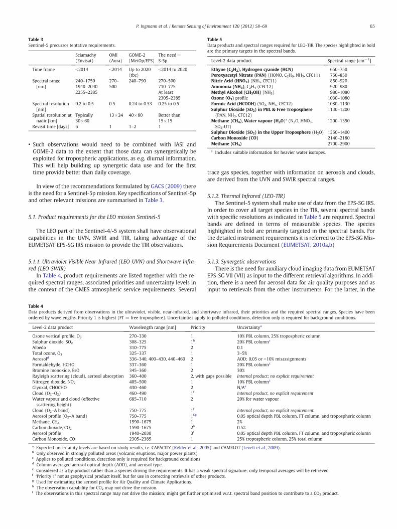
Table 3Sentinel-5 precursor tentative requirements.
Sciamachy(Envisat)
OMI(Aura)
GOME-2(MetOp/EPS)
The need=S-5p
Time frame b2014 b2014 Up to 2020(tbc)
b2014 to 2020
Spectral range[nm]
240–17501940–20402255–2385
270–500
240–790 270–500710–775At least2305–2385
Spectral resolution[nm]
0.2 to 0.5 0.5 0.24 to 0.53 0.25 to 0.5
Spatial resolution atnadir [km]
Typically30×60
13×24 40×80 Better than15×15
Revisit time [days] 6 1 1–2 1
Table 5Data products and spectral ranges required for LEO-TIR. The species highlighted in boldare the primary targets in the spectral bands.
Level-2 data product Spectral range [cm−1]
Ethyne (C2H2), Hydrogen cyanide (HCN) 650–750Peroxyacetyl Nitrate (PAN) (HONO, C2H6, NH3, CFC11) 750–850Nitric Acid (HNO3) (NH3, CFC11) 850–920Ammonia (NH3), C2H4 (CFC12) 920–980Methyl Alcohol (CH3OH) (NH3) 980–1080Ozone (O3) profile 1030–1080Formic Acid (HCOOH) (SO2, NH3, CFC12) 1080–1130Sulphur Dioxide (SO2) in PBL & Free Troposphere(PAN, NH3, CFC12)
1130–1200
Methane (CH4), Water vapour (H2O)a (N2O, HNO3,SO2-UT)
1200–1350
Sulphur Dioxide (SO2) in the Upper Troposphere (H2O) 1350–1400Carbon Monoxide (CO) 2140–2180Methane (CH4) 2700–2900
a Includes suitable information for heavier water isotopes.
65P. Ingmann et al. / Remote Sensing of Environment 120 (2012) 58–69
• Such observations would need to be combined with IASI andGOME-2 data to the extent that those data can synergetically beexploited for tropospheric applications, as e.g. diurnal information.This will help building up synergetic data use and for the firsttime provide better than daily coverage.
In view of the recommendations formulated by GACS (2009) thereis the need for a Sentinel-5p mission. Key specifications of Sentinel-5pand other relevant missions are summarised in Table 3.
5.1. Product requirements for the LEO mission Sentinel-5
The LEO part of the Sentinel-4/-5 system shall have observationalcapabilities in the UVN, SWIR and TIR, taking advantage of theEUMETSAT EPS-SG IRS mission to provide the TIR observations.
5.1.1. Ultraviolet Visible Near-Infrared (LEO-UVN) and Shortwave Infra-red (LEO-SWIR)
In Table 4, product requirements are listed together with the re-quired spectral ranges, associated priorities and uncertainty levels inthe context of the GMES atmospheric service requirements. Several
Table 4Data products derived from observations in the ultraviolet, visible, near-infrared, and shoordered by wavelengths. Priority 1 is highest (FT = free troposphere). Uncertainties apply
Level-2 data product Wavelength range [nm] Priority
Ozone vertical profile, O3 270–330 1Sulphur dioxide, SO2 308–325 1b
Albedo 310–775 2Total ozone, O3 325–337 1Aerosold 336–340, 400–430, 440–460 2Formaldehyde, HCHO 337–360 1Bromine monoxide, BrO 345–360 2Rayleigh scattering (cloud), aerosol absorption 360–400 2, withNitrogen dioxide, NO2 405–500 1Glyoxal, CHOCHO 430–460 2Cloud (O2–O2) 460–490 1f
Water vapour and cloud (effectivescattering height)
685–710 2
Cloud (O2–A band) 750–775 1f
Aerosol profile (O2–A band) 750–775 1f,g
Methane, CH4 1590–1675 1Carbon dioxide, CO2 1590–1675 2h
Aerosol profile 1940–2030 3i
Carbon Monoxide, CO 2305–2385 1
a Expected uncertainty levels are based on study results, i.e. CAPACITY (Kelder et al., 200b Only observed in strongly polluted areas (volcanic eruptions, major power plants)c Applies to polluted conditions, detection only is required for background conditionsd Column averaged aerosol optical depth (AOD), and aerosol type.e Considered as a by-product rather than a species driving the requirements. It has a wef ‘Priority 1’ not as geophysical product itself, but for use in correcting retrievals of otherg Used for estimating the aerosol profile for Air Quality and Climate Applications.h The observation capability for CO2 may not drive the mission.i The observations in this spectral range may not drive the mission; might get further op
trace gas species, together with information on aerosols and clouds,are derived from the UVN and SWIR spectral ranges.
5.1.2. Thermal Infrared (LEO-TIR)The Sentinel-5 system shall make use of data from the EPS-SG IRS.
In order to cover all target species in the TIR, several spectral bandswith specific resolutions as indicated in Table 5 are required. Spectralbands are defined in terms of measurable species. The specieshighlighted in bold are primarily targeted in the spectral bands. Forthe detailed instrument requirements it is referred to the EPS-SGMis-sion Requirements Document (EUMETSAT, 2010a,b)
5.1.3. Synergetic observationsThere is the need for auxiliary cloud imaging data from EUMETSAT
EPS-SG VII (VII) as input to the different retrieval algorithms. In addi-tion, there is a need for aerosol data for air quality purposes and asinput to retrievals from the other instruments. For the latter, in the
rtwave infrared, their priorities and the required spectral ranges. Species have beento polluted conditions, detection only is required for background conditions.
Uncertaintya
10% PBL column, 25% tropospheric column20% PBL columnc
0.13–5%AOD: 0.05 or b10% misassignments20% PBL columnc
30%gaps possible Internal product; no explicit requirement
10% PBL columnc
N/Ae
Internal product, no explicit requirement20% for water vapour
Internal product, no explicit requirement.0.05 optical depth PBL column, FT column, and tropospheric column2%0.5%0.05 optical depth PBL column, FT column, and tropospheric column25% tropospheric column, 25% total column
5) and CAMELOT (Levelt et al., 2009).
ak spectral signature; only temporal averages will be retrieved.products.
timised w.r.t. spectral band position to contribute to a CO2 product.

Table 6GEO-UVN data products, required spectral ranges, and priorities.
Level-2 dataproduct
Wavelengthrange [nm]
Priority Uncertaintya
Troposphericozone, O3
305–330 1 10% PBL column, 25%tropospheric column
Sulphur dioxide,SO2
308–325 1b 20% PBL columnc
Albedo 310–775 2 0.1Total ozone, O3 325–337 1 3–5%Aerosold 336–340,
400–430,440–460
2 AOD: 0.05 or b10%misassignments
Formaldehyde,HCHO
337–360 1 20% PBL columnc
Rayleigh scattering(cloud), aerosolabsorption
360–400 2, withgapspossible
Internal product, no explicitrequirement
Nitrogen dioxide,NO2
405–500 1 10% PBL columnc
Glyoxal, CHOCHO 430–460 2 N/Ae
Cloud (O2–O2) 460–490 1f Internal product, no explicitrequirement
Cloud (O2–A) 750–775 1 Internal product, no explicitrequirement
Aerosol profile(O2–A band)
750–775 1f,g 0.05 optical depth PBL column,FT column, tropospheric column
a Expected uncertainty levels are based on study results, i.e. CAPACITY (Kelder et al.,2005) and CAMELOT (Levelt et al., 2009).
b Only observed under moderate to high pollution conditions.c Applies to polluted conditions, detection only is required for background condi-
tions.d Column averaged AOD, and aerosol type.e Considered as a by-product rather than a species driving the requirements. It has a
weak spectral signature, only temporal averages will be retrieved.f ‘Priority 1’ not as geophysical product itself, but for use in correcting retrievals of
other products.g Used for estimating the aerosol profile for Air Quality and Climate Applications.
Table 7GEO-TIR target species and spectral bands.
Species Spectral range [cm−1]
H2O, O3, CO2, Surface, Clouds, Aerosols,HNO3, NH3, CH3OH, HCOOH
700–1210
H2O, CO, N2O 1600–2175
66 P. Ingmann et al. / Remote Sensing of Environment 120 (2012) 58–69
case of Sentinel-5 the data from EUMETSAT EPS-SG 3MI (3MI) are as-sumed to be available, although the implementation of this instru-ment has not yet been confirmed.
Synergetic retrievals are envisaged from various bands:
• ozone from a combination of UV and TIR bands,• CO from a combination of SWIR and TIR bands,• CH4 from a combination of SWIR and TIR bands,• cloud information from the NIR (i.e., O2–A) band used in UV–vis andSWIR retrievals,
• cloud information from VII used in UV–vis, SWIR and TIR retrievals,• refined cloud characterisation from the combination of all instru-ments, and
• aerosol information from UV–vis, Near-IR and 3MI, also used intrace gas retrievals in UV–vis.
The synergetic retrievals require observations of a consistentscene resulting in requirements for co-registration in time and space.
5.2. Sentinel-5 precursor
The payload of Sentinel-5 Precursor shall satisfy the requirementsprovided above for the Sentinel-5 UVNS spectrometers with the fol-lowing exceptions:
• the time frame of the precursor mission is 2014–2020;• the precursor shall include the UVN and the SWIR-3 spectral bands.Considering the transitional nature of the precursor and the avail-ability of TIR from the IASI instrument currently flying on theEUMETSAT EPS/Metop satellite, it is neither considered necessarynor efficient to implement another TIR sounder in parallel to EPS/Metop;
• as the EUMETSAT EPS-SG satellite is not scheduled to fly in thistime-frame, no auxiliary data from the VII nor from the 3MI willbe available.
The Sentinel-5 Precursor cannot benefit from the synergy withvarious instruments planned for EPS-SG. Therefore, it shall be flownon a sun-synchronous low Earth orbit with an equator crossingmean local solar time of 13:30 h. The early afternoon orbit is pre-ferred for the following reasons:
• an afternoon orbit will allow a start into observation of diurnal var-iability in synergy with Metop's GOME-2 and IASI data; this wouldhardly be possible in the reverse case of a morning orbit and syner-gy with NPP/JPSS, due to the specification values of the relevantNPP/JPSS instruments which are not designed for chemical mea-surements in the troposphere;
• early afternoon provides better observation conditions in solarchannels than late afternoon, due to more favourable solar zenithangles;
• in a 13:30 h orbit, advantage can be taken by synergetic exploita-tion of simultaneous measurements of stratospheric ozone profilesby OMPS on the NPP/JPSS platforms and of imager data of (Visi-ble/Infrared Imager Radiometer Suite) VIIRS on JPSS. The timedelay between observations of a scene by NPP/JPSS and Sentinel-5precursor shall be in the order of minutes;
• an early afternoon orbit will be most suitable for continuation of thedata record of short-lived tropospheric species from OMI on EOS-Aura, which has been started in 2004, with a 13:45 equator crossingtime.
5.3. Product requirements for the GEO mission Sentinel-4
5.3.1. Ultraviolet Visible Near-infrared (GEO-UVN)In Table 6, product requirements are listed together with the re-
quired spectral ranges, associated priorities and uncertainty levels inthe context of the GMES atmospheric service requirements. Several
trace gas species, together with information on aerosols and clouds,are derived from the UVN spectral ranges.
5.3.2. Thermal Infrared (GEO-TIR)The target species, together with the required spectral bands, are
listed in Table 7.The Sentinel-4 system shall make use of data from the EUMETSAT
MTG-S IRS. It is understood that the sounder is optimised for opera-tional meteorology use. For the latter reason it is expected that notall species can be derived, e.g. NH3, CH3OH. For the detailed instru-ment requirements it is referred to the MTG-Mission RequirementsDocument (EUMETSAT, 2007) and the MTG-End User RequirementsDocument (EUMETSAT, 2010b).
5.3.3. Synergetic observationsThere is the need for auxiliary imaging data from the EUMETSAT
MTG-I FCI (FCI) as input for the different retrieval algorithms.Synergetic retrievals are envisaged from various bands:
• ozone from a combination of UV and TIR bands,• cloud information from the NIR (i.e., O2–A) band used in UV–visretrievals,
• cloud information from FCI used in the UV–vis and TIR retrievals,

Table 9Sentinel-5-UVNS observation requirements.
Band ID Spectral Spectral Spectral Spatial sampling at
67P. Ingmann et al. / Remote Sensing of Environment 120 (2012) 58–69
• refined cloud characterisation from the combination of allinstruments,
• aerosol retrievals from UV–vis, Near-IR and the FCI, also used intrace gas retrievals in UV–vis.
The lightning imager (LI) instrument is a EUMETSAT core payloadon the MTG-I satellite. Data from the LI on MTG-I will be used for es-timating the NO2 production due to lightning and the associated con-tribution to the NO2 column observed in the visible.
The synergetic retrievals require observations of a consistentscene resulting in requirements for co-registration in time and space.
6. Status of mission implementation
6.1. The Sentinel-4 mission
6.1.1. The Sentinel-4 systemThe Sentinel-4/UVN instruments are procured within the ESA
GMES programme. They will be provided to the MTG programmefor embarkation on the MTG-Sounder (MTG-S) satellite as a CustomerFurnished Item (CFI), fully verified and qualified together with itsnecessary ground support equipment, test models and system deliv-erable inputs.
The Sentinel-4 observation capability is defined as the Sentinel-4-UVN instrument(s) and utilisation of a subset of data from the FCI in-struments on MTG-I and the IRS instruments on MTG-S. The IRS andthe FCI instruments are core EUMETSAT payloads designed primarilyto provide meteorological information for the Numerical WeatherPrediction (NWP) and Nowcasting communities.
The Sentinel-4 project has started with the detailed design phasein the first quarter of 2011. The present target dates for the deliveryof the instruments to the MTG programme are 2016 for the first flightmodel and 2018 for the second flight model.
Planned launch date of the first MTG-S satellite is 2018. The sec-ond satellite is expected to be launched in 2027.
6.1.2. The Sentinel-4 UVN instrumentThe Sentinel-4 UVN instrument is a high resolution spectrometer
covering the
• ultraviolet (305–400 nm),• visible (400–500 nm) and• near-infrared (750–775 nm) bands.
The spatial sampling is 8 km at 45° North (0° longitude) with aspectral resolution between 0.12 nm and 0.5 nm depending on thespectral band. The Sentinel-4-UVN instrument is a push-broom imag-ing spectrometer that scans Europe in the East–west direction with arepeat cycle of 60 min and with field-of-regard of ~6.8° in the East–west direction and ~3.6° in the North–south direction. Table 8 givesan overview of the characteristics of the Sentinel-4-UVN UV to NIRbands (cf Table 6).
The tentative instrument interface data are as follows:
• Mass including electronics ~150 kg• Power consumption ~180 W (average)• Data Rate during acquisition ≤30 Mbps• Mission reliability ≥0.75 at 8.5 years
Table 8Sentinel-4-UVN observation requirements.
BandID
Bands[nm]
Spectralresolution [nm]
Spectralsampling ratio
Spatial sampling at 45N,0E [km]
GEO-UV 305–400 0.5 3 8GEO-VIS 400–500 0.5 3 8GEO-NIR 750–775 0.12 3 8
6.1.3. The EUMETSAT IRS instrumentThe MTG-S IRS instrument is a high resolution spectrometer cov-
ering two infrared bands:
• 700–1210 cm−1
• 1650–2175 cm−1
The spatial sampling is 4 km at sub-satellite point and from therein constant angles over the entire Earth disc. Spectral resolution is0.754 cm−1. The IRS instrument is a Fourier Transform spectrometerused in step and stare modes. Each dwell lasts 10 s in which simulta-neously all pixels are measured within a 640 km×640 km area. TheEarth disc is separated in 4 zones, each of them being covered in15 min. In the standard measurement scenario, the northern zone—which includes Europe—is measured twice hourly. The scanning pat-tern over the whole Earth is repeated 4 times per day.
6.2. The Sentinel-5p mission
Sentinel-5p will be implemented within ESA's GMES programmewith a major Dutch national contribution. The basic design is basedon the TROPospheric Ozone Monitoring Instrument (TROPOMI), asuccessor of OMI on NASA's EOS-Aura platform. With respect toOMI, TROPOMI will provide not only near-infrared but also short-wave infrared coverage. In addition, the higher spatial resolutionwill increase the proportion of cloud-free samples. The TROPOMI(=national) project is approaching the end of the detailed designphase and was closed with an instrument preliminary design review(IPDR) in spring 2011. The system level feasibility study was kicked-off in summer 2010 and shall be followed by the detailed designphase and start of the implementation phase presently scheduledfor the second half of 2011.The tentative launch date is at the end of2014.
More details about the Sentinel-5 precursor mission can be foundelsewhere in this volume (Veefkind et al., 2011, this RSE issue).
6.3. The Sentinel-5 mission
The Sentinel-5 UVNS instrument is a high resolution spectrometercovering the
• ultraviolet (305–370 nm),• visible (370–500 nm),• visible/near-infrared (685–710, 750–775 nm)• and short-wave infrared bands (1590–1675, 1940–2030,2305–2385).
The spatial sampling shall be 15 km (T) and 5 km (G) for most ofthe bands and the spectral resolution between 0.4 nm and 1.0 nm(all T values) depending on the spectral band.
Table 9 gives an overview of the characteristics of the Sentinel-5-UVNS UV to SWIR bands (cf Table 4).
range [nm] resolution [nm] sampling ratio nadir [km]
LEO-UV-1 270–300 1.0 3 50 km (T)/15 km (G)LEO-UV-2 300–370 0.5 3 15 km (T)/5 km (G)LEO-VIS 370–500 0.5 3 15 km (T)/5 km (G)LEO-NIR-1 685–710 0.4 (T)/0.2 (G) 3 15 km (T)/5 km (G)LEO-NIR-2 750–775 0.4 (T)/0.06 (G) 3 15 km (T)/5 km (G)LEO-SWIR-1 1590–1675 0.25 3 15 km (T)/5 km (G)LEO-SWIR-2 1940–2030 0.25 3 15 km (T)/5 km (G)LEO-SWIR-3 2305–2385 0.25 3 15 km (T)/5 km (G)

Table 10Summary of the implementation scenarios for Sentinels-4, -5p and -5 addressing GMESAtmospheric Service Requirements.
UV-VIS- NIR, SWIR TIR
Orbit LEO GEO LEO GEO
Temporal sampling Daily Hourly Daily Hourly
Instrument UVNS TROPOMI UVN IRS IRS
(Host) satellite EPS-SG Free flyer MTG-S EPS-SG MTG-S
Synergy VII, 3MI VIIRS+OMPS+CRIS/NPP, /JPSS
FCI, LI/MTG-I VII FCI /MTG-I
Sentinel-4 ×× ×Sentinel-5p ×Sentinel-5 × ×
68 P. Ingmann et al. / Remote Sensing of Environment 120 (2012) 58–69
The (very) tentative instrument interface data are as follows:
• Mass including electronics ~200 kg (TBC)• Power consumption ~200 W (average, TBC)• Data Rate during acquisition ≤30 Mbps (day-time, TBC)
Sentinel-5 will also be implemented within ESA's GMES pro-gramme. Like Sentinel-4, the instruments are planned to be providedto a future EPS-SG programme for embarkation on the EPS-SG satel-lites as CFIs. Preparatory activities have been approved. Feasibilitystudies for Sentinel-5 have started in 2011. Final approval and fund-ing are expected in the 2011/12 time-frame by ESA and EUMETSAT.The tentative launch date is 2020.
7. Conclusions
The requirements heritage leading to the implementation of theatmospheric composition element of GMES has been outlined. Thenature and origin of the requirements and also the programmaticbackground for implementing the GMES Atmospheric Services relat-ed missions have been explained.
The implementation of the atmospheric composition element ofGMES Space Component, i.e. Sentinel-4, Sentinel-5p and Sentinel-5,is well underway. However, due to the nature of the programmeand related to the programmatic frame, the missions are in variousstages of development. Sentinel-4 is in a rather advanced status inline with the maturity of the MTG programme. The situation is rathersimilar for Sentinel-5p due to the preparatory work performed at na-tional level in the Netherlands. For Sentinel-5, the situation is muchmore open as the mission complement is still in the payload selectionphase. Table 10 summarises the implementation scenarios forSentinels-4, -5p and-5.
The successive implementation of the various elements isexpected in the period between 2014 and 2020 with Sentinel-5pfirst (2014), followed by Sentinel-4 (as of 2018) and Sentinel 5 (asof 2020).
Acknowledgement
We would like to thank the teams involved in the CAPACITY andCAMELOT studies both lead by the Royal Netherlands MeteorologicalInstitute (KNMI) and their partner institutes who were instrumentalin elaborating the inputs to frame the Sentinel-4, -5 and 5p missions.In addition, special thanks to Heinrich Bovensmann (University ofBremen), Richard Engelen (ECMWF), Thilo Erbertseder (DLR), Pieter-nel Levelt (KNMI and Technical University Eindhoven), AdrianSimmons (ECMWF), Vincent-Henri Peuch (Météo France) now atECMWF and Thierry Phulpin (CNES) for their valuable comments.
References
Barrie, L., & Langen, J. (2004). An Integrated Global Atmospheric Chemistry ObservationTheme for the IGOS Partnership (IGACO), ESA SP-1282, WMO GAW No. 159 e.g.from ftp://ftp.wmo.int/Documents/PublicWeb/arep/gaw/gaw159.pdf
Beer, R., Glavich, T. A., & Rider, D. M. (2001). Tropospheric emission spectrometer forthe Earth Observing System's Aura satellite. Applied Optics, 40, 2356–2367.
Blumstein, D., Chalon, G., Carlier, T., Buil, C., Hébert, P., Maciaszek, T., et al. (2004). IASIinstrument: Technical overview and measured performances. Proceedings of SPIE,5543, 196–207.
Bovensmann, H., Burrows, J. P., Buchwitz, M., Frerick, J., Noël, S., Rozanov, V. V., et al.(1999). SCIAMACHY: Mission objectives and measurement modes. Journal of theAtmospheric Sciences, 56, 127–150.
Bréon, F. M., Peylin, P., Bousquet, P., Camy-Peyret, C., Ciais, P., Clerbaux, C., et al. (2003).The potential of remote sensing to contribute to the quantification of anthropogen-ic emissions in the frame of the Kyoto Protocol. Final Report and Technical Notes ofESA Study Contract no. 15427/01/NL/MM.
Burrows, J. P., Weber, M., Buchwitz, M., Rozanov, V., Ladstätter-Weissenmeyer, A., Richter,A., et al. (1999). The Global OzoneMonitoring Experiment (GOME)—Mission conceptand first scientific results. Journal of the Atmospheric Sciences, 56, 151–175.
Clerbaux, C., Boynard, A., Clarisse, L., George, M., Hadji-Lazaro, J., Herbin, H., et al. (2009).Monitoring of atmospheric composition using the thermal infrared IASI/MetOpsounder. Atmospheric Chemistry and Physics, 9, 6041–6054.
Crisp, D., Atlas, R. M., Breon, F. M., Brown, L. R., Burrows, J. P., Ciais, P., et al. (2004).The Orbiting Carbon Observatory (OCO) mission. Advances in Space Research, 34,700–709.
Drummond, J. R., & Mand, G. S. (1996). The Measurements of Pollution in the Tropo-sphere (MOPITT) Instrument: Overall performance and calibration requirements.Journal of Atmospheric and Oceanic Technology, 13, 314–320.
EUMETSAT (2007). MTG Mission Requirements Document, v2C. http://www.eumetsat.int/groups/pps/documents/document/pdf_mtg_mrd.pdf
EUMETSAT (2010). Post-EPS Mission Requirements Document, v3C. http://www.eumetsat.int/groups/pps/documents/document/pdf_peps_mrd.pdf
EUMETSAT (2010). MTG End User Requirements Document, v3C. http://www.eumetsat.int/groups/ops/documents/document/pdf_mtg_eurd.pdf
GCOS Implementation Plan for the Global Observing System for Climate in Support ofthe UNFCCC (2010). GCOS-138, (GOOS-184, GTOS-76, WMO-TD/No. 1523). http://www.wmo.int/pages/prog/gcos/Publications/gcos-138.pdf
GMES Atmosphere Core Service (GACS) (2009). GMES Atmospheric Service Implemen-tation Group Space Observation Infrastructure for the GMES Atmosphere Core Ser-vice—Summary for the Implementation Group: Conclusions and Recommendations.http://www.gmes.info/pages-principales/library/implementation-groups/gmes-atmosphere-core-service/?no_cache=1&download=GMES_Atmosphere_Core_Service_Implementation_Group_Final_Report.pdf
GMES-GATO Strategy Report (2004). Global Monitoring for Environment and Security-Global Atmospheric Observations. http://www.nilu.no/gmes-gato/download
Golding, B. W., Senesi, S., Browning, K., Bizzarri, B., Benesch, W., Rosenfeld, D., et al.(2003). EUMETSAT position paper on Observation Requirements for Now Castingand Very Short Range Forecasting in 2015–2025. http://www.eumetsat.int/groups/pps/documents/document/pdf_mtg_aeg_nwc_positionpaper.pdf
Heath, D. F., Krueger, A. J., Roeder, H. A., & Henderson, B. D. (1975). The Solar Backscat-ter Ultraviolet and Total Ozone Mapping Spectrometer (SBUV/TOMS) for NimbusG. Optical Engineering, 14, 323–331.
Heath, D. F., Mateer, C. L., & Krueger, A. J. (1973). The Nimbus-4 Backscatter Ultraviolet(BUV) atmospheric ozone experiment—Two years operation. Pure and Applied Geo-physics, 106–108, 1238–1253.
Hollingsworth, A., Engelen, R. J., Textor, C., Benedetti, A., Boucher, O., Chevallier, F., et al.(2008). Toward a monitoring and forecasting system for atmospheric composition.The GEMS Project. Bulletin of the American Meteorological Society, 89, 1147–1164,doi:10.1175/2008BAMS2355.1.
Hungershoefer, K., Breon, F. -M., Peylin, P., Chevallier, F., Rayner, P., Klonecki, A., et al.(2010). Evaluation of various observing systems for the global monitoring of CO2
surface fluxes. Atmospheric Chemistry and Physics, 10, 10503–10520, doi:10.5194/acp-10-10503-2010, 2010.
Kelder, H., van Weele, M., Goede, A., Kerridge, B., Reburn, J., Bovensmann, H., et al.(2005). CAPACITY (Operational Atmospheric Chemistry Monitoring Missions).Final Report and Technical Notes of ESA Study, Contract number 17237/03/NL/GSalso http://www.knmi.nl/capacity/
Kelder, H., et al. (2006). Requirements for operational atmospheric chemistry monitoring inthe post-EPS timeframe beyond 2020, Position paper on post-EPS atmospheric chemistrydata user requirements. http://www.eumetsat.int/groups/pps/documents/document/pdf_peps_pp_atmos_chem.pdf
Kobayashi, H., Shimota, A., Kondo, K., Okumura, E., Kameda, Y., Shimoda, H., et al.(1999). Development and evaluation of the interferometric monitor for green-house gases: a high-throughput Fourier-transform infrared radiometer for nadirEarth observation. Applied Optics, 38, 6801–6807.
Kuze, A., Suto, H., Nakajima, M., & Hamazaki, T. (2009). Thermal and near infrared sensorfor carbon observation Fourier-transform spectrometer on the Greenhouse GasesObserving Satellite for greenhouse gases monitoring. Applied Optics, 48, 6716–6733.
Lelieveld, J. (2003). Geo-stationary Satellite Observations for Monitoring AtmosphericComposition and Chemistry Applications, EUMETSAT study for Meteosat Third Gener-ation 2015–2025. http://www.eumetsat.int/groups/pps/documents/document/pdf_mtg_rep01.pdf
Levelt, P. F., van den Oord, G. H. J., Dobber, M. R., Mälkki, A., Visser, H., de Vries, J., et al.(2006). The ozone monitoring instrument. IEEE Transactions on Geoscience andRemote Sensing, 44(5), 1093–1101, doi:10.1109/TGRS.2006.872333.

69P. Ingmann et al. / Remote Sensing of Environment 120 (2012) 58–69
Levelt, P. F., Veefkind, J. P., Kerridge, B. J., Siddans, R., de Leeuw, G., Remedios, J., et al.(2009). CAMELOT (Observation Techniques and Mission Concepts for AtmosphericChemistry). Final Report of the ESA study, Contract nr. 20533/06/NL/HE ExecutiveSummary:. http://esamultimedia.esa.int/docs/gsp/completed/C21533ExS.Pdf
McCormick, M. P., Zawodny, J. M., Veiga, R. E., Larsen, J. C., & Wang, P. -H. (1989). Anoverview of SAGE I and II ozone measurements. Planetary and Space Science,37(12), 1567–1586.
PROMOTE (2009). Protocol Monitoring for the GMES Service Element, Atmosphere Service,Final Report. http://www.gse-promote.org/docs/FinalReport_WebVersion.pdf
Reuter, M., Bovensmann, H., Buchwitz, M., Burrows, J. P., Connor, B. J., Deutscher, N. M.,et al. (2011). Retrieval of atmospheric CO2 with enhanced accuracy and precisionfrom SCIAMACHY: Validation with FTS measurements and comparison with modelresults. Journal of Geophysical Research, 116, D04301, doi:10.1029/2010JD015047.
Salomonson, V. V., Barnes, W. L., Maymon, P. W., Montgomery, H. E., & Ostrow, H.(1989). MODIS: advanced facility instrument for studies of the Earth as a system.IEEE Transactions on Geoscience and Remote Sensing, 27, 145–153.
Singer, S. F., & Wentworth, R. C. (1957). A method for the determination of the verticalozone distribution from a satellite. Journal of Geophysical Research, 62, 299–308.
UNECE (1979). United Nations Economic Commission for Europe, Convention on Long-Range Transboundary Air Pollution. http://www.unece.org/env/lrtap/
UNEP (2000). Ozone Secretariat, The Montreal Protocol on Substances that Deplete theOzone Layer as either adjusted and/or amended in London 1990, Copenhagen 1992,Vienna 1995, Montreal 1997, Beijing 1999, 2000. 92-807-1888-6 also available at.http://www.unep.org/OZONE/pdfs/Montreal-Protocol2000.pdf
UNEP (2006). The Vienna Convention for the Protection of the Ozone Layer, UNEPOzone Secretariat. http://ozone.unep.org/Publications/VC_Handbook/Section_1_The_Vienna_Convention/index.shtml
UNFCCC (1992). United Nations Framework Convention on Climate Change. http://unfccc.int/resource/docs/convkp/conveng.pdf
United Nations (1998). The Kyoto Protocol to the United Nations Framework Conventionon Climate Change. http://unfccc.int/resource/docs/convkp/kpeng.pdf
List of acronyms
3MI: Multi-Viewing Multi-Channel Multi-Polarisation ImagerAEM: Atmospheric Explorer MissionAOD: Aerosol optical depthAQ: Air QualityB: breakthrough (requirement)BUV: backscatter ultravioletCFI: Customer Furnished ItemCLRTAP: Convention on Long-Range Transboundary Air PollutionCOPD: Chronic Obstructive Pulmonary DiseaseCrIS: Cross-track Infrared SounderECV: Essential Climate VariableEPS: European Polar SystemERBS: Earth Radiation Budget SatelliteESA: European Space AgencyEU: European UnionEUMETSAT: European Organisation for the Exploitation of Meteorological SatellitesEVOSS: European Volcano Observatory Space Services project
FCI: Flexible Combined ImagerFP: Framework ProgrammeFT: Free TroposphereG: Goal (requirement)GAS: GMES Atmospheric ServiceGCOS: Global Climate Observing SystemGEMS: Global and regional Earth-system Monitoring using Satellite and in-situ dataGEO: GEosynchronous OrbitGMES: Global Monitoring for Environment and SecurityGOME: Global Ozone Monitoring ExperimentGOSAT: Greenhouse Gas Observing SatelliteIASI: Infrared Atmospheric Sounding InterferometerIG: Implementation GroupIMG: Interferometric Monitor for Greenhouse GasesIPCC: Intergovernmental Panel on Climate ChangeIPDR: Instrument Preliminary Design ReviewIR: InfraredIRS: IR sounderJPSS: Joint Polar Satellite SystemLEO: Low Earth OrbitLI: Lightning ImagerMACC: Monitoring Atmospheric Composition and ClimateMODIS: Moderate Resolution Imaging SpectroradiometerMOPITT: Measurements of Pollution in the TroposphereMRD: Mission Requirements DocumentMTG: Meteosat Third GenerationMTG-S: MTG-SounderNIR: Near IRNPP: NPOESS Preparatory ProjectNWP: Numerical Weather PredictionOCO: Orbiting Carbon ObservatoryOMI: Ozone Monitoring InstrumentOMPS: Ozone Mapping and Profiling SuitePBL: Planetary Boundary LayerPM: Particulate MatterS3: GMES Sentinel-3SAGE: Stratospheric Aerosol and Gas ExperimentSBUV: Solar BUVSciamachy: SCanning Imaging Absorption spectroMeter for Atmospheric ChartographYSG: Second GenerationSNR: Signal-to-Noise-RatioSSD: Spatial Sampling DistanceSWIR: Short-Wave IRT: Threshold (requirement)TBC: To Be ConfirmedTES: Thermal Emission SpectrometerTIR: Thermal IRTOMS: Total Ozone Mapping SpectrometerTROPOMI: TROPospheric Ozone Monitoring InstrumentUTLS: Upper Troposphere/Lower StratosphereUVN: Ultraviolet–visible–Near IRVII: VIS/IR ImagerVIS: VisibleVOC: Volatile Organic Compounds