report card january to march 2015 - home - roads … · western sydney infrastructure plan report...
TRANSCRIPT

Western Sydney Infrastructure PlanReport Card January to March 2015
Construction earthwork at Bringelly Road upgrade Stage 1 at Cowpasture Road, Leppington

Western Sydney Infrastructure Plan | Report Card | January to March 2015
Message from the Ministers 1
Western Sydney Infrastructure Plan overview 2
Progress so far 4
Environment 6
Work, Health and Safety 6
Employment 7
Consultation 8
Roads in construction 9
Bringelly Road upgrade Stage 1 9
Werrington Arterial Road 12
Roads in final design 15
Bringelly Road upgrade Stage 2 15
The Northern Road upgrade Stage 1 17
The Northern Road upgrade Stage 2 19
Roads in planning 21
The Northern Road upgrade Stage 3 21
The Northern Road upgrade Stage 4 23
The M12 Motorway 25
Bringelly Road and The Northern Road interchange 27
Glenbrook intersection upgrade 29
Local Roads Package 30
Contents

Welcome to the first comprehensive report card for the Australian and NSW governments’ $3.6 billion, 10 year Western Sydney Infrastructure Plan – a program of major road infrastructure.
The Australian and NSW governments are delivering a package of world class road projects to support an integrated transport solution for the western Sydney region which will capitalise on the economic gains of building an airport for western Sydney.
The Western Sydney Infrastructure Plan will provide improved road transport capacity ahead of future traffic demand and act as a catalyst for significant employment and residential development in western Sydney and the Broader Western Sydney Employment Area (BWSEA). The Australian and NSW governments are improving the road network before a western Sydney airport is operational creating thousands of direct and indirect jobs.
Western Sydney is expected to undergo unprecedented growth with about one million additional people living in the region by 2031. It is vital to ensure the road infrastructure supports transport connections, moves freight, eases congestion, provides more reliable travel times and makes roads safer.
The plan upgrades major corridors including Bringelly Road (construction underway) and The Northern Road, and upgrades existing roads between the M4 Motorway and the Great Western Highway to form the Werrington Arterial Road (construction underway). It will also deliver a new $1.2 billion M12 Motorway providing direct airport access.
These new and upgraded roads will be safer and will generally feature four lanes with capacity for six lanes in the future, central medians to separate traffic, wide shoulders and improved street lighting, particularly at intersections. They will also improve bus priority and will provide off road paths for cyclists and pedestrians.
As part of the plan, the Australian Government is also investing $200 million in a Local Roads Package, enabling western Sydney councils to deliver improved road connections to support the Western Sydney Infrastructure Plan objectives.
Message from the Ministers
The Hon Jamie Briggs MPAssistant Minister for Infrastructure and Regional Development
The Hon Duncan John Gay MLCNSW Minister for Roads, Maritime and Freight
Western Sydney Infrastructure Plan | Report Card | January to March 2015 1

2 Western Sydney Infrastructure Plan | Report Card | January to March 2015
NORTH WESTGROWTH AREA
Port Botany
WestConnexMotorway
NorthConnexMotorway
Camden
NarellanCampbelltown
Heathcote
SutherlandMiranda
Cronulla
East Hills
Bankstown
Liverpool
Cabramatta
Fairfield
Prairiewood
Parramatta
Blacktown
Castle Hill
Mt DruittSt Marys
Penrith
GlenmorePark
Glenbrook
Luddenham
BringellyLeppington
OranPark
Hornsby
EppingMacquarie
Park
Strathfield
Homebush
EasternCreek
Burwood
Hurstville
Kogarah
Maroubra
Bondi Junction
SydneyCBD
NorthSydney
St LeonardsChatswood
Manly
Brookvale
Dee Why
TerryHills
Chullora
Minto
The Northern Road upgrade $1.6 billion
Diversion of The Northern Road
M12 Motorway $1.2 billion
Elizabeth Drive
Bringelly Road
Narellan Road
Cam
den
Valle
y W
ay
The N
orthern R
oad
The
No
rthe
rn R
oad
Werrington Arterial Road $70 million
Ross Street / Great Western Highway intersection upgrade $5 million
Bringelly Road upgrade $509 million
M31
M5
M7
M7M2
M4
M1
Proposed western Sydney airport at Badgerys Creek
SOUTH WESTGROWTH
AREA
The Northern Road and Erskine Park Road intersection upgrade studies $1.1 million
Wetherill Street upgrade $5.7 million
Eagle Vale Drive upgrade $17.5 million
Cumberland Highway intersection upgrades $5.8 million
Argyle Street/Camden Valley Way corridor upgrade and studies $2.3 million
North West Rail Link – under construction
South WestRail LinkExtension
Local Roads Package $200 million (Australian Government funded)
Local Roads Package
Major road projects
Route to be determined
Future transport links
Rail
LEGEND
BROADERWESTERNSYDNEY
EMPLOYMENTAREA
Above: Western Sydney Infrastructure Plan overview map

Castle Hill
Epping
Blacktown
Mt Druitt
Chullora
Parramatta
MacquariePark
Strathfield
HurstvilleLeppington
OranPark
Burwood
LiverpoolBankstown
St Marys
Penrith
Sutherland Cronulla
Campbelltown
Miranda
Narellan
Camden
Heathcote
East HillsPrestons
M4
M4
M7
M5
M2
M31
Elizabeth Drive
Great Western Highway
King Georges R
oad
Bringelly Road
Narellan Road
Camde
n Va
lley
Way
The
Nor
the
rn R
oad
M7
The
Nor
ther
n R
oa
d
The North
ern R
oad
Stage 1
Stage 2
Stage 3
Stage 4
The Bringelly Road and The Northern Road Interchange
The new and upgraded Western Sydney Infrastructure Plan roads are being fast-tracked for delivery since the Australian and NSW governments announced this vital western Sydney infrastructure package on 16 April 2014.
The overview map on page two shows the planned 57km of Western Sydney Infrastructure Plan roads in context with the rest of Sydney, the proposed western Sydney airport, future transport corridors, employment centres and existing transport links. These high quality road improvements aim to deliver significant, ongoing safety and congestion-relieving benefits for customers.
The new 2km Werrington Arterial Road – an upgrade of existing roads to form a high quality link between the Great Western Highway and M4 Motorway – is being built, along with Stage 1 of the Bringelly Road upgrade.
The 10km Bringelly Road upgrade is being delivered in two stages between Camden Valley Way, Leppington and The Northern Road, Bringelly. It includes all Western Sydney Infrastructure Plan features and benefits. It will generally provide four lanes with a six lane divided road from east of Eastwood Road to east of Cowpasture Road (south), through the future Leppington Town Centre.
The Bringelly Road upgrade stages are:
• Stage 1: 5.7km from Camden Valley Way, Leppington to King Street, Rossmore
• Stage 2: 4.3km from King Street, Rossmore to The Northern Road, Bringelly.
The new M12 Motorway, a high grade, east-west link to the proposed airport, is in early planning.
The Northern Road upgrade, about 30km in length, from the M4 Motorway at Orchard Hills to the Old Northern Road, Narellan, is being delivered in four stages and integrates all key Western Sydney Infrastructure Plan features and benefits. It will cater for future traffic from planned residential and commercial developments in time for the proposed airport opening in the mid 2020s.
The Northern Road upgrade stages are:
• Stage 1: 3.3km between Old Northern Road, Narellan and Peter Brock Drive, Oran Park
• Stage 2: 11km between Peter Brock Drive, Oran Park and Mersey Road, Bringelly
• Stage 3: 7km between Elizabeth Drive, Luddenham and the M4 Motorway, Orchard Hills
• Stage 4: 9km between Mersey Road, Bringelly and Elizabeth Drive, Luddenham.
A grade separated Bringelly Road and The Northern Road Interchange will be delivered as part of the The Northern Road and Bringelly Road upgrades. Above: The Northern Road upgrade stages
Western Sydney Infrastructure Plan overview
Western Sydney Infrastructure Plan | Report Card | January to March 2015 3

The Australian and NSW governments have made significant progress to deliver the Western Sydney Infrastructure Plan in the past three months.
Roads and Maritime have commenced construction on 7.7km of the 57km of Western Sydney Infrastructure Plan roads between January and March 2015 on the
Werrington Arterial Road and Bringelly Road upgrade Stage 1 sites.
About 75 intersections will be built or upgraded for the Western Sydney Infrastructure Plan projects in the next 10 years. 14 of these intersections are now under construction.
7.7kmRoads underconstruction
UNDERCONSTRUCTION IN PLANNING OR DESIGN
0 11 23 34 46 57
to be built
75Intersections
under construction
14Intersections
Progress so far
Ten kilometres of the 63km of shared pedestrian and cyclist paths were being built between January and March 2015.
10kmShared pedestrian and cyclist paths under construction
UNDERCONSTRUCTION IN PLANNING OR DESIGN
0 6 13 19 25 32 38 44 50 57 63
Western Sydney Infrastructure Plan | Report Card | January to March 20154

5Western Sydney Infrastructure Plan | Report Card | January to March 2015
Of the $3.6 billion Western Sydney Infrastructure Plan the Australian Government will fund $2.9 billion while the NSW Government will provide around $700 million.
Peak expenditure for the 10-year program is forecast to be between $700 million to $800 million in the 2018–19 financial year when the majority of projects are under construction.
The Western Sydney Infrastructure Plan is forecast to spend $74 million this financial year.
Four key milestones were completed on time by the end of this quarter. These included:
• awarding the construction contract for Werrington Arterial Road
• construction starting on Bringelly Road upgrade Stage 1
• construction starting on Werrington Arterial Road
• completion of detailed design for The Northern Road upgrade Stage 1.
2014/15 2015/16 2016/17 2017/18 2018/19 2019/20 2020/21 2021/22 2022/23
$ m
illio
nA
nn
ual
Sp
end
/bu
dg
et
Financial year
0
400
800
$3.6bn
Western Sydney Infrastructure Plan 10 year expenditure forecast
Jun 14 Sep 14 Dec 14 Mar 152014/15
$ m
illio
n
June 150
20
40
60
80
Actual Forecast
0
1
2
3
4
Mile
sto
nes
co
mp
lete
d
Jun 14 Sep 14 Dec 14 Mar 15 June 15
Completed milestones
Forecast milestones
2014/15
Quarter 3 Expenditure and milestone performance
Progress so far

6 Western Sydney Infrastructure Plan | Report Card | January to March 2015
Progress so far
EnvironmentBetween January and March 2015 environmental controls were set up to minimise or prevent environmental impacts at construction sites.
On Bringelly Road upgrade Stage 1 Roads and Maritime identified and assessed environmental risks and developed mitigation measures. Dust monitoring and weather stations were set up. The contractor’s Environmental Management Plan was approved and four inspections were completed.
Biodiversity offsets were purchased from the Western Sydney Parklands Trust to compensate impacts on the existing native vegetation.
On Werrington Arterial Road, Roads and Maritime approved the contractor’s Environmental Management Plan, carried out land assessment and identified and relocated fauna habitats.
Work, Health and Safety Between January and March 2015 Roads and Maritime carried out risk mitigation activities on construction sites for workers, road users and the community.
On Bringelly Road upgrade Stage 1 project induction safety training material was developed and Work Health and Safety (WHS) inductions for all workers took place.
Roads and Maritime also completed overhead and underground utilities awareness training, first aid training and daily WHS ‘toolbox’ meetings.
On Werrington Arterial Road measures were introduced to mitigate risks including working with the Transport Management Centre, installing concrete barriers, erecting electronic message signs, reducing speed limits, relocating and marking utilities.
Environmental basin being built at Bringelly Road upgrade Stage 1Roads and Maritime inspection of construction work at the Bringelly Road upgrade Stage 1

7Western Sydney Infrastructure Plan | Report Card | January to March 2015
EmploymentThe Australian and NSW governments anticipate the Western Sydney Infrastructure Plan would create about 4000 direct and indirect jobs during the 10 year lifetime of this program.
320 direct jobs were created from January to March 2015 including construction workers, road designers and consultants and Roads and Maritime staff responsible for the development and delivery of the plan.
People employed throughout the Western Sydney Infrastructure Plan this quarter
320 Rouse Hill based family owned business C J Murphy Tree Recycling Services has employed more local people to take on new work for the Western Sydney Infrastructure Plan Bringelly Road upgrade Stage 1.
“Most of our staff live in western Sydney and the recent work on Bringelly Road has meant more members of our team are working closer to home,” Company Director David Murphy said.
“We’ve had to employ four new staff to keep up with the work so far and more than 20 of our people have already worked on this great project.
“I’m enthusiastic about providing employment opportunities to people living here in western Sydney – it’s important to support local businesses. I look forward to employing even more staff in the future if we secure new work on other Western Sydney Infrastructure Plan projects.”
CJ Murphy Recycling Services Director David Murphy and his team at the Bringelly Road upgrade Stage 1
Progress so far

8 Western Sydney Infrastructure Plan | Report Card | January to March 2015
Consultation Feedback is very important and we are committed to inclusive and transparent consultation with the community and stakeholders throughout each project to ensure the best possible outcomes.
Information is being provided in a variety of ways including regular website updates, community updates, letters to land owners and residents and electronic message signs targeting road users. The community is encouraged to have a say at important milestones in each project’s development via one-on-one meetings, community information sessions, information displays, the website and the NSW Government website. Feedback will be received and responded to through these channels in addition to email and phone calls.
From January to March 2015 Roads and Maritime distributed community updates for the Bringelly Road upgrade Stage 1 and the Werrington Arterial Road upgrade. Teams for both projects also met with local schools and childcare facilities and residents directly impacted by the work to ensure they were informed of progress. The web pages received 792 hits.
In the coming months Roads and Maritime will continue consultation with the community and stakeholders on several projects in the development phase. These are The Northern Road upgrade Stages 3 and 4, the Bringelly Road and The Northern Road interchange, and the M12 Motorway.
31,680CommunityupdateCommunity
updates, letters and notifications
Website visits during January–March 2015
792
Progress so far
Roads and Maritime Services talking with the community

Roads in construction
Stage 1 is 5.7km from Camden Valley Way Leppington to King Street, Rossmore. Roads and Maritime Services displayed the design and environmental impact assessment in late 2011 for community consultation. The project received environmental approval in February 2012 and the construction contract was awarded in December 2014.
Benefits• Increased capacity for future growth and improved
access to the new Leppington Railway Station and the M5 and M7 motorways
• Improved access to the proposed western Sydney airport at Badgerys Creek and future south west growth area
• Improved access and travel times for freight in Sydney’s south-west
• Deliver landscaping and improved street lighting, particularly at the Camden Valley Way intersection.
Castle Hill
Epping
Blacktown
Mt Druitt
Chullora
Parramatta
MacquariePark
Strathfield
Hurstville
Prairiewood
Leppington
Burwood
LiverpoolBankstown
St Marys
Cabramatta
Penrith
Sutherland Cronulla
Campbelltown
Miranda
Narellan
Camden
Heathcote
East HillsPrestons
LeppingtonNorth
M4
M4
M7
M5
M2
M31
Elizabeth Drive
Great Western Highway
King Georges R
oad
Bringelly Road
Narellan Road
Camde
n Va
lley
Way
M7
WerringtonArterial Road
The
Nor
ther
n R
oa
d
The
Northern
Road
The N
orthern Road
Stage 1
Project snapshotProject value Stages 1 and 2: $509 million
Construction contractor: BMD Constructions Pty Ltd
Construction started: January 2015
Expected to be open to traffic: Late 2017
Australian Government contribution: 80 per cent
NSW Government contribution: 20 per cent
Bringelly Road upgrade Stage 1
Western Sydney Infrastructure Plan | Report Card | January to March 2015 9

FeaturesBringelly Road upgrade Stage 2 will have:
• 80km/h speed limit
• New traffic lights at seven existing intersections with designated right and left turning lanes
• Realignment of the Bringelly Road/Camden Valley Way/Cowpasture Road intersection and upgrade of the traffic lights
• Nine intersections to be improved
• An extension to the existing noise wall on Cowpasture Road to the east
• Adjusting road levels to improve flood immunity.
ProgressThis quarter:
• Roads and Maritime spent $12.1 million on the project in the third quarter. Total expenditure to date is $31.3 million. Forecast total expenditure to the end of this financial year is $65.3 million
• There were no days lost to wet weather
• 5.7km of roads under construction
• 8km of shared pedestrian and cyclist path under construction.
being built9 Intersections
0DAYS
47DAYS
0.0 0.9 1.9 2.9 3.8 4.8 5.7
UNDER CONSTRUCTION
5.7kmRoads underconstruction
8kmShared pedestrian and cyclist paths under constructionUNDER CONSTRUCTION
0 1 2 3 4 5 6 7 8
Bringelly Road upgrade Stage 1
Environmental basin being built at Bringelly Road upgrade Stage 1
Western Sydney Infrastructure Plan | Report Card | January to March 201510

ProgressThis quarter:
• Roads and Maritime spent $12.1 million on the project in the third quarter. Total expenditure to date is $31.3 million. Forecast total expenditure to the end of this financial year is $65.3 million
• There were no days lost to wet weather
• 5.7km of roads under construction
• 8km of shared pedestrian and cyclist path under construction.
0DAYS
47DAYS
0.0 0.9 1.9 2.9 3.8 4.8 5.7
UNDER CONSTRUCTION
5.7kmRoads underconstruction
8kmShared pedestrian and cyclist paths under constructionUNDER CONSTRUCTION
0 1 2 3 4 5 6 7 8
January to March 2015• Prime Minister Tony Abbott visited Bringelly Road
on 20 January 2015 to announce the start of construction work with NSW Premier Mike Baird, Federal Assistant Infrastructure Minister, Jamie Briggs and Minister for Roads, Maritime and Freight, Duncan Gay
• Roads and Maritime engaged the utility provider to start investigation and protection work for gas mains
• The project compound was established at Cowpasture Road, Leppington
• Started procurement for utility adjustments, demolition work, vegetation clearing and traffic control
• Started field surveys, utility investigation and grass slashing after Start of Work and Traffic Management plans were approved.
April to June 2015In the next quarter Roads and Maritime plan to continue to cut and fill earthworks on the site and work to relocate utilities including gas and electricity. Further environmental controls will also be established.
Next major milestoneOpen to traffic late 2017.
Scoping and Announce Display Project Detailed Award Start of Open to investigation preferred environmental approval design contract construction traffic
option assessment
Western Sydney Infrastructure Plan | Report Card | January to March 2015 11

Roads in construction
The Australian and NSW governments have funded a $70 million upgrade of Gipps Street and Kent Road between the M4 Motorway and the Great Western Highway, Claremont Meadows.
The project will include an upgrade to a four lane divided road plus two east facing ramps on and off the M4 Motorway and a dedicated pedestrian and cyclist bridge.
The upgrade will improve safety for motorists, cyclists and pedestrians, increase capacity to meet future demands, provide improved network connections and more reliable travel times.
BackgroundRoads and Maritime displayed the concept design and environmental impact assessment for this project in 2012 with approval in June 2013.
Benefits • Create better access and network connections for
motorists and road freight by providing new west facing ramps on and off the M4 Motorway
• Reduce congestion and provide more reliable travel times, especially on The Northern Road and Mamre Road
• Enhance safety at intersections with traffic lights, pedestrian crossings, separate turning lanes, and a separate shared path.
Castle Hill
Epping
Blacktown
Mt Druitt
Chullora
Parramatta
MacquariePark
Strathfield
Hurstville
Prairiewood
Leppington
OranPark
Burwood
LiverpoolBankstown
St Marys
Cabramatta
Penrith
Sutherland Cronulla
Campbelltown
Miranda
Narellan
Camden
Heathcote
East HillsPrestons
M4
M4
M7
M5
M2
M31
Elizabeth Drive
Great Western Highway
King Georges R
oad
Bringelly Road
Narellan Road
Camde
n Va
lley
Way
Th
e Nor thern R
oad
M7
WerringtonArterial Road
The
Nor
ther
n R
oa
d
Project snapshotProject value: $70 million
Construction contractor: Burton Contractors Pty Ltd
Construction started: March 2015
Expected to be open to traffic: Late 2016
Australian Government contribution: 50 per cent
NSW Government contribution: 50 per cent
Werrington Arterial Road
Western Sydney Infrastructure Plan | Report Card | January to March 201512

FeaturesWerrington Arterial Road will have: This quarter:
• Traffic lights on Kent Road for the new eastbound entry ramp to the M4 and at the westbound M4 exit ramp and three intersection upgrades with traffic lights
• A pedestrian and cycle bridge over the M4 and new line marking on the Kent Road bridge to create two northbound lanes and one southbound lane
• Improvements to five intersections
• A noise wall on the western side of Gipps Street between Caddens Road and the Great Western Highway.
Progress
• Roads and Maritime spent $440,000 on the project in the third quarter. Total expenditure to date is $5.7 million. Forecast total expenditure to the end of this financial year is $8.7 million
• One day lost to wet weather
• 2km of roads under construction
• 2km of shared pedestrian and cyclist paths under construction.
being built5 Intersections
1DAY
17DAYS
Werrington Arterial Road
Werrington Arterial Road sign south of the Great Western Highway, Claremont Meadows
The Kent Road bridge over the M4 Motorway at Claremont Meadows
Western Sydney Infrastructure Plan | Report Card | January to March 2015 13
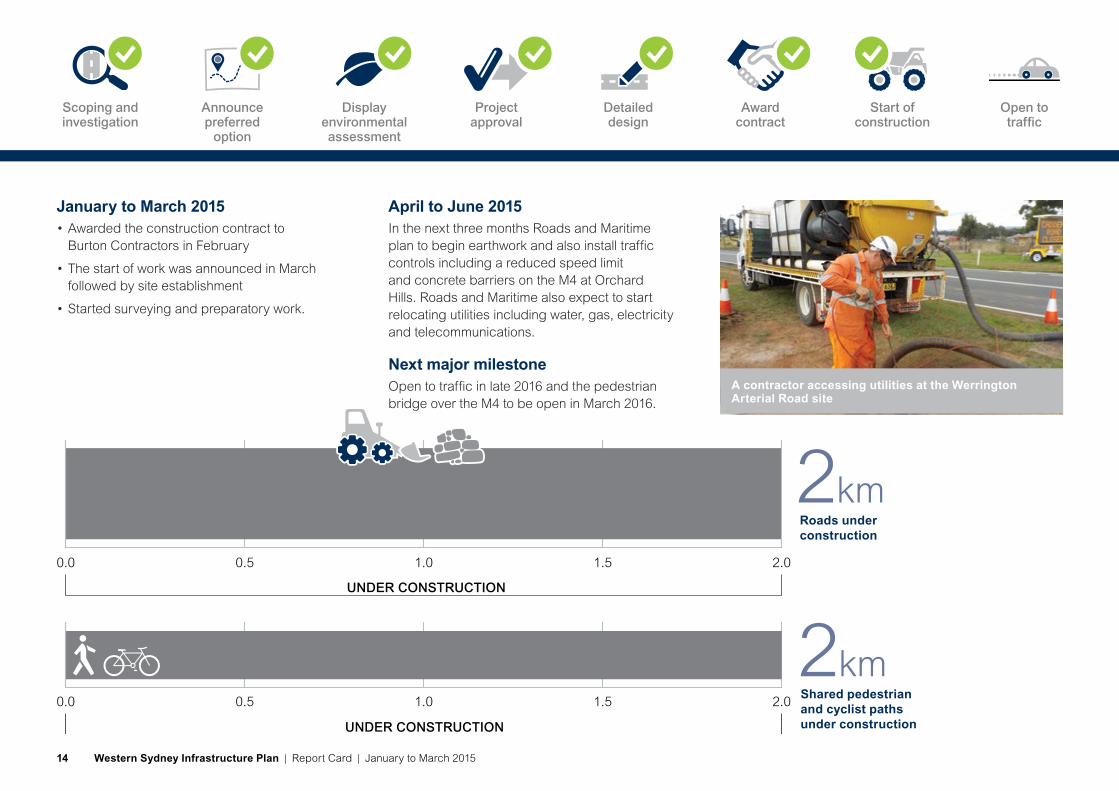
January to March 2015• Awarded the construction contract to
Burton Contractors in February
• The start of work was announced in March followed by site establishment
• Started surveying and preparatory work.
April to June 2015In the next three months Roads and Maritime plan to begin earthwork and also install traffic controls including a reduced speed limit and concrete barriers on the M4 at Orchard Hills. Roads and Maritime also expect to start relocating utilities including water, gas, electricity and telecommunications.
Next major milestoneOpen to traffic in late 2016 and the pedestrian bridge over the M4 to be open in March 2016.
2kmShared pedestrian and cyclist paths under construction
0.0 0.5 1.0 1.5 2.0
UNDER CONSTRUCTION
0.0 0.5 1.0 1.5 2.0
2kmRoads underconstruction
UNDER CONSTRUCTION
A contractor accessing utilities at the Werrington Arterial Road site
Open to traffic
Scoping and investigation
Announce preferred
option
Display environmental assessment
Project approval
Detailed design
Award contract
Start of construction
Western Sydney Infrastructure Plan | Report Card | January to March 201514

Roads in final design
Stage 2 is 4.3km from King Street, Rossmore to The Northern Road, Bringelly. Roads and Maritime is finalising detailed design with construction expected to start in late 2016. Roads and Maritime aim for the project to be open to traffic in late 2018.
Approval for this project was given at the same time as the Bringelly Road upgrade Stage 1.
Features and benefitsBringelly Road upgrade Stage 2 will also have:
• New traffic lights at four existing intersections with designated right and left turning lanes
• A new bridge at South Creek.
Progress• Roads and Maritime spent $668,000 on the project
in the third quarter. Total expenditure to date is $2.1 million. Forecast total expenditure to the end of this financial year is $3.6 million
• 4.3km of road to be built
• 4.2km of shared pedestrian and cyclist path to be built
• Seven intersections to be built.
Bringelly Road upgrade Stage 2
Castle Hill
Epping
Blacktown
Mt Druitt
Chullora
Parramatta
MacquariePark
Strathfield
Hurstville
Prairiewood
Leppington
Burwood
LiverpoolBankstown
St Marys
Cabramatta
Penrith
Sutherland Cronulla
Campbelltown
Miranda
Narellan
Camden
Heathcote
East HillsPrestons
LeppingtonNorth
M4
M4
M7
M5
M2
M31
Elizabeth Drive
Great Western Highway
King Georges R
oad
Bringelly Road
Narellan Road
Camde
n Va
lley
Way
M7
WerringtonArterial Road
The
Nor
ther
n R
oa
d
The
Northern
Road
The N
orthern Road
Stage 2
Project snapshotProject value for Stages 1 and 2: $509 million
Design contractor: URS Australia Pty Ltd
Expected start of construction: Late 2016
Expected to be open to traffic: Late 2018
Australian Government contribution: 80 per cent
NSW Government contribution: 20 per cent
Western Sydney Infrastructure Plan | Report Card | January to March 2015 15

January to March 2015• Continued to work on finalising the detailed
road design
• Utility relocation design progressed with Endeavour Energy, Sydney Water, Telstra and NBN Co
• Liaised with the NSW Department of Education and Communities and bus operators to finalise Rossmore Public School drop off areas and car parking.
April to June 2015In the next three months detailed design will progress. Roads and Maritime will continue carrying out land valuations and property acquisitions.
Next major milestoneDetailed design is due to be completed in the next quarter. Property acquisition will continue and once complete, construction tenders will be issued with the contract expected to be awarded in 2016.
7 Intersectionsbeing built
Bringelly Road, Bringelly
Scoping and Announce Display Project Detailed Award Start of Open to investigation preferred environmental approval design contract construction traffic
option assessment
Western Sydney Infrastructure Plan | Report Card | January to March 201516

Roads in final design
Stage 1 is 3.3km between Old Northern Road, Narellan and Peter Brock Drive, Oran Park.
Roads and Maritime displayed the concept design and Review of Environmental Factors in October 2012. Detailed design is now complete and tenders for construction are expected to be called in mid-2015.
The grade separated Bringelly Road and The Northern Road Interchange will be delivered as part of the Bringelly Road and The Northern Road upgrades.
Benefits and featuresIt will have the safety, capacity and reliability improvements that are on all Western Sydney Infrastructure Plan roads and will also deliver access to future South West Growth Centre precincts along The Northern Road.
The Northern Road upgrade Stage 1 will also have:
• 80km/h speed limit
• Traffic light improvements at three intersections
• Duplication of the bridge over Narellan Creek.
The Northern Road upgrade Stage 1
Project snapshotProject value Stages 1 to 4: $1.6 billion
Design consultant: GHD Pty Ltd
Expected start of construction: Late 2015
Expected to be open to traffic: Early 2018
Australian Government contribution: 80 per cent
NSW Government contribution: 20 per cent
Castle Hill
Epping
Blacktown
Mt Druitt
Chullora
Parramatta
MacquariePark
Strathfield
Hurstville
Prairiewood
Leppington
Burwood
LiverpoolBankstown
St Marys
Cabramatta
Penrith
Sutherland Cronulla
Campbelltown
Miranda
Narellan
Camden
Heathcote
East HillsPrestons
OranPark
M4
M4
M7
M5
M2
M31
Elizabeth Drive
Great Western Highway
King Georges R
oad
Bringelly Road
Narellan Road
Camde
n Va
lley
Way
Th
e Nor thern R
oad
The
Nor
the
rn R
oad
M7
WerringtonArterial Road
The
Nor
ther
n R
oa
d
Stage 1
Western Sydney Infrastructure Plan | Report Card | January to March 2015 17
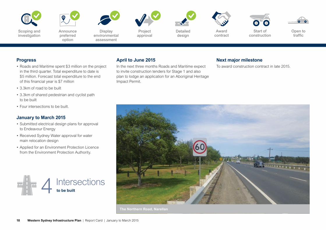
Progress• Roads and Maritime spent $3 million on the project
in the third quarter. Total expenditure to date is $5 million. Forecast total expenditure to the end of this financial year is $7 million
• 3.3km of road to be built
• 3.3km of shared pedestrian and cyclist path to be built
• Four intersections to be built.
January to March 2015• Submitted electrical design plans for approval
to Endeavour Energy
• Received Sydney Water approval for water main relocation design
• Applied for an Environment Protection Licence from the Environment Protection Authority.
April to June 2015In the next three months Roads and Maritime expect to invite construction tenders for Stage 1 and also plan to lodge an application for an Aboriginal Heritage Impact Permit.
Next major milestoneTo award construction contract in late 2015.
to be built4 Intersections
The Northern Road, Narellan
Scoping and investigation
Announce preferred
option
Display environmental assessment
Project approval
Detailed design
Award contract
Start of construction
Open to traffic
Western Sydney Infrastructure Plan | Report Card | January to March 201518

Roads in final design
Stage 2 is about 10km between Peter Brock Drive, Oran Park and Mersey Road, Bringelly. It currently does not include the proposed Bringelly Road and The Northern Road Interchange at Bringelly as this is under development as a grade separated interchange.
Refer to page 27 for further information about this interchange. Detailed design for Stage 2 is being carried out in consultation with stakeholders and the community.
Benefits and featuresThe Northern Road upgrade Stage 2 will also:
• Upgrade to traffic lights at nine intersections and deliver improvements to six others
• Duplicate the bridge over Thompsons Creek for northbound traffic and replace the existing bridge for southbound movement.
The Northern Road upgrade Stage 2
Thompson Creek Bridge, The Northern Road, Bringelly
Project snapshotProject value Stages 1 to 4: $1.6 billion
Design contractor: GHD Pty Ltd
Expected start of construction: Mid 2016
Expected to be open to traffic: Mid 2019
Australian Government contribution: 80 per cent
NSW Government contribution: 20 per cent
Castle Hill
Epping
Blacktown
Mt Druitt
Chullora
Parramatta
MacquariePark
Strathfield
Hurstville
Prairiewood
Leppington
Burwood
LiverpoolBankstown
St Marys
Cabramatta
Penrith
Sutherland Cronulla
Campbelltown
Miranda
Narellan
Camden
Heathcote
East HillsPrestons
M4
M4
M5
M2
M31
Elizabeth Drive
Great Western Highway
King Georges R
oad
Bringelly Road
Narellan Road
Camde
n Va
lley
Way
The
Nor
ther
n R
oa
d
M7
WerringtonArterial Road
The
Nor
ther
n R
oa
d
Stage 2
OranPark
Western Sydney Infrastructure Plan | Report Card | January to March 2015 19

Progress• Roads and Maritime spent $3.9 million on the project
in the third quarter. Total expenditure to date is $4.6 million. Forecast total expenditure to the end of this financial year is $5.5 million
• About 10km of road to be built
• 10km of shared pedestrian and cyclist path to be built
• Nine intersections with traffic lights to be built and a further six intersections to be upgraded.
January to March 2015• Continued to finalise detailed design
• Continued to do property valuations and send letters to owners
• A large area of contaminated land was cleaned up.
April to June 2015In the next three months Roads and Maritime will progress detailed design and prepare updates for community consultation.
Next major milestoneComplete detailed design and construction contract to be awarded in mid 2016.
to be built15Intersections
Roundabout at the intersection of The Northern Road, Badgerys Creek Road and Dart Road, Bringelly Culvert at Lowes Creek, Bringelly
Scoping and investigation
Announce preferred
option
Display environmental assessment
Project approval
Detailed design
Award contract
Start of construction
Open to traffic
Western Sydney Infrastructure Plan | Report Card | January to March 201520

Roads in planning
Stage 3 is between Elizabeth Drive at Luddenham and the M4 Motorway at Orchard Hills. It is planned to generally follow the existing road alignment and be about 9km.
It is still in planning so the road design, project limits and scope of work at the M4 interchange and north of the interchange is not yet confirmed.
Benefits and features It will have the safety, capacity and reliability improvements that are on all Western Sydney Infrastructure Plan roads and will also deliver access to the Broader Western Sydney Employment Area and growth area developments.
Progress• Roads and Maritime spent $280,000 on the project
in the third quarter. Total expenditure to date is $403,000. Forecast total expenditure to the end of this financial year is $1 million
• 9.5km of road to be built
• 9.5km of shared pedestrian and cyclist path to be built
• 19 intersections to be built.
Castle Hill
Epping
Blacktown
St Marys
Chullora
Parramatta
MacquariePark
Strathfield
Hurstville
Prairiewood
Leppington
Burwood
LiverpoolBankstown
Cabramatta
Penrith
Sutherland Cronulla
Campbelltown
Miranda
Narellan
Camden
Heathcote
East HillsPrestons
OranPark
M4
M4
M5
M2
M31
Elizabeth Drive
Great Western Highway
King Georges R
oad
Bringelly Road
Narellan Road
Camde
n Va
lley
Way
The
Nor
ther
n R
oa
d
M7
The
Nor
ther
n R
oad
Stage 3
The Northern Road upgrade Stage 3
Project snapshotProject value Stages 1 to 4: $1.6 billion
Design consultant: Not appointed yet
Expected start of construction: late 2017
Expected to be open to traffic: late 2019
Australian Government contribution: 80 per cent
NSW Government contribution: 20 per cent
Western Sydney Infrastructure Plan | Report Card | January to March 2015 21

January to March 2015• Preliminary environmental investigation
work completed
• Started development of strategic design options
• Confirmed the preferred design option
• Started survey work.
April to June 2015In the next three months Roads and Maritime plan to complete survey work, start new environmental investigation work and continue to develop the preferred option, including an access strategy for local roads and properties.
Next major milestoneThe concept design and access strategy for the preferred option will be prepared for community consultation in mid-2015.
The M4 westbound exit ramp approaching The Northern Road, Orchard Hills
to be built19Intersections
Glenmore Parkway, Glenmore Park
Scoping and investigation
Announce preferred
option
Display environmental assessment
Project approval
Detailed design
Award contract
Start of construction
Open to traffic
Western Sydney Infrastructure Plan | Report Card | January to March 201522
Roads in planning
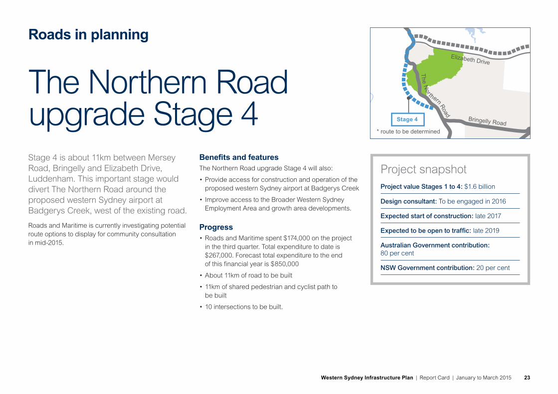
Stage 4 is about 11km between Mersey Road, Bringelly and Elizabeth Drive, Luddenham. This important stage would divert The Northern Road around the proposed western Sydney airport at Badgerys Creek, west of the existing road.
Roads and Maritime is currently investigating potential route options to display for community consultation in mid-2015.
Benefits and features The Northern Road upgrade Stage 4 will also:
• Provide access for construction and operation of the proposed western Sydney airport at Badgerys Creek
• Improve access to the Broader Western Sydney Employment Area and growth area developments.
Progress• Roads and Maritime spent $174,000 on the project
in the third quarter. Total expenditure to date is $267,000. Forecast total expenditure to the end of this financial year is $850,000
• About 11km of road to be built
• 11km of shared pedestrian and cyclist path to be built
• 10 intersections to be built.
The Northern Road upgrade Stage 4
Castle Hill
Epping
Blacktown
Mt Druitt
Chullora
Parramatta
MacquariePark
Strathfield
Hurstville
Prairiewood
Leppington
Burwood
LiverpoolBankstown
St Marys
Cabramatta
Penrith
Sutherland Cronulla
Campbelltown
Miranda
Narellan
Camden
Heathcote
East HillsPrestons
OranPark
M4
M4
M5
M2
M31
Elizabeth Drive
Great Western Highway
King Georges R
oad
Bringelly Road
Narellan Road
Camde
n Va
lley
Way
M7
The
Nor
ther
n R
oad
Th
e Nor thern R
oad
* route to be determined
Stage 4
Project snapshotProject value Stages 1 to 4: $1.6 billion
Design consultant: To be engaged in 2016
Expected start of construction: late 2017
Expected to be open to traffic: late 2019
Australian Government contribution: 80 per cent
NSW Government contribution: 20 per cent
Western Sydney Infrastructure Plan | Report Card | January to March 2015 23

January to March 2015• Preliminary environmental investigation work
was completed
• Started investigating possible route options
• Awarded a contract for strategic utility investigation work and started this work.
April to June 2015In the next three months Roads and Maritime will continue to work on the short listed route options and expect to begin field investigation work.
Next major milestoneDisplay route options for community consultation in mid-2015 and announce preferred option in late 2015.
Luddenham Progress Hall on The Northern Road, Luddenham
to be built10Intersections
Luddenham Town Centre, Luddenham
Scoping and investigation
Announce preferred
option
Display environmental assessment
Project approval
Detailed design
Award contract
Start of construction
Open to traffic
Western Sydney Infrastructure Plan | Report Card | January to March 201524

Roads in planning
A new $1.2 billion motorway is proposed to connect the M7 Motorway near Cecil Park to The Northern Road near Luddenham to provide access and traffic capacity for the proposed western Sydney airport at Badgerys Creek.
The 14km motorway would be built as a four lane road with capacity for six lanes in the future.
The preferred route alignment is expected to be generally parallel to Elizabeth Drive. Roads and Maritime will consult with the community at important stages during the project’s development to ensure the best possible outcome.
Benefits• Provide direct access from the M7 to the proposed
western Sydney airport and enhanced access to the growth centre and Broader Western Sydney Employment Area
• Improve the connection between the M7 and the upgraded The Northern Road to benefit road users across western and south western Sydney
• Improve road freight movement to key commercial centres and reduce congestion costs to business and the community.
Features• Grade separated interchanges at the M7
Motorway, the proposed airport access and at The Northern Road.
The M12 Motorway
Castle Hill
Epping
Blacktown
Mt Druitt
Chullora
Parramatta
MacquariePark
Strathfield
Hurstville
Prairiewood
Leppington
Burwood
LiverpoolBankstown
St Marys
Cabramatta
Penrith
Sutherland Cronulla
Campbelltown
Miranda
Narellan
Camden
Heathcote
East HillsPrestons
OranPark
M4
M4
M5
M2
M31
Elizabeth Drive
Great Western Highway
King Georges R
oad
Bringelly Road
Narellan Road
Camde
n Va
lley
Way
The
Nor
ther
n R
oa
d
M7
The
Nor
ther
n R
oad
* route to be determined
Project snapshotProject value: $1.2 billion
Design consultant: Not appointed yet
Expected start of construction: 2020
Expected to be open to traffic: 2024
Australian Government contribution: 80 per cent
NSW Government contribution: 20 per cent
The project scope will be updated as the design progresses through the phases from strategic to concept and then detailed design.
Western Sydney Infrastructure Plan | Report Card | January to March 2015 25

Progress• Roads and Maritime spent $174,000 on the project
in the third quarter. Total expenditure to date is $407,000. Forecast total expenditure to the end of this financial year is $600,000
• 14km of road to be built
• 14km of shared pedestrian and cyclist path to be built
• Three interchanges to be built.
to be built3 Intersections
January to March 2015• Carried out preliminary environmental investigation
work and prepared tender documents.
April to June 2015In the next three months Roads and Maritime expect to start developing strategic route options and prepare for community consultation in mid-2015.
Next major milestoneDisplay possible route options in early 2016 and announce preferred option in late 2016.
Proposed M12 Motorway study area
Scoping and investigation
Announce preferred
option
Display environmental assessment
Project approval
Detailed design
Award contract
Start of construction
Open to traffic
Western Sydney Infrastructure Plan | Report Card | January to March 201526

Roads in planning
An upgrade for this intersection was previously approved as part of The Northern Road upgrade.
A grade separated interchange is now proposed at the intersection of Bringelly Road and The Northern Road as part of the Western Sydney Infrastructure Plan. Roads and Maritime is considering route alignment options for further design and environmental assessment.
Progress• Roads and Maritime spent $29,000 on the project
in the third quarter. Total expenditure to date is $29,000. Forecast total expenditure to the end of this financial year is $325,000
• 1km of shared pedestrian and cyclist path to be built
• Two intersections to be built.
Castle Hill
Epping
Blacktown
Mt Druitt
Chullora
Parramatta
MacquariePark
Strathfield
Hurstville
Prairiewood
Leppington
OranPark
Burwood
LiverpoolBankstown
St Marys
Cabramatta
Penrith
Sutherland Cronulla
Campbelltown
Miranda
Narellan
Camden
Heathcote
East HillsPrestons
M4
M7
M5
M2
M31
Elizabeth Drive
Great Western Highway
King Georges R
oad
Bringelly Road
Narellan Road
Camde
n Va
lley
Way
Th
e Nor thern R
oad
M7
Bringelly Road and The Northern Road Interchange
Intersection at Bringelly Road and The Northern Road, Bringelly
Western Sydney Infrastructure Plan | Report Card | January to March 2015 27

January to March 2015• Preliminary environmental investigation started
• Identified and started developing strategic design options.
April to June 2015To identify and develop a preferred option, including an access strategy for local roads and properties, and start environmental investigation work.
Roads and Maritime expect to begin concept design for the preferred option and prepare information for community consultation in mid-2015.
Next major milestoneDisplay preferred option for community consultation in mid-2015 and the Review of Environmental Factors in late 2015.
to be built2 Intersections
Intersection at Greendale Road and The Northern Road, Bringelly Bringelly Village, Bringelly
Scoping and investigation
Announce preferred
option
Display environmental assessment
Project approval
Detailed design
Award contract
Start of construction
Open to traffic
Western Sydney Infrastructure Plan | Report Card | January to March 201528

Roads in planningCastle Hill
Epping
Blacktown
Mt Druitt
Chullora
Parramatta
MacquariePark
Strathfield
Hurstville
Prairiewood
Leppington
OranPark
Burwood
LiverpoolBankstown
St Marys
Cabramatta
Penrith
Sutherland Cronulla
Campbelltown
Miranda
Narellan
Camden
Heathcote
East HillsPrestons
GlenbrookM4
M7
M5
M2
M31
Elizabeth Drive
Great Western Highway
The
Nor
ther
n R
oa
d
King Georges R
oad
Bringelly Road
Narellan Road
Camde
n Va
lley
Way
Th
e Nor thern R
oad
M7
In March 2015, the Australian and NSW governments announced $5 million funding as part of the Western Sydney Infrastructure Plan to upgrade the intersection of Ross Street and the Great Western Highway, Glenbrook.
The objective is to manage congestion and improve safety. Traffic lights are being considered for this intersection.
Preliminary discussions are being carried out with Blue Mountains City Council to progress the project. The community will be kept informed at key phases of the project.
Glenbrook intersection upgrade
Intersection at Ross Street and the Great Western Highway, Glenbrook
Western Sydney Infrastructure Plan | Report Card | January to March 2015 29

The Australian Government has funded a $200 million Local Roads Package as part of the Western Sydney Infrastructure Plan. This will allow local councils to deliver targeted road improvement projects to provide local transport connections in western Sydney. The funding will be announced in three rounds.
Successful round one projects were announced in late 2014. Roads and Maritime expect to spend about $32.5 million on round one of this program during the next two years to 30 June 2016.
Councils will be invited by the Australian Government to submit proposals for round two funding in the near future.
Round one projects
The Northern Road and Erskine Park Road intersection upgrade studiesPenrith City Council was granted $1.1 million for a traffic, safety and scoping study to identify issues and options to upgrade a number of intersections on The Northern Road. These are between the M4 Motorway and the Great Western Highway, South Penrith and on Erskine Park Road between the M4 Western Motorway and Mamre Road, Erskine Park.
Council has awarded contracts to Jacobs Group Australia Pty Ltd to carry out traffic modelling work on The Northern Road and to SMEC Australia Pty Ltd to do traffic modelling on Erskine Park Road.
Local Roads Package
Erskine Park Road near Explorers Way through to the M4 Motorway interchange
Western Sydney Infrastructure Plan | Report Card | January to March 201530

Cumberland Highway Intersection upgradesFairfield City Council was granted $5.8 million across two years to upgrade the intersections of:
• Cumberland Highway and Hamilton Road
• Cumberland Highway and St Johns Road
• Cumberland Highway and John Street.
The upgrades include local road widening, increased capacity of turning bays and the re-phasing of traffic lights.
Detailed design was completed for the civil work and traffic light designs are being finalised. Work is expected to start in July 2015.
Wetherill Street upgradeFairfield City Council was granted $5.7 million across two years to upgrade Wetherill Street, Wetherill Park between Polding Street and Victoria Street.
The upgrade includes widening Wetherill Street from two lanes to four lanes, straightening the road and providing new traffic lights at the intersection of Wetherill Street and The Horsley Drive.
The project would increase road safety and capacity on Wetherill Street to manage expected future traffic volumes.
Detailed design was completed for the civil work and traffic light designs are being finalised. Work is expected to start in August 2015.
Eagle Vale Drive upgradeCampbelltown City Council was granted $17.5 million across two years to upgrade Eagle Vale Drive, between Badgally Road and Raby Road. The upgrade includes widening to a four lane divided road.
Other elements include:
• New kerb and gutter and central median
• A shared pedestrian and cyclist path connecting regional routes
• New traffic lights and street lighting
• New storm water drainage with water quality improvement.
Tenders were advertised in March 2015.
Local Roads Package
Eagle Vale Drive, Eagle ValeWetherill Street, Smithfield West, looking north from Polding Street
Intersection at St Johns Road and Cumberland Highway, Canley Heights
Western Sydney Infrastructure Plan | Report Card | January to March 2015 31

Argyle Street/Camden Valley Way Corridor upgrade – Stage 1Camden Council was granted $2.14 million across two years to build new traffic lights at the intersection of Argyle Street and Oxley Street, Camden. The project will replace the marked pedestrian crossing with a traffic light pedestrian crossing on Argyle Street west of Hill Street, Camden. The tender process is under way.
Argyle Street/Camden Valley Way upgrade study – Stage 2Camden Council was granted $150,000 for a study to identify future road improvement opportunities along Camden Valley Way between the Camden Town Centre and The Northern Road. A request for quotes to carry out the study was issued in March 2015.
Argyle Street/Camden Valley Way/Macarthur Road intersection study Camden Council was granted $50,000 to test options and complete a detailed design to improve safety and efficiency at this intersection. GTA Consultants has completed the options testing and a design contract was awarded to J Wyndham Prince.
Local Roads Package
Blacktown
Mt Druitt
Chullora
Parramatta
East Hills
Prairiewood
Bringelly
OranPark
Fairfield
Liverpool
Bankstown
St Marys
EasternCreek
GlenmorePark
Luddenham
Rouse Hill
Penrith
Sutherland
Campbelltown
Minto
Narellan
Camden
Heathcote
Leppington
Greendale
Glenbrook
The Northern Road upgrade $1.6 billion
Diversion of The Northern Road
M12 Motorway $1.2 billionIn planning
M4
M7
M5
M7
M2
M31
Elizabeth Drive
Bringelly Road
Narellan Road
Camde
n Va
lley
Way
The N
orthern R
oad
The
Nor
ther
n R
oad
Proposed western Sydney airport at Badgerys Creek
Werrington Arterial Road $70 million Construction started 2015
Bringelly Road upgrade $509 millionConstruction started 2015
The Northern Road and Erskine Park Road intersection upgrade studies $1.1 million
Ross Street / Great Western Highway intersection upgrade $5 million In planning
Wetherill Street upgrade $5.7 million
Eagle Vale Drive upgrade $17.5 million
Cumberland Highway intersection upgrades $5.8 million
Argyle Street/Camden Valley Way corridor upgrade and studies $2.3 million
Local Roads Package $200 million (Australian Government funded)
Western Sydney Infrastructure Plan
Local Roads Package
Major road projects
Route to be determined
LEGEND
Western Sydney Infrastructure Plan | Report Card | January to March 201532

Roads and Maritime Services
Privacy: Roads and Maritime Services (“RMS”) is subject to the Privacy and Personal Information Protection Act 1998 (“PPIP Act”) which requires that we comply with the Information Privacy Principles set out in the PPIP Act.
All information in correspondence is collected for the sole purpose of assisting in the assessment of this proposal. The information received, including names and addresses of respondents, may be published in subsequent documents unless a clear indication is given in the correspondence that all or par t of that information is not to be published. Otherwise RMS will only disclose your personal information, without your consent, if authorised by the law. Your personal information will be held by Roads and Maritime Services at 59 Darby Street, Newcastle NSW 2300. You have the right to access and correct the information if you believe that it is incorrect.
Western Sydney Infrastructure Plan | Report Card | January to March 2015 33

RMS 15.197
For further information about the Western Sydney Infrastructure Plan visit www.rms.nsw.gov.au/WSIP.
Roads and Maritime Services PO Box 973 Parramatta NSW 2124
T 1800 703 457 (project information line)