report & recommendations
TRANSCRIPT
1
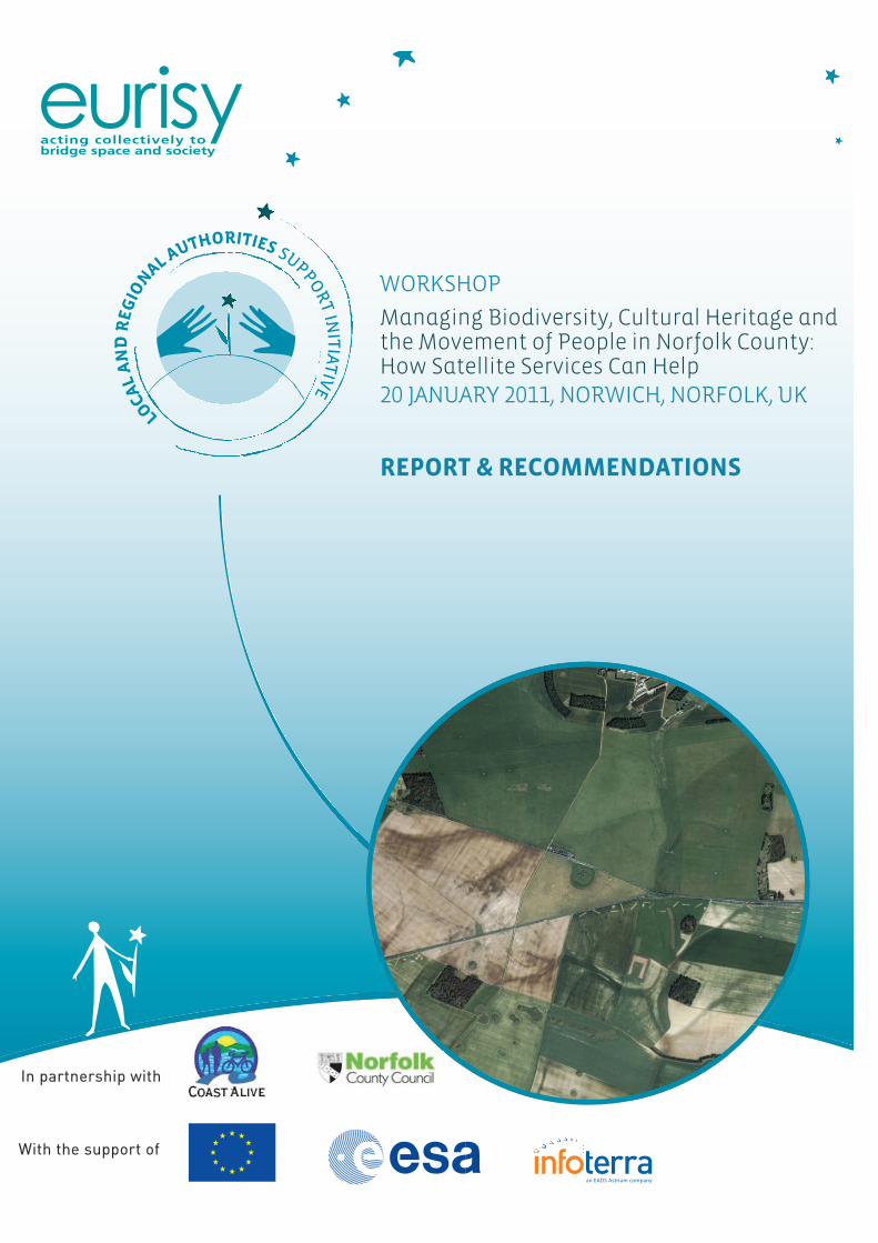
WORKSHOP
Managing Biodiversity, Cultural Heritage and the Movement of People in Norfolk County: How Satellite Services Can Help 20 JANUARY 2011, NORWICH, NORFOLK, UK
REPORT & RECOMMENDATIONS
In partnership with
With the support of
2
Authors & Acknowledgements This report was produced by Eurisy with the kind contribution, assistance and advice from:
David Burrige, ITT
Gareth Crisford, ITT
Clive Farquhar, ITT
Vincent Fintolini, Galateia
Louis-François Guerre, Noveltis
Katie Medcalf, Environment Systems
Vincent Tigny, GIM
3
Contents
1.� Workshop participants _____________________________________________ 4�
2.� Local needs & challenges: an overview ________________________________ 5�a.� Change�management�_____________________________________________________________________�5�
b.� Interaction�with�the�general�public�and�business�_______________________________________________�6�
c.� Coordination�of�stakeholders� ______________________________________________________________�6�
d.� Reporting�obligations;�measuring�progress�and�results� __________________________________________�6�
e.� Specific�Issues� __________________________________________________________________________�7�
f.� Information�Needs�_______________________________________________________________________�7�
g.� Contextual�Constraints� ___________________________________________________________________�8�
3.� Recommendations ________________________________________________ 8�a.�The�case�for�using�satellite�information�to�respond�to�needs�________________________________________�8�
b.�Technical�solution�needed�to�exploit�information� _______________________________________________�11�
c.�Organisational�considerations�for�Norfolk�County�Council�_________________________________________�12�
d.�Some�available�resources� __________________________________________________________________�13�
4
1. Workshop participants
Burrige, David, ITT
Cousins, Gemma, Gaywood Valley Project
Crisford, Gareth, ITT
Evans, Ally, Natural England
Farquhar, Clive, ITT
Feytons, Frédéric, Galateia
Fintolini, Vincent, Galateia
Gillings, Melanie, Norfolk County Council
Green, Sarah, Royal Society for the Protection of Birds
Guerre, Louis-François, Noveltis
Hernandez, Mario, UNESCO
Hoare, Dan Broads Authority
Hoggett, Richard, Norfolk County Council
Horlock, Martin, Norfolk Biodiversity Information Service
Jones, John, Norfolk County Council
Jones, Matthew, East of England Development Agency
Lidstone-Scott, Tim, Peddars Way and Norfolk Coast Path National Trail
Lloyd, Luisa, Norfolk County Council
Lovett, Andrew, University of East Anglia
Medcalf, Katie, Environment Systems
Perkin, Scott, Norfolk Biodiversity Partnership
Reetz, Stefanie, Eurisy
Rérolle, Olivier, Eurisy
Riggs, Will, Environment Agency
Robertson, David, Norfolk County Council
Secara, Teodora, Eurisy
Snook, John Norfolk Climate Change Partnership
Sutton-Croft, Mike Norfolk Non-native Species Initiative
Tigny, Vincent, GIM
Venes, Tim, Norfolk Coast Partnership
5
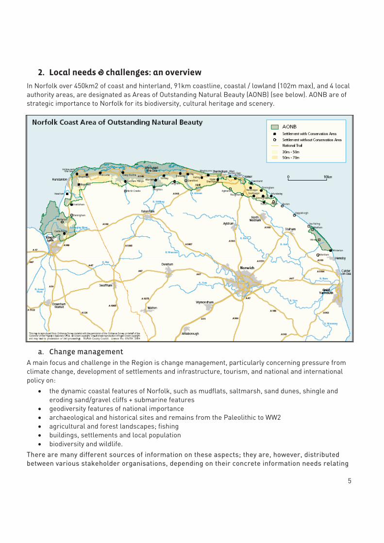
2. Local needs & challenges: an overview
In Norfolk over 450km2 of coast and hinterland, 91km coastline, coastal / lowland (102m max), and 4 local authority areas, are designated as Areas of Outstanding Natural Beauty (AONB) (see below). AONB are of strategic importance to Norfolk for its biodiversity, cultural heritage and scenery.
a. Change management
A main focus and challenge in the Region is change management, particularly concerning pressure from climate change, development of settlements and infrastructure, tourism, and national and international policy on:
� the dynamic coastal features of Norfolk, such as mudflats, saltmarsh, sand dunes, shingle and eroding sand/gravel cliffs + submarine features
� geodiversity features of national importance � archaeological and historical sites and remains from the Paleolithic to WW2 � agricultural and forest landscapes; fishing � buildings, settlements and local population � biodiversity and wildlife.
There are many different sources of information on these aspects; they are, however, distributed between various stakeholder organisations, depending on their concrete information needs relating
6
to their individual missions. Information is not (or insufficiently) shared among all the various stakeholders, and is sometimes lacking or fragmented, or obtained through empirical observations only (e.g. boats in coastal waters).
b. Interaction with the general public and business
Of particular concern to Norfolk stakeholders is the interaction with the general public and local businesses (agriculture, fishing, the energy sector…). Objectives include:
� meeting the demand for recreational activities , in coherence with sustainable development and environmental objectives
� disseminating relevant information supporting visit planning in coherence with sustainable tourist objectives
� supporting a network of amateur recorders and naturalist societies; generating interest in wildlife recording;
� taking into account the needs of business in coherence with environmental protection strategies
Regulating access to the coast, shaping behaviour, mobilising the public and business for environmental protection objectives are sensitive issues. Decisions affecting people and businesses, as well as actions where their support/involvement is needed, require being well-informed and evidence-based.
c. Coordination of stakeholders
A large number of organisations are responsible individually or collectively for the management of biodiversity and cultural heritage. More often than not, they interact with the general public and local businesses in doing so.
For instance, the responsibilities of the Management Group for the AONB (Group comprised of 24 local organisations and Parish representatives) overlap geographically with the Broads Authority, the Wash and North Norfolk Coast European Marine Site Management Scheme, the Wash Estuary Strategy Group.
Another example concerns shared coastal management: Norfolk County Council is responsible for the management of the cliff areas of the coast, whereas the Environment Agency is responsible for flood management in the soft areas.
While organisations work closely together and partly share information1, there is currently no single, interactive, common information platform allowing all or part of the stakeholders to edit, consult and share the information of which they dispose.
Local partners have limited potential for influencing national policy (e.g. coastal adaptation) but aim to develop local plans for adaptation to policy initiatives.
d. Reporting obligations; measuring progress and results
According to European regulations, Norfolk County Council needs to report any loss of 10% or more in protected habitat, and to compensate for the loss by re-creating it. However, stakeholders have noted through empirical observations that habitat may regenerate naturally, thus compensating for habitat-loss
1 Organisations involved in the Management of the AONB refer to an Integrated Landscape Character Guidance for the area, for instance. This tool provides detailed spatial guidance on landscape at a scale of 1:50000, ecological, geodiversity and historic character and sensitivities and recommendations.
7
in certain locations. Reporting obligations are also linked to quality targets for the creation of habitats according to the Biodiversity Action Plan. AONBs’ condition monitoring is reported every 5 years.
Currently there are no objective calculations of habitat loss or precise knowledge of where it is naturally regenerating to support reporting. Further monitoring is needed to assess Woodland Grant Schemes2 effectively.
e. Specific Issues3
� Current poor understanding of key characteristics of relationship between land and sea; � Current poor understanding of landscape condition and objectives for different landscape
types/areas in the area; � Lack of data for monitoring of landscape change; � Current poor understanding and profile of geodiversity in the area � Decline in some key bird species in the North Norfolk Coast Special Protection Area (SPA); � Lack of data on Biodiversity Action Plan (BAP) species and habitats, and other key habitats; � Information required to assess the condition of historic parks and gardens is being developed. � One key issue related to farming, forestry and fishing: lack of good information on location, extent
and condition of key habitats in the area hampers assessment and targeting of contributions from environmental stewardship schemes.
� Decline in some key bird species in the North Norfolk Coast Special Protection Area (SPA) may be linked to pressures from the recreational use of the area.
� Optimisation of public transport systems (one-stop shop info for passenger, traffic and incident information etc.)
� Definitive Map of Public Rights of Way is outdated; Investigating and negotiating a route, accurate mapping of that route is complicated by coastal erosion.
f. Information Needs
� coastal & marine environment/landscape: o beach sediment movements o wave measurement o connectivity of protected areas (land, marine) o potential mineral sites o sea-level rise impact o salt water surges o coastal erosion o new deposits exposed because of coastal erosion
� land use/buildings/infrastructure/settlements:
o socio-economic pressure factors o landowner boundaries (hedges and ditches) o topography
2 The Farm Woodland Premium Scheme is designed to encourage the creation of new woodlands on farms. Its objectives are to enhance the environment through the planting of farm woodlands, in particular to improve the landscape, provide new habitats and increase biodiversity. The annual payments made under this scheme are made to compensate for agricultural revenue foregone. 3 Based on AONB Management Plan 2009-2014 & Workshop Exchanges
8
o light pollution affecting nocturnal landscape o visitor frequency periods on the coast (flow and numbers) o the potential for renewable energy (wind, solar) o the Historic Environment Record (update and enrich) o information on crop marks (buried archaeology) to complete archaeological maps o impact of land use changes to archaeology o impact of coastal erosion on cultural built heritage o heritage inventory for the Gaywood Valley and Broads o water quality, use and extraction o coastal path condition
� habitats & species:
o vegetation quality and assessment of invasive species, (rate of expansion) o habitat fragmentation o suitable areas for habitat re-creation o birds & wildlife monitoring
g. Contextual Constraints
� access to information � funding � staff constraints � political will � public perception of government agencies
3. Recommendations
a. The case for using satellite information to respond to needs
Organisations from Norfolk have need for robust, current environmental information to help with:
� Land use planning, including mitigation measures within the terrestrial environment � Management of the environment and protection of important landscapes, habitats and cultural
heritage � Modeling and protecting the coast and inland waters, in particular The Broads � Forward planning and future scenario operation.
Benefiting from such information implies:
� mapping and characterising items listed in point f above;
� detecting specific features of interest such as buried archaeological features or invasive species;
� monitoring and forecasting of the evolution of the mapped features in time;
� recording and documenting relevant phenomena;
� sharing and disseminating information among professionals but also among the general public.
9
Information4 derived from remote sensing, software applications, mobile devices, modeling techniques and web-based solutions have been used in different areas across the EU in order to address and solve these sorts of issues. Remote sensing provides a repeatable method of collecting and analysing data over wide areas, whether whole county or whole AONB scale. Remote sensing data archives also provide an invaluable source of information about the temporal evolution of features of interest. Furthermore, it can help target field survey methods at the areas most in need of specific input. In these times of financial constraints it is no longer possible to use field survey techniques to record all of the information needed. Satellite-derived information, in combination with other sources, provides a variety of users with access to a key data resource. Having good strategic maps covering the Norfolk area, accessible to stakeholder organisations, as well as the general public through a common Information System will aid planning, modeling, species survey work, mitigation planning after development etc and would quickly fund itself through saving time and effort in the management, dissemination and planning processes. Such an Information System can be achieved through a multipart web-based geographical information system using satellite imagery and air photography, among other data sources. New information from various sources such as field surveys, tourism information, local government, can be used to update the core information.
Regular and ad-hoc information updates can be used to build up an historical database that can be used to monitor changes over time. As mentioned in the report, AONBs conditions require a monitoring frequency of 5 years or less and this is certainly achievable with satellite imagery, supplemented by aerial imagery as and when available. The collection of geo-referenced information on the field can equally and successfully complement the information obtained from remote sensing. All this information can be integrated in an information system and can be supplemented with relevant information such as reports, pictures, videos, sound recordings, etc attached to features of interest present in the various geographical layers.
Some specific needs in Norfolk VS solutions
Landowner boundaries Field boundary features such as hedges can be extracted automatically from remotely sensed imagery. This can be supplied as a one off layer, or combined with other data to give a more complete habitat map.
Habitats A phase 1 habitat map, as implemented in Wales, contains all the vegetated boundary features round individual fields.
Topography Satellite imagery can be used to generate tridimensional representations of the Earth surface. Other remote sensing techniques can be used to derive digital elevation models, such as the so called Digital Terrain Models and Digital Surface Models.
Archaeological features Earth Observation data has been used from many years to map archaeological sites, detect buried
4 Here refers to the result of interpreting raw data collected from sensors mounted on satellites or air-borne to produce quantitative and qualitative information about objects and features on Earth, such as land use, vegetation density, hydrological resources and others.
10
archaeological features, map crop marks, etc.
In South Wales for instance, the habitat map has also been used by archaeologists to locate specific features in relating to Iron Age settlements.
Riverine environment quality / rate of expansion of invasive species
Some invasive species can be clearly seen from satellite imagery and most can be indentified from high resolution aerial imagery. Some of the latest sensors can also help monitor the spread of invasive species, even when they occur on more inaccessible stretches of rive. Furthermore, GPS applications can complement satellite information when used in recording non-native species detected in the field. Species are referenced using electronic forms feeding into the information system. The name of the species, location (GPS coordinates), comments, photos etc. can be recorded using a smartphone interface. This solution can be used either by biodiversity professionals or by volunteer amateur recorders and can be an effective tool in mobilising and educating the general public.
Coastal features Understanding the extent of coastal features and their change over time could be achieved by combining information from various sources. For example, the Environment Agency hold extensive collections of LiDAR data of coastal regions and has done much work looking at features such as dunes, mud flats and salt marshes and eroding cliffs. By joining LiDAR data with a habitat map and recreation statistics, a complete picture begins to emerge of the current state of the coastal zone, and the risks it faces. Further information can be obtained on wave statistics (direction, height), wind statistics (direction, intensity), climatology (average over given periods, extremes)
Storm surges, sea levels, can be simulated with different local meteorological or marine real information (short term), or scenarios (long terms).
Water quality and geo-biochemical states of coastal waters at a given time can be monitored, as well as river plumes.
Estimation of erosion, monitoring of coast line and sediments movements is possible with satellite-derived information as well.
Targeting erosion mitigation and visitor information could save significant amounts of money and preserve the environment.
11
Suitable areas for habitat re-creation By combining a variety of spatial features and habitat information, ecological knowledge can steer analysis to define areas which are suitable for habitat recreation.
Wind and solar energy potential Wind and solar energy potential map can provide real time measurements or simulation of expected yield over a period of time.
Information sharing among stakeholders Interactive information platforms can include web access capacities. Professionals from different user organisations and/or the general public can have selective access to various types of shared information, which greatly improves coordination of stakeholders and can help raise awareness/educate/mobilise the general public.
Maturity of the solutions
All these solutions are already feasible but it is necessary to:
o Adapt them to the local context and needs
o Develop an end-user Information System adapted to Norfolk County Council’s requirements and objectives and forming a collaborative environment
The information used to build and populate the geographic information platform will be produced from in-situ measurements, satellite observations, and numerical models. In situ observations are very precise, but sparse and local. Satellite observations will provide mapping of the physical parameters over up to 20 years of continuous observations of sea-level, waves, wind. The numerical models (e.g. sediment transport, plankton concentration …) will be calibrated and validated against the observations (in situ and satellite), and used to extrapolate the future from the present situation, according to various possible scenarii.
b. Technical solution needed to exploit information
An overall Information System would be required to provide a centralised storage location and access mechanism for all the information, including, for example, the base land use map and its temporal evolution. It is envisaged that the data layers of the system will be derived from a mixture of image products and vector data such as geographic outlines and locations of points of interest. In addition, information under multiple forms and formats (texts, pictures, graphs, videos, 3D models etc) can also be uploaded.
One important data layer to be created from such a remote sensing based analysis system is a baseline habitat map, using standard classification methods such as Phase 1 Habitats or BAP. This can underpin a wide range of monitoring and modeling scenarios. This important dataset helps establish a strong understating of our natural environment and from it other data layers can be developed e.g. landcover. Furthermore, geo-referenced information collected using GPS-applications on smartphones can also feed into the information system.
Selective access to information can be ensured for the different users, according to their different needs for information. An information system could support, for instance:
12
� Import and export of data in various formats
� Connection to external databases and catalogues and dynamic update
� Metadata management,
� Data editing
� Data visualization (including overlay of various layers, temporal animations, etc),
� Data navigation, search, query, printing, etc,
� Data analyses,
The main output of this system would be in the form of maps and environmental reports, indicating, for instance, the evolution of habitat loss and regeneration in time. The reports might be automated or generated on-demand by client tools. Multiple and/or combined maps could be produced to look at changes over time. Other outputs such as video fly-through may also be useful to visualise a particular region.
c. Organisational considerations for Norfolk County Council
� defining a rationale for the use of the information, relative to needs. For instance, a good rationale for a project business case, is to consider a statutory need that can be met by the information, or by considering where the use of such information can solve issues in terms of how information is used today at the county level, or what is missing altogether.
� defining user groups with associated use cases: o stakeholders in Norfolk have quite a variety of objectives and requirements. It is important
to work closely to have a clear picture of collective objectives and priorities in using and sharing information but also to define specific groups and use cases.
o It is important to note also that GIS specialists may not be the users of the information for practical environment monitoring purposes. This distinction is worth making in order to best identify the end-users of the information (e.g. environment manager VS GIS manager).
o by working together and adopting the “collect once use many times” philosophy, partner organisations from Norfolk can establish a powerful collection of data sets and associated mapped products and inventories based on remote sensing, to assist with a wide range of needs.
� agreeing on data sharing and use: where an existing partnership group exists it is normally
possible to work out a data sharing agreement in such as way that a standard base map layer can be produced. Then each partner is free to develop on from this project in whatever way they see fit.
� it would be better value for money for Norfolk if two or three really high quality commercial satellite images are jointly acquired for all to use. The alternative is to test a system with free satellite data, however this always has a very much larger pixel size (that translates to the footprint on the ground) and again base map information will be restricted to large features such as homogeneous fields, artificial surfaces or forests. An example of good quality data would be SPOT satellite imagery with a pixel size of 5 or 10m. Not only will this allow features of these sizes to be identified, but blocks of individual species such as the invasive water pennywort could also be identified. Such data would dramatically increase the ultimate usability and modeling potential of other scenarios and features.
13
� Weighing what can be done in-house and where a service provider is needed. Depending on existing skills, competencies and resources,�Norfolk would benefit from either one organisation purchasing the software and becoming proficient in data-processing techniques or asking a service provider to acquire and provide this robust and ultra-accurate data, ready to be integrated in the information system. A combination of both can be employed. In case Norfolk County Council decides to further internal competencies, domain experts could liaise with the stakeholders to create a series of tools and workflows within the image processing component to allow production of such information products. By creating such bespoke tools, it would be possible for the stakeholders to run the vector or image processing components to create the information products.
� learning from peers If Norfolk require a view of what satellite data can provide it is recommended that they contact users already familiar and using this type of information. Eurisy can supply contact details of regional authorities with experience in this area on request.
� setting up a project and identifying funding opportunities and relevant partnerships On the basis of these recommendations, a collaborative project could be set up involving the different organisations and services providers and submitted to suitable funding agencies.
d. Some available resources
With regard to the existing resources that can be used, various land cover maps have already been created from imagery for the Norfolk region. These include CORINE CLC 1990, 2000 & 2006 and the NERC CEH produced Land Cover Map of GB (1990) & Land Cover Map 2000. Please see (http://www.eea.europa.eu/publications/COR0-landcover) or (http://www.ceh.ac.uk/sci_programmes/BioGeoChem/LandCoverMap2000.html).
Many government organisations in Norfolk already have access to aerial imagery. This can be used in conjunction with satellite imagery to give a multi-scale product.
It is relatively easy to acquire older imagery (some of which is free) and using the object (e.g. habitats, hedges, fields etc) collected from the good quality data set track change back through time. This can give a view of past land use, erosion issues on the coast, water body changes, irrigation changes, ditching etc. Projects could also include pieces of work to look at specific issues such as ‘hindcasting’ and monitoring through time.
The inclusion of Ordnance Survey MasterMap roads, river and urban areas allows such mapping work to target the information not known, rather than collecting information already supplied to local government organisations, should be considered.
For testing a system with free satellite data, the non-profit organisation Planet Action can be considered as a possibility to obtain some SPOT satellite images. Planet Action can provide such data to projects which can successfully demonstrate an expected impact in tackling climate change. The programme is essentially aimed at supporting NGOs who are involved in such projects for non-profit purposes. (see www.planet-action.org)
INTERREG and other sources of European financing are available for regional authorities, some of whom are already using these sources for similar purposes. Eurisy can provide contact details for such regional authorities on request.
Finally, through its User Programme, Eurisy offers in-kind support to Local and Regional Authorities in such projects.