relationship between geology and landform classification ... · pdf fileand natural resources...
TRANSCRIPT
BEPLS Vol 4 [4] March 2015 86 | P a g e ©2015 AELS, INDIA
Bulletin of Environment, Pharmacology and Life Sciences Bull. Env.Pharmacol. Life Sci., Vol 4 [4] March 2015: 86-95 ©2014 Academy for Environment and Life Sciences, India Online ISSN 2277-1808 Journal’s URL:http://www.bepls.com CODEN: BEPLAD Global Impact Factor 0.533 Universal Impact Factor 0.9804
ORIGINAL ARTICLE
Relationship between Geology and landform classification in southeast of Iran
1Marzieh Mokarram 1Marzieh Mokarram (Department of Range and Watershed Management, College of Agriculture
and Natural Resources of Darab, Shiraz University, Darab, Iran, Email: [email protected]
ABSTRACT
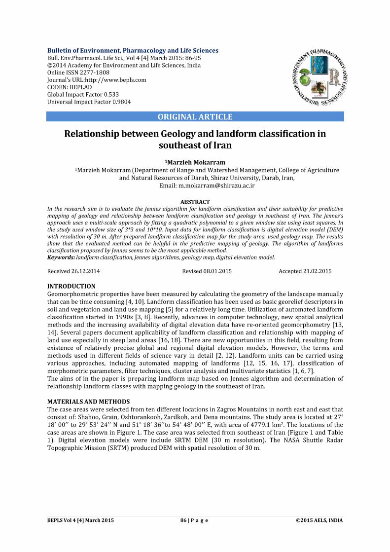
In the research aim is to evaluate the Jennes algorithm for landform classification and their suitability for predictive mapping of geology and relationship between landform classification and geology in southeast of Iran. The Jennes’s approach uses a multi-scale approach by fitting a quadratic polynomial to a given window size using least squares. In the study used window size of 3*3 and 10*10. Input data for landform classification is digital elevation model (DEM) with resolution of 30 m. After prepared landform classification map for the study area, used geology map. The results show that the evaluated method can be helpful in the predictive mapping of geology. The algorithm of landforms classification proposed by Jennes seems to be the most applicable method. Keywords: landform classification, Jennes algorithms, geology map, digital elevation model. Received 26.12.2014 Revised 08.01.2015 Accepted 21.02.2015 INTRODUCTION Geomorphometric properties have been measured by calculating the geometry of the landscape manually that can be time consuming [4, 10]. Landform classification has been used as basic georelief descriptors in soil and vegetation and land use mapping [5] for a relatively long time. Utilization of automated landform classification started in 1990s [3, 8]. Recently, advances in computer technology, new spatial analytical methods and the increasing availability of digital elevation data have re-oriented geomorphometry [13, 14]. Several papers document applicability of landform classification and relationship with mapping of land use especially in steep land areas [16, 18]. There are new opportunities in this field, resulting from existence of relatively precise global and regional digital elevation models. However, the terms and methods used in different fields of science vary in detail [2, 12]. Landform units can be carried using various approaches, including automated mapping of landforms [12, 15, 16, 17], classification of morphometric parameters, filter techniques, cluster analysis and multivariate statistics [1, 6, 7]. The aims of in the paper is preparing landform map based on Jennes algorithm and determination of relationship landform classes with mapping geology in the southeast of Iran. MATERIALS AND METHODS The case areas were selected from ten different locations in Zagros Mountains in north east and east that consist of: Shahoo, Grain, Oshtorankooh, Zardkoh, and Dena mountains. The study area is located at 27º 18′ 00′′ to 29º 53′ 24′′ N and 51º 18′ 36′′to 54º 48′ 00′′ E, with area of 4779.1 km2. The locations of the case areas are shown in Figure 1. The case area was selected from southeast of Iran (Figure 1 and Table 1). Digital elevation models were include SRTM DEM (30 m resolution). The NASA Shuttle Radar Topographic Mission (SRTM) produced DEM with spatial resolution of 30 m.
BEPLS Vol 4 [4] March 2015 87 | P a g e ©2015 AELS, INDIA
Figure 1: Digital Elevation Mountain (DEM) of the study area
Table 1. Characteristics of the cases study
Methods of classification The topographic position index (TPI) [9] used in the study area. This method was further developed by Weiss [19] and Jenness [11]. TPI (Eq. (1)) compares the elevation of each cell in a DEM to the mean elevation of a specified neighborhood around that cell. Mean elevation is subtracted from the elevation value at center.
���� = �� − ∑ �����
�� (1)
where;
��= elevation of the model point under evaluation
��= elevation of grid n = the total number of surrounding points employed in the evaluation
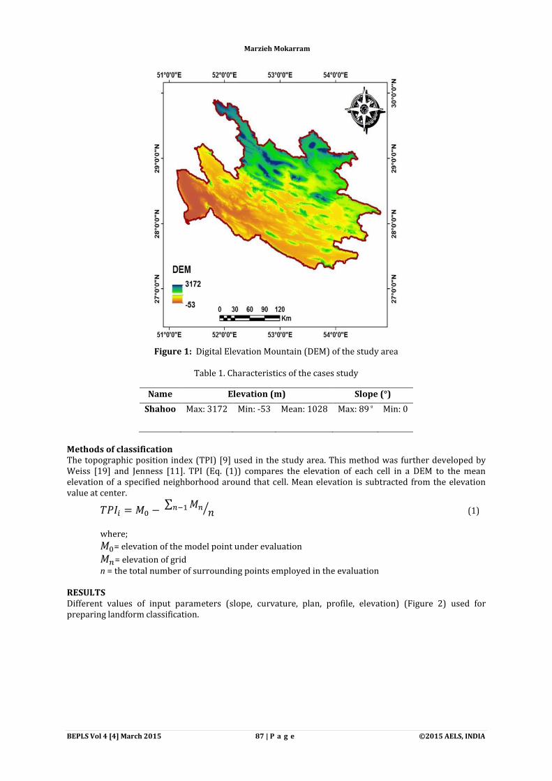
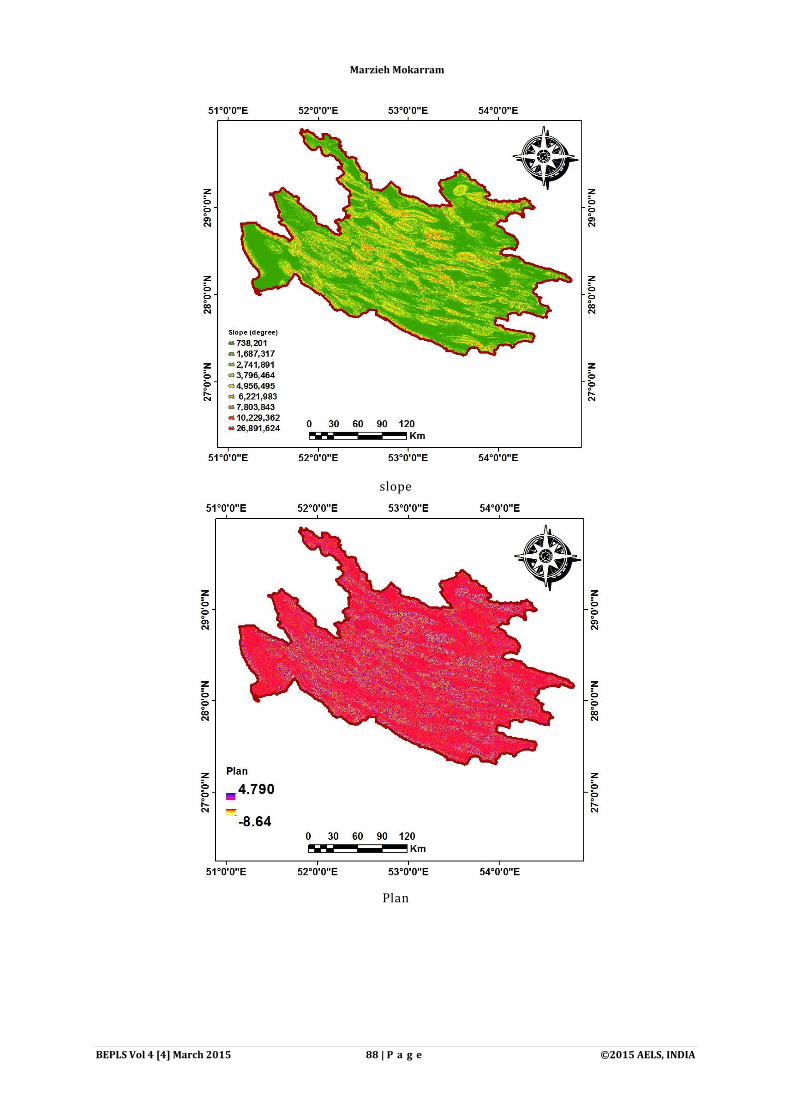
RESULTS Different values of input parameters (slope, curvature, plan, profile, elevation) (Figure 2) used for preparing landform classification.
Name Elevation (m) Slope (°)
Shahoo Max: 3172 Min: -53 Mean: 1028 Max: 89 º Min: 0
Marzieh Mokarram
BEPLS Vol 4 [4] March 2015 88 | P a g e ©2015 AELS, INDIA
slope
Plan
Marzieh Mokarram

BEPLS Vol 4 [4] March 2015 89 | P a g e ©2015 AELS, INDIA
Profile
curvature
Marzieh Mokarram
BEPLS Vol 4 [4] March 2015 90 | P a g e ©2015 AELS, INDIA
DEM
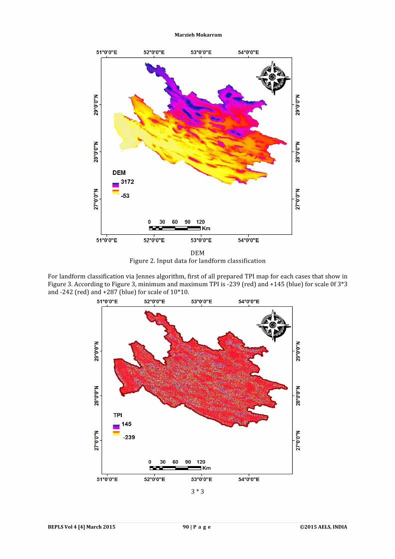
Figure 2. Input data for landform classification For landform classification via Jennes algorithm, first of all prepared TPI map for each cases that show in Figure 3. According to Figure 3, minimum and maximum TPI is -239 (red) and +145 (blue) for scale 0f 3*3 and -242 (red) and +287 (blue) for scale of 10*10.
3 * 3
Marzieh Mokarram

BEPLS Vol 4 [4] March 2015 91 | P a g e ©2015 AELS, INDIA
10 * 10
Figure 3. TPI value for the study area
After prepare TPI map for each of the cases study, the landform classification map were created (Figure 4 and Table 2). Landform classification maps generated based on the computed TIP values are shown in Figure 4. For this method, the classes consist of canyons/ deeply incised streams, midslope drainages/ shallow valleys, upland drainages/headwaters, u-shaped valleys, plains small, open slopes, upper slopes/mesas, local ridges/hills in valleys, mid slope ridges/small hills in plains, mountain tops/high ridges.
Figure 4. Landform classification map
Marzieh Mokarram
BEPLS Vol 4 [4] March 2015
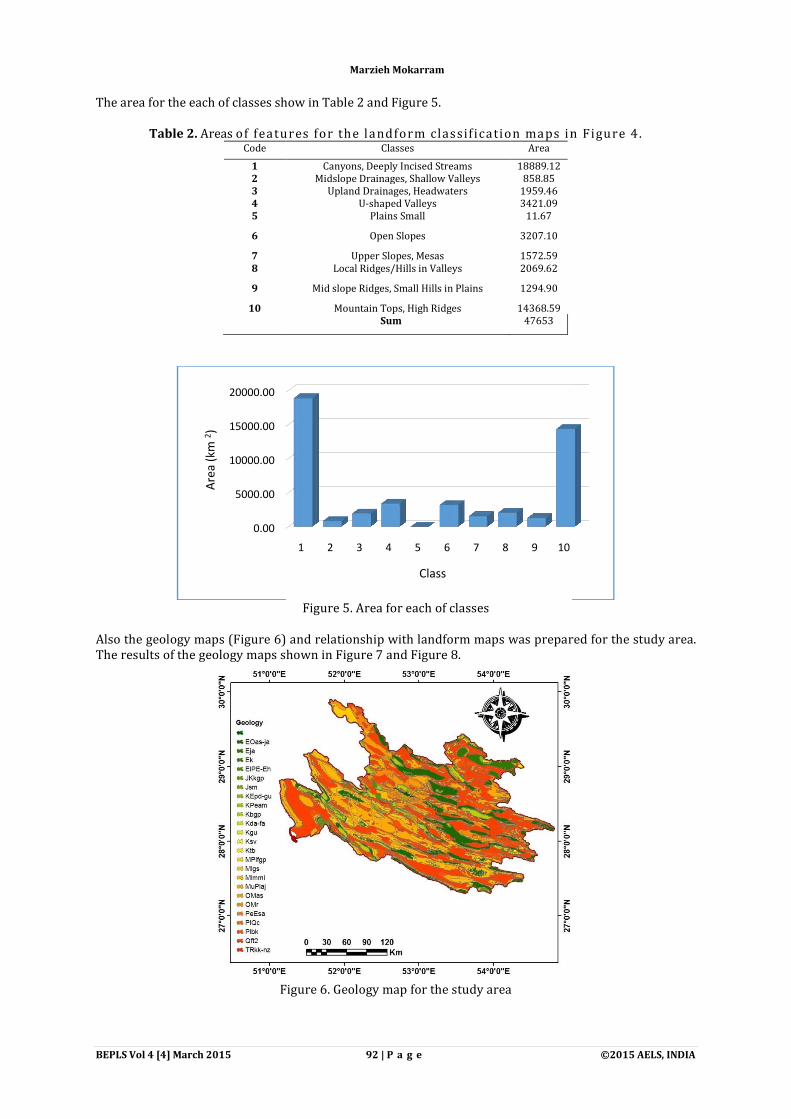
The area for the each of classes show in Table 2 and Figure 5.
Table 2. Areas of features for the landform classif ication maps in Figure 4.Code
1 2 3 4 5
6
7 8
9
10
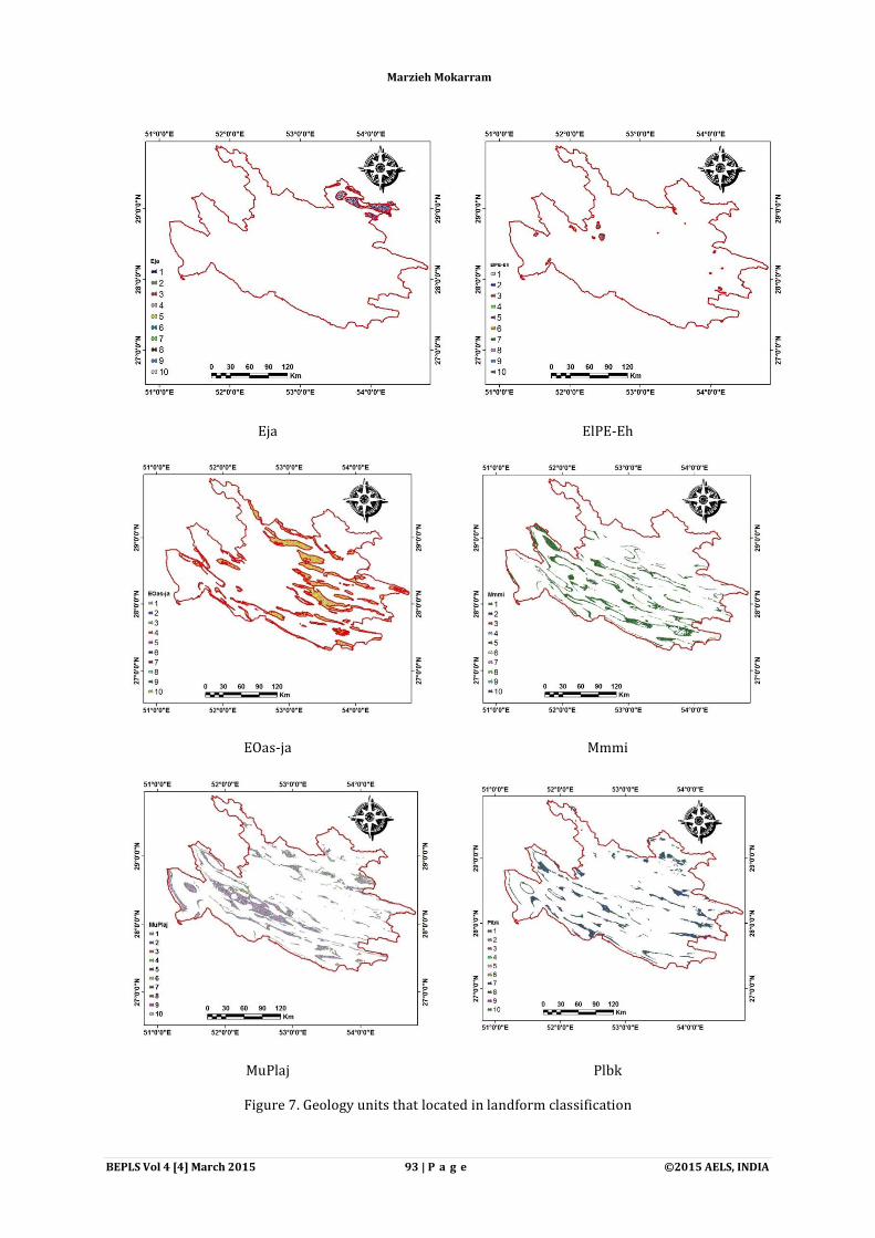
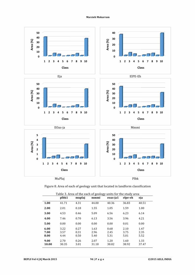
Also the geology maps (Figure 6) and relationship with landform maps was prepared for the study area. The results of the geology maps shown in Figure 7 and Figure 8.
Figure 6. Geology map for the study area
0.00
5000.00
10000.00
15000.00
20000.00
Are
a (k
m 2
)
92 | P a g e
The area for the each of classes show in Table 2 and Figure 5.
of features for the landform classif ication maps in Figure 4.Classes Area
Canyons, Deeply Incised Streams 18889.12 Midslope Drainages, Shallow Valleys 858.85
Upland Drainages, Headwaters 1959.46 U-shaped Valleys 3421.09
Plains Small 11.67
Open Slopes 3207.10
Upper Slopes, Mesas 1572.59 Local Ridges/Hills in Valleys 2069.62
Mid slope Ridges, Small Hills in Plains 1294.90
Mountain Tops, High Ridges 14368.59 Sum 47653
Figure 5. Area for each of classes
Also the geology maps (Figure 6) and relationship with landform maps was prepared for the study area. The results of the geology maps shown in Figure 7 and Figure 8.
Figure 6. Geology map for the study area
1 2 3 4 5 6 7 8 9 10
Class
Marzieh Mokarram
©2015 AELS, INDIA
of features for the landform classif ication maps in Figure 4.
Also the geology maps (Figure 6) and relationship with landform maps was prepared for the study area.
BEPLS Vol 4 [4] March 2015 93 | P a g e ©2015 AELS, INDIA
Eja ElPE-Eh
EOas-ja Mmmi
MuPlaj Plbk
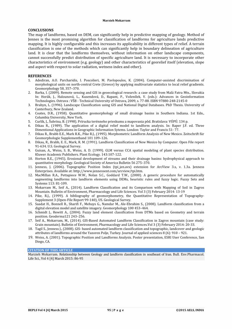
Figure 7. Geology units that located in landform classification
Marzieh Mokarram
BEPLS Vol 4 [4] March 2015
Eja
EOas-ja
MuPlaj
Figure 8. Area of each of geology unit that located in landform classification
Table 3. Area of the each of geology plbk1
1.00 41.71
2.00 2.01
3.00 4.53
4.00 7.46
5.00 0.00
6.00 3.22 7.00 3.57 8.00 4.44
9.00 2.70 10.00 30.35
0
10
20
30
40
50
1 2 3 4 5 6
Are
a (%
)
Class
0
10
20
30
40
50
1 2 3 4 5 6
Are
a (%
)
Class
0
1
2
3
4
5
1 2 3 4 5 6
Are
a (%
)
Class
94 | P a g e
ElPE-Eh
Mmmi
Plbk
Figure 8. Area of each of geology unit that located in landform classification
Table 3. Area of the each of geology units for the study area muplaj mmmi eoas-ja1 elpe-eh eja
4.31 44.00 40.36 36.83 40.51
0.18 1.55 1.05 1.59 1.00
0.46 5.09 6.56 6.23 6.14
0.70 6.13 3.56 3.96 4.21
0.00 0.00 0.00 0.01 0.00
0.27 1.63 0.68 2.10 1.470.31 2.96 2.45 3.75 2.350.50 5.40 5.31 5.01 5.52
0.26 2.07 1.20 1.60 1.333.01 31.18 38.82 38.92 37.47
7 8 9 10
0
10
20
30
40
1 2 3 4 5
Are
a (%
)
Class
7 8 9 10
0
10
20
30
40
50
1 2 3 4 5
Are
a (%
)
Class
7 8 9 10
0
10
20
30
40
50
1 2 3 4 5
Are
a (%
)
Class
Marzieh Mokarram
©2015 AELS, INDIA
Eh
Figure 8. Area of each of geology unit that located in landform classification
eja
40.51
1.00
6.14
4.21
0.00
1.47 2.35 5.52
1.33 37.47
6 7 8 9 10
Class
6 7 8 9 10
Class
6 7 8 9 10
Class
BEPLS Vol 4 [4] March 2015 95 | P a g e ©2015 AELS, INDIA
CONCLUSIONS The map of landforms, based on DEM, can significantly help in predictive mapping of geology. Method of Jennes is the most promising algorithm for classification of landforms for agriculture lands predictive mapping. It is highly configurable and this increases its applicability in different types of relief. A terrain classification is one of the methods which can significantly help in boundary delineation of agriculture land. It is clear that the landforms themselves, without information on other landscape components, cannot successfully predict distribution of specific agriculture land. It is necessary to incorporate other characteristics of environment (e.g. geology) and other characteristics of georelief itself (elevation, slope and aspect with respect to solar radiation, wetness index and other). REFERENCES 1. Adediran, A.O. Parcharidis, I. Poscolieri, M. Pavlopoulos, K. (2004). Computer-assisted discrimination of
morphological units on north-central Crete (Greece) by applying multivariate statistics to local relief gradients. Geomorphology 58, 357–370.
2. Barka, I. (2009). Remote sensing and GIS in geoecological research: a case study from Malá Fatra Mts., Slovakia In: Horák, J., Halounová, L., Kusendová, D., Rapant, P., Voženílek, V. (eds.): Advances in Geoinformation Technologies. Ostrava : VŠB - Technical University of Ostrava, 2009, s. 77-88. ISBN 97880-248-2145-0
3. Brabyn, L. (1996). Landscape Classification using GIS and National Digital Databases. PhD Thesis. University of Canterbury, New Zealand.
4. Coates, D.R., (1958). Quantitative geomorphology of small drainage basins in Southern Indiana. 1st Edn., Columbia University, New York.
5. Curlík, J., Šubrina, B. (1998). Prírucka terénneho prieskumu a mapovania pôd. Bratislava: VÚPÚ. 134 p. 6. Dikau R., (1989). The application of a digital relief model to landform analysis. In: Raper J.F. ed. Three
Dimentional Applications in Geographic Information Sytems. London: Taylor and Francis 51- 77. 7. Dikau R., Brabb E.E., Mark R.K., Pike R.J., (1995). Morphometric Landform Analysis of New Mexico. Zeitschrift für
Geomorphologie Supplementband 101 109–126. 8. Dikau, R., Brabb, E. E., Mark, R. M. (1991). Landform Classification of New Mexico by Computer. Open File report
91-634. U.S. Geological Survey. 9. Guisan, A., Weiss, S. B., Weiss, A. D. (1999). GLM versus CCA spatial modeling of plant species distribution.
Kluwer Academic Publishers. Plant Ecology. 143:107-122. 10. Horton R.E., (1945). Erosional development of streams and their drainage basins: hydrophysical approach to
quantitative morphology. Geological Society of America Bulletin 56 275–370. 11. Jenness, J. (2006). Topographic Position Index (tpi_jen.avx) extension for ArcView 3.x, v. 1.3a. Jenness
Enterprises. Available at: http://www.jennessent.com/arcview/tpi.htm. 12. MacMillan R.A., Pettapiece W.W., Nolan S.C., Goddard T.W., (2000). A generic procedure for automatically
segmenting landforms into landform elements using DEMs, heuristic rules and fuzzy logic. Fuzzy Sets and Systems 113: 81-109.
13. Mokarram M., Seif A., (2014). Landform Classification and its Comparison with Mapping of Soil in Zagros Mountain. Bulletin of Environment, Pharmacology and Life Sciences. Vol 3 (3) February 2014: 13-19
14. Pike, R.J., (1999). A bibliography of geomorphometry, the Quantitative Representation of Topography-Supplement 3 (Open-File Report 99-140), US. Geological Survey.
15. Saadat H., Bonnell R., Sharifi F., Mehuys G., Namdar M., Ale-Ebrahim S., (2008). Landform classification from a digital elevation model and satellite imagery. Geomorphology 100 453–464.
16. Schmidt J., Hewitt A., (2004). Fuzzy land element classification from DTMs based on Geometry and terrain position. Geoderma121 243–256.
17. Seif A., Mokarram, M., (2014). GIS-Based Automated Landform Classification in Zagros mountain (case study: Grain mountain). Bulletin of Environment, Pharmacology and Life Sciences.Vol 3 (3) February 2014: 20-33.
18. Tagil S., Jenness J., (2008). GIS- based automated landform classification and topographic, landcover and geologic attributes of landforms around the Yazoren Polje, Turkey. Journal of applied sciences 8 (6): 910 – 921.
19. Weiss, A. (2001). Topographic Position and Landforms Analysis. Poster presentation, ESRI User Conference, San Diego, CA.
CITATION OF THIS ARTICLE Marzieh Mokarram. Relationship between Geology and landform classification in southeast of Iran. Bull. Env.Pharmacol. Life Sci., Vol 4 [4] March 2015: 86-95
Marzieh Mokarram