regionally connected structural systems: the power of the
TRANSCRIPT

Regionally Connected Structural Systems: the Power of the Big (Continental-Scale) Picture*
James Granath1 and William Dickson
2
Search and Discovery Article #30490 (2017)** Posted March 6, 2017
*Adapted from oral presentation give at AAPG/SPE Africa Energy and Technology Conference, Nairobi City, Kenya, December 5-7, 2016**Datapages © 2017 Serial rights given by author. For all other rights contact author directly.
1Granath & Assoc Consulting Geology, Highlands Ranch, CO, United States ([email protected]) 2Dickson International Geoscience, Houston, TX, United States
Abstract
Beyond offshore West Africa where modern densely sampled data from ships and satellites have played a key role in current understanding of passive margin evolution, Africa is in general rather unevenly known, especially in the subsurface in more remote areas. The GIS-based Exploration Fabric of Africa (EFA, the ‘Purdy project’) was designed to address that problem. It includes structural features such as faults and basin outlines but at a very high and often generalized level, divorced from their underlying genetic linkages. We have undertaken to compile a more detailed tectonic synthesis aimed to integrate understanding of the oceanic margins with the continental realm. This is an overlay to EFA with a variety of public domain, published, non-exclusive, and derivatives of proprietary work at a closer and more detailed level, importantly guided by known patterns of structural styles. Potential field (gravity and magnetic) data provide guidance in locating, extending, and connecting key mapped features; we then rely on the kinematic patterns to predict missing details in a testable interpretation. The result is a detailed structural features map that can function as a framework within which to target and prioritize both conventional and unconventional activity by operators and licensing/regulatory organizations. We illustrate the process in theory and in practice along the Central African Rift System (CARS), where data is sparse. This fault linkage systems approach has flagged underexplored areas where unmapped structure is likely that could, for example, be targeted with hi-resolution geophysical data. A similar system to CARS appears to cross southern Africa from Namibia to Tanzania - a “Southern Trans-African Rift system" or STARS. Exploration in the eastern Owambo Basin resulted in the mapping of a pull-apart basin from depth-to-basement inversion of high-resolution magnetic data and subsequently studied with structural modeling. Thinking in terms of such fault and structural systems, this ‘Kavango Basin’ can be related along strike to the Karoo Basins in Eastern Africa via features such as the Omaruru lineament, implying the possibility of a fairway of extensional basins and shears across the continent that are not obvious in existing low-resolution data. STARS represents a blue-sky frontier concept for both conventional and nonconventional exploration potentially offering new exploration leads, the ultimate objective of big picture work.

Regionally connected structural systems: the power of the big (continental-scale)
picture
James Granath1 , and William Dickson2
1Granath & Assoc Consulting Geology on behalf of Reconnaissance Energy Int’l 2Dickson International Geosciences, Houston, TX, United States
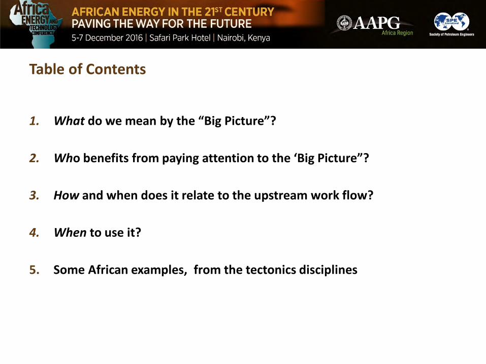
Table of Contents
1. What do we mean by the “Big Picture”?
2. Who benefits from paying attention to the ‘Big Picture”?
3. How and when does it relate to the upstream work flow?
4. When to use it?
5. Some African examples, from the tectonics disciplines

WHAT is The “Big Picture”?Basin-country-region-continental scale view of a play or hydrocarbon system,
including structural, sed/strat, geochemical, or geophysical data.
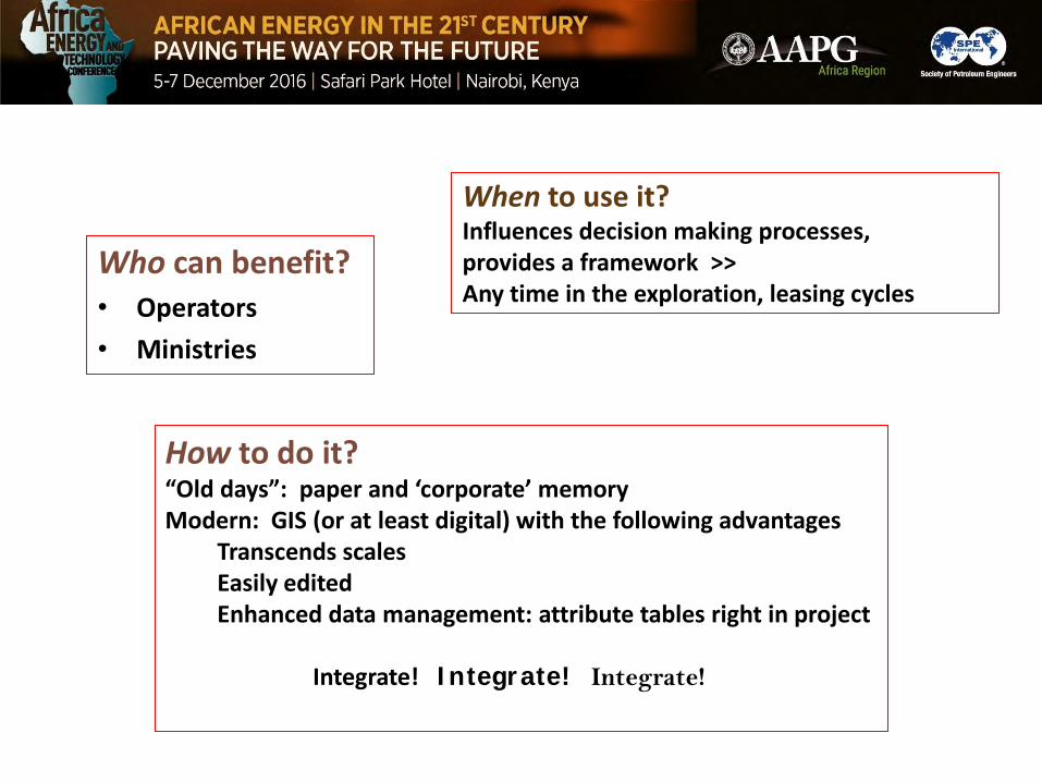
Who can benefit?• Operators
• Ministries
How to do it?“Old days”: paper and ‘corporate’ memoryModern: GIS (or at least digital) with the following advantages
Transcends scalesEasily editedEnhanced data management: attribute tables right in project
Integrate! Integrate! Integrate!
When to use it?Influences decision making processes, provides a framework >>Any time in the exploration, leasing cycles

BASIS OF THE UNDERLYING PROJECT
PURPOSE
To create a continent-wide compilation of African structural elements that is kinematically sound
• Rationale that there has not been a continent-wide tectonically focused data set• Progress in surrounding ocean basins and on continental margins has not been
paralleled onshore
MEDIUM AND COMPONENTS
Purdy Exploration Fabric of Africa (EFAfrica.com), foundation material that is GIS-basedLiterature plus proprietary material available to the authorsOriginal work Continental-scale compilations of potential field data and its inversions
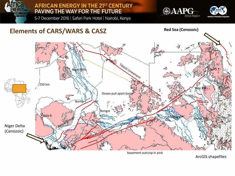
Elements of CARS/WARS & CASZ Red Sea (Cenozoic)
Bida R.
Niger Rifts
Nile Rifts
Muglad RiftMelut Rift
basement outcrop in pink
Niger Delta (Cenozoic)
ArcGIS shapefiles
Doseo pull apart basin
Bongor
Doba
Bornu
250 km

Bending, Side-stepping, & Overlapping-Paralleling Wrench Segments
Bending and Side-stepping:Classic rhombic pull-apartsand uplifts
+-
Paralleling wrenches unpredictable:Largely dependent on cumulative slipand relative propagation direction
Or, how the wrench segments interact along strike.

“Mega-shear” linkage systems
Soft linkages
Hard linkage
Hypothetical illustration of reversal in sense of offset

CARS/CASZ schematic synthesis
43
44
42
41Atbara Rift
initiated at tip
Transcurrent offset dies toward triple junction offshore
NOAA
Plates
http://www.mantleplumes.org
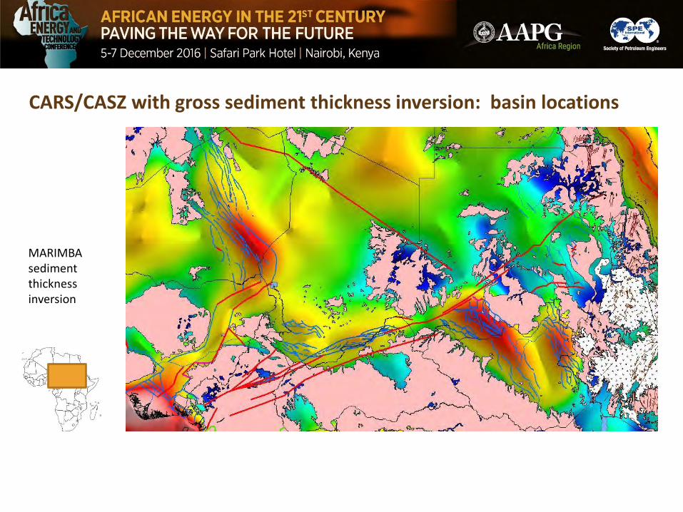
CARS/CASZ with gross sediment thickness inversion: basin locations
MARIMBA sediment thickness inversion

“Southern Trans-African Rift System” (STARS)exposed elements
Karoo Basins
Malawi Rift (EAR)
Pan-African thrust fronts
ArcGIS shapefiles
Damara orogen
Zambezi Belt
Lufilian Arc
Chimaliro FMwembeshi SZ
Omaruru linOtjihorongo thOkahanda lin
Atlantic Ocean
Indian Ocean
Great Dyke
basement outcrop in pink
250 km
OwamboBasin

NEW ELEMENTS of the “Southern Trans-African Rift System” (STARS)
Caprivi Basin, Mapped by Instinct Energy
Kavango Basin, mapped by Earthfield/Reconaissance Energy
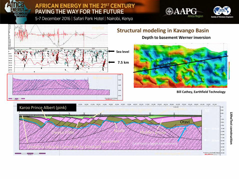
Structural modeling in Kavango BasinDepth to basement Werner inversion
Profile
Vertical exaggeration 2:1
basement
Nosib
Otavi
Mulden groupDwyka tillite
Karoo Prince Albert (pink) Karoo White Hills (green) Cretaceous
Etendeka volcanics (overlain by Kalahari)
Restoration
Bill Cathey, Earthfield Technology
Litho
Tect
con
structio
n
NESW
7.5 km
Sea level
10 km
20 km Earthfield’s depth-to-basement

STARS schematic synthesis
STARS
Porada (1989)
Cape Fold Belt
6
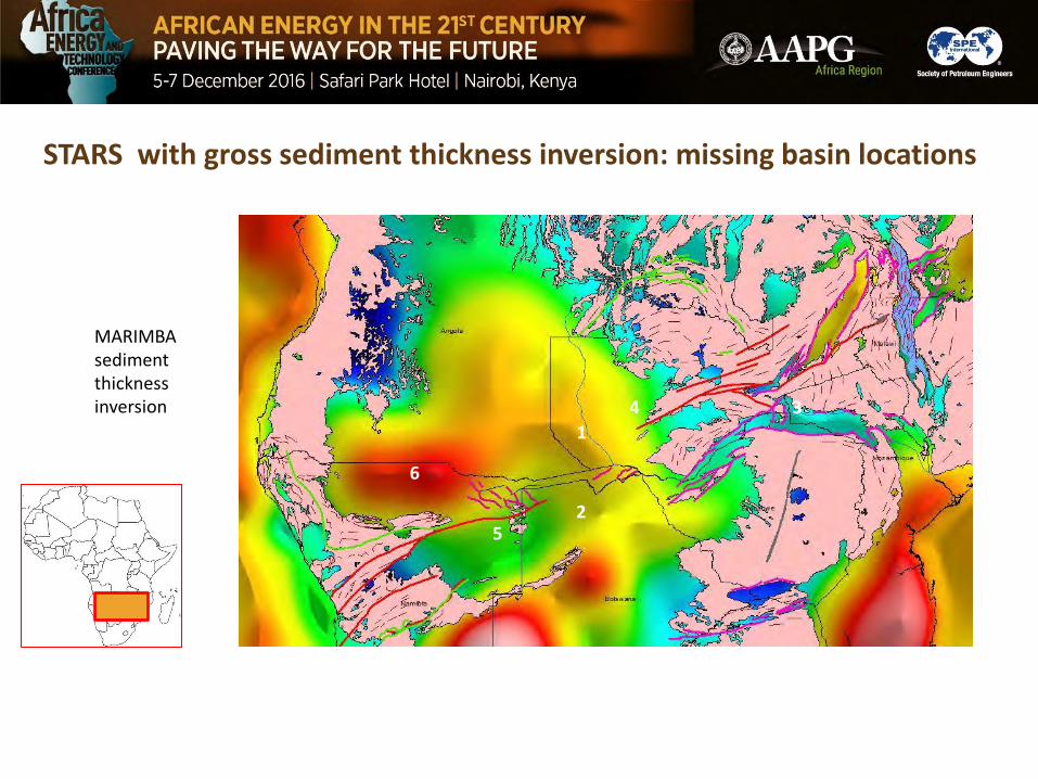
STARS with gross sediment thickness inversion: missing basin locations
MARIMBA sediment thickness inversion
5
1
2
34
6

CONCLUSIONS• “Big Picture” is an integrative way of thinking, useful in exploration
from both the operator and the ministry point of view
• “Big Picture” capable of giving leads to missing tectonic elements
• Intraplate deformation is commonly organized as structural styles or blended structural styles
• The systems can be understood in terms of known structural styles and interplay of the elements of those systems
• Two examples are the well known Central African systems and a less recognized trans-southern Africa system (STARS), recognized as the Karoo system in eastern Africa
• This application of ‘systems structural geology’ can be used to predict missing structural elements or to guide new ventures exploration