region 1 common stand exam and inventory and monitoring
TRANSCRIPT

Region 1 Common Stand Exam and Inventory and Monitoring Protocols
May 2016
APPENDICES

R1 Field Guide – Common Stand Exam Contents Appendices
APPENDICES:
Appendices Contents – R1 CSE Field Guide
A Administrative and Proclaimed National Forest Codes
B District Codes
C State Codes
D County Codes
E Existing Vegetation Composition References and Codes
F Potential Vegetation References
G Potential Vegetation Codes
H List of Species
I Fuel Photo References and Codes
J Fixed-Radius Plot (slope correction; borderline trees)
K Variable-Radius Plot (borderline trees)
L Measuring Diameter
M Point of Diameter Measurement
N Radial Growth and Height Growth
O Measuring Age
P Measuring Height
Q Measuring Crowns
R Damage Categories, Agents, Severity Ratings, and Tree Parts
S Down-Woody Materials
T Tolerances for Region 1 Common Stand Exam
U Fuel Model
V Glossary

R1 Field Guide – Common Stand Exam Administrative and Proclaimed National Forest Codes Appendix A
A-1
Appendix A: Administrative and Proclaimed National Forest Codes
Administrative and Proclaimed National Forest Codes
Admin Number
Administrative Forest Name
Proc
Number Proclaimed Forest Name
02 Beaverhead - Deerlodge 02* Beaverhead
03 Bitterroot 03 Bitterroot
04 Idaho Panhandle 04* Idaho Panhandle
05* Clearwater
08 Custer 08 Custer
02 Beaverhead - Deerlodge 09 Deerlodge
10 Flathead 10 Flathead
11 Gallatin 11 Gallatin
12 Helena 12 Helena
14 Kootenai 14* Kootenai
15 Lewis and Clark 15 Lewis and Clark
16 Lolo 16 Lolo
17 Nezperce Clearwater 17 Nezperce
Note: *Prior to migration to FSVeg, R1 used TSMRS and R1 Edit to manage stand informaton. Those databases did not discern between Administrative and Proclaimed Forest. Therefore, when migrating to FSVeg and FSVeg Spatial, both Administrative and Proclaimed Nation Forest were populated with the Forest number being used in 2000. So, Proclaimed Forest is not necessarily the Congretionally mandated Forest number but the number that was used by the Region in 2000.

R1 Field Guide – Common Stand Exam District Codes Appendix B
B-1
Appendix B: District Codes Record the 2-digit District code associated with the Proclaimed National Forest. These District numbers
should not be updated over time due to consolidation. They are the District numbers that were used
when the Forest stand layer was migrated to FSVeg Spatial in 2010 based on the TSMRS District codes
used in 2005. Refer to appendix B for a list of District Codes.
In order to check the District, associated with a stand in FSVeg Spatial, run the R01 Extract Vegetation
Polygons record set writer in the Geospatial Interface, for more information see Geospatial Interface
Content: FSVeg and FSVeg Spatial.
District Codes
Forest Code District
Beaverhead -Deerlodge
1 Dillon
2 Wise River
3 Wisdom
4 Butte
6 Madison
7 Jefferson
8 Pintler
Bitterroot 1 Stevensville
2 Darby
3 Sula
4 West Fork
Clearwater 1 Pierce
2 Palouse
3 North Fork
5 Lochsa
6 Powell
Custer 1 Sheyenne
2 Beartooth
3 Sioux
4 Ashland
6 Grand River
7 Medora
8 McKenzie
Flathead 1 Swan Lake
2 Condon
4 Spotted Bear
6 Hungry Horse
7 Glacier View
8 Tally Lake
District Codes
Forest Code District
Gallatin 1 Big Timber
2 Livingston
3 Gardiner
5 Bozeman-North
6 Bozeman
7 Hebgen Lake
Helena 1 Townsend
2 Helena
3 Helena - West
4 Lincoln
Idaho Panhandle
1 Wallace
2 St. Joe (Avery)
3 Fernan
4 St. Joe (St. Maries)
6 Sandpoint
7 Bonners Ferry
8 Priest Lake
Kootenai 1 Rexford
3 Fortine
4 Three Rivers
5 Libby
7 Cabinet
Lewis & Clark 1 Rocky Mountain
3 Belt Creek
4 Judith
6 Musselshell
7 White Sulpher Springs
Lolo 3 Missoula
4 Ninemile

R1 Field Guide – Common Stand Exam District Codes Appendix B
B-2
District Codes
Forest Code District
5 Plains/Thompson Falls
6 Seeley Lake
7 Superior
8 Thompson Falls
Nezperce 1 Salmon River
3 Slate Creek
District Codes
Forest Code District
4 Clearwater
5 Red River
6 Moose Creek
7 Selway
8 Elk City
Note: Nezperce-Clearwater use the District numbers that were used prior to consolidation.
Appendix C: State Codes
State Codes
Code State
ID Idaho
MT Montana
ND North Dakota
SD South Dakota
WA Washington

R1 Field Guide – Common Stand Exam County Codes Version 1.8 Appendix D
D-1
Appendix D: County Codes
County Codes
State Code County
Montana 001 Beaverhead
007 Broadwater
009 Carbon
011 Carter
013 Cascade
015 Choteau
023 Deer Lodge
027 Fergus
029 Flathead
031 Gallatin
035 Glacier
037 Golden Valley
039 Granite
043 Jefferson
045 Judith Basin
047 Lake
049 Lewis & Clark
053 Lincoln
057 Madison
059 Meagher
061 Mineral
063 Missoula
067 Park
071 Phillip
073 Pondera
075 Powder River
077 Powell
081 Ravalli
087 Rosebud
089 Sanders
093 Silver Bow
095 Stillwater
097 Sweetgrass
099 Teton
107 Wheatland
County Codes
State Code County
Idaho 009 Benewah
017 Bonner
021 Boundary
035 Clearwater
049 Idaho
055 Kootenai
057 Latah
061 Lewis
069 Nez Pierce
079 Shoshone
South Dakota Washington
063 Hardin
019 Ferry
051 Pend Oreille
065 Stevens

R1 Field Guide – Common Stand Exam Existing Vegetation Composition References and Codes Version 1.8 Appendix E
E-1
Appendix E: Existing Vegetation Composition References and Codes
Existing Vegetation References:
Existing Vegetation References
Code Name Author
SAF Forest Cover Types of the United States and Canada F.H. Eyre, Editor. Society of American Foresters (1980)
SRM Society for Range Management
SRM Existing Vegetation Codes:
SAF Existing Vegetation Codes
Reference Code Description
SAF 000 Nonforest types
SAF 201 White spruce
SAF 203 Balsam poplar
SAF 205 Mountain hemlock
SAF 206 Engelmann spruce - subalpine fir
SAF 208 Whitebark pine
SAF 210 Interior Douglas-fir
SAF 211 White fir- limber pine
SAF 212 Western larch
SAF 213 Grand fir
SAF 215 Western white pine
SAF 216 Blue spruce
SAF 217 Aspen - Western forests - Middle elevation - Interior
SAF 218 Lodgepole pine
SAF 219 Limber pine
SAF 220 Rocky Mountain juniper
SAF 224 Western hemlock
SAF 227 Western redcedar - western hemlock
SAF 228 Western redcedar
SAF 230 Douglas-fir - western hemlock
SAF 235 Cottonwood - willow
SAF 236 Bur oak - Western forests - Low elevation - Interior
SAF 237 Interior ponderosa pine
SAF 238 Western juniper

R1 Field Guide – Common Stand Exam Existing Vegetation Composition References and Codes Version 1.8 Appendix E
E-2
SAF Existing Vegetation Codes
Reference Code Description
SAF 251 White spruce - aspen
SAF 252 Paper birch
SRM 102 Idaho fescue
SRM 104 Antelope bitterbrush-bluebunch wheatgrass
SRM 105 SRM10 Antelope bitterbrush-Idaho fescue
SRM 107 Western juniper-big sagebrush- bluebunch wheatgrass
SRM 109 Ponderosa pine-shrubland
SRM 110 Ponderosa pine-grassland
SRM 203 Riparian woodland
SRM 210 Bitterbrush
SRM 213 Alpine grassland
SRM 215 Valley grassland
SRM 216 Montane meadows
SRM 217 Wetlands
SRM 301 Bluebunch wheatgrass-blue grama
SRM 302 Bluebunch wheatgrass-sandberg bluegrass
SRM 303 Bluebunch wheatgrass-western wheatgrass
SRM 304 Idaho fescue-bluebunch wheatgrass
SRM 305 Idaho fescue-Richardson needlegrass
SRM 306 Idaho fescue-slender wheatgrass
SRM 307 Idaho fescue-threadleaf sedge
SRM 308 Idaho fescue-tufted hairgrass
SRM 309 Idaho fescue-western wheatgrass
SRM 310 Needle-and-thread-blue grama
SRM 311 Rough fescue-bluebunch wheatgrass
SRM 312 Rough fescue-Idaho fescue
SRM 313 Tufted hairgrass- sedge
SRM 314 Big sagebrush-bluebunch wheatgrass
SRM 315 Big sagebrush-Idaho fescue
SRM 316 Big sagebrush-rough fescue
SRM 317 Bitterbrush-bluebunch wheatgrass
SRM 318 Bitterbrush-Idaho fescue
SRM 319 Bitterbrush rough fescue
SRM 320 Black sagebrush-bluebunch wheatgrass
SRM 321 Black sagebrush-Idaho fescue
SRM 322 Curlleaf mountain-mahogany-bluebunch wheatgrass
SRM 323 Shrubby cinquefoil-rough fescue
SRM 401 Basin big sagebrush
SRM 402 Mountain big sagebrush
SRM 403 Wyoming big sagebrush

R1 Field Guide – Common Stand Exam Existing Vegetation Composition References and Codes Version 1.8 Appendix E
E-3
SAF Existing Vegetation Codes
Reference Code Description
SRM 405 Black sagebrush
SRM 406 Low sagebrush
SRM 408 Other sagebrush types
SRM 409 Tall forb
SRM 410 Alpine rangeland
SRM 411 Aspen woodland
SRM 415 Curlleaf mountain-mahogany
SRM 420 Snowbush
SRM 421 Chokecherry-serviceberry-rose
SRM 422 Riparian
SRM 501 Saltbush-greasewood
SRM 601 Bluestem prairie
SRM 602 Bluestem-prairie sandreed
SRM 603 Prairie sandreed-needlegrass
SRM 604 Bluestem-grama prairie
SRM 605 Sandsage prairie
SRM 606 Wheatgrass-bluestem-needlegrass
SRM 607 Wheatgrass-needlegrass
SRM 608 Wheatgrass-gama needlegrass
SRM 609 Wheatgrass-gama
SRM 610 Wheatgrass
SRM 611 Blue grama-buffalograss
SRM 612 Sagebrush-grass
SRM 613 Fesque grassland
SRM 614 Crested wheatgrass
SRM 615 Wheatgrass-saltgrass-grama
SRM 704 Blue grama-western wheatgrass
SRM 705 Blue grama-galleta
SRM 706 Blue grama-sideoats grama
SRM 707 Blue grama-sideoats grama-black grama
SRM 708 Bluestem-dropseed
SRM 709 Bluestem-grama
SRM 710 Bluestem prairie
SRM 713 Grama-muhly-threeawn
SRM 714 Grama-bluestem
SRM 715 Grama-buffalograss
SRM 720 Sand bluestem-little bluestem dunes
SRM 721 Sand bluestem-little bluestem plains
SRM 722 Sand sagebrush-mixed prairie
SRM 726 Cordgrass

R1 Field Guide – Common Stand Exam Existing Vegetation Composition References and Codes Version 1.8 Appendix E
E-4
SAF Existing Vegetation Codes
Reference Code Description
SRM 730 Sand shinnery oak
SRM 735 Sideoats grama-sumac-juniper
SRM 801 Savanna
SRM 802 Missouri prairie
SRM 803 Missouri glades
SRM 804 Tall fesque
SRM 805 Riparian
SRM 822 Slough
SRM 901 Alder
SRM 902 Alpine herb
SRM 906 Broadleaf forest
SRM 908 Fesque
SRM 909 Freshwater marsh
SRM 910 Hairgrass
SRM 911 Lichen tundra
SRM 914 Mesic sedge-grass-herb meadow tundra
SRM 915 Mixed herb-herbaceous
SRM 916 Sedge-shrub tundra
SRM 917 Tall shrub swamp
SRM 918 Tussock tundra
SRM 921 Willow

R1 Field Guide – Common Stand Exam Potential Vegetation References Version 1.8 Appendix F
F-1
Appendix F: Potential Vegetation References Note: this appendix contains references for non-forest potential vegetation manuals, these are primarily for special projects and generally are not used for timber based stand exams.
Potential Vegetation References
Forest
Where manual is
appropriate
Reference Code
Name/Author
References Applicable to Common Stand Exams
02, 03, 08, 10, 11, 12, 14, 15, 16
101
Forest Habitat Types of Montana. 1977. Pfister, R.D.; Kovalchik, B.L.; Arno, S.F.; Presby. R.C. Gen. Tech. Rep. INT-34. Ogden, UT: USDA Forest Service, Intermountain Forest and Range Experiment Station. 174 p.
04, 05, 17 110
Forest Habitat Types of Northern Idaho: A Second Approximation. 1991 (revision). Cooper, S.V.; Neiman, K.E.; Roberts, D.W. Gen. Tech. Rep. INT-236. USDA Forest Service. 135 p.
Note: Do not use the 1987 version (due to typographical errors).
14, 16 111 For the inventoried stand, potential vegetation code for the plots came from both references: Reference codes 101 and 110. Note: Only use this code in a stand that will have PV codes from both 101 and 110.
References Specific to Special Projects, Not Generally Used For CSE
02, 08,11,12, 15
102 Key to Montana Forest/Woodland Habitat Types East of the
Continental Divide. 1988. Cooper, S., Pfister, R. Developed for FIA Only
All R1 Forests 103
Grassland and Shrubland Habitat Types of Western Montana. 1980. Mueggler, W.F.; Stewart, W.L. Gen. Tech. Rep. INT-66. Ogden, UT: USDA Forest Service, Intermountain Forest and Range Experiment Station. 154 p.
08 109 Native Woodland Habitat Types of Southwestern North Dakota.
1989. Girard, M.M.; Goetz, H.; Bjugstad, A.J. Research Paper RM-281. USDA Forest Service.
All R1 Forests
112
Classification and Management of Montana's Riparian and Wetland Sites. 1995. Hansen, Paul L.; Boggs, Keith L.; Cook, Bradley J.; and others. Misc. Pub. #54. Missoula, MT: Montana Riparian Association.
Alpine Areas in MT
113 Plant Community Classification for Alpine Vegetation on the
Beaverhead National Forest, Montana. 1997. Stephen V. Cooper, Peter Lesica, and Deborah Page-Dumroese. INT-GTR-362. 61p.

R1 Field Guide – Common Stand Exam Potential Vegetation References Version 1.8 Appendix F
F-2
Potential Vegetation References
Forest
Where manual is
appropriate
Reference Code
Name/Author
References Applicable to Common Stand Exams
08 114
The Vegetation of the Grand River/Cedar River, Sioux, and Ashland Districts of the Custer NF: A Habitat Type Classification. 1988. Hansen, Paul L., Hoffman, George R. Gen. Tech. Rep. RM-157. Ft. Collins, CO: USDA FS RMFR Ex St. 68p.
08 115 Ecological Sites and Habitat Types of Little Missouri National
Grasslands and Western North Dakota. Jensen, Heisner, Dibenedetto, Wessman, Phillipe
02, 08,11,12, 15
116 The Vegetation of the Sheyenne National Grassland, An Ecological
Classification. 1996. Hansen, Kurt
08 402 Forest Habitat Types of Eastern Idaho-Western Wyoming. 1983.
Steele, R., Pfister, R.D., Ryker, R. A., Kittams J.A. USDA/FS Gen. Tech. Rep. INT-144
05,17 615 Plant Associations of the Wallowa-Snake Province, Wallowa-
Whitman National Forest. 1987. Johnson, C.G, Siimon, S.A., R6 Ecol 255-1986. USDA FS PNWR.

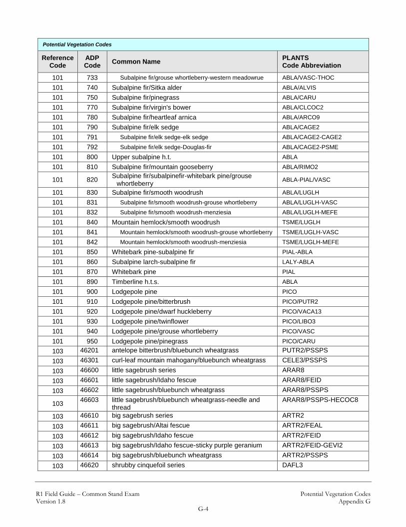
R1 Field Guide – Common Stand Exam Potential Vegetation Codes Version 1.8 Appendix G
G-1
Appendix G: Potential Vegetation Codes
Potential Vegetation Codes
Reference Code
ADP Code
Common Name PLANTS Code Abbreviation
101 010 Scree
101,111 000 Limber pine series PIFL2
101,111 040 Limber pine/bluebunch wheatgrass PIFL2/PSSPS
101,111 050 Limber pine/Idaho fescue PIFL2/FEID
101,111 051 Limber pine/Idaho fescue-Idaho fescue PIFL2/FEID-FEID
101,111 052 Limber pine/Idaho fescue-rough fescue PIFL2/FEID-FEAL
101,111 070 Limber pine/common juniper PIFL2/JUCO6
101 100 Ponderosa pine PIPO
101 110 Ponderosa pine/bluestem PIPO/ANDRO2
101 130 Ponderosa pine/bluebunch wheatgrass PIPO/PSSPS
101 140 Ponderosa pine/Idaho fescue PIPO/FEID
101 141 Ponderosa pine/Idaho fescue-Idaho fescue PIPO/FEID-FEID
101 142 Ponderosa pine/Idaho fescue-rough fescue PIPO/FEID-FEAL
101 160 Ponderosa pine/bitterbrush PIPO/PUTR2
101 161 Ponderosa pine/bitterbrush-bluebunch wheatgrass PIPO/PUTR2-PSSPS
101 162 Ponderosa pine/bitterbrush-Idaho fescue PIPO/PUTR2-FEID
101 170 Ponderosa pine/snowberry PIPO/SYAL
101 171 Ponderosa pine/snowberry-snowberry PIPO/SYAL-SYAL
101 172 Ponderosa pine/snowberry-creeping Oregon grape PIPO/SYAL-MARE11
101 180 Ponderosa pine/chokecherry PIPO/PRVI
101 181 Ponderosa pine/chokecherry-chokecherry PIPO/PRVI-PRVI
101 182 Ponderosa pine/chokecherry-buffaloberry PIPO/PRVI-SHCA
101 200 Douglas-fir PSME
101 210 Douglas-fir/bluebunch wheatgrass PSME/PSSPS
101 220 Douglas-fir/Idaho fescue PSME/FEID
101 230 Douglas-fir/rough fescue PSME/FEAL
101 250 Douglas-fir/dwarf huckleberry PSME/VACA13
101 260 Douglas-fir/ninebark PSME/PHMA5
101 261 Douglas-fir/ninebark-ninebark PSME/PHMA5-PHMA5
101 262 Douglas-fir/ninebark-pinegrass PSME/PHMA5-CARU
101 280 Douglas-fir/blue huckleberry PSME/VAME
101 281 Douglas-fir/blue huckleberry-blue huckleberry PSME/VAME-VAME
101 282 Douglas-fir/blue huckleberry-kinnikinnick PSME/VAME-ARUV
101 283 Douglas-fir/blue huckleberry-beargrass PSME/VAME-XETE
101 290 Douglas-fir/twinflower PSME/LIBO3

R1 Field Guide – Common Stand Exam Potential Vegetation Codes Version 1.8 Appendix G
G-2
Potential Vegetation Codes
Reference Code
ADP Code
Common Name PLANTS Code Abbreviation
101 291 Douglas-fir/twinflower-snowberry PSME/LIBO3-SYAL
101 292 Douglas-fir/twinflower-pinegrass PSME/LIBO3-CARU
101 293 Douglas-fir/twinflower-blue huckleberry PSME/LIBO3-VAME
101 310 Douglas-fir/snowberry PSME/SYAL
101 311 Douglas-fir/snowberry-bluebunch wheatgrass PSME/SYAL-PSSPS
101 312 Douglas-fir/snowberry-pinegrass PSME/SYAL-CARU
101 313 Douglas-fir/snowberry-snowberry PSME/SYAL-SYAL
101 320 Douglas-fir/pinegrass PSME/CARU
101 321 Douglas-fir/pinegrass-bluebunch wheatgrass PSME/CARU-PSSPS
101 322 Douglas-fir/pinegrass-kinnikinnick PSME/CARU-ARUV
101 323 Douglas-fir/pinegrass-pinegrass PSME/CARU-CARU
101 324 Douglas-fir/pinegrass-ponderosa pine PSME/CARU-PIPO
101 330 Douglas-fir/elk sedge PSME/CAGE2
101 340 Douglas-fir/white spirea PSME/SPBE2
101 350 Douglas-fir/kinnikinnick PSME/ARUV
101 360 Douglas-fir/common juniper PSME/JUCO6
101 365 Douglas-fir/bunchberry dogwood PSME/COCA13
101 370 Douglas-fir/heartleaf arnica PSME/ARCO9
101 380 Douglas-fir/mountain snowberry PSME/SYOR2
101 400 Spruce PICEA
101 410 Spruce/common horsetail PICEA/EQAR
101 420 Spruce/queencup beadlily PICEA/CLUN2
101 421 Spruce/queencup beadlily-dwarf huckleberry PICEA/CLUN2-VACA13
101 422 Spruce/queencup beadlily-queencup beadlily PICEA/CLUN2-CLUN2
101 430 Spruce/ninebark PICEA/PHMA5
101 440 Spruce/sweetscented bedstraw PICEA/GATR3
101 450 Spruce/dwarf huckleberry PICEA/VACA13
101 460 Spruce/cleft-leaf groundsel PICEA/PAST10
101 461 Spruce/cleft-leaf groundsel-Douglas-fir PICEA/PAST10-PSME
101 462 Spruce/cleft-leaf groundsel-spruce PICEA/PAST10-PICEA
101 470 Spruce/twinflower PICEA/LIBO3
101 480 Spruce/starry Solomon's seal PICEA/MAST4
101 500 Grand fir ABGR
101 501 Western redcedar THPL
101 502 Western hemlock TSHE
101 510 Grand fir/beargrass ABGR/XETE
101 520 Grand fir/queencup beadlily ABGR/CLUN2
101 521 Grand fir/queencup beadlily-queencup beadlilly ABGR/CLUN2-CLUN2
101 522 Grand fir/queencup beadlily-wild sarsaparilla ABGR/CLUN2-ARNU2
101 523 Grand fir/queencup beadlily-beargrass ABGR/CLUN2-XETE

R1 Field Guide – Common Stand Exam Potential Vegetation Codes Version 1.8 Appendix G
G-3
Potential Vegetation Codes
Reference Code
ADP Code
Common Name PLANTS Code Abbreviation
101 530 Western redcedar/queencup beadlily THPL/CLUN2
101 531 Western redcedar/queencup beadlily-queencup beadlily THPL/CLUN2-CLUN2
101 532 Western redcedar/queencup beadlily-wild sarsaparilla THPL/CLUN2-ARNU2
101 533 Western redcedar/queencup beadlily-menziesia THPL/CLUN2-MEFE
101 550 Western redcedar/devil's club THPL/OPHO
101 570 Western hemlock/queencup beadlily TSHE/CLUN2
101 571 Western hemlock/queencup beadlily-queencup beadlily TSHE/CLUN2-CLUN2
101 572 Western hemlock/queencup beadlily-wild sarsaparilla TSHE/CLUN2-ARNU2
101 590 Grand fir/twinflower ABGR/LIBO3
101 591 Grand fir/twinflower-twinflower ABGR/LIBO3-LIBO3
101 592 Grand fir/twinflower-beargrass ABGR/LIBO3-XETE
101 600 Subalpine fir ABLA
101 610 Subalpine fir/devil's club ABLA/OPHO
101 620 Subalpine fir/queencup beadlily ABLA/CLUN2
101 621 Subalpine fir/queencup beadlily-queencup beadlily ABLA/CLUN2-CLUN2
101 622 Subalpine fir/queencup beadlily-wild sarsaparilla ABLA/CLUN2-ARNU2
101 623 Subalpine fir/queencup beadlily-dwarf huckleberry ABLA/CLUN2-VACA13
101 624 Subalpine fir/queencup beadlily-beargrass ABLA/CLUN2-XETE
101 625 Subalpine fir/queencup beadlily-menziesia ABLA/CLUN2-MEFE
101 630 Subalpine fir/sweetscented bedstraw ABLA/GATR3
101 640 Subalpine fir/dwarf huckleberry ABLA/VACA13
101 650 Subalpine fir/bluejoint ABLA/CACA4
101 651 Subalpine fir/bluejoint-bluejoint ABLA/CACA4-CACA4
101 653 Subalpine fir/bluejoint-sweetscented bedstraw ABLA/CACA4-GATR3
101 654 Subalpine fir/bluejoint-dwarf huckleberry ABLA/CACA4-VACA13
101 660 Subalpine fir/twinflower ABLA/LIBO3
101 661 Subalpine fir/twinflower-twinflower ABLA/LIBO3-LIBO3
101 662 Subalpine fir/twinflower-beargrass ABLA/LIBO3-XETE
101 663 Subalpine fir/twinflower-grouse whortleberry ABLA/LIBO3-VASC
101 670 Subalpine fir/menziesia ABLA/MEFE
101 680 Mountain hemlock/menziesia TSME/MEFE
101 690 Subalpine fir/beargrass ALBA/XETE
101 691 Subalpine fir/beargrass-blue huckleberry ALBA/XETE-VAME
101 692 Subalpine fir/beargrass-grouse whortleberry ALBA/XETE-VASC
101 700 Mountain hemlock ABLA
101 710 Mountain hemlock/beargrass TSME/XETE
101 720 Subalpine fir/blue huckleberry ABLA/VAME
101 730 Subalpine fir/grouse whortleberry ABLA/VASC
101 731 Subalpine fir/grouse whortleberry-pinegrass ABLA/VASC-CARU
101 732 Subalpine fir/grouse whortleberry-grouse whortleberry ABLA/VASC-VASC
R1 Field Guide – Common Stand Exam Potential Vegetation Codes Version 1.8 Appendix G
G-4
Potential Vegetation Codes
Reference Code
ADP Code
Common Name PLANTS Code Abbreviation
101 733 Subalpine fir/grouse whortleberry-western meadowrue ABLA/VASC-THOC
101 740 Subalpine fir/Sitka alder ABLA/ALVIS
101 750 Subalpine fir/pinegrass ABLA/CARU
101 770 Subalpine fir/virgin's bower ABLA/CLCOC2
101 780 Subalpine fir/heartleaf arnica ABLA/ARCO9
101 790 Subalpine fir/elk sedge ABLA/CAGE2
101 791 Subalpine fir/elk sedge-elk sedge ABLA/CAGE2-CAGE2
101 792 Subalpine fir/elk sedge-Douglas-fir ABLA/CAGE2-PSME
101 800 Upper subalpine h.t. ABLA
101 810 Subalpine fir/mountain gooseberry ABLA/RIMO2
101 820 Subalpine fir/subalpinefir-whitebark pine/grouse
whortleberry ABLA-PIAL/VASC
101 830 Subalpine fir/smooth woodrush ABLA/LUGLH
101 831 Subalpine fir/smooth woodrush-grouse whortleberry ABLA/LUGLH-VASC
101 832 Subalpine fir/smooth woodrush-menziesia ABLA/LUGLH-MEFE
101 840 Mountain hemlock/smooth woodrush TSME/LUGLH
101 841 Mountain hemlock/smooth woodrush-grouse whortleberry TSME/LUGLH-VASC
101 842 Mountain hemlock/smooth woodrush-menziesia TSME/LUGLH-MEFE
101 850 Whitebark pine-subalpine fir PIAL-ABLA
101 860 Subalpine larch-subalpine fir LALY-ABLA
101 870 Whitebark pine PIAL
101 890 Timberline h.t.s. ABLA
101 900 Lodgepole pine PICO
101 910 Lodgepole pine/bitterbrush PICO/PUTR2
101 920 Lodgepole pine/dwarf huckleberry PICO/VACA13
101 930 Lodgepole pine/twinflower PICO/LIBO3
101 940 Lodgepole pine/grouse whortleberry PICO/VASC
101 950 Lodgepole pine/pinegrass PICO/CARU
103 46201 antelope bitterbrush/bluebunch wheatgrass PUTR2/PSSPS
103 46301 curl-leaf mountain mahogany/bluebunch wheatgrass CELE3/PSSPS
103 46600 little sagebrush series ARAR8
103 46601 little sagebrush/Idaho fescue ARAR8/FEID
103 46602 little sagebrush/bluebunch wheatgrass ARAR8/PSSPS
103 46603 little sagebrush/bluebunch wheatgrass-needle and
thread ARAR8/PSSPS-HECOC8
103 46610 big sagebrush series ARTR2
103 46611 big sagebrush/Altai fescue ARTR2/FEAL
103 46612 big sagebrush/Idaho fescue ARTR2/FEID
103 46613 big sagebrush/Idaho fescue-sticky purple geranium ARTR2/FEID-GEVI2
103 46614 big sagebrush/bluebunch wheatgrass ARTR2/PSSPS
103 46620 shrubby cinquefoil series DAFL3

R1 Field Guide – Common Stand Exam Potential Vegetation Codes Version 1.8 Appendix G
G-5
Potential Vegetation Codes
Reference Code
ADP Code
Common Name PLANTS Code Abbreviation
103 46621 shrubby cinquefoil/Altai fescue DAFL3/FEAL
103 46622 shrubby cinquefoil/Altai fescue-timber oatgrass DAFL3/FEAL-DAIN
103 46623 shrubby cinquefoil/Idaho fescue DAFL3/FEID
103 46630 antelope bitterbrush series PUTR2
103 46632 antelope bitterbrush/Idaho fescue PUTR2/FEID
103 46633 antelope bitterbrush/Altai fescue PUTR2/FEAL
103 46640 skunkbush sumac series RHTR
103 46641 skunkbush sumac/Idaho fescue RHTR/FEID
103 46642 skunkbush sumac/bluebunch wheatgrass RHTR/PSSPS
103 46650 greasewood series SAVE4
103 46651 greasewood/basin wildrye SAVE4/LECI4
103 46652 greasewood/western wheatgrass SAVE4/PASM
103 47003 Idaho fescue-western wheatgrass- streambank
wheatgrass FEID-PASM-ELLAL
103 47004 Idaho fescue/bearded wheatgrass FEID/ELCA11
103 47100 tufted hairgrass series DECA18
103 47101 tufted hairgrass/sedge DECA18/CAREX
103 47110 Altai fescue series FEAL
103 47111 Altai fescue/Idaho fescue FEAL/FEID
103 47112 Altai fescue/Idaho fescue-Richardson's needlegrass FEAL/FEID-ACRI8
103 47113 Altai fescue/Idaho fescue-sticky purple geranium FEAL/FEID-GEVI2
103 47114 Altai fescue/bluebunch wheatgrass FEAL/PSSPS
103 47115 Altai fescue/bluebunch wheatgrass-needle and thread FEAL/PSSPS-HECOC8
103 47120 Idaho fescue series FEID
103 47121 Idaho fescue/Richardson's needlegrass FEID/ACRI8
103 47122 Idaho fescue/threadleaf sedge FEID/CAFI
103 47123 Idaho fescue/tufted hairgrass FEID/DECA18
103 47124 Idaho fescue/bearded wheatgrass-sticky purple
geranium FEID/ELCA11-GEVI2
103 47125 Idaho fescue/western wheatgrass FEID/PASM
103 47126 Idaho fescue/bluebunch wheatgrass FEID/PSSPS
103 47127 Idaho fescue/bluebunch wheatgrass-western
needlegrass FEID/PSSPS-ACOCO
103 47130 needle and thread series HECOC8
103 47131 needle and thread/blue grama HECOC8/BOGR2
103 47132 needle and thread/blue grama-western wheatgrass HECOC8/BOGR2-PASM
103 47140 bluebunch wheatgrass series PSSPS
103 47141 bluebunch wheatgrass/blue grama PSSPS/BOGR2
103 47142 bluebunch wheatgrass/blue grama-dotted blazing star PSSPS/BOGR2-LIPU
103 47143 bluebunch wheatgrass/western wheatgrass PSSPS/PASM
103 47144 bluebunch wheatgrass/western wheatgrass-green
needlegrass PSSPS/PASM-NAVI4

R1 Field Guide – Common Stand Exam Potential Vegetation Codes Version 1.8 Appendix G
G-6
Potential Vegetation Codes
Reference Code
ADP Code
Common Name PLANTS Code Abbreviation
110 100 Ponderosa pine PIPO
110 130 Ponderosa pine/bluebunch wheatgrass PIPO/PSSPS
110 140 Ponderosa pine/Idaho fescue PIPO/FEID
110 170 Ponderosa pine/ninebark PIPO/SYAL
110 190 Ponderosa pine/ninebark PIPO/PHMA5
110 200 Douglas fir series PSME
110 210 Douglas-fir/bluebunch wheatgrass PSME/PSSPS
110 220 Douglas-fir/Idaho fescue PSME/FEID
110 250 Douglas-fir/dwarf huckleberry PSME/VACA13
110 260 Douglas-fir/ninebark PSME/PHMA5
110 261 Douglas-fir/ninebark-ninebark PSME/PHMA5-PHMA5
110 263 Douglas-fir/ninebark-starry Solomon's seal PSME/PHMA5/MAST4
110 280 Douglas-fir/blue huckleberry PSME/VAME
110 310 Douglas-fir/common snowberry PSME/SYAL
110 320 Douglas-fir/pinegrass PSME/CARU
110 322 Douglas-fir/pinegrass-kinnikinnick PSME/CARU-ARUV
110 323 Douglas-fir/pinegrass-pinegrass PSME/CARU-CARU
110 330 Douglas-fir/elk sedge PSME/CAGE2
110 340 Douglas-fir/white spirea PSME/SPBE2
110 500 Grand fir ABGR
110 501 Western redcedar series THPL
110 502 Western hemlock series TSHE
110 505 Grand fir/white spirea ABGR/SPBE2
110 506 Grand fir/ninebark ABGR/PHMA5
110 507 Grand fir/ninebark-western gold thread ABGR/PHMA5/COOC
110 508 Grand fir/ninebark-ninebark ABGR/PHMA5-PHMA5
110 510 Grand fir/beargrass ABGR/XETE
110 511 Grand fir/beargrass-western gold thread ABGR/XETE/COOC
110 512 Grand fir/beargrass-blue huckleberry ABGR/XETE-VAME
110 515 Grand fir/blue huckleberry ABGR/VAME
110 516 Grand fir/wild ginger ABGR/ASCA2
110 517 Grand fir/wild ginger-wild ginger ABGR/ASCA2-ASCA2
110 518 Grand fir/wild ginger-menziesia ABGR/ASCA2-MEFE
110 519 Grand fir/wild ginger-Pacific yew ABGR/ASCA2-TABR2
110 520 Grand fir/queencup beadlily ABGR/CLUN2
110 521 Grand fir/queencup beadlily-queencup beadlily ABGR/CLUN2-CLUN2
110 523 Grand fir/queencup beadlily-beargrass ABGR/CLUN2-XETE
110 524 Grand fir/queencup beadlily-ninebark ABGR/CLUN2-PHMA5
110 525 Grand fir/queencup beadlily-menziesia ABGR/CLUN2-MEFE
110 526 Grand fir/queencup beadlily-Pacific yew ABGR/CLUN2-TABR2

R1 Field Guide – Common Stand Exam Potential Vegetation Codes Version 1.8 Appendix G
G-7
Potential Vegetation Codes
Reference Code
ADP Code
Common Name PLANTS Code Abbreviation
110 529 Grand fir/queencup beadlily-arrowleaf groundsel ABGR/SETR
110 530 Western redcedar/queencup beadlily THPL/CLUN2
110 531 Western redcedar/queencup beadlily-queencup beadlily THPL/CLUN2-CLUN2
110 533 Western redcedar/queencup beadlily-menziesia THPL/CLUN2-MEFE
110 534 Western redcedar/queencup beadlily-beargrass THPL/CLUN2-XETE
110 535 Western redcedar/queencup beadlily-Pacific yew THPL/CLUN2-TABR2
110 540 Western redcedar/lady fern THPL/ATFI
110 541 Western redcedar/lady fern-maidenhair fern THPL/ATFI-ADPE
110 542 Western redcedar/lady fern-lady fern THPL/ATFI-ATFI
110 545 Western redcedar/wild ginger THPL/ASCA2
110 546 Western redcedar/wild ginger-wild ginger THPL/ASCA2-ASCA2
110 547 Western redcedar/wild ginger-menziesia THPL/ASCA2-MEFE
110 548 Western redcedar/wild ginger-Pacific yew THPL/ASCA2-TABR2
110 550 Western redcedar/devil's club THPL/OPHO
110 555 Western redcedar/oak fern THPL/GYDR
110 560 Western redcedar/maidenhair fern THPL/ADPE
110 565 Western hemlock/oak fern TSHE/GYDR
110 570 Western hemlock/queencup beadlily TSHE/CLUN2
110 571 Western hemlock/queencup beadlily-queencup beadlily TSHE/CLUN2-CLUN2
110 572 Western hemlock/queencup beadlily-wild sarsaparilla TSHE/CLUN2-ARNU2
110 573 Western hemlock/queencup beadlily-mefe TSHE/CLUN2-MEFE
110 574 Western hemlock/queencup beadlily-beargrass TSHE/CLUN2-XETE
110 575 Western hemlock/wild ginger TSHE/ASCA2
110 576 Western hemlock/wild ginger-wild sarsaparilla TSHE/ASCA2-ARNU2
110 577 Western hemlock/wild ginger-menziesia TSHE/ASCA2-MEFE
110 578 Western hemlock/wild ginger-wild ginger TSHE/ASCA2-ASCA2
110 579 Western hemlock/menziesia TSHE/MEFE
110 590 Grand fir/twinflower ABGR/LIBO3
110 591 Grand fir/twinflower-twinflower ABGR/LIBO3-LIBO3
110 592 Grand fir/twinflower-beargrass ABGR/LIBO3-XETE
110 600 Subalpine fir series ABLA
110 620 Subalpine fir/queencup beadlily ABLA/CLUN2
110 621 Subalpine fir/queencup beadlily-queencup beadlily ABLA/CLUN2-CLUN2
110 624 Subalpine fir/queencup beadlily-beargrass ABLA/CLUN2-XETE
110 625 Subalpine fir/queencup beadlily-menziesia ABLA/CLUN2-MEFE
110 635 Subalpine fir/twisted stalk ABLA/STAM2
110 636 Subalpine fir/twisted stalk-menziesia ABLA/STAM2-MEFE
110 637 Subalpine fir/twisted stalk-Canby's ligusticum ABLA/STAM2-LICA2
110 640 Subalpine fir/dwarf huckleberry ABLA/VACA13
110 650 Subalpine fir/bluejoint ABLA/CACA4

R1 Field Guide – Common Stand Exam Potential Vegetation Codes Version 1.8 Appendix G
G-8
Potential Vegetation Codes
Reference Code
ADP Code
Common Name PLANTS Code Abbreviation
110 651 Subalpine fir/bluejoint-bluejoint ABLA/CACA4-CACA4
110 652 Subalpine fir/bluejoint-Canby's ligusticum ABLA/CACA4-LICA2
110 654 Subalpine fir/bluejoint-dwarf huckleberry ABLA/CACA4-VACA13
110 655 Subalpine fir/bluejoint-Labrador tea ABLA/CACA4-LEGL
110 670 Subalpine fir/menziesia ABLA/MEFE
110 671 Subalpine fir/menziesia-western gold thread ABLA/MEFE-COOC
110 672 Subalpine fir/menziesia-smooth woodrush ABLA/MEFE-LUGLH
110 673 Subalpine fir/menziesia-beargrass ABLA/MEFE-XETE
110 674 Subalpine fir/menziesia-grouse whortleberry ABLA/MEFE-VASC
110 675 Mountain hemlock/twisted stalk TSME/STAM2
110 676 Mountain hemlock/twisted stalk-smooth woodrush TSME/STAM2-LUGLH
110 677 Mountain hemlock/twisted stalk-menziesia TSME/STAM2-MEFE
110 680 Mountain hemlock/menziesia TSME/MEFE
110 681 Mountain hemlock/menziesia-smooth woodrush TSME/MEFE-LUGLH
110 682 Mountain hemlock/menziesia-beargrass TSME/MEFE-XETE
110 685 Mountain hemlock/queencup beadlily TSME/CLUN2
110 686 Mountain hemlock/queencup beadlily-menziesia TSME/CLUN2-MEFE
110 687 Mountain hemlock/queencup beadlily-beargrass TSME/CLUN2-XETE
110 690 Subalpine fir/beargrass ABLA/XETE
110 691 Subalpine fir/beargrass-blue huckleberry ABLA/XETE-VAME
110 692 Subalpine fir/beargrass-grouse whortleberry ABLA/XETE-VASC
110 693 Subalpine fir/beargrass-western gold thread ABLA/XETE-COOC
110 694 Subalpine fir/beargrass-smooth woodrush ABLA/XETE-LUGLH
110 700 Mountain hemlock TSME series
110 710 Mountain hemlock/beargrass TSME/XETE
110 711 Mountain hemlock/beargrass-smooth woodrush TSME/XETE-LUGLH
110 712 Mountain hemlock/beargrass-blue huckleberry TSME/XETE-VAME
110 713 Mountain hemlock/beargrass-grouse whortleberry TSME/XETE-VASC
110 720 Subalpine fir/blue huckleberry ABLA/VAME
110 730 Subalpine fir/grouse whortleberry ABLA/VASC
110 750 Subalpine fir/pinegrass ABLA/CARU
110 830 Subalpine fir/smooth woodrush ABLA/LUGLH
110 840 Mountain hemlock/smooth woodrush TSME/LUGLH
110 850 Whitebark pie-subalpine fir PIAL-ABLA
110 860 Subalpine larch-subalpine fir LALY-ABLA
110 900 Lodgepole pine series PICO
110 920 Lodgepole pine/dwarf huckleberry PICO/VACA13
110 925 Beargrass PICO/XETE
110 940 Lodgepole pine/grouse whortleberry PICO/VASC
112 4 Engelmann spruce/field horsetail PIEN/EQAR

R1 Field Guide – Common Stand Exam Potential Vegetation Codes Version 1.8 Appendix G
G-9
Potential Vegetation Codes
Reference Code
ADP Code
Common Name PLANTS Code Abbreviation
112 6 spruce/bluejoint PICEA/CACA4
112 12 spruce/fragrant bedstraw PICEA/GATR3
112 30 Sitka alder communities ALVIS
112 43 Engelmann spruce/redosier dogwood PIEN/COSEO
112 44 Engelmann spruce/American skunkcabbage PIEN/LYAM3
112 103 narrowleaf cotonwood/recent alluvial barr POAN3
112 104 narrowleaf cotonwood/herbaceous POAN3
112 105 narrowleaf cottonleaf/western snowberry POAN3/SYOC
112 106 narrowleaf cottonleaf/western snowberry POAN3/COSES
112 110 green ash/chokecherry FRPE/PRVI
112 111 boxelder/chokecherry ACNE2/PRVI
112 112 Russian olive ELAN
112 113 plains cottonwood/redosier deogwood PODEM/COSES
112 114 plains cottonwood/herbaceous PODEM
112 115 plains cottonwood/recent alluvial bar PODEM
112 116 plains cottonwood/western snowberry PODEM/SYOC
112 117 quaking aspen/creeping barberry POTR5/MARE11
112 118 quakingaspen/bluejoint POTR5/CACA4
112 119 quaking aspen/redoiser dogwood POTR5/COSES
112 120 quaking aspen/western sweetroot POTR5/OSOC
112 121 quaking aspen/Kentucky bluegrass POTR5/POPR
112 122 black cottonwood/redosier dogwood POBAT/COSES
112 123 black cottonwood/herbaceous POBAT
112 124 black cottonwood/recent alluvial bar POBAT
112 125 Black cottonwood/western snowberry POBAT/SYOR
112 130 peachleaf willow SAAM2
112 131 Bebb willow SABE2
112 132 sageleaf willow/beaked sedge SACA4/CARO6
112 133 Drummond's willow/bluejoint SADR/CACA4
112 134 Drummond's willow/beaked sedge SADR/CARO6
112 135 Drummond's willow SADR
112 136 Geyer willow/bluejoint SAGE2/CACA4
112 137 Geyer willow/beaked sedge SAGE2/CARO6
112 138 Geyer willow SAGE2
112 139 Pacific willow SALUL
112 140 yellow willow/bluejoint SALU2/CACA4
112 141 yellow willow/beaked sedge SALU2/CARO6
112 142 yellow willow SALU2
112 143 diamondleaf willow/water sedge SAPL2/CAAQ
112 144 Wolf's willow/water sedge SAWO/CAAQ

R1 Field Guide – Common Stand Exam Potential Vegetation Codes Version 1.8 Appendix G
G-10
Potential Vegetation Codes
Reference Code
ADP Code
Common Name PLANTS Code Abbreviation
112 145 Wolf/s willow/tufted hairgrass SAWO/DECA18
112 146 gray alder ALIN2
112 150 silver sagebrush/western wheatgrass ARCA13/PASM
112 151 silver sagebrush/Idaho fescue ARCA13/FEID
112 152 resin birch/beaked sedge BEGL/CARO6
112 153 water birch BEOC2
112 154 fleshy hawthorn CRSU5
112 155 alpine laurel/mountain sedge KAMI/CASC12
112 156 chockcherry PRVI
112 157 Woods' rose ROWO
112 158 greasewood/westerm wheatgrass SAVE4/PASM
112 159 silver buffaloberry SHAR
112 160 rose spirea SPDO
112 161 western snowberry SYOC
112 162 five-stamen tamarisk TACH2
112 180 ponderosa pine/chokecherry PIPO/PRVI
112 181 ponderosa pine/redosier dogwood PIPO/COSES
112 200 water sedge/water sedge CAAQ/CAAQ
112 201 water sedge/tufted hairgrass CAAQ/DECA18
112 202 mud sedge CALI7
112 203 beaked sedge/water sedge CARO6/CAAQ
112 204 beaked sedge/beaked sedge CARO6/CARO6
112 205 beaked sedge/tufted hairgrass CARO6/DECA18
112 210 westerm wheatgrass PASM
112 211 creeping bentgrass AGST2
112 212 smooth brome BRIN2
112 213 bluejoint CACA4
112 214 saltgrass DISP
112 215 water horsetail EQFL
112 216 small floating mannagrass GLBO
112 217 American licorice GLLE3
112 218 foxtail barley HOJU
112 219 reed canarygrass PHAR3
112 219 reed canarygrass PHAR3
112 220 common reed PHAU7
112 221 fowl bluegrass POPA2
112 222 water knotweed POAM8
112 223 red swampfire SARU
112 224 hardstem bulrush SCAC3
112 225 cosmopolitan bulrush SCMA8

R1 Field Guide – Common Stand Exam Potential Vegetation Codes Version 1.8 Appendix G
G-11
Potential Vegetation Codes
Reference Code
ADP Code
Common Name PLANTS Code Abbreviation
112 226 chairmaker's bulrush SCAM6
112 227 arrowleaf ragwort SETR
112 228 prairie cordgrass SPPE
112 400 Rocky Mountain juniper/redosier dogwood JUSC2/COSES
112 540 western red cedar/common ladyfern THPL/ATFI
112 542 western red cedar/common ladyfern-common ladyfern THPL/ATFI-ATFI
112 550 western red cedar/devilsclub THPL/OPHO
112 555 western red cedar/western oakfern THPL/GYDR
112 565 western hemlock/western oakfern TSHE/GYDR
112 601 subalpine fir/red baneberry ABLA/ACRU2
112 610 subalpine fir/devilsclub ABLA/OPHO
112 613 grand fir/common ladyfern ABGR/ATFI
112 630 subalpine fir/fragrant bedstraw ABLA/GATR3
112 631 subalpine fir/western labrador tea ABLA/LEGL
112 632 subalpine fir/western labrador tea-bluejoint ABLA/LEGL-CACA4
112 633 subalpine fir/western labrador tea-western labrador tea ABLA/LEGL-LEGL
112 635 subalpine fir/claspleaf twistedstalk ABLA/STAM2
112 636 subalpine fir/claspleaf twistedstalk- claspleaf twistedstalk
ABLA/STAM2-STAM2
112 637 subalpine fir/claspleaf twistedstalk-rusty menziesia ABLA/STAM2-MEFE
112 650 subalpine fir/bluejoint ABLA/CACA4
112 651 subalpine fir/bluejoint-bluejoint ABLA/CACA4-CACA4
112 652 subalpine fir/bluejoint-Canby’s licorice-root ABLA/CACA4-LICA2
112 654 subalpine fir/bluejoint-dwarf bilberry ABLA/CACA4-VACA13
112 700 Dougals-fir/redosier dogwood PSME/COSES
112 HCS113 black cottonwood/thinleaf alder-redosier dogwood POBAT/ALINT-COSES
112 MD3111 Kentucky bluegrass (dry meadow) POPR
112 MM1912 tufted hairgrass (moist meadow) DECA18
112 MM2911 woolly sedge (moist meadow) CAPE42
112 MM2912 Nebraska sedge (moist meadow) CANE2
112 MM2914 water sedge (aquatic moist meadow) CAAQ
112 MM2915 analogue sedge (moist meadow) CASI2
112 MM2917 Northwest Territory sedge (moist meadow) CAUT
112 MM2920 woollyfruit sedge (moist meadow) CALA11
112 MS3111 mountain sedge (subalpine wet meadow) CASC12
112 MW3912 Baltic rush JUBA
112 MW4911 fewflower spikerush ELQU2
112 MW4912 common spikerush ELPA3
112 SW1117 narrowleaf willow SAEX
112 SW3111 black hawthorn CRDO2

R1 Field Guide – Common Stand Exam Potential Vegetation Codes Version 1.8 Appendix G
G-12
Potential Vegetation Codes
Reference Code
ADP Code
Common Name PLANTS Code Abbreviation
112 SW5112 redosier dogwood COSES
112 SW5113 shrubby cinquefoil/tufted hairgrass DAFL3/DECA18
113 1 Idaho fescue/varileaf cinquefoil FEID/PODI2
113 2 tufted hairgrass/varileaf cinquefoil DECA18/PODI2
113 3 spike fescue/field locoweed LEKI2/OXCA4
113 4 blackroot sedge CAEL3
113 5 northern singlespike sedge/varileaf cinquefoil CASC10/PODI2
113 6 northern singlespike sedge/Ross’s avens CASC10/GERO2
113 7 eightpetal mountain-avens/alpine bistort DROC/POVI3
113 8 arctic willow/American bistort SAAR27/POBI6
113 9 curly sedge/sheep cinquefoil CARU3/POOV2
113 10 Ross’s avens/twinflower sandwort GERO2/MIOB2
113 11 eightpetal mountain-avens/curly sedge DROC/CARU3
113 12 black alpine sedge CANI2
113 13 Drummond’s rush/woolly pussytoes JUDR/ANLA3
113 14 pink mountainheath/woolly pussytoes PHEM/ANLA3
113 15 western moss heather/Payson’s sedge CAME7/CAPA31
113 16 Parry’s rush/Bear River fleabane JUPA/ERUR2
113 17 grayleaf willow SAGL
113 18 tufted hairgrass/white marsh marigold DECA18/CALE4
113 19 mountain sedge/white marsh marigold CASC12/CALE4
113 20 netleaf willow/white marsh marigold SARE2/CALE4
113 21 diamondleaf willow/mountain sedge SAPL2/CASC12
113 22 Dry slope communities
113 23 Moist slope communities
113 24 spike fescue LEKI2
113 25 Ross' avens, Parry's clover GERO2/TRPA5
113 26 flowery phlox/dwarf clover PHMU3/TRNA2
113 27 cushion phlox/alpine clover PHPU5/TRDA2
113 28 alpine clover/Ross' avens TRDA2/GERO2
113 29 littleleaf pussytoes/alpine sagebrush ANMI3/ARSC
115 100 western wheatgrass/green needlegrass PASM/NAV14
115 1000 Silver sagebrush/western wheatgrass ARCA13/PASM
115 1100 Wyoming big sagebrush/western wheatgrass ARTRW8/PASM
115 1200 Wyoming big sagebrush/bluebunch wheatgrass ARTRW8/PSSPS 115 1300 Shadescale saltbrush/Wyoming big sagebrush ATCO/SRTRW8
115 1400 creeping juniper/little bluestem JUHO2/SCSCS
115 1500 shrubby cinquefoil/little bluestem DAFR6/SCSCS
115 1600 fragrant sumac/bluebunch wheatgrass RHAR4/PSSPS
115 1700 fragrant sumac/plains muhley RHAR4/MUCU3

R1 Field Guide – Common Stand Exam Potential Vegetation Codes Version 1.8 Appendix G
G-13
Potential Vegetation Codes
Reference Code
ADP Code
Common Name PLANTS Code Abbreviation
115 1800 greasewood/western wheatgrass SAVE4/PASM
115 1900 greasewood/bluebunch wheatgrass SAVE4/PSSPS
115 200 little bluestem/threadleaf sedge SCSCS/CAFI
115 2000 silver buffaloberry SHAR
115 2100 western snowberry SYOC
115 300 big bluestem ANGE
115 400 western wheatgrass/needle and thread PASM/HECOC8
115 500 prairie sandreed/carex CALO/CAREX
115 600 saltgrass DISP
115 700 Nuttall’s alkaligrass/saltgrass PUNU2/DISP
115 800 needle and thread/threadleaf sedge HECOC8/CAFI
115 900 little sagebrush/bluegramma ARAR8/BOGR2
116 10 American basswood/bur oak TIAM/QUMA2
116 20 quaking aspen/western poinson ivy POTR5/TORY
116 30 sand bluestem/little bluestem ANHA/BOCU
116 40 big bluestem/little bluestem ANGE/SCSC (ANGE/ANSC10)
116 50 wolly sedge/slimstem reedgrass CALA30/CAST36
116 60 Hummock types BOGR2 or POPR
199 090 Limber pine series PIFL2
199 091 Limber pine/bluebunch wheatgrass PIFL2/PSSPS
199 092 Limber pine/Idaho fescue PIFL2/FEID
199 093 Limber pine/Idaho fescue-Idaho fescue PIFL2/FEID-FEID
199 094 Limber pine/Idaho fescue-rough fescue PIFL2/FEID-FEAL
199 095 Limber pine/common juniper PIFL/JUCO6

R1 Field Guide – Common Stand Exam List of Species Version 1.8 Appendix H
H-1
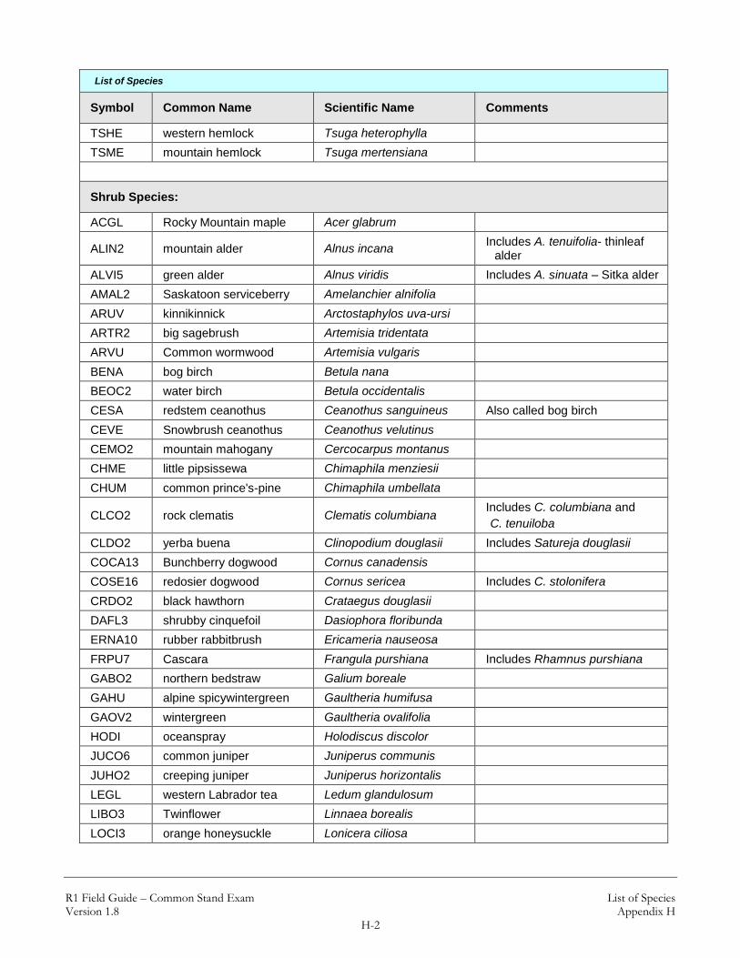
Appendix H: List of Species
List of Species
Symbol Common Name Scientific Name Comments
Tree Species (temporary symbol):
2TD Tree, deciduous
To be used temporarily until local Botanist identifies species.
Not to be loaded into FSVeg.
2TE Tree, evergreen
To be used temporarily until local Botanist identifies species.
Not to be loaded into FSVeg.
Tree Species:
ABGR grand fir Abies grandis
ABLA subalpine fir Abies lasiocarpa
ALRU2 red alder Alnus rubra
BEOC2 water birch Betula occidentalis
BEPA paper birch Betula papyrifera
CELE3 Curl-leaf mountain
mahogany Cercocarpus ledifolius
FRPE green ash Fraxinus pennsylvanica
JUOS Utah juniper Juniperus osteosperma
JUSC2 Rocky Mountain juniper Juniperus scopulorum
LALY subalpine larch Larix lyallii
LAOC western larch Larix occidentalis
PIAL whitebark pine Pinus albicaulis
PICO lodgepole pine Pinus contorta
PIEN Engelmann spruce Picea engelmannii
PIFL2 limber pine Pinus flexilis
PIGL white spruce Picea glauca
PIMO3 western white pine Pinus monticola
PIPO ponderosa pine Pinus ponderosa
POBA2 Balsam poplar Populus balsamifera Includes P. trichocarpa – black
cottonwood
POTR5 quaking aspen Populus tremuloides
PSME Douglas-fir Pseudotsuga menziesii
TABR2 Pacific yew Taxus brevifolia
THPL western redcedar Thuja plicata
R1 Field Guide – Common Stand Exam List of Species Version 1.8 Appendix H
H-2
List of Species
Symbol Common Name Scientific Name Comments
TSHE western hemlock Tsuga heterophylla
TSME mountain hemlock Tsuga mertensiana
Shrub Species:
ACGL Rocky Mountain maple Acer glabrum
ALIN2 mountain alder Alnus incana Includes A. tenuifolia- thinleaf
alder
ALVI5 green alder Alnus viridis Includes A. sinuata – Sitka alder
AMAL2 Saskatoon serviceberry Amelanchier alnifolia
ARUV kinnikinnick Arctostaphylos uva-ursi
ARTR2 big sagebrush Artemisia tridentata
ARVU Common wormwood Artemisia vulgaris
BENA bog birch Betula nana
BEOC2 water birch Betula occidentalis
CESA redstem ceanothus Ceanothus sanguineus Also called bog birch
CEVE Snowbrush ceanothus Ceanothus velutinus
CEMO2 mountain mahogany Cercocarpus montanus
CHME little pipsissewa Chimaphila menziesii
CHUM common prince's-pine Chimaphila umbellata
CLCO2 rock clematis Clematis columbiana Includes C. columbiana and
C. tenuiloba
CLDO2 yerba buena Clinopodium douglasii Includes Satureja douglasii
COCA13 Bunchberry dogwood Cornus canadensis
COSE16 redosier dogwood Cornus sericea Includes C. stolonifera
CRDO2 black hawthorn Crataegus douglasii
DAFL3 shrubby cinquefoil Dasiophora floribunda
ERNA10 rubber rabbitbrush Ericameria nauseosa
FRPU7 Cascara Frangula purshiana Includes Rhamnus purshiana
GABO2 northern bedstraw Galium boreale
GAHU alpine spicywintergreen Gaultheria humifusa
GAOV2 wintergreen Gaultheria ovalifolia
HODI oceanspray Holodiscus discolor
JUCO6 common juniper Juniperus communis
JUHO2 creeping juniper Juniperus horizontalis
LEGL western Labrador tea Ledum glandulosum
LIBO3 Twinflower Linnaea borealis
LOCI3 orange honeysuckle Lonicera ciliosa

R1 Field Guide – Common Stand Exam List of Species Version 1.8 Appendix H
H-3
List of Species
Symbol Common Name Scientific Name Comments
LOIN5 twinberry honeysuckle Lonicera involucrata
LOUT2 Utah honeysuckle Lonicera utahensis
MAAQ2 tall Oregon grape Mahonia aquifolium Includes Berberis aquifolium
MARE11 creeping barberry Mahonia repens Includes Berberis repens
MEFE rusty menziesia Menziesia ferruginea
OPHO Devilsclub Oplopanax horridum
PAMY Oregon boxleaf Paxistima myrsinites = Pachistima myrsinites
PHLE4 mockorange; syringa Philadelphus lewisii
PHEM pink mountainheath Phyllodoce empetriformis
PHMA5 mallow ninebark Physocarpus malvaceus
PREM bittercherry Prunus emarginata
PRVI chokecherry Prunus virginiana
PUTR2 antelope bitterbrush Purshia tridentata
RHAL alder buckthorn Rhamnus alnifolia
RHAL2 Cascade azalea Rhododendron albiflorum
RHTR skunkbush sumac Rhus trilobata
RICE squaw currant Ribes cereum
RIHU stinking currant Ribes hudsonianum
RILA prickly currant Ribes lacustre
RIMO2 gooseberry currant Ribes montigenum
RIVI3 sticky currant Ribes viscosissimum
ROAC prickly rose Rosa acicularis
ROGY dwarf rose Rosa gymnocarpa
RONU nootka rose Rosa nutkana
ROWO Woods' rose Rosa woodsii
RUID red raspberry Rubus idaeus
RUNI2 snow dewberry Rubus nivalis
RUPA thimbleberry Rubus parviflorus
RUUR blackberry Rubus ursinus
SALIX Willow Salix spp.
SASC Scouler's willow Salix scouleriana
SANI4 European black elderberry Sambucus nigra Includes S. cerulea
SARA2 elderberry Sambucus racemosa
SHCA russet buffaloberry Shepherdia canadensis
SOSC2 Greene mountain-ash Sorbus scopulina
SOSI2 Sitka mountain-ash Sorbus sitchensis
SPBE2 white spirea Spiraea betulifolia
SYAL common snowberry Symphoricarpos albus

R1 Field Guide – Common Stand Exam List of Species Version 1.8 Appendix H
H-4
List of Species
Symbol Common Name Scientific Name Comments
SYHE creeping snowberry Symphoricarpos hesperius
VAME thinleaf huckleberry Vaccinium
membranaceum Includes V. globulare
VACA13 dwarf huckleberry Vaccinium caespitosum Includes V. cespitosum
VAMY Velvetleaf blueberry Vaccinium myrtilloides
VAMY2 whortleberry Vaccinium myrtillus
VAOV early blueberry Vaccinium ovalifolium
VAOX small cranberry Vaccinium oxycoccos
VASC grouse whortleberry Vaccinium scoparium
VAUL alpine blueberry Vaccinium uliginosum Includes V. occidentale
Forb Species:
ACMI2 common yarrow Achillea millefolium
ACCO4 monkshood Aconitum columbianum
ACRU2 red baneberry Actaea rubra
ADBI American trailplant Adenocaulon bicolor
ALCE2 nodding onion Allium cernuum
ANMA common pearly-
everlasting Anaphalis margaritacea
ANPI windflower Anemone piperi
ANAR3 sharptooth angelica Angelica arguta
ANRA raceme pussy-toes Antennaria racemosa
APAN2 spreading dogbane Apocynum
androsaemifolium
AQFL yellow columbine Aquilegia flavescens
AQFO red columbine Aquilegia formosa
ARNU2 wild sarsaparilla Aralia nudicaulis
ARCO9 heartleaf arnica Arnica cordifolia
ARLA8 Broadleaf arnica Arnica latifolia
ASCA2 British Columbia
wildginger Asarum caudatum
BASA3 Arrowleaf balsamroot Balsamorhiza sagittata
CAAP pointed mariposa Calochortus apiculatis
CALE4 white marsh marigold Caltha leptosepala Includes C. biflora
CABU fairy slipper Calypso bulbosa
CARO2 Harebell Campanula rotundifolia
CACO27 Constance's bittercress Cardamine constancei
CAMI12 scarlet paintbrush Castilleja miniata

R1 Field Guide – Common Stand Exam List of Species Version 1.8 Appendix H
H-5
List of Species
Symbol Common Name Scientific Name Comments
CEBI2 spotted knapweed Centaurea biebersteinii Noxious weed
CESO3 yellow starthistle Centaurea solstitalis Noxious weed
CHAN9 Fireweed Chamerion angustifolium Includes Epilobium
angustifolium
CIAL enchanter's nightshade Circaea alpina
CIAR4 Canada thistle Cirsium arvense Noxious weed
CLCO3 broadleaved montia Claytonia cordifolia Includes Montia cordifolia
CLUN2 bride's bonnet / Queen’s
cup beadlily Clintonia uniflora
COOC Idaho goldthread Coptis occidentalis
COMA4 Pacific coralroot Corallorhiza maculata
COME4 western coralroot Corallorhiza mertensiana
COST striped coralroot Corallorhiza striata
DIHO3 drops of gold Disporum hookeri
DITR2 Roughfruit fairybells Disporum trachycarpum
DOJE sierra shootingstar Dodecatheon jeffreyi
ERPE3 Subalpine daisy Erigeron peregrinus
ERGR9 glacier-lily Erythronium grandiflorum
EUCO36 eastern showy aster Eurybia conspicua
EUES leafy spurge Euphorbia esula Noxious weed
FRVE Woodland strawberry Fragaria vesca
FRVI Virginia strawberry Fragaria virginiana
FRFA Clustered frasera Frasera fastigiata
GATR3 fragrant bedstraw Galium triflorum
GELI2 northern comandra Geocaulon lividum
GERI Richardson's geranium Geranium richardsonii
GEVI2 sticky geranium Geranium viscosissimum
GOOB2 western rattlesnake
plantain Goodyera oblongifolia
HEMA80 common cowparsnip Heracleum maximum Includes H. lanatum
HECY2 Roundleaf alumroot Heuchera cylindrica
HIAL2 white-flowered hawkweed Hieracium albiflorum
HICY houndstongue hawkweed Hieracium cynoglossoides
HIGR slender hawkweed Hieracium gracile
HYPE common St. John's-wort Hypericum perforatum
LANE sierran peavine Lathyrus nevadensis
LAOC2 cream pea Lathyrus ochroleucus
LICA2 Canby's licorice-root Ligusticum canbyi

R1 Field Guide – Common Stand Exam List of Species Version 1.8 Appendix H
H-6
List of Species
Symbol Common Name Scientific Name Comments
LIVE verticillate-umbel licorice-
root Ligusticum verticillatum
LICA10 western twayblade Listera caurina
LICO6 heart-leaved twayblade Listera cordata
LODI fern-leaved desert-parsley Lomatium dissectum
LOTR2 nine-leaf lomatium Lomatium triternatum
LUAR3 silvery lupine Lupinus argenteus
LUSE4 silky lupine Lupinus sericeus
MARA7 feathery false lily of the
valley Maianthemum racemosa
MAST4 starry false lily of the
valley Maianthemum stellatum Includes Smilacina stellatum
MELI2 cow-wheat Melampyrum lineare
MEPA tall bluebells Mertensia paniculata
MIBR6 Brewer's miterwort Mitella breweri
MICA5 Miterwort Mitella caulescens
MINU3 naked miterwort Mitella nuda
MIPE fivestamen miterwort Mitella pentandra
MIST3 smallflower mitrewort Mitella stauropetala
MOMA3 bigleaf sandwort Moehringia macrophylla Includes Arenaria macrophylla
MOUN2 single delight Moneses uniflora Includes Pyrola uniflora
ORSE sidebells wintergreen Orthilia secunda Includes Pyrola secunda
OSBE sweetcicely Osmorhiza berteroi Includes Osmorhiza chilensis
PAST10 Rocky Mountain groundsel Packera streptanthifolia Includes Senecio
streptanthifolius
PEBR bracted lousewort Pedicularis bracteosa
PERA leafy lousewort Pedicularis racemosa
PHHE2 varileaf phacelia Phacelia heterophylla
PIEL2 hillside rein-orchid Piperia elegans
PIUN3 Alaska rein-orchid Piperia unalascensis Includes Habenaria
unalascensis
PLOR4 large rein-orchid Platanthera orbiculata Includes Habenaria orbiculata
PLST4 slender bog-orchid Platanthera stricta Includes Habenaria saccata
POPU3 showy Jacob's-ladder Polemonium pulcherrimum
POGL9 sticky cinquefoil Potentilla glandulosa
POGR9 slender cinquefoil Potentilla gracilis
PORE5 sulfer cinquefoil Potentilla recta Noxious weed
PRVU self-heal Prunella vulgaris
PTAN2 Woodland pinedrops Pterospora andromedea

R1 Field Guide – Common Stand Exam List of Species Version 1.8 Appendix H
H-7
List of Species
Symbol Common Name Scientific Name Comments
PYAS liverleaf wintergreen Pyrola asarifolia
PYCH green wintergreen Pyrola chlorantha Includes Pyrola virens
PYPI2 white-veined pyrola Pyrola picta
RAUN little buttercup Ranunculus uncinatus
RUPE strawberry bramble Rubus pedatus
RUOC2 western coneflower Rudbeckia occidentalis
SEST2 Wormleaf stonecrop Sedum stenopetalum
SETR Arrowleaf ragwort Senecio triangularis
SIME Menzie's silene Silene menziesii
STAM2 claspleaf twistedstalk Streptopus amplexifolius
SYMI Mountain kittentails Synthyris missurica
SYPL Idaho kittentails Synthyris platycarpa
THOC western meadow-rue Thalictrum occidentale
THMO6 Montana golden pea Thermopsis montana
TITR threeleaf foamflower Tiarella trifoliata
TRCA Carolina bugbane Trautvetteria caroliniensis
TRBO2 starflower Trientalis borealis
TROV2 white trillium Trillium ovatum
TRLA14 American globeflower Trollius laxus
VASI Sitka valerian Valeriana sitchensis
VECA2 California false-hellebore Veratrum californicum
VEVI green false-hellebore Veratrum viride
VIAM American vetch Vicia americana
VIAD hookedspur violet Viola adunca
VICA4 Canadian white violet Viola canadensis
VIGL pioneer violet Viola glabella
VIOR darkwoods violet Viola orbiculata
XETE common beargrass Xerophyllum tenax
Graminoid Species:
AGSC5 rough bentgrass Agrostis scabra
BRTE cheatgrass Bromus tectorum
BRVU Columbia brome Bromus vulgaris
CACA4 Bluejoint Calamagrostis canadensis
CARU pinegrass Calamagrostis rubescens
CACO11 northwestern sedge Carex concinnoides
CAGE2 Geyer's sedge Carex geyeri
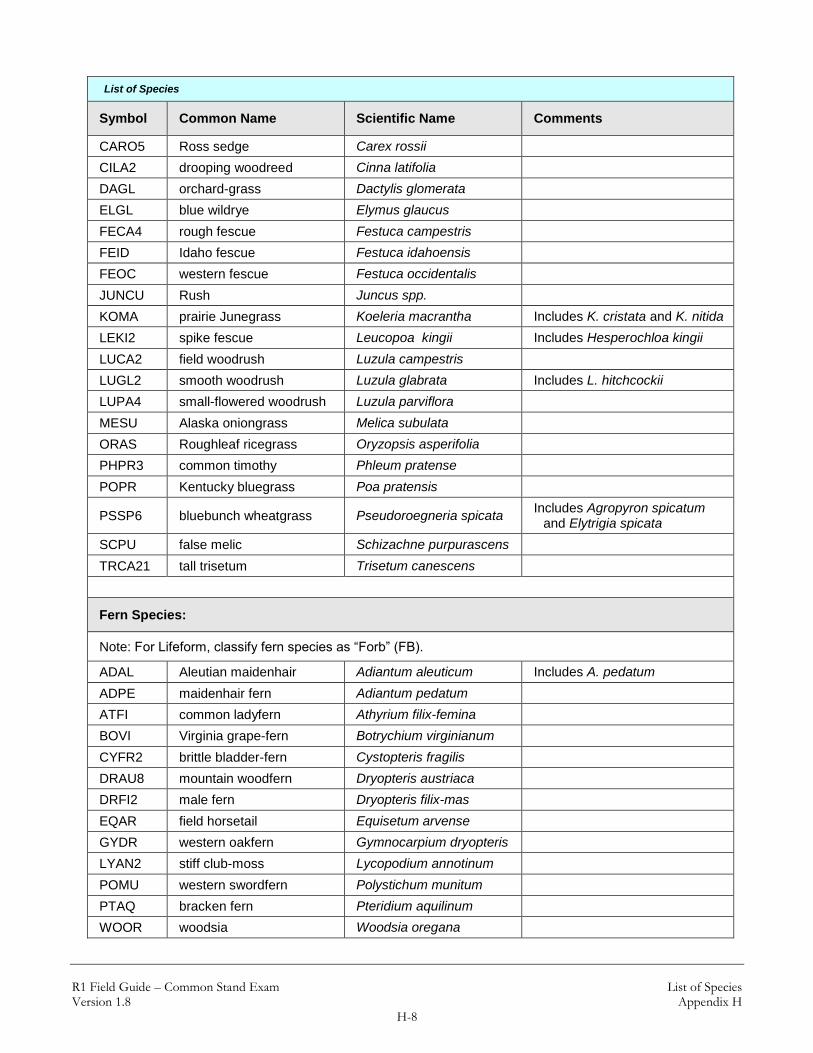
R1 Field Guide – Common Stand Exam List of Species Version 1.8 Appendix H
H-8
List of Species
Symbol Common Name Scientific Name Comments
CARO5 Ross sedge Carex rossii
CILA2 drooping woodreed Cinna latifolia
DAGL orchard-grass Dactylis glomerata
ELGL blue wildrye Elymus glaucus
FECA4 rough fescue Festuca campestris
FEID Idaho fescue Festuca idahoensis
FEOC western fescue Festuca occidentalis
JUNCU Rush Juncus spp.
KOMA prairie Junegrass Koeleria macrantha Includes K. cristata and K. nitida
LEKI2 spike fescue Leucopoa kingii Includes Hesperochloa kingii
LUCA2 field woodrush Luzula campestris
LUGL2 smooth woodrush Luzula glabrata Includes L. hitchcockii
LUPA4 small-flowered woodrush Luzula parviflora
MESU Alaska oniongrass Melica subulata
ORAS Roughleaf ricegrass Oryzopsis asperifolia
PHPR3 common timothy Phleum pratense
POPR Kentucky bluegrass Poa pratensis
PSSP6 bluebunch wheatgrass Pseudoroegneria spicata Includes Agropyron spicatum
and Elytrigia spicata
SCPU false melic Schizachne purpurascens
TRCA21 tall trisetum Trisetum canescens
Fern Species:
Note: For Lifeform, classify fern species as “Forb” (FB).
ADAL Aleutian maidenhair Adiantum aleuticum Includes A. pedatum
ADPE maidenhair fern Adiantum pedatum
ATFI common ladyfern Athyrium filix-femina
BOVI Virginia grape-fern Botrychium virginianum
CYFR2 brittle bladder-fern Cystopteris fragilis
DRAU8 mountain woodfern Dryopteris austriaca
DRFI2 male fern Dryopteris filix-mas
EQAR field horsetail Equisetum arvense
GYDR western oakfern Gymnocarpium dryopteris
LYAN2 stiff club-moss Lycopodium annotinum
POMU western swordfern Polystichum munitum
PTAQ bracken fern Pteridium aquilinum
WOOR woodsia Woodsia oregana

R1 Field Guide – Common Stand Exam Fuel Photo References and Codes Version 1.8 Appendix I
I-0
Appendix I: Fuel Photo References and Codes
Fuel Photo References and Codes
Reference Code
Fuel Photo Reference
1
Photo Guide for Appraising Downed Woody Fuels in Montana Forests: Grand fir - Larch - Douglas-fir, Western Redcedar Cover Types. 1981. Fischer, William C. Gen. Tech. Rep. INT-96. Ogden, UT: USDA Forest Service, Intermountain Forest and Range Experiment Station. 53 p.
2
Photo Guide for Appraising Downed Woody Fuels in Montana Forests: Interior Ponderosa Pine, Ponderosa Pine - Larch - Douglas-fir, Larch -Douglas-fir, and Interior Douglas-fir Cover Types. 1981. Fischer, William C. Gen. Tech. Rep. INT-97. Ogden, UT: USDA Forest Service, Intermountain Forest and Range Experiment Station. 133 p.
3
Photo Guide for Appraising Downed Woody Fuels in Montana Forests: Lodgepole Pine and Engelmann Spruce-Subalpine Fir Cover Types. 1981. Fischer, William C. Gen. Tech. Rep. INT-98. Ogden, UT: USDA Forest Service, Intermountain Forest and Range Experiment Station. 143 p.
4 Photo Guides for Appraising Downed Woody Fuels in Montana Forests: How
They Were Made. 1981. Fischer, William C. Research Note INT-299. Ogden, UT: USDA Forest Service, Intermountain Forest and Range Experiment Station. 12 p.
5
Photo series for Appraising Thinning Slash in North Idaho: Western Hemlock, Grand fir, and Western Redcedar Timber Types. 1979. Koski, Wayne H.; Fischer, William C. Gen. Tech. Rep. INT-46. Ogden, UT: USDA Forest Service, Intermountain Forest and Range Experiment Station. 50 p.
6
Photo series for Quantifying Forest Residues in the: Ponderosa Pine Type, Ponderosa Pine and associated species type, Lodgepole pine type. 1976. Maxwell, Wayne G.; Ward, Franklin R. Gen. Tech. Rep. PNW-52. Portland, OR: USDA Forest Service, Pacific Northwest Forest and Range Experiment Station. 74 p.
8
Photo Series for Quantifying Natural Forest Residues in Common Vegetation Types of the Pacific Northwest. 1980. Maxwell, Wayne G; Ward, Franklin R. Gen Tech. Rep. PNW-105. Portland, OR: USDA Forest Service, Pacific Northwest Forest and Range Experiment Station. 229 p.
10
Photo Series for Quantifying Forest Residues in: Douglas-fir, Engelmann Spruce Type, Limber Pine Type, Lodgepole Pine Type, Ponderosa Pine Type, Subalpine Fir Type for Eastern Montana. Mackay, Douglas H.; Stiger, Everett M.; Goss, Delman; Bonney, Byron. USDA Forest Service, Northern Region. 162 p

R1 Field Guide – Common Stand Exam Fuel Photo References and Codes Version 1.8 Appendix I
I-2
Associated Fuel Photo Codes:
Associated Fuel Photo Codes
Reference Code
Residue Code
1 3A
1 4A
1 5A
1 6A
1 7A
1 8A
1 9A
1 10A
1 11A
1 13A
1 15
1 15A
1 16
1 16A
1 17A
1 18A
1 19A
1 25
1 63
1 65
1 66
1 67
2 5
2 7
2 8
2 9
2 12A
2 13
2 14
2 14A
2 17
2 18
2 23
2 24
Associated Fuel Photo Codes
Reference Code
Residue Code
2 27A
2 28
2 28A
2 29
2 29A
2 30
2 30A
2 31
2 31A
2 32
2 32A
2 33
2 33A
2 34
2 37A
2 38A
2 39A
2 40A
2 41A
2 42
2 42A
2 43
2 43A
2 48
2 49
2 56
2 64
2 68
2 69
2 70
2 71
2 72
2 73
2 74
2 75
Associated Fuel Photo Codes
Reference Code
Residue Code
2 76
2 77
2 78
2 79
2 80
2 84
2 86
2 88
2 89
2 91
2 95
3 1
3 1A
3 2
3 2A
3 3
3 4
3 6
3 10
3 11
3 12
3 19
3 20
3 20A
3 21
3 21A
3 22
3 22A
3 23A
3 24A
3 25A
3 26
3 26A
3 27

R1 Field Guide – Common Stand Exam Fuel Photo References and Codes Version 1.8 Appendix I
I-3
Associated Fuel Photo Codes
Reference Code
Residue Code
3 34A
3 35
3 35A
3 36
3 37
3 38
3 39
3 40
3 41
3 44
3 44A
3 45
3 45A
3 46
3 46A
3 47
3 47A
3 48A
3 49A
3 50
3 51
3 53
3 54
3 55
3 57
3 58
3 59
3 60
3 61
3 62
3 81
3 82
3 83
3 85
3 87
3 90
3 92
Associated Fuel Photo Codes
Reference Code
Residue Code
3 93
3 94
3 96
3 97
3 98
6 1PP4CC
6 2PP4CC
6 1PP4PC
6 2PP4PC
6 3PP4PC
6 4PP4PC
6 5PP4PC
6 1PP1TH
6 2PP1TH
6 3PP1TH
6 4PP1TH
6 5PP1TH
6 6PP1TH
6 1PP&ASSOC4PC
6 2PP&ASSOC4PC
6 3PP&ASSOC4PC
6 4PP&ASSOC4PC
6 5PP&ASSOC4PC
6 6PP&ASSOC4PC
6 7PP&ASSOC4PC
6 8PP&ASSOC4PC
6 1LP3CC
6 1LP3PC
6 2LP3PC
6 3LP3PC
6 4LP3PC
6 5LP3PC
6 5PP&ASSOC4PC
6 6PP&ASSOC4PC
6 7PP&ASSOC4PC
6 8PP&ASSOC4PC
Associated Fuel Photo Codes
Reference Code
Residue Code
8 1BR
8 1DF2
8 1DF3
8 1DF4
8 1DFHD3
8 1DFHD4
8 1GR
8 1HD2
8 1JU2
8 1LP1
8 1LP2
8 1LP3
8 1MC2
8 1MC3
8 1MC4
8 1PP&ASSOC3
8 1PP&ASSOC4
8 1PP1
8 1PP2
8 1PP3
8 1PP4
8 1SA1
8 1SA2
8 1SA3
8 1SA4
8 2BR
8 2DF2
8 2DF3
8 2DF4
8 2DFHD3
8 2DFHD4
8 2GR
8 2HD2
8 2JU2
8 2LP1
8 2LP2

R1 Field Guide – Common Stand Exam Fuel Photo References and Codes Version 1.8 Appendix I
I-4
Associated Fuel Photo Codes
Reference Code
Residue Code
8 2LP3
8 2MC2
8 2MC3
8 2MC4
8 2PP&ASSOC3
8 2PP&ASSOC4
8 2PP1
8 2PP2
8 2PP3
8 2PP4
8 2SA1
8 2SA2
8 2SA3
8 2SA4
8 3DF4
8 3DFHD3
8 3DFHD4
8 3LP1
8 3LP2
8 3LP3
8 3MC2
Associated Fuel Photo Codes
Reference Code
Residue Code
8 3MC3
8 3PP&ASSOC3
8 3PP&ASSOC4
8 3PP1
8 3PP2
8 3PP3
8 3PP4
8 3SA1
8 3SA3
8 4DF4
8 4DFHD4
8 4LP2
8 4PP&ASSOC3
8 4PP2
8 4PP3
8 4PP4
8 5DF4
8 5DFHD4
8 5PP&ASSOC3
8 5PP3
8 5PP4
Associated Fuel Photo Codes
Reference Code
Residue Code
8 6DF4
8 6PP3
8 6PP4
8 7DF4
8 7PP3
8 7PP4
8 8PP3
8 8PP4

R1 Field Guide – Common Stand Exam Fixed-Radius Plot Version 1.8 Appendix J
J-1
Appendix J: Fixed-Radius Plot (slope correction; borderline trees) For all fixed-radius plots located on slopes ≥ 10 percent, it will be necessary to determine a “corrected” radius distance that is equivalent to the horizontal fixed-radius plot distance of the sample plot. To determine the “corrected” fixed-radius plot distance, refer to section A below. To determine the limiting distance for borderline trees located on slopes, and if the tree is “in” or “out” of the fixed-radius plot area, refer to section B below. A. Fixed-radius Plot Slope Correction
To determine the “corrected” plot radius for a fixed-plot area located on slope, complete the following steps:
1. Determine the average percent slope for the sample plot area (using a clinometer).
2. Use the "Circular Plot Radii Corrected for Slope" table below to determine the
corrected fixed-radius plot distance; values listed in the table are in feet. Find the row that contains the slope percent, and then locate the “corrected” radius distance under the appropriate column for the plot size.
Measure the “corrected” radius distance along the slope of the ground, or parallel to the ground line. This method always results in a circular plot on the slope.
Example:
Fixed-radius plot size – 1/300th acre Slope percent for sample area – 50 percent Corrected radius distance (value from table) – 7.2 feet

R1 Field Guide – Common Stand Exam Fixed-Radius Plot Version 1.8 Appendix J
J-2
Circular Plot Radii Corrected for Slope (radius distance – feet):
Circular Plot Radii Corrected for Slope (radius distance – feet)
Slope Percent
Plot Size in Acres
1/300 1/100 1/50 1/20 1/10 1/5
Horizontal
0-9 6.8 11.8 16.7 26.3 37.2 52.7
10-17 6.8 11.8 16.7 26.5 37.4 52.9
18-22 6.9 11.9 16.8 26.6 37.6 53.2
23-26 6.9 12.0 16.9 26.7 37.8 53.4
27-30 6.9 12.0 17.0 26.9 38.0 53.7
31-33 7.0 12.1 17.1 27.0 38.2 54.0
34-36 7.0 12.1 17.1 27.1 38.3 54.2
37-39 7.0 12.2 17.2 27.2 38.5 54.5
40-42 7.1 12.2 17.3 27.4 38.7 54.7
43-44 7.1 12.3 17.4 27.5 38.9 55.0
45-47 7.1 12.3 17.5 27.6 39.1 55.2
48-49 7.2 12.4 17.5 27.7 39.2 55.5
50-51 7.2 12.5 17.6 27.9 39.4 55.7
52-53 7.2 12.5 17.7 28.0 39.6 56.0
54-55 7.3 12.6 17.8 28.1 39.8 56.2
56-57 7.3 12.6 17.9 28.2 39.9 56.5
58-59 7.3 12.7 17.9 28.4 40.1 56.7
60-61 7.4 12.7 18.0 28.5 40.3 57.0
62-63 7.4 12.8 18.1 28.6 40.4 57.2
64-65 7.4 12.8 18.2 28.7 40.6 57.4
66-67 7.4 12.9 18.2 28.8 40.8 57.7
68-69 7.5 13.0 18.3 29.0 41.0 57.9
70 7.5 13.0 18.4 29.1 41.1 58.2
71-72 7.5 13.1 18.5 29.2 41.3 58.4
73-74 7.6 13.1 18.5 29.3 41.5 58.6
75 7.6 13.2 18.6 29.4 41.6 58.7
76-77 7.6 13.2 18.7 29.6 41.8 59.1
78-79 7.7 13.3 18.8 29.7 42.0 59.3
80 7.7 13.3 18.8 29.8 42.1 59.6
81-82 7.7 13.4 18.9 29.9 42.3 59.8
83 7.8 13.4 19.0 30.0 42.5 60.0
84-85 7.8 13.5 19.1 30.1 42.6 60.3
86 7.8 13.5 19.1 30.3 42.8 60.5
87-88 7.8 13.6 19.2 30.4 42.9 60.7

R1 Field Guide – Common Stand Exam Fixed-Radius Plot Version 1.8 Appendix J
J-3
Circular Plot Radii Corrected for Slope (radius distance – feet)
Slope Percent
Plot Size in Acres
1/300 1/100 1/50 1/20 1/10 1/5
89 7.9 13.6 19.3 30.5 43.1 61.0
90-91 7.9 13.7 19.3 30.6 43.3 61.2
92 7.9 13.7 19.4 30.7 43.4 61.4
93-94 8.0 13.8 19.5 30.8 43.6 61.6
95 8.0 13.8 19.6 30.9 43.7 61.9
96-97 8.0 13.9 19.6 31.0 43.9 62.1
98 8.0 13.9 19.7 31.2 44.1 62.3
99-100 8.1 14.0 19.8 31.3 44.2 62.5
101 8.1 14.0 19.8 31.4 44.4 62.8
102 8.1 14.1 19.9 31.5 44.5 63.0
103-104 8.2 14.1 20.0 31.6 44.7 63.2
105 8.2 14.2 20.1 31.7 44.8 63.4
106-107 8.2 14.2 20.1 31.8 45.0 63.6
108 8.2 14.3 20.2 31.9 45.1 63.8
109 8.3 14.3 20.3 32.0 45.3 64.1
110-111 8.3 14.4 20.3 32.1 45.5 64.3
112 8.3 14.4 20.4 32.2 45.6 64.5
113 8.4 14.5 20.5 32.4 45.8 64.7
114-115 8.4 14.5 20.5 32.5 45.9 64.9
116 8.4 14.6 20.6 32.6 46.1 65.1
117 8.4 14.6 20.7 32.7 46.2 65.3
118-119 8.5 14.7 20.7 32.8 46.4 65.6
120 8.5 14.7 20.8 32.9 46.5 65.8
121 8.5 14.8 20.9 33.0 46.7 66.0
122 8.5 14.8 20.9 33.1 46.8 66.2
123-124 8.6 14.8 21.0 33.2 47.0 66.4
125 8.6 14.9 21.1 33.3 47.1 66.6
130 8.7 15.1 21.3 33.7 47.7 67.4
135 8.8 15.3 21.6 34.1 48.3 68.3
140 8.9 15.4 21.8 34.5 48.8 69.1
145 9.0 15.6 22.1 34.9 49.4 69.9
150 9.1 15.8 22.3 35.3 50.0 70.7

R1 Field Guide – Common Stand Exam Fixed-Radius Plot Version 1.8 Appendix J
J-4
B. Determining Sample Status for Borderline Trees on a Slope (fixed-radius plot)
To determine if a borderline tree located on a slope is “in” or “out” of the fixed-radius plot area, complete the following steps:
1. Determine the slope percent from plot center to the borderline tree (using a clinometer). Note: This slope percent is not necessarily the same as the average slope percent for the overall sample area; measure slope parallel to the ground line.
2. Use the “Slope Correction Table” below to determine the slope correction factor
(SCF) associated with the slope percent to the borderline tree. 3. Compute the slope limiting distance using the following formula (horizontal fixed-
radius plot distances are listed below):
Slope Limiting Distance = horizontal fixed-radius plot distance x SCF
4. Measure the slope distance (parallel to the ground line) from plot center to the
geographic center (where tree comes out of the ground) of the borderline tree. If the measured distance is less than or equal to the “slope limiting distance,” then the tree is “in” the fixed-radius plot area and should be included in the sample. If the measured distance is greater than the “slope limiting distance,” then the tree is “out” of the fixed-radius plot area.
Example:
Fixed-radius plot size – 1/10th acre (horizontal plot radius = 37.2 feet) Slope percent from plot center to borderline tree – 25 percent SCF – 1.03 (value from table) Slope limiting distance:
Slope Limiting Distance = 37.2 feet x 1.03 = 38.3 feet
Measured slope distance from plot center to geographic center of borderline tree –
38.2 feet
The tree is “in” the fixed-radius plot sample area (the measured slope distance of 38.2 feet is less than or equal to the slope limiting distance of 38.3 feet).
This method always results in an oval plot on the slope.

R1 Field Guide – Common Stand Exam Fixed-Radius Plot Version 1.8 Appendix J
J-5
Horizontal fixed-radius plot distances:
Horizontal fixed-radius plot distances
Plot Size (acre)
Plot Radius
1/1000 3.7 feet
1/500 5.3 feet
1/400 5.9 feet
1/300 6.8 feet
1/250 7.4 feet
1/200 8.3 feet
1/150 9.6 feet
1/100 11.8 feet
1/50 16.7 feet
Horizontal fixed-radius plot distances
Plot Size (acre)
Plot Radius
1/24 24.0 feet
1/20 26.3 feet
1/10 37.2 feet
1/5 52.7 feet
1/4 58.9 feet
1/3 67.6 feet
1/2 83.3 feet
1 117.1 feet
Slope Correction Table:
Slope Correction Table
Percent of Slope
Degree of Slope
Slope Correction Factor (SCF)
0 to 9 0-6 1.00
10 to 17 7-10 1.01
18 to 22 11-12 1.02
23 to 26 13-14 1.03
27 to 30 15-17 1.04
31 to 33 18 1.05
34 to 36 19-20 1.06
37 to 39 21 1.07
40 to 42 22 1.08
43 to 44 23 1.09
45 to 47 24 1.10
48 to 49 25-26 1.11
50 to 51 27 1.12
52 to 53 28 1.13
54 to 55 29 1.14
56 to 57 29 1.15
58 to 59 30 1.16
60 to 61 31 1.17
Slope Correction Table
Percent of Slope
Degree of Slope
Slope Correction Factor (SCF)
62 to 63 32 1.18
64 to 65 33 1.19
66 to 67 34 1.20
68 to 69 34 1.21
70 35 1.22
71 to 72 36 1.23
73 to 74 37 1.24
75 37 1.25
76 to 77 38 1.26
78 to 79 38 1.27
80 39 1.28
81 to 82 39 1.29
83 40 1.30
84 to 85 40 1.31
86 41 1.32
87 to 88 41 1.33
89 42 1.34
90 to 91 42 1.35

R1 Field Guide – Common Stand Exam Fixed-Radius Plot Version 1.8 Appendix J
J-6
Slope Correction Table
Percent of Slope
Degree of Slope
Slope Correction Factor (SCF)
92 43 1.36
93 to 94 43 1.37
95 44 1.38
96 to 97 44 1.39
98 44 1.40
99 to 100 45 1.41
101 45 1.42
102 46 1.43
103 to 104 46 1.44
105 46 1.45
106 to 107 47 1.46
108 47 1.47
109 47 1.48
110 to 111 48 1.49
112 48 1.50
113 48 1.51
114 to 115 49 1.52
116 49 1.53
117 49 1.54
118 to 119 50 1.55
120 50 1.56
121 50 1.57
122 51 1.58
Slope Correction Table
Percent of Slope
Degree of Slope
Slope Correction Factor (SCF)
123 to 124 51 1.59
125 51 1.60
126 52 1.61
127 to 128 52 1.62
129 52 1.63
130 52 1.64
131 53 1.65
132 to 133 53 1.66
134 53 1.67
135 53 1.68
136 54 1.69
137 to 138 54 1.70
139 54 1.71
140 54 1.72
141 55 1.73
142 to 143 55 1.74
144 55 1.75
145 55 1.76
146 56 1.77
147 56 1.78
148 to 149 56 1.79
150 56 1.80

R1 Field Guide – Common Stand Exam Variable-Radius Plot Version 1.8 Appendix K
K-1
Appendix K: Variable-Radius Plot (borderline trees) Variable-radius plot sampling is a method that involves selection of trees with a probability proportional to their size. Under this sampling method, a plot center is established, and trees are selected for sample by rotating a fixed angle around the plot. The plot radius varies according to the diameter (DBH or DRC) and distance of each tree from plot center. The experienced field person using a wedge prism, angle gauge, or relaskop can quickly tell in most cases if a tree is “in" or "out" of the variable plot. However, there are certain trees that are questionable (borderline) for tally because they are located at the outer limits of the variable-plot radius. This narrative describes the procedures needed to ascertain if borderline trees qualify for tally. For information on the theory and mathematics of variable plot cruising; and formulas for determining the plot radius factor for any given BAF, refer to Log Scaling and Timber Cruising (1973, J. R. Dilworth, OSU Book Stores, Inc., Corvallis, Oregon). Measurement of Borderline Trees to Determine “In” or “Out” Status: In variable-radius plot sampling, limiting distance is a function of the selected basal area factor (e.g., 20 or 40) and the diameter of the tree. The limiting distance is the maximum distance that a tree can be from plot center and still qualify for tally. To determine if a borderline tree is “in” or “out” of the variable-radius plot area, complete the following steps. Refer to section A if the borderline tree is located on a slope that is < 10 percent. Refer to section B if the borderline tree is located a slope that is ≥ 10 percent. Note: For down-dead trees on a variable-radius plot, determine the sample status (“in” or “out”) based on where DBH (or DRC) now lies, not on where the tree once stood. Measure distance from plot center to the nearest face of the tree at DBH (or DRC).

R1 Field Guide – Common Stand Exam Variable-Radius Plot Version 1.8 Appendix K
K-2
A. Determining Sample Status for Borderline Trees (when slope is < 10 percent)
Tables K-1 through K-5 display horizontal limiting distances for various tree diameters and commonly used basal area factors (BAF). For these tables, limiting distance is measured from plot center to the face of the tree at DBH (or DRC) along a horizontal line; the table value is the maximum horizontal distance that a tree can be from plot center and still be considered ”in.” Procedure:
1. Measure the diameter of the tree to the nearest tenth of an inch. 2. Determine the horizontal limiting distance using one of the following options:
Option 1 – Refer to tables K-1 through K-5 (listed below); use the table that is applicable to the specified BAF. Locate the limiting distance value within the table based on the row and column for the tree diameter; the values listed are in feet.
Option 2 – Compute limiting distance using the following formula:
Limiting Distance = Plot Radius Factor x Diameter
Plot Radius Factors – limiting distance to face of tree
BAF 10 15 20 25 30 35 40 50 60
Plot Radius Factor*
2.708 2.203 1.902 1.697 1.546 1.428 1.333 1.188 1.081
* The plot radius factors (PRF) listed have been corrected for determining the
limiting distance to the face of the tree. A standard plot radius factor is used to determine limiting distance to the center of a tree, and is computed by 8.696/SQR(BAF). A corrected PRF subtracts 1/24 (.041666) from the standard plot radius factor.
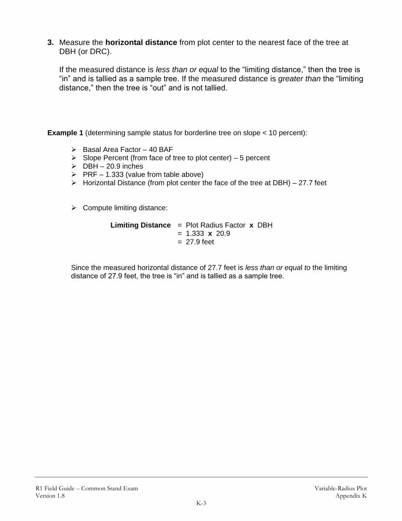
R1 Field Guide – Common Stand Exam Variable-Radius Plot Version 1.8 Appendix K
K-3
3. Measure the horizontal distance from plot center to the nearest face of the tree at DBH (or DRC). If the measured distance is less than or equal to the “limiting distance,” then the tree is “in” and is tallied as a sample tree. If the measured distance is greater than the “limiting distance,” then the tree is “out” and is not tallied.
Example 1 (determining sample status for borderline tree on slope < 10 percent):
Basal Area Factor – 40 BAF Slope Percent (from face of tree to plot center) – 5 percent DBH – 20.9 inches PRF – 1.333 (value from table above) Horizontal Distance (from plot center the face of the tree at DBH) – 27.7 feet
Compute limiting distance:
Limiting Distance = Plot Radius Factor x DBH = 1.333 x 20.9 = 27.9 feet
Since the measured horizontal distance of 27.7 feet is less than or equal to the limiting distance of 27.9 feet, the tree is “in” and is tallied as a sample tree.
R1 Field Guide – Common Stand Exam Variable-Radius Plot Version 1.8 Appendix K
K-4
B. Determining Sample Status for Borderline Trees (when slope is ≥ 10 percent)
Procedure:
1. Measure the diameter of the tree to the nearest tenth of an inch. 2. Measure the percent slope from the face of the tree at DBH (or DRC), nearest plot
center, to plot center. Note: This slope measurement and the distance measurement, from step 4 below, must be along the same line.
3. Determine the limiting distance using one of the following options:
Option 1 (use of table K-6)–
a. First, determine the slope corrected plot radius factor listed in table K-6 (refer to table below) – look under the “Combined Factor” column for the appropriate BAF. Locate the value associated with the percent slope from the face of the tree to plot center; this value will be referred to as the “Combined Factor” in the formula below.
b. Compute limiting distance using the following formula:
Limiting Distance = Diameter x “Combined Factor”
Option 2 (formulas)–
a. First, compute the slope correction factor (SCF) using the following formula (note: this value is also listed in table K-6 under the “Slope Correction Factor” column; locate the SCF associated with the percent slope from the face of the tree to plot center):
SCF = SQR (1 + (slope/100)2) b. Next, compute the slope corrected plot radius factor using the following
formula; plot radius factors (PRF) are listed above under step 3:
Slope Corrected PRF = Slope Correction Factor x PRF

R1 Field Guide – Common Stand Exam Variable-Radius Plot Version 1.8 Appendix K
K-5
c. Compute limiting distance using the following formula:
Limiting Distance = Slope Corrected PRF x Diameter
4. Measure the slope distance from plot center to the nearest face of the tree at DBH (or DRC). Note: This distance measurement and the slope percent measurement, from step 2 above, must be along the same line. If the measured distance is less than or equal to the “limiting distance,” then the tree is “in” and is tallied as a sample tree. If the measured distance is greater than the “limiting distance,” then the tree is “out” and is not tallied.
Example 2 (determining limiting distance for borderline tree on slope using formulas):
Basal Area Factor – 40 BAF Slope Percent (from face of tree at DBH to plot center) – 20 percent DBH – 20.9 inches PRF – 1.333 (value from table above)
Slope Correction Factor: = SQR (1 + (slope/100)2) = (1 + (20/100)2) = 1.0198 Slope Corrected PRF: = SCF x PRF = 1.0198 x 1.333 = 1.359 Limiting Distance: = Slope Corrected PRF x DBH = 1.359 x 20.9 = 28.4 feet

R1 Field Guide – Common Stand Exam Variable-Radius Plot Version 1.8 Appendix K
K-6
Example 3 (determining sample status for borderline tree on slope ≥ 10 percent – using table K-6):
Basal Area Factor – 40 BAF Slope Percent (from face of tree at DBH to plot center) – 50 percent DBH – 15.0 inches Slope Distance (from face of tree at DBH to plot center) – 21.0 feet
Figure K-1 – Determining limiting distance on a slope.
The “Combined Factor” for a slope of 50 percent with a 40 BAF is 1.490 (referring to table K-6).
Limiting Distance = DBH x “Combined Factor” = 15.0 x 1.490 = 22.35 feet
Since the measured slope distance of 21.0 feet is less than or equal to the limiting distance of 22.35 feet, the tree is “in” and is tallied as a sample tree.

R1 Field Guide – Common Stand Exam Variable-Radius Plot Version 1.8 Appendix K
K-7
Table K-1: BAF 10 plot radii from plot center to face of tree at DBH for 0% slope (in feet)
10 BAF
Inches 0 0.1 0.2 0.3 0.4 0.5 0.6 0.7 0.8 0.9
5 13.5 13.8 14.1 14.4 14.6 14.9 15.2 15.4 15.7 16.0
6 16.2 16.5 16.8 17.1 17.3 17.6 17.9 18.1 18.4 18.7
7 19.0 19.2 19.5 19.8 20.0 20.3 20.6 20.9 21.1 21.4
8 21.7 21.9 22.2 22.5 22.7 23.0 23.3 23.6 23.8 24.1
9 24.4 24.6 24.9 25.2 25.5 25.7 26.0 26.3 26.5 26.8
10 27.1 27.4 27.6 27.9 28.2 28.4 28.7 29.0 29.2 29.5
11 29.8 30.1 30.3 30.6 30.9 31.1 31.4 31.7 32.0 32.2
12 32.5 32.8 33.0 33.3 33.6 33.9 34.1 34.4 34.7 34.9
13 35.2 35.5 35.7 36.0 36.3 36.6 36.8 37.1 37.4 37.6
14 37.9 38.2 38.5 38.7 39.0 39.3 39.5 39.8 40.1 40.3
15 40.6 40.9 41.2 41.4 41.7 42.0 42.2 42.5 42.8 43.1
16 43.3 43.6 43.9 44.1 44.4 44.7 45.0 45.2 45.5 45.8
17 46.0 46.3 46.6 46.8 47.1 47.4 47.7 47.9 48.2 48.5
18 48.7 49.0 49.3 49.6 49.8 50.1 50.4 50.6 50.9 51.2
19 51.5 51.7 52.0 52.3 52.5 52.8 53.1 53.3 53.6 53.9
20 54.2 54.4 54.7 55.0 55.2 55.5 55.8 56.1 56.3 56.6
21 56.9 57.1 57.4 57.7 58.0 58.2 58.5 58.8 59.0 59.3
22 59.6 59.8 60.1 60.4 60.7 60.9 61.2 61.5 61.7 62.0
23 62.3 62.6 62.8 63.1 63.4 63.6 63.9 64.2 64.5 64.7
24 65.0 65.3 65.5 65.8 66.1 66.3 66.6 66.9 67.2 67.4
25 67.7 68.0 68.2 68.5 68.8 69.1 69.3 69.6 69.9 70.1
26 70.4 70.7 70.9 71.2 71.5 71.8 72.0 72.3 72.6 72.8
27 73.1 73.4 73.7 73.9 74.2 74.5 74.7 75.0 75.3 75.6
28 75.8 76.1 76.4 76.6 76.9 77.2 77.4 77.7 78.0 78.3
29 78.5 78.8 79.1 79.3 79.6 79.9 80.2 80.4 80.7 81.0
30 81.2 81.5 81.8 82.1 82.3 82.6 82.9 83.1 83.4 83.7
31 83.9 84.2 84.5 84.8 85.0 85.3 85.6 85.8 86.1 86.4
32 86.7 86.9 87.2 87.5 87.7 88.0 88.3 88.6 88.8 89.1
33 89.4 89.6 89.9 90.2 90.4 90.7 91.0 91.3 91.5 91.8
34 92.1 92.3 92.6 92.9 93.2 93.4 93.7 94.0 94.2 94.5
35 94.8 95.1 95.3 95.6 95.9 96.1 96.4 96.7 96.9 97.2
36 97.5 97.8 98.0 98.3 98.6 98.8 99.1 99.4 99.7 99.9
37 100.2 100.5 100.7 101.0 101.3 101.6 101.8 102.1 102.4 102.6
38 102.9 103.2 103.4 103.7 104.0 104.3 104.5 104.8 105.1 105.3
39 105.6 105.9 106.2 106.4 106.7 107.0 107.2 107.5 107.8 108.0
40 108.3 108.6 108.9 109.1 109.4 109.7 109.9 110.2 110.5 110.8
41 111.0 111.3 111.6 111.8 112.1 112.4 112.7 112.9 113.2 113.5
42 113.7 114.0 114.3 114.5 114.8 115.1 115.4 115.6 115.9 116.2
43 116.4 116.7 117.0 117.3 117.5 117.8 118.1 118.3 118.6 118.9
44 119.2 119.4 119.7 120.0 120.2 120.5 120.8 121.0 121.3 121.6
45 121.9 122.1 122.4 122.7 122.9 123.2 123.5 123.8 124.0 124.3
46 124.6 124.8 125.1 125.4 125.7 125.9 126.2 126.5 126.7 127.0
47 127.3 127.5 127.8 128.1 128.4 128.6 128.9 129.2 129.4 129.7
48 130.0 130.3 130.5 130.8 131.1 131.3 131.6 131.9 132.2 132.4
49 132.7 133.0 133.2 133.5 133.8 134.0 134.3 134.6 134.9 135.1
50 135.4 135.7 135.9 136.2 136.5 136.8 137.0 137.3 137.6 137.8
Prepared by multiplying the BAF 10 Plot Radius Factor 2.708 * DBH. For example, if DBH = 14.3 inches, then 2.708 * 14.3 = 38.7 feet

R1 Field Guide – Common Stand Exam Variable-Radius Plot Version 1.8 Appendix K
K-8
Table K-2: BAF 20 plot radii from plot center to face of tree at DBH for 0% slope (in feet)
20 BAF
Inches 0 0.1 0.2 0.3 0.4 0.5 0.6 0.7 0.8 0.9
5 9.5 9.7 9.9 10.1 10.3 10.5 10.7 10.8 11.0 11.2
6 11.4 11.6 11.8 12.0 12.2 12.4 12.6 12.8 12.9 13.1
7 13.3 13.5 13.7 13.9 14.1 14.3 14.5 14.7 14.8 15.0
8 15.2 15.4 15.6 15.8 16.0 16.2 16.4 16.6 16.7 16.9
9 17.1 17.3 17.5 17.7 17.9 18.1 18.3 18.5 18.6 18.8
10 19.0 19.2 19.4 19.6 19.8 20.0 20.2 20.4 20.6 20.7
11 20.9 21.1 21.3 21.5 21.7 21.9 22.1 22.3 22.5 22.6
12 22.8 23.0 23.2 23.4 23.6 23.8 24.0 24.2 24.4 24.5
13 24.7 24.9 25.1 25.3 25.5 25.7 25.9 26.1 26.3 26.5
14 26.6 26.8 27.0 27.2 27.4 27.6 27.8 28.0 28.2 28.4
15 28.5 28.7 28.9 29.1 29.3 29.5 29.7 29.9 30.1 30.3
16 30.4 30.6 30.8 31.0 31.2 31.4 31.6 31.8 32.0 32.2
17 32.4 32.5 32.7 32.9 33.1 33.3 33.5 33.7 33.9 34.1
18 34.3 34.4 34.6 34.8 35.0 35.2 35.4 35.6 35.8 36.0
19 36.2 36.3 36.5 36.7 36.9 37.1 37.3 37.5 37.7 37.9
20 38.1 38.3 38.4 38.6 38.8 39.0 39.2 39.4 39.6 39.8
21 40.0 40.2 40.3 40.5 40.7 40.9 41.1 41.3 41.5 41.7
22 41.9 42.1 42.2 42.4 42.6 42.8 43.0 43.2 43.4 43.6
23 43.8 44.0 44.1 44.3 44.5 44.7 44.9 45.1 45.3 45.5
24 45.7 45.9 46.1 46.2 46.4 46.6 46.8 47.0 47.2 47.4
25 47.6 47.8 48.0 48.1 48.3 48.5 48.7 48.9 49.1 49.3
26 49.5 49.7 49.9 50.0 50.2 50.4 50.6 50.8 51.0 51.2
27 51.4 51.6 51.8 52.0 52.1 52.3 52.5 52.7 52.9 53.1
28 53.3 53.5 53.7 53.9 54.0 54.2 54.4 54.6 54.8 55.0
29 55.2 55.4 55.6 55.8 55.9 56.1 56.3 56.5 56.7 56.9
30 57.1 57.3 57.5 57.7 57.9 58.0 58.2 58.4 58.6 58.8
31 59.0 59.2 59.4 59.6 59.8 59.9 60.1 60.3 60.5 60.7
32 60.9 61.1 61.3 61.5 61.7 61.8 62.0 62.2 62.4 62.6
33 62.8 63.0 63.2 63.4 63.6 63.8 63.9 64.1 64.3 64.5
34 64.7 64.9 65.1 65.3 65.5 65.7 65.8 66.0 66.2 66.4
35 66.6 66.8 67.0 67.2 67.4 67.6 67.7 67.9 68.1 68.3
36 68.5 68.7 68.9 69.1 69.3 69.5 69.6 69.8 70.0 70.2
37 70.4 70.6 70.8 71.0 71.2 71.4 71.6 71.7 71.9 72.1
38 72.3 72.5 72.7 72.9 73.1 73.3 73.5 73.6 73.8 74.0
39 74.2 74.4 74.6 74.8 75.0 75.2 75.4 75.5 75.7 75.9
40 76.1 76.3 76.5 76.7 76.9 77.1 77.3 77.5 77.6 77.8
41 78.0 78.2 78.4 78.6 78.8 79.0 79.2 79.4 79.5 79.7
42 79.9 80.1 80.3 80.5 80.7 80.9 81.1 81.3 81.4 81.6
43 81.8 82.0 82.2 82.4 82.6 82.8 83.0 83.2 83.4 83.5
44 83.7 83.9 84.1 84.3 84.5 84.7 84.9 85.1 85.3 85.4
45 85.6 85.8 86.0 86.2 86.4 86.6 86.8 87.0 87.2 87.3
46 87.5 87.7 87.9 88.1 88.3 88.5 88.7 88.9 89.1 89.3
47 89.4 89.6 89.8 90.0 90.2 90.4 90.6 90.8 91.0 91.2
48 91.3 91.5 91.7 91.9 92.1 92.3 92.5 92.7 92.9 93.1
49 93.2 93.4 93.6 93.8 94.0 94.2 94.4 94.6 94.8 95.0
50 95.2 95.3 95.5 95.7 95.9 96.1 96.3 96.5 96.7 96.9
Prepared by multiplying the BAF 20 Plot Radius Factor 1.902 * DBH. For example, if DBH = 14.3 inches, then 1.902 * 14.3 = 27.2

R1 Field Guide – Common Stand Exam Variable-Radius Plot Version 1.8 Appendix K
K-9
Table K-3: BAF 30 plot radii from plot center to face of tree at DBH for 0% slope (in feet)
30 BAF
Inches 0 0.1 0.2 0.3 0.4 0.5 0.6 0.7 0.8 0.9
5 7.7 7.9 8.0 8.2 8.3 8.5 8.7 8.8 9.0 9.1
6 9.3 9.4 9.6 9.7 9.9 10.0 10.2 10.4 10.5 10.7
7 10.8 11.0 11.1 11.3 11.4 11.6 11.7 11.9 12.1 12.2
8 12.4 12.5 12.7 12.8 13.0 13.1 13.3 13.5 13.6 13.8
9 13.9 14.1 14.2 14.4 14.5 14.7 14.8 15.0 15.2 15.3
10 15.5 15.6 15.8 15.9 16.1 16.2 16.4 16.5 16.7 16.9
11 17.0 17.2 17.3 17.5 17.6 17.8 17.9 18.1 18.2 18.4
12 18.6 18.7 18.9 19.0 19.2 19.3 19.5 19.6 19.8 19.9
13 20.1 20.3 20.4 20.6 20.7 20.9 21.0 21.2 21.3 21.5
14 21.6 21.8 22.0 22.1 22.3 22.4 22.6 22.7 22.9 23.0
15 23.2 23.3 23.5 23.7 23.8 24.0 24.1 24.3 24.4 24.6
16 24.7 24.9 25.0 25.2 25.4 25.5 25.7 25.8 26.0 26.1
17 26.3 26.4 26.6 26.7 26.9 27.1 27.2 27.4 27.5 27.7
18 27.8 28.0 28.1 28.3 28.4 28.6 28.8 28.9 29.1 29.2
19 29.4 29.5 29.7 29.8 30.0 30.1 30.3 30.5 30.6 30.8
20 30.9 31.1 31.2 31.4 31.5 31.7 31.8 32.0 32.2 32.3
21 32.5 32.6 32.8 32.9 33.1 33.2 33.4 33.5 33.7 33.9
22 34.0 34.2 34.3 34.5 34.6 34.8 34.9 35.1 35.2 35.4
23 35.6 35.7 35.9 36.0 36.2 36.3 36.5 36.6 36.8 36.9
24 37.1 37.3 37.4 37.6 37.7 37.9 38.0 38.2 38.3 38.5
25 38.7 38.8 39.0 39.1 39.3 39.4 39.6 39.7 39.9 40.0
26 40.2 40.4 40.5 40.7 40.8 41.0 41.1 41.3 41.4 41.6
27 41.7 41.9 42.1 42.2 42.4 42.5 42.7 42.8 43.0 43.1
28 43.3 43.4 43.6 43.8 43.9 44.1 44.2 44.4 44.5 44.7
29 44.8 45.0 45.1 45.3 45.5 45.6 45.8 45.9 46.1 46.2
30 46.4 46.5 46.7 46.8 47.0 47.2 47.3 47.5 47.6 47.8
31 47.9 48.1 48.2 48.4 48.5 48.7 48.9 49.0 49.2 49.3
32 49.5 49.6 49.8 49.9 50.1 50.2 50.4 50.6 50.7 50.9
33 51.0 51.2 51.3 51.5 51.6 51.8 51.9 52.1 52.3 52.4
34 52.6 52.7 52.9 53.0 53.2 53.3 53.5 53.6 53.8 54.0
35 54.1 54.3 54.4 54.6 54.7 54.9 55.0 55.2 55.3 55.5
36 55.7 55.8 56.0 56.1 56.3 56.4 56.6 56.7 56.9 57.0
37 57.2 57.4 57.5 57.7 57.8 58.0 58.1 58.3 58.4 58.6
38 58.7 58.9 59.1 59.2 59.4 59.5 59.7 59.8 60.0 60.1
39 60.3 60.4 60.6 60.8 60.9 61.1 61.2 61.4 61.5 61.7
40 61.8 62.0 62.1 62.3 62.5 62.6 62.8 62.9 63.1 63.2
41 63.4 63.5 63.7 63.8 64.0 64.2 64.3 64.5 64.6 64.8
42 64.9 65.1 65.2 65.4 65.6 65.7 65.9 66.0 66.2 66.3
43 66.5 66.6 66.8 66.9 67.1 67.3 67.4 67.6 67.7 67.9
44 68.0 68.2 68.3 68.5 68.6 68.8 69.0 69.1 69.3 69.4
45 69.6 69.7 69.9 70.0 70.2 70.3 70.5 70.7 70.8 71.0
46 71.1 71.3 71.4 71.6 71.7 71.9 72.0 72.2 72.4 72.5
47 72.7 72.8 73.0 73.1 73.3 73.4 73.6 73.7 73.9 74.1
48 74.2 74.4 74.5 74.7 74.8 75.0 75.1 75.3 75.4 75.6
49 75.8 75.9 76.1 76.2 76.4 76.5 76.7 76.8 77.0 77.1
50 77.3 77.5 77.6 77.8 77.9 78.1 78.2 78.4 78.5 78.7
Prepared by multiplying the BAF 30 Plot Radius Factor 1.546 * DBH. For example, if DBH = 14.3 inches, then 1.546 * 14.3 = 22.1
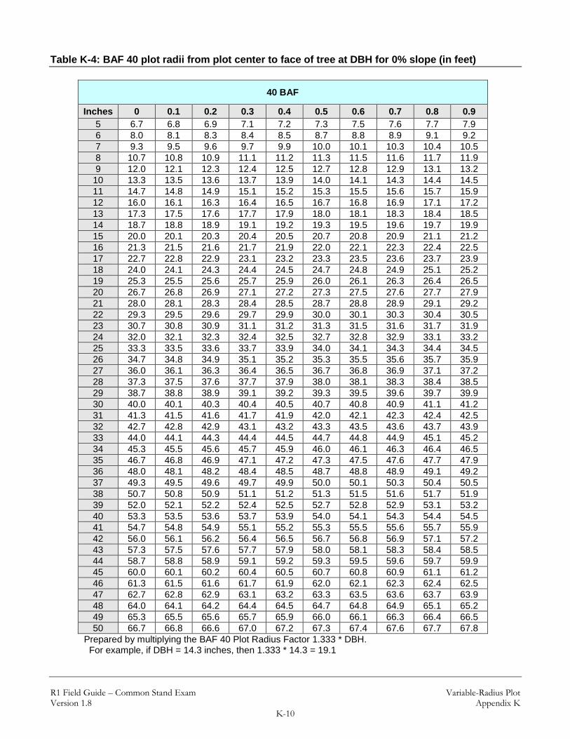
R1 Field Guide – Common Stand Exam Variable-Radius Plot Version 1.8 Appendix K
K-10
Table K-4: BAF 40 plot radii from plot center to face of tree at DBH for 0% slope (in feet)
40 BAF
Inches 0 0.1 0.2 0.3 0.4 0.5 0.6 0.7 0.8 0.9
5 6.7 6.8 6.9 7.1 7.2 7.3 7.5 7.6 7.7 7.9
6 8.0 8.1 8.3 8.4 8.5 8.7 8.8 8.9 9.1 9.2
7 9.3 9.5 9.6 9.7 9.9 10.0 10.1 10.3 10.4 10.5
8 10.7 10.8 10.9 11.1 11.2 11.3 11.5 11.6 11.7 11.9
9 12.0 12.1 12.3 12.4 12.5 12.7 12.8 12.9 13.1 13.2
10 13.3 13.5 13.6 13.7 13.9 14.0 14.1 14.3 14.4 14.5
11 14.7 14.8 14.9 15.1 15.2 15.3 15.5 15.6 15.7 15.9
12 16.0 16.1 16.3 16.4 16.5 16.7 16.8 16.9 17.1 17.2
13 17.3 17.5 17.6 17.7 17.9 18.0 18.1 18.3 18.4 18.5
14 18.7 18.8 18.9 19.1 19.2 19.3 19.5 19.6 19.7 19.9
15 20.0 20.1 20.3 20.4 20.5 20.7 20.8 20.9 21.1 21.2
16 21.3 21.5 21.6 21.7 21.9 22.0 22.1 22.3 22.4 22.5
17 22.7 22.8 22.9 23.1 23.2 23.3 23.5 23.6 23.7 23.9
18 24.0 24.1 24.3 24.4 24.5 24.7 24.8 24.9 25.1 25.2
19 25.3 25.5 25.6 25.7 25.9 26.0 26.1 26.3 26.4 26.5
20 26.7 26.8 26.9 27.1 27.2 27.3 27.5 27.6 27.7 27.9
21 28.0 28.1 28.3 28.4 28.5 28.7 28.8 28.9 29.1 29.2
22 29.3 29.5 29.6 29.7 29.9 30.0 30.1 30.3 30.4 30.5
23 30.7 30.8 30.9 31.1 31.2 31.3 31.5 31.6 31.7 31.9
24 32.0 32.1 32.3 32.4 32.5 32.7 32.8 32.9 33.1 33.2
25 33.3 33.5 33.6 33.7 33.9 34.0 34.1 34.3 34.4 34.5
26 34.7 34.8 34.9 35.1 35.2 35.3 35.5 35.6 35.7 35.9
27 36.0 36.1 36.3 36.4 36.5 36.7 36.8 36.9 37.1 37.2
28 37.3 37.5 37.6 37.7 37.9 38.0 38.1 38.3 38.4 38.5
29 38.7 38.8 38.9 39.1 39.2 39.3 39.5 39.6 39.7 39.9
30 40.0 40.1 40.3 40.4 40.5 40.7 40.8 40.9 41.1 41.2
31 41.3 41.5 41.6 41.7 41.9 42.0 42.1 42.3 42.4 42.5
32 42.7 42.8 42.9 43.1 43.2 43.3 43.5 43.6 43.7 43.9
33 44.0 44.1 44.3 44.4 44.5 44.7 44.8 44.9 45.1 45.2
34 45.3 45.5 45.6 45.7 45.9 46.0 46.1 46.3 46.4 46.5
35 46.7 46.8 46.9 47.1 47.2 47.3 47.5 47.6 47.7 47.9
36 48.0 48.1 48.2 48.4 48.5 48.7 48.8 48.9 49.1 49.2
37 49.3 49.5 49.6 49.7 49.9 50.0 50.1 50.3 50.4 50.5
38 50.7 50.8 50.9 51.1 51.2 51.3 51.5 51.6 51.7 51.9
39 52.0 52.1 52.2 52.4 52.5 52.7 52.8 52.9 53.1 53.2
40 53.3 53.5 53.6 53.7 53.9 54.0 54.1 54.3 54.4 54.5
41 54.7 54.8 54.9 55.1 55.2 55.3 55.5 55.6 55.7 55.9
42 56.0 56.1 56.2 56.4 56.5 56.7 56.8 56.9 57.1 57.2
43 57.3 57.5 57.6 57.7 57.9 58.0 58.1 58.3 58.4 58.5
44 58.7 58.8 58.9 59.1 59.2 59.3 59.5 59.6 59.7 59.9
45 60.0 60.1 60.2 60.4 60.5 60.7 60.8 60.9 61.1 61.2
46 61.3 61.5 61.6 61.7 61.9 62.0 62.1 62.3 62.4 62.5
47 62.7 62.8 62.9 63.1 63.2 63.3 63.5 63.6 63.7 63.9
48 64.0 64.1 64.2 64.4 64.5 64.7 64.8 64.9 65.1 65.2
49 65.3 65.5 65.6 65.7 65.9 66.0 66.1 66.3 66.4 66.5
50 66.7 66.8 66.6 67.0 67.2 67.3 67.4 67.6 67.7 67.8
Prepared by multiplying the BAF 40 Plot Radius Factor 1.333 * DBH. For example, if DBH = 14.3 inches, then 1.333 * 14.3 = 19.1

R1 Field Guide – Common Stand Exam Variable-Radius Plot Version 1.8 Appendix K
K-11
Table K-5: BAF 60 plot radii from plot center to face of tree at DBH for 0% slope (in feet)
60 BAF
Inches 0 0.1 0.2 0.3 0.4 0.5 0.6 0.7 0.8 0.9
5 5.4 5.5 5.6 5.7 5.8 5.9 6.1 6.2 6.3 6.4
6 6.5 6.6 6.7 6.8 6.9 7.0 7.1 7.2 7.4 7.5
7 7.6 7.7 7.8 7.9 8.0 8.1 8.2 8.3 8.4 8.5
8 8.6 8.8 8.9 9.0 9.1 9.2 9.3 9.4 9.5 9.6
9 9.7 9.8 9.9 10.1 10.2 10.3 10.4 10.5 10.6 10.7
10 10.8 10.9 11.0 11.1 11.2 11.4 11.5 11.6 11.7 11.8
11 11.9 12.0 12.1 12.2 12.3 12.4 12.5 12.6 12.8 12.9
12 13.0 13.1 13.2 13.3 13.4 13.5 13.6 13.7 13.8 13.9
13 14.1 14.2 14.3 14.4 14.5 14.6 14.7 14.8 14.9 15.0
14 15.1 15.2 15.4 15.5 15.6 15.7 15.8 15.9 16.0 16.1
15 16.2 16.3 16.4 16.5 16.6 16.8 16.9 17.0 17.1 17.2
16 17.3 17.4 17.5 17.6 17.7 17.8 17.9 18.1 18.2 18.3
17 18.4 18.5 18.6 18.7 18.8 18.9 19.0 19.1 19.2 19.3
18 19.5 19.6 19.7 19.8 19.9 20.0 20.1 20.2 20.3 20.4
19 20.5 20.6 20.8 20.9 21.0 21.1 21.2 21.3 21.4 21.5
20 21.6 21.7 21.8 21.9 22.1 22.2 22.3 22.4 22.5 22.6
21 22.7 22.8 22.9 23.0 23.1 23.2 23.3 23.5 23.6 23.7
22 23.8 23.9 24.0 24.1 24.2 24.3 24.4 24.5 24.6 24.8
23 24.9 25.0 25.1 25.2 25.3 25.4 25.5 25.6 25.7 25.8
24 25.9 26.1 26.2 26.3 26.4 26.5 26.6 26.7 26.8 26.9
25 27.0 27.1 27.2 27.3 27.5 27.6 27.7 27.8 27.9 28.0
26 28.1 28.2 28.3 28.4 28.5 28.6 28.8 28.9 29.0 29.1
27 29.2 29.3 29.4 29.5 29.6 29.7 29.8 29.9 30.1 30.2
28 30.3 30.4 30.5 30.6 30.7 30.8 30.9 31.0 31.1 31.2
29 31.3 31.5 31.6 31.7 31.8 31.9 32.0 32.1 32.2 32.3
30 32.4 32.5 32.6 32.8 32.9 33.0 33.1 33.2 33.3 33.4
31 33.5 33.6 33.7 33.8 33.9 34.1 34.2 34.3 34.4 34.5
32 34.6 34.7 34.8 34.9 35.0 35.1 35.2 35.3 35.5 35.6
33 35.7 35.8 35.9 36.0 36.1 36.2 36.3 36.4 36.5 36.6
34 36.8 36.9 37.0 37.1 37.2 37.3 37.4 37.5 37.6 37.7
35 37.8 37.9 38.1 38.2 38.3 38.4 38.5 38.6 38.7 38.8
36 38.9 39.0 39.1 39.2 39.3 39.5 39.6 39.7 39.8 39.9
37 40.0 40.1 40.2 40.3 40.4 40.5 40.6 40.8 40.9 41.0
38 41.1 41.2 41.3 41.4 41.5 41.6 41.7 41.8 41.9 42.1
39 42.2 42.3 42.4 42.5 42.6 42.7 42.8 42.9 43.0 43.1
40 43.2 43.3 43.5 43.6 43.7 43.8 43.9 44.0 44.1 44.2
41 44.3 44.4 44.5 44.6 44.8 44.9 45.0 45.1 45.2 45.3
42 45.4 45.5 45.6 45.7 45.8 45.9 46.1 46.2 46.3 46.4
43 46.5 46.6 46.7 46.8 46.9 47.0 47.1 47.2 47.3 47.5
44 47.6 47.7 47.8 47.9 48.0 48.1 48.2 48.3 48.4 48.5
45 48.6 48.8 48.9 49.0 49.1 49.2 49.3 49.4 49.5 49.6
46 49.7 49.8 49.9 50.1 50.2 50.3 50.4 50.5 50.6 50.7
47 50.8 50.9 51.0 51.1 51.2 51.3 51.5 51.6 51.7 51.8
48 51.9 52.0 52.1 52.2 52.3 52.4 52.5 52.6 52.8 52.9
49 53.0 53.1 53.2 53.3 53.4 53.5 53.6 53.7 53.8 53.9
50 54.1 54.2 54.3 54.4 54.5 54.6 54.7 54.8 54.9 55.0
Prepared by multiplying the BAF 60 Plot Radius Factor 1.081 * DBH. For example, if DBH = 14.3 inches, then 1.081 * 14.3 = 15.5

R1 Field Guide – Common Stand Exam Variable-Radius Plot Version 1.8 Appendix K
K-12
Table K-6: Limiting distance to face of tree for various basal area factors This table provides an expanded list of slope correction factors (SCF) to the face of the tree for use with various basal area factors. To use the table, measure the slope and the distance from plot center to the face of the tree at DBH. To obtain the corrected limiting distance to a tree, multiply DBH by the "Combined Factor" shown under the appropriate BAF heading.
Combined Factors – limiting distance to face of tree
Percent
Slope SCF
Combined Factor
5 BAF 10 BAF 15 BAF 20 BAF 30 BAF 40 BAF
1 1.00000 3.847 2.708 2.203 1.902 1.546 1.333
2 1.00020 3.848 2.709 2.203 1.902 1.546 1.333
3 1.00045 3.849 2.709 2.204 1.903 1.547 1.334
4 1.00080 3.850 2.710 2.205 1.904 1.547 1.334
5 1.00125 3.852 2.711 2.206 1.904 1.548 1.335
6 1.00180 3.854 2.713 2.207 1.905 1.549 1.335
7 1.00245 3.856 2.715 2.208 1.907 1.550 1.336
8 1.00319 3.859 2.717 2.210 1.908 1.551 1.337
9 1.00404 3.863 2.719 2.212 1.910 1.552 1.338
10 1.00499 3.866 2.722 2.214 1.911 1.554 1.340
11 1.00603 3.870 2.724 2.216 1.912 1.555 1.341
12 1.00717 3.875 2.727 2.219 1.916 1.557 1.343
13 1.00841 3.879 2.731 2.222 1.918 1.559 1.344
14 1.00975 3.884 2.734 2.224 1.921 1.567 1.346
15 1.01119 3.890 2.738 2.228 1.923 1.563 1.348
16 1.01272 3.896 2.742 2.231 1.926 1.566 1.350
17 1.01435 3.902 2.747 2.235 1.921 1.568 1.352
18 1.01607 3.909 2.752 2.238 1.933 1.571 1.354
19 1.01789 3.916 2.756 2.245 1.936 1.574 1.357
20 1.01980 3.923 2.762 2.245 1.940 1.577 1.359
21 1.02181 3.931 2.767 2.251 1.943 1.580 1.362
22 1.02391 3.939 2.773 2.256 1.947 1.583 1.365
23 1.02611 3.947 2.779 2.261 1.952 1.586 1.368
24 1.02840 3.956 2.785 2.266 1.956 1.590 1.371
25 1.03078 3.965 2.791 2.271 1.967 1.594 1.374
26 1.03325 3.975 2.798 2.276 1.965 1.597 1.377
27 1.03581 3.985 2.805 2.282 1.970 1.601 1.381
28 1.03846 3.995 2.812 2.288 1.975 1.605 1.384
29 1.04120 4.005 2.820 2.294 1.980 1.610 1.388
30 1.04403 4.016 2.827 2.300 1.986 1.614 1.392
31 1.04695 4.028 2.835 2.306 1.991 1.619 1.396
32 1.04995 4.039 2.843 2.313 1.997 1.623 1.400

R1 Field Guide – Common Stand Exam Variable-Radius Plot Version 1.8 Appendix K
K-13
Combined Factors – limiting distance to face of tree
Percent
Slope SCF
Combined Factor
5 BAF 10 BAF 15 BAF 20 BAF 30 BAF 40 BAF
33 1.05304 4.051 2.852 2.320 2.003 1.628 1.404
34 1.05622 4.063 2.960 2.327 2.009 1.633 1.408
35 1.05948 4.076 2.869 2.334 2.015 1.638 1.412
36 1.06283 4.089 2.878 2.341 2.022 1.643 1.417
37 1.06626 4.102 2.887 2.349 2.028 1.648 1.421
38 1.06977 4.115 2.897 2.357 2.035 1.654 1.426
39 1.07336 4.129 2.907 2.365 2.042 1.659 1.431
40 1.07703 4.143 2.917 2.373 2.049 1.665 1.436
41 1.08079 4.158 2.927 2.381 2.056 1.671 1.441
42 1.08462 4.173 2.937 2.389 2.063 1.677 1.446
43 1.08853 4.188 2.948 2.398 2.070 1.683 1.451
44 1.09252 4.203 2.959 2.407 2.078 1.689 1.456
45 1.09659 4.219 2.970 2.416 2.086 1.695 1.462
46 1.10073 4.235 2.981 2.425 2.094 1.702 1.467
47 1.10494 4.251 2.992 2.434 2.102 1.708 1.473
48 1.10923 4.267 3.004 2.444 2.110 1.715 1.479
49 1.11360 4.284 3.016 2.453 2.118 1.723 1.484
50 1.11803 4.301 3.028 2.463 2.126 1.728 1.490
51 1.12254 4.318 3.040 2.473 2.135 1.735 1.496
52 1.12712 4.336 3.052 2.483 2.144 1.743 1.502
53 1.13177 4.354 3.065 2.493 2.153 1.750 1.509
54 1.13649 4.372 3.078 2.504 2.162 1.757 1.515
55 1.14127 4.390 3.091 2.514 2.171 1.764 1.521
56 1.14612 4.409 3.104 2.525 2.180 1.772 1.528
57 1.15104 4.428 3.117 2.536 2.189 1.780 1.534
58 1.15603 4.447 3.131 2.547 2.199 1.788 1.541
59 1.16108 4.467 3.144 2.558 2.208 1.795 1.548
60 1.16619 4.486 3.158 2.569 2.218 1.803 1.555
61 1.17137 4.506 3.172 2.581 2.228 1.811 1.561
62 1.17661 4.526 3.186 2.592 2.238 1.819 1.568
63 1.18191 4.547 3.201 2.604 2.248 1.827 1.575
64 1.18727 4.567 3.215 2.616 2.258 1.836 1.583
65 1.19269 4.588 3.230 2.627 2.268 1.844 1.590
66 1.19817 4.609 3.245 2.640 2.279 1.852 1.597
67 1.20370 4.631 3.260 2.652 2.289 1.861 1.605
68 1.20930 4.652 3.275 2.664 2.300 1.870 1.612
69 1.21949 4.691 3.302 2.687 2.319 1.885 1.626
70 1.22066 4.696 3.306 2.689 2.322 1.887 1.627
71 1.22642 4.718 3.321 2.702 2.333 1.896 1.635

R1 Field Guide – Common Stand Exam Variable-Radius Plot Version 1.8 Appendix K
K-14
Combined Factors – limiting distance to face of tree
Percent
Slope SCF
Combined Factor
5 BAF 10 BAF 15 BAF 20 BAF 30 BAF 40 BAF
72 1.23223 4.740 3.337 2.715 2.344 1.905 1.643
73 1.23810 4.763 3.353 2.728 2.355 1.914 1.650
74 1.24403 4.786 3.369 2.741 2.366 1.923 1.658
75 1.25000 4.809 3.385 2.754 2.378 1.933 1.666
76 1.25603 4.832 3.401 2.767 2.389 1.942 1.674
77 1.26210 4.855 3.418 2.780 2.401 1.951 1.682
78 1.26823 4.879 3.434 2.794 2.412 1.961 1.691
79 1.27440 4.903 3.451 2.808 2.424 1.970 1.699
80 1.28062 4.927 3.468 2.821 2.436 1.980 1.707
81 1.28690 4.951 3.485 2.835 2.448 1.990 1.715
82 1.29321 4.975 3.502 2.849 2.460 1.999 1.724
83 1.29958 4.999 3.519 2.863 2.472 2.009 1.732
84 1.30599 5.024 3.537 2.877 2.484 2.019 1.741
85 1.31244 5.049 3.554 2.891 2.496 2.029 1.749
86 1.31894 5.074 3.572 2.906 2.509 2.039 1.758
87 1.32548 5.099 3.589 2.920 2.521 2.049 1.767
88 1.33207 5.124 3.607 2.935 2.534 2.059 1.776
89 1.33870 5.150 3.625 2.949 2.546 2.070 1.784
90 1.34536 5.176 3.643 2.964 2.559 2.080 1.793
91 1.35207 5.201 3.661 2.979 2.572 2.090 1.802
92 1.35882 5.227 3.680 2.993 2.584 2.101 1.811
93 1.36561 5.254 3.698 3.008 2.597 2.111 1.820
94 1.37244 5.280 3.717 3.023 2.610 2.122 1.829
95 1.37931 5.306 3.735 3.039 2.623 2.132 1.839
96 1.38622 5.333 3.754 3.054 2.637 2.143 1.848
97 1.39316 5.359 3.773 3.069 2.650 2.154 1.857
98 1.40014 5.386 3.792 3.085 2.663 2.165 1.866
99 1.40716 5.413 3.811 3.100 2.676 2.175 1.876
100 1.41421 5.440 3.830 3.116 2.690 2.186 1.885
102 1.42843 5.495 3.868 3.147 2.717 2.208 1.904
103 1.43558 5.523 3.888 3.163 5.730 2.219 1.914
104 1.44278 5.550 3.907 3.178 2.744 2.231 1.923
105 1.45000 5.578 3.927 3.194 2.758 2.242 1.933
106 1.45726 5.606 3.946 3.210 2.772 2.253 1.943
107 1.46455 5.634 3.966 3.226 2.786 2.264 1.952
108 1.47187 5.662 3.986 3.243 2.799 2.276 1.962
109 1.47922 5.691 4.006 3.259 2.813 2.287 1.972
110 1.48661 5.719 4.026 3.275 2.828 2.298 1.982
111 1.49402 5.747 4.046 3.291 2.842 2.310 1.992

R1 Field Guide – Common Stand Exam Variable-Radius Plot Version 1.8 Appendix K
K-15
Combined Factors – limiting distance to face of tree
Percent
Slope SCF
Combined Factor
5 BAF 10 BAF 15 BAF 20 BAF 30 BAF 40 BAF
112 1.50147 5.776 4.066 3.308 2.856 2.321 2.001
113 1.50894 5.805 4.086 3.324 2.870 2.333 2.011
114 1.51644 5.834 4.107 3.341 2.884 2.344 2.021
115 1.52498 5.863 4.127 3.357 2.899 2.356 2.031
116 1.53154 5.892 4.147 3.374 2.913 2.368 2.042
117 1.53912 5.921 4.168 3.391 2.927 2.379 2.052
118 1.54674 5.950 4.189 3.407 2.942 2.391 2.062
119 1.55438 5.980 4.209 3.424 2.956 2.403 2.072
120 1.56205 6.000 4.230 3.441 2.971 2.415 2.082
121 1.56975 6.039 4.251 3.458 2.985 2.427 2.092
122 1.57747 6.069 4.272 3.475 3.000 2.439 2.103
123 1.58521 6.098 4.293 3.492 3.015 2.451 2.113
124 1.59298 6.128 4.314 3.509 3.030 2.463 2.123
125 1.60078 6.158 4.335 3.527 3.045 2.475 2.134
126 1.60860 6.188 4.356 3.544 3.060 2.487 2.144
127 1.61645 6.218 4.377 3.561 3.074 2.499 2.155
128 1.62432 6.249 4.399 3.578 3.089 2.511 2.165
129 1.63221 6.279 4.420 3.595 3.104 2.523 2.176
130 1.64012 6.310 4.441 3.613 3.120 2.536 2.186
131 1.64806 6.340 4.463 3.631 3.135 2.546 2.197
132 1.65602 4.370 4.485 3.648 3.150 2.560 2.207
133 1.66400 6.401 4.506 3.666 3.165 2.573 2.218
134 1.67200 6.432 4.528 3.683 3.180 2.585 2.229
135 1.68003 6.463 4.550 3.701 3.195 2.597 2.239
136 1.68808 6.494 4.571 3.719 3.211 2.261 2.250
137 1.69614 6.525 4.593 3.737 3.226 2.622 2.261
138 1.70423 6.556 4.615 3.754 3.241 2.635 2.272
139 1.71234 6.587 4.637 3.772 3.257 2.647 2.283
140 1.72047 6.619 4.659 3.790 3.272 2.660 2.293
141 1.72861 6.650 4.681 3.808 3.288 2.672 2.304
142 1.73678 6.681 4.703 3.826 3.303 2.685 2.315
143 1.74497 6.713 4.725 3.844 3.319 2.698 2.326
144 1.75317 6.744 4.748 3.862 3.335 2.710 2.337
145 1.76139 6.776 4.770 3.880 3.350 2.723 2.348
146 1.76963 6.808 4.792 3.898 3.366 2.736 2.359
147 1.77789 6.840 4.815 3.917 3.382 2.749 2.370
148 1.78617 6.871 4.837 3.935 3.397 2.761 2.381

R1 Field Guide – Common Stand Exam Measuring Diameter Version 1.8 Appendix L
L-1
Appendix L: Measuring Diameter Tree diameter at breast height (DBH) is the outside bark diameter at 4.5 feet above the forest floor on the uphill side of the tree. To determine breast height, the forest floor includes the duff layer that may be present, but does not include unincorporated woody debris that may rise above the ground line. If a dead tree (snag) is missing bark, measure the DBH without the bark and record that measurement.
Correct Incorrect
Press the tape firmly against the tree. Do not pull it out at a tangent to the tree at the point of measurement
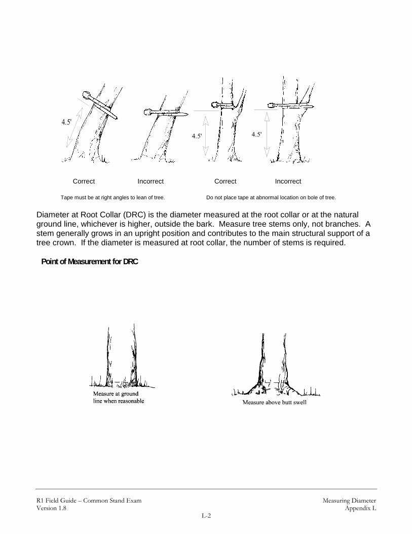
R1 Field Guide – Common Stand Exam Measuring Diameter Version 1.8 Appendix L
L-2
Correct Incorrect Correct Incorrect
Tape must be at right angles to lean of tree. Do not place tape at abnormal location on bole of tree.
Diameter at Root Collar (DRC) is the diameter measured at the root collar or at the natural ground line, whichever is higher, outside the bark. Measure tree stems only, not branches. A stem generally grows in an upright position and contributes to the main structural support of a tree crown. If the diameter is measured at root collar, the number of stems is required.
Point of Measurement for DRC
4.5'
Incorrect
4.5'
Correct
4.5'
Incorrect

R1 Field Guide – Common Stand Exam Measuring Diameter Version 1.8 Appendix L
L-3
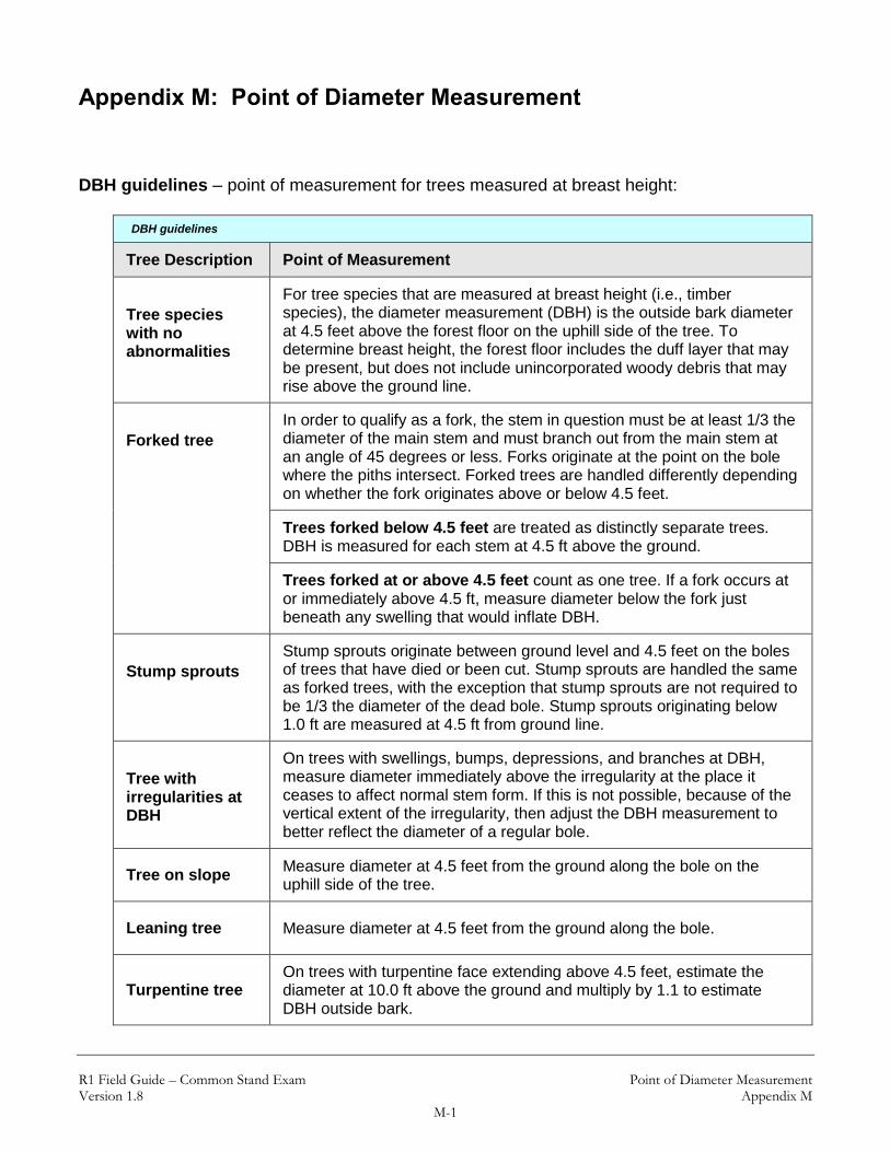
R1 Field Guide – Common Stand Exam Point of Diameter Measurement Version 1.8 Appendix M
M-1
Appendix M: Point of Diameter Measurement DBH guidelines – point of measurement for trees measured at breast height:
DBH guidelines
Tree Description Point of Measurement
Tree species with no abnormalities
For tree species that are measured at breast height (i.e., timber species), the diameter measurement (DBH) is the outside bark diameter at 4.5 feet above the forest floor on the uphill side of the tree. To determine breast height, the forest floor includes the duff layer that may be present, but does not include unincorporated woody debris that may rise above the ground line.
Forked tree
In order to qualify as a fork, the stem in question must be at least 1/3 the diameter of the main stem and must branch out from the main stem at an angle of 45 degrees or less. Forks originate at the point on the bole where the piths intersect. Forked trees are handled differently depending on whether the fork originates above or below 4.5 feet.
Trees forked below 4.5 feet are treated as distinctly separate trees. DBH is measured for each stem at 4.5 ft above the ground.
Trees forked at or above 4.5 feet count as one tree. If a fork occurs at or immediately above 4.5 ft, measure diameter below the fork just beneath any swelling that would inflate DBH.
Stump sprouts
Stump sprouts originate between ground level and 4.5 feet on the boles of trees that have died or been cut. Stump sprouts are handled the same as forked trees, with the exception that stump sprouts are not required to be 1/3 the diameter of the dead bole. Stump sprouts originating below 1.0 ft are measured at 4.5 ft from ground line.
Tree with irregularities at DBH
On trees with swellings, bumps, depressions, and branches at DBH, measure diameter immediately above the irregularity at the place it ceases to affect normal stem form. If this is not possible, because of the vertical extent of the irregularity, then adjust the DBH measurement to better reflect the diameter of a regular bole.
Tree on slope Measure diameter at 4.5 feet from the ground along the bole on the uphill side of the tree.
Leaning tree Measure diameter at 4.5 feet from the ground along the bole.
Turpentine tree On trees with turpentine face extending above 4.5 feet, estimate the diameter at 10.0 ft above the ground and multiply by 1.1 to estimate DBH outside bark.

R1 Field Guide – Common Stand Exam Point of Diameter Measurement Version 1.8 Appendix M
M-2
DBH guidelines
Tree Description Point of Measurement
Independent trees that grow together
If two or more independent stems have grown together at or above the point of DBH, continue to treat them as separate trees.
Dead Tree – missing wood or bark
To qualify as “standing,” dead trees (snags) must have 50% or more of the circumference of the bole intact at DBH, and lean less than 45 degrees from vertical. If a dead tree is missing bark, measure the DBH without the bark and record that measurement.
DRC guidelines – point of measurement for trees measured at root collar:
DRC Guidelines
Tree Description Point of Measurement
Tree species measured at root collar
For tree species that are measured at root collar (Rocky Mountain Juniper, Utah Juniper, and Curl-Leaf Mountain Mahogany), the diameter measurement (DRC) is taken at the root collar or at the point nearest the natural ground line (whichever is higher) that represents the basal area of the tree stem or stems. The place of diameter measurement may vary for trees with stems that are abnormally formed.
Stump sprouts For multi-stemmed woodland species, treat all new sprouts as part of the same new tree.
Minimum Stem Size
Stems must be at least 1.5” dia and one foot in length to be included in the DRC calculation.

R1 Field Guide – Common Stand Exam Point of Diameter Measurement Version 1.8 Appendix M
M-3
Point of Measurement for DBH:
Windthrown tree
4.5'
DBH
Tree on slope
4.5'
DBH
Tree on level ground
Diameter Point
Tree deformed at DBH
4.5'
4.5'
Diameter Point
Tree with branch at 4.5 feet
4.5'
Diameter Point

R1 Field Guide – Common Stand Exam Point of Diameter Measurement Version 1.8 Appendix M
M-4
4.5'Adjust diameter tape to a normally rounded position to allow for the missing catface portion
Tree with a catface
4.5' Make two marks oppositeeach other on the stem at4.5 feet. Measure the distance between the marks with a diamter tape. Double the measurements to determine DBH
4.5'
Crotch
4.5' or higher
DBH
Tree forked at 4.5 feet or higher. Record as one tree and consider only themain fork

R1 Field Guide – Common Stand Exam Radial Growth and Height Growth Version 1.8 Appendix N
N-1
Appendix N: Radial Growth and Height Growth Refer to section A for procedures on measuring radial growth. Refer to section B for procedures on measuring height growth. A. Radial Growth Measurement
The procedures outlined below are for a 10-year radial growth increment measurement:
1. Bore the tree just below the point of diameter measurement, on the side of the tree facing plot center to reduce bias in selecting the radial growth sampling cores. There can be considerable growth difference between the various areas of the same breast height X-section. Slope, aspect, influence from neighboring trees, etc., can affect the width of the growth rings in any given core area.
2. Count back 10 growth rings from the cambium end of the core. 3. Measure the length of this segment of the core to the nearest 1/20th-inch to get radial
increment. Enter this radial increment as the number of twentieths, e.g. 18/20 is recorded "18" and 27/20 is recorded "27."
Steep slopes – It may be difficult or impossible to obtain an increment boring at breast height on very steep slopes when the plot center is downhill from the tree. In this circumstance, obtain the core at breast height on a side of the tree perpendicular to the slope fall line.

R1 Field Guide – Common Stand Exam Radial Growth and Height Growth Version 1.8 Appendix N
N-2
The radial increment growth period is usually 10 years. The measurement is taken from the outside edge of the most current, complete summerwood (denser, dark-colored) ring to the outside edge of the eleventh summerwood ring, so that 10 complete annual increments are included. The last summerwood growth ring is considered complete by September 1 each year.
Example of a 10-year radial growth increment with the first summerwood ring being a complete growth ring.
Example of a 10-year radial growth increment with the first summerwood ring not a complete growth ring.
Use a ruler with a 1/20th-inch scale to measure the radial growth increment.
Plot Center
Slope Fall Line
Perpendicular to Slope
XUphill Side 4.5'
Take boring here

R1 Field Guide – Common Stand Exam Radial Growth and Height Growth Version 1.8 Appendix N
N-3
B. Height Growth Measurement
Five-year height growth is measured on trees less than 3.0 inches DBH. It is measured in feet (to the nearest 0.1 foot). The measurement is taken on the most recent five complete height segments. The current terminal leader is excluded unless subset has occurred. Height increments are recognized by the presence of budscale scars on the nodes (except western redcedar) or by dissecting the leader and counting annual rings with a hand lens.
X
Y
Between lines X and Y is the 5-year Height Increment.
5 Year Height Increment
Current Growth
3 y rs ago
2 y rs ago
1 y r ago
4 y rs ago
5 y rs ago
6 y rs ago
Terminal Bud Scar
No Bud Scar
Terminal Bud Scar

R1 Field Guide – Common Stand Exam Radial Growth and Height Growth Version 1.8 Appendix N
N-4
Height Growth on Trees Taller than 10 Feet:
One crewmember holds up the height pole to the top of the tree. The other crewmember uses binoculars to locate 5 year growth node and read the length on the height pole.

R1 Field Guide – Common Stand Exam Radial Growth and Height Growth Version 1.8 Appendix N
N-5
Using Destructive Sampling: Cut down the tree and measure the 5-year growth.
1. Cut at suspected internode between 5 and 6 years. 2. Cut between suspected internode between 4 and 5 years. 3. Measure at the 5th node.
Note: This graphic illustrates measurement to the top of the tree. If the measurement is taken during the spring or summer, when the tree has a partial years flush of new growth, do NOT include the partial growth. Measure the 5 most recent COMPLETE increments of height growth

R1 Field Guide – Common Stand Exam Measuring Age Version 1.8 Appendix O
O-1
Appendix O: Measuring Age Refer to section A for procedures on measuring age for trees ≥ 3.0 inches DBH. Refer to section B for procedures on measuring age for trees < 3.0 inches DBH. A. Age Measurements for Trees ≥ 3.0-inches DBH
For sample trees 3.0-inches DBH and larger, age is determined from an increment boring made at breast height. The increment boring should be made at breast height facing plot center, to reduce bias. Usually the boring for measuring radial growth is also used for age measurement.
Age is counted from the most current summerwood ring to the pith of the tree. Record the age counted, do not add an estimate of the number of years to grow to breast height.
The ring count is 64 years. Record “64” for Tree Age.
Procedure for Estimating Age:
If a tree is rotten or hollow, or if a tree has a radius greater than the length of the increment borer, use the following procedure:
Bore into the tree as far as possible, extract core and count the rings. Measure the diameter or the tree and divide by two, then subtract the bark thickness. This gives the radius of the wood part of the tree. Measure the length of the core and subtract from the radius of the wood to determine how much longer the core would have to be to reach the pith. Count the number of rings in the inner-most inch and extrapolate to the center.
Note: It is critical to keep increment borers properly sharpened and regularly cleaned. A dull, chipped, or gummed-up increment borer will not take a usable core. Age estimates are only to be used for rotten or hollow trees, or for trees so large that the center cannot be reached. Age estimates are not acceptable due to improper maintenance of increment borers.

R1 Field Guide – Common Stand Exam Measuring Age Version 1.8 Appendix O
O-2
Example (age estimate for large tree):
DBH – 40.0-inches Bark thickness – 2.0 inches Core – 16.0 inches long Ring count – 200 rings, and inner-most inch has 5 rings
Procedure for estimating age:
Step Procedure Measurement or Calculation
1 DBH 40.0 inches
2 Radius of bark and wood (DBH / 2) 40.0 / 2 = 20.0
3 Bark Thickness 2.0 inches
4 Radius of wood (step 2 – step 3) 20.0 – 2.0 = 18.0 inches
5 Core length 16.0 inches
6 Distance short of hitting center:
Radius of wood – core length (step 4 – step 5)
18.0 – 16.0 = 2.0 inches
7 Number of rings (inner-most inch) 5 rings
8 Product (step 6 x step 7) 2 X 5 = 10 rings
9 Ring count (number of rings on core) 200 years
9 Estimated Tree Age: Ring count + product (step 9 + step 8)
200 + 10 = 210 years

R1 Field Guide – Common Stand Exam Measuring Age Version 1.8 Appendix O
O-3
B. Age Measurements for Trees < 3.0-inches DBH
For sample trees less than 3.0-inches DBH, total tree age may be determined by one of the following methods: (1) counting branch whorls that represent annual height increments, (2) severing the tree at the root collar and counting annual rings, or (3) taking an increment boring at the root collar.
1. Counting Branch Whorls
In general, the presence of budscale scars guarantees that the branch whorl represents an annual growth increment. However, as a tree ages, budscale scars become masked by bark development. Be cautious of false branch whorls; these whorls will never have budscale scars at the node, and they sometimes have shorter branches. The total age is recorded in Tree Age. Note: Western redcedar does not have budscale scars and false whorls are common. Therefore, counting branch whorls is never appropriate for cedar.
Current Growth
3 y rs ago
2 y rs ago
1 y r ago
4 y rs ago
5 y rs ago
Terminal Bud Scar
No Bud Scar
Terminal Bud Scar

R1 Field Guide – Common Stand Exam Measuring Age Version 1.8 Appendix O
O-4
1. Cutting Tree at Root Collar to Count Annual Rings
Sample trees can be severed at the root collar in order to count annual rings. The root collar is the transition zone between the stem and the root, and may be recognized by the presence of a slight swelling. The counted age is recorded in Tree Age.
2. Increment Boring at Root Collar
Sample trees can be bored at the root collar to determine age. The same procedures for boring trees at breast height (see above) are used for boring trees at root collar. The counted age is recorded in Tree Age.

R1 Field Guide – Common Stand Exam Measuring Height Version 1.8 Appendix P
P-1
Appendix P: Measuring Height Refer to section A for procedures on measuring total tree height. Section B describes height procedures for leaning trees. Section C describes height procedures for trees with forked, broken, or missing tops. A. Total Tree Height
To determine total tree height, measure from the base of the tree on the high ground side to the tip of the tree leader. Measure height from a point uphill or on the same contour line as the tree. Record total tree height to the nearest foot.
A
B
C
+
_

R1 Field Guide – Common Stand Exam Measuring Height Version 1.8 Appendix P
P-2
B. Height for Leaning Trees
Trees leaning 25% (about 15°) or more from vertical require the following special height measuring technique.
Procedure: Locate point on ground directly under tip of leaning tree. Measure height A B. Measure horizontal distance B C. Determine actual tree height (A C) using either the Pythagorean theory for right triangles where:
Tree Height = 22 BCAB
Example: Measured height (AB) = 120' Horizontal distance (BC) = 40'
Corrected tree height = 2402120 = 126.49
A
B C

R1 Field Guide – Common Stand Exam Measuring Height Version 1.8 Appendix P
P-3
Actual tree height (A C in above diagram) may also be obtained using the following table:
Actual Tree Height (feet)
MS HT
Horizontal Distance - tip to center of bole at ground (B C)
5 10 15 20 25 30 35 40 45 50 55 60 65 70 75 81 85 90
40 40 41 43 45
50 50 51 52 54 56
60 60 61 62 63 65 67
70 71 72 73 74 76 78
80 81 81 82 84 86 87 89
90 91 91 92 94 95 97 98 101
100 101 101 102 103 104 106 108 110 112
110 111 112 113 114 116 117 119 121 123
120 121 122 123 124 125 126 128 130 132 134
130 131 131 132 133 135 136 138 139 141 143 145
140 141 141 142 143 144 146 147 149 150 152 154 157
150 151 151 152 153 154 155 157 158 160 162 164 166 168
160 161 161 162 163 164 165 166 168 169 171 173 175 177 179
170 171 171 172 173 174 175 176 177 179 180 182 184 186 188 190
180 181 181 182 183 183 184 176 187 188 190 191 193 195 197 199 201
190 191 192 192 193 194 195 196 198 200 201 203 204 206 208 210
200 201 202 202 203 204 205 206 208 209 211 212 214 215 217 219
MS HT = (A B) Measured Height

R1 Field Guide – Common Stand Exam Measuring Height Version 1.8 Appendix P
P-4
C. Height for Trees with Forked, Broken, or Missing Tops
Forked Trees If tree forks below DBH, treat as two trees and measure height of each stem from base of tree to tip of tree.
If the fork crotch occurs at or above 4.5 feet on high ground side, the tree is treated as a single tree. Measure height of the tallest fork.
Forked Tree with a Broken Top Measure height of the tallest fork and record in the "Total Height" field. Record a tree damage of “broken top.”
Trees with a Missing Top Measure height of stub and record in the "Total Height" field. Record a tree damage of “missing top.” If the tree is forked, measure the height of the stub of the dominant fork.

R1 Field Guide – Common Stand Exam Measuring Crowns Version 1.8 Appendix Q
Q-1
Appendix Q: Measuring Crowns Height to Live Crown:
Measure the height from the base of the tree on the uphill side (B) to the base (A) of the live crown. Base of the live crown is the lowest branch whorl with live branches in at least two quadrants exclusive of epicormic branching and of whorls not continuous with the main crown.
A
A
A
B B B
A
A
B B B
A

R1 Field Guide – Common Stand Exam Measuring Crowns Version 1.8 Appendix Q
Q-2
Crown Ratio:
Crown ratio is the portion of the tree bole supporting live, healthy foliage and is expressed as a percent of the actual tree height. The distance between A and B is the existing crown length.

R1 Field Guide – Common Stand Exam Damage Categories, Agents, Severity Ratings, and Tree Parts Version 1.8 Appendix R
R-1
Appendix R: Damage Categories, Agents, Severity Ratings, and Tree Parts
Damage Categories:
Damage Categories
Code Description
10 General Insects
11 Bark Beetles
12 Defoliators
13 Chewing Insects
14 Sucking Insects
15 Boring Insects
16 Seed / Cone / Flower / Fruit Insects
17 Gallmaker Insects
18 Insect Predators
19 General Diseases
20 Biotic Damage
21 Root / Butt Diseases
22 Stem Decays / Cankers
23 Parasitic / Epiphytic Plants
24 Decline Complexes / Dieback / Wilts
25 Foliage Diseases
26 Stem Rusts
27 Broom Rusts
30 Fire
41 Wild Animals
42 Domestic Animals
50 Abiotic Damage
60 Competition
70 Human Activities
71 Harvest
80 Multi-damage (insect/disease)
90 Unknown
99 Physical Effects

R1 Field Guide – Common Stand Exam Damage Categories, Agents, Severity Ratings, and Tree Parts Version 1.8 Appendix R
R-2
Damage Categories, Agents, and Severity Ratings:
Damage Categories, Agents, and Severity Ratings
Category 10: General Insects
SEVERITY RATING
1 Minor – tree has reduced growth rate, or some defect associated with product yield.
2 Severe – tree is expected to die within 10 years, or will not yield merchantable sawlog product.
Category Agent Common Name Scientific Name
10 000 General Insects
10 001 Thrips
10 007 Clerid beetle Cleridae
10 009 Green Rose Chafer Dichelonyx backi
10 017 Bagworm moth Psychidae
10 019 Scarab Scarabaeidae
10 021 Steremnius carinatus
10 023 Wood wasps Siricidae spp.
Category 11: Bark Beetles
SEVERITY RATING
1 Unsuccessful bole attack – pitchout and beetle brood absent; pitchouts are recognized by clear or cream colored pitch tubes (globules) on pines and streams of pitch on true firs; no boring dust is present.
2 Strip attacks – galleries and brood present; presence of boring dust and/or reddish-brown colored pitch tubes or streams occurring on less than ¾ of the bole circumference.
3 Successful bole attack – galleries and brood present; boring dust and/or reddish-brown pitch exudations are found on greater than ¾ of the bole circumference.
4 Topkill – the upper portion of the crown fading or dead.
5 Successful attack last year
6 Older dead
Category Agent Common Name Scientific Name
11 000 Bark Beetles
11 001 Roundheaded pine beetle Dendroctonus adjunctus
11 002 Western pine beetle Dendroctonus brevicomis

R1 Field Guide – Common Stand Exam Damage Categories, Agents, Severity Ratings, and Tree Parts Version 1.8 Appendix R
R-3
Damage Categories, Agents, and Severity Ratings
11 005 Lodgepole pine beetle Dendroctonus murrayanae
11 006 Mountain pine beetle Dendroctonus ponderosae
11 007 Douglas-fir beetle Dendroctonus pseudotsugae
11 009 Spruce beetle Dendroctonus rufipennis
11 012 Red turpentine beetle Dendroctonus valens
11 013 Dryocoetes affaber
11 015 Western balsam bark beetle Dryocoetes confusus
11 016 Dryocoetes sechelti
11 017 Ash bark beetles Hylesinus spp.
11 018 Native elm bark beetle Hylurgopinus rufipes
11 021 Sixspined ips Ips calligraphus
11 022 Emarginate ips Ips emarginatus
11 024 Ips latidens
11 026 Monterey pine ips Ips mexicanus
11 028 Northern spruce engraver
beetle Ips perturbatus
11 029 Pine engraver Ips pini
11 030 Ips engraver beetles Ips spp.
11 031 Ips tridens
11 032 Western ash bark beetle Leperisinus californicus
11 034 Orthotomicus caelatus
11 035 Cedar bark beetles Phleosinus spp.
11 036 Western cedar bark beetle Phloeosinus punctatus
11 037 Tip beetles Pityogenes spp.
11 038 Douglas-fir twig beetle Pityophthorus pseudotsugae
11 039 Twig beetles Pityophthorus spp.
11 040 Foureyed spruce beetle Polygraphus rufipennis
11 041 Fir root bark beetle Pseudohylesinum granulatus
11 042 Pseudohylesinus dispar
11 043 Douglas-fir pole beetle Pseudohylesinus nebulosus
11 044 Silver fir beetle Pseudohylesinus sericeus
11 045 Small European elm bark
beetle Scolytus multistriatus
11 046 Spruce engraver Scolytus piceae
11 048 True fir bark beetles Scolytus spp.
11 049 Douglas-fir engraver Scolytus unispinosus
11 050 Fir engraver Scolytus ventralis
11 053 Four-eyed bark beetle Polygraphus spp.
11 054 Hemlock beetle Pseudohylesinus tsugae
Category 12: Defoliators

R1 Field Guide – Common Stand Exam Damage Categories, Agents, Severity Ratings, and Tree Parts Version 1.8 Appendix R
R-4
Damage Categories, Agents, and Severity Ratings
SEVERITY RATING
1 Light Defoliation (1 – 25%) No topkill
2 Light Defoliation (1 – 25%) Topkill ≤ 10 percent
3 Light Defoliation (1 – 25%) Topkill > 10 percent
4 Moderate Defoliation (26 – 75%) No topkill
5 Moderate Defoliation (26 – 75%) Topkill ≤ 10 percent
6 Moderate Defoliation (26 – 75%) Topkill > 10 percent
7 Heavy Defoliation (76 – 100%) No topkill
8 Heavy Defoliation (76 – 100%) Topkill ≤ 10 percent
9 Heavy Defoliation (76 – 100%) Topkill > 10 percent
Category Agent Common Name Scientific Name
12 000 Defoliators
12 001 Casebearer
12 003 Looper
12 005 Sawfly
12 007 Larger elm leaf beetle Monocesta coryli
12 008 Spanworm
12 011 Western blackheaded
budworm Acleris gloverana
12 013 Whitefly Aleyrodoidae
12 014 Fall cankerworm Alsophila pometaria
12 015 Alder flea beetle Altica ambiens
12 016 Mountain mahogany looper Anacamptodes clivinaria profanata
12 018 Oak worms Anisota spp.
12 020 Western larch sawfly Anoplonyx occidens
12 021 Fruit tree leafroller Archips argyrospila
12 022 Uglynest caterpillar Archips cerasivorana
12 023 Boxelder defoliator Archips negundanus
12 030 Pear sawfly Caliroa cerasi
12 033 Boxelder leafroller Caloptilia negundella
12 035 Spruce webspinning sawfly Cephalcia fascipennis
12 036 Two-year budworm Choristoneura biennis
12 037 Large aspen tortrix Choristoneura conflictana
12 039 Sugar pine tortrix Choristoneura lambertiana
12 040 Western spruce budworm Choristoneura occidentalis
12 043 Aspen leaf beetle Chrysomela crotchi
12 044 Cottonwood leaf beetle Chrysomela scripta
12 045 Leafhopper Cicadellidae
12 046 Poplar tentmaker Clostera inclusa

R1 Field Guide – Common Stand Exam Damage Categories, Agents, Severity Ratings, and Tree Parts Version 1.8 Appendix R
R-5
Damage Categories, Agents, and Severity Ratings
12 047 Larch casebearer Coleophora laricella
12 049 Lodgepole needleminer Coleotechnites milleri
12 050 Ponderosa needleminer Coleotechnites spp.
12 051 Black Hills pandora moth Coloradia doris
12 052 Pandora moth Coloradia pandora
12 053 Sycamore lace bug Corythucha ciliata
12 054 Lace bugs Corythucha spp.
12 055 Oak leaftier Croesia semipurpurana
12 058 Yellownecked caterpillar Datana ministra
12 059 Walkingstick Diapheromera femorata
12 060 Spruce coneworm Dioryctria reniculelloides
12 061 Introduced pine sawfly Diprion similis
12 066 White fir needleminer Epinotia meritana
12 071 Elm leafminer Fenusa ulmi
12 072 Geometrid moth Geometridae
12 073 Leafblotch miner Gracillariidae
12 074 Spotted tussock moth Halisidota maculata
12 077 Brown day moth Hemileuca eglanterina
12 082 Fall webworm Hyphantria cunea
12 083 Hemlock looper Lambdina fiscellaria
12 085 Tent caterpillar moth Lasiocampidae
12 086 Satin moth Leucoma salicis
12 087 Willow leafblotch miner Lithocolletis spp.
12 088 Aspen blotchminer Lithocolletis tremuloidiella
12 089 Gypsy moth Lymantria dispar
12 090 Cottonwood leafminers Lyonetia spp.
12 094 Western tent caterpillar Malacosoma californicum
12 096 Forest tent caterpillar Malacosoma disstria
12 098 Leafcutting bees Megachilidae
12 099 Blister beetle Meloidae
12 102 Willow sawfly Nematus spp.
12 104 Lodgepole sawfly Neodiprion burkei
12 106 Pine infesting sawflies Neodiprion fulviceps
12 109 Ponderosa pine sawfly Neodiprion mundus
12 115 Hemlock sawfly Neodiprion tsugae
12 116 Pine butterfly Neophasia menapia
12 117 False hemlock looper Nepytia canosaria
12 118 California tortoiseshell Nymphalis californica
12 120 Bruce spanworm Operophtera bruceata
12 121 Rusty tussock moth Orgyia antiqua
12 122 Whitemarked tussock moth Orgyia leucostigma
12 123 Douglas-fir tussock moth Orgyia pseudotsugata

R1 Field Guide – Common Stand Exam Damage Categories, Agents, Severity Ratings, and Tree Parts Version 1.8 Appendix R
R-6
Damage Categories, Agents, and Severity Ratings
12 124 Western tussock moth Orgyia vetusta
12 125 Spring cankerworm Paleacrita vernata
12 135 Aspen leafminer Phyllocnistis populiella
12 136 Yellowheaded spruce sawfly Pikonema alaskensis
12 137 Tenlined June beetle Polyphylla decemlineata
12 138 Japanese beetle Popillia japonica
12 139 Larch sawfly Pristiphora erichsonii
12 140 Mountain-ash sawfly Pristiphora geniculata
12 141 Elm leaf beetle Pyrrhalta luteola
12 142 Spearmarked black moth Rheumaptera hastata
12 143 Giant silkworm moth Saturniidae
12 144 Redhumped caterpillar Schizura concinna
12 146 Larch looper Semiothisa sexmaculata
12 150 Spruce needleminer (west) Taniva albolineana
12 154 Thyridopteryx ephemeraeformis
12 155 Leafroller/seed moth Tortricidae spp.
12 156 Willow defoliation Tortricidae
12 157 Euonymus caterpillar Yponomeuta spp.
12 159 Larch bud moth Zeiraphera improbana
12 160 Pine needle sheathminer Zelleria haimbachi
12 162 Cottonwood leaf beetle Chrysomela spp.
12 164 Saddle-backed looper Ectropis crepuscularia
12 165 Leaf roller Epinotia solandriana
12 168 Green-striped looper Melanoplophia imitata
12 174 Pine looper Phaeoura mexicanaria
12 176 Zadiprion townsendi
12 177 Douglas-fir budmoth Zeiraphera hesperiana
12 179 Phantom hemlock looper Nepytia phantasmaria
12 180 Tent caterpillar Malacossoma spp.
12 188 Elm sawfly Cimbex americana
12 189 June Beetles / Leaf Chafers Phyllophaga spp.
Category 13: Chewing Insects
SEVERITY RATING
1 Minor – tree has reduced growth rate, or some defect associated with product yield.
2 Severe – tree is expected to die within 10 years, or will not yield merchantable sawlog product.
Category Agent Common Name Scientific Name
13 000 Chewing Insects
13 001 Grasshopper

R1 Field Guide – Common Stand Exam Damage Categories, Agents, Severity Ratings, and Tree Parts Version 1.8 Appendix R
R-7
Damage Categories, Agents, and Severity Ratings
13 002 Shorthorn grasshoppers Acrididae
13 005 Clearwinged grasshopper Camnula pellucida
13 006 Cicadas Cicadidae
13 007 Eurytomids Eurytoma spp.
13 008 Cutworms Euxoa excellens
13 010 Pales weevil Hylobius pales
13 012 Periodical cicada Magicicada septendecim
13 013 Migratory grasshopper Melanoplus sanguinipes
13 014 Valley grasshopper Oedaleonotus enigma
13 015 Strawberry root weevil Otiorhyhchus ovatus
13 020 Northern pitch twig moth Petrova albicapitana
13 021 Ponderosa pine tip moth Rhyacionia zozana
13 022 Pine needle weevil Scythropus spp.
13 025 Thrips madronii
13 026 Ash plant bug Tropidosteptes amoenus
13 028 Pitch-eating weevil Pachylobius picivorus
Category 14: Sucking Insects
SEVERITY RATING
1 Minor – tree has reduced growth rate, or some defect associated with product yield.
2 Severe – tree is expected to die within 10 years, or will not yield merchantable sawlog product.
Category Agent Common Name Scientific Name
14 000 Sucking Insects
14 001 Scale insect
14 002 Western larch wooly aphid Adelges oregonensis
14 003 Balsam woolly adelgid Adelges piceae
14 004 Hemlock woolly adelgid Adelges tsugae
14 006 Aphid Aphididae
14 008 Western pine spittlebug Aphrophora permutata
14 010 Spittlebug Cercopidae
14 012 Pine needle scale Chionaspis pinifoliae
14 014 Giant conifer aphids Cinara spp.
14 017 Spruce aphid Elatobium abietinum
14 018 Wooly apple aphid Erisoma lanigerum
14 022 Pine thrips Gnophothrips spp.
14 026 Lecanium scale Lecanium spp.
14 028 Oystershell scale Lepidosaphes ulmi
14 029 Pinyon needle scale Matsucoccus acalyptus
14 030 Ponderosa pine twig scale Matsucoccus bisetosus

R1 Field Guide – Common Stand Exam Damage Categories, Agents, Severity Ratings, and Tree Parts Version 1.8 Appendix R
R-8
Damage Categories, Agents, and Severity Ratings
14 035 Treehoopers Membracidae
14 039 Black pineleaf scale Nuculaspis californica
14 040 Spruce spider mite Oligonychus ununquis
14 043 Maple aphids Periphyllus spp.
14 044 Spruce bud scale Physokermes piceae
14 046 Pine leaf adelgid Pineus pinifoliae
14 047 White pine adelgid Pineus spp.
14 048 Pine bark adelgid Pineus strobi
14 049 Root aphid Prociphilus americanus
14 050 Mealybug Pseudococcidae
14 051 Cottony maple scale Pulvinaria innumerabilis
14 052 Fir mealybug Puto cupressi
14 061 Pine tortoise scale Toumeyella parvicornis
14 063 Birch aphid Euceraphis betulae
14 068 European elm scale Gossyparia spuria
Category 15: Boring Insects
SEVERITY RATING
1 Minor – tree has reduced growth rate, or some defect associated with product yield.
2 Severe – tree is expected to die within 10 years, or will not yield merchantable sawlog product.
Category Agent Common Name Scientific Name
15 000 Boring Insects
15 001 Shoot borer
15 002 Termite
15 003 Ponderosa pine bark borer Acanthocinus princeps
15 004 Bronze birch borer Agrilus anxius
15 006 Bronze poplar borer Argilus liragus
15 007 Carpenter bees Apidae
15 008 Flatheaded borer Buprestidae
15 009 Golden buprestid Buprestis aurulenta
15 010 Carpenter ants Camponotus spp.
15 011 Gouty pitch midge Cecidomyia piniinopis
15 012 Shootboring sawflies Cephidae
15 013 Roundheaded borer Cerambycidae
15 014 Flatheaded apple tree borer Chrysobothris femorata
15 017 Pitted ambrosia beetle Corthylus punctatissimus
15 018 Carpenterworm moths Cossidae
15 019 Poplar and willow borer Cryptorphynchus lapathi
15 020 Pine reproduction weevil Cylindrocopturus eatoni

R1 Field Guide – Common Stand Exam Damage Categories, Agents, Severity Ratings, and Tree Parts Version 1.8 Appendix R
R-9
Damage Categories, Agents, and Severity Ratings
15 021 Douglas-fir twig weevil Cylindrocopturus furnissi
15 027 Ponderous borer Ergates spiculatus
15 029 Western pine shoot borer Eucosma sonomana
15 030 Eucosma species Eucosma spp.
15 034 Warren's collar weevil Hylobius warreni
15 035 Powderpost beetle Lyctidae
15 036 Tarnished plant bug Lygus lineolaris
15 037 Magdalis spp.
15 038 White pine bark miner Marmara fasciella
15 039 Locust borer Megacyllene robiniae
15 040 California flathead borer Melanophila californica
15 041 Flatheaded fir borer Melanophila drummondi
15 042 Whitespotted sawyer Monochamus scutellatus
15 043 Redheaded ash borer Neoclytus acuminutus
15 045 Oberea shoot borers Oberea spp.
15 048 Pissodes dubius
15 050 White pine weevil Pissodes strobi
15 051 Lodgepole terminal weevil Pissodes terminalis
15 052 Ambrosia beetles Platypus spp.
15 053 Cottonwood borer Plectrodera scalator
15 056 Ash borer Podesesia syringae fraxini
15 057 Lilac borer Podosesia syringae
15 058 Carpenterworm Prionoxystus robiniae
15 059 Maple shoot borers Proterteras spp.
15 060 Western subterranean
termite Reticulitermes hesperus
15 063 European pine shoot moth Rhyacionia buoliana
15 064 Western pine tip moth Rhyacionia bushnelli
15 065 Nantucket pine tip moth Rhyacionia frustrana
15 066 Lodgepole pine tip moth Rhyacionia montana
15 067 Southwestern pine tip moth Rhyacionia neomexicana
15 070 Saperda shoot borer Saperda spp.
15 071 Clearwing moths Sesiidae
15 073 Roundheaded fir borer Tetropium abietis
15 074 Western larch borer Tetropium velutinum
15 075 Western cedar borer Trachykele blondeli
15 076 Douglas-fir pitch moth Vespamima novaroensis
15 077 Sequoia pitch moth Vespamima sequoia
15 083 Ottonwood twig borer Gypsonama haimbachiana
15 085 Banded ash borer Neoclytus capraea

R1 Field Guide – Common Stand Exam Damage Categories, Agents, Severity Ratings, and Tree Parts Version 1.8 Appendix R
R-10
Damage Categories, Agents, and Severity Ratings
Category 16: Seed / Cone / Flower / Fruit Insects
SEVERITY RATING
1 Minor – tree has reduced growth rate, or some defect associated with product yield.
2 Severe – tree is expected to die within 10 years, or will not yield merchantable sawlog product.
Category Agent Common Name Scientific Name
16 000 Seed / Cone / Flower / Fruit
Insects
16 001 Douglas-fir cone moth Barbara colfaxiana
16 002 Lodgepole cone beetle Conophthorus contortae
16 003 Limber pine cone beetle Conophthorus flexilis
16 004 Mountain pine cone beetle Conophthorus monticolae
16 005 Ponderosa pine cone beetle Conophthorus ponderosae
16 010 Douglas-fir cone midge Contarinia oregonensis
16 011 Cone scale midge Contarinia washingtonensis
16 012 Pecan Curculio spp.
16 015 Fir coneworm Dioryctria abietivorella
16 017 Pine coneworm Dioryctria auranticella
16 019 Ponderosa twig moth Dioryctria ponderosae
16 020 Dioryctria pseudotsugella
16 021 Dioryctria moths Dioryctria spp.
16 022 Lodgepole cone moth Eucosma rescissoriana
16 023 Seed chalcid Eurytomidae
16 025 Cone maggot Hylemya anthracina
16 027 Ponderosa pine seed
worm/moth Laspeyresia piperana
16 028 Spruce seed moth Laspeyresia youngana
16 029 Boxelder bug Leptocoris trivittatus
16 031 Western conifer seed bug Leptoglossus occidentalis
16 033 Magastigmus lasiocarpae
16 034 Spruce seed chalcid Magastigmus piceae
16 035 Ponderosa pine seed chalcid Megastigmus albifrons
16 036 Fir seed chalcid Megastigmus pinus
16 037 Douglas-fir seed chalcid Megastigmus spermotrophs
16 040 Roundheaded cone borer Paratimia conicola
16 042 Coneworm Phycitidae
16 043 Harvester ants Pogonomyrmex spp.
16 048 Coneworm Hylemia spp.
16 049 Prairie tent caterpillar Malacosoma lutescens

R1 Field Guide – Common Stand Exam Damage Categories, Agents, Severity Ratings, and Tree Parts Version 1.8 Appendix R
R-11
Damage Categories, Agents, and Severity Ratings
Category 17: Gallmaker Insects
SEVERITY RATING
1 Minor – tree has reduced growth rate, or some defect associated with product yield.
2 Severe – tree is expected to die within 10 years, or will not yield merchantable sawlog product.
Category Agent Common Name Scientific Name
17 000 Gallmaker Insects
17 003 Cooley spruce gall adelgid Adelges cooleyi
17 006 Gall midge Cecidomyiidae
17 007 Douglas-fir needle gall midge Contarinia pseudotsugae
17 008 Gall mite Eriophyidae
17 009 Spruce gall midge Mayetiola piceae
17 013 Gall aphid Phylloxeridae
17 014 Alder gall mite Phytoptus laevis
17 015 Psyllid Psyllidae
17 018 Gouty pitch midge Cedidomyia piniinopsis
17 019 Spider mites Oligonychus spp.
Category 18: Insect Predators
SEVERITY RATING
1 Minor – tree has reduced growth rate, or some defect associated with product yield.
2 Severe – tree is expected to die within 10 years, or will not yield merchantable sawlog product.
Category Agent Common Name Scientific Name
18 000 Insect Predators
18 001 Lacewing
18 002 Blackbellied clerid Enoclerus lecontei
18 003 Redbellied clerid Enoclerus sphegeus
18 005 Western yellowjacket Vespula pennsylvanica
Category 19: General Diseases
SEVERITY RATING
1 Minor – tree has reduced growth rate, or some defect associated with product yield.
2 Severe – tree is expected to die within 10 years, or will not yield merchantable sawlog product.

R1 Field Guide – Common Stand Exam Damage Categories, Agents, Severity Ratings, and Tree Parts Version 1.8 Appendix R
R-12
Damage Categories, Agents, and Severity Ratings
Category Agent Common Name Scientific Name
19 000 General Diseases
Category 20: Biotic Damage
SEVERITY RATING
1 Minor – tree has reduced growth rate, or some defect associated with product yield.
2 Severe – tree is expected to die within 10 years, or will not yield merchantable sawlog product.
Category Agent Common Name Scientific Name
20 000 Biotic Damage
20 001 Damping off
20 002 Gray mold Botrytis cinerea
Category 21: Root / Butt Diseases
SEVERITY RATING
1 Tree Code Tree within 30 feet of other tree with deteriorating crown, other tree with diagnostic symptoms or signs, or other tree killed by root disease
2 Tree Code Pathogen (sign) or diagnostic symptom detected - no crown deterioration
3 Tree Code Crown deterioration detected - no diagnostic symptoms or signs
4 Tree Code Both crown deterioration and diagnostic signs symptoms detected
G0 Setting Code No evidence of RDS within 50 feet of plot
G1 Setting Code RDS present within 50 feet of plot, not on plot
G2 Setting Code Minor evidence of RDS on plot
G3 Setting Code RDS present; canopy reduction < 20%
G4 Setting Code RDS present; canopy reduction 20% to < 30%
G5 Setting Code RDS present; canopy reduction 30% to < 50%
G6 Setting Code RDS present; canopy reduction 50% to < 75%, most ground area infested
G7 Setting Code RDS present; canopy reduction ≥ 75%
G8 Setting Code Entire area infested with RDS; one or very few susceptible overstory trees
G9 Setting Code Entire area infested with RDS; no susceptible overstory trees present
Category Agent Common Name Scientific Name
21 000 Root / Butt Diseases
21 001 Armillaria root disease Armillaria spp.

R1 Field Guide – Common Stand Exam Damage Categories, Agents, Severity Ratings, and Tree Parts Version 1.8 Appendix R
R-13
Damage Categories, Agents, and Severity Ratings
21 004 Brown crumbly rot Fomitopsis pinicola
21 007 White mottled rot Ganoderma applanatum
21 010 Annosus root disease Heterobasidion annosum
21 012 Tomentosus root disease Inonotus tomentosus
21 014 Black stain root disease Ophiostoma wageneri
21 015 Schweinitzii butt rot Phaeolus schweinitzii
21 017 Laminated root rot Phellinus weirii
21 026 Yellow pitted rot Hericium abietis
Category 22: Stem Decays / Cankers
SEVERITY RATING
0 0-4% rotten
Severity codes for Stem Decay and Cankers describe the amount of sawlog volume loss, in terms of cubic feet. For trees smaller than merchantable size, the severity codes are used to record the amount of rotten wood in order to indirectly estimate the sound wood volume yield suitable for pulp or firewood. The percent rotten estimate for these “unmerchantable” trees should thus be made in terms of cubic foot measure. The extent of decay in one-log or smaller trees is estimated directly in cubic foot terms.
1 5-15% rotten
2 16-25% rotten
3 26-35% rotten
4 36-45% rotten
5 46-55% rotten
6 56-65% rotten
7 66-75% rotten
8 76-85% rotten
9 86-100% rotten
Category Agent Common Name Scientific Name
22 000 Stem Decays / Cankers
22 001 Heart rot
22 002 Stem rot
22 003 Sap rot
22 006 Black knot of cherry Apiosporina morbosa
22 007 Atropellis canker Atropellis piniphila
22 012 Black canker of aspen Ceratocystis fimbriata
22 024 Gray-brown saprot Cryptoporus volvatus
22 025 Cryptosphaeria canker of
aspen Cryptosphaeria populina
22 026 Cytospora canker of fir Cytospora abietis
22 027 Western red rot Dichomitus squalens
22 028 Rust-red stringy rot Echinodontium tinctorium
22 029 Sooty-bark canker Encoelia pruinosa
22 035 Amelanchier rust Gymnosporangium harknessianum
22 036 Cedar apple rust Gymnosporangium juniperi-virginianae
22 038 Hypoxylon canker of aspen Hypoxylon mammatum

R1 Field Guide – Common Stand Exam Damage Categories, Agents, Severity Ratings, and Tree Parts Version 1.8 Appendix R
R-14
Damage Categories, Agents, and Severity Ratings
22 040 Sterile conk trunk rot of birch Inonotus obliquus
22 047 Red ring rot Phellinus pini
22 048 Aspen trunk rot Phellinus tremulae
22 051 Phomopsis canker Phomopsis spp.
22 057 Cytospora canker of aspen Cytospora chrysosperma
22 059 Red belt fungus Fomitopsis pinicola
22 062 Brown heartrot Fomitopsis Officinalis
22 063 Coniophora puteana
22 064 Tinder fungus Fomes fomentarius
22 065 Purple conk Hirschioporus abietinus
22 066 Leptographium wagnerii
22 067 Phellinus hartigii
22 068 False tinder fungus Phellinus igniarius
22 070 Yellow cap fungus Pholiota spp.
22 071 Oyster mushroom Pleurotus ostreatus
22 074 Cedar brown pocket rot Poria sericeomollis
22 075 Lanchnellula canker Lachnellula flavoirens
22 077 Phomopsis blight Phomopsis juniperovora
Category 23: Parasitic / Epiphytic Plants
SEVERITY RATING
1 Dwarf Mistletoe Rating Hawksworth tree DMR rating 1
2 Dwarf Mistletoe Rating Hawksworth tree DMR rating 2
3 Dwarf Mistletoe Rating Hawksworth tree DMR rating 3
4 Dwarf Mistletoe Rating Hawksworth tree DMR rating 4
5 Dwarf Mistletoe Rating Hawksworth tree DMR rating 5
6 Dwarf Mistletoe Rating Hawksworth tree DMR rating 6
7 Vine Damage Less than 50% of crown exhibiting vine damage
8 Vine Damage 50% or more of crown exhibiting vine damage
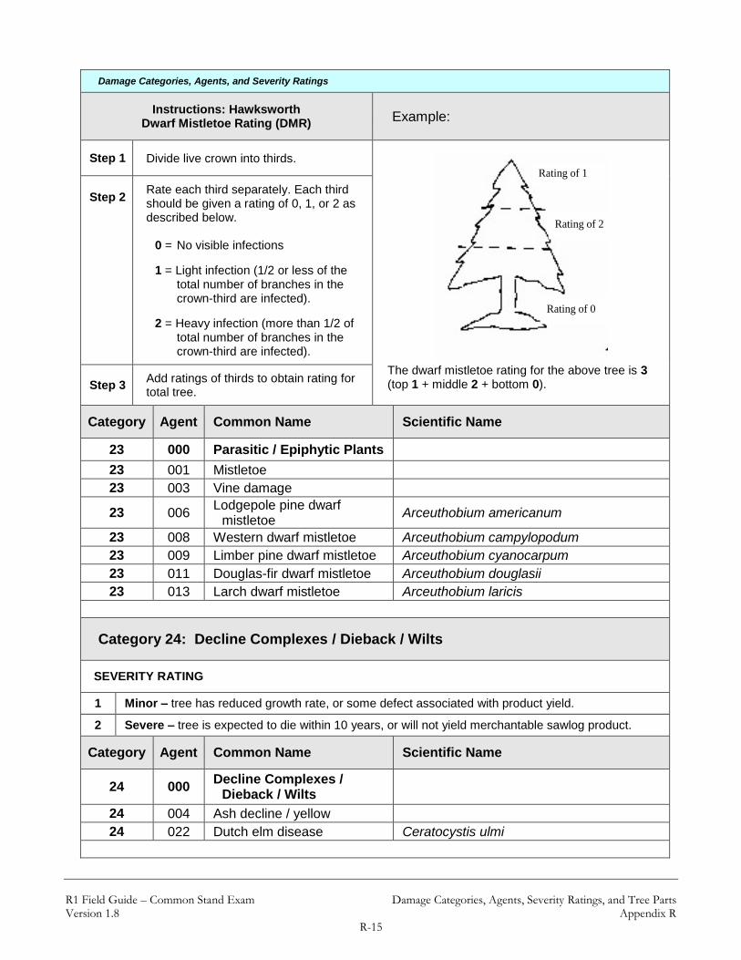
R1 Field Guide – Common Stand Exam Damage Categories, Agents, Severity Ratings, and Tree Parts Version 1.8 Appendix R
R-15
Damage Categories, Agents, and Severity Ratings
Instructions: Hawksworth Dwarf Mistletoe Rating (DMR) Example:
Step 1 Divide live crown into thirds. Rating of 1
Rating of 2
Rating of 0
The dwarf mistletoe rating for the above tree is 3 (top 1 + middle 2 + bottom 0).
Step 2
Rate each third separately. Each third should be given a rating of 0, 1, or 2 as described below.
0 = No visible infections
1 = Light infection (1/2 or less of the total number of branches in the crown-third are infected).
2 = Heavy infection (more than 1/2 of total number of branches in the crown-third are infected).
Step 3 Add ratings of thirds to obtain rating for total tree.
Category Agent Common Name Scientific Name
23 000 Parasitic / Epiphytic Plants
23 001 Mistletoe
23 003 Vine damage
23 006 Lodgepole pine dwarf
mistletoe Arceuthobium americanum
23 008 Western dwarf mistletoe Arceuthobium campylopodum
23 009 Limber pine dwarf mistletoe Arceuthobium cyanocarpum
23 011 Douglas-fir dwarf mistletoe Arceuthobium douglasii
23 013 Larch dwarf mistletoe Arceuthobium laricis
Category 24: Decline Complexes / Dieback / Wilts
SEVERITY RATING
1 Minor – tree has reduced growth rate, or some defect associated with product yield.
2 Severe – tree is expected to die within 10 years, or will not yield merchantable sawlog product.
Category Agent Common Name Scientific Name
24 000 Decline Complexes /
Dieback / Wilts
24 004 Ash decline / yellow
24 022 Dutch elm disease Ceratocystis ulmi

R1 Field Guide – Common Stand Exam Damage Categories, Agents, Severity Ratings, and Tree Parts Version 1.8 Appendix R
R-16
Damage Categories, Agents, and Severity Ratings
Category 25: Foliage Diseases
SEVERITY RATING
1 Minor – tree has reduced growth rate, or some defect associated with product yield.
2 Severe – tree is expected to die within 10 years, or will not yield merchantable sawlog product.
Category Agent Common Name Scientific Name
25 000 Foliage Diseases
25 001 Blight
25 002 Broom rust
25 003 Juniper blights
25 004 Leaf spots
25 005 Needlecast
25 006 Powdery mildew
25 009 True fir needlecast
25 013 Large-pored spruce-
laborador tea rust Chrysomyxa ledicola
25 014 Ink spot of aspen Ciborinia whetzelii
25 015 Pine needle rust Coleosporium spp.
25 019 Cedar leaf blight Didymascella thujina
25 020 Dogwood anthracnose Discula spp.
25 022 Elytroderma disease Elytroderma deformans
25 023 Fire blight Erwinia amylovora
25 027 Brown felt blight Herpotrichia juniperi
25 028 Larch needle blight Hypodermella laricis
25 031 Spruce needle cast Lirula macrospora
25 032 Fir needle cast Lirula spp.
25 033 White pine needle cast Lophodermella arcuata
25 034 Lophodermella needle cast Lophodermella spp.
25 035 Lophodermium needle cast Lophodermium spp.
25 036 Marssonina blight Marssonina populi
25 037 Melampsora rusts Melampsora medusae
25 039 Larch needle cast Meria laricis
25 040 Dothistroma needle blight Mycosphaerella pini
25 041 Brown felt blight of pines Neopeckia coulteri
25 042 Snow blight Phacidum abietis
25 043 Swiss needle cast Phaeocryptopus gaumannii
25 049 Fir needle rust Pucciniastrum spp.
25 050 Douglas-fir needle cast Rhabdocline spp.
25 052 Rhizophaeria needle cast Rhizophaeria spp.
25 054 Brown spot needle blight Scirrhia acicola

R1 Field Guide – Common Stand Exam Damage Categories, Agents, Severity Ratings, and Tree Parts Version 1.8 Appendix R
R-17
Damage Categories, Agents, and Severity Ratings
25 056 Septoria leaf spot and canker Septoria musiva
25 058 Diplodia blight Sphaeropsis sapinea
25 061 Shepherd's crook Venturia tremulae
25 062 Dothistroma needle blight Dothistroma septospora
25 064 Broom rust Chrysomyxa arctostaphyli
25 065 Spruce needle rust Chrysomyxa weirii
25 067 Spruce needle cast Lophodermium picea
25 068 Hardwood leaf rusts Melampsora spp.
25 072 Sirococcus shoot blight Sirococcus strobilinus
25 073 Shepherds crook Venturia populina
25 074 Delphinella shoot blight Delphinella abietis
Category 26: Stem Rusts
SEVERITY RATING
1 Branch infections located greater than 2 feet from tree bole
2 Branch infections located between 6 inches and 2 feet from tree bole
3 Bole infections or branch infections located within 6 inches of bole
4 Topkill
Category Agent Common Name Scientific Name
26 000 Stem Rusts
26 001 White pine blister rust Cronartium ribicola
26 002 Western gall rust Peridermium harknessii
26 003 Stalactiform blister rust Cronartium coleosporioides
26 004 Comandra blister rust Cronartium comandrae
26 011 Bethuli rust Peridermium bethuli
Category 27: Broom Rusts
SEVERITY RATING
1 Minor – tree has reduced growth rate, or some defect associated with product yield.
2 Severe – tree is expected to die within 10 years, or will not yield merchantable sawlog product.
Category Agent Common Name Scientific Name
27 000 Broom Rusts
27 001 Spruce broom rust Chrysomyxa arctostaphyli
27 003 Juniper broom rust Gymnosporangium nidus-avis
27 004 Fir broom rust Melampsorella caryophyllacearum

R1 Field Guide – Common Stand Exam Damage Categories, Agents, Severity Ratings, and Tree Parts Version 1.8 Appendix R
R-18
Damage Categories, Agents, and Severity Ratings
Category 30: Fire
SEVERITY RATING
1 Minor – tree has reduced growth rate, or some defect associated with product yield.
2 Severe – tree is expected to die within 10 years, or will not yield merchantable sawlog product.
Category Agent Name
30 000 Fire
30 031 Wildfire
30 032 Human caused fire
30 033 Crown fire damage
30 034 Ground fire damage
Category 41: Wild Animals
SEVERITY RATING
1 Minor – tree has reduced growth rate, or some defect associated with product yield.
2 Severe – tree is expected to die within 10 years, or will not yield merchantable sawlog product.
Category Agent Name
41 000 Wild Animals
41 001 Bear
41 002 Beaver
41 003 Big game (deer) use if you can identiy to 011, 012, or 013
41 004 Mice or voles
41 005 Pocket gophers
41 006 Porcupines
41 007 Rabbits or hares
41 008 Sapsucker
41 009 Squirrels
41 010 Woodpeckers
41 011 Moose
41 012 Elk
41 013 Deer
41 014 Feral pigs
41 015 Mountain beaver
Category 42: Domestic Animals
R1 Field Guide – Common Stand Exam Damage Categories, Agents, Severity Ratings, and Tree Parts Version 1.8 Appendix R
R-19
Damage Categories, Agents, and Severity Ratings
SEVERITY RATING
1 Minor – tree has reduced growth rate, or some defect associated with product yield.
2 Severe – tree is expected to die within 10 years, or will not yield merchantable sawlog product.
Category Agent Name
42 000 Domestic Animals
42 001 Cattle
42 002 Goats
42 003 Horses
42 004 Sheep
Category 50: Abiotic Damage
SEVERITY RATING
1 Minor – tree has reduced growth rate, or some defect associated with product yield.
2 Severe – tree is expected to die within 10 years, or will not yield merchantable sawlog product.
Category Agent Name
50 000 Abiotic Damage
50 001 Air pollutants
50 002 Chemical
50 003 Drought
50 004 Flooding/high water
50 005 Frost
50 006 Hail
50 007 Heat
50 008 Lightning
50 009 Nutrient imbalances
50 010 Radiation
50 011 Snow/ice
50 013 Wind/tornado
50 014 Winter injury
50 015 Avalanche
50 016 Mud/land slide
50 018 Other geologic event
50 019 Mechanical (non-human caused)

R1 Field Guide – Common Stand Exam Damage Categories, Agents, Severity Ratings, and Tree Parts Version 1.8 Appendix R
R-20
Damage Categories, Agents, and Severity Ratings
Category 60: Competition
SEVERITY RATING
1 Minor – tree has reduced growth rate, or some defect associated with product yield.
2 Severe – tree is expected to die within 10 years, or will not yield merchantable sawlog product.
Category Agent Name
60 000 Competition
Category 70: Human Activities
SEVERITY RATING
1 Minor – tree has reduced growth rate, or some defect associated with product yield.
2 Severe – tree is expected to die within 10 years, or will not yield merchantable sawlog product.
Category Agent Name
70 000 Human Activities
70 001 Herbicides
70 003 Imbedded objects
70 004 Improper planting technique
70 005 Land clearing
70 006 Land use conversion
70 007 Logging damage
70 008 Mechanical
70 009 Pesticides
70 010 Roads
70 011 Soil compaction
70 012 Suppression
70 013 Vehicle damage
70 014 Road salt
Category 71: Harvest
SEVERITY RATING
1 Minor – tree has reduced growth rate, or some defect associated with product yield.
2 Severe – tree is expected to die within 10 years, or will not yield merchantable sawlog product.

R1 Field Guide – Common Stand Exam Damage Categories, Agents, Severity Ratings, and Tree Parts Version 1.8 Appendix R
R-21
Damage Categories, Agents, and Severity Ratings
Category Agent Name
71 000 Harvest
Category 80: Multi-damage (insect/disease)
SEVERITY RATING
1 Minor – tree has some reduced growth rate, or some defect associeated with product yield
2 Severe – tree is expected to die within 10 years, or will not yield merchantable sawlog product.
Category Agent Name
80 000 Multi-damage (insect/disease)
80 001 Aspen defoliation
12037 = Defoliator/ large aspen tortrix
12096 = Defoliator/ forest tent caterpillar
25036 = Foliage disease/ Marssonina blight
25037 = Foliage disease/ Melampsora rusts
80
002
Subalpine fir mortality
11015 = Bark beetles/ Western balsam bark beetle
21001 = Root/butt disease/ armillaria root disease
21010 = Root/butt disease/ annosus root disease
50014 = Abiotic damage/ winter injury
Category 90: Unknown
SEVERITY RATING
0 0 – 9% affected
1 10 – 19% affected
2 20 – 29% affected
3 30 – 39% affected
4 40 – 49% affected
5 50 – 59% affected
6 60 – 69% affected
7 70 – 79% affected
8 80 – 89% affected
9 90 – 100% affected
Category Agent Name
90 000 Unknown
Category 99: Physical Effects

R1 Field Guide – Common Stand Exam Damage Categories, Agents, Severity Ratings, and Tree Parts Version 1.8 Appendix R
R-22
Damage Categories, Agents, and Severity Ratings
Category Agent Physical Effects
Severity Rating Note: for items that do not have a severity code listed below, record the percent of the tree area affected (eg.,
percent of height, percent of bole, percent of volume) as specified.
99 001
Broken or missing top
Record for all species when the break occurs at or above 4.5 feet, for hardwoods, record when the break occurs on the main stem.
Percent of original height that is missing
For example, if a tree was originally 75 feet high, but 15 feet of the top is broken or missing, enter “20” for the severity code (15/75 = 20%).
99 002
Dead top
Record for all trees with a dead terminal leader.
Percent of total tree height that is dead
99 003 Limby
Large limbs top to bottom
Percent of total tree height with many limbs/knots
99 004
Forked top
For trees ≥ 5.0-inches DBH, fork must be below 4.0-inch diameter top. Do not record for hardwoods.
Percent of total tree height above fork
99 006 Crook or sweep Percent of total tree height containing
thecrook or sweep
99 007 Checks, bole cracks Percent of bole affected
99 008 Foliage discoloration Percent of foliage discolored
99 009 Mortality Use for R1 Intensified FIA grid plots only
99 010 Lack of seed source
For plantation surveys only If present, code 100%
99 011 Poor planting stock
For plantation surveys only If present, code 100%
99 012 Poor growth 1 = minor (reduced growth)
2 = severe (affecting survival)
99 013 Total board foot volume loss
Percent of total board foot volume loss
(only examine the merchantable portion of the tree)
99 014 Total cubic foot volume loss
Percent of total cubic foot volume loss
(only examine the merchantable portion of the tree)
99 015 Bark removal Percent of tree circumference missing bark

R1 Field Guide – Common Stand Exam Damage Categories, Agents, Severity Ratings, and Tree Parts Version 1.8 Appendix R
R-23
Damage Categories, Agents, and Severity Ratings
99 016 Foliage loss 1 = minor (reduced growth)
2 = severe (affecting survival)
99 017 Sunscald 1 = minor (reduced growth)
2 = severe (affecting survival)
99 018 Uproot NA
99 019 Scorched foliage % of total crown foliage killed by fire
99 020 Scorched bark % of tree circumfrance that has cambium killed
by fire
99 021 Dieback
For plantation surveys only
1 = minor (reduced growth)
2 = severe (affecting survival)
99 022 Poor crown form 1 = minor (reduced growth)
2 = severe (affecting survival)
99 023 Severe forking NA
99 026 Open wound
Percent of bole/trunk affected
Examine the height and width of the wound.
For example, if a tree is 72 feet tall and the wound covers 12 feet of the bole, enter a value of “16” (12/72 = 16%).
99 033 Damaged shoots, buds, or
foliage
1 = minor
2 = severe
99 036 Fire scar
Percent of bole/trunk affected
Examine the height and width of the wound.
For example, if a tree is 72 feet tall and the wound covers 12 feet of the bole, enter a value of “16” (12/72 = 16%).
99 037 Self-supporting Leaning Tree
Lean angle > 15% Percent lean from vertical

R1 Field Guide – Common Stand Exam Damage Categories, Agents, Severity Ratings, and Tree Parts Version 1.8 Appendix R
R-24
Tree Damage Parts:
Tree Damage Parts
Code Description
UN Unspecified
TO Top
FO Foliar (Crown)
LI Limb
BO Bole, other than Top or Base
BA Base
RO Roots
WT Whole Tree
TT Top Third of Crown
MT Middle Third of Crown
BT Bottom Third of Crown

R1 Field Guide – Common Stand Exam Down-Woody Materials Version 1.8 Appendix S
S-1
Appendix S: Down-Woody Materials There are two recommended methods to inventory dead, down-woody debris:
Photo Series Method – the Photo Series for Quantifying Forest Residues. This method is an estimation technique. The actual data contained in the Photo series tables were obtained by sampling the photo plots using the Planar Intercept method
Brown’s Protocol Method – the Planar Intercept Method referenced in the Handbook for Inventorying Down, Woody Material by James K. Brown (1974). This method uses data measurements that are accurate to a specific statistical reliability.
Each method requires a different level of training, and the amount of time and expense needed for data collection varies. These methods are described in further detail below.
Photo Series Method
This method involves making visual comparisons between the on-site fuel condition and the conditions depicted on the photos. The Photo Series is intended to allow fast, easy and inexpensive quantifications of forest residues. Before using a particular Photo Series, become thoroughly familiar with the photo series book. To best understand how the photo series works, conduct several samples utilizing James K. Brown’s Handbook for Inventorying Downed Woody Material. Actual “hands on” sampling using the Brown method provides the ability to fine-tune ocular estimates. The photo series relies heavily on the estimator’s ability to visually compare actual on-the-ground conditions to characteristics on representative photos.
Sampling Procedures Enter the weight (tons/acre) and volume (MBF/acre) by size class by selecting the representative photo based on the instructions found within the photo series. Compare photos to best match the ground conditions being evaluated. Only the dead and down-woody material (twigs, stems, branches, and bolewood) from trees and shrubs is evaluated. Do not allow the live species in the sample area to skew the visual estimate. Since the photo series requires an interpolation of photos to actual conditions, it is helpful to begin by estimating mid-size fuels first before moving to the finer fuels.

R1 Field Guide – Common Stand Exam Down-Woody Materials Version 1.8 Appendix S
S-2
Brown’s Protocol Method
Sampling Procedures For average amounts of downed debris, about 5 to 6 minutes per sample point is required for the measurements. More time is usually spent in traveling and locating sample points than in making the measurements. If only down-woody material is inventoried, a two-person crew can complete 2O to 4O plots a day, depending on how much debris is present.
The Sampling Planes The inventory is based on the planar intersect technique (1),(2) which has the same theoretical basis as the line intersect technique (3). The planar intersect technique involves counting intersections of woody pieces with vertical sampling planes that resemble guillotines dropped through the downed debris.
Sampling Plane Height The sampling plane height (vertical height) is undefined so that all intersections of dead down material are tallied regardless of their height above the ground. Tree boles are considered down if they lean greater than 45 degrees from the perpendicular. Sampling plane lengths vary by size and amount of down-woody material.
Sampling Plane Length Length of sampling plane can be varied by users to obtain desired sampling precision. Generally, as fewer sample points are taken, sampling plane lengths should be longer to achieve desired sampling precision. Sampling plane lengths are horizontal lengths. Slope distance will need to be adjusted to a horizontal distance. If a sampling plane extends beyond the border of the stand, truncate the plane at the stand boundary and project the remaining length along the reverse azimuth from the point center.
--------------------------
(1) Brown, James K. 1974. Handbook for inventorying downed woody material. USDA For. Serv. Gen. Tech. Rep.
INT-16, 24 p. Intermt. For. and Range Exp. Stn., Ogden, Utah. (2) Brown, James K., and Peter J. Roussopoulos. 1974. Eliminating biases in the planner intersect method for
estimating volumes of small fuels. For. Sci. 20(4): 350-356. (3) Van Wagner, C. E. 1968. The line intersect method in forest fuel sampling. For. Sci. 14(1): 20-26.

R1 Field Guide – Common Stand Exam Down-Woody Materials Version 1.8 Appendix S
S-3
The table that follows suggests sampling plane lengths and number of sample points needed to obtain specified percent errors (standard error of estimate divided by the mean, expressed as percentage). These recommendations are based on average distributions of naturally fallen down-woody material sampled in the northern Rocky Mountains (4). The sampling plane lengths can be expected to vary from one-half of the table values, for heavy fuels that are uniformly distributed, to twice the table values, for light and unevenly distributed fuels. For heavy slash, the sampling plane lengths recommended for naturally fallen fuels could be cut in half. A standard error of estimate within 20 percent of the mean is often considered adequate for fuel appraisal. A smaller percent error may be desirable for planning utilization of down-woody material. Percent errors greater than 35 percent afford poor reliability. If sampling cannot provide at least this level of reliability, it may not be worthwhile. Fuel Estimate Decide whether an estimate of fuels is needed for an individual stand or for several stands together. If fuel quantities are believed to be similar in several stands, then a single estimate is appropriate for appraising fuels in these stands. This is often the case for several adjacent stands in a timber sale area. If fuel estimates are desired for individual stands, then choose a sampling plane length appropriate for the number of sample points planned for the stand. The same sampling plane length should be used throughout each stand or group of stands for which fuel estimates are sought.
--------------------------
(4) Brown, James K., Rick D. Oberheu, and Cameron M. Johnston. 1982 Handbook for Inventorying surface fuels
and biomass in the Interior West. USDA For. Serv. Gen. Tech. Rep. Int-129, 48 p. Intermt. For. and Range Exp. Stn., Ogden, Utah

R1 Field Guide – Common Stand Exam Down-Woody Materials Version 1.8 Appendix S
S-4
Length of Sampling Plane for Percent Errors and Number of Sample Points
Diameter Class Range
Percent Error
Number of Sample Points
5 6 7 8 10 15 20 30
Sampling Plane Lengths in Feet
0.1 - 1 inch
15 34 28 24 21 17 11 8 6
20 19 16 14 12 10 6 5 4
25 12 10 9 8 6 4 3 2
30 8 7 6 5 4 3 2 2
35 6 5 5 4 3 2 2 1
1 - 3
inches
15 85 70 60 55 45 30 22 14
20 50 40 35 30 24 16 12 8
25 30 25 22 20 16 10 8 5
30 22 18 15 14 11 7 5 4
35 16 13 11 10 8 5 4 3
3+
inches
15 380 315 270 235 190 125 95 65
20 210 175 150 130 105 70 50 35
25 140 115 100 90 70 50 35 25
30 100 80 70 60 50 35 25 15
35 70 60 50 45 35 25 18 12
Record each Sampling Plane Length once per sample stand (on the Sample Design form). For example, if number of sample points is 20 and desired percent of error is 20%, then record:
05 for the 0.1- to 1-inch diameter class range
12 for the 1- to 3-inch diameter class range
50 for the ≥ 3-inch diameter class range

R1 Field Guide – Common Stand Exam Down-Woody Materials Version 1.8 Appendix S
S-5
In medium fuel situations, these sampling planes should provide percent errors of about 20 percent with 20 sample points, and 30 percent with 10 sample points. Unless users specify sampling plane lengths on the field record, the following lengths should be used and are assumed (defaults) in the computer programs:
Defaults:
Fuel Diameter Sampling
Plane Length
3 + inches 27 feet
1 – 3 inches 7 feet
0.1 – 1 inch 7 feet

R1 Field Guide – Common Stand Exam Down-Woody Materials Version 1.8 Appendix S
S-6
Tally Rules for the Downed Fuel Inventory
1. Particles qualifying for tally include downed, dead woody material (twigs, stems, branches, and bolewood) from trees and shrubs. Dead branches attached to boles of standing trees are omitted because they are not downed vegetation. Consider a particle “downed” if it has fallen to the ground, or is severed from its original source of growth. Cones, bark flakes, needles, leaves, grass, and forbs are not counted. Dead woody stems and branches still attached to standing brush and trees are not counted.
2. Twigs or branches lying in the litter layer and above are counted. However, they are not
counted when the intersection between the central axis of the particle and the sampling plane lies in the duff (forest floor below the litter).
3. If the sampling plane intersects the end of a piece, tally only if the central axis is
crossed. If the plane exactly intersects the central axis, tally every other such piece.
4. Don't tally any particle having a central axis that coincides perfectly with the sampling plane.
5. If the sampling plane intersects a curved piece more than once, tally each intersection.
6. Tally wood slivers and chunks left after logging. Visually mold these pieces into
cylinders to determine size class or diameters.
7. Tally uprooted stumps and roots not encased in dirt. For tallying, consider uprooted stumps as tree boles or individual roots, depending on where the sampling planes intersect the stumps. Do not tally undisturbed stumps.
8. Tally all intersections of dead tree boles which lean greater than 45 degrees from the
perpendicular regardless of the height of these intersections. Do not tally intersections of any standing dead trees which do not lean greater than 45 degrees from the perpendicular even if the point of intersection is within 6 feet of the ground.

R1 Field Guide – Common Stand Exam Down-Woody Materials Version 1.8 Appendix S
S-7
Explanatory Figures
1. When stumps, logs, and trees occur at the point of duff measurement, offset 1 foot
perpendicular to the right of the sampling plane. Measure through rotten logs whose central axis is in the duff layer.
2. Twigs or branches lying in the litter layer and above are counted. However, they are not counted when the intersection between the central axis of the particle and the sampling plane lies in the duff (forest floor below the litter).

R1 Field Guide – Common Stand Exam Down-Woody Materials Version 1.8 Appendix S
S-8
3. If the sampling plane intersects the end of a piece, tally only if the central axis is crossed. If the plane exactly intersects the central axis, tally every other such piece.
4. If the sampling plane intersects a curved piece more than once, tally each intersection.
CenterTop
Sampling Planes
In
Out
Intersections
Sampling Plane

R1 Field Guide – Common Stand Exam Down-Woody Materials Version 1.8 Appendix S
S-9
Determining Tally Pieces on a Fixed Area Plot If collecting down-woody information on a fixed-area plot, the piece is tallied if the point on the upper most surface of the cylinder, mid-length of the piece, is within the fixed-area plot. To determine the midpoint of a piece, measure the length, in feet, and divide by 2.
Midpoint is the uppermost point at the mid-length of the piece.
Position of midpoint of piece on the plot determines tally.
IN
fixed plot
OUT
IN

R1 Field Guide – Common Stand Exam Down-Woody Materials Version 1.8 Appendix S
S-10
A down log may be broken into more than one piece. If a log is cracked, broken, or partially cut, but the two parts are still physically touching, then consider the log to be one piece.
Midpoint on a one piece log.
However, if the two or more parts are not physically touching, then consider the parts to be separate pieces, each having their own midpoint. This may affect whether all parts of the down log are within the fixed-radius plot.
Broken pieces not touching are measured separately.
(continued on next page)
midpoint
3 pieces, 3 midpoints

R1 Field Guide – Common Stand Exam Down-Woody Materials Version 1.8 Appendix S
S-11
Broken pieces have separate midpoints; this can affect which pieces are tallied.
IN
fixed plot
OUT

R1 Field Guide – Common Stand Exam Glossary of Terms Version 1.8 Appendix T
T-1
Appendix T: Tolerances for Region 1 Common Stand Exam Item Numbers listed are in reference to the Region 1 CSE Field Guide.
Setting Form – Intensive/Extensive Exam Levels:
Setting Form – Intensive/Extensive Exam Levels
Item No. Field Name Tolerance
2.1 Project Name No Errors
2.2 Proclaimed Region No Errors
2.3 Proclaimed National Forest No Errors
2.4 District No Errors
2.5 Location No Errors
2.6 Stand Number No Errors
2.7 Owner No Errors
2.8 State No Errors
2.9 County No Errors
2.10 Administrative Forest No Errors
2.11 Date No Errors
2.12 Photo ID No Errors
2.13 Examination Level No Errors
2.14 Exam Purpose No Errors
2.15 Stratum No Errors
2.16 Existing Vegetation Reference No Errors
2.17 Existing Vegetation Composition Type No Errors
2.18 Potential Vegetation Reference No Errors
2.19 Potential Vegetation No Errors
2.20 Structure No Errors
2.21 Setting Capable Growing Area ± 10 percent
2.22 Setting Fuel Model No Errors
2.23 Setting Elevation ± 2 contour intervals
2.24 Setting Aspect ± 45 degrees
2.25 Setting Slope ± 10 percent
2.26 Setting Slope Position ± 1 class

R1 Field Guide – Common Stand Exam Glossary of Terms Version 1.8 Appendix T
T-2
Setting Form – Intensive/Extensive Exam Levels
Item No. Field Name Tolerance
2.27 Acres No Errors
2.28 Examiner No Errors
2.29 Precision Protocol No Errors
2.30 Radial Growth Interval No Errors
2.31 Radial Growth Interval 2
(NOT used in Region 1) ---
2.32 Height Growth Interval No Errors
2.33 Fuel Photo Reference No Errors
2.34 Setting User Code No Errors
2.35 Setting Remarks No Errors
2.36
Setting Damage Category
(if found along transect and not in
Tree Damage or Plot History)
No Errors
2.37 Setting Damage Agent Locally specified
2.38 Setting Damage Severity Locally specified
2.39 Species of Management Interest No Errors
2.40 Sketch Map and Traverse Notes
Sample Design Form – All Exam Levels:
Sample Design Form – All Exam Levels
Item No. Field Name Tolerance
3.1 Form Type
3.2 Sample Selection Method Type No Errors
3.3 Sample Expansion Factor No Errors
3.4 Starting Azimuth No Errors
3.5 Subpopulation Filter No Errors
3.6 Sample Design Remarks No Errors
3.7 Selection Criteria Number or
Criteria Condition No Errors
3.8 Subpopulation Variable No Errors
3.9 Subpopulation Minimum Value No Errors
3.10 Subpopulation Maximum Value No Errors

R1 Field Guide – Common Stand Exam Glossary of Terms Version 1.8 Appendix T
T-3
Plot Data Form – All Exam Levels:
Plot Data Form – All Exam Levels
Item No. Field Name Tolerance
4.1 Plot Number No Errors
4.2
Acquiring GPS Locations:
Plot Latitude Estimated Horizontal Distance:
± 15 meters (49.2 feet)
Position Error: ± 15 meters (49.2 feet) 85% of the time
Plot Longitude
4.3 Plot Capable Grow Area No Errors
4.4 Plot Aspect ± 45 degrees
4.5 Plot Slope ± 10 percent
4.6 Plot Slope Position ± 1 class
4.7 Slope Horizontal Shape No Errors
4.8 Slope Vertical Shape No Errors
4.9 Plot Elevation ± 100 feet (GPS Method)
± 2 contour intervals (from provided maps)
4.10 Plot Existing Vegetation
Composition Type No Errors
4.11 Plot Potential Vegetation Accurate to series, understory union, and
Forest/District specified phases
4.12 Plot Fuel Model No Errors
4.13 Residual Descriptive Code
(Fuel Photo Series) No Errors
4.14 Distance to Seed Wall ± 100 feet
4.15 Plot User Code No Errors
4.16 Plot History No Errors
4.17 Plot History Date No Errors
4.18 Plot Remarks

R1 Field Guide – Common Stand Exam Glossary of Terms Version 1.8 Appendix T
T-4
Tree Data Form – Intensive Exam Level:
Tree Data Form – Intensive Exam Level
Item No. Field Name Tolerance
5.1 Plot Number No Errors
5.2 Tag ID Number No Errors
5.3 Tree Status No Errors
5.4
Tree Class
Tree Class Code Tolerance DE DE, AC AC DE, AC, UA UA AC, UA, RF* RF RF, UA* RN RN, UA* SV SV, US US SV, US
* acceptable code providing damage/severity
is consistent with the TREE CLASS definition.
5.5 Growth Sample (GST)
/ Site Trees No Errors
5.6 Tree Species No Errors
5.7
Tree Count
Number of Trees Diameter Height or Mixed/Extra on Plot (DBH/DRC) Height Class Tree Tolerance
0 NA NA No Errors
1 - 5 -- ≤ 0.5 feet ± 2 trees
6+ -- ≤ 0.5 feet ± 50%
1 - 5 < 0.5 inches > 0.5 feet ± 1 tree
6+ < 0.5 inches > 0.5 feet ± 20%
1 - 5 0.5 in - All ± 1 tree Breakpoint DBH
6+ 0.5 in - All ± 10% Breakpoint DBH
1+ Breakpoint DBH+ All No Errors
5.8
Number Stems
(used only for
EXAM PURPOSE ‘FI’)
No Errors

R1 Field Guide – Common Stand Exam Glossary of Terms Version 1.8 Appendix T
T-5
Tree Data Form – Intensive Exam Level
Item No. Field Name Tolerance
5.9
DBH/DRC
DBH (range): < 0.5 inch No Errors 0.5 – 13.9 inches ± 0.1 inch 14.0 – 23.9 inches ± 0.2 inch 24.0 – 34.9 inches ± 0.3 inch 35.0+ inches ± 0.5 inch Borderline variable-plot trees ± 0.1 inch
(to determine trees in or out)
5.10 Height ± 10 percent of actual standing tree height
5.11 Height to Crown ± 10 percent of actual crown height
5.12 Radial Growth ± 1/20th inch
5.13 Radial Growth #2
(NOT used in Region 1) ---
5.14 Height Growth trees ≥ 6 feet: ± 1 foot trees < 6 feet: ± 0.1 foot
5.15 Tree Age trees < 300 years old: ± 10 percent trees ≥ 300 years old: ± 15 percent
5.16 Crown Ratio ± 10 percent
5.17 Crown Class ± 1 class
5.18 Crown Width ± 10 percent
5.19 Wildlife Use No Errors
5.20 Snag Decay Class ± 1 class
5.21 Cone Serotiny No Errors
5.22 Tree Damage Category No Errors (unless otherwise specified) Refer to Damage Category Table below
5.23 Tree Damage Agent (see Damage Category)
5.24 Tree Damage Part No Errors (when required)
5.25 Tree Damage Severity (see Damage Category)
5.26
Tree Remarks (additional items):
Estimated Age Recorded when applicable

R1 Field Guide – Common Stand Exam Glossary of Terms Version 1.8 Appendix T
T-6
Tree Data Form – Intensive Exam Level
Item No. Field Name Tolerance
Tree Class (optional recording)
Tree Class Code Tolerance
1 1, 2 2 1, 2, 3 3 2, 3, (4, 5)* 4 4, (3)* 5 5, (3)* 6 6, 8, (7, 9)* 7 7, 9, (6, 8)* 8 6, 8, (7, 9)* 9 7, 9, (6, 8)*
* acceptable code providing
damage/severity is consistent with the TREE CLASS definition.
5.27 Tree User Code No Errors
5.28 Tree Treatment Option No Errors
5.29 Tree Distance
Microplot + 0.2 ft Large-tree plot:
+ 1.0 ft if tree is located more than 1.0’ from plot boundary
+ 0.2 ft if trees is < 1.0’ from plot boundary
5.30 Tree Azimuth + 10 Degrees
Damage Category (item 5.22):
Damage Category (item 5.22)
Code Category Damage Tolerance Severity
Tolerance
11 Bark Beetles No misses on live trees with a severity of ≥ 2 ± 0
12 Defoliators No misses on live trees with a severity of ≥ 3 ± 1 code
13 Chewing Insects No misses on live trees with a severity of 2 ± 0
14 Sucking Insects No misses on live trees with a severity of 2 ± 0
15 Boring Insects No misses on weevils (Pissodes) or shoot
moths (Eucosma) on live trees ± 0
16 Seed / Cone /
Flower / Fruit Insects
No misses of shoot moths (Eucosma) on live trees
± 0
17 Gallmaker Insects No misses on live trees with a severity of 2 ± 0
R1 Field Guide – Common Stand Exam Glossary of Terms Version 1.8 Appendix T
T-7
Damage Category (item 5.22)
Code Category Damage Tolerance Severity
Tolerance
18 Insect Predators No misses on live trees with a severity of 2 ± 0
19 General Disease No misses on live trees with a severity of 2 ± 0
20 Biotic Damage No misses on live trees with a severity of 2 ± 0
21 Root/Butt Diseases No misses on live trees with a severity of ≥ 2 ± 0
22 Stem Decays /
Cankers No misses on live trees with a severity of ≥ 3 ± 1 code
23 Parasitic - Mistletoe No misses on live trees with a severity of ≥ 3 ± 1 code
24 Decline Complexes
/ Dieback / Wilts No misses on live trees with a severity of 2 ± 0
25 Foliage Diseases No misses on Elytroderma on live trees ± 0
26 Stem Rusts No misses on live trees with a severity of ≥ 2 ± 0
27 Broom Rusts No misses on live trees with a severity of 2 ± 0
30 Fire No misses if damage affects > ¼ of the bole
circumference, or if an open wound is in contact with the ground
± 0
41 Wild Animals No misses on live trees with terminal leader
damage or with greater than 1/4 of bole circumference affected
± 0
42 Domestic Animals No misses on live trees with terminal leader
damage, or with greater than 1/4 of bole circumference affected
± 0
50 Abiotic Damage
No misses on live trees if wind, snow, or ice bending, breakage, or bole cracks and frost damage to shoots on trees < 1-inch diameter, and lightning on live trees ≥ 5-inch diameter
± 0
60 Competition No misses on live trees with a severity of 2 ± 0
70, 71 Human Activity,
Harvest
No misses on live trees for logging, human activity, or fire if the damage affects > ¼ of the bole circumference, or if an open wound is in contact with the ground
± 0
80 Multi-Damage
(Insect/Disease) No misses on live trees with a severity of 2 ± 0
90 Unknown No misses on live trees with a severity of 2
(≥ 20 percent) ± 10 percent
99 Physical Effects No misses on live trees with a severity of ≥ 2
(≥ 20 percent) ± 10 percent

R1 Field Guide – Common Stand Exam Glossary of Terms Version 1.8 Appendix T
T-8

R1 Field Guide – Common Stand Exam Glossary of Terms Version 1.8 Appendix T
T-9
Vegetation Composition and Ground Surface Cover Forms:
Vegetation Composition:
Vegetation Composition
Item Tolerance
Lifeform No Errors
Canopy Cover
± 5 percent for cover ≤ 30%
± 10 percent for cover > 30%
Layer No Errors
Species No Errors
Ground Surface Cover (Transects Method):
Ground Surface Cover (Transects Method)
Item Tolerance
Transect Azimuth ± 2 degrees
Number of Hits per category ± 10 percent
Cover Type Category No Errors
Ground Surface Cover Percent
(calculation) ± 10 percent

R1 Field Guide – Common Stand Exam Glossary of Terms Version 1.8 Appendix T
T-10
Down-Woody Materials Form:
Down-Woody Materials Form
Item No. Field Name Tolerance
DWM Sample Transect Azimuths ± 2 degrees
7.1 Plot Number No Errors
7.2 First Duff ± 1/2 inch
7.3 Second Duff ± 1/2 inch
7.4 Fuel Depth ± 20 percent of depth
7.5 Twig1 (0.01 to 0.24 inch) ± 40 percent
7.6 Twig2 (0.25 to 0.99 inch) ± 30 percent
7.7 Twig3 (1.00 to 2.99 inches) ± 20 percent
7.8 Piece Count ± 10 percent of total pieces
7.9 Log Decay Class ± 1 class
7.10 Diameter (at point of intersection) Pieces < 20-inch diameter: ± 3 inches
Pieces ≥ 20-inch diameter: 20 percent
7.11 Piece Length ± 10 percent
7.12 Diameter Large End ± 1 inch
7.13 Diameter Small End ± 1 inch

R1 Field Guide – Common Stand Exam Glossary of Terms Version 1.8 Appendix T
T-11
Tree Data Form – Extensive and Quick Plot Exam Levels:
Note: For Tree Data items not listed below, refer to tolerance limits listed under “Tree Data Form – Intensive Exam Level.”
Tree Data Form – Extensive and Quick Plot Exam Levels
Item No. Field Name Tolerance
8.7 / 10.7
Tree Count
Number of Trees Diameter Height or Mixed/Extra on Plot (DBH/DRC) Height Class Tree Tolerance
0 NA NA No Errors
1 - 10 -- ≤ 0.5 feet ± 5 trees
11+ -- ≤ 0.5 feet ± 50%
1 - 10 < 0.5 inches > 0.5 feet ± 2 trees
11+ < 0.5 inches > 0.5 feet ± 20%
1 - 10 0.5 in - All ± 2 trees Breakpoint DBH
11+ 0.5 in - All ± 20% Breakpoint DBH
1+ Breakpoint DBH+ All No Errors
8.9 / 10.9
DBH/DRC
DBH (range): < 0.5 inch No Errors 0.5 – 13.9 inches ± 1 inch 14.0 – 23.9 inches ± 2 inch 24.0 – 34.9 inches ± 3 inch 35.0+ inches ± 4 inch Borderline variable-plot trees ± 0.1 inch
(to determine trees in or out)
8.10 / 10.10 Height ± 20 percent of actual standing tree height
8.11 / 10.11 Height to Crown ± 20 percent of actual crown height

R1 Field Guide – Common Stand Exam Glossary of Terms Version 1.8 Appendix T
T-12
Setting Form – Quick Plot Exam Level:
Note: For Setting items not listed below, refer to tolerance limits listed under “Setting Form – Intensive/Extensive Exam Levels.”
Setting Form – Quick Plot Exam Level
Item No. Field Name Tolerance
9.19 Potential Vegetation Accurate to habitat type (series and understory, but exclusive of phase)
9.21 Setting Capable Growing Area ± 10 percent
9.24 Setting Aspect ± 45 degrees (1 class)
9.25 Setting Slope ± 15 percent

R1 Field Guide – Common Stand Exam Glossary of Terms Version 1.8 Appendix U
U-3
Appendix U: Fuel Model
The original 13 fuel models are from “Aids to Determining Fuel Models for Estimating Fire Behavior,” Hal E. Anderson, INT-122, 1982. The remaining fuel models are from “Standard Fire Behavior Fuel Models: A Comprehensive Set for Use with Rothermel’s Surface Fire Spread Model” by Joe H. Scott and Robert E. Burgan. RMRS –GTR-153. June 2005.
Fuel Mod
el
Fuel Model Code
Fuel Model Name Fuel Type Model
Set Fuel 1-Hr
Fuel 10-Hr
Fuel 100- Hr
Fuel
Bed Depth
1 Short grass (1 foot)
Grass and
grass-
dominated
Anderson 0.74 0 0 1
2 Timber (grass and
understory)
Grass and
grass-
dominated
Anderson 2 1 0.500 1
3 Tall grass (2.5 feet)
Grass and
grass-
dominated
Anderson 3.01 0 0 2.50
4 Chaparral (6 feet) Chaparral and
shrub fields
Anderson 5.01 4.010 2 6
5 Brush (2 feet) Chaparral and
shrub fields
Anderson 1 0.500 0 2
6 Dormant brush,
hardwood slash
Chaparral and
shrub fields
Anderson 1.50 2.500 2 2.50
7 Southern rough Chaparral and
shrub fields
Anderson 1.13 1.870 1.500 2.50
8 Closed timber litter Timber litter Anderson 1.50 1 2.500 0.20
9 Hardwood litter Timber litter Anderson 2.92 0.410 0.150 0.20
10 Timber (litter and
understory)
Timber litter Anderson 3.01 2 5.010 1
11 Light logging slash Slash Anderson 1.50 4.51 5.510 1
12 Medium logging slash Slash Anderson 4.01 14.03 16.53 2.30
13 Heavy logging slash Slash Anderson 7.01 23.04 28.05 3
91 NB1 Urban/Developed
Nonburnable Scott and
Burgan
0 0 0 0
92 NB2 Snow/Ice
Nonburnable Scott and
Burgan
0 0 0 0
93 NB3 Agricultural
Nonburnable Scott and
Burgan
0 0 0 0
98 NB4 Open Water
Nonburnable Scott and
Burgan
0 0 0 0
99 NB5 Bare Ground Nonburnable Scott and
Burgan
0 0 0 0
101 GR1 Short, Sparse Dry
Climate Grass (Dynamic)
Grass Scott and
Burgan
0.10 0 0 0.40
R1 Field Guide – Common Stand Exam Glossary of Terms Version 1.8 Appendix U
U-4
Fuel Mod
el
Fuel Model Code
Fuel Model Name Fuel Type Model
Set Fuel 1-Hr
Fuel 10-Hr
Fuel 100- Hr
Fuel
Bed Depth
102 GR2 Low Load, Dry Climate
Grass (Dynamic)
Grass Scott and
Burgan
0.10 0 0 1
103 GR3 Low Load, Very Coarse,
Humid Climate Grass
(Dynamic)
Grass Scott and
Burgan
0.10 0.40 0 2
104 GR4 Moderate Load, Dry
Climate Grass (Dynamic)
Grass Scott and
Burgan
0.25 0 0 2
105 GR5 Low Load, Humid
Climate Grass (Dynamic)
Grass Scott and
Burgan
0.40 0 0 1.50
106 GR6 Moderate Load, Humid
Climate Grass (Dynamic)
Grass Scott and
Burgan
0.10 0 0 1.50
107 GR7 High Load, Dry Climate
Grass (Dynamic)
Grass Scott and
Burgan
1 0 0 3
108 GR8 High Load, Very Coarse,
Humid Climate Grass
(Dynamic)
Grass Scott and
Burgan
0.50 1 0 4
109 GR9 Very High Load, Humid
Climate Grass (Dynamic)
Grass Scott and
Burgan
1 1 0 5
121 GS1 Low Load, Dry Climate
Grass-Shrub (Dynamic)
Grass-Shrub Scott and
Burgan
0.20 0 0 0.90
122 GS2 Moderate Load, Dry
Climate Grass-Shrub
(Dynamic)
Grass-Shrub Scott and
Burgan
0.50 0.500 0 1.50
123 GS3 Moderate Load, Humid
Climate Grass-Shrub
(Dynamic)
Grass-Shrub Scott and
Burgan
0.30 0.250 0 1.80
124 GS4 High Load, Humid
Climate Grass-Shrub
(Dynamic)
Grass-Shrub Scott and
Burgan
1.90 0.300 0.100 2.10
141 SH1 Low Load, Dry Climate
Shrub (Dynamic)
Shrub Scott and
Burgan
0.25 0.250 0 1
142 SH2 Moderate Load, Dry
Climate Shrub
Shrub Scott and
Burgan
1.35 2.400 0.750 1
143 SH3 Moderate Load, Humid
Climate Shrub
Shrub Scott and
Burgan
0.45 3 0 2.40
144 SH4 Low Load, Humid
Climate Timber-Shrub
Shrub Scott and
Burgan
0.85 1.150 0.200 3
145 SH5 High Load, Dry Climate
Shrub
Shrub Scott and
Burgan
3.60 2.100 0 6
146 SH6 Low Load, Humid
Climate Shrub
Shrub Scott and
Burgan
2.90 1.450 0 2
147 SH7 Very High Load, Dry
Climate Shrub
Shrub Scott and
Burgan
3.50 5.300 2.200 6
148 SH8 High Load, Humid
Climate Shrub
Shrub Scott and
Burgan
2.05 3.400 0.850 3
149 SH9 Very High Load, Humid
Climate Shrub (Dynamic)
Shrub Scott and
Burgan
4.50 2.450 0 4.40

R1 Field Guide – Common Stand Exam Glossary of Terms Version 1.8 Appendix U
U-5
Fuel Mod
el
Fuel Model Code
Fuel Model Name Fuel Type Model
Set Fuel 1-Hr
Fuel 10-Hr
Fuel 100- Hr
Fuel
Bed Depth
161 TU1 Low Load, Dry Climate
Timber-Grass-Shrub
(Dynamic)
Timber-
Understory
Scott and
Burgan
0.20 0.900 1.500 0.60
162 TU2 Moderate Load, Humid
Climate Timber-Shrub
Timber-
Understory
Scott and
Burgan
0.95 1.800 1.250 1
163 TU3 Moderate Load, Humid
Climate Timber-Grass-
Shrub (Dynamic)
Timber-
Understory
Scott and
Burgan
1.10 0.150 0.250 1.30
164 TU4 Dwarf Conifer With
Understory
Timber-
Understory
Scott and
Burgan
4.50 0 0 0.50
165 TU5 Very High Load, Dry
Climate Timber-Shrub
Timber-
Understory
Scott and
Burgan
4 4 3 1
181 TL1 Low Load Compact
Conifer Litter
Timber Litter Scott and
Burgan
1 2.200 3.600 0.20
182 TL2 Low Load Broadleaf
Litter
Timber Litter Scott and
Burgan
1.40 2.300 2.200 0.200
183 TL3 Moderate Load Conifer
Litter
Timber Litter Scott and
Burgan
0.50 2.200 2.800 0.30
184 TL4 Small Downed Logs Timber Litter Scott and
Burgan
0.50 1.500 4.200 0.40
185 TL5 High Load Conifer Litter Timber Litter Scott and
Burgan
1.15 2.500 4.400 0.60
186 TL6 Moderate Load
Broadleaf Litter
Timber Litter Scott and
Burgan
2.40 1.200 1.200 0.30
187 TL7 Large Downed Logs Timber Litter Scott and
Burgan
0.30 1.400 8.100 0.40
188 TL8 Long-Needle Litter Timber Litter Scott and
Burgan
5.80 1.400 1.100 0.30
189 TL9 Very High Load
Broadleaf Litter
Timber Litter Scott and
Burgan
6.65 3.300 4.150 0.60
201 SB1 Low Load Activity Fuel Slash-
Blowdown
Scott and
Burgan
1.50 3 11 1
202 SB2 Moderate Load Activity
Fuel or Low Load
Blowdown
Slash-
Blowdown
Scott and
Burgan
4.50 4.250 4 1
203 SB3 High Load Activity Fuel
or Moderate Load
Blowdown
Slash-
Blowdown
Scott and
Burgan
5.50 2.750 3 1.20
204 SB4 High Load Blowdown Slash-
Blowdown
Scott and
Burgan
5.25 3.500 5.250 2.70
Fuel Model Code Detailed Description 1 Contains fine, very porous, and continuous herbaceous fuels that have cured or are nearly cured.
Generally less than one-third of the area contains shrubs or timber. Grasslands and savanna are
represented along with stubble, grass-tundra, and grass-shrub combinations. Annual and perennial grasses
are included in this fuel model.
2 Herbaceous material with litter and dead-down stem wood from the open shrub or timber overstory. Open
shrub lands and pine stands or scrub oak stands that cover one-third to two-thirds of the area. Stand may
include clumps and may include pinyon-juniper.

R1 Field Guide – Common Stand Exam Glossary of Terms Version 1.8 Appendix U
U-6
Fuel Model Code Detailed Description 3 Stands are tall, averaging about three feet, but considerable variation may occur. Approximately one-third
or more of the stand is considered dead and cured. May include cultivated grains that have not been
harvested, tall prairie, and marshland grasses.
4 Stands of mature shrubs, 6 feet or more tall such as California mixed chaparral, the high pocosin along the
east coast, the pine barrens of New Jersey, or the closed jack pine stands of the north-central states.
Besides flammable foliage, stand may contain dead woody material. May contain a deep litter layer.
5 Shrubs are young with little dead material, and the foliage contains little volatile material. Usually shrubs
are short and almost totally cover the area. Young, green stands with no dead wood qualify: laurel, vine
maple, alder, or even chaparral, manzanita, or chamise.
6 The shrubs are older, but not as tall as model 4, nor do they contain as much fuel as model 4. This model
covers a broad range of shrub conditions: intermediate stands of chamise, chaparral, oak brush, low
pocosin, Alaskan spruce taiga, and shrub tundra. May include hardwood slash that has cured. Pinyon-
juniper shrub lands may be represented.
7 Stands of shrubs are generally between 2 and 6 feet high. Palmetto-galliberry understory, with a pine
overstory, are typical. Low pocosin may be represented. Black spruce shrub combinations in Alaska may
also be represented.
8 Contains closed canopy stands of short needle conifers or hardwoods that have leafed out. The compact
litter layer is mainly needles, leaves, and occasionally twigs because little undergrowth is present.
Representative conifer types are white pine, lodgepole pine, spruce, fir, and larch.
9 Both long-needle conifer stands and hardwood stands, especially the oak-hickory types, are typical.
Closed stands of long-needled pine like ponderosa, Jeffrey, red pines, or southern pine plantations are
grouped in this model. May contain concentrations of dead-down woody material.
10 Dead-down fuels include quantities of 3-inch or larger limb wood resulting from over maturity or natural
events that create a large load of dead material on the forest floor. Any forest type may be considered if
heavy down material is present; examples are insect- or disease-ridden stands, wind thrown stands,
overmature situations with deadfall, and aged light thinning or partial cut slash.
11 Contains slash and herbaceous material intermixed with slash. Light partial cuts or thinning operations in
mixed conifer stands, hardwood stands, and southern pine harvests are considered. Clearcuts generally
produce more slash than represented here. The less than 3-inch material load is less than 12 tons per acre.
The greater than 3 inch is represented by not more than 10 pieces, 4 inches in diameter, along a 50 foot
transect.
12 The visual impression is dominated by slash and much of it is less than 3 inches in diameter. The fuels
are well distributed. Heavily thinned conifer stands; clearcuts, and medium or heavy partial cuts are
represented. The material larger than 3 inches is represented by encountering 11 pieces, 6 inches in
diameter along a 50 foot transect.
13 There is a continuous layer of slash. Large quantities of material larger than 3 inches are present.
Clearcuts and heavy partial cuts in mature and over mature stands are depicted where the slash load is
dominated by the greater than 3 inch diameter material. Fuels less than 3 inches are generally only 10
percent of the total load. May include situations where the slash still has “red” needles attached.
91 Land covered by urban and suburban development. The area must not support wildland fire spread. In
some cases the area may experience structural fire losses during a wildland fire incident; however,
structure ignition in those cases is either house-to-house or by firebrands, neither of which is directly
modeled using fire behavior fuel models. If sufficient vegetation surrounds structures such that wildland
fire spread is possible, then choose a fuel model appropriate for the wildland vegetation.
92 Land covered by permanent snow and ice. Areas covered by seasonal snow and ice can be mapped to two
different fuels models.
93 Agricultural land maintained in a nonburnable condition; examples include irrigated annual crops, mowed
or tilled orchards, and so forth. However, there are many agricultural areas that are not kept in a non
burnable condition. For example, grass is often allowed to grow beneath vines or orchard trees, and wheat
or similar crops are allowed to cure before harvest; in those cases use a different fuel model.
98 Land covered by open bodies of water such as lakes, rivers and oceans.
99 Land devoid of enough fuel to support wildland fire spread. Such areas include gravel pits, arid deserts
with little vegetation, sand dunes, rock outcroppings, beaches and so forth.

R1 Field Guide – Common Stand Exam Glossary of Terms Version 1.8 Appendix U
U-7
Fuel Model Code Detailed Description 101 The primary carrier of fire is sparse grass, though small amounts of fine fuel may be present. The grass is
generally short, either naturally or by grazing, and may be sparse or discontinuous. The moisture
extraction is indicative of a dry climate fuelbed, but may also be applied in high-extinction moisture
fuelbeds because in both cases predicted spread rate and flame length are low compare to other grass
models.
102 The primary carrier of fire is grass, though small amounts of fine dead fuel may be present. Load is
greater than 101, and fuelbed may be more continuous. Shrubs, if present, do not affect fire behavior.
103 The primary carrier of fire is continuous, coarse, humid-climate grass. Grass and herb fuel load is
relatively light; fuelbed depth is about 2 feet. Shrubs are not present in significant quantity to affect fire
behavior.
104 The primary carrier of fire is continuous, dry-climate grass. Load and depth are greater than 102; fuelbed
depth is about 2 feet.
105 The primary carrier of fire is humid-climate grass. Load is greater than 103 but depth is lower, about 1-2
feet.
106 The primary carrier of fire is continuous humid-climate grass. Load is greater than 105 but depth is about
the same. Grass is less coarse than 105.
107 The primary carrier of fire is continuous dry-climate grass. Load and depth are greater than 104. Grass is
about 3 feet tall.
108 The primary carrier of fire is continuous, very coarse, humid-climate grass. Load and depth are greater
than 106. Spread rate and flame length can be extreme if grass is fully cured.
109 The primary carrier of fire is dense, tall, humid-climate grass. Load and depth are greater than 108, about
6 feet tall. Spread rate and flame length can be extreme if grass is fully or mostly cured.
121 The primary carrier of fire is grass and shrubs combined. Shrubs are about 1 foot high, grass load is low.
Spread rate is moderate; flame length is low. Moisture of extinction is low.
122 The primary carrier of fire is grass and shrubs combined. Shrubs are 1 to 3 feet high, grass load is
moderate. Spread rate is high; flame length moderate. Moisture of extinction is low.
123 The primary carrier of fire is grass and shrubs combined. Moderate grass/shrub load, average grass/shrub
depth less than 2 feet. Spread rate is high; flame length moderate. Moisture of extinction is high.
124 The primary carrier of fire is grass and shrubs combined. Heavy grass/shrub load, depth greater than 2
feet. Spread rate high; flame length very high. Moisture of extinction is high.
141 The primary carrier of fire is woody shrubs and shrub litter. Low shrub fuel load, fuelbed about 1 foot;
some grass may be present. Spread rate is very low; flame length very low.
142 The primary carrier of fire is woody shrubs and shrub litter. Moderate fuel load (higher than 141), depth
about 1 foot, no grass fuel present. Spread rate is very low; flame length low.
143 The primary carrier of fire is woody shrubs and shrub litter. Moderate shrub load, possibly with pine
overstory or herbaceous fuel, fuel bed depth 2 to 3 feet. Spread rate is low; flame length low.
144 The primary carrier of fire is woody shrubs and shrub litter. Low to moderate shrub and litter load,
possibly with pine overstory, fuel bed depth about 3 feet. Spread rate is high; flame length moderate.
145 The primary carrier of fire is woody shrubs and shrub litter. Heavy shrub load, depth 4-6 feet. Spread
rate very high; flame length very high. Moisture of extinction is high.
146 The primary carrier of fire is woody shrubs and shrub litter. Dense shrubs, little or no herbaceous fuel,
fuelbed depth about 2 feet. Spread rate is high; flame length high. 147 The primary carrier of fire is woody shrubs and shrub litter. Very heavy shrub load, depth 4 to 6 feet.
Spread rate lower than 146, but flame length similar. Spread rate is high, flame length is very high.
148 The primary carrier of fire is woody shrubs and shrub litter. Dense shrubs, little or no herbaceous fuel,
fuelbed depth about 3 feet. Spread rate is high; flame length high.
149
The primary carrier of fire is woody shrubs and shrub litter. Dense, finely branched shrubs with
significant fine dead fuel, about 4-6 feet tall; some herbaceous fuel may be present. Spread rate is high;
flame length very high.
161 The primary carrier of fire is low load of grass and/or shrub with litter. Spread rate is low; flame length is
low.

R1 Field Guide – Common Stand Exam Glossary of Terms Version 1.8 Appendix U
U-8
Fuel Model Code Detailed Description 162 The primary carrier of fire is moderate litter load with shrub component. High extinction moisture.
Spread rate is moderate; flame length is low.
163 The primary carrier of fire is moderate forest litter with grass and shrub components. High extinction
moisture. Spread rate is high; flame length is moderate.
164 The primary carrier of fire is short conifer trees with grass or moss understory. Spread rate is moderate;
flame length is moderate.
165 The primary carrier of fire is heavy forest litter with a shrub or small tree understory. Spread rate is
moderate; flame length is moderate.
181 The primary carrier of fire is compact forest litter. Light to moderate load, fuels 1 to 2 inches deep. May
be used to represent a recently burned forest. Spread rate is very low; flame length is very low.
182 The primary carrier of fire is broadleaf (hardwood) litter. Low load, compact broadleaf litter. Spread rate
is very low; flame length is very low.
183 The primary carrier of fire is moderate load conifer litter, light load of coarse fuels. Spread rate is very
low; flame length low.
184 The primary carrier of fire is moderate load of fine litter and coarse fuels. Includes small diameter
downed logs. Spread rate is low; flame length low
185 The primary carrier of fire is high load of fine litter; light slash or mortality fuel. Spread rate is low; flame
length low.
186 The primary carrier of fire is moderate load broadleaf litter, less compact than 182. Spread rate is very
moderate; flame length is low.
187 The primary carrier of fire is heavy load of forest litter, includes large diameter downed logs. Spread rate
low; flame length low.
188 The primary carrier of fire is moderate load long-needle pine litter, may include small amount of
herbaceous load. Spread rate is moderate; flame length low.
189 The primary carrier of fire is very high load, fluffy broadleaf litter. This can also be used to represent
heavy needle-drape. Spread rate is very moderate; flame length moderate.
201 The primary carrier of fire is light dead and down activity fuel. Fine fuel load is 10 to 20 t/ac weighted
towards fuels 1 to 3 inch diameter class; depth is less than 1 foot. Spread rate is moderate; flame length
moderate.
202 The primary carrier of fire is moderate dead and down activity fuel or light blowdown. Fine fuel load is 7
to 12 t/ac, evenly distributed across 0 to 0.25, 0.25 to 1, and 1 to 3 inch diameter classes, depth is about 1
foot. Blowdown is scattered, with many trees still standing. Spread rate is moderate; flame length
moderate.
203 The primary carrier of fire is heavy dead and down activity fuel or moderate blowdown. Fine fuel load is
7 to 12 t/ac, weighted toward 0 to 0.25 inch diameter class, depth is more than 1 foot. Blowdown is
moderate; trees compacted to near the ground. Spread rate is high; flame length high.
204 The primary carrier of fire is heavy blowdown fuel. Blowdown id total, fuelbed is not compacted, most
foliage and fine fuel still attached to blowdown. Spread rate is very high; flame length very high.
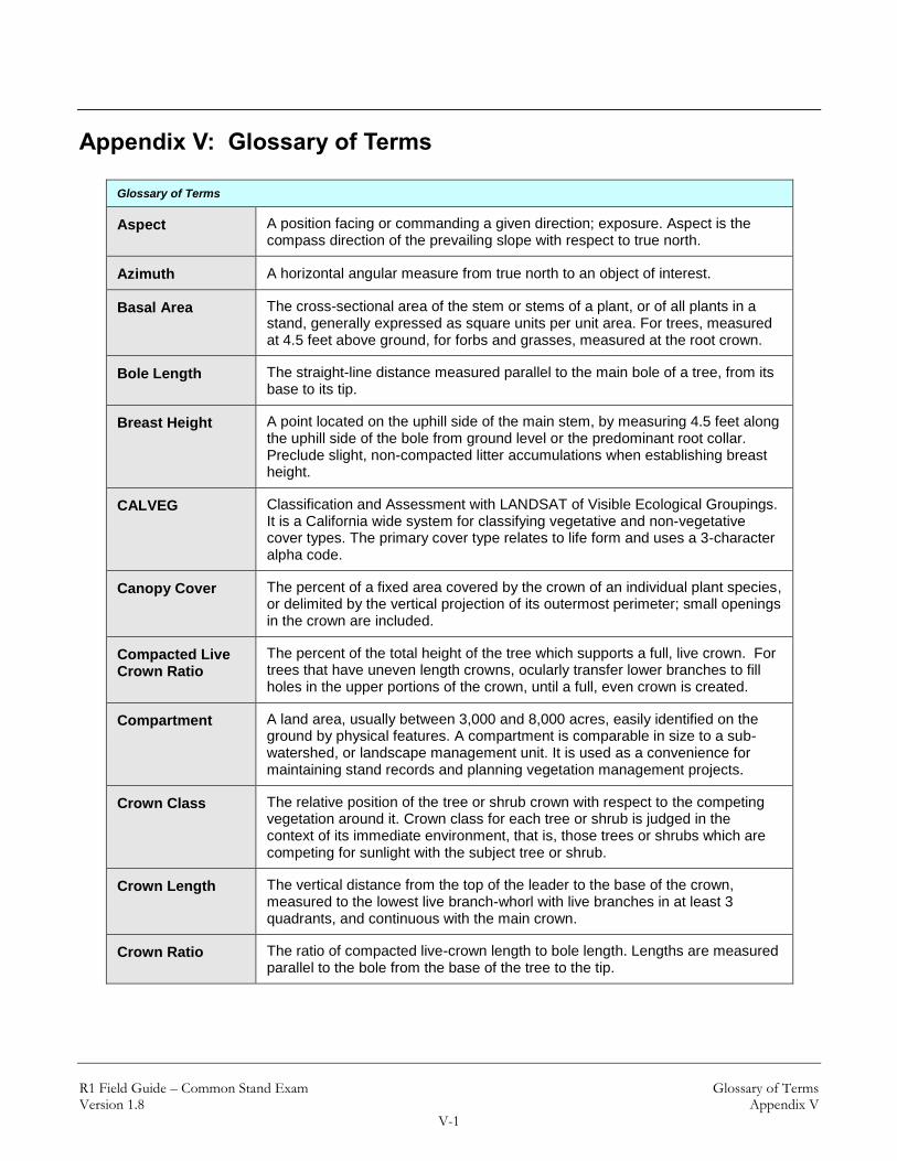
R1 Field Guide – Common Stand Exam Glossary of Terms Version 1.8 Appendix V
V-1
Appendix V: Glossary of Terms
Glossary of Terms
Aspect A position facing or commanding a given direction; exposure. Aspect is the compass direction of the prevailing slope with respect to true north.
Azimuth A horizontal angular measure from true north to an object of interest.
Basal Area The cross-sectional area of the stem or stems of a plant, or of all plants in a stand, generally expressed as square units per unit area. For trees, measured at 4.5 feet above ground, for forbs and grasses, measured at the root crown.
Bole Length The straight-line distance measured parallel to the main bole of a tree, from its base to its tip.
Breast Height A point located on the uphill side of the main stem, by measuring 4.5 feet along the uphill side of the bole from ground level or the predominant root collar. Preclude slight, non-compacted litter accumulations when establishing breast height.
CALVEG Classification and Assessment with LANDSAT of Visible Ecological Groupings. It is a California wide system for classifying vegetative and non-vegetative cover types. The primary cover type relates to life form and uses a 3-character alpha code.
Canopy Cover The percent of a fixed area covered by the crown of an individual plant species, or delimited by the vertical projection of its outermost perimeter; small openings in the crown are included.
Compacted Live Crown Ratio
The percent of the total height of the tree which supports a full, live crown. For trees that have uneven length crowns, ocularly transfer lower branches to fill holes in the upper portions of the crown, until a full, even crown is created.
Compartment A land area, usually between 3,000 and 8,000 acres, easily identified on the ground by physical features. A compartment is comparable in size to a sub-watershed, or landscape management unit. It is used as a convenience for maintaining stand records and planning vegetation management projects.
Crown Class The relative position of the tree or shrub crown with respect to the competing vegetation around it. Crown class for each tree or shrub is judged in the context of its immediate environment, that is, those trees or shrubs which are competing for sunlight with the subject tree or shrub.
Crown Length The vertical distance from the top of the leader to the base of the crown, measured to the lowest live branch-whorl with live branches in at least 3 quadrants, and continuous with the main crown.
Crown Ratio The ratio of compacted live-crown length to bole length. Lengths are measured parallel to the bole from the base of the tree to the tip.

R1 Field Guide – Common Stand Exam Glossary of Terms Version 1.8 Appendix V
V-2
Glossary of Terms
DEM Digital Elevation Model. USGS geographic elevation data distributed in raster form. Digital representation of the shape of the earth's surface. Typically digital elevation data consists of arrays of values that represent topographic elevations measured at equal intervals on the Earth's surface.
Diameter The length of a straight-line segment passing through the center of an item and terminating at its periphery.
Diameter at Breast Height (DBH)
A measure of the tree bole at breast height (4.5 feet), outside bark, perpendicular to the tree bole.
Diameter at Root Collar (DRC)
The straight line passing through the center of a cross section of a bole measured at the root collar of a shrub or tree.
Down Log Stem material (conifer or hardwood) that is lying on the ground. If a stem material is leaning more than 45 degrees from vertical, is not self-supporting, and/or in contact with the ground, it is considered a down log.
Down Woody Material
Woody pieces of trees and shrubs that have been uprooted (no longer supporting growth) or severed from their root system, not self supporting, and are lying on the ground.
Duff Layer Duff is the fermentation and humus layer of the forest floor. It does not include the freshly cast material in the litter layer. The top of the duff is where needles, leaves, and other cast-off vegetative material have noticeably begun to decompose. Individual particles usually will be bound by fungi mycelium. When moss is present, the top of the duff is just below the green portion of the moss. The bottom of the duff is the start of the soil ("A" horizon).
Elevation Vertical distance from a datum, usually mean sea level, to a point or object on the earth’s surface. Not to be confused with altitude, a reference to points above the earth’s surface.
Fuel Bed The fuel bed is the accumulation of dead, woody residue on the forest floor. It begins at the top of the duff layer and above. It includes litter, dead limbwood and bolewood from tree species, as well as dead material from shrub, herbaceous, and grass species.
Fuel Model Mathematical descriptions of fuel properties (e.g., fuel load and fuel depth) that are used as inputs to calculations of fire danger indices and fire behavior potential.
GPS Global Positioning System. A network of radio-emitting satellites deployed by the U.S. Department of Defense. Ground-based GPS receivers can automatically derive accurate surface coordinates for all kinds of GIS, mapping, and surveying data collection.
Ground Level The forest floor, made up by soil and duff layer. It does not include unincorporated woody debris that may rise above the ground line. In reference to a point of measure, it is the highest point of the ground touching the base of the object being referenced.
Group Talley A count of one or more items of the same type or species and recorded as a single line entry.
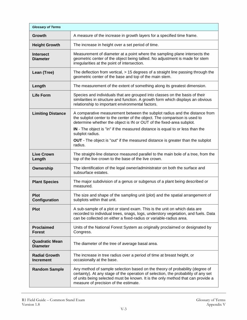
R1 Field Guide – Common Stand Exam Glossary of Terms Version 1.8 Appendix V
V-3
Glossary of Terms
Growth A measure of the increase in growth layers for a specified time frame.
Height Growth The increase in height over a set period of time.
Intersect Diameter
Measurement of diameter at a point where the sampling plane intersects the geometric center of the object being tallied. No adjustment is made for stem irregularities at the point of intersection.
Lean (Tree) The deflection from vertical, > 15 degrees of a straight line passing through the geometric center of the base and top of the main stem.
Length The measurement of the extent of something along its greatest dimension.
Life Form Species and individuals that are grouped into classes on the basis of their similarities in structure and function. A growth form which displays an obvious relationship to important environmental factors.
Limiting Distance A comparative measurement between the subplot radius and the distance from the subplot center to the center of the object. The comparison is used to determine whether the object is IN or OUT of the fixed-area subplot.
IN - The object is "in" if the measured distance is equal to or less than the subplot radius.
OUT - The object is "out" if the measured distance is greater than the subplot radius.
Live Crown Length
The straight-line distance measured parallel to the main bole of a tree, from the top of the live crown to the base of the live crown.
Ownership The identification of the legal owner/administrator on both the surface and subsurface estates.
Plant Species The major subdivision of a genus or subgenus of a plant being described or measured.
Plot Configuration
The size and shape of the sampling unit (plot) and the spatial arrangement of subplots within that unit.
Plot A sub-sample of a plot or stand exam. This is the unit on which data are recorded to individual trees, snags, logs, understory vegetation, and fuels. Data can be collected on either a fixed-radius or variable-radius area.
Proclaimed Forest
Units of the National Forest System as originally proclaimed or designated by Congress.
Quadratic Mean Diameter
The diameter of the tree of average basal area.
Radial Growth Increment
The increase in tree radius over a period of time at breast height, or occasionally at the base.
Random Sample Any method of sample selection based on the theory of probability (degree of certainty). At any stage of the operation of selection, the probability of any set of units being selected must be known. It is the only method that can provide a measure of precision of the estimate.

R1 Field Guide – Common Stand Exam Glossary of Terms Version 1.8 Appendix V
V-4
Glossary of Terms
Reconciliation Code
A code used to reflect the status of an individually tallied item with regards to previous surveys.
Slope A deviation from the horizontal.
Species A code that represents a fundamental category of taxonomic classification of an organism.
Stand A spatially continuous group of trees and associated vegetation having similar structures and growing under similar soil and climatic conditions.
Stand Exam Grid Basic data collection method for stand exams. It consists of a set of plots, separated by equal distances on a grid pattern. The lines of the grid (transects) are oriented in cardinal directions. There is a predetermined distance between plots. The number of transects and grid plots will vary depending upon the size and shape of the stand.
Stratified Sample A method of sampling forest resources where stands or polygons of similar properties are lumped into strata. This improves the efficiency of an inventory by reducing the variability within a given population. The less variability there is within a strata, the fewer samples will need to be taken to achieve a statistically valid result.
Stratum A group of stands within a condition class; similar characteristics such as forest type, tree-size class, and canopy density.
Stump The woody base of a tree remaining in contact with the soil after the trunk or main stem has been severed at a point less than 4.5 feet above ground height (measured on the uphill side).
Tree A woody perennial plant, typically large, with a single well-defined stem carrying a more or less definite crown.
Tree Age Total age of the above ground stem of a tree (not age of the root stock or the total age from seed). Total age is usually the annual ring count to the pith of the tree at breast height plus an estimate of the number of years it took the tree to reach breast height.