refuge upland wilderness review - united states fish … wilderness review is the process used to...
TRANSCRIPT

Appendix C
Eri
nV
icto
ry/T
CI
Wilderness ReviewRefuge upland

Introduction
Nomans Land Island National Wildlife Refuge C-1
Introduction
A wilderness review is the process used to determine whether or not to recommend lands or waters in theNational Wildlife Refuge System (System) to the United States Congress (Congress) for designation aswilderness. Planning policy for the System (602 FW 3) mandates conducting wilderness reviews every 15years through the Comprehensive Conservation Planning (CCP) process. Section 610 FW 4 of the Service’sWilderness Stewardship Policy provides guidance on the wilderness review process.
The wilderness review process has three phases: inventory, study, and recommendation. After firstidentifying lands and waters that meet the minimum criteria for wilderness, the resulting wilderness studyareas (WSA) are further evaluated to determine if they merit recommendation from the Service to theSecretary of the Interior for inclusion in the National Wilderness Preservation System (NWPS).
Areas recommended for designation are managed to maintain wilderness character in accordance withmanagement goals, objectives, and strategies outlined in the final CCP until Congress legislativelydesignates an area or the CCP is amended to modify or remove the wilderness proposal. A brief discussionof wilderness inventory, study, and recommendation follows.
Wilderness Inventory
The wilderness inventory consists of identifying areas that minimally meet the requirements for wildernessas defined in the Wilderness Act of 1964 (Wilderness Act).
The definition of wilderness is in section 2(c) of the Wilderness Act: “A wilderness, in contrast with thoseareas where man and his works dominate the landscape, is hereby recognized as an area where the earthand its community of life are untrammeled by man, where man himself is a visitor who does not remain. Inthis act, an area of wilderness is further defined to mean an area of undeveloped federal land retaining itsprimeval character and influence, without permanent improvements or human habitation, which isprotected and managed so as to preserve its natural conditions and which (1) generally appears to have beenaffected primarily by the forces of nature, with the imprint of man substantially unnoticeable; (2) hasoutstanding opportunities for solitude or a primitive and unconfined type of recreation; (3) has at least fivethousand acres of land or is of sufficient size as to make practicable its preservation and use in anunimpaired condition; and (4) may also contain ecological, geological, or other features of scientific,educational, scenic, or historic value.”
Wilderness Study
During the study phase, lands and waters qualifying for wilderness as a result of the inventory are studiedto analyze values (ecological, recreational, cultural, spiritual), resources (e.g., wildlife, water, vegetation,minerals, soils), public uses, and refuge management activities within the area. The analysis includesevaluation of whether the WSA can be effectively managed to preserve its wilderness character.
An “All Wilderness Alternative” and a “No Wilderness Alternative” is analyzed for each WSA to comparethe benefits and impacts of managing the area as wilderness as opposed to managing the area under analternate set of goals, objectives, and strategies that do not involve wilderness designation. Theenvironmental analysis addresses benefits and impacts to wilderness values and other resources under eachmanagement alternative. The study evaluates how each alternative will:
Achieve the purposes of the Wilderness Act and the NWPS;
Affect achieving refuge or planning unit purpose(s);

Appendix C: Wilderness Review
C-2 Environmental Assessment and Draft Comprehensive Conservation Plan
Affect that refuge’s contribution toward achieving the Refuge System mission; Affect maintaining and, where appropriate, restoring biological integrity, diversity, and
environmental health at various landscape scales; and
Meet other legal and policy mandates.
The findings of the study help determine whether to recommend the area for designation as wilderness.The information, analysis, and decisions in the CCP and associated NEPA document provide the rationalefor wilderness suitability determinations and the basic source of information throughout the public,executive, and legislative review processes that follow.
Wilderness Recommendation
There is no requirement to recommend a WSA for congressional designation as wilderness. The final CCPand record of decision document the U.S. Fish and Wildlife Service (Service) determination on a WSA’ssuitability (or unsuitability) for wilderness and decision to recommend (or not recommend) an area fordesignation.
For a WSA recommended suitable for designation, additional steps will be required including preparing awilderness study report that presents the results of the wilderness review and a Legislative EnvironmentalImpact Statement (LEIS). Once these documents are prepared, they are transmitted, along with the CCP,through the Secretary of Interior to the President of United States, and ultimately to the United StatesCongress for approval.
Wilderness Inventory of Nomans Land Island NWR
The wilderness inventory is a broad look at the CCP planning area to identify WSAs. WSAs are roadlessareas within the refuge boundaries that meet the minimum criteria for wilderness identified in Sect. 2. (c) ofthe Wilderness Act. A WSA must meet the minimum size criteria (or be a roadless island), appear natural,and provide outstanding opportunities for solitude or primitive recreation. Other supplemental values areevaluated, but not required.
The Wilderness inventory was conducted by Service staff and reviewed by the CCP Planning Teamcomprised of agency personnel representing the Service, Massachusetts Division of Fish and Wildlife andthe Wampanoag Tribe of Gay Head (Aquinnah). The inventory process and application of the wildernesscriteria is described in the following sections and summarized in Table C-1.
Evaluation of Size Criteria
The initial step to identify roadless areas and roadless islands in a planning area requires gathering landstatus maps, land use and road inventory data, satellite imagery, aerial photographs, and personalobservations of areas within refuge boundaries. Lands and waters currently owned by the Service in feetitle are evaluated. “Roadless” refers to the absence of improved roads suitable and maintained for publictravel by means of motorized vehicles primarily intended for highway use.
An inventory unit meets the size criteria for a WSA if any one of the following standards applies (610 FW4.8).
An area with over 5,000 contiguous acres. State and private lands are not included in making thisacreage determination.
A roadless island of any size. A roadless island is defined as an area surrounded by permanentwaters or that is markedly distinguished from the surrounding lands by topographical or ecologicalfeatures

Wilderness Inventory of Nomans Land Island NWR
Nomans Land Island National Wildlife Refuge C-3
An area of less than 5,000 contiguous federal acres that is of sufficient size as to make practicable itspreservation and use in an unimpaired condition, and of a size suitable for wilderness management.
An area of less than 5,000 contiguous federal acres that is contiguous with a designated wilderness,recommended wilderness, or area under wilderness review by another federal wilderness managingagency such as the Forest Service, National Park Service, or Bureau of Land Management.
Discussion
Nomans Land Island NWR is a 628-acre island. The boundary of the Refuge is the mean low water mark.All of the lands and waters within the Refuge boundary are owned by the United States, and managed bythe Service. The boundary of the Nomans Land wilderness inventory unit coincides with the Refugeboundary. The Refuge is one of eight refuges in the Eastern Massachusetts NWR Complex headquarteredin Sudbury, MA.
Waters surrounding Nomans Land Island are within a military reservation boundary restricted area.Unauthorized vessels and persons are prohibited within the restricted area. The restricted area ismonitored by the U.S. Coast Guard. Airspace over the island is restricted as well.
Remnants of old farm and military roads on the island total 4.6 miles. The original constructionspecifications and condition of these routes are unknown. The trails have been cleared of unexplodedordnance (UXO) and provide the only safe access across and around the perimeter of the island. Refugestaff and authorized agents of the Service use the trails to access the Refuge on foot and ATV formanagement activities and research. Every five years, Navy personnel use the trails for surface Munitionsand Explosives of Concern (MEC) surveillance and clearance operations. The trails are generallymaintained annually by mowing using an ATV with an attached mowing unit. Maintenance of the trailsusing herbicides applied with a backpack sprayer is an option. Due to the effects of time, storm activity, andvegetative growth, the routes are little more than 5 to 6 foot wide overgrown trails. The routes are notimproved, maintained, or used regularly for travel by vehicle by Service or Navy personnel and therefore donot meet the definition of a road.
Conclusion
Nomans Land Island meets the wilderness criteria of a roadless island of any size.
Evaluation of the Naturalness Criteria
To qualify as a WSA, an area must meet the naturalness criterion (610 FW 4.9). Section 2 (c) of theWilderness Act defines wilderness as an area that “…generally appears to have been affected primarily bythe forces of nature with the imprint of man’s work substantially unnoticeable.” The area must appear“natural” to the average visitor rather than “pristine.” The presence of ecologically intact, historic landscapeconditions is not required.
An area may include some man-made features and human impacts provided they are substantiallyunnoticeable in the unit overall. In the inventory phase, the naturalness evaluation focuses on the existingphysical impacts of refuge management activities, refuge uses, or human-caused hazards, like UXO. At thisstage, we do not disqualify an area from further study solely on the basis of established or proposedactivities or uses that require the use of temporary roads, motor vehicles, motorized equipment, motorboats,mechanical transport, landing of aircraft, structures, and installations generally prohibited in designatedwilderness. In addition, an area may not be considered unnatural in appearance solely on the basis of“sights and sounds” of human impacts and activities outside the boundary of the unit.

Appendix C: Wilderness Review
C-4 Environmental Assessment and Draft Comprehensive Conservation Plan
Discussion
The wilderness inventory documented the following man-made features and evidence of human impactrelated to historic and existing uses and management activities and uses in the Nomans Land Islandinventory unit.
Nomans Land Island has a long history of human use. Native Americans of the federally recognizedWampanoag Tribe of Gay Head (Aquinnah) used the island perhaps as early as 5,000 years ago and as asummer camp until the late 1600’s. Five pre-Contact sites have been located from surface artifacts andreported to the Massachusetts Historical Commission.
In the 1800s, European Americans lived and farmed on the island. The major occupations were fishing,raising sheep, and piloting. The island was a hunting and fishing camp in the early 1920s. From historicalaccounts, the Service has inferred the locations of “Gulltown” (a fishing village also referred to as CrowTown) and the Joshua Crane Lodge. There is one plainly visible historic ruin consisting of a stone buildingfoundation. Remnants of the low stone walls that delineated the historic property boundaries of the sheepfarms are found in the shrubland habitats on the western side of the island. A wood and stone cistern nearthe center of the island provides further evidence of the community that lived on the island. The island isthe site of the Luce Cemetery, a small family burial ground surrounded by crumbling stone walls. Thecemetery contains one known grave marked by a toppled headstone. All of these features are periodicallyovergrown and hidden by vegetation. Vegetation in the Luce family cemetery is occasionally cleared byhand-pulling or cutting. The use of ground-penetrating radar might also be used to assist in the location ofadditional cultural resources as approved by and coordinated with the Service and the Navy.
Early settlers created artificial ponds on the island, largely on the western portion, by diking the outflow ofbogs or digging below the water table and mounding the excavated dirt in a horseshoe shape to retain thewater. Ben's Pond lies just west of the center of the island and is 1,000 feet by 500 feet. Rainbow Pond lieson the east end of the island. It is about 625 feet long and has two arms extending from it (Stone andWebster 1996). Adjacent to Rainbow Pond is a small pond with a water control structure consisting of a 18to 24-inch diameter corrugated metal culvert. The metal culvert was installed in 1998 to control erosioncaused by a failed vitreous clay pipe outlet.
The military used the island as a military aerial bombardment and gunnery range with live and dummybombs from the early 1940s to 1996. In the years following WWII, a construction battalion was stationed onthe island to improve the airstrip, erect structures including a radio tower, and maintain the bombing range.All of the structures were eventually removed or demolished and no one has lived on the island since then.Although the island was cleared of surface ordnance when the military ceased operations in 1996 and twosurface clearance operations have occurred since then, frost heave and erosion may continue to expose sub-surface ordnance over time.
Plywood warning signs, approximately 4 feet by 8 feet, have been erected around the perimeter of the islandto advise the public of the dangers of the island and access restrictions.
Three black and silver Conex steel storage structures, approximately 20-25 feet long and 10 feet wide arelocated on the northern side of the island. The structures were originally moved onto the island by the Navyby crane and are used for storage of Service and Navy supplies, field camp equipment, and an ATV andmowing unit. The structures also provide emergency storm shelter for personnel.
Despite the varied human history on the island, all remnant structures are occasional, and are largelyunnoticeable upon visitation. They are largely hidden from view by acres of thick shrubland and some smalldegree of undulating topography. The trails also disappear from view by the vegetation. The island isprimarily a shrub-dominated, uninhabited place appearing to be subject to natural processes. The sightsfrom the island include unobscured views of vast expanses of ocean to the south and west, and views of

Wilderness Inventory of Nomans Land Island NWR
Nomans Land Island National Wildlife Refuge C-5
Martha’s Vineyard to the northeast where the visible buildings and lighthouses provide a sharp contrast.The sounds of the island largely consist of seasonal avifauna, wind and waves.
Conclusion
The presence of UXO may disqualify an area from wilderness consideration where “….human-causedhazards make that area unsafe for public use, such as contaminated sites or the existence of unexplodedordnance….” (610 FW 4.9D); however, public access has not been allowed on the island since the Navybegan their operations, and the Refuge will continue to enforce the ban on public access in the future.Although evidence of past human occupation and use exists, none of the existing imprints of manindividually stand out as obvious detractors from the natural characteristics of the island. On the whole,Nomans Land Island appears to have been affected primarily by the forces of nature. The Nomans LandIsland inventory unit meets the naturalness criteria.
Evaluation of Outstanding Opportunities for Solitude or Primitive Recreation
In addition to meeting the size and naturalness criteria to qualify as WSA, an area must provide outstandingopportunities for solitude or primitive recreation (610 FW 4.10). The area does not have to possessoutstanding opportunities for both solitude and primitive recreation, and does not need to have outstandingopportunities on every acre. Further, an area does not have to be open to public use and access to qualifyunder these criteria. Congress has designated a number of Refuge System wilderness areas that are closedto public access to protect ecological resource values.
Opportunity for solitude refers to the ability of a visitor to be alone and secluded from other visitors in thearea. Primitive and unconfined recreation means non-motorized, dispersed outdoor recreation activitiesthat do not require developed facilities or mechanical transport. These primitive recreation activities mayprovide opportunities to experience challenge and risk, self-reliance, and adventure.
These two opportunity “elements” are not well defined by the Wilderness Act but in most cases can beexpected to occur together. However, an outstanding opportunity for solitude may be present in an areaoffering only limited primitive recreation potential. Conversely, an area may be so attractive for recreationuse that experiencing solitude is not an option.
Conclusion
Nomans Land Island inventory unit meets the solitude criterion, but does not meet the primitive andunconfined recreation criterion. Nomans Land Island is and will remain closed to public access under theterms of the Navy transfer agreement, so there are no outdoor recreational opportunities. The island isthree miles offshore from Martha’s Vineyard. Views to the south and east are of an expanse of open ocean.Human visitors to the island are limited to Refuge and Navy personnel, contractors and authorizedvolunteers. In the future, access may be provided to members of the Wampanoag Tribe for culturalpurposes. Because visiting parties are limited in size and visitors are confined to the existing access trailsfor safety, the predominantly shrub vegetation and topographic diversity is sufficient to allow one to escapethe sights and sounds of other humans on the island. Solitude is the overwhelming force that these limitednumbers of authorized employees, staff, volunteers and tribal members experience on Nomans Land Island.
Supplemental Values
Supplemental values are defined by the Wilderness Act as “ecological, geological, or other features ofscientific, educational, scenic, or historic value.”
Nomans Land Island is a vital and unique maritime resource for migratory birds along the Atlantic Flywayand provides a diversity of habitat for passerines, raptors, waterfowl, and seabirds. Several unique andsignificant natural plant community types exist on Nomans Land Island. Much of the Refuge habitat ismaritime shrubland, which is considered rare in Massachusetts. This is found in coastal areas characterized

Appendix C: Wilderness Review
C-6 Environmental Assessment and Draft Comprehensive Conservation Plan
by patches of dense shrubs with scattered more open areas of low growth or bare ground. The small areasof maritime beach strand community and maritime dune community on the Refuge are also considered rarein Massachusetts.
Nomans Land Island also has cultural and historic supplemental values. The island is the setting for arecurring story in the oral traditions of the Wampanoag Tribe of Gay Head (Aquinnah). The Wampanoagtell that the first Indians on Martha’s Vineyard were the giant, Maushop (Proto-Algonquian for “big man”or “giant”) and his wife, Squant (derived from the seventeenth-century word, Squáuanit, the woman’s god)and their children. One Maushop story recurs frequently, but was first collected in 1792 and published inthe Massachusetts Historical Society Collections in 1806. In this story, Maushop separates Nomans LandIsland from Martha’s Vineyard by making marks with his toe across the beach, isolating a section of theisthmus that separates (or joins) them. Water rushed into the cuts on each side of the isthmus and erodedthe rest of the beach, separating the islands (Simmons 1986). In fact, Nomans Land Island was likelyattached to Martha’s Vineyard until recent geological time, within the past 1,000 years. The separation ofNomans Land Island from the Vineyard reflects rising sea level, but the event that finally removed the spitwas a storm (LaFarge 1933).
Nomans Land Island had permanent inhabitants in the eighteenth and nineteenth centuries. Two villagesarose, Gull Town (also known as Crow Town; Wood 1978) and Jimmy Town, and there were over 20dwellings and fishing shacks that were home to about 40 families. In addition, the island housed a church,school, store, gristmill, graveyard, and a boardinghouse for sailors. The three major occupations werefishing, raising, sheep, and piloting.
These supplemental values provide unique opportunities for scientific research and off-site environmentaleducation of cultural and historic resources. These values are not required for wilderness but theirpresence complements the requirements for wilderness designation. See Chapter 3 of the EA/draft CCPfor a more complete description of these supplemental values.
Wilderness Inventory of Nomans Land Island NWR
Nomans Land Island National Wildlife Refuge C-7
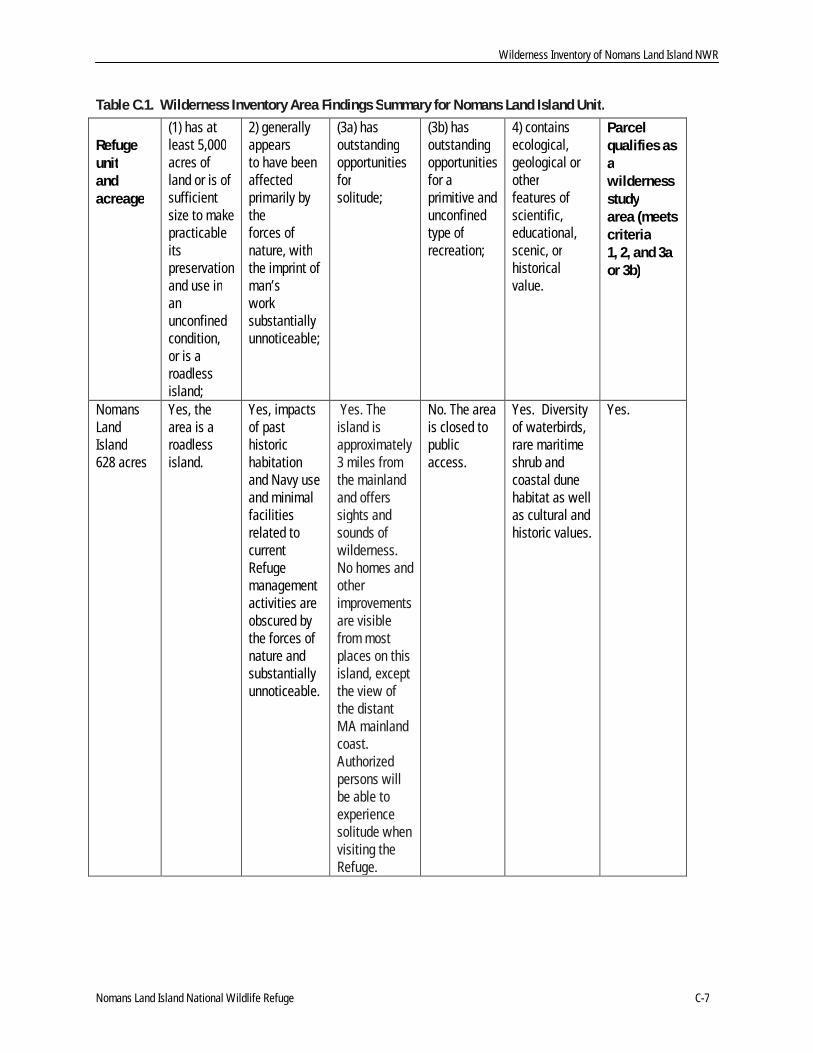
Table C.1. Wilderness Inventory Area Findings Summary for Nomans Land Island Unit.
Refugeunitandacreage
(1) has atleast 5,000acres ofland or is ofsufficientsize to makepracticableitspreservationand use inanunconfinedcondition,or is aroadlessisland;
2) generallyappearsto have beenaffectedprimarily bytheforces ofnature, withthe imprint ofman’sworksubstantiallyunnoticeable;
(3a) hasoutstandingopportunitiesforsolitude;
(3b) hasoutstandingopportunitiesfor aprimitive andunconfinedtype ofrecreation;
4) containsecological,geological orotherfeatures ofscientific,educational,scenic, orhistoricalvalue.
Parcelqualifies asawildernessstudyarea (meetscriteria1, 2, and 3aor 3b)
NomansLandIsland628 acres
Yes, thearea is aroadlessisland.
Yes, impactsof pasthistorichabitationand Navy useand minimalfacilitiesrelated tocurrentRefugemanagementactivities areobscured bythe forces ofnature andsubstantiallyunnoticeable.
Yes. Theisland isapproximately3 miles fromthe mainlandand offerssights andsounds ofwilderness.No homes andotherimprovementsare visiblefrom mostplaces on thisisland, exceptthe view ofthe distantMA mainlandcoast.Authorizedpersons willbe able toexperiencesolitude whenvisiting theRefuge.
No. The areais closed topublicaccess.
Yes. Diversityof waterbirds,rare maritimeshrub andcoastal dunehabitat as wellas cultural andhistoric values.
Yes.
Appendix C: Wilderness Review
C-8 Environmental Assessment and Draft Comprehensive Conservation Plan
Wilderness Study of Nomans Land Island NWR
The Nomans Land Island WSA (Map C-1; encompasses Refuge acquisition boundary (area outlined inwhite)) was further evaluated to determine suitability for designation, management, and preservation aswilderness (610 FW 4.13). Considerations in this evaluation included:
quality of wilderness values; and
capability for management as wilderness (or manageability) and minimum requirements/toolsanalysis.
This information provides a basis to compare the impacts of a range of management alternatives anddetermine the most appropriate management direction for each WSA.
Evaluation of Wilderness Values
The following information considers the quality of the WSAs’ mandatory and supplemental wildernesscharacteristics.
Size
Nomans Land Island WSA is a 628-acre roadless island and meets the minimum size criterion.
Naturalness
Nomans Land Island WSA generally appears to have been affected primarily by the forces of nature, withthe imprint of human uses and activities substantially unnoticeable. The impacts of human presence aresmall in terms of structures and constructed features and do not affect the overall naturalness of the WSA.
Outstanding Opportunities for Solitude
Solitude overwhelms the human spirit on Nomans Land Island.
Evaluation of Manageability and Minimum Requirements/Tools Analysis
Several management activities are required for the Service to meet responsibilities for managing NomansLand Island WSA as a national wildlife refuge as specified in relevant legislation and policies.
Jurisdiction
In 1996 all military operations were ceased on the island, and an extensive surface ordnance sweep wasconducted to ready the island for transfer to the Service. Management responsibility of the island wastransferred from the Department of Defense to the Department of the Interior in 1998, under the ActAuthorizing the Transfer of Certain Real Property for Wildlife. A transfer agreement was established byboth parties to delineate the terms of the transfer and the ongoing responsibilities of both parties. Theseterms mandate that the Service keep the island closed to the public due to safety and liability hazards, thatpermanent warning signs be erected on the island, and that the Navy maintain the right to access the islandto continue remedial operations to a level commensurate with that of an unstaffed national wildlife refuge.Close cooperation by both agencies since the transfer has allowed for UXO removal and resourcemanagement to positively affect the island.
The Navy retains responsibility for contaminants and Munitions and Explosives of Concern (MEC) thatremain on Nomans Land Island as a result of past military operations. The Navy’s current management ofresidual MEC is based on the Services designation of Nomans Land Island as an unstaffed national wildliferefuge. Any change to this designation that would result in increased exposure to MEC would requireadditional cleanup at the Service’s expense.

Wilderness Study of Nomans Land NWR
Nomans Land Island National Wildlife Refuge C-9
As noted elsewhere in this document, the Navy has been working with the Service and the MassachusettsDepartment of Environmental Protection on the cleanup of the site since the mid-1990's. Contaminantremediation has taken place and extensive clearance operations were conducted in 1998. In addition therehave been two limited follow-up MEC surface clearances, in 2003 and 2008, to address MEC that wasexposed by erosion.
Consistent with the guidance and regulations set forth in CERCLA, the Navy will conduct five year reviewsof the island so long as human use of the island is restricted. The nature and extent of these five yearreviews by the Navy of Nomans Land Island are subject to the alternative chosen in the Navy’s PhaseIII/Feasibility Study Report.
A draft Phase III/Feasibility Study (FS) Report has been prepared for the Navy which identifies andevaluates appropriate Remedial Action Alternatives (RAAs) to address the risk to safety for Nomans LandIsland. Risks to the environment, human health, and public welfare have been previously addressed andclosure attained. The feasibility of alternatives for remedial actions is evaluated according to criteria setforth in the Comprehensive Environmental Response, Compensation and Liability Act (CERCLA) and the2004 Naval Facilities Engineering Command - Guidance for Optimizing Remedy Evaluation, Selection, andDesign, and is consistent with the guidance and regulations from the Massachusetts Contingency Plan. Thepublic will be provided an opportunity to comment on the Phase III/Feasibility Study Report in 2010. Oncethat report is finalized, the Navy will prepare a Proposed Plan to indicate the preferred remedy.
We do not anticipate any conflicts with our proposed management, including wilderness, of the Refuge as aresult of these final plans. Except for Navy activities, the Service has complete jurisdiction to manageNomans Land Island NWR.
Manageability
In order to fulfill the Refuge purpose and uphold legal responsibilities, there are several generallyprohibited uses that are necessary to continue on the island (by both the Service and the Navy) that maytemporarily detract from its wilderness character. These actions would be subject to evaluation by a MRA.Though it may not possible to eliminate these activities or uses, they would be modified if possible and asnecessary to minimize any impacts that detract from wilderness character.
The use of motorboats is one such generally prohibited use. Located in the Atlantic Ocean three miles southof Martha’s Vineyard, transportation to Nomans Land Island can only occur via boat. For reasons of safetyand practicality, small motorized vessels are used to transport equipment and personnel to the island toestablish temporary field camps and conduct biological survey and monitoring activities. Service biologistsvisit the Refuge a few times a year for periods of 1 to 3 days. Two moorings installed offshore the island bythe Navy in 2008 are now property of the Service. The beaching of motorboats is necessary to unloadpersonnel and supplies. The boats are then tied up at the established moorings located about 50 feet out inthe water on the northeast side of the island. It is the intent of the Service to allow this activity to continueunder a wilderness designation.
In addition, Refuge staff utilize an ATV with attached mowing unit to maintain the existing access trails onthe island. The trails have been cleared of surface ordnance and are necessary to ensure safe access aroundand across the island for Refuge management activities.
There exist three Conex storage structures that are used for storage of the ATV and field camp suppliesand equipment. The structures are necessary to provide emergency shelter for Refuge staff in the event ofstorm or hurricane activity. The storage structures do not require regular maintenance, but might have tobe replaced in the event of damage or destruction from storms.
Installations include the eight warning signs that are erected around the perimeter of the island. These arerequired for public safety, are mandated in the transfer agreement signed with the Navy, and must be

Appendix C: Wilderness Review
C-10 Environmental Assessment and Draft Comprehensive Conservation Plan
maintained by Refuge staff. Because of the size and weight of the signs, an ATV is required to transportnew signs or materials when replacement or maintenance is required. In addition, smaller warning signsposted on Refuge beaches may also be installed, depending on the alternative chosen as part of the Navy’sPhase III/Feasibility Study. Minimal remote weather equipment might be used to monitor weather andclimate change on the island in the future.
Efforts to control invasive species on the Refuge began in 2004. Methods of control include hand pullingand herbicide application. In 2004 and 2005, Phragmites was aerially treated with glyphosate. Phragmitesmust be treated aerially because wetlands have not been cleared of UXO. Backpack sprayers with eitherglyphosate or triclopyr have been used to treat Japanese honeysuckle, Asiatic bittersweet, black swallow-wort, Phragmites, autumn olive and silver poplar. Poplar and autumn olive are also cut and the stumpstreated with glyphosate. Purple loosestrife and spotted knapweed have been pulled by hand. Treatmenthas varied each year based on the timing of trips to the island, weather and staffing.
Remediation and management by the Navy in the past has required periodic surveillance and surfaceordnance clearing. This has typically included surveillance by foot of burned areas using hand-heldmagnetometers to identify exposed and buried ordnance. The clearance operations have included retrievalof the ordnance, detonation and other activities to render it inert, and transport and disposal off the island.These activities typically required heavy equipment, which were brought in by barge to load and removeheavy UXO from the island. These operations will likely be necessary to some lesser extent in the future asfrost heave and erosion may continue to expose sub-surface ordnance over time. Though the nature andextent of the Navy’s future remedial actions will not be finalized until later this year, these clearanceoperations are short-term, temporary activities. They would be subject to evaluation by a MRA, and wouldnot permanently impact the island’s wilderness character.
None of the current or expected Refuge management activities or Navy operations and maintenance wouldpermanently diminish the wilderness character of Nomans Land Island WSA. Proposed managementactivities and protocols for invasive species control, prescribed burning, predator control, and maintenanceor stabilization of cultural sites and the Luce cemetery could carried out using the minimum impact methodsand tools, including the potential use of ground penetrating radar, to accomplish the work safely and with aminimal amount of impairment to wilderness character. The Nomans Land Island Refuge could bemanaged in the long-term to maintain wilderness character and supplemental values recognizing that usinga “minimum requirements” approach would be required for all activities.
In summary, safety, practicality, and effectiveness require the occasional use of management programs andassociated tools (some of which are generally prohibited by the Wilderness Act) to pursue achievement ofRefuge purposes, goals and objectives. Current and proposed Refuge management would be consistentwith wilderness designation and management of the Nomans Land Island WSA. Although occasionallydiminished, the area’s wilderness character and supplemental values would not be permanently impactedbecause of wilderness designation and the management described herein.

WIlderness Study of Nomans Land Island NWR
Nomans Land Island National Wildlife Refuge C-11

Appendix C: Wilderness Review
C-12 Environmental Assessment and Draft Comprehensive Conservation Plan
Alternatives
After evaluating the quality of wilderness values, manageability, minimum management requirements, thefollowing alternatives were developed and analyzed for wilderness designation. The alternatives aredescribed in detail in Chapter 2 of the EA/draft CCP.
Alternative A (Current Management)
This alternative is the “No Action” alternative required by the National Environmental Policy Act of 1969.Alternative A defines our current management activities, and serves as the baseline against which tocompare the other alternatives. The island would remain closed to public access and Refuge lands andwaters would be managed as they have been in the past to accomplish Refuge purposes in accordance withlegal and policy guidance for the System.
Our habitat management would focus on allowing natural processes and prescribed burns conducted by theU. S. Navy for UXO removal operations to maintain the diversity of the maritime shrubland habitat thatsupports migratory and nesting birds of conservation concern such as the eastern towhee and gray catbird.Other than some invasive species management, only natural processes would affect the ponds and wetlandson the Refuge that provide important breeding habitat for Virginia rail and other species of conservationconcern.
We would continue to maintain the 15 acres of herbaceous upland and 100 acres of intertidal beach androcky shore to provide suitable habitat conditions for nesting American oystercatcher, piping plover andterns as well as other shorebird, colonial waterbird, and seabird species identified as conservation concern.We would continue to enforce the ban on public access along the shoreline to prevent public use activitiesthat may pose safety risks due to UXO.
We would continue to work with our partners to monitor the island habitats for invasive plants and disease,and we would treat the vegetation to fight invasive species if we have available funding and staffing. Ourbiological monitoring and inventory program and habitat and trail management would continue at itscurrent minimal level, and would be limited by safety concerns and UXO removal conducted by the Navy.
We would continue to protect cultural resources by strengthening our relationships with the Tribe and theChilmark Historical Commission. We would consult with the Navy, Regional Archaeologist, and state andtribal historic preservation offices before committing to any ground-disturbing activities or the use ofequipment such as ground penetrating radar, as with all alternatives.
Our visitor services programs would not change; minimal off-site interpretation of the island’s resourceswould occur via our website and virtual tour. Our staffing and facilities would remain the same. Existingstaff for the refuge complex would remain in place, and the headquarters would remain at the SudburyOffice. No new staff would be hired specifically for this Refuge.
Alternative B (Enhanced Wildlife Management and Visitor Services)
In this alternative, the Service would take a more active role in managing habitats, research, monitoring andinventorying its priority natural and cultural resources. The Nomans Land Island WSA would not berecommended suitable for wilderness designation.
We would coordinate with the U.S. Navy on all management activities and to provide additional trails formonitoring and management access throughout the island. Under this alternative we would establish a fire-based management regime with prescribed burns to maintain 400 acres of desired shrubland habitatconditions to support focal nesting bird species and to provide critical shrubland stop-over habitat formigrating landbirds and butterflies. We would also explore the potential to introduce the New England

Alternatives
Nomans Land Island National Wildlife Refuge C-13
cottontail on the Refuge to support regional recovery efforts for this species of state and regionalconservation concern.
We would manage the 15 acres of herbaceous upland vegetation that provides habitat for shorebirds andterns, and the 100 acres of marine intertidal beach and rocky shore habitats to benefit marine mammals,and nesting and migrating shorebirds. We would manage the 100-150 acres of freshwater wetlandcommunities to support breeding marshbirds and native plant and animal communities, and control non-native invasive species and predators as necessary to support nesting focal species of conservation concern.We would create a habitat map for the Refuge and conduct inventories, research and monitoring on rareand special concern species.
Since no public use is allowed, we would increase visitor services programming off-site with environmentaleducation and interpretation by developing partnerships with the Tribe, Town of Chilmark, and theAquinnah Cultural Center. We would work with partners to conduct shoreline surveys for archeologicalresources at risk from erosion, develop protocols for collection and repository of artifacts and remains. Wewould increase refuge complex staff by 3 new positions for the Complex to allow for increased Biological,Visitor Services and Law Enforcement. Under this alternative we would focus on strengtheningpartnerships with the Tribe for ceremonial access. We would also increase access and managementthroughout the Refuge with the cooperation of the U.S. Navy.
Alternative C (Natural Processes Emphasis, Focal Species Management, and WildernessDesignation (Service-Preferred Alternative)
This alternative is the Service-preferred alternative for management of the Refuge over the next 15 years.It includes an array of less active management actions that, in our professional judgment, works besttoward achieving the Refuge purposes, our vision and goals (including a goal to maintain the wildernesscharacter of Nomans Land Island), and the goals of other state and regional conservation plans. We alsobelieve it most effectively addresses the key issues that arose during the planning process. Lastly, it is themost realistic given the relatively modest increase in staffing and funding that is anticipated over the next15 years.
Under this alternative, Nomans Land Island WSA would be recommended suitable for designation andinclusion in the NWPS. Since Congress has reserved the authority to make final decisions on wildernessdesignation, the wilderness recommendation is a preliminary administrative determination that wouldreceive further review and possible modification by the Director, the Secretary of Interior, or the President.However, the analysis of environmental consequences is based on the assumption that Congress wouldaccept the recommendation and designate Nomans Land Island NWR as wilderness. The information andanalyses in the CCP/EA would be used to compile a wilderness study report and legislative EIS toaccompany the wilderness recommendation.
The Nomans Land Island Wilderness would be managed according to the provisions of the Wilderness Actand Service Wilderness Stewardship Policy (610 FW 1-3). The wilderness area would be managed toaccomplish Refuge purposes and the Refuge System mission, while also preserving wilderness characterand natural values for future generations. Uses that are “generally prohibited” in wilderness (use ofmotorized vehicles, motorized equipment, and mechanical transport) would be allowed on the island foremergency purposes and when necessary to meet minimum requirements for the administration of the areaas wilderness and to accomplish Refuge purposes. “Generally prohibited uses” and proposed or new Refugemanagement activities would be evaluated through a minimum requirements analysis (MRA) to determine ifthe activities are necessary and to identify impacts and mitigating measures. The island would continue tobe accessible by motorboat.
Appendix C: Wilderness Review
C-14 Environmental Assessment and Draft Comprehensive Conservation Plan
Alternatives considered but eliminated from detailed study
Federal agencies are required by NEPA to rigorously explore and objectively evaluate all reasonablealternatives and to briefly discuss the reasons for eliminating any alternatives that were not developed indetail (40 CFR 1502.14). It was determined that there was no benefit in analyzing a partial wildernessalternative. There are no feasible or practical boundary adjustments that would improve the manageabilityof the Nomans Land Island WSA.