wilderness review - united states fish and wildlife service · appendix b: wilderness review ......
TRANSCRIPT

Appendix B
Wilderness Review


Appendix B: Wilderness Review
B‐1
WILDERNESS REVIEW PROCESS
The purpose of a wilderness review is to identify and recommend for Congressional designation National Wildlife Refuge System (Refuge System) lands and waters that merit inclusion in the National Wilderness Preservation System (NWPS). Wilderness reviews are a required element of Comprehensive Conservation Plans (CCPs). They are conducted in accordance with the U.S. Fish and Wildlife Service’s (Service) wilderness review and evaluation policy guidance (610 FW 4) and according to the refuge planning process outlined in 602 FW 1 and 3, including public involvement and National Environmental Policy Act (NEPA) compliance.
There are three phases to the wilderness review process:
1) Wilderness Inventory. The wilderness inventory identifies lands and waters that meet the minimum criteria for wilderness. These areas are called wilderness study areas (WSAs).
2) Wilderness Study. The wilderness study evaluates a range of management alternatives to determine if a WSA is suitable for wilderness designation or management under an alternate set of goals and objectives that do not involve wilderness designation. The findings of the study determine whether we will recommend an area for wilderness designation in the final CCP.
3) Wilderness Recommendation. The recommendation phase consists of reporting recommendations for wilderness designation from the Director of the Service through the Secretary of the Interior and the President to Congress in a wilderness study report. The study report is prepared following completion of the CCP. Congress has reserved the authority to make final decisions on wilderness designation.
This appendix summarizes the inventory and study phases of the wilderness review for the Great Swamp National Wildlife Refuge (refuge). Wilderness Inventory
The wilderness inventory consists of identifying areas that minimally meet the requirements for wilderness as defined in the Wilderness Act of 1964 (Wilderness Act). It represents a broad look at the planning area to identify WSAs.
The definition of wilderness is found in section 2(c) of the Wilderness Act: “A wilderness, in contrast with those areas where man and his works dominate the landscape, is hereby recognized as an area where the earth and its community of life are untrammeled by man, where man himself is a visitor who does not remain. In this act, an area of wilderness is further defined to mean an area of undeveloped federal land retaining its primeval character and influence, without permanent improvements or human habitation, which is protected and managed so as to preserve its natural conditions and which (1) generally appears to have been affected primarily by the forces of nature, with the imprint of man substantially unnoticeable; (2) has outstanding opportunities for solitude or a primitive and unconfined type of recreation; (3) has at least five thousand acres of land or is of sufficient size as to make practicable its preservation and use in an unimpaired condition; and (4) may also contain ecological, geological, or other features of scientific, educational, scenic, or historic value.”
Wilderness Study
During the study phase, lands and waters qualifying for wilderness as a result of the inventory are studied in greater detail to analyze values (e.g., ecological, recreational, cultural, economic, and symbolic), resources (e.g., wildlife, water, vegetation, minerals, and soils), public uses, and refuge management activities within the area. The analysis includes an evaluation of whether the WSA can be effectively managed to preserve its wilderness character.
An “All Wilderness Alternative” and a “No Wilderness Alternative” are analyzed for each WSA to compare the benefits and impacts of managing the area as wilderness as opposed to managing the area under an alternate set of goals, objectives, and strategies that do not involve wilderness designation. The environmental analysis addresses
Great Swamp National Wildlife Refuge Final Comprehensive Conservation Plan
B‐2
benefits and impacts to wilderness values and other resources under each management alternative. The study evaluates how each alternate will:
Achieve the purposes of the Wilderness Act and the NWPS; Affect achieving refuge or planning unit purpose(s); Affect the refuge’s contribution toward achieving the Refuge System mission; Affect maintaining and, where appropriate, restoring biological integrity, diversity, and
environmental health at various landscape scales; and Meet other legal and policy mandates.
The findings of the study help determine the WSAs suitability for management and preservation as wilderness with regard to its primary purposes as a refuge. The information, analysis, and decisions in the CCP and associated NEPA document provide the rationale for wilderness suitability determinations and the basic source of information throughout the public, executive, and legislative review processes that follow. Wilderness Recommendation
There is no requirement to recommend a WSA for congressional designation as wilderness. The final CCP and record of decision document the Service’s determination on a WSA’s suitability (or unsuitability) for wilderness and decision to recommend (or not recommend) an area for designation.
For a WSA recommended suitable for designation, additional steps will be required including preparing a wilderness study report that presents the results of the wilderness review, documentation of opportunities for public review, a copy of the final CCP, and a legislative Environmental Impact Statement (LEIS). Once these documents are prepared, they are transmitted from the Service Director to the Secretary of the Interior to the President, and ultimately to Congress for approval.
WSAs recommended as suitable for wilderness designation are managed according to the management direction provided in the final CCP. Recommended wilderness areas (RWAs) have been approved by the Director and forwarded to the Secretary for consideration. RWAs are managed to maintain their wilderness character. Proposed Wilderness Areas (PWAs) have been approved by the Secretary and forwarded to the President for consideration. PWAs are managed consistent with Service Wilderness Stewardship policy 610 FW 1-3 and sections 4.22B and C. Areas will be managed at their respective level of approval until either Congress legislatively designates the area as wilderness or the CCP is amended to modify or remove the wilderness proposal.
WILDERNESS INVENTORY OF GREAT SWAMP NWR The wilderness inventory is a broad look at the CCP planning area to identify WSAs. WSAs are roadless areas within the refuge boundaries that meet the minimum criteria for wilderness identified in Section 2(c) of the Wilderness Act. A WSA must meet the minimum size requirement (or be a roadless island), appear natural, and provide outstanding opportunities for solitude or primitive recreation. Other supplemental values are evaluated, but not required. Our inventory of potentially eligible lands and waters and the application of the wilderness criteria are described in the following sections and summarized in Table B-1. Identification Lands of Potentially Eligible for Consideration as Wilderness
Identification of potentially eligible lands and waters required gathering land status maps, land acquisition documents including pre-acquisition surveys where available, land use and road inventory data, and aerial imagery of existing refuge tracts. First-hand knowledge by staff of the current and past history of tracts was also important in refining the analysis. Only roadless lands currently owned by the refuge were evaluated. “Roadless” refers to the absence of improved roads suitable and maintained for public travel by means of motorized vehicles primarily intended for highway use. Additionally, only lands and waters currently owned by the Service in fee title were included in the
Appendix B: Wilderness Review
B‐3
evaluation. These lands and waters are included in five WSAs all contiguous with the existing Wilderness Area. Each unit is listed in Table B-1 and shown in Map B-1. WSAs are described in greater detail in the Wilderness Study section of this review.
Evaluation of Size Criteria An inventory unit meets the size criteria for a WSA if any one of the following standards applies (610 FW 4.8):
An area with over 5,000 contiguous acres. State and private lands are not included in making this acreage determination.
A roadless island of any size. A roadless island is defined as an area surrounded by permanent waters or that is markedly distinguished from the surrounding lands by topographical or ecological features.
An area of less than 5,000 contiguous Federal acres that is of sufficient size as to make practicable its preservation and use in an unimpaired condition, and of a size suitable for wilderness management.
An area of less than 5,000 contiguous Federal acres that is contiguous with a designated wilderness, recommended wilderness, or area under wilderness review by another Federal wilderness managing agency such as the Forest Service, National Park Service, or Bureau of Land Management.
1. Discussion Great Swamp NWR encompasses 7,768 acres and has an approved acquisition boundary that would allow for expansion to a maximum of 9,429 acres. Great Swamp NWR is located 26 miles from New York City within the Townships of Chatham, Harding, and Long Hill of Morris County in north-central New Jersey. The surrounding area is heavily suburbanized and, as a result, the refuge has become an island of wildlife habitat in a sea of development. The Great Swamp NWR Wilderness Area (GSWA) is 3,660 acres in size and encompasses roughly the eastern half of the refuge with all designated wilderness lands lying east of New Vernon and Long Hill Roads. The GSWA was established by Congress on September 28, 1968 (Public Law 90-352) and has the distinction of being the first Wilderness Area within the Department of the Interior.
Lands and waters west of New Vernon and Long Hill Roads lie within the “Management Area” of the refuge. These lands are not contiguous with the GSWA, being separated by paved, heavily travelled county roads. They are managed intensively for wildlife, habitat, and public use to facilitate the accomplishment of refuge purposes and the mission of the Service. They are also heavily encumbered with permanent road and structures. Since these lands and waters are not contiguous with federally designated or proposed wilderness, do not exceed 5,000 acres in total, contain significant permanent roads and structures, and must be managed in ways inconsistent with the preservation of their character as wilderness, they do not meet the criteria for WSAs and were not evaluated further.
Most, but not all, refuge lands and waters east of New Vernon and Long Hill Roads lie within the GSWA. Approximately 654 acres east of this dividing line are either contiguous with or in close proximity to the GSWA. These non-wilderness tracts were either excluded from the original 1968 wilderness designation or were acquired subsequent to designation. The GSWA is bounded by a perimeter of major utility rights-of-way (ROW; gas and electric) along its southeastern and northeastern borders. The northern border below Pleasantville Road is also bounded in large part by a ROW. All of these ROWs pre-date the establishment of the GSWA. Approximately 206 acres comprised of 33 different tracts are either partially or completely separated from the GSWA by these ROWs. Given the significant infrastructure present and the intensive management and maintenance requirements of these ROWs, they effectively serve as barriers separating the refuge lands and waters that lie beyond the ROW from the wilderness lands that lie within its perimeter. Tracts beyond the ROW can therefore not be considered contiguous with the GSWA, are far smaller than 5,000 acres, and cannot be managed in a way that preserves wilderness character and maintains unimpaired conditions. Given that, refuge lands and waters lying beyond ROWs do not meet the criteria for WSAs and were not evaluated further.

Great Swamp National Wildlife Refuge Final Comprehensive Conservation Plan
B‐4
The following five areas were identified for further evaluation as potential WSAs. All lie east of New Vernon and Long Hill Roads, are already owned by the refuge, are contiguous with the GSWA, and lie inside ROWs (see Map B-1).
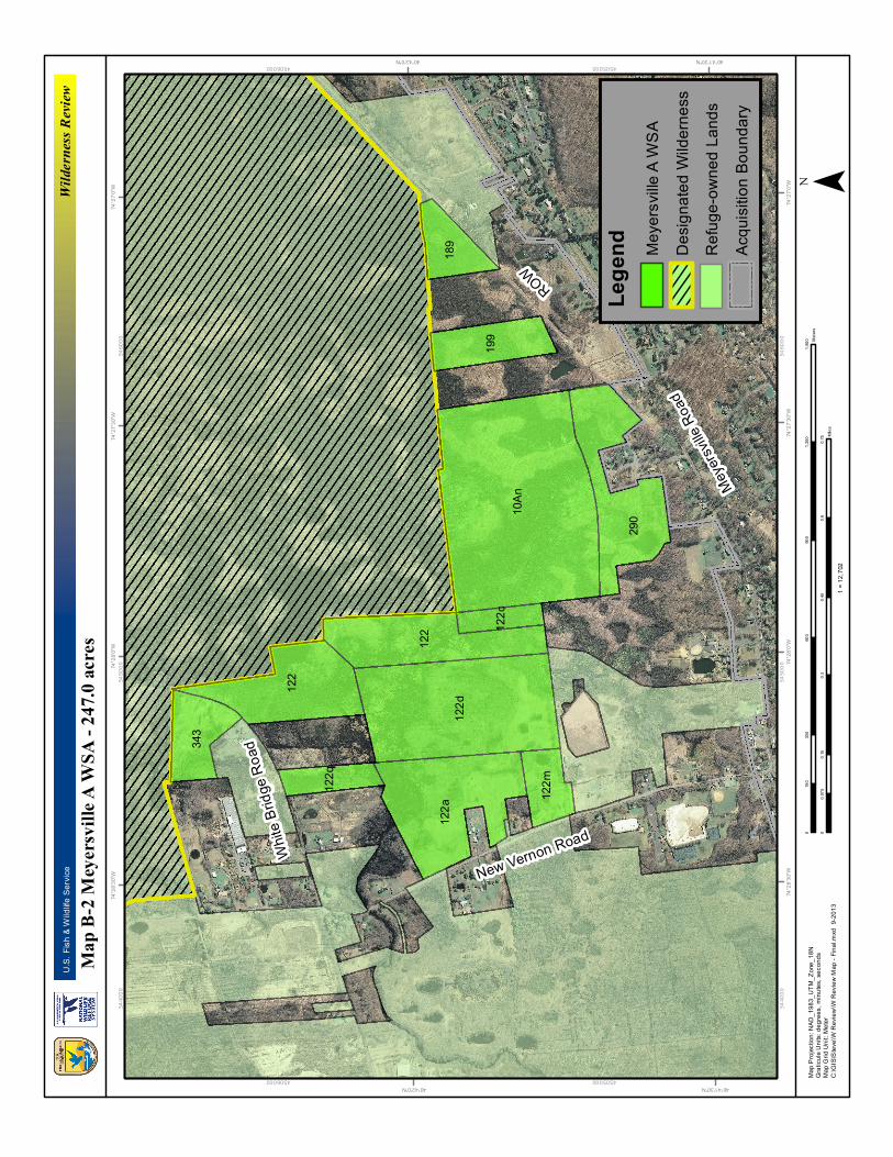
The Meyersville A WSA encompasses 247.0 acres contiguous with the southwest corner of the GSWA (see Map B-2). It is located east of New Vernon Road and north of Meyersville Road. Tracts 122 and 343 are separated by the eastern terminus of White Bridge Road. Tracts 122a and 122m front New Vernon Road while tract 122q is bounded to the north by White Bridge Road. The southeast border of tracts 189 and 290 are bounded by a utility ROW. Several private properties are adjacent to the WSA and lie within the acquisition boundary of the refuge.
The Meyersville B WSA encompasses 156.7 acres also contiguous with the southwest corner of the GSWA (see Map B-3). It is located east of New Vernon Road and north of Meyersville Road. Tract 343 is bounded to the south by the eastern terminus of White Bridge Road. Several private properties are adjacent to the WSA and lie within the acquisition boundary of the refuge.
The Long Hill Lane WSA encompasses 3.9 acres contiguous with the southeastern boundary of the GSWA (see Map B-4). It is located north of Long Hill Lane. Several private properties are adjacent to the WSA and lie within the acquisition boundary of the refuge.
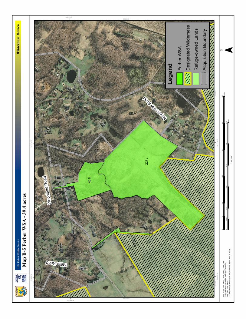
The Ferber WSA encompasses 39.4 acres contiguous with the boundary of the GSWA between Woodland and Meyersville Roads (see Map B-5). Several private properties are adjacent to the WSA and lie within the acquisition boundary of the refuge. Tract 276R (0.8 acres) is a small finger of refuge land a short distance to the west of the main WSA tracts that was acquired to provide access from Woodland Road to the GSWA. The tract follows a paved driveway between a residence to the east and a mowed field to the west before intersecting with the corner of wilderness tract 215.
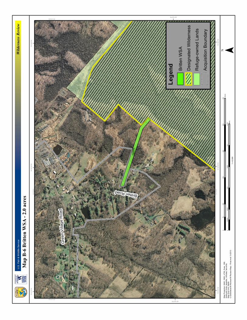
The Britten WSA encompasses 2.0 acres contiguous with the northeast boundary of the GSWA (see Map B-6). Tract #269R extends from the wilderness boundary to Britten Road. The Britten WSA is a small finger of refuge land acquired to provide access from Britten Road to the GSWA. The WSA passes closely between two residences and landscaped yards and becomes increasingly impacted by human development as it nears the road. Despite connecting directly to the GSWA, the narrow, linear shape of the WSA combined with its small size and closely proximity to human habitation makes its management as wilderness impractical.
2. Conclusion
Four of the five WSAs described above meet the wilderness size criteria of a roadless area of less than 5,000 contiguous Federal acres that is contiguous with a designated wilderness. The Britten WSA, while technically meeting the wilderness size criteria, is of such a size, shape, and location as to make its management as wilderness impractical and it has been excluded from further evaluation as a WSA. The size evaluation for each WSA is summarized in Table B-1. Evaluation of the Naturalness Criteria To qualify as a WSA, an area must meet the naturalness criterion (610 FW 4.9). Section 2(c) of the Wilderness Act defines wilderness as an area that “…generally appears to have been affected primarily by the forces of nature with the imprint of man’s work substantially unnoticeable.” The area must appear “natural” to the average visitor rather than “pristine.” The presence of ecologically intact, historic landscape conditions is not required. An area may include some man-made features and human impacts provided they are substantially unnoticeable in the unit overall. In the inventory phase, the naturalness evaluation focuses on the existing physical impacts of refuge management activities, refuge uses, or human-caused hazards. At this stage, we do not disqualify an area from further study solely on the basis of established or proposed activities or uses that require the use of temporary roads, motor vehicles, motorized equipment, motorboats, mechanical transport, landing of aircraft, structures, and installations generally prohibited in designated wilderness. In addition, an area may not be considered unnatural in appearance solely on the basis of “sights and sounds” of human impacts and activities outside the boundary of the unit.

Appendix B: Wilderness Review
B‐5
1. Discussion The wilderness inventory documented the following man-made features and evidence of human impact related to historic and existing uses and management activities and uses in the proposed WSAs.
The Meyersville A WSA has a long history of human use, predominantly agricultural use. The area was farmed and drainage ditches were dug for mosquito control and other purposes. These practices altered the hydrology of the landscape. After the refuge was established, the Service plugged drainage ditches to restore drained wetlands. Survey records show an old “woods road” leading south from historic Meyersville Road to a site containing “old cabins and a well” in the north-central portion of tract 122. The remains of an “old plank bridge” spanning Black Brook were also noted in the same area. Over time through intentional clean-up and natural decomposition, the landscape has largely reverted back to natural conditions and evidence of past human activity is substantially unnoticeable with the exceptions noted below. Land cover within the WSA is primarily wooded swamp and bottomland forest with occasional marshy areas, vernal pools, and knolls of upland hardwood forest. The WSA is an uninhabited place appearing to be subject to natural processes. In several locations, the boundary of the WSA fronts a road or ROW or abuts residential property. The sounds of the area vary depending on the proximity to roads and residential properties outside the refuge boundary. Additionally, frequent air traffic noise also impacts the soundscape of the WSA. The “sights and sounds” of human impacts and activities outside the boundary of the WSA do not disqualify the unit from being considered natural in appearance. Following acquisition, the refuge installed water control structures in the northern portion of tract 122 primarily to improve habitat management capabilities for waterfowl. Continued maintenance and use of these structures is necessary to meet the refuge’s wildlife and habitat objectives. Tract 122q lies between a remediated asbestos Superfund site to the west and a potential remediation site to the east. Asbestos was removed from the tract during clean-up operations and the slope of the western boundary was armored with rock riprap to prevent erosion from the remediated site. Tracts 122a, 122m, and 290 front busy municipal roads and/or abut private residential properties. Tract 189 spans a utility ROW and contains a 3-foot diameter culvert within a 15-foot drainage easement running north-south along its eastern edge. The refuge currently manages four grassland fields (20.5 acres) and one brushland field (2.6 acres) within the WSA using motorized equipment. These treatments are being phased out and are proposed to cease in the CCP’s preferred alternative. All fields will be allowed to revert to natural conditions.
The Meyersville B WSA has a long history of human use, predominantly agricultural use. The area was farmed and drainage ditches were dug for mosquito control and other purposes. These practices altered the hydrology of the landscape. After the refuge was established, the Service plugged drainage ditches to restore drained wetlands. Over time through intentional clean-up and natural decomposition, the landscape has largely reverted back to natural conditions and evidence of past human activity is substantially unnoticeable. Land cover within the WSA is primarily wooded swamp and bottomland forest with occasional marshy areas, vernal pools, and knolls of upland hardwood forest. The WSA is an uninhabited place appearing to be subject to natural processes. In two locations, the boundary of the WSA fronts a road or ROW. In only one location does the WSA abut a residential property (refuge-owned quarters). The sounds of the area vary depending on the proximity to roads and residential properties outside the refuge boundary. Additionally, frequent air traffic noise also impacts the soundscape of the WSA. The “sights and sounds” of human impacts and activities outside the boundary of the WSA do not disqualify the unit from being considered natural in appearance. This WSA configuration eliminates the northern portion of tract 122, tracts 122a, m, and q, and tracts 189 and 290. Removing these tracts from this WSA eliminates many of the concerns discussed under option “A” but reduces the size of the WSA by 90.3 acres. The refuge currently manages one grassland field (6.2 acres) and one brushland field (2.6 acres) within the WSA using motorized equipment. These treatments are being phased out and are proposed to cease in the CCP’s preferred alternative. Both fields will be allowed to revert to natural conditions.
The Long Hill Lane WSA is characterized by saturated to seasonally-flooded soils supporting broad-leaf deciduous forest with a scrub-shrub understory. The land has a history of minor timber extraction but the evidence of past human activity is substantially unnoticeable. The WSA is an uninhabited place appearing to be subject to natural processes. An undeveloped gas pipeline easement cuts from southwest to northeast across the bottom third of tract

Great Swamp National Wildlife Refuge Final Comprehensive Conservation Plan
B‐6
122b. In order to avoid potential future complications, only that portion of the tract not crossed by the easement is included in the WSA. An easement also crosses the southwest corner of tract 10Aa creating a small area that is unsuitable for wilderness designation. Tract 401g is developed with a house, shed, barn, and driveway and is being used as a government quarters for refuge staff. Tracts 66 and 71 are crossed by a ROW and lie partially or completely outside the ROW and have therefore been excluded. The sounds of the area vary depending on the proximity to roads and residential properties outside the refuge boundary. This area is lightly settled on the rural side of suburban. Additionally, frequent air traffic noise also impacts the soundscape of the WSA. The “sights and sounds” of human impacts and activities outside the boundary of the WSA do not disqualify the unit from being considered natural in appearance.
The Ferber WSA has had a long history of intensive human use for agriculture and, more recently, horseback riding. The remnants of an old riding track and gravel access roads are still clearly visible. The property is dominated by old field habitat with a significant invasive species component. Great Brook crosses the northern portion of the WSA dividing tract 227b from tract 401f. Riparian forest lines the banks of the brook while upland broad-leaf deciduous forest covers the western portion of the area. In two locations, the boundary of the WSA reaches out to a municipal road for access. The WSA is nearly completely surrounded by residential development. The sounds of the area vary depending on the proximity to roads and residential properties outside the refuge boundary. Additionally, frequent air traffic noise also impacts the soundscape of the WSA. The “sights and sounds” of human impacts and activities outside the boundary of the WSA do not disqualify the unit from being considered natural in appearance. In the late-2000s the refuge made earthwork improvements to the site to facilitate the management of priority wildlife species. Such management requires the frequent use of motorized equipment and other uses generally prohibited in wilderness. Tract 276R a short distance to the west follows a paved driveway between a residence to the east and a mowed field to the west before intersecting the GSWA boundary. The small size and narrow configuration of this tract combined with its close proximity to occupied residences significantly reduces its natural value.
2. Conclusion
Two of the four WSAs described above satisfy the wilderness naturalness criteria. The Meyersville A WSA does not meet the criteria due to the presence of water control structures, a culvert, an easement, a ROW, and landfill remediation infrastructure that must continue to be maintained and operated. Such operation and maintenance may require the use of generally prohibited uses. The Meyersville B WSA, on the other hand, eliminates the tracts (or portions thereof) that contain substantially noticeable structures resulting in a WSA that sufficiently satisfies the naturalness criteria to merit further consideration. Mechanical grassland and brushland treatments are being phased out in favor of natural habitat regeneration. The Long Hill Lane WSA satisfies the naturalness criteria and merits further consideration. The Ferber WSA does not meet the naturalness criteria due extensive and obvious evidence of human disturbance, the continued need for artificial structures, and the necessity to use generally prohibited uses to manage priority wildlife resources. The naturalness evaluation for these WSAs is summarized in Table B-1. Evaluation of Outstanding Opportunities for Solitude or Primitive and Unconfined Recreation Criteria In addition to meeting the size and naturalness criteria to qualify as WSA, an area must provide outstanding opportunities for solitude or primitive recreation (610 FW 4.10). The area does not have to possess outstanding opportunities for both solitude and primitive recreation, and does not need to have outstanding opportunities on every acre. Further, an area does not have to be open to public use and access to qualify under these criteria. Congress has designated a number of Refuge System Wilderness Areas that are closed to public access to protect ecological resource values.
Opportunity for solitude refers to the ability of a visitor to be alone and secluded from other visitors in the area. Primitive and unconfined recreation means non-motorized, dispersed outdoor recreation activities that do not require developed facilities or mechanical transport. These primitive recreation activities may provide opportunities to experience challenge and risk, self-reliance, and adventure.
Appendix B: Wilderness Review
B‐7
These two opportunity “elements” are not well defined by the Wilderness Act but in most cases can be expected to occur together. However, an outstanding opportunity for solitude may be present in an area offering only limited primitive recreation potential. Conversely, an area may be so attractive for recreation use that experiencing solitude is not an option.
1. Discussion The Meyersville B WSA is currently closed to the public but possesses ample opportunities for solitude or primitive and unconfined recreation, especially in the more interior areas. If designated, the WSA would be open to the public from dawn until dusk like the contiguous GSWA. One tract within the WSA abuts a road and another touches the corner of a ROW. The presence of vegetative screening, however, provides opportunities for seclusion and dispersed recreation even in these areas. The vast majority of the WSA abuts, and is buffered by, existing refuge lands, including designated wilderness. The wet, swampy habitat and presence of abundant mosquitoes and ticks during the warmer months will serve to naturally limit the number of people visiting the WSA thereby enhancing opportunities for solitude. The area is more accessible during the colder months when the ground is frozen and noxious insects have waned, however, fewer people are generally interested in visiting such areas under those conditions. Additionally, the WSA does not require developed facilities or mechanical transport for accessibility or recreational purposes. There is a great potential for primitive recreation activities that provide opportunities to experience challenge and risk, self-reliance, and adventure.
The Long Hill Lane WSA is also currently closed to the public but possesses ample opportunities for solitude or primitive and unconfined recreation, especially in the more interior areas. If designated, the WSA would be open to the public from dawn until dusk like the contiguous GSWA. The WSA abuts developed and undeveloped private lands and refuge lands, including designated wilderness. The lack of nearby access points and presence of abundant mosquitoes and ticks during the warmer months will serve to naturally limit the number of people visiting the WSA thereby enhancing opportunities for solitude. The area is more accessible during the colder months when the ground is frozen and noxious insects have waned however fewer people are generally interested in visiting such areas under those conditions. Additionally, the WSA does not require developed facilities or mechanical transport for accessibility or recreational purposes. There is a great potential for primitive recreation activities that provide opportunities to experience challenge and risk, self-reliance, and adventure.
2. Conclusion Both WSAs described above satisfy the wilderness solitude or primitive and unconfined recreation criteria. The Meyersville B and Long Hill Lane WSAs would open an additional 160.6 acres of refuge lands to the public. While not far from human development, both have the potential to provide visitors with an outstanding wilderness experience. Neither WSA currently has a trail system and the wilderness lands they abut are also largely without trails. The lack of recreational infrastructure makes these areas particularly attractive to those seeking solitude or wilderness recreation in the midst of this densely settled, heavily populated region. Since both WSAs abut the GSWA they can also serve as gateways to enjoyment of the larger wilderness area. The solitude or primitive and unconfined recreation evaluation for these WSAs is summarized in Table B-1. Supplemental Values Supplemental values are defined by the Wilderness Act as “ecological, geological, or other features of scientific, educational, scenic, or historic value.” These values are not required for consideration as a WSA but their presence is documented.
1. Discussion Both the Meyersville B and Long Hill Lane WSAs offer outstanding ecological values with features of scientific and educational interest. Land cover within the WSAs is broadly wetland, dominated by bottomland forest and marsh interspersed with occasional vernal pools and scrub-shrub and broad-leaf deciduous forest in areas of slightly higher

Great Swamp National Wildlife Refuge Final Comprehensive Conservation Plan
B‐8
elevation. These habitat types are increasingly rare in heavily developed New Jersey and provide important habitat for Federal- and State-listed rare plant and wildlife species. The WSAs have the potential to provide scientific and educational value to the larger community, since they located in the heart of one of the most highly developed, densely populated areas in the country. A unique opportunity exists to establish wilderness-compatible field research and education for scientists as well as students at the numerous neighboring schools and universities. There is potential for broader outreach to educate the public about the importance of wilderness, wetland habitat, and wildlife conservation in general.
2. Conclusion Both the Meyersville B and Long Hill Lane WSAs satisfy the supplemental values criteria. These values are not required but their presence complements the requirements for wilderness designation. The supplemental values evaluation for these WSAs is summarized in Table B-1.
Inventory Findings and Wilderness Study Areas Two areas of the five evaluated satisfy the minimum criteria for a WSA. Both the Meyersville B and Long Hill Lane WSAs are refuge-owned roadless lands contiguous with designated wilderness; appear to be primarily affected by the forces of nature; and offer outstanding opportunities for solitude or primitive and unconfined recreation. These WSAs are presented in Table B-1 and Maps B-1, B-3, and B-4.

Appendix B: Wilderness Review
B‐9
Table C-1 Wilderness Inventory
Criteria Satisfied - Yes/No & Comments
Refuge Unit and Acreage
(1) Has at least 5,000 acres of land or is of sufficient size to make practicable its preservation and use in an unimpaired condition, or is less than 5,000 acres and contiguous with a designated wilderness area;
(2) generally appears to have been affected primarily by the forces of nature, with the imprint of man’s work substantially unnoticeable;
(3a) has outstanding opportunities for solitude;
(3b) has outstanding opportunities for a
primitive and unconfined type of recreation;
(4) contains ecological, geological, or other features of scientific, educational, scenic, or historical value.
Parcel qualifies as a Wilderness Study Area (meets criteria 1, 2, and 3a or 3b).
Meyersville A
247.0 acres
Yes, unit is contiguous with a designated wilderness area.
No -- -- -- No
Meyersville B 156.7 acres
Yes, unit is contiguous with a designated wilderness area.
Yes
Yes
Yes
Yes, State and Federally-listed species habitat, important wetland, vernal pool, and upland habitat, scientific and educational values.
Yes
Long Hill Lane
3.9 acres
Yes, unit is contiguous with a designated wilderness area.
Yes Yes Yes Yes, State and Federally-listed species habitat, important wetland,
Yes
OR
Great Swamp National Wildlife Refuge Draft Comprehensive Conservation Plan and Environmental Assessment
B‐10
vernal pool, and upland habitat, scientific and educational values.
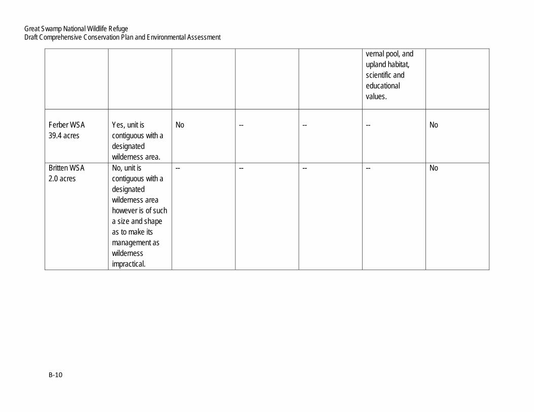
Ferber WSA 39.4 acres
Yes, unit is contiguous with a designated wilderness area.
No
--
--
--
No
Britten WSA 2.0 acres
No, unit is contiguous with a designated wilderness area however is of such a size and shape as to make its management as wilderness impractical.
-- -- -- -- No

Appendix B: Wilderness Review
B‐11
WILDERNESS STUDY OF GREAT SWAMP NWR
The two WSAs found to possess the required wilderness characteristics defined by the Wilderness Act were each further evaluated through the refuge planning process to determine their suitability for designation, management, and preservation as wilderness (610 FW 4.13). Considerations in this evaluation included:
Quality of wilderness values; Evaluation of resource values, public uses, and associated management concerns, and; Capability for management as wilderness or “manageability/”
This information provides a basis to compare the impacts of a range of management alternatives and determine the most appropriate management direction for the WSA. Evaluation of Wilderness Values
The following information considers the quality of the WSA’s mandatory and supplemental wilderness characteristics.
1. Size The Meyersville B WSA is a 156.7-acre roadless area contiguous with designated wilderness and meets the minimum size criteria.
The Long Hill Lane WSA is a 3.9-acre roadless area contiguous with designated wilderness and meets the minimum size criteria.
2. Naturalness The Meyersville B WSA generally appears to have been affected primarily by the forces of nature. The imprint of human uses and activities is substantially unnoticeable (i.e., old drainage ditches dug for agriculture and mosquito control, periodically mowed grassland and brushland fields) and does not affect the overall apparent naturalness of the WSA.
The Long Hill Lane WSA generally appears to have been affected primarily by the forces of nature, with the imprint of human uses and activities substantially unnoticeable. The impacts of human presence are minimal in terms of human-made features and do not affect the overall apparent naturalness of the WSA.
3. Outstanding Opportunities for Solitude or Primitive and Unconfined Recreation The Meyersville B WSA possesses outstanding opportunities for both solitude or primitive and unconfined recreation. The WSA is contiguous with 3,660 acres of designated wilderness. Although the WSA fronts a municipal road and ROW in two locations, vegetative screening provides sufficient cover to preserve these values. The interior of the WSA is especially well suited for solitude or wilderness-appropriate recreation.
The Long Hill Lane WSA possesses outstanding opportunities for both solitude or primitive and unconfined recreation. The WSA is contiguous with 3,660 acres of designated wilderness. Although the WSA is in proximity to residential properties, vegetative screening provides sufficient cover to preserve these values. The interior of the WSA is especially well suited for solitude or wilderness-appropriate recreation.
4. Supplemental Values Both WSAs offer outstanding ecological values with features of scientific and educational interest. The WSAs have the potential to provide scientific and educational value to the larger community, since they are located in the heart of one of the most highly developed, densely populated areas in the country. A unique opportunity exists to establish

Great Swamp National Wildlife Refuge Draft Comprehensive Conservation Plan and Environmental Assessment
B‐12
wilderness-compatible field research and education for scientists as well as students at the numerous neighboring schools and universities. There is potential for broader outreach to educate the public about the importance of wilderness, wetland habitat, and wildlife conservation in general.
5. Evaluation of Manageability and Other Resource Values and Uses Both WSAs can be managed to preserve their wilderness character in perpetuity, recognizing that a “minimum requirements analysis” and “minimum tool” approach will be required. There are no valid existing private rights or mineral rights in the WSAs. Private lands, easements, and ROWs have been specifically excluded to avoid conflicts with pre-existing rights.
The refuge lands and waters comprising both WSAs are currently closed to public use. Should these areas be designated as WSAs, appropriate administrative processes would be followed to open them to wilderness-compatible public uses such as hiking, wildlife observation, outdoor photography, and hunting.
Existing refuge management activities within the Meyersville B WSA (Tract 122d) include periodic (once every 4-8 years) motorized mechanical treatment of two fields, one grassland (6.2 acres), and one brushland (2.6 acres). These treatments are being phased out and are proposed to cease in the CCP’s preferred alternative. Both fields will be allowed to revert to natural conditions. Invasive species control and/or re-vegetation using wilderness-compatible methods (backpack sprayers, hand pulling, hand tools, etc.) may be required to facilitate the reestablishment of native plant communities. The WSA would be managed in ways that would not diminish the wilderness character of the area or make impractical its preservation as wilderness. There are no plans to construct permanent roads, facilities, or structures within the Meyersville B WSA. A minimal system of low-impact hiking trails similar to that which currently exists within the GSWA might be developed to facilitate public use.
Existing refuge management activities within the Long Hill Lane WSA are minimal and consistent with management direction in the Wilderness Act and current Service wilderness stewardship policy. None of the current or expected refuge management activities would diminish the wilderness character of the WSA or make impractical its preservation as wilderness. There are no plans to construct permanent roads, facilities, or structures within the Long Hill Lane WSA.
Study Findings and Wilderness Study Areas Wilderness designation and management of the Meyersville B and Long Hill Lane WSAs would be fully compatible with current and proposed refuge management. None of the values identified above would be forgone or adversely affected as a result of designation. Development of CCP Alternatives After evaluating the quality of wilderness values, manageability, and other resource values and uses, the following alternatives were developed and analyzed in the draft CCP/EA. 1. Alternative A (Current Management) This alternative is the “No Action” alternative required by NEPA. Alternative A defines our current management activities and serves as the baseline against which to compare the other alternatives. Under this alternative no additional lands would be proposed for wilderness designation. The lands under consideration as WSAs would remain closed to the public and continue to be managed as they have been in the past to accomplish refuge purposes and the mission of the Service in accordance with legal and policy guidance. 2. Alternative B (Enhance Biological Diversity and Public Use Opportunties)

Appendix B: Wilderness Review
B‐13
Under this alternative, both WSAs (160.6 acres) would be recommended as suitable for wilderness designation. Since Congress has reserved the authority to make final decisions on wilderness designation, the wilderness recommendations are preliminary administrative determinations that will receive further review and possible modification by the Director of the Service, the Secretary of the Interior, or the President of the United States. However, analysis of the environmental consequences of this alternative in chapter 4 is based on the assumption that Congress would accept the recommendation and designate both WSAs as wilderness. If the two WSAs are designated as wilderness, they would be managed according to the provisions of the Wilderness Act and Service wilderness management regulations (50 CFR 35) and wilderness stewardship policy (610 FW 1-4). The areas would be managed to accomplish refuge purposes and the Refuge System mission, while also preserving wilderness character and values for future generations. The use of motorized vehicles, motorized equipment, mechanical transport, or the placement of any structure or installation may only be allowed to respond to emergencies involving the health and safety of persons within the wilderness area or when necessary to meet the minimum requirements for the administration of the area as wilderness and to accomplish refuge purposes. Proposed or new refuge management activities or refuge uses would be evaluated through a minimum requirements analysis and NEPA compliance to assess potential impacts and identify mitigating measures to preserve wilderness character. As required by law and policy, another wilderness review would be conducted 15 years from the approval of the CCP, if not sooner. Refuge lands and waters, including any new acquisitions, would be evaluated for suitability as wilderness at that time. 3. Alternative C (Emphasis on Maximizing Natural Vegetation) Same as Alternative B. 4. Alternative D (Emphasis on Expanding Priority Public Uses)
Same as Alternative B. Alternatives Considered but Eliminated from Detailed Study Federal agencies are required by NEPA to rigorously explore and objectively evaluate all reasonable alternatives and to briefly discuss the reasons for eliminating any alternatives that were not developed in detail (40 CFR 1502.14). All reasonable alternatives consistent with law and policy were considered in this review. Of the five areas identified as having potential for wilderness designation, three were excluded from further evaluation for reasons detailed in the inventory and study sections of the review. The two remaining WSAs do appear suitable for wilderness designation and are being proposed for such designation as a result of this review.
GREAT SWAMP NWR RECOMMENDATIONS FOR WSA
In total, Great Swamp NWR recommends 160.6 acres to be designated by Congress as wilderness as defined by the Wilderness Act of 1964 and added to the existing GSWA.
Both the Meyersville B and Long Hill Lane WSAs contain valuable wilderness qualities and resources and have been effectively managed since the land was acquired to meet the purposes of the refuge and the mission of the Refuge System. Both WSAs are of such quality and character as to meet the purposes of the Wilderness Act and the Great Swamp NWR Wilderness Act of 1968. Great Swamp NWR has determined that the WSAs are substantially similar to contiguous designated wilderness lands both in terms of resource values, wilderness qualities, and management requirements. Therefore, Great Swamp NWR recommends these WSAs for wilderness designation.

74°2
4'0"W
74°2
4'30"W
74°2
4'30"W
74°2
5'0"W
74°2
5'0"W
74°2
5'30"W
74°2
5'30"W
74°2
6'0"W
74°2
6'0"W
74°2
6'30"W
74°2
6'30"W
74°2
7'0"W
74°2
7'0"W
74°2
7'30"W
74°2
7'30"W
74°2
8'0"W
74°2
8'0"W
74°2
8'30"W
74°2
8'30"W
74°2
9'0"W
74°2
9'0"W
74°2
9'30"W
74°2
9'30"W
74°3
0'0"W
74°3
0'0"W
74°3
0'30"W
74°3
0'30"W
74°3
1'0"W
74°3
1'0"W
74°3
1'30"W
74°3
1'30"W
74°3
2'0"W
74°3
2'0"W
74°3
2'30"W
74°3
2'30"W
40°44'30"N
40°44'30"N
40°44'0"N
40°44'0"N
40°43'30"N
40°43'30"N
40°43'0"N
40°43'0"N
40°42'30"N
40°42'30"N
40°42'0"N
40°42'0"N
40°41'30"N
40°41'30"N
40°41'0"N
40°41'0"N
5390
00
5390
00
5400
00
5400
00
5410
00
5410
00
5420
00
5420
00
5430
00
5430
00
5440
00
5440
00
5450
00
5450
00
5460
00
5460
00
5470
00
5470
00
5480
00
5480
00
5490
00
5490
00
5500
00
5500
00
4504000
4504000
4505000
4505000
4506000
4506000
4507000
4507000
4508000
4508000
4509000
4509000
4510000
4510000
01,2
002,4
003,6
004,8
006,0
0060
0Me
ters
00.5
51.1
1.65
2.22.7
50.2
75Mi
les
1 = 50
,000
Map P
rojec
tion:
NAD_
1983
_UTM
_Zon
e_18
NGr
aticu
le Un
its: d
egree
s, mi
nutes
, sec
onds
Map G
rid U
nit: M
eter
C:\G
IS\S
teve\W
Rev
iew\W
Rev
iew M
ap - F
inal.m
xd 9
-2013
U.S.
Fish
& W
ildlife
Serv
iceWi
ldern
ess R
eview
Map
B-1
Grea
t Swa
mp N
WR
Poten
tial W
ildern
ess St
udy A
reas (
WSA
s)
Lege
nd Desig
nated
Wild
ernes
sRe
fuge-o
wned
Land
sAc
quisi
tion B
ound
ary
Poten
tial W
SAs
¯
Long Hill Road
White
Bridg
e Roa
d
ROW
Fairmoun
t Avenue
South
ern Bo
ulevar
d
I-287
Lee's H
ill Road
ROW
ROW
Passaic RiverFe
rber W
SABr
itten W
SA
Long
Hill
Lane
WSA
Meye
rsville
A &
B W
SAs
ROW
Meyersv
ille Ro
adNew Vernon Road
Hardi
ng To
wnsh
ip
Chath
amTo
wnsh
ip
Bask
ing R
idge
Long
Hill T
owns
hip
A A
A
A
A
AA/B A/BA/B A/B
A/BA/B
10An
122d
290
122a
122
122
199
343
189
122m12
2q
122c
74°2
7'0"W
74°2
7'0"W
74°2
7'30"W
74°2
7'30"W
74°2
8'0"W
74°2
8'0"W
74°2
8'30"W
74°2
8'30"W
40°42'0"N
40°42'0"N
40°41'30"N
40°41'30"N
5440
00
5440
00
5450
00
5450
00
5460
00
5460
00
4505000
4505000
4506000
4506000
030
060
090
01,2
001,5
0015
0Me
ters
00.1
50.3
0.45
0.60.7
50.0
75Mi
les
1 = 12
,702
Map P
rojec
tion:
NAD_
1983
_UTM
_Zon
e_18
NGr
aticu
le Un
its: d
egree
s, mi
nutes
, sec
onds
Map G
rid U
nit: M
eter
C:\G
IS\S
teve\W
Rev
iew\W
Rev
iew M
ap - F
inal.m
xd 9
-2013
U.S.
Fish
& W
ildlife
Serv
iceWi
ldern
ess R
eview
Map
B-2
Mey
ersvil
le A W
SA - 2
47.0
acres
Lege
nd Desig
nated
Wild
ernes
sRe
fuge-o
wned
Land
sAc
quisi
tion B
ound
ary
Meye
rsville
A W
SA
White
Bridg
e Roa
d
ROW¯
New Vernon Road
Meyer
sville
Road

10An
122d
122
199
343
122c
74°2
7'0"W
74°2
7'0"W
74°2
7'30"W
74°2
7'30"W
74°2
8'0"W
74°2
8'0"W
74°2
8'30"W
74°2
8'30"W
40°42'0"N
40°42'0"N
40°41'30"N
40°41'30"N
5440
00
5440
00
5450
00
5450
00
5460
00
5460
00
4505000
4505000
4506000
4506000
030
060
090
01,2
001,5
0015
0Me
ters
00.1
50.3
0.45
0.60.7
50.0
75Mi
les
1 = 12
,702
Map P
rojec
tion:
NAD_
1983
_UTM
_Zon
e_18
NGr
aticu
le Un
its: d
egree
s, mi
nutes
, sec
onds
Map G
rid U
nit: M
eter
C:\G
IS\S
teve\W
Rev
iew\W
Rev
iew M
ap - F
inal.m
xd 9
-2013
U.S.
Fish
& W
ildlife
Serv
iceWi
ldern
ess R
eview
Map
B-3
Mey
ersvil
le B W
SA - 1
56.7
acres
Lege
nd Desig
nated
Wild
ernes
sRe
fuge-o
wned
Land
sAc
quisi
tion B
ound
ary
Meye
rsville
B W
SA
New Vernon Road
ROW
¯
Meyer
sville
Road
White
Bridg
e Roa
d

122b
74°2
5'30"W
74°2
5'30"W
74°2
6'0"W
74°2
6'0"W
74°2
6'30"W
74°2
6'30"W
40°43'0"N
40°43'0"N
40°42'30"N
40°42'30"N
5470
00
5470
00
5480
00
5480
00
4506000
4506000
4507000
4507000
024
048
072
096
01,2
0012
0Me
ters
00.1
0.20.3
0.40.5
0.05
Miles
1 = 10
,000
Map P
rojec
tion:
NAD_
1983
_UTM
_Zon
e_18
NGr
aticu
le Un
its: d
egree
s, mi
nutes
, sec
onds
Map G
rid U
nit: M
eter
C:\G
IS\S
teve\W
Rev
iew\W
Rev
iew M
ap - F
inal.m
xd 9
-2013
U.S.
Fish
& W
ildlife
Serv
iceWi
ldern
ess R
eview
Map
B-4
Long
Hill
Lane
WSA
- 3.9
acres
Lege
nd Desig
nated
Wild
ernes
sRe
fuge-o
wned
Land
sAc
quisi
tion B
ound
ary
Long
Hill
Lane
WSA
Meye
rsville
Road
ROW
Fairmoun
t Avenue
¯
ROW
401g
66
122b
7110Aa
Long
Hill L
ane
227b
401f
276R
74°2
7'30"W
74°2
7'30"W
74°2
8'0"W
74°2
8'0"W
40°44'0"N
40°44'0"N
5450
00
5450
00
5460
00
5460
00
4509000
4509000
014
028
042
056
070
070
Meter
s0
0.07
0.14
0.21
0.28
0.35
0.035
Miles
1 = 6,
000
Map P
rojec
tion:
NAD_
1983
_UTM
_Zon
e_18
NGr
aticu
le Un
its: d
egree
s, mi
nutes
, sec
onds
Map G
rid U
nit: M
eter
C:\G
IS\S
teve\W
Rev
iew\W
Rev
iew M
ap - F
inal.m
xd 9
-2013
U.S.
Fish
& W
ildlife
Serv
iceWi
ldern
ess R
eview
Map
B-5
Ferb
er W
SA - 3
9.4 ac
res
Lege
nd Desig
nated
Wild
ernes
sRe
fuge-o
wned
Land
sAc
quisi
tion B
ound
ary
Ferbe
r WSA
Wood
land R
oad
215
¯
Meyersvi
lle Road
Miller Road
269R
74°2
6'0"W
74°2
6'0"W
74°2
6'30"W
74°2
6'30"W
74°2
7'0"W
74°2
7'0"W
40°44'0"N
40°44'0"N
5470
00
5470
00
4510000
4510000
015
030
045
060
075
075
Meter
s0
0.075
0.15
0.225
0.30.3
750.0
375
Miles
1 = 6,
500
Map P
rojec
tion:
NAD_
1983
_UTM
_Zon
e_18
NGr
aticu
le Un
its: d
egree
s, mi
nutes
, sec
onds
Map G
rid U
nit: M
eter
C:\G
IS\S
teve\W
Rev
iew\W
Rev
iew M
ap - F
inal.m
xd 9
-2013
U.S.
Fish
& W
ildlife
Serv
iceWi
ldern
ess R
eview
Map
B-6
Britt
en W
SA - 2
.0 ac
res
Lege
nd Desig
nated
Wild
ernes
sRe
fuge-o
wned
Land
sAc
quisi
tion B
ound
ary
Britte
n WSA
215
¯
Gree
n Villa
ge R
oad
Britten Road
