redevelopment of malili residential precinct · malili centre is expected to play a major role in...
TRANSCRIPT

REDEVELOPMENT OF MALILI RESIDENTIAL PRECINCT
BY
MUTUKU AUGUSTINE MULINGE
B65/3292/2010
A planning Development Project Submitted in Partial Fulfillment of the Requirements
for the Degree of Bachelor of Arts in Urban and Regional Planning.
Department of Urban and Regional Planning
University of Nairobi
June 2014

ii
DECLARATION
This Planning Development Project is my original work and has not been presented for a degree
in any other university.
Signed …………………………………… Date …......................................
MUTUKU AUGUSTINE MULINGE
B65/3292/2010
(Candidate)
This Planning Development Project has been submitted for examination with my approval as the
University Supervisor
Signed …………………………………. Date………………………….
MR. CHARLES DADU KARISA
(Supervisor)
iii
DEDICATION
I dedicate this development project to the Almighty the Only True and Wise God who has given
me the strength to carry out the development project work. To my parents and dear friends who
have given me support and encouragement during the whole process, may the Almighty always
abide with you.

iv
ACKNOWLEDGEMENT
My Acknowledgement to the Almighty God the only true and Wise God who gave me good
health the energy to carry out this development from the start to completion.
My sincere gratitude goes to my supervisor, Mr. Charles Dadu Karisa for the valuable advice,
guidance, patience and support he has given me while undertaking this development project
from the initial stages to the completion.
I would also like to appreciate the input of Mr. Z. Maleche whose insights broadened my
thinking and made this work possible.
Lastly, am grateful to all my wonderful family members and friends for their unfailing support
and encouragement during my entire schooling period. This academic journey has been an uphill
task but your encouragement has seen me this far. I shall forever be indebted to you all for your
kind assistance.

v
ABSTRACT
Malili Centre is expected to play a major role in the development of Konza Techno City. This
Centre is expected to house the workers for the proposed city because of its close proximity.
However the current developments within the Centre are more likely to lower the value of the
techno city. This development project endeavored to provide a sustainable residential estate
within Malili Centre thus positioning Malili Centre in a better position to benefit from the
construction of Konza Techno City.
The development project was guided by finding from the data collected and analyzed from the
area during the research stage. The data collection process involved the use of both primary and
secondary sources. The primary data sources included data collected directly during field work
i.e., direct observation, administration of questionnaires among others. The secondary data
employed the use of published and unpublished documents, library research and internet sources.
Further data collection and analysis occurred at the design stage. All the analyzed data guided in
the choice of the best development approach to be adopted within Malili Centre.
The development project examined three possible alternatives for the future development of the
estate. These included: redevelopment approach, selective redevelopment approach as well as an
integrated approach. After evaluation of the three alternatives, the redevelopment approach was
chosen as it effectively addresses the problems being experienced in Malili Centre. This
development project has provided building typologies that are sustainable within Centre and
which ensure effective use of land as a resource and promote access to services.
Monitoring and evaluation in this development project aimed at enhancing effective
implementation of the proposed designs to achieve the expected outcomes which include but not
limited to, sustainable residential estate which is easily accessed, promotes access to services,
and provides decent and affordable housing units.

vi
TABLE OF CONTENTS
DECLARATION .................................................................................................................................... ii
DEDICATION ....................................................................................................................................... iii
ACKNOWLEDGEMENT ...................................................................................................................... iv
ABSTRACT ............................................................................................................................................ v
TABLE OF CONTENTS........................................................................................................................ vi
LIST OF MAPS ...................................................................................................................................... x
LIST OF PLATES .................................................................................................................................. xi
LIST OF TABLES ................................................................................................................................ xii
CHAPTER 1: INTRODUCTION ......................................................................................................... 1
1.1. Overview ................................................................................................................................. 1
1.2. Research Project Title: ............................................................................................................. 1
1.3. Summary of Major Findings. .................................................................................................... 1
1.3.1. Uncontrolled land subdivision and development. .............................................................. 1
1.3.2. Uncontrolled land use ....................................................................................................... 1
1.3.3. Poor road infrastructure .................................................................................................... 2
1.3.4. Poor housing conditions ................................................................................................... 2
1.3.5. Inadequate basic service provision .................................................................................... 3
1.3.6. Emergence of informal business activities......................................................................... 4
1.3.7. Environmental degradation ............................................................................................... 4
1.4. Summary of Research Recommendations ................................................................................. 5
1.4.1. Reorganization of land uses within the Centre. ....................................................................... 5
1.4.2. Provision of better and decent housing ................................................................................... 5
1.4.3. Provision of transport infrastructure ....................................................................................... 5
1.4.6. Provision of adequate access to basic services. ....................................................................... 6
1.5. Development project title: Development of Malili residential precinct. ..................................... 7
1.6. Reasons for choice of development project ............................................................................... 7
1.7. Area coverage .......................................................................................................................... 7
1.8. Objectives ................................................................................................................................ 7
1.9. Assumptions ............................................................................................................................ 7

vii
1.10. Scope of the development project and organization of the project chapters ............................ 8
1.11. Data Needs and Requirements .............................................................................................. 9
1.11.1. Data Sources ...................................................................................................................... 10
1.12. Methods of Data Collection ................................................................................................ 11
1.12.1. Methods for Primary Data Collection ................................................................................. 11
1.12.2. Methods of secondary data collection ................................................................................. 11
1.12.3. Methods of Data Analysis .................................................................................................. 11
1.10.4. Methods of Data presentation ............................................................................................. 11
1.10.5. Limitations ......................................................................................................................... 11
1.17. Definition of key terms ............................................................................................................. 12
CHAPTER TWO: REVIEW OF POLICY GUIDELINES .............................................................. 13
2.1. The Constitution of Kenya, 2010 ............................................................................................. 13
2.2. Policy framework........................................................................................................................ 13
2.2.2 National Housing Policy........................................................................................................ 13
2.3. Relevant legislations ................................................................................................................... 14
2.3.1 The Physical Planning Act (cap 286) ..................................................................................... 14
2.3.2. The County Government Act, 2012 ...................................................................................... 15
2.3.3. The Land Act, 2012.............................................................................................................. 15
2.3.4. Environmental Management and Coordination Act (EMCA 1999)........................................ 15
2.3.5. Water Act, 2002 ................................................................................................................... 15
2.3.6.Public Health Act, Cap 242 ................................................................................................... 15
2.4. Relevant plans ............................................................................................................................ 16
2.4.1. Konza Technology City Local Physical Development Plan ................................................... 16
2.4.2. KonzaTechno city Buffer Local Physical Development Plan................................................. 16
2.5. Planning standards and guidelines ............................................................................................... 16
CHAPTER 3: SITUATION ANALYSIS ............................................................................................ 25
3.1. Location context of project ..................................................................................................... 25
3.1.1. Regional Context ............................................................................................................ 25
3.1.2. Local Context ................................................................................................................. 26
3.2. Background of project area and historical context ................................................................... 30
3.3. Site analysis ........................................................................................................................... 30
3.3.1. Topography and drainage ............................................................................................... 30

viii
3.3.2. Geology and soils ........................................................................................................... 31
3.3.3. Climate and Vegetation ........................................................................................................ 32
3.4. Population and demographic characteristics ............................................................................ 36
3.4.1. Population ...................................................................................................................... 36
3.4.2. Demographic characteristics ........................................................................................... 36
3.4.3. Socio- economic characteristics ...................................................................................... 37
3.5. Land use analysis ................................................................................................................... 37
3.5.1. Land tenure analysis ....................................................................................................... 37
3.5.2. Land use ......................................................................................................................... 37
CHAPTER 4: PROJECT PLANNING, DESIGN AND IMPLEMENTATION ............................... 38
4.1. Planning and design of projects. .................................................................................................. 38
4.1.1. Development of spatial plan ................................................................................................. 40
4.2. Site Planning/Design Process Stages ........................................................................................... 48
4.2.1. Detailed design formulation stage ......................................................................................... 49
4.2.3. Implementaton schedule ....................................................................................................... 57
CHAPTER 5: EVALUATION AND MONITORING. ...................................................................... 63
5.1. Monitoring and Evaluation Stages of the Implemented Development Project............................... 63
5.1.1. Steps in monitoring and evaluation of the project. ................................................................. 63
5.2. Guidelines for the Implementation Process .................................................................................. 65
5.3. Site Management Plan ................................................................................................................ 66
REFERENCES...................................................................................................................................... 68

ix
LIST OF FIGURES
Figure 1: Temperature on Malili Centre. ................................................................................................ 33 Figure 2: Population projection for Malili sub location 2009 -2014 ........................................................ 36 Figure 3: Preliminary design of the Proposed Residential Area .............................................................. 53 Figure 4: Final design ............................................................................................................................ 54 Figure 5: site plan for the adopted alternative ........................................................................................ 55 Figure 6: 3D representation of the whole estate ...................................................................................... 56 Figure 7: Summary of evaluation and monitoring stages ........................................................................ 64

x
LIST OF MAPS
Map 1: Site Layout of Greenspan estate ................................................................................................. 22 Map 2: Local context of project area. ..................................................................................................... 28 Map 3: Project Site within Malili Centre ................................................................................................. 28 Map 4: Soil and geology Map ................................................................................................................ 32

xi
LIST OF PLATES Plate 1: image showing location of Green Span estate ............................................................................ 21 Plate 2: Malili Centre in the national context.......................................................................................... 25 Plate 3: Location of Malili along Mombasa Nairobi Road ...................................................................... 26 Plate 4: Locational context of the project area. ...................................................................................... 27 Plate 5: An excavation revealing the black cotton soils found in the project site ..................................... 31 Plate 6: Savanna grasslands and sparse bushes a character of Kapiti plains ............................................. 34 Plate 7: Aerial view of the project site before establishment of Malili Centre. ........................................ 34 Plate 8: Location of project site ............................................................................................................. 38 Plate 9: Conceptual Design .................................................................................................................... 52

xii
LIST OF TABLES Table 1: Recommended land uses, minimum plot sizes, setbacks plot coverage and building typologies in Malili Centre ......................................................................................................................................... 17 Table 2: Residential neighbourhood standards ....................................................................................... 18 Table 3: Road specifications within Malili Centre .................................................................................. 19 Table 4: Summary of car parking space requirement .............................................................................. 20 Table 5: Summary of site analysis ......................................................................................................... 35 Table 6: Project outputs and outcomes ................................................................................................... 39 Table 7: Population projection ............................................................................................................... 49 Table 8: Housing demand Projection up to the year 2030 ....................................................................... 50 Table 9: Adopted design standards......................................................................................................... 51 Table 10: Project implementation time frame ......................................................................................... 58 Table 11: Site management Plan ............................................................................................................ 66

1
CHAPTER 1: INTRODUCTION
1.1.Overview
This chapter provides introductions that give the title, findings and recommendations of the
planning research project; a summary of the development project title, objectives and
methodology. This chapter builds the foundation of the development project.
1.2.Research Project Title:
Emerging Human Settlement Patterns around the Planned Konza City: A Case of Malili Centre
1.3.Summary of Major Findings.
1.3.1. Uncontrolled land subdivision and development.
Malili Centre is a rapidly growing Centre with uncontrolled and unplanned development with a
rapid rate of land subdivision without any guiding plans. The uncontrolled development has led
to reduction of the aesthetics value of the center.
Most of the development occurs in a scattered manner and this makes provision of necessary
infrastructure services expensive. Construction is still ongoing on the plots which have been
subdivided into smaller portions of 50m by 30m. These constructions do not leave any space for
installation of necessary infrastructure. This in future will force demolition of some structures to
pave way for installation of the necessary infrastructure if the development in the Centre is to be
sustainable. This is an expensive venture and this can be avoided by controlling the development
before it escalates to uncontrollable levels.
1.3.2. Uncontrolled land use
Malili Centrehas a variety of land uses. These land uses include residential, commercial,
educational and transportation. These land uses are disorganized and are scattered within the
Centre. This is because there is no guiding plan and no effective control. This gives the Centre a
disorderly character. This poses a major challenge in service provision in that it will be an
expensive venture to service the disorganized activities in future. For instance some structures
within the residential area have been converted to schools and religious facilities. Some of the

2
structures are multipurpose serving both as schools during the week and religious facilities
during the weekend. The disorganization of land uses has made the Centre to acquire a slum like
character and this led to the demolition of the initial structures in the settlement.
1.3.3. Poor road infrastructure
The Centreis served by one class A road, the Nairobi- Mombasa road and two minor roads
Malili-Konza road and Malili-Katumani road. The Nairobi-Mombasa road lacks traffic calming
infrastructure within the Centre. Thisroad, which separates the Centre into two, is usually very
busy and vehicles usually move at very high speeds. Residents have to wait for long before they
can cross from one side of the Centre to the other. Others even risk by crossing the road while
running. This poses a great risk to the road users within the Centre. The road also lacks
pedestrian walk ways.
Both Malili-Konza road and Malili-Katumani road are earth roads. Malili-Konza road is a major
link of Konza Centre another rapidly growing Centre, to the main Nairobi-Mombasa road.
Malili-Katumani Road connects Malili Centre to Katumani Agricultural Research Institute.
These two roads are characterized by huge potholes in the middle of the roads. These potholes
have rendered some sections of the road impassable and road users have created ways in the
adjacent plots. In some sections along the road, the road reserves have been encroached into by
the upcoming developments thus leaving no space for road expansion and installation of other
infrastructure like power and water.
Heavy vehicles usually park within the Centre creating congestion. The parking currently used is
informal and there is no designated route for entering or leaving the parking. The location and
lack of proper signage to direct the trucks is the major cause of the congestion of the long
vehicles. This causes other vehicles to park beside the main road creating more congestion.
1.3.4. Poor housing conditions
Majority of the structures within the Centre are built using iron sheets for both wall and roofing.
The use of the temporary material for construction makes it risky to install services like
electricity.

3
These structures lack basic amenities like toilets and bathrooms this pose a health risk to the
residents who live in this structures.
The initial structures built within the Centre were demolished by the government because they
gave the Centre a slum like character. However the more structures are being built to
accommodate the increasing population. It was observed that there is rapid immigration in this
area with more than 95% of the residents having migrated into the area within the last 4 years.
This has led to a significant rise in the temporary structures in an effort to provide shelter.
This form of housing poses a great risk in case of emergencies like fires and disease epidemics
because of lack of the basic amenities which support quality living.
1.3.5. Inadequate basic service provision
Basic services are important in any human settlement. Malili Centre has inadequate provision of
the following basic services:
1.3.5.1.Inadequate Educational facilities
Due to influx of population in the area, there is mushrooming of primary school within the
Centre. There are at least five private owned primary schools within the Centre. Most of the
schools have inadequate facilities. It was observed that majority of the schools are not registered
and they are run by untrained teachers.
The example of Elite Academy situated on a plot measuring 50m by 30m and has one structure
housing pupils from standard 1 to standard 6. This school is run by three untrained teachers.
There is no public school within the Centre and this force the residents to fully depend on the
informal primary schools. From the field study it was ascertained that the land set aside for
public primary school has been grabbed by a private developer. Thus the access to free and
quality education within the Centre is greatly constrained.

4
1.3.5.1. Poor access to Water
The Centre is faced with the challenge of access to clean and adequate water for both domestic
and commercial uses. Water vendors supply the residents with the much needed commodity. A
20 litre Jeri can costs an average of Kshs. 30 and at times costs Kshs.80 during serious water
shortages. Water vending businesses have taken over the normal supply of clean water by the
government thus compromising on the right of the residents to access of adequate and clean
water at affordable prices.
1.3.5.3. Lack of sanitation facilities
There are no sanitation facilities provided in the area. The Centre lacks a sewer system and major
sanitation facilities like public toilets. Business operators within the Centre are forced to use
facilities within the residential structures which are also not adequate. Residential structures use
Pit latrines and waste pits to dispose human and domestic waste respectively.
1.3.5.4. Security
Security in the area is highly compromised by the absence of security personnel. Major security
threats within the Centre are mugging and theft. The residents have to travel more than 15 km to
Salama Police Station to report insecurity instances. The area has increasing population and
insecurity instances are expected to rise.
1.3.6. Emergence of informal business activities
There is emergence of roadside business along the Nairobi Mombasa road taking advantage of
the passengers boarding and alighting along the road. Other business activities are established on
the road reserves of the Malili-Konza road and Malili-Katumani road. These business activities
are creating conflict between road users and the business activities.
1.3.7. Environmental degradation
The Centre lacks a waste collection and waste disposal system and residents are using different
ways of disposing the waste generated in their homes and business premises. Majority of the
residents use pit latrines and waste pits to dispose human and domestic waste respectively.
However waste generated by the commercial activities is disposed besides the roads. This has led
to accumulation of waste on some parts of the roads. These forms of waste disposal are not
sustainable and pose a threat to the environment.

5
An area with a depression south of the Centre is currently used by traders to dispose their waste.
However, majority of the traders especially roadside sellers dispose the waste generated in their
businesses beside the road. Most of the households use pit latrines to dispose their human waste
and waste pit to dispose other domestic wastes but these are only found in the few permanent
structures within the Centre. These pose a threat to the fragile ecosystem.
1.4. Summary of Research Recommendations
1.4.1. Reorganization of land uses within the Centre.
For there to be harmonious and sustainable development a local physical development plan for
the Centre need to be developed. This will ensure allocation of space for the various land uses
within the Centre. This will ensure separation of non-compatible land uses and incorporation of
compatible land uses.
1.4.2. Provision of better and decent housing
The demand of housing currently within Malili Centre outweighs the supply of housing units.
Furthermore the housing being provided is temporary in nature. There is need to provide decent
housing with access to basic services. This will entail:
• Replacement of the temporary structures with permanent structures
• Provision of basic amenities like toilets and drainage within the structures
• Realignment of the structures to create better aesthetics and ease of access.
1.4.3. Provision of transport infrastructure
The infrastructure development will include: Tarmacking Malili-Konza road and Malili-
Katumani road. These two roads link Malili Centre to Konza Centre and Katumani Centre
respectively. The Malili-Konza road is one of the major links of Konza Centre to the main road,
Nairobi Mombasa Highway. The infrastructure facilities needed include:
1. Provision of pedestrian facilities on both roads within the Centre to ease movement of
people within the Centre.
2. Provision of better drainage facilities on the road infrastructure in the area.to drain off the
water accumulating in the road making them impassable.

6
3. There is also need to provide parking for long distance vehicles within Malili Centre.
Currently the vehicles have created an informal parking within the Centre and the parking
is usually congested because of limited space.
1.4.6. Provision of adequate access to basic services.
Provision of adequate education facilities. The area needs public educational facilities to be
established. The area already had enough population to support primary schools and with
expected increase in population there is need to establish a secondary school.
1.4.6.1. Provision of water reticulation system
The Centre need to be supplied with adequate and clean water. This water should be able to
power the sewerage facilities proposed for the area.
o Introduction of better waste management
o Promotion of the use of sustainable sources of energy
1.4.6.2. Provision of a formal market
The major motivation of people moving into the Centre was to search for employment. This had
led to rise in a number of economic activities within the Centre. Among the activities are the
business established along the road reserve. There is thus a need to allocate space where the
where the roadside sellers can be moved into and better structures constructed for their use. It is
therefore recommended that a more formal market be established in Malili with the
establishment of adequate provisions for commercial and industrial activities.

7
1.5. Development project title: Development of Malili residential precinct.
This will entail construction of permanent residential structures which are easily
accessible and are provided with the basic services like water, sanitation facilities and
electricity.
1.6. Reasons for choice of development project
The choice of the development project is backed by the following reasons:
• The provision of housing is a basic need and enshrined in the Kenyan Constitution. The
inadequacy of housing should thus be given the first priority in the redevelopment of
Malili Centre.
• Currently the Centre faces shortage of housing and if the problem is not addressed
urgently there will be development of a slum. To redevelop the area will then proof to be
an expensive venture because it will entail the demolition of the congested structures.
• Future expectation in increase in population will create pressure on the few residential
units thus the need to increase their supply.
1.7. Area coverage
Malili Centre is divided into two sections by the Nairobi- Mombasa highway, the eastern
side and western side. The project is intended to cover the western side of the Centre an
area of 20.20hectares where currently residential structures are concentrated.
1.8. Objectives
i. Development of a model residential cluster for Malili Centre
ii. Prepare housing layout designs that promote access to services, optimal utilization of
land, and encourage sustainable use of resources.
iii. Propose measures for land use control and regulation of proposed house layout
iv. Provide an implementation framework for the project, including monitoring and
evaluation
1.9. Assumptions
The project will only be viable under the following assumptions
• The current increase in population will continue leading to increased demand in
housing.

8
• The speculation of the growth of Konza Techno city which is a major attraction of
population into Malili Centre.
• The various stakeholders will be willing to take up and implement the project.
1.10. Scope of the development project and organization of the project chapters
Chapter 1: Introduction
This chapter introduces the research project by giving a summary of the main research findings
and the various recommendations to be adopted to tackle the problem researched on the preferred
choice of the recommendation is stated and the Development Project title stated. This chapter
has the following other sections: justification of the development project, location and area
coverage of the project area, objectives and assumptions of the development project and the
methodology for the development project.
Chapter 2: Policy Review
This chapter has dealt with review of relevant policies, plans planning policies and design
guidelines. Planning standards at national, regional, and urban are reviewed in this chapter. This
provides the guidelines on the planning design and implementation of the project.
Relevant case study has also been analyzed.
Chapter 3: Situational Analysis of the Project Area
Locational context of the study area (from regional level to neighborhood level is explained in
this chapter. The background of the study area and its historical context is tackled in this chapter.
Physical and natural environmental characteristics of the site where the project will be
implemented and their effects on the project are analyzed. This chapter also analyses the
population and demographic characteristics of the project area. The various land uses within the
project area and their effect on the project analyzed. Lastly the institutional, legal and financial
issues of the project area are stated.
Chapter 4: Project Planning, Design and Implementation
This section articulates the planning projects and designs generated, expected outputs and
outcomes of the project and implementation strategies and programs for the project as directed
by the project objectives. This chapter has the implementation schedule where the time frame,

9
phasing costing and resource requirements and the various roles of the stakeholders involved in
the project implementation are stated.
Chapter 5: Monitoring and Evaluation
The stages in monitoring and evaluation of the project, guidelines for the implementation process
and environmental management plan re tackled in this chapter.
Development Study Methodology
This section describes, in detail, the types of data that were sought, sources of such data, the
subjects targeted for the study, methods of data collection and data analysis. All these had to be
informed by the project objectives. A summary of all the whole methodology is finally
represented in the form of a data needs matrix. The methodology is important because it shows
the systematic stages or plan followed while undertaking this project.
1.11. Data Needs and Requirements
The information that was sought was on policy and legal guidelines which comprised of zoning
regulations and development control information; planning standards on housing and support
activities; lessons from relevant case studies; location and historical development of the project
area.

10
Physical and environmental characteristics of the area; population and demographic
characteristics of the area; and land use patterns of the project area.
1.11.1. Data Sources The data mentioned above was got from both primary and secondary sources. The physical and
environmental characteristics of the area and the land use information were gathered through site
analysis. The major methods of collecting this data were observation, field sketching, mapping
and photography.
The data collected through secondary sources can be classified into policies, legal legislation and
planning guidelines and standards.
Policies
The policies analyzed are housing policy and land policy
The legal information sourced from the Kenya Constitution (2010) and the Acts of Parliament
relevant to the area of study.
Acts of parliament
The acts of parliament reviewed are Physical Planning Act (1996), Urban Areas and Cities Act
(2011), Devolved Government Act (2011),Water Act (2002),Public Health Act, Land Act and
Environmental Management and Coordination Act (1999).
Planning guidelines and standards
Data on planning guidelines and standards was sourced from Konza Techno City Buffer Local
Physical Development Plan, Konza Technology City Local Physical Development Plan, Physical
Planning Handbook (2008), the A.J. Metric Handbook and the Building Code.

11
1.12. Methods of Data Collection
Data collection for this project involved both primary and secondary data collection methods.
1.12.1. Methods for Primary Data Collection
Photography
This basically entailed taking pictures of various phenomena for illustration purposes. The major
features that were captured through photography comprised of the physical ones e.g. buildings,
transport networks, drainage systems, people undertaking various activities among others.
Field Sketching
The researcher also drew sketches of various features also for illustration purposes. These
included elevations of buildings along the corridor, cross-sections of the road reserve and
perspective drawings at various sections of the corridor.
Observation
Land uses within the project area, site characteristics and measurement were noted and recorded
down.
1.12.2. Methods of secondary data collection
This involved the review of policies, acts of Parliament, review of plans reading of relevant
books and documents and analysis of case studies.
1.12.3. Methods of Data Analysis This is whereby the data collected was cleaned, sieved and synthesized for meaningful
interpretation of findings. Quantitative data was analyzed using Excel and SPSS programs.
Spatial data was analyzed using GIS tools and ArchiCAD.
1.10.4. Methods of Data presentation The results of the analysis provided the information needed for the writing of the report. The
analyzed data is presented informs of maps, plates and figures.
1.10.5. Limitations The following limitations were faced during the project:
There were time and financial constraints experienced
Malili being an upcoming settlement much of the information about it is not documented.

12
1.17. Definition of key terms
Housing unit: A residence such as a house, apartment, mobile home, or room(s) within a larger
structure that provides a space for occupants making up a single household to live and eat. For a
room or apartment to be defined as a housing unit, it must be distinctly separated from other
living spaces within the building. It must be directly accessible from an outer door or through an
interior door in a shared hallway rather than by walking through another household's living
space.
Plot coverage: Plot coverage is the extent of plot covered by the building(s) or structure and this
is expressed in terms of percentage.
Plot ratio: the plot ratio of a building is obtained by dividing the gross floor area (GFA)) of the
building by the area of the site on which the building is erected.
Set back: means the minimum distance between any portion of any building and a road
boundary or centerline of a road.

13
CHAPTER TWO: REVIEW OF POLICY GUIDELINES
2.1. The Constitution of Kenya, 2010
The Kenyan Constitution provides the framework for formulation of various policies and
legislation to guide development within the country. The constitution of Kenya under article 43
(1) (b) provides that every Kenyan citizen has a right to accessible and adequate housing and
sanitation. The enjoyment of this right is not limited to only those living in major urban areas but
also to those living in rural areas and those in the developing urban settlements. Thus the state
needs to put initiatives to ensure that Kenyan Citizens enjoy this right. Currently the residents is
Malili Centre do not enjoy this right fully because of lack of basic services within the Centre.
2.2. Policy framework
2.2.1 Kenya Vision 2030
Kenya’s vision is to become a globally competitive and prosperous nation with a high quality of
life by the year 2030. This vision covers the period 2008-2030 and it aims at transforming Kenya
into a newly industrialized middle income country. It is based on three pillars namely, economic,
social and political. These three pillars will lead to an adequately and decently-housed nation in a
sustainable environment through better development of and access to affordable and adequate
housing. The vision identifies key flagship projects throughout the country which are expected
to take the lead in generating rapid and widely shared growth and create jobs for Kenyans. With
successful implementation of these projects will lead to an increased demand in quality housing
and reduced supply of informal houses thus the need for provision of housing. The vision targets
production of 200,000 units of housing annually.
2.2.2 National Housing Policy
The national housing policy intents to arrest the deteriorating housing conditions country wide
and to bridge the shortfall in housing stock arising from demand that surpasses supply mostly in
urban areas. The policy aims to enable the poor to access housing and basic services and
infrastructure necessary for a healthy living environment mostly in urban areas; facilitate
increased investment by the formal and informal private sector in the production of low and
middle income urban dwellers among others. The policy has broad objectives which geared
towards achieving sustainable human settlement development. Some of the objectives are:
• To facilitate progressive realization of the right to adequate housing by all
14
• To promote the development and ownership of housing that is functional, healthy
aesthetically pleasant and environmentally friendly
• To earmark and set aside and for public development in urban areas.
• Access to land and security of tenure for all socio- economic groups.
• To assist the low income earners and economically vulnerable groups in housing
improved production.
• To improve the quality of housing stock.
• To provide and improve infrastructural facilities in both the rural and urban areas so as to
improve human settlements and living environments
• To protect the environment of human settlements and ecosystems from pollution,
degradation and destruction in order to attain sustainable development.
2.2.3. Land policy
The Land policy sets out the goals and direction for the management of land and sets out
measures and guidelines to be adopted to achieve optimal utilization and management of land.
The policy recognizes that, uncontrolled development, urban sprawl, land use conflicts,
environmental degradation, and spread of slum development have been land use challenges in
the country. To address such issues the policy proposes preparation of among others urban and
peri-urban land use plans.
2.3. Relevant legislations
2.3.1 The Physical Planning Act (cap 286)
This is the main statute that provides for planning at national, regional and local levels. The law
mandates the Director of Physical Planning to formulate National, Regional and Local
development policies, guidelines and strategies. The Act also indicates the process to be
followed in plan preparation which includes public participation. This Act vests power on the
governments (county governments) to ensure orderly development, regulate zoning, approve
development plans and prohibit unauthorized developments through reinforcement of the law.
Thus any development within Malili Centre will Have to be approved by the County
Government of Makueni.

15
2.3.2. The County Government Act, 2012
The County Government Act, 2012 mandates County Governments to carry out the planning
function at the county level. The Act stipulates that one of the objectives of county planning is to
ensure harmony between national, county and sub-county spatial planning. Konza Techno city
project which has stimulated the growth of Malili Centre is a national project which also affects
two other counties.
2.3.3. The Land Act, 2012
The Land Act provides for sustainable administration and management of land and land based
resources nationally. The land within Malili Centre need to be managed in a sustainable to ensure
the current development will not affect future developments and ensure the environment is
conserved and well managed.
2.3.4. Environmental Management and Coordination Act (EMCA 1999)
EMCA, 1999 provides for the establishment of an appropriate legal and institutional framework
for the management of the environment. The legislation entitles every Kenyan the right to a clean
environment and tasks the state to protect the environment and ensure sustainable use of land and
other natural resources such as wildlife. The Act provides for the formation of NEMA which is
mandated to approve plan and projects ensure they meet all environmental requirements.
2.3.5. Water Act, 2002
An Act of Parliament to provide for the management, conservation, use and control of water
resources and for the acquisition and regulation of rights to use water; to provide for the
regulation and management of water supply and sewerage services. The Act provides for the
formation of water service board which has the mandates to control all services related to water
and sewerage.
2.3.6.Public Health Act, Cap 242
The Act provides for control of nuisance on any land or premises or other condition liable to be
injurious or dangerous to health such as overcrowded dwelling or premises. It also provides that
dwellings and premises must be provided with adequate drainage and appropriate sanitation
facilities. Currently the project lack any waste disposal system and drainage system thus the need

16
to be provided with adequate drainage and sanitation facilities to prevent diseases related to poor
sanitation.
2.4. Relevant plans
2.4.1. Konza Technology City Local Physical Development Plan
This Local Physical Development Plan (LPDP) has been prepared to enhance the realization of
Kenya Vision 2030. Konza Technology City has stimulated the growth of centres around.
Among these centres is Malili Centre which is at the southern part of the Techno city. This plan
addresses the developments taking placing place in Malili and Konza centres.
2.4.2. KonzaTechno city Buffer Local Physical Development Plan
This plan guides development around the proposed Konza Techno City. It is a 10 year plan
guiding development over an area of 20,677 Ha. Among the objectives of the plan include
identifying the likely impacts of Techno City to its periphery and vice versa, classifying the land
into appropriate land uses and setting standards, regulations and restrictions for land use and
buildings. The plan gives the principles that shall guide development within the area of the buffer
zone.
2.5. Planning standards and guidelines
The Konza Techno City Buffer Local Physical Development Plan zones Malili Centre as both a
commercial and residential Centre. The plan categorizes the area into various zones. Zone A
will be conservation area, Zone B will be modern agriculture and Zone C will be commercial
area. Malili Centre where the project site lies is categorized as zone C. the plan proposes that
Zone C will be further subdivided to create a sub-zone to cater for residential user particularly
low and medium density residential. The Table below shows the permitted land uses including
those under special conditions. The plan gives the following planning specifications are to be
followed when designing structures within the Centre.

17
Table 1: Recommended land uses, minimum plot sizes, setbacks plot coverage and building
typologies in Malili Centre
Permitted Use Minimu
m plot
size(Ha)
Set backs Max.
no. of
floors
Plot
covera
ge
Building Typologies
F R S
Commercial,
residential,
Hospitality, Public
Purpose
0.05 5 2.5 5 75% Apartments, flats, shopping
malls, complex
High density
residential(singles
family, multi-family
units)
0.05 6 3 3 5 50% Flats, apartments,
semi-detached row houses
Medium to low
density residential
0.20 6 3 3 2 50% Bungalows, maisonettes,
villas
Source :( Konza Techno City Buffer LPDP).

18
Table 2: Residential neighbourhood standards
Type of dwelling No. of dwellings per hectare Space allocation per dwelling
(m2) (Include built-up area and
circulation)
Bungalow Detached
Low Density 10 1000
Medium Density 16 500
High Density 35 285
Semi-detached and Row
housing
Low Density 20 417
Medium Density 32 333
High Density 70 250
Multi-family dwelling
Low Density 50 200
Medium Density 60 167.6
High Density 70 142.8
Special Density 133 75
Source: Physical Planning Handbook, 2008
Circulation
All plots within an area need to be accessed to ease provision of services within the area. Service
infrastructure is usually laid along the transportation routes so as to ensure they can be easily be
accessed for maintenance and repair.The table below shows road specifications within Malili
Centre.

19
Table 3: Road specifications within Malili Centre
Road Name Classification Reserve Pedestrian
Walkways(Both
Sides)
Cycle Paths
(Both Ways)
Nairobi-Mombasa A109 60m 4.5m 2m
Konza road D522 20m 1.5m 1.5m
Ulu road E411 60m 4.5m 2m
Konza East E412 18m 1.5m 1.5m
Locals roads, unopened
reserves in Malili and
Konza centres
9m
Source: Konza Techno City Buffer LPDP
Car Parking Space
Public parking spaces should be provided in urban areas within residential areas, industrial
zones, commercial zones and social facilities, recreation and sports areas, in the central
commercial and business zones. In residential areas, where on-street parking is not practicable,
public car parks should be provided. The maximum distance between a dwelling and its
associated parking area should be 50m. A standard of 15-35 square meters parking space per car
is recommended. The dimensions recommended are:
Flush Parking
5.0-6.5m by 2.5m for cars 10.0m by 3.3m for buses 30.0m by 4.0m for trailers and trucks.
Angle Parking
5.0-6.5m by 2.5m for cars 10.0m by 3.3m for buses 40.0m by 2.5m for trailers and trucks at an
angle of 30 degrees. Angle parking has an advantage of concentrating more vehicles within a
given location but demand wider road reserves than flush parking. The following are standards
for car parking requirements:-

20
Table 4: Summary of car parking space requirement
Usage One Car space for every usage
Housing 2 houses or lodgings
Specialized market place 50 to 60sq. m of covered area
Market 30 to 50 sq. of covered area
Office and Administration 50 to 60 sq. m of covered area
Hotel 5 to 8 beds
School (a) 0.5 classroom/secondary school and above
(b) 1.0 classroom/ below secondary school
level
Restaurant, Cinema and Theatre 12 seats
Mosque / churches 10 to 12 prayer space
Hospital 5 to 10 beds
Sports field 10 to 20 seats or spectators
Industrial establishment and workshops 6 to 10 workers
Source: Physical Planning Handbook, 2008
Case study: Green span estate
Green span estate is located within a high populated area within Nairobi city and despite the
population pressure the estate provides for a decent living environment unlike Malili Centre
where increase in population has led to emergence of informal and temporally structures.
The estate is located in Nairobi Umoja Phase 5 area. It is bordered by Kayole spine road to the
north east and savannah road to the south east. A residential estate with 1000 housing units. The
residential estate is characterized by two housing typologies; maisonettes and apartments the
estate has been developed in three phases. The estate has provided for a shopping mall where
various services and goods can be obtained all under one roof.
The housing estate has ensured maximum circulation where by each plot is accessed by an
access road. The estate has tapped on the green energy by the following attributes

21
• Each unit has a solar panel
• Rain water harvesting
• Solar powered street lighting
• A naturally ventilated design allowing for constant air flow.
The estate has adopted on street parking angular and parallel parking. All housing units within
the estate drain in a common sewer which a sustainable method of liquid waste disposal.
Plate 1: image showing location of Green Span estate
Source: Google earth 2014

22
Map 1: Site Layout of Greenspan estate

23
Green span mall houses various commercial activities. This thus promotes for mixed use development.
Maisonettes type of housing. The houses are fitted with solar heaters thus reducing the cost of energy consumption.

24
Lessons learnt
1. Use of renewable sources of energy
The project area is located within the tropics where direct solar insolation is experienced
all year round and thus the area has the potential for tapping solar energy in small scale to
be used for lighting within the housing units and on the streets.
2. Provision of adequate circulation within the residential units
All the plots within the study area need to be provided with adequate access to ensure
easy delivery of services and goods within the residential estate
3. Green spaces give an area an aesthetic value and thus the need to improve the aesthetic
value of the project area.
4. Integration with other land uses ECD School and a shopping mall which are fully
operational.
5. Rain water harvesting to reduce overdependence on the supplied water.

25
CHAPTER 3: SITUATION ANALYSIS
3.1.Location context of project
3.1.1. Regional Context
The project area, at regional context is located in Makueni County at Malili Centre. Malili Centre
is near the border of Makueni and Machakos County. The project area is bordered by the
Nairobi Mombasa Highway (A109) to the East and Malili Ulu road to the south.
Plate 2: Malili Centre in the national context

26
Plate 3: Location of Malili along Mombasa Nairobi Road
3.1.2. Local Context
The project site is located at the western part of Malili Centre and is bordered by Nairobi
Mombasa highway to the east and Malili Konza road to the south and Konza Techno City
boundary to the North.

27
Plate 4: Locational context of the project area.

28
Map 2: Local context of project area.
Source: Konza Technology City LPDP and modified by author
Map 3: Project Site within Malili Centre

29
30
3.2. Background of project area and historical context Malili Center is a new urban area forming in the south east of the proposed Konza Techno city.
This Centre has developed after subdivision of Malili ranch in the year 2006. Shareholders were
allocated plots according to the number of shares one owned. During the subdivision there was
allocation of commercial plots to every shareholder. This Centre is separated into four portions
by the Mombasa- Nairobi and Ulu-Malili-Katumani road. The Mombasa-Nairobi highway runs
in a north-south direction and Ulu-Malili-Katumani road runs diagonally in a north east- south
west direction. This urbanization has been fuelled by expectations arising from the impending
construction of a new city on the 5000 acres acquired by government for that purpose. The
expectations have led to acceleration of subdivision of ranches into small parcels which are sold
to speculative developers who are positioning themselves strategically to benefit from the Konza
city project.
The form and character that the Malili urban area has taken is largely informal, devoid of
planning and infrastructure provision. Most of the permanent developments are occurring along
the main road as ribbon development. The center lacks a distinctive form separating land uses
and most of the developments occurring away from the main highway are semi-permanent
structures. The area also lacks provision for public infrastructure to support the budding urban
area.
The Centre has plots ranging from 1/8 acres which are privately owned under leasehold. Going
by the type of development coming up in the area, it is evident that there has been further
uncontrolled subdivision of land. The parcels of land adjacent to and in the vicinity of Malili
center are of 7.8 Acres each and are also under private ownership. The formalization process for
ownership of these parcels is still in progress. Owners of the plots currently have allotment
letters as show of proof of ownership of the plots.
3.3.Site analysis
3.3.1. Topography and drainage
The land generally slopes gently in a westerly direction. It lies in between a series of hills thus
forming a basin. The North West side slopes steeply from north to the south.

31
3.3.2. Geology and soils The soils within the project site are black cotton soils which are about five meters deep. These
soils cannot support built structures and thus the site need to be excavated to reach the firm
ground where the structures can be built.
Plate 5: An excavation revealing the black cotton soils found in the project site
Source: Field study 2014

32
Map 4: Soil and geology Map
Source: Konza City Buffer Zone Local Physical Development Plan
3.3.3. Climate and Vegetation
3.3.3.1. Rainfall
The area where the project site lies is categorized as an Arid and Semi-Arid Land (ASAL) since
it does not receive sufficient amounts of precipitation. Annual rainfall ranges from 150mm to
650mm. The area is thus unsuitable for rain-fed agriculture but it is suitable for ranching and
irrigation agriculture. It is also suitable for urban development. Due to the area being Arid and
Semi-Arid Land and long sun shine periods the area has potential for solar energy.
3.3.3.2. Temperature
The temperature of the area covering Makueni ranges from 150C-290C. This means the average
daily temperature is 220C. The table below shows a summary of monthly temperatures.

33
Figure 1: Temperature on Malili Centre.
Source: Kenya Meteorological Department
These are the same temperatures that are experienced within the project site.
3.3.3.3. Vegetation
The project site generally lies in the Kapiti Plains. The vegetation is savannah grassland with
sparse shrubs. With the low amount of rainfall received in the area the vegetation is mostly
stunted. Most of the vegetation has been destroyed by charcoal burners and frequent fires mostly
during the dry season. Within the project site the vegetation has been cleared to pave way for
construction.

34
Plate 6: Savanna grasslands and sparse bushes a character of Kapiti plains
Source: Konza Local Physical Development Plan (2012-2030
Plate 7: Aerial view of the project site before establishment of Malili Centre.
Source: Konza Local Physical Development Plan (2012-2030)

35
Table 5: Summary of site analysis
Site attribute Opportunities Challenges
Topography Large portion of the site is
generally flat thus suitable for
urban development
The likelihood of flooding is high thus
creating a need for an elaborate drainage
system
Vegetation Vegetation on site in sparse thus
there will be less destruction of the
natural
environment during construction
activities
Exposure to flush flooding due to the bare
soils.
Views and
neighborhood
The surrounding hills give the Centre
a unique identity and pristine and
scenic setting.
The bare hills may accentuate flooding
within the city
Soils The soil profile is suitable for urban
developments
Deeper excavation of the soils to reach a firm
base
Neighboring
Infrastructural
facilities
Ease of connectivity by use of A109
the E412 Malili Ulu road
Need for interchanges along the A109 and
extending the Konza railway line to KTC

36
3.4. Population and demographic characteristics
3.4.1. Population
The population of Malili sub location according to 2009 population and housing census was 796
and the population growth. (KNBS, 2009).The population growth rate is 2.8%.
Figure 2: Population projection for Malili sub location 2009 -2014
Year Population Size
2009 796
2010 818
2011 882
2012 902
2013 907
2014 909
Source: KNBS 2009 and modified by author 2014
Majority of the respondents were male with about 70% of those interviewed being male and 30%
being female. This is due to the population dynamics of the center whereby the male population
is the majority. The ages of those interviewed ranged from 20 years to 60 yrs. Majority of those
interviewed were between the age of 26 years to 30 years representing 54% of those interviewed.
3.4.2. Demographic characteristics
The mean house size in the Centre is 3 persons per household. This is because the population is
comprised of young population which have moved in the area in search for job opportunities.
During the field study it was observed that majority of the residents have at least attended
schools with 39.13% having completed primary level, 37.78% having attended secondary school
and 26.09% having completed tertiary level.
Other than the basic education, some residents within the Centre have other skills which enable
them get their daily living. However majority of the residents regard themselves as unemployed
with those employed accounting for 17.54% of the resident population.

37
3.4.3. Socio- economic characteristics
Urban-based economic activities in the area are those that tend to capitalize on pooling of
population and do well in areas with high population density with existing or emerging urban
character such as Malili Centre. The following economic activities take place within the site.
These activities can be classifies into commercial activities, educational and land transactions.
Cereal stores, diesel pump, food and beverage outlets such as restaurants, butcheries, food kiosks
and pubs, garages (bicycle, motor cycle and car) and puncture repair, money transfer services
among others. The site is has three educational institutions which are privately owned.
3.5. Land use analysis
3.5.1. Land tenure analysis
Malili center was originally part of Malili ranch. It has plots ranging from 1/8 acres which are
privately owned under leasehold. Going by the type of development coming up in the area, it is
evident that there has been further uncontrolled subdivision of land. The parcels of land adjacent
to and in the vicinity of Malili Centre are of 7.8 Acres each and are also under private ownership.
The formalization process for ownership of these parcels is still in progress, (LPDP, 2013).This
plots have been further subdivided into small uneconomical units which have already been sold
out to speculative developers.
3.5.2. Land use
Land within and around the project site has been put into various uses. The land uses are:
residential, commercial, transportation, educational, religious and health.
However majority of the plots are yet to be developed owing to initial freezing of development to
pave way for planning. This provides an opportunity to ensure that all developments are
according to the required specifications
38
CHAPTER 4: PROJECT PLANNING, DESIGN AND IMPLEMENTATION
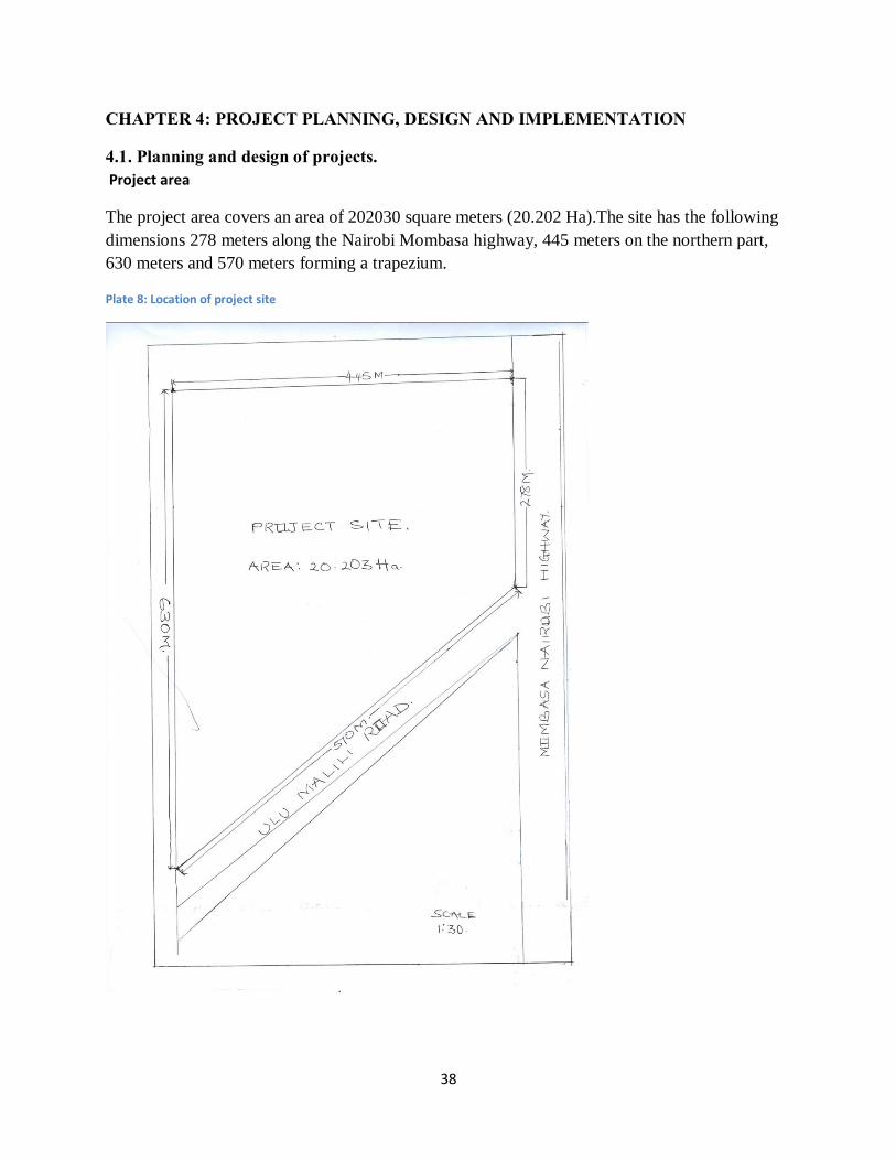
4.1. Planning and design of projects. Project area
The project area covers an area of 202030 square meters (20.202 Ha).The site has the following dimensions 278 meters along the Nairobi Mombasa highway, 445 meters on the northern part, 630 meters and 570 meters forming a trapezium.
Plate 8: Location of project site

39
Project outputs and outcomes
The project is expected to provide a residential design that will lead adequate housing units, propose housing typologies that promote optimal access to services at minimum cost at the same time conserving on the use of land. The project will also provide guidelines for implementation of the residential cluster. The project outcomes are summarized in the table below.
Table 6: Project outputs and outcomes
Project objective Project outputs Project outcomes
Development of a model residential
cluster for Malili Centre
Better planned residential estate Decent housing
Improved security
Improved provision of education
Ease of movement
Prepare housing layout designs that promote
access to services, optimal utilization of land,
and encourage sustainable use of resources.
Permanent houses that are well served with basic services
like water and have better methods of waste disposal.
Improved access to services
Clean livable environment
Enhanced commercial activities
Propose measures for land use control and
regulation of proposed house layout
Land use control guidelines, project implementation
strategies and schedules
Well-coordinated programmes
implementation
Provide an implementation framework for the
project, including monitoring and evaluation
Project’s monitoring and evaluation frame work
Institution framework for project implementation.
controlled land use leading to reduced
land use conflicts

40
4.1.1. Development of spatial plan
4.1.1.1. Design of alternatives Alternative One: Redevelopment Approach
This proposes redevelopment of a section of the Centre where residential housing is more
concentrated. The redevelopment is necessitated by failure to follow the planning guidelines in
the existing development thus creating chaos within the developments. Most of the developments
do not observe ground coverage and the necessary frontages thus making provision of services
hard to achieve. However Malili being and upcoming Centre has a small percentage of the
developable land already developed. This can be attributed to freezing of development by
KOTDA to pave way for proper development guidelines to be formulated. This gives an
opportunity for a redevelopment to ensure that all the development meet the required standards.
With the prevailing poor housing, other related problems such inadequate access to services and
poor disposal of waste have come up. To counter this, the alternative proposes an overhaul of the
housing within the area and proposes new housing typologies as guided by the Konza Techno
city buffer physical development plan. This alternative proposes the following components.
1. Housing typologies of maisonettes and apartments.
This project entails construction of residential houses on the project site. The residential houses
will be maisonettes and apartments. The maisonettes will have a maximum of one floor while the
apartments will go up to the third floor.
The housing units will be developed according to the average number of households residing
within the project area. The average household size for residents in Malili area is 3 persons per
household. The housing units shall compose of two bedrooms a sitting area a kitchen, bathrooms
and toilets. These will also be other housing units which shall mainly cater for the needs of
smaller family units of one person. These housing units will consist of four rooms bedroom
kitchen and sitting area, toilets and bathrooms. Other support services will also be provided to
ensure sufficient functioning of the housing units.
2. Water supply system

41
A water supply system will be connected to the already existing Nol-Tureshi water pipeline. This
will ensure the houses have constant water supply. All the housing units to be provided with
tapped water. Watering point to ease access of water during water shortage.
3. Sewerage system
All the housing units will be connected to a common sewer. Initially all the waste can be drained
in septic tanks as the laying down of the proposed sewer serving the Konza city is being
constructed.
4. Storm water drainage
The construction of more housing structures will lead to increased concrete cover and reduced
permeability thus likelihood of flooding. To reduce this effect storm drainage will be constructed
to channel away storm water during the rainy season and thus reducing the risk of flooding with
the gentle area.
5. Green spaces and landscaping
The residential area need to be provided with enough green spaces and greenery to improve its
aesthetics. This will entail planting of trees and landscaping within the residential estate.
6. Circulation within the estate
The residential estate will be provided with access road. All the housing units will be accessed
through the access road. The access road will be constructed using concrete tiles enhancing
permeability.
7. Security check points.
With increase in insecurity it is convenience to design residential areas that are security
conscious. This estate being constructed near the proposed country top ICT infrastructure need to
be provided with maximum security because most of the experts within the city may be residing
within the residential estate. The estate will be constructed such that there will be one entrance
and exit. This will ensure that all the visitors visiting the area are monitored and incase of any
security threat all the security escape routes can be monitored effectively.

42
ECD space allocation. The estate will also have an ECD center where the children can access the
care they need before transitioning to the next level of study.
Commercial mall. Within Malili area commercial activities are thriving well. The project also
incorporates the construction of a mall where many commercial activities can be carried out all
under one roof. This will reduce movement within the Centre and ease movement within the
construction site. The adoption of this alternative has both positive and negative implications as
discussed below:
Merits and demerits of redevelopment approach
a) Merits
Redeveloping Malili Centre would gain the following:
Redevelopment calls for demolition and restructuring of the entire site. This presents an
opportunity for a participatory approach to the process by involving and empowering the locals
in the event.
• This enables the establishment of locally-oriented mechanisms of conflicts resolutions
besides making the locals feel part of the project and champion for its success.
• The full implementation of the project will ensure that the residents have access to quality
housing and all the other services that enhance housing. The project will ensure that the
neighbourhood is sustainable
• Ecological gains: the Centre’s green cover has been declining with time due cutting down
of trees and shrubs for charcoal burning. This project proposes for landscaping which
entail planting of trees and beautification of the Centre to improve its aesthetic view.
• A redevelopment approach to achieve sustainability in Malili Centre will entail the
production of housing typologies that are sustainable too. The current row housing
typology does not meet the current population housing and comfort needs. Thus,
redevelopment presents a chance for high rise multifunctional and multi-family units that
observe the principles of sustainability. This will make the Centre more appealing in
terms of the housing typologies as well as social and economic vibrancy.

43
b) Demerits
Despite the many positive effects noted for the redevelopment of the Centre, this approach can
also suffer some negative effects.
• The demolition of the existing residential housing units will lead to temporal loss of
housing units leading to reduce housing supply in the short run
• Redevelopment generally involves the relocation of the original population to another
part of the urban area. Even when the residents are re-housed on the same site after its
redevelopment, the transformation of the neighborhood beyond recognition has inevitable
psychological impacts upon the community.
• It will lead to distortion of the already existing social systems.
Alternative Two: Selective redevelopment approach
The study also recommends that some parts of Malili Centre can be redeveloped while others can
be preserved. The project area consists of already established development which meet the
required standards. This can be preserved to show the initial structures of the Centre while rest of
the Centre is redeveloped to the required standards and design.
a) Merits
• Preservation of existing housing stock. With the acute shortage of housing in the Centre,
destruction of the already existing housing stock may not be a plausible idea.
• It leads to conservation of structurally sound buildings, materials and cost of construction
• It results to the preservation of civic and cultural heritage

44
• It incorporates community participation initiatives.
b) Demerits
• It has limitations due to the technical difficulties and the amount of work and research
involved. Its complex and time-consuming process, which is more difficult to implement
than redevelopment.
• It is sometimes resisted by developers, who see it as an infringement on free enterprise
and a barrier to large-scale redevelopment.
• In many instances, old houses are so dilapidated and their original character lost after so
many years that it is unrealistic to attempt to upgrade them and to raise their conditions to
appropriate standards.
• The introduction of new infrastructure to old and dense neighborhoods can be an uphill
task
Alternative Three: Integrated approach
The study also recommends redevelopment of some sections of Malili Centre and the
rehabilitation of others. This approach views rehabilitation and redevelopment as complementary
forces and combines the best aspects of both approaches. It consists of rehabilitation of what can
realistically be saved, combined with reconstruction of new buildings in the place of those
beyond the reach of feasible rehabilitation.
If this alternative is adopted, it could result in the creation of rich environments through the
integration of new buildings within the existing neighborhood. It would however suffer the
disadvantage of being time consuming and less profitable when compared to redevelopment.
If adopted, this approach would gain and lose in the following aspects.

45
a) Merits
The merits of this integrated approach include:
• It allows for flexible project implementation, which can preserve the traditional urban
environment while achieving respectable densities.
• It respects the social order of the community by re-housing the majority of the original
residents on the site and invites mass participation.
• It results in the creation of rich environments through the integration of new buildings
within the existing neighborhoods and allows for the development of a new form of
contemporary architecture with local characteristics, enriching the appearance of the old
city while maintaining identity.
b) Demerits
Its adoption would however, suffer the following disadvantages
• For many developers and local authorities, the integrated approach remains a time-
consuming process, less profitable than redevelopment, especially when the objective is
to supply mass housing.

46
4.1.1.2. Evaluation of alternatives Alternative Merits Demerits
Redevelopment approach ü Maximum profit-high economic relevance
ü Optimal land use
ü Increasing housing stock
ü Potential for change of use and mixed use
ü Room for participatory planning
ü Promotes socio-economic diversity.
ü Room for proper provision of infrastructure.
× Destroys existing social system,
social and community ties
× Cost of relocation
× Negative psychological impacts on
community
× Destruction of existing housing stock
Selective redevelopment
approach
ü Preservation of existing commercial
developments
ü conservation of structurally sound buildings,
materials and cost of construction
× Complex and time consuming
× High degree of organization and
social responsibility
Integrated approach Allows for flexible project implementation × Time-consuming process
× Less profitable than

47
Goal achievement matrix
The various alternatives are evaluated whether they shall lead to realization of various goals. If
an alternative satisfactorily will lead to realization of a goal it is awarded a score of two, if the
alternative barely leads to realization a goal it is awarded a score of one and if it does not lead to
realization of the goal it awarded a score of zero. The alternatives are expected to lead in
realization of the following goals.
• Increased housing units
• Access to basic services
• Environmental conservation
• Economic use of land
• Improved aesthetics
• Secure neighbourhood
• Improved accessibility
Alternative
Improved
access to
quality
housing
Better
access to
services
Environmental
conservation
Economic use
of land
resource
Improved
aesthetics
Improved
accessibility
Secure neighbourhood
Redevelopment of the
residential precinct
2 2 2 2 2 2 2
Selective
redevelopment
1 1 1 2 1 1 2
Mixed use development
of the residential
precinct
1 1 1 2 1 1 1

48
4.2. Site Planning/Design Process Stages 1. Site planning is a tool that can be used to determine an appropriate development outcome
based on the constraints experienced in Malili Centre in its endeavors to come up with a
sustainable neighbourhood. The site should be well understood in terms of its existing
form, its effects and ways of coming up with a successful development to curb the
existing identified problems. With this regard, the following stages were followed during
the design process.
2. Field survey: field survey was carried out in Malili Centre to gauge the state of housing
within the rapid growing urban Centre. The character of housing observed during field
survey were housing typologies, densities and building materials, circulation,
environmental concerns.
3. Data analysis and synthesis: These include: unutilized land and numerous, low density
developments, single use developments, sprouting of informal economic activities, ,
inadequate housing facilities, overstretch of the existing infrastructural facilities, derelict
housing and infrastructural facilities, laxity of KOTDA and County Government of
Makueni in controlling illegal development within the Centre. The developing Centre is
crowded with various activities where are unplanned and thus reducing the aesthetic
value of the Centre and making service provision within the Centre an expensive venture.
Performance and low threshold populations to support certain activities. Environmental
degradation within the Centre has resulted from poor disposal of waste and charcoal
burning within some parts of the Centre and its outskirts robbing of the area its natural
vegetation.
4. Recommendations: this section proposed intervention measures to aid in improving the
conditions of Malili Centre for it to achieve sustainable development and meet the needs
of the current population and future populations.
5. Formulation of development projects: this was informed by the recommendations
made in the research project.

49
6. Design alternatives: The preferred model chosen was that which responded effectively
to the dilapidating conditions/problems in Malili Centre and most plausible economically.
Total redevelopment of the residential area was thus chosen as the better option in
meeting both the current and future demands.
7. Implementation, monitoring and evaluation: the preferred redevelopment approach was executed. This included; costing, time frame, actors and their roles with checks and balances to find out the responsiveness of the development alternative with reference to the stated objectives.
4.2.1. Detailed design formulation stage
Table 7: Population projection
Year Population Size
2009 796
2010 818
2011 841
2012 865
2013 889
2014 914
2020 1079
2025 1238
2030 1422
Source Author,2014
The population within Malili Sub location where the project site is situated is projected to be
1422 persons by the year 2030.
With the current household size of the area as 4 persons per household the housing demand will
be 356 housing units by the year 2030. The
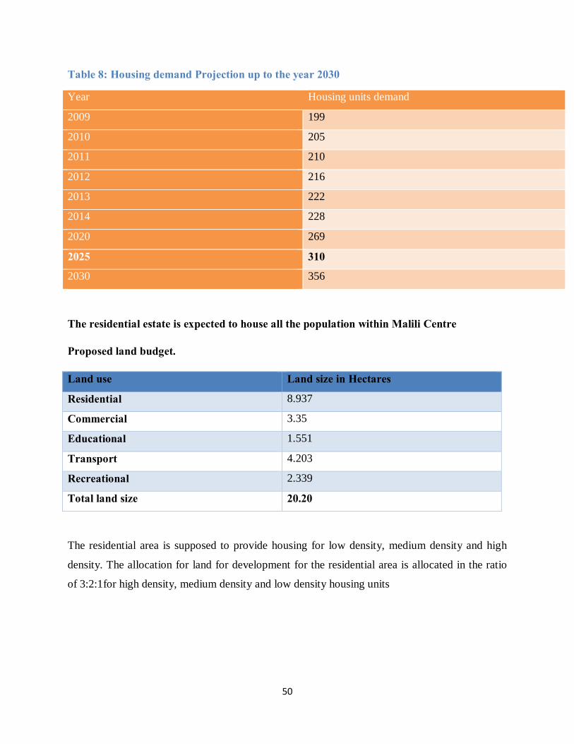
50
Table 8: Housing demand Projection up to the year 2030
Year Housing units demand
2009 199
2010 205
2011 210
2012 216
2013 222
2014 228
2020 269
2025 310
2030 356
The residential estate is expected to house all the population within Malili Centre
Proposed land budget.
Land use Land size in Hectares
Residential 8.937
Commercial 3.35
Educational 1.551
Transport 4.203
Recreational 2.339
Total land size 20.20
The residential area is supposed to provide housing for low density, medium density and high
density. The allocation for land for development for the residential area is allocated in the ratio
of 3:2:1for high density, medium density and low density housing units

51
Table 9: Adopted design standards
Land use Land size in Hectares
Plot coverage
Housing typology No. of floors
Total dwelling units
Other provision
Residential low density with circulation
3.738 50% Bungalow 48 Water and sewer system Landscaping Parking
Residential medium densitywith circulation
1.551 50% Maisonettes 1 110 Water and sewer system Landscaping Parking
Residential high densitywith circulation
3.648 50% Apartments 4 240 Water and sewer system Landscaping Parking
Educational 1.804 50% Row houses Classrooms Playgrounds
Recreational 2.339 Landscaping
Commercial 3.35 75% Apartments 4 Parking Market stalls
Transport Road name Road reserve Provisions
Nairobi Mombasa highway
60m Pedestrian walk ways Cycle paths Landscaping
Malili- Ulu 60m Pedestrian walk ways Cycle paths Landscaping
Internal circulation
12m Pedestrian walkways Traffic calming
Street Landscaping
Source Author, 2014

52
Plate 9: Conceptual Design
Source Author, 2014

53
Figure 3: Preliminary design of the Proposed Residential Area
The conceptual design shows how the various land uses will be located on the project site. The following land uses were considered, residential commercial, recreational, educational and transportation.

54
Figure 4: Final design
Source: Author 2014

55
Figure 5: site plan for the adopted alternative
Low Residential Zone
Housing typology is Bungalow
The streets are landscaped
Parking is within the residential area
Educational zone
Recreational Zone
Recreational Zone
High Density Residential Zone
Medium Density Residential Zone
Commercial Zone
Educational Centre
High Density residential
Medium Density
Medium Density
Recreational Area

56
Figure 6: 3D representation of the whole estate

57
4.2.3. Implementaton schedule
4.2.3.1. Project phasing The project will be implemented in 9 phases. Various components of the project are grouped
together and implemented together thus constituting the components of a phase. The project
implementation phases are as follows:
Phase Activity Short
Term
Long
Term Phase 1 Land acquisition and consolidation 9 months
Phase 2 Preparation of various plans and designs and submission of the same for approval
12 months
Preparation of an environmental impact assessment report for the site
3 months
Phase 3 Construction of a decanting site and relocation of residents to allow for site preparation
6 months
Phase 4 Preparation and organization of the site for the construction 3 months
Phase 5 Laying out and provision of transport infrastructure for the site. 30 months
Phase 6 Construction of the residential structures and installation of utility services
48 months
Phase 7 Construction of the shopping complex 21 months
Phase 8 Construction of early child development center 18 months
Phase 9 Landscaping and site beautification 15 months
4.3.2.2. Project time frame The project is estimated to take 48 months (4 years) from start to completion. In the project time
frame the project duration is divided into intervals of 3 months or a quarter (Q) and various
activities spread within this time frame. The project time frame is summarized in the table below.

58
Table 10: Project implementation time frame
2014 2015 2016 2017 2018
Programme Q1 Q2 Q3 Q4 Q5 Q6 Q7 Q8 Q9 Q1
0
Q11 Q12 Q13 Q14 Q15 Q16
Design of project
Project approval
Environmental Impact Assessment
Land acquisition
Tendering and of contractors
Establishment of security check
points
Residential housing construction
Construction inspection and approvals
Construction of circulation roads
Laying down of water and sewer
reticulation system.
Construction of Shopping Mall
Construction of ECD Center
Landscaping
Monitoring and evaluation

59
4.2.3.3. Project costing
The costs stated above are estimates based on the current markets prices for the provision of the
various activities. The costs are subject to change according to the changing economic trends and
the actual calculation of the costs by the relevant implementation agencies.
Activity Amount
Kshs. Cts.
Design of project 1,000,000
Project approval 50,000
Environmental Impact Assessment 10,959,150
Land acquisition 750,000,000
Residential housing construction 10,000,000,000
Construction inspection and approvals 100,000
Construction of circulation roads 4,000,000
Laying down of water and sewer reticulation system. 1,500,000
Construction of Shopping complex 200,000,000
Construction of ECD Center 1,500,000
Landscaping 1,000,000
Total cost 10,970,109,150

60
4.2.3.4. Implementation agencies and their roles in the project implementation Actors/Implementing
Agency
Roles
Director of Physical Planning Pursuant to Physical Planning Act Cap 286 is required to prepare
the redevelopment/renewal plan required for this project
Minister of Lands, Housing
and Urban Development
Required by law to approve the renewal plan prepared by the
director of physical planning
The department of housing will be required to work hand in hand
with the developers in ensuring the provision of a range of
affordable housing typologies
National Land Commission Pursuant to the constitution and national land commission act of
2012 is required to monitor and have an oversight responsibility
over land use planning in the country and by extension in the Malili
project.
County Government of
Makueni
Responsible for providing supporting laws and regulations for the
redevelopment of the estate
Will oversee the approval of the development plans and designs of
the proposed redevelopment plan of Malili Centre
Housing Estate
Mandated by law to oversee the implementation of this project
Revenue collection
Site management (garbage collection and clean ups)
Preparation/formulation of policy guidelines for similar old
institutional housing estates

61
NEMA In charge of environmental sustainability of the project i.e.
approval of the environmental impact assessment reports and
continuous monitoring of the project to ensure compliance
Private Investors and other
Development Partners
Will be an important source of funds for the construction works
Will further invest in various components of the estate
Area/estate residents Will be required to offer both skilled and unskilled expertise inform
of labour and ideas to realize the project
KOTDA This authority is mandated to control all developments within the
Konza City buffer zone where Malili Centre is located. It will be
responsible for development approval and control within the area.
Expected Outputs v Expected Outcomes
A pleasant living
and working
environment
v Construction of modern housing and commercial facilities
v Provision of a range of affordable housing typologies
v Efficient water reticulation system
v Proper waste disposal mechanisms
v Environmental conscious residential area
v Enhanced quality of life
v Well secured residential area
v Proper working environment
v Provision of basic street infrastructure
High density mixed
use developments
v 4 storey apartments
v well-integrated commercial and residential land uses

62
Generation of
employment
v Massive investments in the area
v Establishment of intra and inter trade linkages for the estate
High quality
landscape
v Well-designed external spaces
v A well-integrated natural and built environment
v Improved tree and green cover
v Improved landscaping and environment aesthetic
Institutional reform v Enhanced roles of County Government of Makueni in offering the
required services to the estate
v Proper articulation of the duties and responsibilities of the
KOTDA is development control and approval within the estate.

63
CHAPTER 5: EVALUATION AND MONITORING. Monitoring of a project is a cyclic process aimed at ensuring the project meets the guiding
objectives. The project’s ability to satisfy the specific needs it aimed to is evaluated during this
process. This process will be carried within a certain interval after the commencement of the
projects. There various observables to monitors during the projects life time.
5.1. Monitoring and Evaluation Stages of the Implemented Development Project Monitoring of the project will be done by a special committee with representatives from the
various stakeholders within the project. The committee will be guided a well laid down
framework. This committee then advice and propose changes that will guide the project to meet
its intended objectives.
5.1.1. Steps in monitoring and evaluation of the project. 1. Indicator selection
This involved creation of a framework for evaluation by use of project objectives and
expected outputs.
2. Validating indicators with stakeholders
This involves briefing of the stakeholders on the project time frame and expected
outcomes
3. Baseline assessment
4. Target and scale
Will entail formulation of targets in every stage of project implementation and time
frame.
5. Monitor inputs, outputs and short-term outcomes
This stage will evaluate the project short term goals and targets. This will ensure
continuous assessment of the project and ensure project implementation is on course.
6. Stakeholder consultation
This stage will ensure that stakeholders are updated on the status of the project and
allowed to give their advice on ways of improving project implementation.
7. Project adjustment

64
This will entail incorporating changes on the project implementation to ensure the project
meets its short term goals and targets.
8. Long term impact evaluation
At this stage of monitoring every phase of the project is evaluated to ensure that long
term goals are on course
9. Reporting and stakeholder engagement on project impact.
This stage will ensure documentation of the procedures of implementation process and
ensuing stakeholders are updated on the project status.
Figure 7: Summary of evaluation and monitoring stages
Indicators creation
Indicator validation by stakeholders
Baseline assessment
Set target and scale
Monitor inputs, outputs and short term
outcomes
Stakeholder consultation on
monitoring results
Project adjustments
Project evaluation – long term outcomes
Reporting and stakeholder engagement
on project impact

65
Monitoring and Evaluation Strategy
Expected out puts Indicators of a successful project Time period of
monitoring and
evaluation
Provision of a variety of
housing typologies
Attraction of different economic groups to reside
in the estate
Yearly
Increased accessibility
and integration within the
neighborhood
Commercial unit, educational Centre,
recreationalfacility easily accessible to all
Yearly
A proper layout and
refurbished neighborhood
Comfortable and engaging environment. After every 6
months
Vibrant and lively neighborhood Yearly
Source: Author, 2014
5.2. Guidelines for the Implementation Process The project evaluation will guided by the adopted guidelines for the project area illustrated in
table 7. The guiding principles for the project implementation and evaluation are:
1. Compactness/distinct urban form
2. Connectivity/accessibility/circulation
3. Livability
4. Environmental sustainability
5. Compatibility
6. Health, safety and efficiency
7. Optimum, efficient and economical utilization of space
8. Inclusive and coordination of governance

66
5.3. Site Management Plan The implementation of the project will be will result in some negative impact on the existing site
and environment. There is thus a need to develop a site management plan for the project area.
This plan will aim at mitigating the negative impacts by proposing measures that will reduce the
effects of the negative impacts. The proposed measures are summarized in the table below.
Table 11: Site management Plan
Expected
Environmental
impact
Activity Mitigation measures
Generation of
construction waste
Site clearance and construction
Making available suitable facilities for the collection, segregation and safe disposal of the wastes by:
v Installing waste receptacles for waste collection during operation
v Having a sound waste collection plan
Fill any depression to bring about leveling to promote landscaping
Loss of Flora Site clearance:
removal of
vegetation
Appropriate planting of trees and flowers incorporated in design stage to protect buildings and boost
boundary safety
Cutting of mature trees only when necessary
Incorporating natural vegetation in the design
Noise Site clearance and construction Buffering of the site using iron sheets through the screening process
Construction works to be limited to day time only Using equipment with noise suppressing
technologies.
Providing workers with ear plugs.
Dust nuisances Site clearance and construction Ground watering and screening to suppress the dust.

67
Emission of Air
Pollutants
Use of fossil fuel engines
vehicles, generators, water pumps.
Using clean fuels such de-sulphureted diesel and unleaded fuels.
Use of filtering masks
Safety and
security
Construction and occupation Access should be restricted to workers during site clearance and construction
The access control to be strictly adhered to during operation/occupation
Source: Author, 2013

68
REFERENCES
DPP (2010), “Konza LPDP 2012-2030.” Director of Physical Planning, Nairobi 2013, Director
of Physical Planning
GoK (1996), Physical Planning Act cap 286. Government printers: Nairobi.
GoK (1999), Environmental Management and Coordination Act. Government printers: Nairobi
GoK (2004), National Housing Policy. Government printers: Nairobi.
GoK (2010), Constitution of Kenya. Government printers: Nairobi.
GoK (2011), Urban Areas and Cities Act 2011. Government printers: Nairobi.
GoK (2012), The County Government Act 2012.Goverment printers: Nairobi.
Ministry of Lands and Settlements, GoK. (2002). Physical Planning Handbook. Nairobi: Kenya
Ministry of Lands and Settlements, GoK. (2008). Physical Planning Handbook. Nairobi: Kenya
National planning and building authority, GoK (2009) Planning and Building Regulations. Government printers: Nairobi
69
Appendix