recommended improvements to the southwest corridor path
TRANSCRIPT

Recommended Improvements to the Southwest Corridor Path Intersections
Transportation Capstone Class of 2009 Advisors: Peter Furth & Dan Dulaski
January-February 2009

Table of Contents Treatments Manual
Introduction…………………………………………………………………………………………………………………………………………1 Curb Cuts……………………………………………………………………………………………………………………………………..…....4 Unsignalized Midblock Crossings………………………………………………………………………………………………………………5 Unsignalized Intersections……………………………………………………………………………………………………………………….6 Signalized Intersections…………………………………………………………………………………………………………..……………...7 Shared Sidewalks………………………………………………………………………………………………………………………………….8 Destination Signage……………………………………………………………………………………………………………………………….9 Path Signage & Pavement Markings…………………………………………………………………………………………………………12 Vehicular Signage & Pavement Markings…………………………………………………………………………………………………..15 Sign Schedule……………………………………………………………………………………………………………………………………..19 Pavement Markings Schedule…………………………………………………………………………………………………………………20 Cost-Priority Matrix……………………………………………………………………………………………………………………………...21 Quantity Table…………………………………………………………………………………………………………………………………….23
Intersection Analysis
West Newton Street Recommendations……………………………………………………………………………………………………..24 Massachusetts Ave Recommendations………………………………………………………………………………………………………26 Camden Street Recommendations……………………………………………………………………………………………………………28 Melnea Cass Blvd. Recommendations……………………………………………………………………………………………………….30 Ruggles Street Recommendations……………………………………………………………………………………………………………32 Prentiss Street Recommendations……………………………………………………………………………………………………………34 Tremont Street Recommendations……………………………………………………………………………………………………………36 New Cedar Recommendations…………………………………………………………………………………………………………………38 Heath Street Recommendations………………………………………………………………………………………………………………40 Centre Street Recommendations……………………………………………………………………………………………………………..42 Atherton Street Recommendations…………………………………………………………………………………………………………..44 Boylston Street Recommendations…………………………………………………………………………………………………………..46 New Minton Street Recommendations……………………………………………………………………………………………………...48 Green Street Station Recommendations…………………………………………………………………………………………………...50 Williams Street Recommendations…………………………………………………………………………………………………………..52 McBride Street Recommendations…………………………………………………………………………………………………………..54 New Washington Street Recommendations………………………………………………………………………………………………..56 Washington Street Recommendations……………………………………………………………………………………………………...58
NU Transpos Northeastern University
Boston, Massachusetts 10 February 2009 Southwest Corridor Park Parkland Management Advisory Committee Boston, Massachusetts Attention: Mr. Jeffrey Ferris Cc: Professor Daniel Dulaski and Professor Peter Furth
Northeastern University Subject: Report on Recommended Improvements for Bicycle Path Intersections
Southwest Corridor Park Boston, Massachusetts Ladies and Gentlemen: This report summarizes the work completed by 15 Northeastern University Students regarding safety improvements along the Southwest Corridor Park Bicycle Path in Boston, Massachusetts. The work was undertaken in response to a request from the Southwest Corridor Park Parkland Management Advisory Committee (PMAC). This work was part of a project for the Transportation Engineering Senior Capstone course in the School of Engineering’s Civil and Environmental Engineering department. The students of this class, referred to as NU Transpo, all have educational backgrounds, and many have job experience, in the field of transportation engineering. Students worked in teams of 3 or 4 that focused on a section of the path consisting of 4 or 5 intersections. Teams conducted field visits to observe the existing conditions and document issues and areas for improvement. Each team met individually and prepared a design for their intersections addressing these issues and areas for improvement. Group coordinators worked together to ensure that each team’s reports could be assembled to prepare this final report and to ensure that each team’s design followed uniform code. It is our opinion that the recommendations made in this report would greatly improve the safety of the Southwest Corridor bicycle path for pedestrians, bicyclists and drivers at the intersections. We are pleased to submit this report and welcome any questions or comments. Regards, NU Transpo ‘09
1

Introduction The Pierre Lallement Southwest Corridor Park is a 4.7 mile separated bicycle and pedestrian path in Boston, Massachusetts. This path runs alongside the MBTA Orange Line tracks between Forest Hills Station and Back Bay Station. Established in May 1987 as a 52-acre linear park, the Southwest Corridor has become a frequently used bike path for the people of the Commonwealth, albeit most of them are bicycle commuters. Despite the popularity of the bicycle path for commuters in Boston, it is rarely used for recreational purposes. Promoting this park as a place for recreation and escape from the “big city” has been minimal to date. Bicycle riding is an increasingly popular trend today. In response to rising fuel costs and environmental awareness movements, more and more people are commuting via bicycle and using the bicycle for recreation and exercise. Also, anticipated revisions to the Manual on Uniform Traffic Control Devices (MUTCD) Part 9 – Traffic Controls for Bicycle Facilities have shown that engineers are taking bicycling more seriously. These factors have caused an increased awareness amongst professionals regarding the concern, need and means for safety along bicycle travel paths and lanes that interact and intersect with pedestrian and vehicular travel areas. Safety improvements along the Southwest Corridor Park may also play a large role in promoting the park’s use by simultaneously making it a more appealing area for people to visit. Regular users of the path have voiced their concern over the safety of several intersections of the path with vehicular roadways. Users cite the lack of signage, obstructed sight lines and poor maintenance as the primary factors that make such intersections unsafe. Discussions with PMAC representatives revealed these same concerns.
2

Field visits conducted by NU Transpo corroborated the concerns of path users and PMAC representatives. Field visits also revealed a number of other existing conditions that may play roles in creating unsafe intersections along the path’s alignment. Recommendations for improvements were developed in response to all of the identified areas of safety concern. Many of the intersections require unique improvements due to the general nature of the park and path, which travels from a residential area, Forest Hills Station, into the dense city at Back Bay Station. Conceptual designs for improvements were prepared in accordance with the Manual on Uniform Traffic Control Devices (MUTCD), the Standard Highway Signs, The Massachusetts Amendments to the Manual on Uniform Traffic Control Devices and the Standard Municipal Traffic code and the Driver’s Manual for Bicyclists. For each intersection along the bicycle path there is a report and recommended improvements plan. The reports summarize the existing conditions and areas for improvement as well as the recommended improvements. The uniqueness of each intersection was determined to be such that each intersection presents a new set of areas for improvement and requires a unique set of recommendations. Although each intersection has its own report, several standards regarding many of the recommended improvements were developed to ensure design continuity and that each intersection received a series of minimal improvements that were deemed high priority and low cost. The following is a Treatment Manual that describes these standards, presents a Sign Schedule and a Cost-Priority matrix.
3

Curb Cuts Standard Design Criteria Function: The curb cuts along the Southwest Corridor Path are not consistent or adequate at many crossings. With improvements to the transitions from the shared use path to the crosswalks the path will provide better flow and minimize conflict between users. Form: Due to the frequency of having 2 bikes crossing at these locations we determined 78 inches as the minimum dimension for all curb cuts along the path. We chose 78 inches as the minimum so two cyclists can pass each other while on the ramp with ease. See figure 1.1 for the operating width of one cyclist. MassHighway and AASHTO recommend that the curb cut width be at least the width of the path. Due to the SWCP having both a 4-6 foot pedestrian path and an 8-10 foot bike path which merge when approaching a crossing, we chose 120 inches to be the ideal dimension of all curb cuts where it is feasible. At the locations where 120 inches is not feasible the largest width feasible will be implemented not less than 78 inches.
Figure 1.1
4

Midblock Crossing Standard Design Criteria Midblock crossings should function as a small street meeting a main street for bicycles and vehicles. The following design criteria address the issues that arise on the midblock crossings along the Southwest Corridor.
Crosswalks - Crosswalks should be of the ladder painted type, with minimum width of 10 ft. Many of the crosswalks along the length of the path are too narrow for passing cyclists, therefore this minimum width is recommended. Curb Cuts – Curb cuts should be of a minimum 78 in wide, but ideally these curb cuts will be 120 in wide to match the crosswalk width and increase comfort for all users. Path Signage – Add sign SP-1 to back of bollard warning passing bicyclists of merger (SP-1 was designed for this project, see details in Appendix A). Many cyclists cannot see the pedestrians at mergers due to trees between the bicycle and pedestrian path, therefore it is recommended that sign SP-1 be installed. To promote use of the path and inform potential users of the destinations reached by the path, it is recommended that signs FH-1 and BB-1 be installed. Vehicular Signage – Add signs W11-15, W11-15P. Drivers do not appear to be cautious of the path crossing at many intersections; therefore it is recommended that signs W11-15 and W11-15P be installed at each intersection. Pavement Markings – Add dashed centerline painting along length of bicycle path. Add pedestrian legend to pedestrian path and bicycler legend to bicycle path. To promote safety and ensure that cyclists always travel in the right lane of the path, it is recommended that a dashed centerline be painted along the length of the bicycle path. To ensure that this does not present confusion for those traveling along the path, it is recommended that a pedestrian symbol and bicyclist symbol be painted on their respective path on both sides of each crossing. Yield – Due to the poor sight line visibility for both bicyclists and drivers at all of the midblock crossings we recommend adding yield signs (R1-2) and yield pavement markings to the bicycle approach. We observed that bicyclists typically yield and adding yield signs and pavement markings will only reinforce the current behavior. This will eliminate the confusion of who has to yield and prevent drivers from yielding to something they cannot see. *Please see Figure 6 for a standard design as applied to Prentiss Street.*
5

Unsignalized Intersections
Function: The intended behavior of unsignalized intersections is to make vehicles stop for pedestrians and bicyclists using the path. Major streets at intersections crossing the path shall be allowed free movement without stopping unless the path crosses the major street. All minor streets should stop before the intersection or crosswalks. Form: Unsignalized intersections should use the following elements to create a safe, harmonizing design for path users: • Stop lines will be placed 10 ft. before crosswalks to prevent cars from blocking crosswalks. • Crosswalks will be a minimum of 10 ft. wide. The ladder style crosswalk will be used • Curb cuts will remain unchanged if the current width is more than 66 in. Otherwise the curb
cuts will be reconstructed to a minimum of 78 in. An ideal width of 120 in. can be used if feasible.
• Warning signs alerting vehicles of path crossings will be placed on all vehicle approaches. W11-15 and W11-15p will be installed on both approaches of streets the path crosses. TW signs will be placed on approaches which vehicles must turn to cross the path.
• Destination signs, BB-1 and FH-1, will be added at intersections to promote path usage. • Pavement markings on the path shall consists of the bicycle and pedestrians legends along
with a dashed center line for the bicycle path. For visual reference, please see Figure 16.
6

Signalized Intersections
Function: The intended behavior of signalized intersections is to allow pedestrians and bicyclists using the path to experience maximum green. This is accomplished by adjusting the intersection phasing plan so that all pedestrian and bicycle movements are made to be automatic and concurrent. Form: Signalized intersections should utilize the following elements to promote a safe and efficient design for path users: • No Turn on Red Signs will be placed on all approaches with potential right turning conflicts
with path users. R10-11B signs will be installed at the stoplines of all approaches described above. The implication of No Turn on Red for all conflicting approaches should mitigate blocked crossing scenarios for path users.
• Protected left Turns within a phase will be used instead of permitted left turns to eliminate potential left turning conflicts with path users.
• Concurrent pedestrian phases will be preferred in signal timing plans. Intersections with high pedestrian volumes (such as Boylston Street, Figure 12) will utilize concurrent pedestrian phasing rather than exclusive pedestrian phases
• Leading pedestrian intervals will be used for all timing plans with concurrent pedestrian phases. Path users will be given a walk signal 3 seconds before the concurrent vehicular green is displayed.
• No Pushbuttons will be used at signalized intersections as pedestrian intervals will be automatic and concurrent.
For visual reference, please see Figure 12.
7

Shared Sidewalks The separation of pedestrians and cyclists along shared crosswalks remains as an issue that many people encounter. Concerns are raised as sidewalk users attempt to bypass one another without interfering with another user’s path. It is necessary to establish a system where pedestrians and cyclists can easily identify their own travel way and create a systematic and hassle free environment. A method for approaching this situation is to create a distinct bike path that pedestrians will reserve for bicyclists only and to be mindful when crossing over. This bike path will required a sectional cut in the sidewalk where white bricks will outline the edges of the path and the space in between to be filled with asphalt. In addition, a centerline will be painted to split directional use of the bike path and bicycle silhouettes will also be painted to alert pedestrians of the path’s purpose. The bike path is be set at a minimal width of seven feet to comfortably accommodate bicycles travelling in opposite directions. The purpose of the bike path is to create a safe and reliable route that upholds the key concept of segregating pedestrian and bicycle use on sidewalks. It is expected that pedestrians will keep off the bike path at all times unless crossing and if so, pedestrians will look for oncoming bicycles. In the case where people or obstructions are in the bike path making it impossible for bicycles to pass through, bicyclists are allowed to ride on the sidewalk until they can safely return onto the path. Such implementations of the bike path will reflect compliance as pedestrians will feel estranged walking on the path knowing that it is designed for bicycle use and by switching from a concrete, granite, or brick sidewalk to an asphalt surface.
8
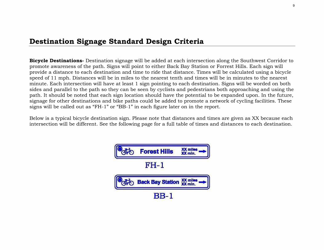
Destination Signage Standard Design Criteria Bicycle Destinations- Destination signage will be added at each intersection along the Southwest Corridor to promote awareness of the path. Signs will point to either Back Bay Station or Forrest Hills. Each sign will provide a distance to each destination and time to ride that distance. Times will be calculated using a bicycle speed of 11 mph. Distances will be in miles to the nearest tenth and times will be in minutes to the nearest minute. Each intersection will have at least 1 sign pointing to each destination. Signs will be worded on both sides and parallel to the path so they can be seen by cyclists and pedestrians both approaching and using the path. It should be noted that each sign location should have the potential to be expanded upon. In the future, signage for other destinations and bike paths could be added to promote a network of cycling facilities. These signs will be called out as “FH-1” or “BB-1” in each figure later on in the report. Below is a typical bicycle destination sign. Please note that distances and times are given as XX because each intersection will be different. See the following page for a full table of times and distances to each destination.
9

Pedestrian Destinations- On the Southwest Corridor, Camden Street contains a stretch where the bicycle path and pedestrian path are not adjacent. During this stretch, it may not be obvious to pedestrians that they are using the Southwest Corridor. At this location, pedestrian destination signs shall be added to increase awareness of the path. Signs will be the same as bicycle destinations signs except will have a pedestrian symbol instead of a bicycle and contain only the distance to each destination. These signs will be called out as “FH-2” or “BB-2” in each figure later on in the report. Below is a typical pedestrian destination sign.
10

Please see the following for a distance table for Camden Street: Bicycle Destination Signage Table Distance & Time Calculations
To Back Bay
Station To Forest
Hills Cross Street Miles Minutes* Miles Minutes
West Newton St. 0.3 2 3.6 20 Mass Ave. 0.6 3 3.3 18
Camden St. 0.7 4 3.2 18 Melnea Cass Blvd. 1.1 6 2.8 15
Ruggles St. 1.2 7 2.7 15 Prentiss St. 1.4 8 2.5 14 Tremont St. 1.6 9 2.3 13
New Cedar St. 1.8 10 2.1 12 Heath St. 2.1 12 1.8 10
Centre St. 2.3 13 1.6 9 Atherton St. 2.5 14 1.4 8 Boylston St. 2.7 15 1.2 7
New Minton St. 2.9 16 1.0 6 Green/Gordon St. 3.2 17 0.7 4
Williams St. 3.4 19 0.5 3 McBride St. 3.6 20 0.3 2
New Washington St. 3.9 21 - - Washington St. 4.0 21 - -
*All times calculated using a speed of 11 m.p.h.
11

Path Signage and Markings Path signage and markings need specific treatment along the Southwest Corridor. The following subsections address the specific treatments needed. Please note that any path treatments are the Department of Conservation responsibility. Standard design criteria were obtained using the Manual on Uniform Traffic Control Devices (MUTCD) – FHWA 2003 Edition or the 2003 Highway Capacity Manual (HCM).
Path Merge Sign – Section 2C.31 Merge Signs in the 2003 MUTCD Edition states “A Merge sign may be used to warn road users on the major roadway that merging movements might be encountered in advance of a point where lanes from two separate roadways converge as a single traffic lane and no turning conflict occurs.” See appendix A for details regarding path merge sign (SP-1). Yield Placement – Section 3B.16 Stop and Yield Lines in the 2003 MUTCD Edition states that “if used, yield lines (see Figure 3B-14) shall consist of a row of solid white isosceles triangles pointing toward approaching vehicles extending across approach lanes to indicate the point at which the yield is intended or required to be made.”
Figure 3B-14 Examples of Yield Line Layouts
The individual triangles comprising the yield line should have a base of 300 to 600 mm (12 to 24 in) wide and a height equal to 1.5 times the base. The space between the triangles should be 75 to 300 mm (3 to 12 in).
12
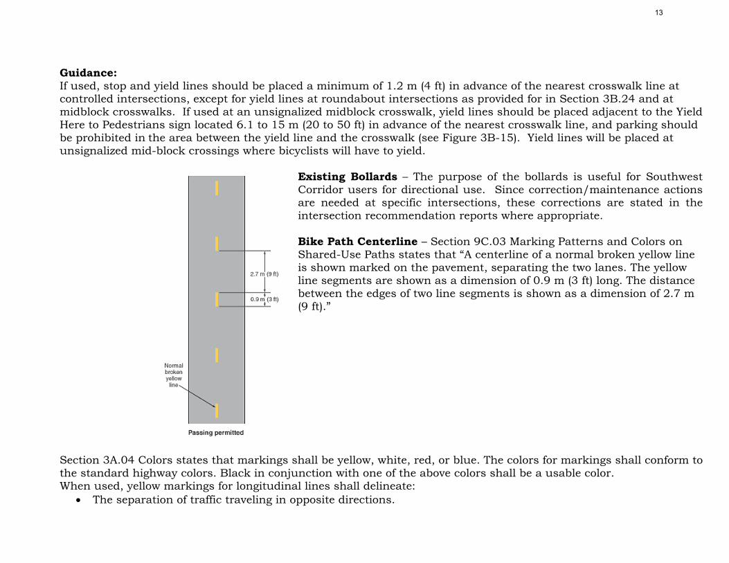
Guidance: If used, stop and yield lines should be placed a minimum of 1.2 m (4 ft) in advance of the nearest crosswalk line at controlled intersections, except for yield lines at roundabout intersections as provided for in Section 3B.24 and at midblock crosswalks. If used at an unsignalized midblock crosswalk, yield lines should be placed adjacent to the Yield Here to Pedestrians sign located 6.1 to 15 m (20 to 50 ft) in advance of the nearest crosswalk line, and parking should be prohibited in the area between the yield line and the crosswalk (see Figure 3B-15). Yield lines will be placed at unsignalized mid-block crossings where bicyclists will have to yield.
Existing Bollards – The purpose of the bollards is useful for Southwest Corridor users for directional use. Since correction/maintenance actions are needed at specific intersections, these corrections are stated in the intersection recommendation reports where appropriate. Bike Path Centerline – Section 9C.03 Marking Patterns and Colors on Shared-Use Paths states that “A centerline of a normal broken yellow line is shown marked on the pavement, separating the two lanes. The yellow line segments are shown as a dimension of 0.9 m (3 ft) long. The distance between the edges of two line segments is shown as a dimension of 2.7 m (9 ft).”
Section 3A.04 Colors states that markings shall be yellow, white, red, or blue. The colors for markings shall conform to the standard highway colors. Black in conjunction with one of the above colors shall be a usable color. When used, yellow markings for longitudinal lines shall delineate:
• The separation of traffic traveling in opposite directions.
13

• The left edge of the roadways of divided and one-way highways and ramps. • The separation of two-way left turn lanes and reversible lanes from other lanes.
Pedestrian and Bike Silhouettes – Section 9C.07 Bicycle Pavement Marking states “a vertical symbol of a person wearing a helmet riding a bicycle with a vertical line segment above the symbol and one below it. The length of each vertical line segment is shown as a dimension of 150 mm (6 in). The distance from the bottom of the line segment above the symbol to the top of the symbol is shown as a dimension of 125 mm (5 in). The overall length of the symbol is shown as a dimension of 600 mm (24 in). The distance from the bottom of the symbol to the top of the vertical line segment below it is shown as a dimension of 50 mm (2 in).” A pedestrian symbol will also be used on the path. The figure will be the same as a pedestrian walk symbol used for street crossings but painted onto the pavement. The dimension and size will be consistent with Section 9C.07 for Bicycle Pavement Marking.
Cobblestones in bike path – The removal of cobblestones where the pedestrian and bike paths merge shall be completed at every intersection. The existing cobbles serve no value, they are difficult to maintain and are a hazard to cyclists.
14

Vehicular Signage and Markings • No Turn on Red – Add “No Turn on Red” sign in line with stop line to prevent drivers from stopping in
the crosswalk at the East leg of New Cedar Street.
Source: 2B.45, MUTCD, 2003, http://mutcd.fhwa.dot.gov/HTM/2003r1/part2/fig2b-19_longdesc.htm
• Stop here on Red – Drivers have been observed stopping past the stop line and in the crosswalk at Ruggles Street, Roxbury Crossing, Heath Street, and Centre Street; hence, it is recommended to install “Stop here on Red” in line with existing stop line at mentioned intersection. In addition, realign “Stop here on Red” sign with stop line on New Cedar Street.
Source: 2B.45, MUTCD, 2003, http://mutcd.fhwa.dot.gov/HTM/2003r1/part2/fig2b-19_longdesc.htm
15

• Trail crossing ahead – Trail Crossing ahead should be placed at all intersection where crossing is unclear and ambiguous to drivers. It is recommended to install non-vehicular Traffic Signs (W11-15) and Supplemental Warning Plaques (W11-15p) at each intersection where recommended. MUTCD does not suggest a set back distance for sign (W11-15) or (W11-15p), therefore,
NU Transpo has evaluated to set these signs in line with the crosswalks for all intersections except Prentiss Street.
Nonvehicular Traffic Sign and Supplemental Warning Plaque of Prentiss Street are recommended to be advanced 300’ from the crosswalk due to the poor sightline on the horizontal alignment on the east leg of the intersection. In addition, “TRIAL XING” Supplemental Warning Plaque will be replaced by the “300 FT” only for this intersection.
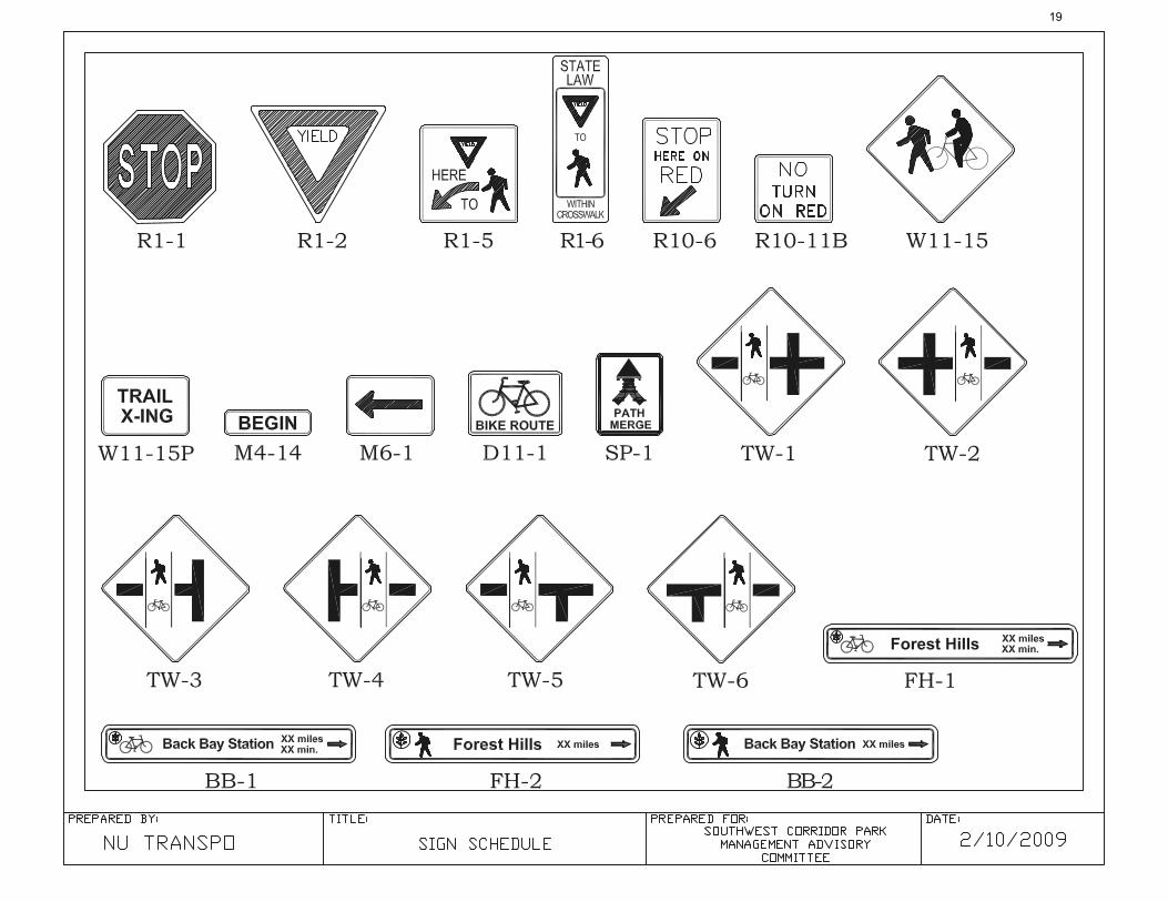
(Refer SIGN SCHEDULE for sign details)
• In-street “Yield to Peds” – Poor sight distance for vehicles at West Newton Street causes a danger to cyclists and pedestrians approaching the crosswalk. It is recommended to install an Unsignalized Pedestrians Crosswalk Sign in the middle of the intersection during non-snow conditions.
Source: Section 2B.11, MUTCD, 2003, http://mutcd.fhwa.dot.gov/HTM/2003r1/part2/part2b1.htm#section2B08
16

• Yield Line – It is recommended to install Yield Line on West Newton Street consisting of In-street “Yield
to Peds” sign. Referring to MUTCD Section 3B, Guidance “If used at an unsignalized midblock crosswalk, yield lines should be placed adjacent to the Yield Here to Pedestrians sign located 6.1 to 15 m (20 to 50 ft) in advance of the nearest crosswalk line, and parking should be prohibited in the area between the yield line and the crosswalk .”
Source: Section 3B, MUTCD, 2003, http://mutcd.fhwa.dot.gov/HTM/2003r1/part3/part3b2.htm#section3B16
• Crosswalk Style – All crosswalks should be of the ladder painted type, with minimum width of 10 ft.
Ladder style crosswalk provides better visibility to drivers at unsignalized locations, such as mid-block crossing. Repaint ladder style crosswalk – Ruggles Street, Prentiss Street, New Cedar Street, and Heath Street
• Crosswalk location – All crosswalks should be in line with curb cuts and paths.
Add new crosswalks –Add crosswalks on Camden Street as recommended in Figure 3. Add a new crosswalk at east leg of William Street. Add an additional crosswalk on the west leg of Washington Street intersection to allow path users greater flexibility to cross New Washington Street.
Realign crosswalk with paths – Melnea Cass Blvd, Centre Street. Realign crosswalk with curb cuts – New Cedar Street, Atherton Street, Boylston Street, New Minton
Street, and New Washington Street.
17
Reconfigure the crosswalk – Reconfigure the crosswalk on Washington Street for travel along the east-west direction where the right hand turning lane is eliminated.
• Set-back stop lines – Stop lines should be a minimum of 10’ from edge of crosswalk at signalized
intersections, and its benefits include pedestrian comfort, visibility, and reduced chance of vehicles encroaching on crosswalks. Many vehicles at signalized path crossing stop past the stop line, often stopping in the crosswalk, therefore this minimum setback is recommended. Set-back stop lines – Ruggles Street, Roxbury Crossing, New Cedar Street, Heath Street, and
Boylston Street. Add stop lines from 10’ from edge of new/existing crosswalks – Green Street, Williams Street, and
McBride Street. Stop line on Centre Street is recommended to set back 50’ per crosswalk realignment.
[Neglect section of “Sign warning right-turning cars of trail” because no intersection is recommended.]
18
19

20
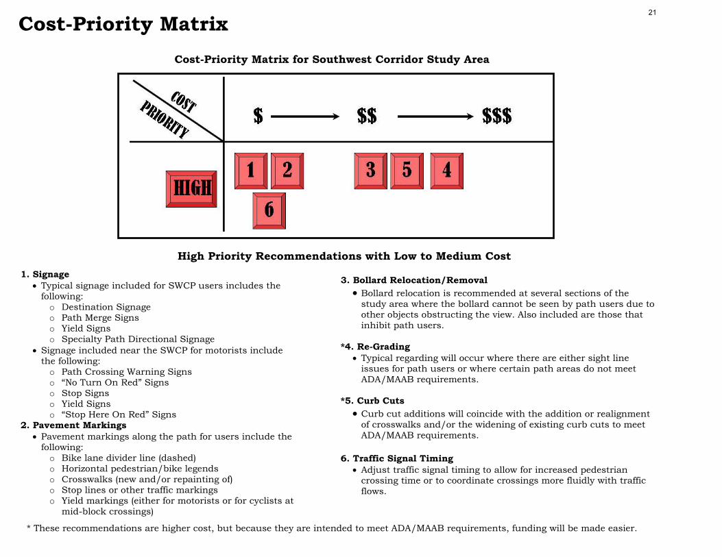
1. Signage
• Typical signage included for SWCP users includes the following:
o Destination Signage o Path Merge Signs o Yield Signs o Specialty Path Directional Signage
• Signage included near the SWCP for motorists include the following:
o Path Crossing Warning Signs o “No Turn On Red” Signs o Stop Signs o Yield Signs o “Stop Here On Red” Signs
2. Pavement Markings • Pavement markings along the path for users include the
following: o Bike lane divider line (dashed) o Horizontal pedestrian/bike legends o Crosswalks (new and/or repainting of) o Stop lines or other traffic markings o Yield markings (either for motorists or for cyclists at
mid-block crossings)
3. Bollard Relocation/Removal
• Bollard relocation is recommended at several sections of the study area where the bollard cannot be seen by path users due to other objects obstructing the view. Also included are those that inhibit path users.
*4. Re-Grading
• Typical regarding will occur where there are either sight line issues for path users or where certain path areas do not meet ADA/MAAB requirements.
*5. Curb Cuts
• Curb cut additions will coincide with the addition or realignment of crosswalks and/or the widening of existing curb cuts to meet ADA/MAAB requirements.
6. Traffic Signal Timing
• Adjust traffic signal timing to allow for increased pedestrian crossing time or to coordinate crossings more fluidly with traffic flows.
Cost-Priority Matrix for Southwest Corridor Study Area
Cost-Priority Matrix
High Priority Recommendations with Low to Medium Cost
* These recommendations are higher cost, but because they are intended to meet ADA/MAAB requirements, funding will be made easier.
21
7. Curb Extension
• Typical curb extensions will occur at places where travel lanes will be eliminated or where curb lines will be relocated to accommodate other recommendations, such as relocated crosswalks. This would also include any necessary signal relocation as well.
8. Sidewalk Changes
• Typical sidewalk change recommendations are included at major bus stop locations that, in some instances, coincide with heavy pedestrian traffic from nearby MBTA subway stations.
9. Steel Paneling
• Steel paneling that was previously installed has caused numerous sight line issues that have created conditions at intersections that are less than ideal. Recommendations include changing the opaque paneling that is currently installed to one that uses a plexi-glass (or similar) paneling to allow for increased visibility.
10. Maintenance Issues • Recommendations include the following (among others):
o Replace cobble transition strips or eliminate them where the SWCP approaches an intersection.
o Adjust granite blocks at locations where they have been moved out of place.
o Provide repaving of the SWCP at various locations where either tree roots have disturbed the path or where there is some other issue.
11. Gateway Signage
• Provide gateway signage at the start and end of the Southwest Corridor Path (and where appropriate elsewhere on path) to notify path users that they are entering the SWCP. Final design is to be addressed by others.
Cost-Priority Matrix for Southwest Corridor Study Area
Low to Medium Priority Recommendations with Higher Costs
Cost-Priority Matrix 22
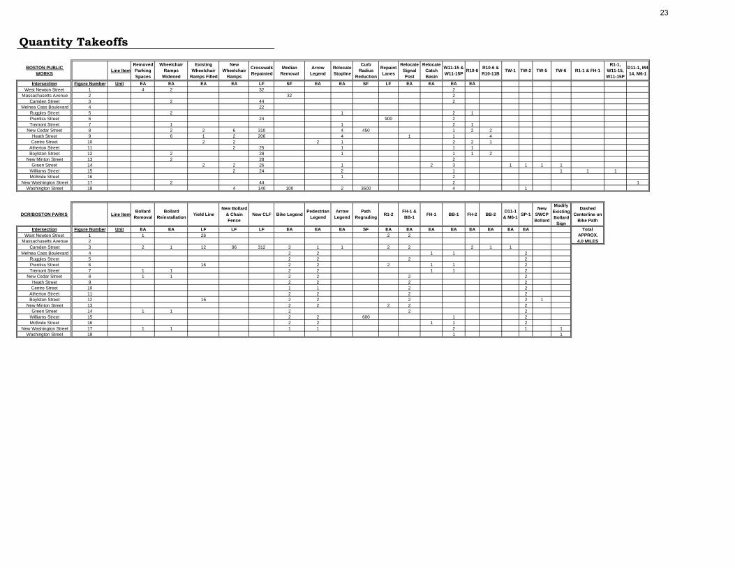
Quantity Takeoffs
BOSTON PUBLIC WORKS
Line ItemRemoved Parking Spaces
Wheelchair Ramps
Widened
Existing Wheelchair
Ramps Filled
New Wheelchair
Ramps
Crosswalk Repainted
Median Removal
Arrow Legend
Relocate Stopline
Curb Radius
Reduction
Repaint Lanes
Relocate Signal Post
Relocate Catch Basin
W11-15 & W11-15P
R10-6 R10-6 & R10-11B
TW-1 TW-2 TW-5 TW-6 R1-1 & FH-1R1-1,
W11-15, W11-15P
D11-1, M4-14, M6-1
Intersection Figure Number Unit EA EA EA EA LF SF EA EA SF LF EA EA EA EAWest Newton Street 1 4 2 32 2
Massachusetts Avenue 2 32 2Camden Street 3 2 44 2
Melnea Cass Boulevard 4 22Ruggles Street 5 2 1 2 1Prentiss Street 6 24 900 2Tremont Street 7 1 1 2 1
New Cedar Street 8 2 2 6 310 4 450 1 2 2Heath Street 9 6 1 2 206 4 1 1 4Centre Street 10 2 2 2 1 2 2 1
Atherton Street 11 2 25 1 1 1Boylston Street 12 2 28 1 1 1 2
New Minton Street 13 2 28 2Green Street 14 2 2 26 1 2 3 1 1 1 1
Williams Street 15 2 24 2 1 1 1 1McBride Street 16 1 2
New Washington Street 17 2 44 2 1Washington Street 18 4 140 100 2 3600 4 1
DCR/BOSTON PARKS Line ItemBollard
RemovalBollard
Reinstallation Yield LineNew Bollard
& Chain Fence
New CLF Bike LegendPedestrian
LegendArrow
LegendPath
Regrading R1-2FH-1 & BB-1 FH-1 BB-1 FH-2 BB-2
D11-1 & M6-1 SP-1
New SWCP Bollard
Modify Existing Bollard
Sign
Dashed Centerline on
Bike Path
Intersection Figure Number Unit EA EA LF LF LF EA EA EA SF EA EA EA EA EA EA EA EA TotalWest Newton Street 1 1 26 2 2 APPROX.
Massachusetts Avenue 2 4.0 MILESCamden Street 3 2 1 12 96 312 3 1 1 2 2 2 1 1
Melnea Cass Boulevard 4 2 2 1 1 2Ruggles Street 5 2 2 2 2Prentiss Street 6 16 2 2 2 1 1 2Tremont Street 7 1 1 2 2 1 1 2
New Cedar Street 8 1 1 2 2 2 2Heath Street 9 2 2 2 2Centre Street 10 1 1 2 2
Atherton Street 11 2 2 2 2Boylston Street 12 16 2 2 2 2 1
New Minton Street 13 2 2 2 2 2Green Street 14 1 1 2 2 2
Williams Street 15 2 2 600 1 2McBride Street 16 2 2 1 1 2
New Washington Street 17 1 1 1 1 2 1 1Washington Street 18 1 1
23

Issues: At the midblock crossing of the Southwest Corridor along W. Newton Street there are a few areas which may be hazardous to drivers, cyclists and pedestrians. Sight distance is a major issue for drivers on W. Newton St. and the poor alignment of the crosswalk crossing W. Newton St. with the ramps and bollards is a problem for pedestrians and bicyclists.
S o u t h w e s t C o r r i d o r C r o s s i n g W. N e w t o n St r e e t Findings: After conducting a series field visits to evaluate the crossing, the following issues were identified.
• Signage - No signage for drivers approaching
from either direction of W. Newton St. warning them of crossing.
- With very poor sight distance for both drivers and cyclists, the lack of sign-age is very dangerous.
• Intersection Geometry - Crosswalk aligns with the sidewalk
ramps, however, not with the bollards. - A large bollard is lined up directly with
the sidewalk ramp on the northern leg of the intersection.
- Ramps are only 3’6” wide. • Pavement/Path Marking
- Due to the many parked cars along W. Newton St., it becomes very difficult for pedestrians and cyclists on the corridor to see approaching cars as they cross.
- No pavement markings or signs are present to inform cyclists to yield for cars.
Recommendations (Figure 1): The following recommendations have been identified:
• Signage - Add signs for drivers at both
approaches of W. Newton St. to inform them of a pedestrian and bicyclist crossing.
- Place signs 30 feet before the crosswalk to give the drivers ample time to slow down and proceed with caution.
- Add a “Yield” sign on the bollards at both approaches of the bike path to slow down bicyclists.
• Intersection Geometry
- Remove the bollard that lies directly in front of the handicap ramp on the northern leg of the intersection.
- Increase ramp width to the standard 78”.
- Remove one parking spot on North side of W Newton Street to improve sightlines for bicyclists and signage.
• Pavement/Path Markings
- Add shark teeth pavement markings on both sides of the bike path as it approaches the intersection.
Southwest Corridor Looking Inbound
W. Newton St. Looking North Southwest Corridor at W. Newton St.
W. Newton St.
Southwest Corridor Looking Inbound
24

25

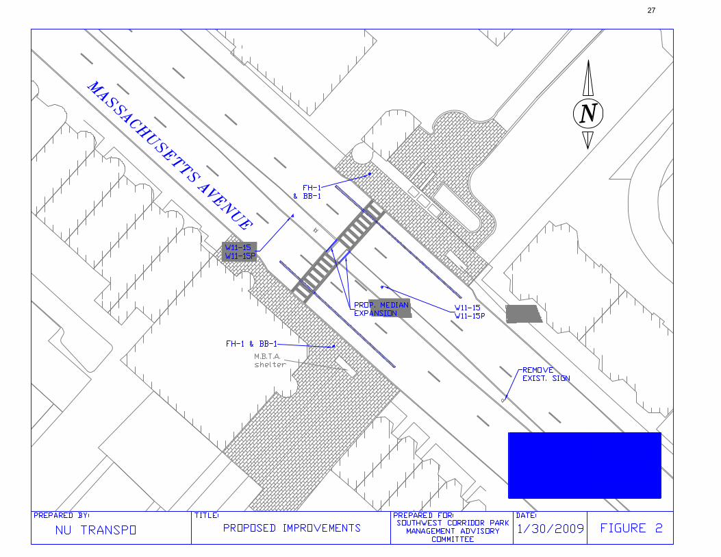
Issues: The intersection of the Southwest Corridor bicycle path and Massachusetts Avenue is a congested crossing carrying commuters to the MBTA, pedestrians, and cyclists. Mass. Ave is a four-lane collector road with high volumes of vehicle traffic. The main issue at this intersection is a lack of sight distance and effective advanced visual warning for motorists. The median on Mass Ave. eases crossing, but the curb cut in the median is not wide enough for both bikes and pedestri-ans to use. Most cyclists, including some on our own team, must hop the median during peak use.
S o u t h w e s t C o r r i d o r C r o s s i n g M a s s . Av e . Findings: There are some issues that can be resolved with low-cost solutions, the most critical find-ings are listed below. The following findings are based on actual field measurement and observations made by group members.
• Intersection Geometry • The crossing at Mass. Ave. has a 10
foot crosswalk and 10 foot wheelchair ramps. The median provides a crossing refuge for cyclists and pedestrians but is effectively a “bottleneck” for the crosswalk at only 6 feet. A larger curb cut through the median would deter cyclists from going outside the crossing and hopping the curb.
• The intersection lacks continuity for the cycle path and through use. However, it was determined that the turns a bicycle needs to make to use the crosswalk, as well as the high pedestrian volume, will make bikes naturally slow down and yield to pedestrians and oncoming traffic.
• Ineffective Signage for Vehicles • There are currently three signs on
Mass. Ave. to warn motorists of the crossing. However, they are attached to existing lampposts instead of be-ing in an advanced position to warn cars. The one sign that is in an ad-vanced position is too far away and about 10 feet off the ground much too high for a car to see. (see picture)
Recommendations (Figure 2): A number of recommendations have been identified and are presented in order of priority.
• Signage • The uniform mixed use path sign will
be added at appropriate spots in the median to ensure advanced warning.
• A sign will be added at the path merge before the intersection heading inbound to warn cyclists and pedestrians of the mixed use path.
• The advanced warning sign for vehi-cles on the southern leg of the inter-section should be removed.
• Intersection Geometry • The curb cut in the median is
proposed to be widened from 6 feet to 10 feet. This will remedy the bottle neck situation for cyclists as described earlier.
• Pavement Markings • Traveling inbound on the Southwest
Corridor, the path merges before Massachusetts Avenue into a com-bined use path. Thus, negating the need for pavement markings before and after the intersection. The typi-cal shark’s teeth markings and yield sign for a mid block crossing for cyclists will not be utilized at this intersection either. The pavement surface is brick, and cyclists are forced to yield to high levels of pe-destrians anyways.
Southwest Corridor Study Area
Mixed Use
Mass. Ave.
MBTA
St. B
otolp
h
Pedestrian Bottleneck in Median Pedestrian Warning Sign
26
27
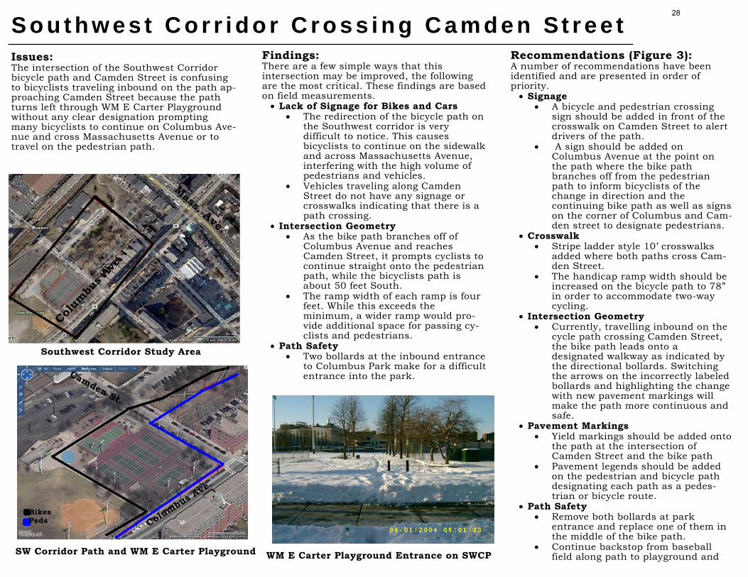
Issues: The intersection of the Southwest Corridor bicycle path and Camden Street is confusing to bicyclists traveling inbound on the path ap-proaching Camden Street because the path turns left through WM E Carter Playground without any clear designation prompting many bicyclists to continue on Columbus Ave-nue and cross Massachusetts Avenue or to travel on the pedestrian path.
S o u t h w e s t C o r r i d o r C r o s s i n g C a m d e n St r e e t Findings: There are a few simple ways that this intersection may be improved, the following are the most critical. These findings are based on field measurements.
• Lack of Signage for Bikes and Cars • The redirection of the bicycle path on
the Southwest corridor is very difficult to notice. This causes bicyclists to continue on the sidewalk and across Massachusetts Avenue, interfering with the high volume of pedestrians and vehicles.
• Vehicles traveling along Camden Street do not have any signage or crosswalks indicating that there is a path crossing.
• Intersection Geometry • As the bike path branches off of
Columbus Avenue and reaches Camden Street, it prompts cyclists to continue straight onto the pedestrian path, while the bicyclists path is about 50 feet South.
• The ramp width of each ramp is four feet. While this exceeds the minimum, a wider ramp would pro-vide additional space for passing cy-clists and pedestrians.
• Path Safety • Two bollards at the inbound entrance
to Columbus Park make for a difficult entrance into the park.
Recommendations (Figure 3): A number of recommendations have been identified and are presented in order of priority.
• Signage • A bicycle and pedestrian crossing
sign should be added in front of the crosswalk on Camden Street to alert drivers of the path.
• A sign should be added on Columbus Avenue at the point on the path where the bike path branches off from the pedestrian path to inform bicyclists of the change in direction and the continuing bike path as well as signs on the corner of Columbus and Cam-den street to designate pedestrians.
• Crosswalk • Stripe ladder style 10’ crosswalks
added where both paths cross Cam-den Street.
• The handicap ramp width should be increased on the bicycle path to 78” in order to accommodate two-way cycling.
• Intersection Geometry • Currently, travelling inbound on the
cycle path crossing Camden Street, the bike path leads onto a designated walkway as indicated by the directional bollards. Switching the arrows on the incorrectly labeled bollards and highlighting the change with new pavement markings will make the path more continuous and safe.
• Pavement Markings • Yield markings should be added onto
the path at the intersection of Camden Street and the bike path
• Pavement legends should be added on the pedestrian and bicycle path designating each path as a pedes-trian or bicycle route.
• Path Safety • Remove both bollards at park
entrance and replace one of them in the middle of the bike path.
• Continue backstop from baseball field along path to playground and SW Corridor Path and WM E Carter Playground
Southwest Corridor Study Area
WM E Carter Playground Entrance on SWCP
Mass. Ave.
Colum
bus A
ve.
Bikes Peds
Camden St.
Columbus Ave.
28

29

Issues: At the crossing of the Southwest Corridor along Melnea Cass Boulevard there are several areas that make riding or walking along the path confusing to cyclists and pedestrians. Bollards are poorly located and incorrectly label the paths. Moreover, the sidewalk ramps are far too small and the crosswalk is in need of maintenance.
S o u t h w e s t C o r r i d o r C r o s s i n g M e l n e a C a s s B l v d . Findings: After conducting a series field visits to evaluate the crossing, the following issues were identified.
• Signage - The sign on the bollard facing riders
heading inbound indicating which path is designated for cyclists and which is for pedestrians is very poorly located, making it very difficult for users to see it as they approach.
- The sign on the same bollard prompts cyclists to take the path on the right and the pedestrians to take the one on the left. However, after the crosswalk, both the cyclists and pedestrians are prompted to switch paths.
• Intersection Geometry - The sidewalk ramps are only 48” wide. - The crosswalk and sidewalk ramps do
not line up with the paths, creating sharp and awkward turns for cyclists.
• Pavement/Path Marking - There are no pavement markings on
the paths indicating which path is for cyclists and which is for pedestrians.
- The crosswalk is a standard parallel line crosswalk, as opposed to the more standard ladder crosswalk.
Recommendations (Figure 4): The following recommendations have been identified:
• Signage - Remove the path designation sign on
the bollard facing users heading inbound and replace it with the proposed “Path Merge” (SP-1) sign.
- Place a sign on the backside of the same bollard (facing users heading outbound) that designates the bike and pedestrian paths.
- On the bollard on the North leg of the intersection, place a “Path Merge” (SP-1) sign on the backside; the side facing users heading outbound.
- Use standard treatment for navigation signs at this intersection.
• Intersection Geometry - Increase both sidewalk ramps to the
standard 78”. - Realign the crosswalk so it lines up
with the 2 paths. • Pavement/Path Markings
- Add lines to the existing standard parallel line crosswalk to make it a more visible ladder crosswalk.
- Add the proposed bike and pedestrian markings to the bike and pedestrian paths, respectively, on the North leg of the intersection.
Southwest Corridor Looking Inbound- Bollard to be Modified
Southwest Corridor Heading Inbound– Poor Visibility
Southwest Corridor at Melnea Cass Blvd. Southwest Corridor Looking Inbound- Approx. 30 Feet from Previous Bollard
Intersection at
Melnea Cass
Tremont St.
Melnea Cass Blvd.
30

31

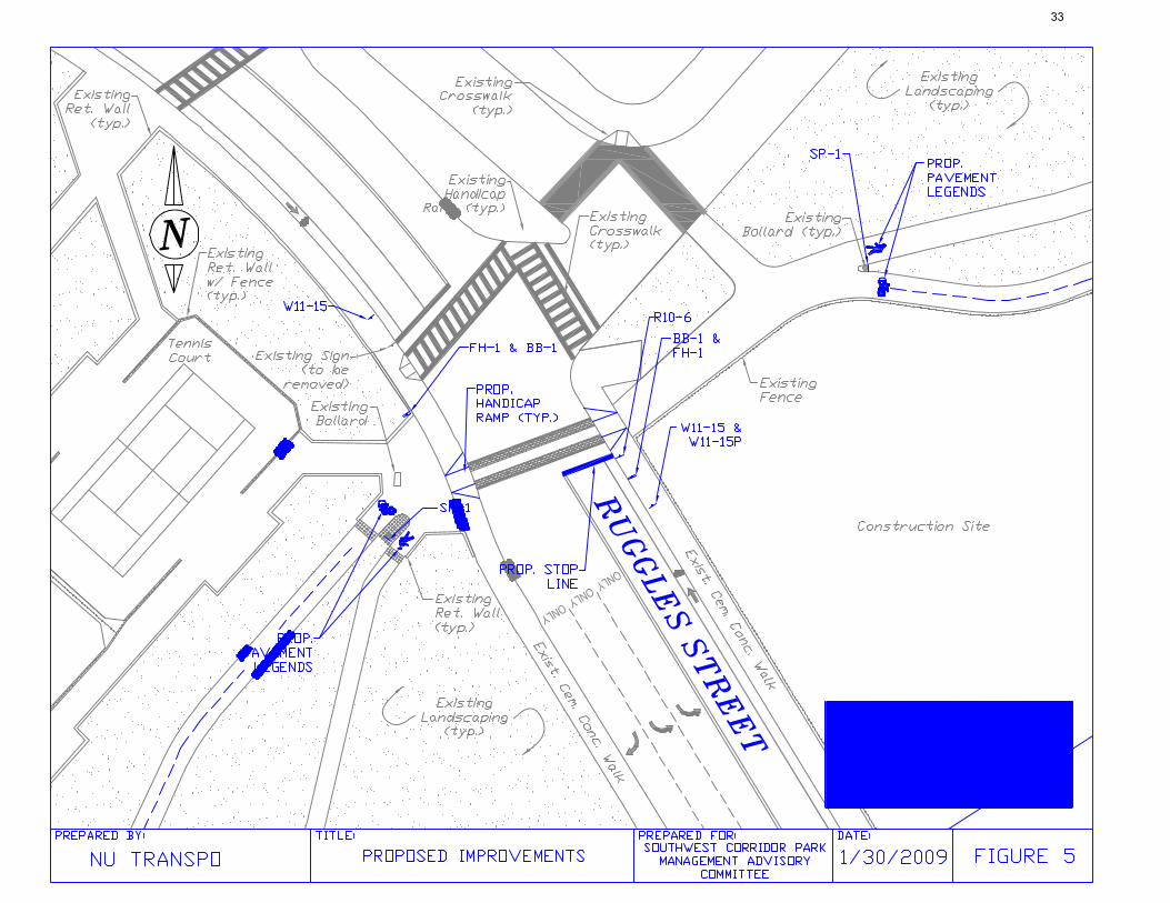
Issues: The intersection at Ruggles Street presents issues common to most of the crosswalk. The safety of the intersection is better than many others, as the SWCP has a stop light controlled by push button for two crosswalks. The crosswalk at the intersection was recently restriped and fitted with stone inlays, but could still be further improved to coordinate with the widening of the wheelchair ramps. The crosswalks also have some visibility issues as the crossing is on the top of a hill.
S o u t h w e s t C o r r i d o r C r o s s i n g R u g g l e s St r e e t Findings: There are some issues that can be resolved with low-cost solutions, the most critical find-ings are listed below. The following findings are based on actual field measurement and observations made by group members.
• Intersection Geometry • The crossing at Ruggles Street has
some sightline issues. The amount of traffic that now uses Ruggles Street warrants some visibility improve-ments for motorists. The crossing on Ruggles Street lies on a horizontal and vertical curve at the same time as shown in the picture below. The actual crosswalk itself is not visible to oncoming traffic.
• Ineffective Signage for Vehicles • There are not any signs to warn cars
of a pedestrian and cycle crossing ahead.
• Lack of Pavement Markings • There is no stop line on the South-
side leg of the crossing. • Lack of Pedestrian Clearance Time
• Ruggles Street is 50 feet wide and there is only 10 seconds of pedestrian clearance time.
Recommendations (Figure 5): A number of recommendations have been identified and are presented in order of priority.
• Pedestrian Clearance Time • The Flashing Don’t Walk (FDW)
phase needs to be increased to at least 15 seconds for a 50 foot intersection (assuming a 3.5 mph walking speed).
• Signage • The uniform mixed use path sign will
be added 30 feet from either side of the intersection.
• Our standard treatment of adding a path merge sign to the back of existing directional bollards.
• The uniform destination sign will be added at each entrance to the path.
• A “Stop Here on Red” sign will be added at the proposed stop line.
• Pavement Markings • The uniform treatment of adding a
cyclist and pedestrian legends at the path split will be applied on either side of the crossing at Ruggles Street.
• A stop line is proposed on the South-side leg of the intersection. To be set back six feet from edge of crosswalk.
• Ladder stripes are proposed for the inner section of the crosswalk.
• Wheelchair Ramps • The standard wheelchair ramp
widening will be applied here as the ramps are currently only 48 inches, However this cannot be completed on one side until construction fenc-ing is removed.
Southwest Corridor Study Area
Cyclist in New Crosswalk North-Side Leg Looking South
Mixed Use Path
Ruggles St.
Tremont S
t.
32
33

Issues: At the midblock crossing of the Southwest Corridor along Prentiss Street there is much confusion for drivers, bicyclists and pedestri-ans due to the lack of the right-of-way. The midblock crossing is particularly dangerous due to the lack of signage and pavement markings and poor sight lines.
S o u t h w e s t C o r r i d o r C r o s s i n g P r e n t i s s St r e e t Observations: NU Transpo conducted field visits to evaluate the crossing and identified the following is-sues.
• Signage - No signage on any approach clarifying
right of way. - No signage warning of crossing.
• Pavement/Path Markings - Only existing marking is the crosswalk
which is completely faded away. • Geometry
- Poor sightlines on Southern and East-ern approaches due to railway panel-ing on bridge over tracks.
• Other Observations - Cobble inlay at path intersection
meant to warn bicyclists of intersec-tion is ineffective and uncomfortable for bicyclists.
Recommendations (Figure 6): The following recommendations have been identified:
• Signage - Add bicycle/pedestrian path crossing
sign on vehicle approaches on Prentiss Street.
- Add signage on path warning of path merge.
- Add yield sign for bicyclists. - Promotional signage along vehicle ap-
proach alerting bicyclists of path and distances to destinations.
• Crosswalk - Repaint ladder style crosswalk 10’
wide. • Pavement/Path Markings
- Mark bike path with bicycle legend denoting it is for bicycles.
- Mark pedestrian path with pedestrian legend denoting it is for pedestrians.
- Add double yellow striping along cen-terline of Prentiss Street.
- Add dashed centerline along bike path to keep bicyclists from riding on cen-ter of path.
• Geometry - Install yield signs for bicyclists to ad-
dress sight line deficiencies on Pren-tiss Street SB approach due to railway paneling on bridge.
• Cobble - Remove cobble inlay on path approach
and replace with asphalt to make for a smoother transition for bicycles and wheelchairs.
Southwest Corridor Outbound
Blocked Sightline Due to Paneling
Southwest Corridor at Prentiss St
34

35

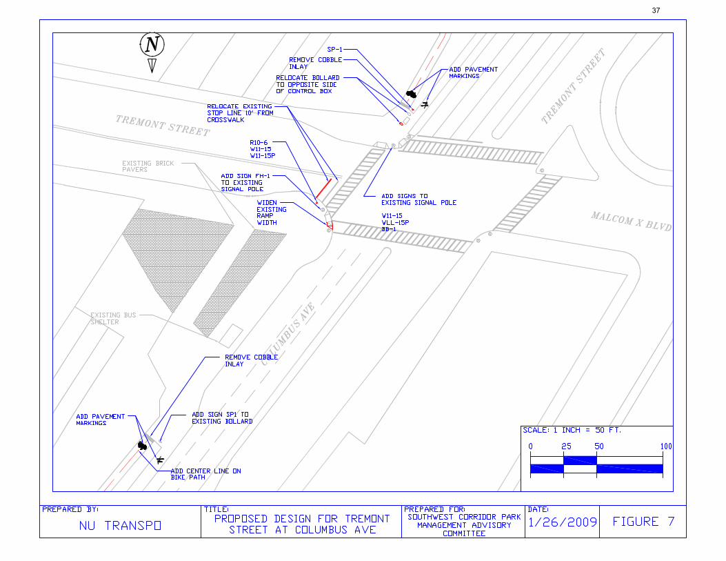
Issues: At the crossing of the Southwest Corridor and Tremont Street at Roxbury Crossing there is a lack of driver awareness of the crossing pedes-trians and cyclists. The crossing is relatively safe due to it being signalized with an exclu-sive pedestrian phase however some small changes can be made to enhance the safety of this intersection
R o x b u r y C r o s s i n g Observations: NU Transpo conducted field visits to evaluate the crossing and identified the following is-sues.
• Signage - Inbound directional bollard blocked by
signal control box. - Lack of signage indicating bicycle path
crossing. • Pavement/Path Markings
- Stop bar is too close to the crosswalk resulting in vehicles blocking bicycles.
- Crosswalk is in good condition and of acceptable width.
• Traffic and Pedestrian Signals - Long cycle lengths are caused by ex-
clusive pedestrian phasing and results in high pedestrian/cyclist noncompli-ance.
• Geometry - Southwest leg crosswalks merge to one
narrow pedestrian ramp, creating a bottleneck.
• Other Observations - Cobble inlay meant to warn bicyclists
of intersection is ineffective and un-comfortable for bicyclists.
Recommendations (Figure 7): The following recommendations have been identified:
• Signage - Add signs at all approaches to warn of
crossing. - Move bollard in front of control box. - Add signage on path warning of path
merge. - Add ‘Stop Here On Red’ sign and align
with stop line. - Add promotional signage along vehicle
approach for bicycles. • Pavement/Path Markings
- Set stop line 10’ back from crosswalk. - Mark bike path with bicycle marking
denoting it is for bicycles. - Mark pedestrian path with pedestrian
marking denoting it is for pedestrians. - Add dashed centerline along bike
path. • Traffic and Pedestrian Signals
- Conduct traffic studies to asses feasi-bility of shortening the cycle length by allowing for concurrent pedestrian phasing with recall.
• Geometry - Widen existing ramp on Southwest leg
for merging crosswalk to meet 78” minimum width.
• Cobble - Remove cobble inlay and replace with
asphalt to make for a smoother transi-tion for bicycles and wheelchairs.
Southwest Corridor Outbound — Note vehicle in upper left that is stopped in the crosswalk
Inbound—Blocked Directional Bollard at Tremont Street Southwest Corridor at Tremont St
36
37

Issues: At the signalized crossing of the Southwest Corridor and New Cedar Street poor mainte-nance has led to faded signs and crosswalks, resulting in low vehicular awareness of the bicycle intersection. The intersection is rela-tively safe due to the low traffic volumes and signal but small improvements can be made to enhance the safety of this intersection as well as making it more comfortable for users.
C o l u m b u s Av e n u e a t N e w C e d a r St r e e t Observations: NU Transpo conducted field visits to evaluate the crossing and identified the following is-sues.
• Signage - Bollard blocked by signal control box. - Faded signs that are too high for driv-
ers to see. - ‘Stop Here On Red’ sign points to
crosswalk instead of stop line. • Pavement/Path Markings
- Stop bar is too close to the crosswalk resulting in vehicles blocking bicycles.
- Existing markings are faded. • Geometry
- Ramps are too narrow and only one exists for outbound leg on the north side of Columbus and inbound and outbound for the south side of Colum-bus.
- Large radius turn on westbound ap-proach vehicles turning northbound promotes fast driving.
• Other Observations - Cobble inlay meant to warn bicyclists
of intersection is ineffective and un-comfortable for bicyclists.
- Cars often stop in crosswalk waiting to turn right on red.
Recommendations (Figure 8): The following recommendations have been identified:
• Signage - Move bollard in front of control box. - Replace bicycle/pedestrian path
crossing sign at vehicle approaches and put at appropriate height.
- Replace faded signs. - Re-align ‘Stop Here On Red’ sign with
stop line. - Add signage on path warning of path
merge. - Promotional signage along vehicle ap-
proach alerting bicyclists of path and distances to destinations.
- Add NTOR sign on New Cedar Street so drivers will not stop in crosswalk.
• Crosswalk - Repaint ladder style crosswalk 10’
wide. - Move crosswalk on Columbus back to
allow for new ramp. • Pavement/Path Markings
- Set stop line 10’ back from cross-walks.
- Mark bike path with bicycle legend denoting it is for bicycles.
- Mark pedestrian path with pedestrian legend denoting it is for pedestrians.
- Add dashed centerline along bike path.
• Geometry - Reduce the radius of the curbs and
add a ramp for each crosswalk that is 78” wide.
• Cobble - Remove cobble inlay and replace with
asphalt to make for a smoother transi-tion for bicycles and wheelchairs.
Southwest Corridor Outbound
Outbound— Blocked Directional Bollard at New Cedar Street
Southwest Corridor at New Cedar Street
38

39
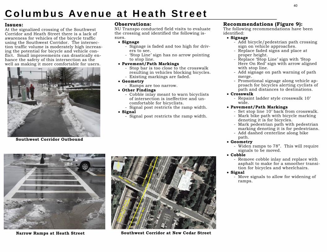
Issues: At the signalized crossing of the Southwest Corridor and Heath Street there is a lack of awareness for vehicles of the bicycle traffic using the Southwest Corridor. The intersec-tion traffic volume is moderately high increas-ing the potential for bicycle and vehicle con-flict. Small improvements can drastically en-hance the safety of this intersection as the well as making it more comfortable for users.
C o l u m b u s Av e n u e a t H e a t h St r e e t Observations: NU Transpo conducted field visits to evaluate the crossing and identified the following is-sues.
• Signage - Signage is faded and too high for driv-
ers to see. - ‘Stop Line’ sign has no arrow pointing
to stop line. • Pavement/Path Markings
- Stop bar is too close to the crosswalk resulting in vehicles blocking bicycles.
- Existing markings are faded. • Geometry
- Ramps are too narrow. • Other Findings
- Cobble inlay meant to warn bicyclists of intersection is ineffective and un-comfortable for bicyclists.
- Signal post restricts the ramp width. • Signal
- Signal post restricts the ramp width.
Recommendations (Figure 9): The following recommendations have been identified:
• Signage - Add bicycle/pedestrian path crossing
sign on vehicle approaches. - Replace faded signs and place at
proper height. - Replace ‘Stop Line’ sign with ‘Stop
Here On Red’ sign with arrow aligned with stop line.
- Add signage on path warning of path merge.
- Promotional signage along vehicle ap-proach for bicycles alerting cyclists of path and distances to destinations.
• Crosswalk - Repaint ladder style crosswalk 10’
wide. • Pavement/Path Markings
- Set stop line 10’ back from crosswalk. - Mark bike path with bicycle marking
denoting it is for bicycles. - Mark pedestrian path with pedestrian
marking denoting it is for pedestrians. - Add dashed centerline along bike
path. • Geometry
- Widen ramps to 78”. This will require signals to be moved.
• Cobble - Remove cobble inlay and replace with
asphalt to make for a smoother transi-tion for bicycles and wheelchairs.
• Signal - Move signals to allow for widening of
ramps.
Southwest Corridor Outbound
Narrow Ramps at Heath Street Southwest Corridor at New Cedar Street
40

41

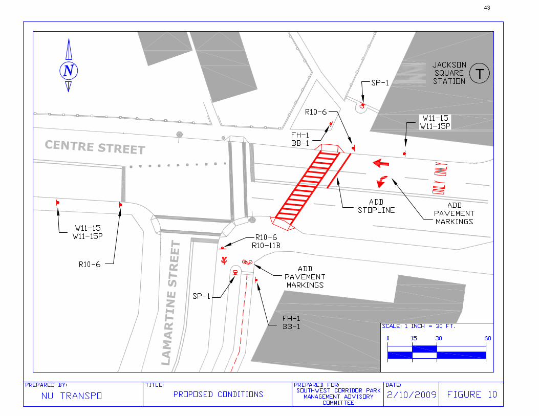
Southwest Corridor Crossing Centre Street (Jackson Square) Issues: The intersection of Centre Street with the Southwest Corridor Path (SWCP) poses a major concern regarding crossing alignment, specifically for bicyclists. Current conditions force path users to cross Centre St. offset from their previous heading while sharing a narrow sidewalk with other conflicting users. Other matters include signage consistent throughout the SWCP and minor maintenance matters. Centre St. & Lamartine St.
Centre Street Study Area
Findings: NU Transpo conducted a field inventory to assess possible solutions and improve the safety of the intersection. Two subjects identified as needing improvement: • Crossing Alignment
- Bicyclists crossing Centre St. face a conflict with pedestrians on the north side leg due to tight a right angle turn onto and off of an already narrow sidewalk.
- SWCP approaches on either side of Centre St. are offset and angled differently, eliminating a smooth transition for path users.
- No signage exists to distinguish the right of way for all intersection users.
- Handicap ramps not adequate width for shared use of bicyclists and pedestrians.
Bicyclist Crossing Centre St. From Lamartine St. w/ Conflicting Pedestrians
• Maintenance Issues - The Drainage grate on the north side leg is oriented in wrong direction. - Missing mast arm pedestal plate on traffic signal (shown above on South East corner). - Granite pavers at path entries/exits in poor condition on both sides of Centre St.
Recommendation (Figure 10): The following recommendations are proposed:
• Crosswalk Realignment − Crosswalk will be rotated to align better with
the path at the northern side of the intersection.
− Stopline, lane pavement markings, and loop detectors will be moved back on the westbound approach approximately 50 ft. (consistent with the new crosswalk). New signal sight distance adheres to MUTCD requirements.
− Curb cuts will be readjusted for the new crossing, with 6.5 ft wide HC ramps.
− All pushbuttons will be deactivated and concurrent pedestrian phasing with a 4 second lead interval will be set. This will allow pedestrians and bicyclists to establish their crossing priority and minimize conflict with vehicular traffic.
− Eliminate the old crosswalk and pavement markings.
− Reconstruct sidewalk at old curb cuts.
• Signage / Pavement Markings − Trail crossing signs should be placed before
the crossing on both approaches of Centre Street.
− Stop Here on Red signs will be placed at each stopline.
− Path Merge signs installed on the back of the guidance bollards located at the entrances on the path.
− Destination signs will be placed on both sides of Centre St. to direct path users and provide a time frame for their trips.
− Bicycle and pedestrian symbols will be installed at the path entrances for further guidance to users.
− A centerline on the bike path will be installed to further delineate its separation from the pedestrian path.
− Address maintenance issues as necessary.
Centre Street
Columbus Ave
Lamartine Street
42
43
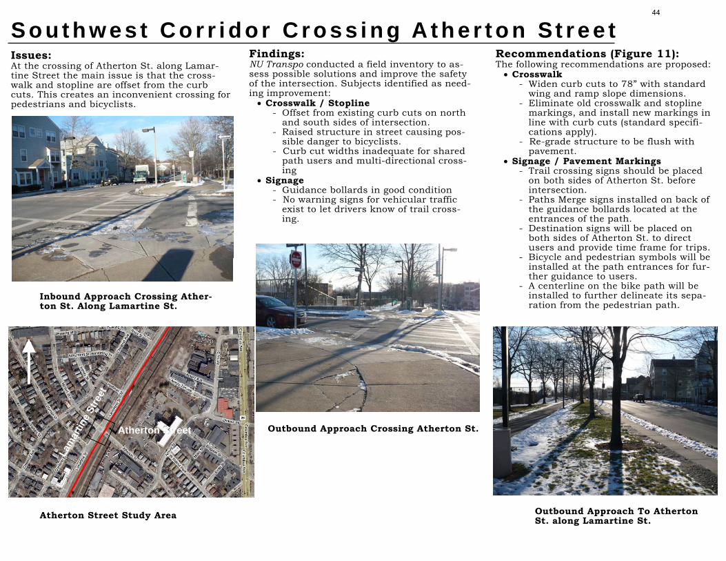
Issues: At the crossing of Atherton St. along Lamar-tine Street the main issue is that the cross-walk and stopline are offset from the curb cuts. This creates an inconvenient crossing for pedestrians and bicyclists.
S o u t h w e s t C o r r i d o r C r o s s i n g A t h e r t o n St r e e t Findings: NU Transpo conducted a field inventory to as-sess possible solutions and improve the safety of the intersection. Subjects identified as need-ing improvement:
• Crosswalk / Stopline - Offset from existing curb cuts on north
and south sides of intersection. - Raised structure in street causing pos-
sible danger to bicyclists. - Curb cut widths inadequate for shared
path users and multi-directional cross-ing
• Signage - Guidance bollards in good condition - No warning signs for vehicular traffic
exist to let drivers know of trail cross-ing.
Recommendations (Figure 11): The following recommendations are proposed:
• Crosswalk - Widen curb cuts to 78” with standard
wing and ramp slope dimensions. - Eliminate old crosswalk and stopline
markings, and install new markings in line with curb cuts (standard specifi-cations apply).
- Re-grade structure to be flush with pavement.
• Signage / Pavement Markings - Trail crossing signs should be placed
on both sides of Atherton St. before intersection.
- Paths Merge signs installed on back of the guidance bollards located at the entrances of the path.
- Destination signs will be placed on both sides of Atherton St. to direct users and provide time frame for trips.
- Bicycle and pedestrian symbols will be installed at the path entrances for fur-ther guidance to users.
- A centerline on the bike path will be installed to further delineate its sepa-ration from the pedestrian path.
Inbound Approach Crossing Ather-ton St. Along Lamartine St.
Atherton Street Study Area
Outbound Approach Crossing Atherton St.
Lam
artin
e St
reet
Atherton Street
Outbound Approach To Atherton St. along Lamartine St.
44

45

Issues: At the crossing of Boylston St. and Lamartine St., the main issue of concern is the lack of pedestrian compliance due to ped phases be-ing actuated and not concurrent.
S o u t h w e s t C o r r i d o r C r o s s i n g B o y l s t o n St r e e t Findings: NU Transpo conducted a field inventory to assess possible solutions and improve the safety of the intersection. Subjects identified as needing improvement:
• Signal Phasing - Pedestrian phasing is exclusive and
actuated. This causes poor compliance from both pedestrians and bicyclists due to the excessive delay.
- Pushbutton is in especially inconven-ient location for bicyclists on the north side leg of the intersection, further de-creasing compliance.
• Crosswalk - Curb cuts are of inadequate width. - Sidewalks provide ample queuing area
for both pedestrians and bicyclists. - Crosswalk in decent condition but of
insufficient width.
From Boylston St. Looking West Across Intersection
Boylston Street Study Area
Outbound Approach Crossing Boylston Street
Boylston Street
Lam
artin
e St
reet
T
Recommendations (Figure 12): The following recommendations are proposed:
• Signal Phasing - Due to high pedestrian volumes from
the T station, change pedestrian phas-ing from actuated and exclusive to automatic and concurrent.
- Remove pushbuttons from signal ped-estals to avoid confusion.
• Signage / Pavement Markings - Trail crossing signs should be placed
on both sides of Boylston St. before intersection.
- Install new guidance bollard with path merging sign at path entrance on the north side leg of the intersection.
- Paths Merge signs installed on back of the guidance bollards located at the entrances of the path.
- Destination signs will be placed on both sides of Boylston St. to direct users and provide time frame for trips.
- Bicycle and pedestrian symbols will be installed at the path entrances for fur-ther guidance to users.
- A centerline on the bike path will be installed to further delineate its sepa-ration from the pedestrian path.
• Crosswalk - Widen curb cuts and repaint cross-
walk to standard.
Inbound Approach Crossing Boylston Street
46

47

Issues: At the midblock crossing of the Southwest Corridor and New Minton Street, the main concern is the right of way designation for crossers. Current conditions provide no right of way guidance and little warning for all ap-proaches. Other matters include adding sign-age consistent throughout the SWCP and ad-dressing minor maintenance issues.
S o u t h w e s t C o r r i d o r C r o s s i n g N e w M i n t o n St r e e t Findings: NU Transpo conducted field visits to evaluate the crossing and identified the following is-sues.
• Signage - Little signage for any approach warn-
ing of crossing conflict. • Pavement/Path Markings
- Only existing marking is the cross-walk.
• Geometry - Existing curb cuts are too narrow to
accommodate passing bicyclists. • Other Findings
- Cobble inlay meant to warn bicyclists of intersection is ineffective and un-comfortable for bicyclists.
Outbound Approach Crossing New Minton Street
New Minton Street Study Area
Inbound Approach Crossing New Minton
Lam
artin
e St
reet
New
Recommendations (Figure 13): The following recommendations are proposed:
• Crosswalk - Widen curb cuts to 78” with standard
wing and ramp slope dimensions. - Eliminate old crosswalk markings,
and install new markings in line with curb cuts (standard specifications ap-ply).
• Signage / Pavement Markings - Trail crossing signs should be placed
on both sides of New Minton St. before intersection.
- Paths Merge signs installed on back of the guidance bollards located at the entrances of the path.
- Destination signs will be placed on both sides of New Minton St. to direct path users and provide time frame for trips.
- Bicycle and pedestrian symbols will be installed at the path entrances for fur-ther guidance to users.
- A centerline on the bike path will be installed to further delineate its sepa-ration from the pedestrian path.
- Add sharks teeth to the path to warn users of crossing and instruct them to yield to vehicular traffic.
Outbound Approach SWCP
48

49

Southwest Corridor Crossing Green Street Station Issues: The SWCP goes in front of the Green Street MBTA Station. To the north of the station the path crosses at the intersection of Green St. and Amory St. This is a 4-way signalized intersection with concurrent walk. To the south of the station the path crosses at the intersection of Gordon St. and Amory St. This is a one way stop controlled on Gordon St. The poor maintenance and lack of signage for motorist make these intersections have a high potential for crashes and conflicts.
Findings: NU Transpo has conducted a field visit and observed the area in order to identify the existing problems and conditions. Some of the issues that were recognized are the following: • Roadway Signage
- There is not signage on the Green St, Gordon St., and Amory St. approaches warning vehicle there is a path crossing.
• Path Signage − The bollard on the north side leg of the
path is blocked by a traffic controller box. This may create confusion for the path users as to which path they should be using. (see below)
• Pavement Markings - Due to the lack of maintenance the stop
line for vehicles heading East on Green Street has been worn away. (see below)
• Curb Cuts - The crosswalk across Gordon St. does
not line up with the existing handicap ramps. There is also a catch basin in the middle of the crosswalk on both sides of Gordon St.
Recommendations (Figure 14): A number of recommendations have been identified and are depicted in Figure 14. Below is a detailed description of each recommended item, in order of priority. • Roadway Signage
- Signage should be added at all approaches indicating there is a path crossing ahead.
• Path Signage - The bollard on the north side leg should
be moved next to the traffic controller. - A new guide sign should be installed.
• Pavement Markings - A Stop line should be added on the west
side leg of Green Street. - A middle divider should be added on the
bike path. - A bike legend should be added at the
beginning of the divided path on both sides of the T station.
• Curb Cuts - The curb cuts on the Gordon St
crosswalk should be relocated to the center of the crosswalk. Also the catch basins should be relocated as indicated on Figure 14.
Aerial View
Sign Blocked by Traffic Controller Missing Stop Line
50

51
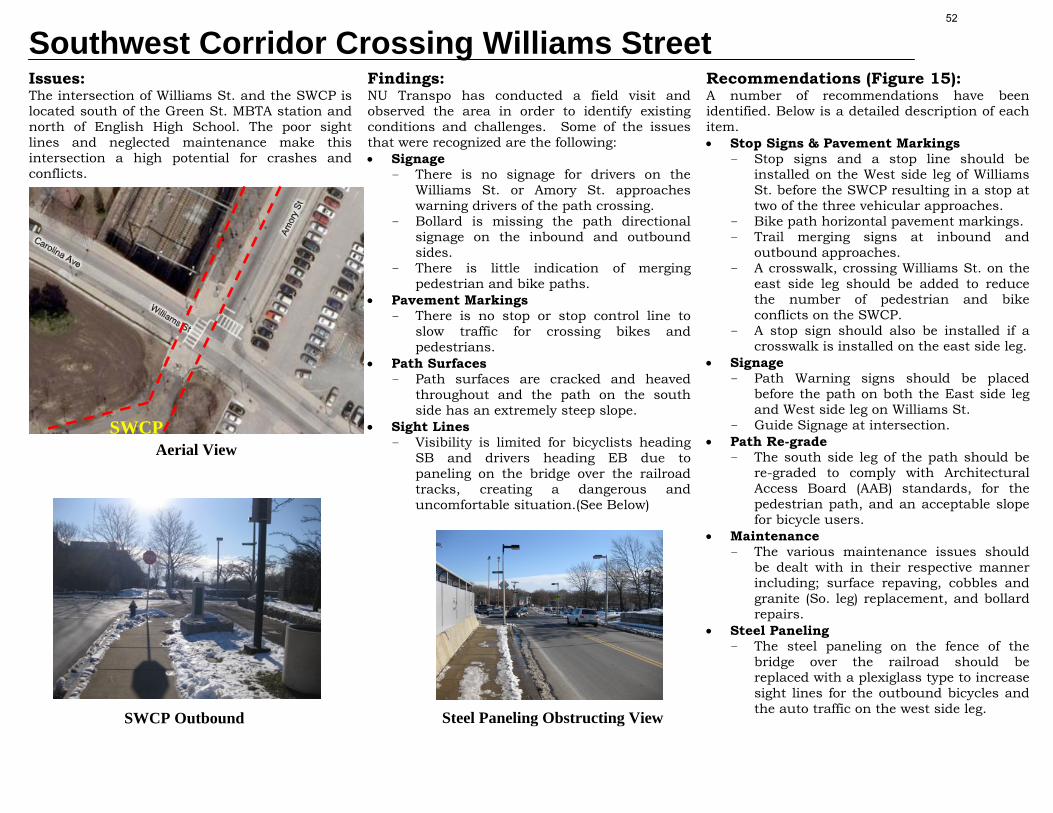
Southwest Corridor Crossing Williams Street Issues: The intersection of Williams St. and the SWCP is located south of the Green St. MBTA station and north of English High School. The poor sight lines and neglected maintenance make this intersection a high potential for crashes and conflicts.
Findings: NU Transpo has conducted a field visit and observed the area in order to identify existing conditions and challenges. Some of the issues that were recognized are the following: • Signage
- There is no signage for drivers on the Williams St. or Amory St. approaches warning drivers of the path crossing.
- Bollard is missing the path directional signage on the inbound and outbound sides.
- There is little indication of merging pedestrian and bike paths.
• Pavement Markings - There is no stop or stop control line to
slow traffic for crossing bikes and pedestrians.
• Path Surfaces - Path surfaces are cracked and heaved
throughout and the path on the south side has an extremely steep slope.
• Sight Lines - Visibility is limited for bicyclists heading
SB and drivers heading EB due to paneling on the bridge over the railroad tracks, creating a dangerous and uncomfortable situation.(See Below)
Recommendations (Figure 15): A number of recommendations have been identified. Below is a detailed description of each item. • Stop Signs & Pavement Markings
- Stop signs and a stop line should be installed on the West side leg of Williams St. before the SWCP resulting in a stop at two of the three vehicular approaches.
- Bike path horizontal pavement markings. - Trail merging signs at inbound and
outbound approaches. - A crosswalk, crossing Williams St. on the
east side leg should be added to reduce the number of pedestrian and bike conflicts on the SWCP.
- A stop sign should also be installed if a crosswalk is installed on the east side leg.
• Signage - Path Warning signs should be placed
before the path on both the East side leg and West side leg on Williams St.
- Guide Signage at intersection. • Path Re-grade
- The south side leg of the path should be re-graded to comply with Architectural Access Board (AAB) standards, for the pedestrian path, and an acceptable slope for bicycle users.
• Maintenance - The various maintenance issues should
be dealt with in their respective manner including; surface repaving, cobbles and granite (So. leg) replacement, and bollard repairs.
• Steel Paneling - The steel paneling on the fence of the
bridge over the railroad should be replaced with a plexiglass type to increase sight lines for the outbound bicycles and the auto traffic on the west side leg.
Aerial View SWCP
SWCP Outbound Steel Paneling Obstructing View
52

53

Southwest Corridor Crossing McBride StreetIssues: The intersection of McBride St. and Call St with the Southwest corridor is located half between Green MBTA station to the north and Forest Hills MBTA station to the south. It is a three way intersection with stop signs on all approaches. With students, commuters, and others crossing this intersection, the non-existence of some elements makes this intersection a high potential for crashes and conflicts.
Findings: Our group has conducted a field visit and observed the area in order to identify the existing problems and conditions. Some of the issues that were recognized are the following: • Signage
- There is no signage on the McBride St. or Call St. approaches warning vehicles of the path crossing.
• Pavement Markings - There is no corresponding stop line for
the all-stop on the East Side Leg of McBride St. to stop vehicle traffic for crossing bikes and pedestrians.
Recommendations (Figure 16): A number of recommendations have been identified and put into the matrix in Figure 16, showing respective cost and priority. Below is a detailed description of each item. • Pavement Markings
- A stop line should be installed on the East Side leg of McBride St. before the SWC Path.
• Roadway Signage - Signage should be added at all
approaches indicating there is a path crossing ahead.
• Path Signage - The destination signs should be
installed. - Path Merge Signs should be installed on
both the north side leg and south side leg.
• Path Pavement Markings - Typical path designation legends and
centerline should be added.
Aerial View
Lower Southwest Corridor Study Area
Minimal Path Crossing Signage
Missing Stop Line
54

55
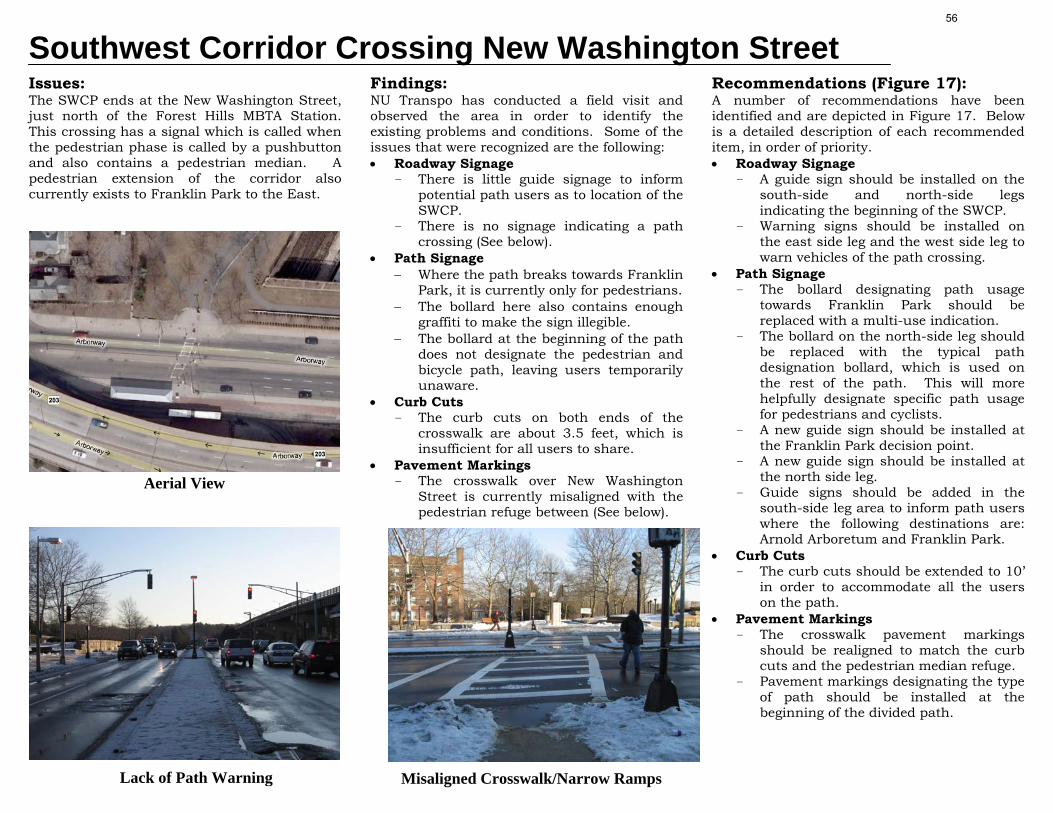
Southwest Corridor Crossing New Washington Street Issues: The SWCP ends at the New Washington Street, just north of the Forest Hills MBTA Station. This crossing has a signal which is called when the pedestrian phase is called by a pushbutton and also contains a pedestrian median. A pedestrian extension of the corridor also currently exists to Franklin Park to the East.
Findings: NU Transpo has conducted a field visit and observed the area in order to identify the existing problems and conditions. Some of the issues that were recognized are the following: • Roadway Signage
- There is little guide signage to inform potential path users as to location of the SWCP.
- There is no signage indicating a path crossing (See below).
• Path Signage − Where the path breaks towards Franklin
Park, it is currently only for pedestrians. − The bollard here also contains enough
graffiti to make the sign illegible. − The bollard at the beginning of the path
does not designate the pedestrian and bicycle path, leaving users temporarily unaware.
• Curb Cuts - The curb cuts on both ends of the
crosswalk are about 3.5 feet, which is insufficient for all users to share.
• Pavement Markings - The crosswalk over New Washington
Street is currently misaligned with the pedestrian refuge between (See below).
Recommendations (Figure 17): A number of recommendations have been identified and are depicted in Figure 17. Below is a detailed description of each recommended item, in order of priority. • Roadway Signage
- A guide sign should be installed on the south-side and north-side legs indicating the beginning of the SWCP.
- Warning signs should be installed on the east side leg and the west side leg to warn vehicles of the path crossing.
• Path Signage - The bollard designating path usage
towards Franklin Park should be replaced with a multi-use indication.
- The bollard on the north-side leg should be replaced with the typical path designation bollard, which is used on the rest of the path. This will more helpfully designate specific path usage for pedestrians and cyclists.
- A new guide sign should be installed at the Franklin Park decision point.
- A new guide sign should be installed at the north side leg.
- Guide signs should be added in the south-side leg area to inform path users where the following destinations are: Arnold Arboretum and Franklin Park.
• Curb Cuts - The curb cuts should be extended to 10’
in order to accommodate all the users on the path.
• Pavement Markings - The crosswalk pavement markings
should be realigned to match the curb cuts and the pedestrian median refuge.
- Pavement markings designating the type of path should be installed at the beginning of the divided path.
Aerial View
Lack of Path Warning Misaligned Crosswalk/Narrow Ramps
56

57

Southwest Corridor Crossing Washington Street Issues: The intersection of Washington Street and New Washington Street with the Southwest Corridor is located northeast of the Forest Hills station and east of the end of the bike path. Although it is used mostly by motorist on the busy Washington Street thoroughfare, in its current condition, it proves dangerous for crossings heading towards Franklin Park due to its complexity.
Findings: NU Transpo has conducted a field visit and observed the area in order to identify the existing problems and conditions. Some of the issues that were recognized are the following: • Path Designation
- The path from the MBTA Orange line tracks east is currently marked as a pedestrian only path.
• Signage - There is no signage at the intersection
indicating that there is a crossing or any directional signs leading path users to destination points.
• Pavement Markings - Pavement markings are worn in and
around the general area of the intersection.
- The crosswalks are arranged in such a way that requires multiple crossings to continue on the path.
• Intersection Configuration - On the north leg of the intersection
there is a right hand turning lane that has low traffic volumes.
Recommendations (Figure 18): A number of recommendations have been identified in Figure 18. Below is a detailed description of each item. • Change in Path Designation
- The path from the MBTA Orange Line headed east should be a multi-use path with the bollards changed to reflect a shared usage between pedestrians and bicyclists.
• Signage: - Path warning signage at vehicular
approaches. - Directional signage should be added
near the path bollards for users entering path from the north and south.
- Guide signage should be installed at intersection..
• Intersection Configuration: - The right hand turning lane should be
discontinued and the edge of the intersection extended. This will allow for increased visibility and ease pedestrian crossings along the path.
• Pavement Markings: - Reconfigure the crosswalk for travel
along the east-west direction that would coincide with the elimination of the right hand turning lane.
- Add an additional crosswalk in the north-south direction of the intersection on the west leg of the intersection. This will allow path users greater flexibility if they are heading to and from the Forest Hills T station.
Washington St at New Washington St
North Side Leg
SWCP
Pedestrian Only Path Designation
58

59