reassessment of the historical seismic activity with major ... · reassessment of the historical...
TRANSCRIPT
HAL Id: hal-00299080https://hal.archives-ouvertes.fr/hal-00299080
Submitted on 1 Jan 2003
HAL is a multi-disciplinary open accessarchive for the deposit and dissemination of sci-entific research documents, whether they are pub-lished or not. The documents may come fromteaching and research institutions in France orabroad, or from public or private research centers.
L’archive ouverte pluridisciplinaire HAL, estdestinée au dépôt et à la diffusion de documentsscientifiques de niveau recherche, publiés ou non,émanant des établissements d’enseignement et derecherche français ou étrangers, des laboratoirespublics ou privés.
Reassessment of the historical seismic activity withmajor impact on S. Miguel Island (Azores)
D. Silveira, J. L. Gaspar, T. Ferreira, G. Queiroz
To cite this version:D. Silveira, J. L. Gaspar, T. Ferreira, G. Queiroz. Reassessment of the historical seismic activity withmajor impact on S. Miguel Island (Azores). Natural Hazards and Earth System Science, CopernicusPublications on behalf of the European Geosciences Union, 2003, 3 (6), pp.615-623. <hal-00299080>
Natural Hazards and Earth System Sciences (2003) 3: 615–623© European Geosciences Union 2003 Natural Hazards
and EarthSystem Sciences
Reassessment of the historical seismic activity with major impact onS. Miguel Island (Azores)
D. Silveira, J. L. Gaspar, T. Ferreira, and G. Queiroz
Centro de Vulcanologia e Avaliacao de Riscos Geologicos, Universidade dos Acores, Rua Mae de Deus, 9501–801 PontaDelgada, Acores, Portugal
Received: 11 December 2002 – Accepted: 14 February 2003
Abstract. On account of its tectonic setting, both seismicand volcanic events are frequent in the Azores archipelago.During the historical period earthquakes and seismic swarmsof tectonic and/or volcanic origin have struck S. Miguel Is-land causing a significant number of casualties and severedamages. The information present in historical records madepossible a new macroseismic analysis of these major eventsusing the European Macroseismic Scale-1998 (EMS-98).
Among the strongest earthquakes of tectonic origin thataffected S. Miguel Island, six events were selected for thisstudy. The isoseismal maps drawn for these events enabledthe identification of areas characterized by anomalous valuesof seismic intensity, either positive or negative, to constrainepicentre locations and to identify some new seismogenic ar-eas.
Regarding seismic activity associated with volcanic phe-nomena six cases were also selected. For each of the studiedcases cumulative intensity values were assessed for each lo-cality. The distribution of local intensity values shows thatthe effects are not homogeneous within a certain distancefrom the eruptive centre, the area of major impacts relateswith the eruptive style and damages equivalent to high inten-sities may occur in Furnas and Sete Cidades calderas.
Combining all the historical macroseismic data, a maxi-mum intensity map was produced for S. Miguel Island.
1 Introduction
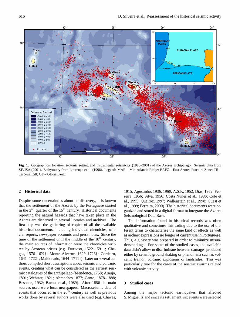
The Azores archipelago is located in the North AtlanticOcean where the American, African and Eurasian litho-spheric plates meet (e.g. Searle, 1980) (Fig. 1). The so-calledAzores Triple Junction is dominated by three main tectonicfeatures: the Mid-Atlantic Ridge (MAR), which crosses thearchipelago between the islands of Faial and Flores with ageneral N–S direction (Krause and Watkins, 1970; Steinmetz
Correspondence to:D. Silveira([email protected])
et al., 1976); the East Azores Fracture Zone, which extendsE–W from the MAR to the Strait of Gibraltar (Krause, 1965),including the Gloria Fault (Laughton and Whitmarsh, 1974);and the Terceira Rift, which trends NW–SE along a line de-fined by Graciosa, Terceira and S. Miguel islands (Machado,1959), that comprises, in a wide sense, the WNW–ESE frac-ture systems of Faial, Pico and S. Jorge islands. Whilethe boundary between the American and the Eurasian andAfrican plates is well established by the MAR, the locationand nature of the eastern branch of the Azores Triple Junc-tion is still controversial (e.g. Madeira and Ribeiro, 1990;Luıs, 1996; Lourenco et al., 1998; Madeira, 1998; Mirandaet al., 1998).
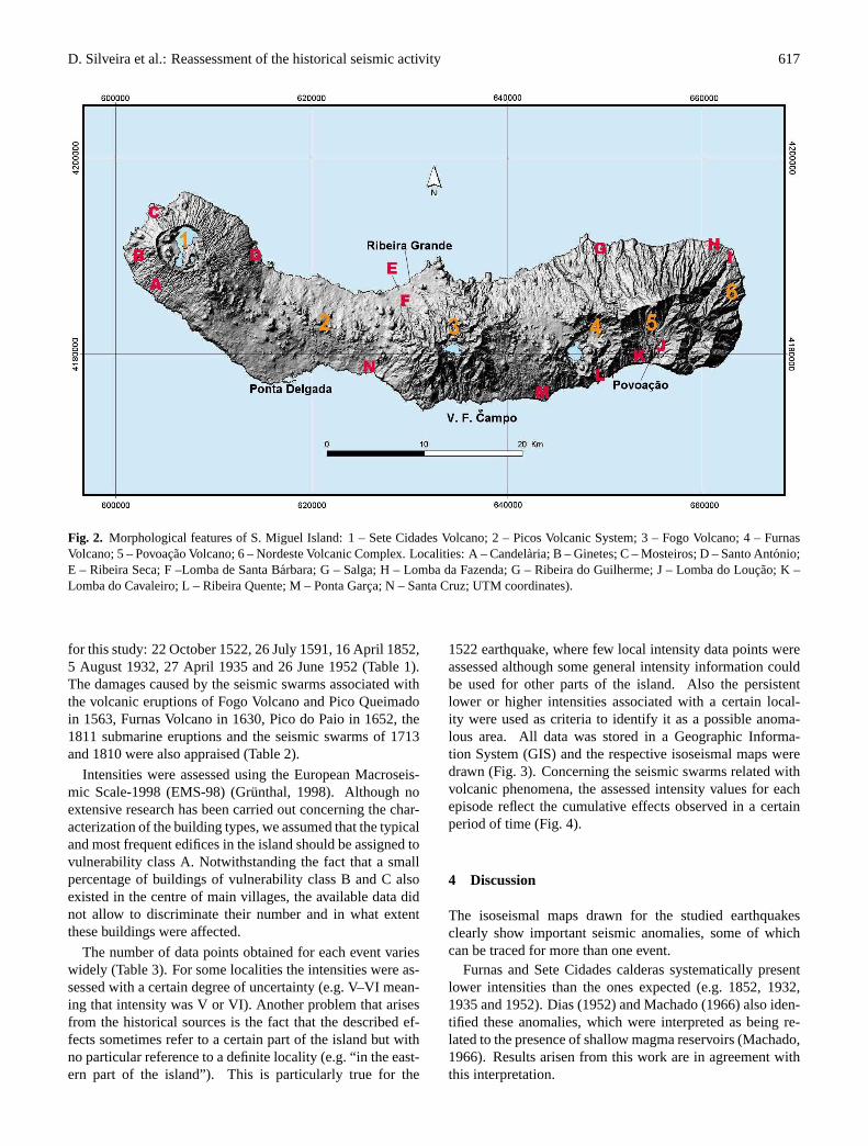
S. Miguel Island is located in the eastern segment of theTerceira Rift, showing a high diversity of volcanic and tec-tonic structures that includes three active trachytic centralvolcanoes with caldera (Sete Cidades, Fogo and Furnas) em-placed in the intersection of the NW–SE to WNW–ESE re-gional faults with an E–W deep fault system thought to bea relic of a MAR transform fault (Queiroz, 1997) (Fig. 2).N–S and NE–SW faults also occur in this context. Severalcinder cones alignments link those major volcanic structuresalong NW–SE to WNW–ESE fractures. The easternmost partof the island comprises an inactive trachytic central volcano(Povoacao) and an old basaltic volcanic complex (Nordeste).
Strong earthquakes have struck S. Miguel Island severaltimes throughout more than five hundred years of history.Using the available historical documents and previous stud-ies we reassessed the seismic intensities for the major eventsapplying the European Macroseismic Scale-1998 (EMS-98).This allowed the investigation of the existence and origin ofseismic intensity anomalies; relocate some of the proposedepicentres, and to produce the maximum historical seismicintensities map for the island.
616 D. Silveira et al.: Reassessment of the historical seismic activity
Fig. 1 – Geographical location, tectonic setting and instrumental seismicity (1980-2001) of the Azores archipelago. Seismic data from SIVISA (2001). Bathymetry from Lourenço et al. (1998). Legend: MAR – Mid-Atlantic Ridge; EAFZ – East Azores Fracture Zone; TR – Terceira Rift; GF – Gloria Fault.
Fig. 1. Geographical location, tectonic setting and instrumental seismicity (1980–2001) of the Azores archipelago. Seismic data fromSIVISA (2001). Bathymetry from Lourenco et al. (1998). Legend: MAR – Mid-Atlantic Ridge; EAFZ – East Azores Fracture Zone; TR –Terceira Rift; GF – Gloria Fault.
2 Historical data
Despite some uncertainties about its discovery, it is knownthat the settlement of the Azores by the Portuguese startedin the 2nd quarter of the 15th century. Historical documentsreporting the natural hazards that have taken place in theAzores are dispersed in several libraries and archives. Thefirst step was the gathering of copies of all the availablehistorical documents, including individual chronicles, offi-cial reports, newspaper accounts and press notes. Since thetime of the settlement until the middle of the 18th century,the main sources of information were the chronicles writ-ten by Azorean priests (e.g. Frutuoso, 1522–1591†; Cha-gas, 1576–16??†; Monte Alverne, 1629–1726†; Cordeiro,1641–1722†; Maldonado, 1644–1711†). Later on several au-thors compiled short descriptions about seismic and volcanicevents, creating what can be considered as the earliest seis-mic catalogues of the archipelago (Mendonca, 1758; Araujo,1801; Webster, 1821; Abranches 1877; Canto, 1878–1888;Bessone, 1932; Barata et al., 1989). After 1850 the mainsources used were local newspapers. Macroseismic data ofevents that occurred in the 20th century as well as previousworks done by several authors were also used (e.g. Chaves,
1915; Agostinho, 1936, 1960; A.S.P., 1952; Dias, 1952; Fer-reira, 1956; Silva, 1956; Costa Nunes et al., 1986; Cole etal., 1995; Queiroz, 1997; Wallenstein et al., 1998; Guest etal., 1999; Ferreira, 2000). The historical documents were or-ganized and stored in a digital format to integrate the AzoresSeismological Data Base.
The information found in historical records was oftenqualitative and sometimes misleading due to the use of dif-ferent terms to characterise the same kind of effects as wellas archaic expressions no longer of current use in Portuguese.Thus, a glossary was prepared in order to minimize misun-derstandings. For some of the studied cases, the availabledata didn’t allow to discriminate between damages producedeither by seismic ground shaking or phenomena such as vol-canic tremor, volcanic explosions or landslides. This wasparticularly true for the cases of the seismic swarms relatedwith volcanic activity.
3 Studied cases
Among the major tectonic earthquakes that affectedS. Miguel Island since its settlement, six events were selected
D. Silveira et al.: Reassessment of the historical seismic activity 617
Fig. 2. Morphological features of S. Miguel Island: 1 – Sete Cidades Volcano; 2 – Picos Volcanic System; 3 – Fogo Volcano; 4 – FurnasVolcano; 5 – Povoacao Volcano; 6 – Nordeste Volcanic Complex. Localities: A – Candelaria; B – Ginetes; C – Mosteiros; D – Santo Antonio;E – Ribeira Seca; F –Lomba de Santa Barbara; G – Salga; H – Lomba da Fazenda; G – Ribeira do Guilherme; J – Lomba do Loucao; K –Lomba do Cavaleiro; L – Ribeira Quente; M – Ponta Garca; N – Santa Cruz; UTM coordinates).
for this study: 22 October 1522, 26 July 1591, 16 April 1852,5 August 1932, 27 April 1935 and 26 June 1952 (Table 1).The damages caused by the seismic swarms associated withthe volcanic eruptions of Fogo Volcano and Pico Queimadoin 1563, Furnas Volcano in 1630, Pico do Paio in 1652, the1811 submarine eruptions and the seismic swarms of 1713and 1810 were also appraised (Table 2).
Intensities were assessed using the European Macroseis-mic Scale-1998 (EMS-98) (Grunthal, 1998). Although noextensive research has been carried out concerning the char-acterization of the building types, we assumed that the typicaland most frequent edifices in the island should be assigned tovulnerability class A. Notwithstanding the fact that a smallpercentage of buildings of vulnerability class B and C alsoexisted in the centre of main villages, the available data didnot allow to discriminate their number and in what extentthese buildings were affected.
The number of data points obtained for each event varieswidely (Table 3). For some localities the intensities were as-sessed with a certain degree of uncertainty (e.g. V–VI mean-ing that intensity was V or VI). Another problem that arisesfrom the historical sources is the fact that the described ef-fects sometimes refer to a certain part of the island but withno particular reference to a definite locality (e.g. “in the east-ern part of the island”). This is particularly true for the
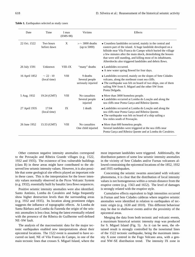
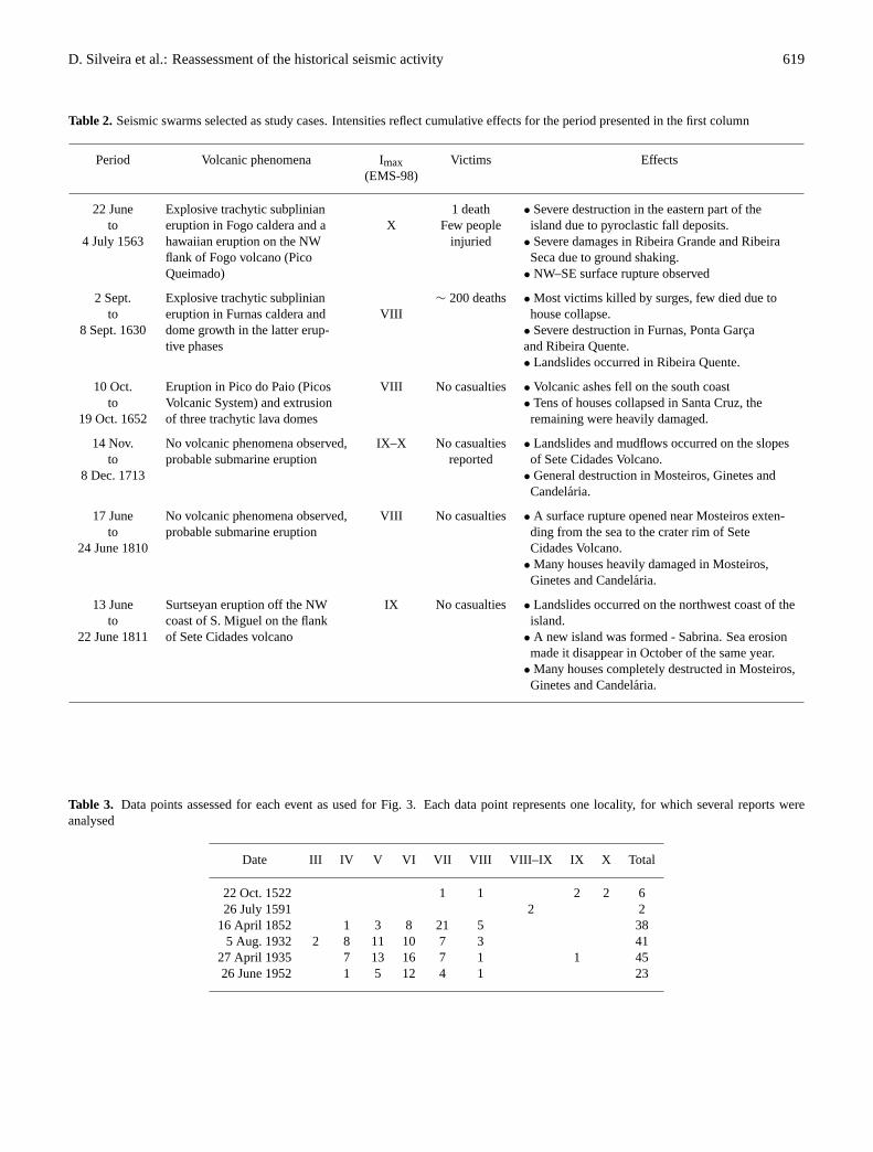
1522 earthquake, where few local intensity data points wereassessed although some general intensity information couldbe used for other parts of the island. Also the persistentlower or higher intensities associated with a certain local-ity were used as criteria to identify it as a possible anoma-lous area. All data was stored in a Geographic Informa-tion System (GIS) and the respective isoseismal maps weredrawn (Fig. 3). Concerning the seismic swarms related withvolcanic phenomena, the assessed intensity values for eachepisode reflect the cumulative effects observed in a certainperiod of time (Fig. 4).
4 Discussion
The isoseismal maps drawn for the studied earthquakesclearly show important seismic anomalies, some of whichcan be traced for more than one event.
Furnas and Sete Cidades calderas systematically presentlower intensities than the ones expected (e.g. 1852, 1932,1935 and 1952). Dias (1952) and Machado (1966) also iden-tified these anomalies, which were interpreted as being re-lated to the presence of shallow magma reservoirs (Machado,1966). Results arisen from this work are in agreement withthis interpretation.
618 D. Silveira et al.: Reassessment of the historical seismic activity
Table 1. Earthquakes selected as study cases
Date Time I max Victims Effects(EMS-98)
22 Oct. 1522 Two hours X >∼ 3000 deaths • Countless landslides occurred, mainly in the central andbefore dawn (up to 5000) eastern part of the island. A huge landslide developed on a
hillside near Vila Franca do Campo which buried the villagea few minutes after the main shock, demolishing the housesthat were still standing, and killing most of its inhabitants.Aftershocks also triggered landslides and debris flows.
26 July 1591 Unknown VIII–IX “many” deaths • Landslides occurred.• A new water spring flowed for four days.
16 April 1852 ∼ 22 : 10 VIII 9 deaths • Landslides occurred, mainly on the slopes of Sete Cidades(local time) Several people volcano, along the northeast coast sea cliffs.
seriously injuried • The earthquake was felt on board of two ships, one of themsailing NW from S. Miguel and the other SW fromPonta Delgada.
5 Aug. 1932 19:24 (GMT) VIII No casualties • More than 3000 homeless people.Several people • Landslides occurred at Lomba do Loucao and along the
injuried sea cliffs near Ponta Garca and Ribeira Quente.
27 April 1935 17:04 IX 1 death • Landslides occurred at Lomba do Loucao and along the(local time) sea cliffs near Ponta Garca and Ribeira Quente.
• The earthquake was felt on board of a ship sailing afew miles south of Povoacao.
26 June 1952 15:33 (GMT) VIII No casualties • More than 600 homeless people.One child injuried Several landslides were triggered at the sea cliffs near
Ponta Garca and Ribeira Quente and at Lomba do Cavaleiro.
Other common negative intensity anomalies correspondto the Povoacao and Ribeira Grande villages (e.g. 1522,1932 and 1935). The existence of less vulnerable buildings(class B) in these areas might have contributed to the ob-served low seismic intensity values. However, it is also possi-ble that some geological site effects played an important rolein these cases. This is the interpretation for the lower inten-sity values normally observed in the Picos Volcanic System(e.g. 1932), essentially built by basaltic lava flows sequences.
Positive seismic intensity anomalies were also identified.Santo Antonio, Lomba do Cavaleiro and Salga frequentlyshow higher destruction levels than the surrounding areas(e.g. 1932 and 1935). Its location along prominent ridgessuggests the influence of topographic effects. At Lomba deSanta Barbara and Lomba da Fazenda the origin of the seis-mic anomalies is less clear, being the latest eventually relatedwith the presence of the Ribeira do Guilherme well-definedNE–SW fault.
The analysis of the macroseismic data for the major tec-tonic earthquakes enabled new interpretations about theirepicentral locations. The 1522 event is assumed to have oc-curred on land, NE of Vila Franca do Campo, in one of themain tectonic lines that crosses S. Miguel Island, where the
most important landslides were triggered. Additionally, thedistribution pattern of some low seismic intensity anomaliesin the vicinity of Sete Cidades and/or Furnas volcanoes al-lowed constraining the epicentral locations of the 1852, 1932and 1935 earthquakes.
Concerning the seismic swarms associated with volcanicphenomena, it is clear that the distribution of local intensityvalues is not homogeneous within a certain distance from theeruptive centre (e.g. 1563 and 1652). The level of damagesis strongly related with the eruptive style.
Cumulative effects equivalent to high intensities occurredin Furnas and Sete Cidades calderas where negative seismicanomalies were identified in relation to earthquakes of tec-tonic origin (e.g. 1630 and 1810). This different behaviourmay be due to shallower events and/or the proximity of theepicentral areas.
Merging the data from both tectonic and volcanic events,a maximum historical seismic intensity map was producedfor S. Miguel Island (Fig. 5). As it can be seen, the ob-tained result is strongly controlled by the isoseismal linesof the 1522 tectonic earthquake, being the maximum inten-sity X zone centred in the Fogo Volcano area, with a gen-eral NW–SE distribution trend. The intensity IX zone in
D. Silveira et al.: Reassessment of the historical seismic activity 619
Table 2. Seismic swarms selected as study cases. Intensities reflect cumulative effects for the period presented in the first column
Period Volcanic phenomena Imax Victims Effects(EMS-98)
22 June Explosive trachytic subplinian 1 death • Severe destruction in the eastern part of theto eruption in Fogo caldera and a X Few people island due to pyroclastic fall deposits.
4 July 1563 hawaiian eruption on the NW injuried • Severe damages in Ribeira Grande and Ribeiraflank of Fogo volcano (Pico Seca due to ground shaking.Queimado) • NW–SE surface rupture observed
2 Sept. Explosive trachytic subplinian ∼ 200 deaths • Most victims killed by surges, few died due toto eruption in Furnas caldera and VIII house collapse.
8 Sept. 1630 dome growth in the latter erup- • Severe destruction in Furnas, Ponta Garcative phases and Ribeira Quente.
• Landslides occurred in Ribeira Quente.
10 Oct. Eruption in Pico do Paio (Picos VIII No casualties• Volcanic ashes fell on the south coastto Volcanic System) and extrusion • Tens of houses collapsed in Santa Cruz, the
19 Oct. 1652 of three trachytic lava domes remaining were heavily damaged.
14 Nov. No volcanic phenomena observed, IX–X No casualties• Landslides and mudflows occurred on the slopesto probable submarine eruption reported of Sete Cidades Volcano.
8 Dec. 1713 • General destruction in Mosteiros, Ginetes andCandelaria.
17 June No volcanic phenomena observed, VIII No casualties• A surface rupture opened near Mosteiros exten-to probable submarine eruption ding from the sea to the crater rim of Sete
24 June 1810 Cidades Volcano.• Many houses heavily damaged in Mosteiros,Ginetes and Candelaria.
13 June Surtseyan eruption off the NW IX No casualties• Landslides occurred on the northwest coast of theto coast of S. Miguel on the flank island.
22 June 1811 of Sete Cidades volcano • A new island was formed - Sabrina. Sea erosionmade it disappear in October of the same year.
• Many houses completely destructed in Mosteiros,Ginetes and Candelaria.
Table 3. Data points assessed for each event as used for Fig. 3. Each data point represents one locality, for which several reports wereanalysed
Date III IV V VI VII VIII VIII–IX IX X Total
22 Oct. 1522 1 1 2 2 626 July 1591 2 2
16 April 1852 1 3 8 21 5 385 Aug. 1932 2 8 11 10 7 3 41
27 April 1935 7 13 16 7 1 1 4526 June 1952 1 5 12 4 1 23
620 D. Silveira et al.: Reassessment of the historical seismic activity
Fig. 3 – Isoseismal maps drawn for the studied earthquakes: - epicentre; black dots – urban areas; * - insufficient data to draw isoseismal lines, epicentre probably off the south coast of the island.
1522
1935 1952
1852 1932
1591*
Fig. 3. Isoseismal maps drawn for the studied earthquakes: green dots - epicentres; black dots - urban areas; * - insufficient data to drawisoseismal lines, epicentre probably off the south coast of the island.
the western part of the island is the result of the seismic ac-tivity that accompanied the volcanic episodes offshore SeteCidades Volcano.
5 Conclusions
The study of historical documents related with the destruc-tive earthquakes that have stricken S. Miguel Island revealedto be an important tool for seismic risk assessment. Newinsights about the epicentral location of major events con-tributed to evaluate the active character of main tectonic linesand highlight seismogenic areas not defined yet by the shorttime period of instrumental seismicity in the archipelago.
The results of macroseismic studies based on historicalrecords are useful as a first approach to set guidelines for thedevelopment of future works. This is the case for the identi-fied seismic intensity anomalous areas, where further studiesshould be carried out in order to verify their origin and dis-cuss their implications in risk analysis. The studied cases
can also be used as possible scenarios to model the impactof future events and set up emergency and land use planningmeasures.
This kind of study should be extended to all the islandsof the archipelago to complement the instrumental seismicdata information. Tectonic, paleoseismological and geologi-cal surveys should be carried out to identify field evidencesof fault movements related with the studied historical earth-quakes.

D. Silveira et al.: Reassessment of the historical seismic activity 621
Fig. 4 – Local intensity maps for the studied seismic swarms. For some localities the intensities were assessed with a certain degree of uncertainty (e.g. III-IV meaning that intensity was III or IV). - eruptive centres; black dots – urban areas.
1630
1810 1811
17131652
1563
Fig. 4. Local intensity maps for the studied seismic swarms. For some localities the intensities were assessed with a certain degree ofuncertainty (e.g. III–IV meaning that intensity was III or IV).4N – eruptive centres; black dots - urban areas.
Fig. 5 - Maximum historical intensity map of S. Miguel island using the EMS-98 (black dots – urban areas).
Fig. 5. Maximum historical intensity map of S. Miguel Island using the EMS-98 (black dots – urban areas).
622 D. Silveira et al.: Reassessment of the historical seismic activity
References
Abranches, J. C.: Convulsoes da Terra, 1a ed. Ponta Delgada: Ty-pographia de Manoel Correa Botelho, 212, 1877.
Agostinho, J.: Tectonica, sismicidade e vulcanismo das ilhas dosAcores, Acoreana, Angra do Heroısmo, Vol.I: 2, 86–98, 1936.
Agostinho, J.: Actividade vulcanica nos Acores, Acoreana, Angrado Heroısmo, 5, 362–478, 1960.
A.S.P.: Anuario Sismologico de Portugal, Dir. H. Amorim Ferreira,N◦ 6 – Ano de 1952, Lisboa: Servico Meteorologico Nacional,I, 1955.
Araujo, L. A.: Memoria chronologica dos tremores mais no-taveis e irrupcoes de fogo, acontecidos nas ilhas dos Acores:com a relacao dos tremores que houverao nesta ilha Terceira...Acrescenta-se a noticia de hum fenomeno observado no dia 25de Junho.... 1a ed. Lisboa: Thypographia Chalcographica e Lit-teraria do Arco do Cego, 24, 1801.
Barata, M. R. T., Braga, M. L., Wagner, M. N., Guerra, B.,Alves, J. F., and Neto, J.: Sismicidade de Portugal: estudo dadocumentacao dos seculos XVII e XVIII - apendice documental,1a ed. Lisboa: Gabinete de Proteccao e Seguranca Nuclear doMinisterio do Planeamento e da Administracao do Territorio, II,336, 1989.
Bessone, P.: Dicionario cronologico dos Acores, 1a ed. Cambridge,Massachusetts, USA: Edicao do autor, 446, 1932.
Canto, E.: Vulcanismo nos Acores, Arquivo dos Acores, Ponta Del-gada: Universidade dos Acores, I: (1878); II: (1880); III: (1881);V: (1883); IX: (1887); XI: (1890).
Chagas, Fr. D.: 1576–16??†- Espelho cristalino em jardim de variasflores, 1a ed. (Angra do Heroısmo)(Ponta Delgada): DireccaoRegional dos Assuntos Culturais: Centro de Estudos Doutor Gas-par Frutuoso da Universidade dos Acores, 731, 1989.
Chaves, F. A.: Erupcoes submarinas nos Acores: informacoes queos navegantes podem prestar sobre tal assunto. 1a ed. Lisboa:Tipografia d’A Modesta, 47, 1915.
Cole, P. D., Queiroz, G., Wallenstein, N., Gaspar, J. L., Duncan, A.M., and Guest, J. E.: An historic subplinian / phreatomagmaticeruption: the 1630 AD eruption of Furnas volcano, Sao Miguel,Azores, J. of Volcanology and Geothermal Res., Amsterdam 69,117–135, 1995.
Cordeiro, A.: Historia insulana das ilhas a Portugal sugeytas nooceano occidental, 3a Ed. (reimpressao fac-similada da 1a ed.de 1717) Regiao Autonoma dos Acores: Secretaria Regional daEducacao e Cultura, 528, 1981.
Costa Nunes, J., Martins, A., and Oliveira, C. S.: Sismicidadehistorica e instrumental do arquipelago dos Acores: sismossentidos no perıodo 1444–1980, Catalogo preliminar, RelatorioINMG/LNEC: 1986, (nao paginado), 1986.
Dias, A. A. M.: Os sismos de 26 de Junho de 1952 e a sismicidadede S. Miguel, Ponta Delgada: (s.n.), 10, 1952.
Ferreira, H. A.: Macrossismos sentidos em Portugal no perıodo de1901–1954, Boletim da Ordem dos Engenheiros, Lisboa, V, N◦
1, Memoria N◦ 128, 1–10, 1956.Ferreira, T.: Caracterizacao da actividade vulcanica da ilha de
S. Miguel (Acores): vulcanismo basaltico recente e zonas dedesgasificacao, Avaliacao de riscos, Ponta Delgada: Departa-mento de Geociencias da Universidade dos Acores, Tese deDoutoramento em Geologia na especialidade de Vulcanologia,247, 2000.
Frutuoso, G.: 1522–1591†: Livro Quarto das Saudades da Terra,In Frutuoso, G. –�Saudades da Terra�. 2a ed. Ponta Delgada:Instituto Cultural de Ponta Delgada, II, 1981.
Grunthal, G., (ed.): European Macroseismic Scale 1998, Cahiers duCentre Europeen de Geodynamique et de Seismologie, Luxem-bourg, 15, 1–99, 1998.
Guest, J. E., Gaspar, J. L., Cole, P. D., Queiroz, G., Duncan, A. M.,Wallenstein, N., Ferreira, T., and Pacheco, J. M.: Volcanic geol-ogy of Furnas Volcano, Sao Miguel, Azores, J. Volcanol., Ams-terdam, 92, 1–29, 1999.
Krause, D.: East and West Azores Fracture-Zones in the NorthAtlantic, in: Submarine geology and geophysics, (Eds.) Wit-thard, W. E. and Bradshaw, R., London Butterworths Publ., 163–172, 1965.
Krause, D. and Watkins, N.: North Atlantic crustal genesis in thevicinity of the Azores, Geophys. J. of the Royal Astron. Soc.,UK, 19, 261–283, 1970.
Laughton, A. and Whitmarsh, R.: The Azores-Gibraltar plateboundery, in: Geodinamics of Iceland and the North AtlanticArea, Kristjansson, L., 1a ed. Dordrecht, Holland: D. Reidel,63–81, 1974.
Lourenco, N., Miranda, J. M., Luis, J. F., Ribeiro, A., Mendes Vic-tor, L. A., Madeira, J., and Needham, H. D.: Morpho-tectonicanalysis of the Azores Volcanic Plateau from a new bathymetriccompilation of the area, Marine Geophys. Res., Netherlands, 20,141–156, 1998.
Luıs, J.: Le plateau des Acores et le point triple associe: analysegeophysique etevolution, Paris: Universite Paris VII, These deDoctorat, specialite Geophysique Interne, 196, 1996.
Machado, F.: Submarine pits of the Azores plateau, Bull. Volcanol.,Serie II, Tome XXI, 109–116, 1959.
Machado, F.: Anomalias das intensidades do terramoto deS. Miguel (Acores) em 1522, Boletim do Museu e LaboratorioMineralogico e Geologico da Faculdade de Ciencias, Lisboa, 10,2, 109–117, 1966.
Madeira, J.: Estudos de neotectonica nas ilhas do Faial, Pico eS. Jorge: uma contribuicao para o conhecimento geodinamicoda juncao tripla dos Acores, Lisboa: Departamento de Geolo-gia da Faculdade de Ciencias da Universidade de Lisboa, Tesede Doutoramento em Geologia na especialidade de GeodinamicaInterna, 428, 1998.
Madeira, J. and Ribeiro, A.: Geodynamic models for the Azorestriple junction: a contribution from tectonics, Tectonophysics,UK, 184, 405–415, 1990.
Maldonado, Pe. M. L.: 1644–1711†: Fenix angrence, 1a ed. Angrado Heroısmo: Instituto Historico da Ilha Terceira, V 2◦, 717,1990.
McKenzie, D. P.: Active tectonics of the Mediterranean region,Geophys. J. of the Royal Astronom. Soc., UK, 30, 109–185,1972.
Mendonca, J. J. M.: Historia universal dos terramotos que temhavido no Mundo, de que ha noticia, desde a sua creacao ateo seculo presente: com huma narracam individual do terremotodo primeiro de Novembro de 1755... e huma dissertacao phisicasobre as causas geraes dos terremotos.... 1a ed. Lisboa: Offic. deAntonio Vicente da Silva, (12), 272, 1758.
Miranda, J. L., Mendes Victor, L. A., Simoes, J. Z., Luıs, J. F.,Matias, L., Shimamura, H., Shiobara, H., Nemoto, H.,Mochizuki, H., Hirn, A., and Lepine, J. C.: Tectonic setting ofthe Azores Plateau deduced from a OBS survey, Marine Geo-phys. Res., Netherlands, 20, 171–182, 1998.
Monte Alverne, A.: 1629–1726†: Cronicas da Provıncia de S. JoaoEvangelista das Ilhas dos Acores, 1a ed. Ponta Delgada: InstitutoCultural de Ponta Delgada, II, 520, 1961.
Queiroz, G.: Vulcao das Sete cidades (S. Miguel, Acores): historia
D. Silveira et al.: Reassessment of the historical seismic activity 623
eruptiva e avaliacao do hazard, Ponta Delgada: Departamento deGeociencias da Universidade dos Acores, Tese de Doutoramentoem Geologia na especialidade de Vulcanologia, 226, 1997.
Ribeiro, A.: Tectonica de placas: aplicacao a sismotectonica eaevolucao da fronteira de placas Acores-Gibraltar, Geonovas, Lis-boa, 1:4, 87–98, 1982.
Searle, R.: Tectonic pattern of the Azores spreading centre andtriple junction, Earth and Planetary Science Letters, Amsterdam,51, 415–434, 1980.
SIVISA: Carta de Sismicidade dos Acores, no perıodo de 1980 a2001, 2002.
Silva, M. A. V.: Apontamentos duma visitaa ilha de S. Miguel paraestudo dos efeitos os abalos sısmicos de 5 de Agosto de 1932 e
27 de Abril de 1935, Boletim da Ordem dos Engenheiros, Lisboa,V, N◦ 4, Memoria n◦ 142, 1–8, 1956.
SREA: Servico Regional de Estatıstica dos Acores, Censos 2001.Steinmetz, L., Hirn, A., Sapin, M., Whitmarsh, R., Moreira, V.:
Zone of P Wave attenuation beneath the crest of Mid-AtlanticRidge, Bull Soc. Geol. France, N◦ 4.
Wallenstein, N., Duncan, A. M., Almeida, H., and Pacheco, J.:A Erupcao de 1563 do Pico do Sapateiro, S. Miguel (Acores)Procedings da 1a Assembleia Luso-Espanhola de Geodesia eGeofısica (CD-ROM), Almeria, Espanha, (1998).
Webster, J.: A description of the St. Michael, 1st ed. Boston:R. P.&C. Williams Ed., 1821.