historical perspective on seismic hazard to hispaniola and ... · subducts under the puerto rico...
TRANSCRIPT

Historical perspective on seismic hazard to Hispaniolaand the northeast Caribbean region
Uri S. ten Brink,1 William H. Bakun,2 and Claudia H. Flores1
Received 29 April 2011; revised 7 October 2011; accepted 11 October 2011; published 29 December 2011.
[1] We evaluate the long-term seismic activity of the North-American/Caribbean plateboundary from 500 years of historical earthquake damage reports. The 2010 Haitiearthquakes and other earthquakes were used to derive regional attenuation relationshipsbetween earthquake intensity, magnitude, and distance from the reported damage to theepicenter, for Hispaniola and for Puerto Rico and the Virgin Islands. The attenuationrelationship for Hispaniola earthquakes and northern Lesser Antilles earthquakes is similarto that for California earthquakes, indicating a relatively rapid attenuation of damageintensity with distance. Intensities in Puerto Rico and the Virgin Islands decrease lessrapidly with distance. We use the intensity-magnitude relationships to systematicallysearch for the location and intensity magnitude MI which best fit all the reporteddamage for historical earthquakes. Many events occurred in the 20th-century along theplate-boundary segment from central Hispaniola to the NW tip of Puerto Rico, but earlierevents from this segment were not identified. The remaining plate boundary to the eastto Guadeloupe is probably not associated with M > 8 historical subduction-zoneearthquakes. The May 2, 1787 earthquake, previously assigned an M 8–8.25, is probablyonly MI 6.9 and could be located north, west or SW of Puerto Rico. An MI 6.9 earthquakeon July 11, 1785 was probably located north or east of the Virgin Islands. We locatedMI < 8 historical earthquakes on April 5, 1690, February 8, 1843, and October 8, 1974 inthe northern Lesser Antilles within the arc. We speculate that the December 2, 1562(MI 7.7) and May 7, 1842 (MI 7.6) earthquakes ruptured the Septentrional Fault in northernHispaniola. If so, the recurrence interval on the central Septentrional Fault is �300 years,and only 170 years has elapsed since the last event. The recurrence interval of largeearthquakes along the Hispaniola subduction segment is likely longer than the historicalrecord. Intra-arc M ≥ 7.0 earthquakes may occur every 75–100 years in the 410-km-longsegment between the Virgin Islands and Guadeloupe.
Citation: ten Brink, U. S., W. H. Bakun, and C. H. Flores (2011), Historical perspective on seismic hazard to Hispaniola and thenortheast Caribbean region, J. Geophys. Res., 116, B12318, doi:10.1029/2011JB008497.
1. Introduction
[2] Hydrodynamic models show that large earthquakes onthe North America/Caribbean subduction zone have thepotential to cause trans-oceanic tsunamis that will impact theU.S. East Coast, western Europe, and the nearby Caribbeanislands [e.g.,Geist and Parsons, 2009]. Although the potentialmagnitude of intra-arc (i.e., above the subduction zone)Caribbean earthquakes may be smaller than subduction-zone events, the seismic risk may be greater because of theirshallow depth and proximity to Caribbean-region populationcenters. The 500-year written history of the Caribbean includesaccounts of devastating earthquakes, volcanic eruptions, andtsunamis [Perrey, 1857] that can be used to quantify the seis-mic hazard of the region.
[3] The Caribbean islands were discovered and named byColumbus in 1492–1498 [Morison, 1942] and were quicklypopulated, first by Spanish and then by other nationalities.European migration to these islands and the internationalstruggle over the control of the islands and the sea routesduring the 16th–18th centuries, have resulted in rich writtenrecords in the form of bureaucratic reports and letters fromthe islands to the mother countries. These reports and letterssometimes include descriptions of damages from hurricanesand earthquakes, often accompanied by requests for moneyto rebuild damaged property (e.g., de Utrera [1995], quotingArchivo General de las Indias, Santo Domingo, AGI-IG 95).The record is most complete in Hispaniola (present-day Haitiand the Dominican Republic) and Puerto Rico, which weresettled at the end of the 15th century; records are sparser andstart later in the smaller islands.[4] In this paper we compile reports of damage by signif-
icant earthquakes in Hispaniola, Puerto Rico, the VirginIslands, and the northern Lesser Antilles in the past 500 yearsto understand the long-term seismic activity of the trench and
1U.S. Geological Survey, Woods Hole, Massachusetts, USA.2U.S. Geological Survey, Menlo Park, California, USA.
This paper is not subject to U.S. copyright.Published in 2011 by the American Geophysical Union.
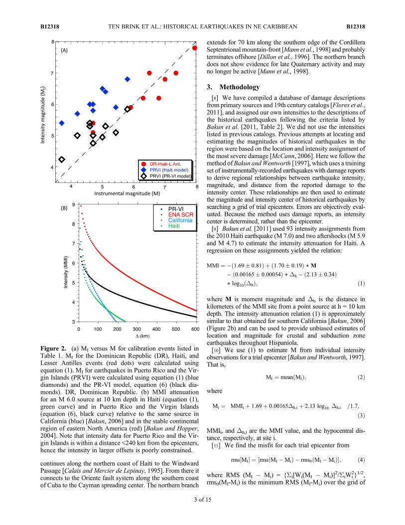
JOURNAL OF GEOPHYSICAL RESEARCH, VOL. 116, B12318, doi:10.1029/2011JB008497, 2011
B12318 1 of 15
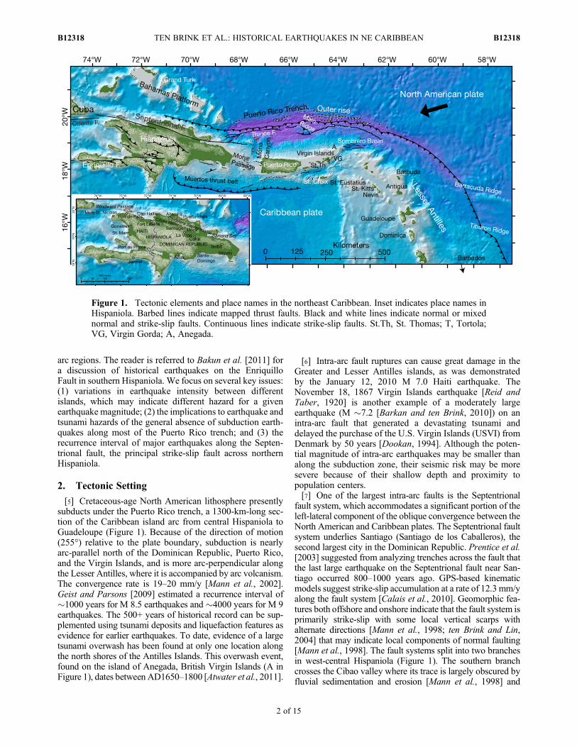
arc regions. The reader is referred to Bakun et al. [2011] fora discussion of historical earthquakes on the EnriquilloFault in southern Hispaniola. We focus on several key issues:(1) variations in earthquake intensity between differentislands, which may indicate different hazard for a givenearthquake magnitude; (2) the implications to earthquake andtsunami hazards of the general absence of subduction earth-quakes along most of the Puerto Rico trench; and (3) therecurrence interval of major earthquakes along the Septen-trional fault, the principal strike-slip fault across northernHispaniola.
2. Tectonic Setting
[5] Cretaceous-age North American lithosphere presentlysubducts under the Puerto Rico trench, a 1300-km-long sec-tion of the Caribbean island arc from central Hispaniola toGuadeloupe (Figure 1). Because of the direction of motion(255°) relative to the plate boundary, subduction is nearlyarc-parallel north of the Dominican Republic, Puerto Rico,and the Virgin Islands, and is more arc-perpendicular alongthe Lesser Antilles, where it is accompanied by arc volcanism.The convergence rate is 19–20 mm/y [Mann et al., 2002].Geist and Parsons [2009] estimated a recurrence interval of�1000 years for M 8.5 earthquakes and �4000 years for M 9earthquakes. The 500+ years of historical record can be sup-plemented using tsunami deposits and liquefaction features asevidence for earlier earthquakes. To date, evidence of a largetsunami overwash has been found at only one location alongthe north shores of the Antilles Islands. This overwash event,found on the island of Anegada, British Virgin Islands (A inFigure 1), dates between AD1650–1800 [Atwater et al., 2011].
[6] Intra-arc fault ruptures can cause great damage in theGreater and Lesser Antilles islands, as was demonstratedby the January 12, 2010 M 7.0 Haiti earthquake. TheNovember 18, 1867 Virgin Islands earthquake [Reid andTaber, 1920] is another example of a moderately largeearthquake (M �7.2 [Barkan and ten Brink, 2010]) on anintra-arc fault that generated a devastating tsunami anddelayed the purchase of the U.S. Virgin Islands (USVI) fromDenmark by 50 years [Dookan, 1994]. Although the poten-tial magnitude of intra-arc earthquakes may be smaller thanalong the subduction zone, their seismic risk may be moresevere because of their shallow depth and proximity topopulation centers.[7] One of the largest intra-arc faults is the Septentrional
fault system, which accommodates a significant portion of theleft-lateral component of the oblique convergence between theNorth American and Caribbean plates. The Septentrional faultsystem underlies Santiago (Santiago de los Caballeros), thesecond largest city in the Dominican Republic. Prentice et al.[2003] suggested from analyzing trenches across the fault thatthe last large earthquake on the Septentrional fault near San-tiago occurred 800–1000 years ago. GPS-based kinematicmodels suggest strike-slip accumulation at a rate of 12.3 mm/yalong the fault system [Calais et al., 2010]. Geomorphic fea-tures both offshore and onshore indicate that the fault system isprimarily strike-slip with some local vertical scarps withalternate directions [Mann et al., 1998; ten Brink and Lin,2004] that may indicate local components of normal faulting[Mann et al., 1998]. The fault systems split into two branchesin west-central Hispaniola (Figure 1). The southern branchcrosses the Cibao valley where its trace is largely obscured byfluvial sedimentation and erosion [Mann et al., 1998] and
Figure 1. Tectonic elements and place names in the northeast Caribbean. Inset indicates place names inHispaniola. Barbed lines indicate mapped thrust faults. Black and white lines indicate normal or mixednormal and strike-slip faults. Continuous lines indicate strike-slip faults. St.Th, St. Thomas; T, Tortola;VG, Virgin Gorda; A, Anegada.
TEN BRINK ET AL.: HISTORICAL EARTHQUAKES IN NE CARIBBEAN B12318B12318
2 of 15
continues along the northern coast of Haiti to the WindwardPassage [Calais and Mercier de Lepinay, 1995]. From there itconnects to the Oriente fault system along the southern coastof Cuba to the Cayman spreading center. The northern branch
extends for 70 km along the southern edge of the CordilleraSeptentrional mountain-front [Mann et al., 1998] and probablyterminates offshore [Dillon et al., 1996]. The northern branchdoes not show evidence for late Quaternary activity and mayno longer be active [Mann et al., 1998].
3. Methodology
[8] We have compiled a database of damage descriptionsfrom primary sources and 19th century catalogs [Flores et al.,2011], and assigned our own intensities to the descriptions ofthe historical earthquakes following the criteria listed byBakun et al. [2011, Table 2]. We did not use the intensitieslisted in previous catalogs. Previous attempts at locating andestimating the magnitudes of historical earthquakes in theregion were based on the location and intensity assignment ofthe most severe damage [McCann, 2006]. Here we follow themethod ofBakun andWentworth [1997], which uses a trainingset of instrumentally-recorded earthquakes with damage reportsto derive regional relationships between earthquake intensity,magnitude, and distance from the reported damage to theintensity center. These relationships are then used to estimatethe magnitude and intensity center of historical earthquakes bysearching a grid of trial epicenters. Errors are objectively eval-uated. Because the method uses damage reports, an intensitycenter is determined, rather than the epicenter.[9] Bakun et al. [2011] used 93 intensity assignments from
the 2010 Haiti earthquake (M 7.0) and two aftershocks (M 5.9and M 4.7) to estimate the intensity attenuation for Haiti. Aregression on these assignments yielded the relation:
MMI ¼ � 1:69� 0:81ð Þ þ 1:70� 0:19ð Þ * M
� 0:00165� 0:00054ð Þ * Dh � 2:13� 0:34ð Þ* log10 Dhð Þ; ð1Þ
where M is moment magnitude and Dh is the distance inkilometers of the MMI site from a point source at h = 10 kmdepth. The intensity attenuation relation (1) is approximatelysimilar to that obtained for southern California [Bakun, 2006](Figure 2b) and can be used to provide unbiased estimates oflocation and magnitude for crustal and subduction zoneearthquakes throughout Hispaniola.[10] We use (1) to estimate M from individual intensity
observations for a trial epicenter [Bakun andWentworth, 1997].That is,
MI ¼ mean Mið Þ; ð2Þ
where
Mi ¼ MMIi þ 1:69þ 0:00165Dh;i þ 2:13 log10 Dh;i
� �� �=1:7;
ð3Þ
MMIi, and Dh,i are the MMI value, and the hypocentral dis-tance, respectively, at site i.[11] We find the misfit for each trial epicenter from
rms MI½ � ¼ rms MI �Mið Þ � rms0 MI �Mið Þ½ �; ð4Þ
where RMS (MI � Mi) = {Si[Wi(MI � Mi)]2/SiWi
2}1/2,rms0(MI-Mi) is the minimum RMS (MI-Mi) over the grid of
Figure 2. (a) MI versus M for calibration events listed inTable 1. MI for the Dominican Republic (DR), Haiti, andLesser Antilles events (red dots) were calculated usingequation (1). MI for earthquakes in Puerto Rico and the Vir-gin Islands (PRVI) were calculated using equation (1) (bluediamonds) and the PR-VI model, equation (6) (black dia-monds). DR, Dominican Republic. (b) MMI attenuationfor an M 6.0 source at 10 km depth in Haiti (equation (1),green curve) and in Puerto Rico and the Virgin Islands(equation (6), black curve) relative to the same source inCalifornia (blue) [Bakun, 2006] and in the stable continentalregion of eastern North America (red) [Bakun and Hopper,2004]. Note that intensity data for Puerto Rico and the Vir-gin Islands is within a distance <240 km from the epicenters,hence the intensity in larger offsets is poorly constrained.
TEN BRINK ET AL.: HISTORICAL EARTHQUAKES IN NE CARIBBEAN B12318B12318
3 of 15
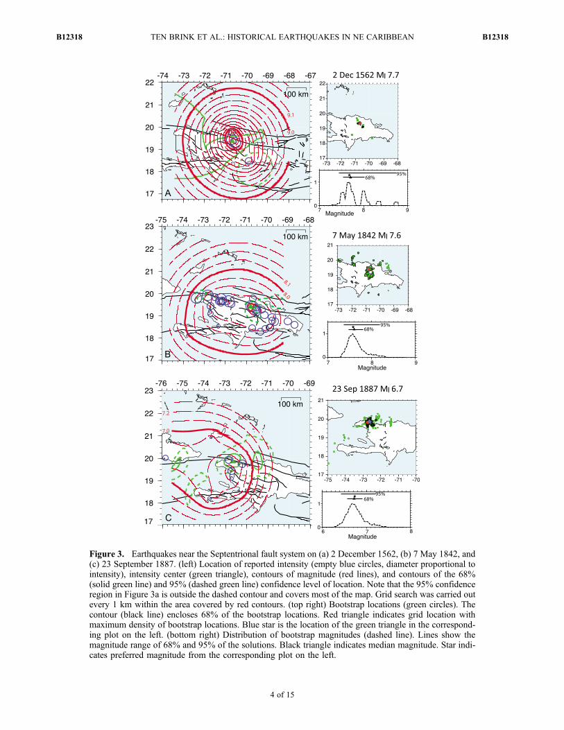
Figure 3. Earthquakes near the Septentrional fault system on (a) 2 December 1562, (b) 7 May 1842, and(c) 23 September 1887. (left) Location of reported intensity (empty blue circles, diameter proportional tointensity), intensity center (green triangle), contours of magnitude (red lines), and contours of the 68%(solid green line) and 95% (dashed green line) confidence level of location. Note that the 95% confidenceregion in Figure 3a is outside the dashed contour and covers most of the map. Grid search was carried outevery 1 km within the area covered by red contours. (top right) Bootstrap locations (green circles). Thecontour (black line) encloses 68% of the bootstrap locations. Red triangle indicates grid location withmaximum density of bootstrap locations. Blue star is the location of the green triangle in the correspond-ing plot on the left. (bottom right) Distribution of bootstrap magnitudes (dashed line). Lines show themagnitude range of 68% and 95% of the solutions. Black triangle indicates median magnitude. Star indi-cates preferred magnitude from the corresponding plot on the left.
TEN BRINK ET AL.: HISTORICAL EARTHQUAKES IN NE CARIBBEAN B12318B12318
4 of 15
trial epicenters, and Wi is the distance-weighting function[Bakun and Wentworth, 1997]
Wi ¼ 0:1þ cos Di=150ð Þ p=2ð Þ½ � for Di < 150 kmf0:1 for Di > 150 km ð5Þ
The preferred intensity center (green triangle in Figures 3–6)is the trial source location for which RMS [MI] is minimum[Bakun, 1999] and corresponds more to the moment centroidthan to the epicenter. Red contours are magnitudes MI. TheMI contours bound the intensity center region and are asso-ciated with confidence levels that the epicenter is locatedwithin the contour (heavy and dashed green lines) [Bakun
and Wentworth, 1997]. The MI at the intensity center is thebest estimate of moment magnitude M for that earthquake.Uncertainties in M appropriate for the number of intensityassignments are also estimated at the 68% and 95% confi-dence levels (Table 2) [Bakun and Wentworth, 1999].[12] The bootstrap data resampling strategy has been
developed to provide estimates of the uncertainty of modelparameters estimated from a given finite data set. In thebootstrap re-sampling strategy, n random samples are drawnwith replacement from a set of n observations. For example,consider a data set with three observations: A, B, and C. Forthe data set, there are 9 possible bootstrap resampling sets:AAA; BBB; CCC; AAB; AAC; ABB; ACC; BBC; and BCC.The bootstrap resampling approach is particularly usefulbecause it has been shown [Efron, 1982] that the statisticalproperties of the family of bootstrap resampled sets is iden-tical to the statistical properties of the original data set. For adata set of 4 points, such as the1562 earthquake (Figure 3a),the variance may be larger than the expected value, so thebootstrap method may not be very reliable. The bootstrapresampling distributions for location and magnitude arepresented in Figures 3–6. We interpret divergence in thelocations and magnitudes between the bootstrap analysis andthe original grid search to indicate solutions that are notwell constrained.
4. Results: Variations in Intensity Attenuation
[13] We used 19 modern earthquakes in the NE Caribbeanwith intensity assignments (Table 1) to test the Haiti attenu-ation model (equation (1)) across the region. Intensityassignments for events after the year 2000 are taken from theUSGS Earthquake Hazards Program (Did you Feel It (DYFI),http://earthquake.usgs.gov/dyfi) as real numbers, not roundedintegers. DYFI questionnaires were designed to match thedescriptions of MMI intensities and are assumed to be equiv-alent (D.Wald, written communication, 2011). Damage reportsfrom events before 2000 were compiled from different sources[Bodle and Murphy, 1984; Coffman and von Hake, 1984a;Coffman and Stover, 1984; Coffman and von Hake, 1984b;Stover and Brewer, 1991]. The number of locations of intensityreports for these calibration events varies from 3 to 55. Earth-quakes in Hispaniola and the northern Lesser Antilles span awide magnitude range (M 4.3–7.6; Ms where Mw is not avail-able). Calibration events from Puerto Rico and the VirginIslands span a more limited magnitude range (M 3.4–5.8).[14] Intensity magnitudes, MI, obtained with equation (1)
for earthquakes in Hispaniola and the northern Lesser Antil-les are consistent with Mw (Figure 2a). That is, the Haitiintensity attenuation relationship (equation (1)) is appropriatefor earthquakes throughout Hispaniola and for earthquakes inthe northern Lesser Antilles. The MI calculated using theHaiti intensity attenuation relation are larger than the instru-mental magnitudes of earthquakes near Puerto Rico and theVirgin Islands by about 1.0 magnitude units (Figure 2a). Theconsistency of the magnitude mismatch suggests that the Haitiintensity attenuation is not appropriate for earthquakes nearPuerto Rico and the Virgin Islands.[15] We therefore used regression analysis for the Puerto
Rico and Virgin Islands (PR-VI) events to obtain an intensity
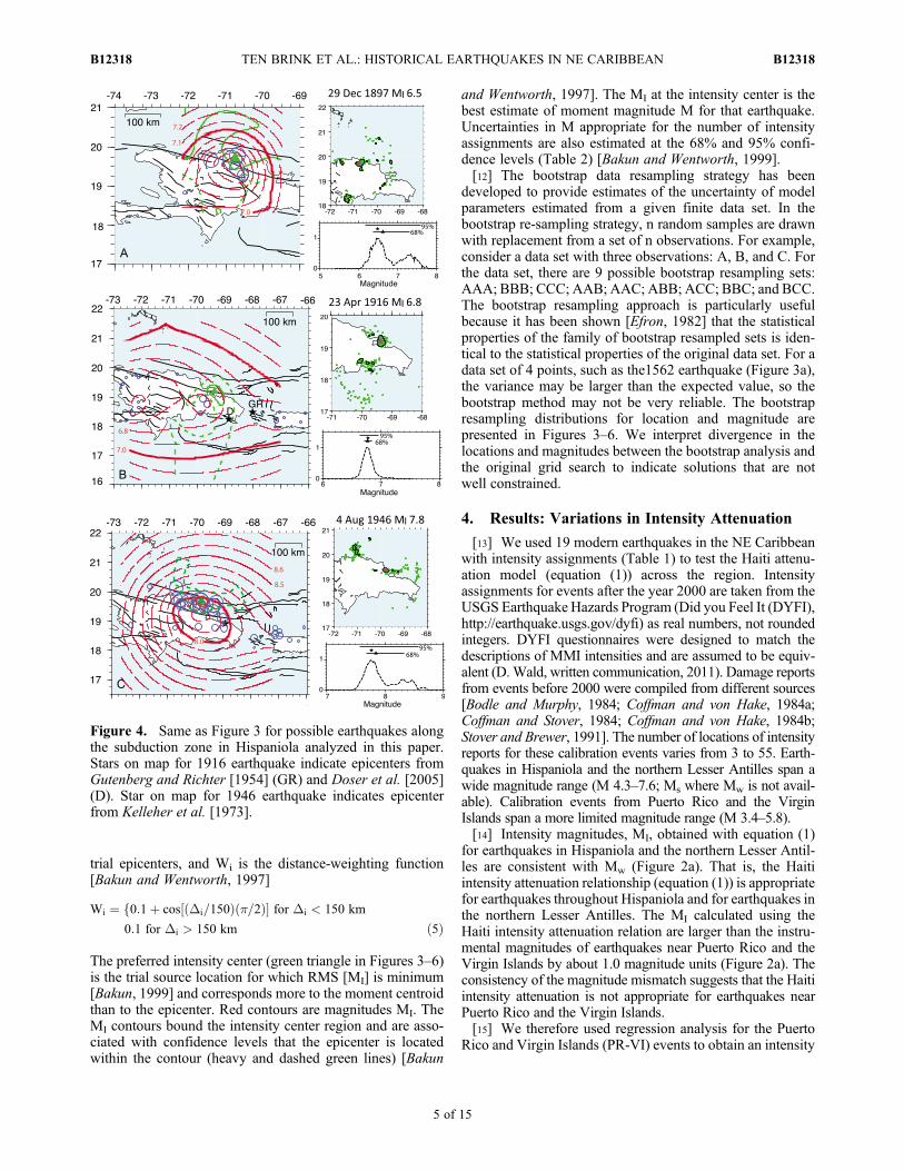
Figure 4. Same as Figure 3 for possible earthquakes alongthe subduction zone in Hispaniola analyzed in this paper.Stars on map for 1916 earthquake indicate epicenters fromGutenberg and Richter [1954] (GR) and Doser et al. [2005](D). Star on map for 1946 earthquake indicates epicenterfrom Kelleher et al. [1973].
TEN BRINK ET AL.: HISTORICAL EARTHQUAKES IN NE CARIBBEAN B12318B12318
5 of 15

attenuation model that appears to be appropriate for PuertoRico and the Virgin Islands
MMI ¼ �1:06þ 1:45*M� 0:00136*Dh � 1:3*log10 Dhð Þ; ð6Þ
The calculated MI using (6) are consistent with the instru-mental magnitudes for M ≥ 5.0 earthquakes there (Table 1).For M < 5.0, MI tends to over-estimate the earthquake mag-nitude, and this may be due to either an inaccurate intensitymodel or to the inaccuracy in the instrumental magnitudes forthe small earthquakes. We assume that equation (6) is alsoappropriate for larger (M > 6) earthquakes in Puerto Rico andthe Virgin Islands. The individual MMI residuals (observedMMI – calculated MMI) on average do not depend on epi-central distance, providing an independent support for therelationship in equation (6).[16] The intensity attenuation relation for PRVI earth-
quakes, equation (6), is intermediate between the intensityattenuation relation for the eastern United States (ENA-SCR)and California (Figure 2b). For a given earthquake magni-tude, the intensity drops off with increasing distance moreslowly in Puerto Rico and the Virgin Islands than for His-paniola and the Lesser Antilles (Figure 2b). The PRVI model
is consistent with the Quality Factor (Q) for Puerto Ricobeing intermediate between that for California and easternNorth America [Motazedian and Atkinson, 2005]. Their Qwas derived from modern M 3.0–5.5 earthquakes.
5. Analysis of Historical Earthquakes
5.1. Hispaniola and Mona Passage
[17] The first reported severe earthquake in Hispaniola tookplace in what is now the northern Dominican Republic in 1562(de Utrera [1995], citing primary sources). The date of thisearthquake is controversial. A date of November 2, 1564,mentioned in an undated letter by Echagoian to King Philip IIof Spain, was later adopted by others [Charlevoix, 1731; delMonte y Tejada, 1890; García, 1900; Moreau de Saint-Méry, 1796; Poey, 1857; Scherer, 1912; Southey, 1827;McCann, 2006]. García [1900] also mentioned April 20,1564. De Utrera [1995] noticed the discrepant 1562 and 1564dates and argued that Echagioan wrote his letter in early 1568after leaving Hispaniola. De Utrera [1995, pp. 17–18] con-sulted the Archivo General de Indias (AGI) in Seville andwrote “In the Indies Archives can be found the followingpapers: Letter from the honorable Herrera to His Majesty, in
Figure 5. Same as Figure 3 for earthquakes in Puerto Rico and the Virgin Islands.
TEN BRINK ET AL.: HISTORICAL EARTHQUAKES IN NE CARIBBEAN B12318B12318
6 of 15
his Real Consejo de Indias, over various matters and amongthem news of an earthquake that occurred December 2 of theyear before, which is dated February 16, 1563. Another letterdated February 13, 1563 co-written by the Honorable Herreraand the Honorable Echagoian and by the doctor Caceres to HisMajesty, in their Real Consejo de Indias, over the earthquakethat occurred on December 2 of the year before, between eightand nine at night, which resulted in the fall of the Catheral de la
Vega. Another letter from the clergyman Cabildo from Con-ception to His Majesty in his Real Consejo de Indias, over thedestruction caused by the earthquake of December 2, 1562,and is a letter that contains the date October 6, 1563.” Wefollow de Utrera [1995] in assigning the date of December 2,1562 to the earthquake.[18] The 1562 earthquake completely destroyed Santiago
de Los Caballeros [del Monte y Tejada, 1890]. That town was
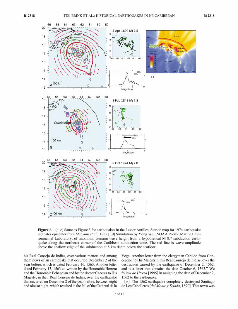
Figure 6. (a–c) Same as Figure 3 for earthquakes in the Lesser Antilles. Star on map for 1974 earthquakeindicates epicenter fromMcCann et al. [1982]. (d) Simulation by Yong Wei, NOAA Pacific Marine Envi-ronmental Laboratory, of maximum tsunami wave height from a hypothetical M 8.7 subduction earth-quake along the northeast corner of the Caribbean subduction zone. The red line is wave amplitudeabove the shallow edge of the subduction at 5 km depth below the seafloor.
TEN BRINK ET AL.: HISTORICAL EARTHQUAKES IN NE CARIBBEAN B12318B12318
7 of 15
located on the Septentrional fault trace [Mann et al., 1998]and was subsequently abandoned and rebuilt 10 km to theSE. Most of the city of Concepcion de La Vega (also knownas La Vega), 35 km SE of present-day Santiago wasdestroyed [Moreau de Saint Méry, 1796], and the city wasabandoned. The church and Franciscan monastery, whichwere built of masonry, partly reinforced by iron bars, werealmost completely destroyed [Scherer, 1912]. The conventand dormitory in Puerto Plata, the only brick and stonebuildings in that town, were severely damaged [de Utrera,1995], as were several buildings in Santo Domingo thatwere built of weak masonry [de Utrera, 1995].[19] We could not find damage reports from eight addi-
tional towns that are shown on a map from that era [Ortelius,1579] as having churches, monasteries, or other types oflarge buildings. Only one of these towns (Puerto Real, 12 kmSE of Cap Haitien) was located along the northern part of theisland, and there is no archeological evidence for severedamage during the 1562 earthquake. However, the town wasforcibly burned and abandoned in 1578 by the Spanishauthorities because of the failure of the population to restrictcontraband trade, so it is difficult to identify earthquakedamage occurring 16 years earlier (K. Deagan, writtencommunication, 2011). An eyewitness on a ship at MonteCristi 100 km west of Santiago saw the earth shake ashore in1562 (AGI -IG 1002, 13 May 1563).[20] Our intensity location for the 1562 earthquake is
between Santiago and La Vega about 15 km south of theSeptentrional fault near Moca, and the intensity magnitudeMI is 7.7 (Figure 3a). Bootstrap analysis gives similar pre-ferred location and magnitude estimates, but also allows foran alternative location 20 km to the southeast.[21] Damage from several earthquakes during the
17th century was reported in Santo Domingo and old Azua(Table 2). Reports for these events are generally available
only from these towns, probably because of the abandon-ment of the northern and western coasts of Hispaniola in1606 by a decree of the king of Spain [Charlevoix, 1731;Southey, 1827; García, 1900], and the general decline inSpanish population during the 17th century. On the otherhand, there were still a total of 13 towns in central, south-ern, and eastern Hispaniola during that time [Charlevoix,1731], and a map of Hispaniola [Mercator, 1628] shows4 towns with stone churches or other buildings in south andsoutheast Hispaniola, 4 in north-central Hispaniola, and 4 inthe Cordillera Central. French settlement, in what is nowHaiti, started around 1670 [Charlevoix, 1731]. In any case,the locations and magnitudes of the MI 6.5–7.5 earthquakesin 1615, 1665, 1673, 1684, and 1691 (Table 2) cannot beconfidently determined with the available data, but theyappear to have occurred near the south coast of theDominican Republic.[22] The May 7, 1842 earthquake caused extensive dam-
age all along northern Hispaniola [Ardouin, 1860, p. 222]:“In a minute at most, the cities of Cap Haitien, Port-de-Paix,Mole St. Nicolas, Fort Liberté and Saint-Yague (Santiago)became a heap of rubble. In Cap Haitien, it lost about 5,000souls half of the population; in Port-de-Paix about 200; atSaint-Yague (Santiago) 200; in other places a little less.”Based on newspaper reports (L’Ami de la religion, June 28,1842; The Public Ledger, July 15, 1842; Journal de laDrome, June 22, 1842; el Constitusional, July 9, 1842) and acompilation of damage by Scherer [1912], we estimate thehighest intensity (IX) to have been in Fort Liberté, CapHaitien, Port de-Paix, and Mole Saint Nicolas along thenorthern coast of Haiti and in Santiago and Hato del Yaque(8 km west of Santiago) in north-central Dominican Repub-lic. The intensity was also high (VIII) in Puerto Plata, and inLa Vega, 30 km north and 30 km southeast of Santiago,respectively, and in Monte Cristi (VII-VIII). The earthquake
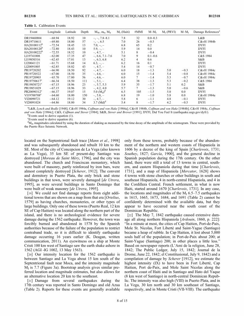
Table 1. Calibration Events
Event Longitude Latitude Depth MW, mb, MS MI (Haiti) #MMI M–MI MI (PRVI) M–MI Damage Referencesa
DR19460804 �68.94 18.92 10 –, –, 7.8–8.1 7.8 32 0.0–0.3 L&BDR19710611 �69.80 18.00 57 –, –, 6.5 7.0 26 �0.5 C&vH 1984bHA20100112b �72.54 18.45 13 7.0, –, – 6.8 65 0.2 DYFIHA20100120b �72.80 18.43 10 5.9, –, – 5.9 14 0.0 DYFIHA20100222b �72.55 18.52 10 –, 4.7, – 5.1 8 �0.4 DYFILI19741008 �62.00 17.35 47 –, 6.6, 7.1–7.6 7.0 9 0.1–0.6 C&S 1984LI19850316 �62.45 17.01 13 –, 6.3, 6.8 6.2 4 0.6 S&BLI20041121 �61.71 15.68 14 6.3, –, – 6.2 16 0.1 DYFILI20091005 �62.85 18.02 43 –, 4.7, – 5.4 14 �0.7 DYFIPR19720202 �66.90 18.50 92 –, 4.7, – 6.0 18 �1.3 5.0 �0.3 C&vH 1984cPR19720522 �67.00 18.50 35 –, 4.6, – 6.0 15 �1.4 5.4 �0.8 C&vH 1984cPR19720903 �65.70 17.80 56 –, 4.6, – 6.0 7 �1.4 5.3 �0.7 C&vH 1984cPR19750617c �66.34 18.50 111 –, 5.1, – 6.4 38 �1.3 5.3 �0.2 C&S 1984PR19850721c �67.15 18.96 23 –, 5.7, 5.3 5.9 35 �1.7 5.1 0.2 S&BPR19851029 �67.15 18.96 33 –, 4.2, 4.0 5.7 7 �1.3 5.0 �0.6 S&BPR20090312c �66.37 19.07 15 5.0 (Md)
d 6.5 105 �1.5 5.0 0.0 DYFIVI19700708c �64.60 18.00 150 –, 5.8, – 6.8 19 �1.0 5.8 0.0 C&vH 1984aVI20090721 �64.12 19.12 30 –, 4.7, – 5.8 6 �1.1 4.8 �0.1 DYFIVI20091024 �64.86 18.80 34 3.7 (Md)d 5.4 8 �1.7 4.2 �0.5 DYFI
aL&B, Lynch and Bodle [1948]; C&vH 1984a, Coffman and von Hake [1984a]; C&vH 1984b, Coffman and von Hake [1984b]; C&vH 1984c, Coffmanand von Hake [1984c]; C&S, Coffman and Stover [1984]; S&B, Stover and Brewer [1991]; DYFI, Did You Feel It (earthquake.usgs.gov/dyfi/).
bEvents used to derive equation (1).cEvents used to derive equation (6).dMd, magnitudes calculated by using the duration of shaking as measured by the time decay of the amplitude of the seismogram. These were provided by
the Puerto Rico Seismic Network.
TEN BRINK ET AL.: HISTORICAL EARTHQUAKES IN NE CARIBBEAN B12318B12318
8 of 15
intensity diminished to the west to V in Santiago de Cuba andIII in Jamaica. To the east, the intensity continued to be high(VII) within the area 50 km east of Santiago in the DominicanRepublic, and in easternmost Dominican Republic (VI-VII inHiguey and Seibo), and decreased to V in western PuertoRico. The intensity decreased more rapidly south and northof the fault zone. To the south, we estimate intensity VII atCotui, Dominican Republic, VI 1/2 in Santo Domingo, VII atGonaives, Haiti, VI at St. Marc, Haiti, V at Port Au Prince,and III–IV in the southern Peninsula of Haiti. North of thefault zone, we estimate IV at Cockburn Town, Turks andCaicos. Aftershocks were felt fromMayaguez, Puerto Rico toPort-au-Prince, Haiti [Flores et al., 2011].[23] The intensity center of the 1842 earthquake is 10 km
west of Santiago and its intensity magnitude MI is 7.6(Figure 3b). Bootstrap analysis gives similar magnitude andlocation, but also permits alternate locations (Figure 3b).[24] The last moderately large earthquake located on or
near the Septentrional fault took place on September 23,1887. Damage was most severe at Mole St. Nicolas at thenorthwestern tip of Haiti, where liquefaction and perhaps atsunami occurred [Tippenhauer, 1893; Scherer, 1912].Damage was less severe at Port de Paix, Cap Haitien, andGonaives to the east, and Santiago de Cuba to the west. Theearthquake was felt in Manzanillo, Cuba, and Kingston,Jamaica to the west [Le Gaulois, 1887; The New York Times,1887; Hall, 1922]. Damage was mentioned but not specifiedin Santo Domingo [Scherer, 1912]. We have assignedintensities only to damage levels from ground shaking, notground failure and tsunami. Damage at Mole St. Nicholasappears to include liquefaction (ground failure) and/or tsu-nami damage, and has therefore been discarded from ouranalysis. In a solution that excludes the reports from MoleSt. Nicholas, the intensity center is on or near the Septentri-onal fault between Port de Paix and Cap Haitien, with MI 6.7(Figure 3c), but a solution that includes Mole St. Nicholas(intensity VIII) gives an intensity center in the Dominican
Republic and MI 7.2. There are no damage reports related tothis earthquake from the Dominican Republic.[25] Several significant earthquakes occurred along the
north coast of Hispaniola and Mona Passage starting in 1897.The December 29, 1897 earthquake caused serious damage innorth-central Hispaniola, including “irreparable damage” tothe governor’s residence, a cathedral, and a chapel in Santiago[Agamennone, 1898], and to the cathedral in Altamira [TheNew York Times, 1898]. It destroyed buildings in PuertoPlata and damaged the railroad there (Tomblin and Robson[1977], quoting Jamaica Post, 1898). The submarine cabletore in Puerto Plata [Agamennone, 1898]. The 1897 earth-quake was felt in south and SW Hispaniola (Jacmel, Port AuPrince, Santo Domingo). The intensity center is near PuertoPlata, 10 km south of the northern Dominican Republic coast,andMI is 6.5 (Figure 4a).Abe [1994] proposed an instrumentalmagnitude 6.8 and an epicenter located 250 km to the south-west, but instrumental locations from that time can be a fewhundreds of kilometers in error (W. H. K. Lee, personalcommunication, 2011). The 1897 event is similar in size andlocation to the September 12, 2003 Mw 6.4 Puerto Platashallow thrust earthquake [Dolan and Bowman, 2004].[26] The April 23, 1916 23:36L (April 24, 1916 04:26:42 UT)
earthquake occurred in a sparsely populated area at thenortheast tip of Hispaniola, resulting in relatively little dam-age. However, the earthquake was felt from St. Thomas,USVI, in the east to Grand Turk Island in the northwest, Port-de-Paix, in northwestern Haiti, and to the southern coast ofthe southern Peninsula of Haiti, roughly 350–450 km fromthe earthquake location. Our analysis places the earthquakeunder Samana Peninsula with MI 6.8 (Figure 4b). Gutenbergand Richter [1954] located the earthquake 160 km to the SEin the middle of Mona Passage at a depth of 80 km(Figure 4b). They determined a magnitude of mB7.0. Doseret al. [2005] estimated a magnitude Mw 6.8 and a reversefault mechanism with location at the SE tip of Hispaniola(Figure 4b) at a depth of 16� 7 km. Instrumental locations of
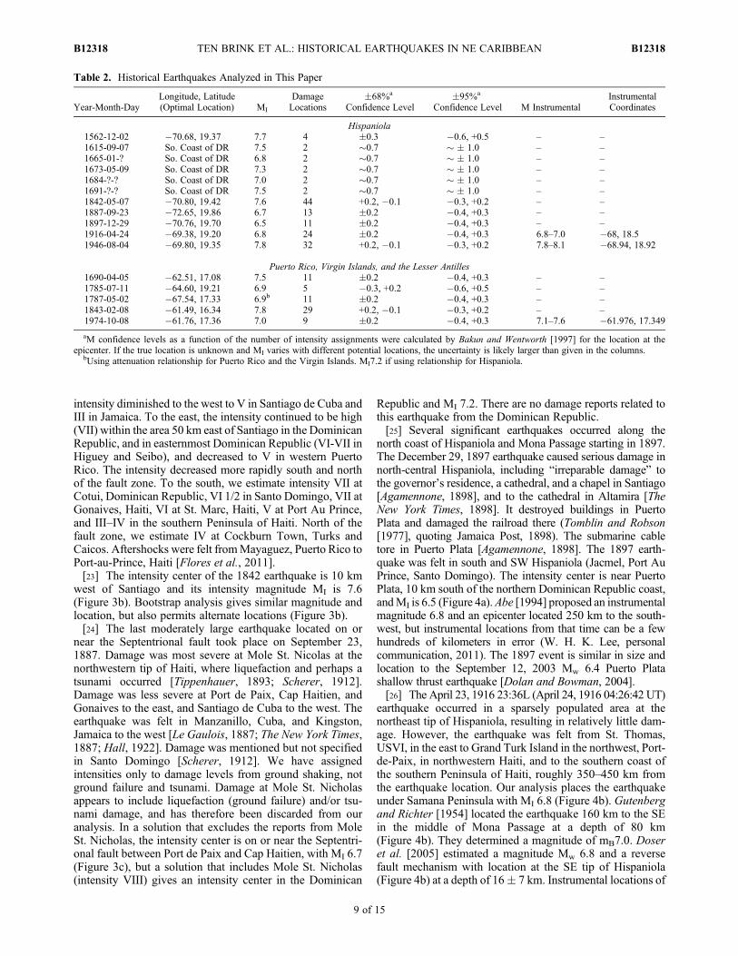
Table 2. Historical Earthquakes Analyzed in This Paper
Year-Month-DayLongitude, Latitude(Optimal Location) MI
DamageLocations
�68%a
Confidence Level�95%a
Confidence Level M InstrumentalInstrumentalCoordinates
Hispaniola1562-12-02 �70.68, 19.37 7.7 4 �0.3 �0.6, +0.5 – –1615-09-07 So. Coast of DR 7.5 2 �0.7 � � 1.0 – –1665-01-? So. Coast of DR 6.8 2 �0.7 � � 1.0 – –1673-05-09 So. Coast of DR 7.3 2 �0.7 � � 1.0 – –1684-?-? So. Coast of DR 7.0 2 �0.7 � � 1.0 – –1691-?-? So. Coast of DR 7.5 2 �0.7 � � 1.0 – –1842-05-07 �70.80, 19.42 7.6 44 +0.2, �0.1 �0.3, +0.2 – –1887-09-23 �72.65, 19.86 6.7 13 �0.2 �0.4, +0.3 – –1897-12-29 �70.76, 19.70 6.5 11 �0.2 �0.4, +0.3 – –1916-04-24 �69.38, 19.20 6.8 24 �0.2 �0.4, +0.3 6.8–7.0 �68, 18.51946-08-04 �69.80, 19.35 7.8 32 +0.2, �0.1 �0.3, +0.2 7.8–8.1 �68.94, 18.92
Puerto Rico, Virgin Islands, and the Lesser Antilles1690-04-05 �62.51, 17.08 7.5 11 �0.2 �0.4, +0.3 – –1785-07-11 �64.60, 19.21 6.9 5 �0.3, +0.2 �0.6, +0.5 – –1787-05-02 �67.54, 17.33 6.9b 11 �0.2 �0.4, +0.3 – –1843-02-08 �61.49, 16.34 7.8 29 +0.2, �0.1 �0.3, +0.2 – –1974-10-08 �61.76, 17.36 7.0 9 �0.2 �0.4, +0.3 7.1–7.6 �61.976, 17.349
aM confidence levels as a function of the number of intensity assignments were calculated by Bakun and Wentworth [1997] for the location at theepicenter. If the true location is unknown and MI varies with different potential locations, the uncertainty is likely larger than given in the columns.
bUsing attenuation relationship for Puerto Rico and the Virgin Islands. MI7.2 if using relationship for Hispaniola.
TEN BRINK ET AL.: HISTORICAL EARTHQUAKES IN NE CARIBBEAN B12318B12318
9 of 15
earthquakes from that time can be 100–200 km in errorbecause of the small number of recording stations, their poorfrequency range, and their large distance from the epicenter(W. H. K. Lee, personal communication, 2011). The intensityanalysis, on the other hand, is based on 24 nearby reportedlocations (Figure 4b).[27] M > 6.5 earthquakes continued in northern Hispaniola
and Mona Passage in the 20th century (Table 3). We ana-lyzed the August 4, 1946 earthquake, the largest of a seriesof six earthquakes (Ms 7.0–8.1) that occurred between 1943and 1953 along the subduction zone from central Hispaniolato the northwest corner of Puerto Rico [Dolan and Wald,1998; Kelleher et al., 1973]. Five of these events had pre-dominantly reverse mechanisms and are thought to representstress release on the subduction interface [Dolan and Wald,1998]. The epicenter of the M 7.8–8.1 August 4, 1946 waslocated on land 22 km south of the Septentrional strike-slipfault (Figure 4c) [Kelleher et al., 1973]. The earthquake wasaccompanied by a tsunami that drowned nearly 100 peopleis the village of Mantanzas [Lynch and Bodle, 1948] 100 kmto the west-northwest of the epicenter. The intensity centerfor this event is located at the tsunami location, �100 kmWNW of the instrumental epicenter (Figure 4c). The inten-sity magnitude is MI 7.8 � 0.2.
5.2. Puerto Rico and the Virgin Islands
[28] In contrast to the large earthquakes along northernHispaniola and Mona Passage, only moderate-size earthquakeshave occurred in the 20th century north of Puerto Rico and theVirgin Islands (http://www.globalcmt.org/CMTsearch.html)[Doser et al., 2005; Engdahl and Villaseñor, 2002]. The onlytwo known large earthquakes in this area occurred in 1785 and1787. McCann [1985] estimated an M 8–8.25 for the May 2,1787 earthquake and assumed a location in the Puerto Ricotrench. His magnitude estimate was based on reports of seriousdamage to masonry throughout Puerto Rico, particularly alongthe north shore [McCann et al., 2011]. It is difficult to locate thisearthquake, because it was felt only in Puerto Rico. The inten-sity center is near the Muertos Trough, southwest of the island(Figure 5a), although the most severe damage was reportedalong the northern coast of the island [McCann et al., 2011].
The solution was pushed away from the north coast of PuertoRico because of the mixture of lower and higher intensitiesthere, which perhaps reflects varying soil conditions. Thebootstrap analysis for this event locates the earthquake alongthe north coast, because it draws many subsets without thesmall intensities. Regardless, the solution in Figure 5a should beinterpreted as having almost equal probability to be located SWor north of the island. From geological considerations, onepossible intensity center is north-northeast of Puerto Rico underMain Ridge, an aseismic ridge that appears to have subductedstarting �3.3 m.y. ago [ten Brink, 2005]. Using equation (6),the intensity attenuation relationship for Puerto Rico and theVirgin Islands, MI is 6.9 for both a Muertos Trough and aMainRidge location (Figure 5a). Because the location is not wellconstrained, the magnitude could range from 6.4, if locatedunder the north coast of Puerto Rico, to 7.3, if located underthe outer rise north of the trench. Our analysis indicates thatthe magnitude of the 1787 earthquake was less than 7 1/2. Thisconclusion is qualitatively supported by the lack of felt ordamage reports from the surrounding islands [McCann et al.,2011].[29] The July 11, 1785 earthquake was felt most strongly
(MMI VI 1/2) in Virgin Gorda at the eastern end of theBritish Virgin Islands (BVI), less strongly in Tortola, BVI,and Antigua (MMI V), and least strongly in St. Kitts andSt Eustasia (MMI IV). An earthquake was felt that day innorthern Haiti [Moreau de Saint-Méry, 1796], but it is notclear whether it was the same earthquake. The earthquakemight have been accompanied by a tsunami, although thedescriptions are equivocal. In Spanish Town, Virgin Gorda,“there was uncommon agitation of the sea” (McCann et al.[2011], quoting the Times of London, 8 September 1785),and “The island of Tortola, which was swept over during thisconvulsion by an earthquake wave” [Shaler, 1869, p. 464].It is likely that the source was located north or northeastof the BVI because the earthquake was not reported feltin St. Croix, and was felt less strongly in the western vol-canic chain of the Lesser Antilles islands (St. Kitts andSt. Eustasia) than in the eastern (Antigua) and northernislands (BVI). Our preferred location is north of Tortolawith MI 6.9 (Figure 5b). Seafloor maps show large outer-
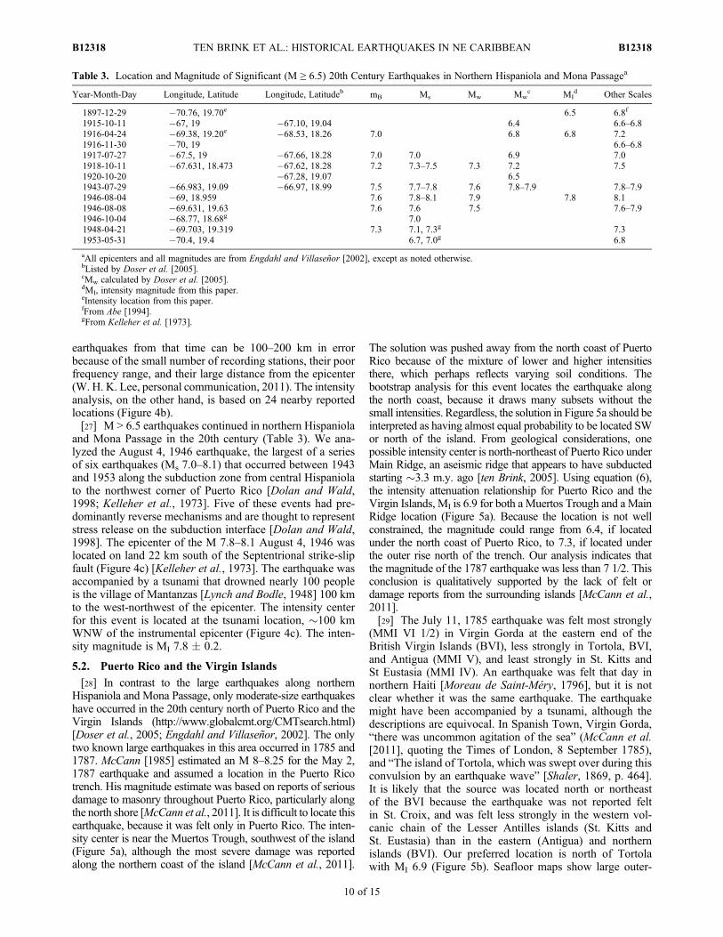
Table 3. Location and Magnitude of Significant (M ≥ 6.5) 20th Century Earthquakes in Northern Hispaniola and Mona Passagea
Year-Month-Day Longitude, Latitude Longitude, Latitudeb mB Ms Mw Mwc MI
d Other Scales
1897-12-29 �70.76, 19.70e 6.5 6.8f
1915-10-11 �67, 19 �67.10, 19.04 6.4 6.6–6.81916-04-24 �69.38, 19.20e �68.53, 18.26 7.0 6.8 6.8 7.21916-11-30 �70, 19 6.6–6.81917-07-27 �67.5, 19 �67.66, 18.28 7.0 7.0 6.9 7.01918-10-11 �67.631, 18.473 �67.62, 18.28 7.2 7.3–7.5 7.3 7.2 7.51920-10-20 �67.28, 19.07 6.51943-07-29 �66.983, 19.09 �66.97, 18.99 7.5 7.7–7.8 7.6 7.8–7.9 7.8–7.91946-08-04 �69, 18.959 7.6 7.8–8.1 7.9 7.8 8.11946-08-08 �69.631, 19.63 7.6 7.6 7.5 7.6–7.91946-10-04 �68.77, 18.68g 7.01948-04-21 �69.703, 19.319 7.3 7.1, 7.3g 7.31953-05-31 �70.4, 19.4 6.7, 7.0g 6.8
aAll epicenters and all magnitudes are from Engdahl and Villaseñor [2002], except as noted otherwise.bListed by Doser et al. [2005].cMw calculated by Doser et al. [2005].dMI, intensity magnitude from this paper.eIntensity location from this paper.fFrom Abe [1994].gFrom Kelleher et al. [1973].
TEN BRINK ET AL.: HISTORICAL EARTHQUAKES IN NE CARIBBEAN B12318B12318
10 of 15
rise normal faults northeast of the Virgin Islands [ten Brinket al., 2004]. If the earthquake occurred on one of thesefaults, its magnitude could have been as high as 7.2.
5.3. The Lesser Antilles
[30] Three large events have occurred in the northernLesser Antilles islands since Europeans settled these islandsin the first half of the 17th century. The April 5, 1690earthquake was felt from St. Thomas, USVI to Barbados. Itwas felt most strongly (IX) in Nevis and almost as stronglyin the adjacent islands of St. Kitts and Montserrat, all alongthe western chain of the Lesser Antilles and in Antigua onthe eastern chain. We located the earthquake near Nevis witha magnitude MI 7.5 (Figure 6a). The intensity center is280 km from the trench, where the slab interface is about200 km deep [Feuillet et al., 2002], suggesting that it mayhave been an intra-arc event and not a subduction zoneevent. Comparison of the locations of tsunami reports tolocations of predicted flooding also suggests that the 1690earthquake was not a subduction event. Tsunami modelingfrom a subduction zone event predicts significant floodingalong the trench-facing islands of Antigua and Barbuda(Figure 6d), where no flooding was reported (despite theseislands being populated at the time). In contrast, tsunamiwas reported from Charlotte Amelie on the south side ofSt. Thomas and in Nevis [O’Loughlin and Lander, 2003],where negligible flooding is expected from a subductionzone event (Figure 6d). Hence, the observations support anintra-arc origin for the 1690 earthquake.[31] The February 8, 1843 event was the largest historical
earthquake in the northern Lesser Antilles with an estimatedmagnitude of M 7.5–8 [Bernard and Lambert, 1988]. Weassigned MMI VIII-IX to damage reports from variouslocations in Guadeloupe and Antigua, and MMI VII-VIII todamage reports from various locations in St. Kitts, Nevis,and Dominica [Flores et al., 2011]. Although there was onetsunami report from Barbados, the earthquake did not pro-duce a tsunami or a noticeable vertical deformation inGuadeloupe or Antigua [Bernard and Lambert, 1988]. Usingour intensity assignments we determined an MI 7.8 with theintensity center located beneath Guadeloupe (Figure 6b).[32] The October 8, 1974 Ms 7.1 to 7.6 earthquake was
located near Barbuda on a southeast dipping normal faultabove the subduction zone [McCann et al., 1982]. Theintensity center is located within 10 km of McCann et al.’s[1982] epicenter with MI 7.0 (Figure 6c).
6. Discussion
6.1. Subduction Zone Events
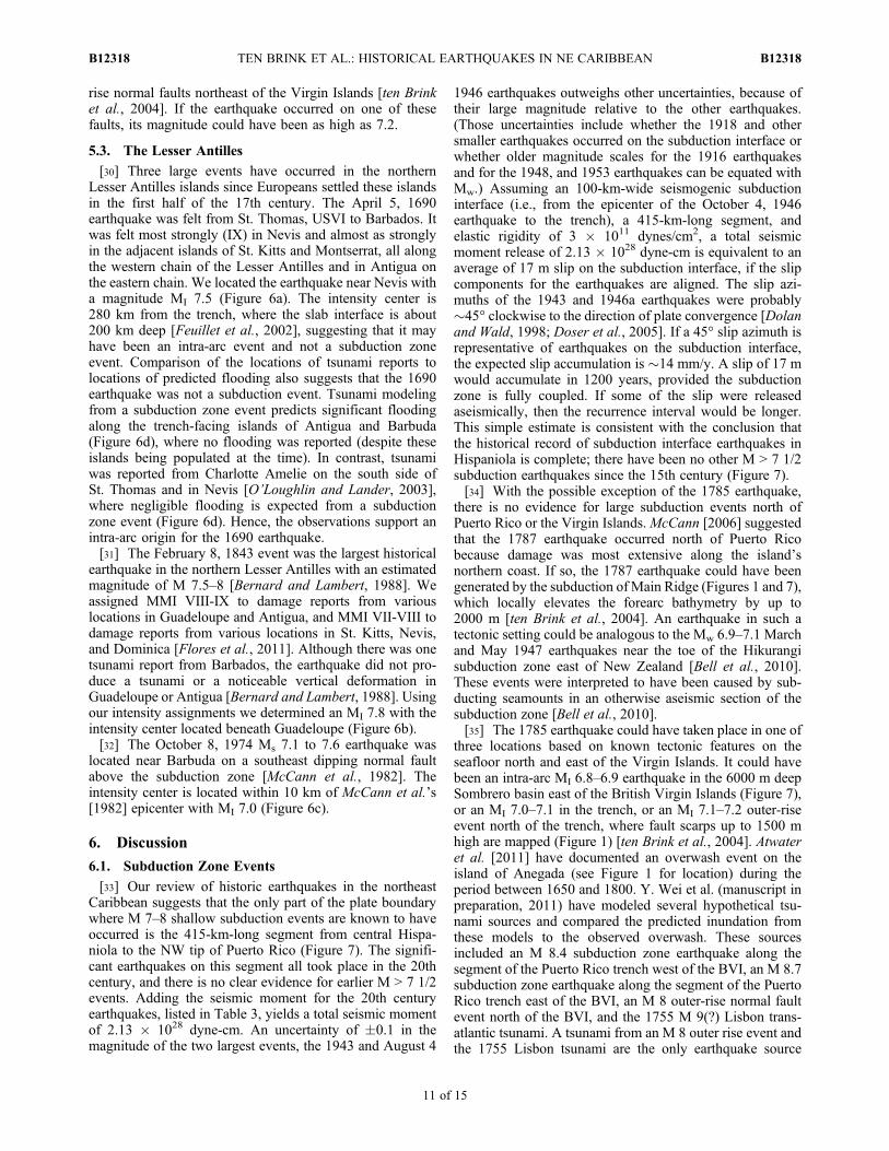
[33] Our review of historic earthquakes in the northeastCaribbean suggests that the only part of the plate boundarywhere M 7–8 shallow subduction events are known to haveoccurred is the 415-km-long segment from central Hispa-niola to the NW tip of Puerto Rico (Figure 7). The signifi-cant earthquakes on this segment all took place in the 20thcentury, and there is no clear evidence for earlier M > 7 1/2events. Adding the seismic moment for the 20th centuryearthquakes, listed in Table 3, yields a total seismic momentof 2.13 � 1028 dyne-cm. An uncertainty of �0.1 in themagnitude of the two largest events, the 1943 and August 4
1946 earthquakes outweighs other uncertainties, because oftheir large magnitude relative to the other earthquakes.(Those uncertainties include whether the 1918 and othersmaller earthquakes occurred on the subduction interface orwhether older magnitude scales for the 1916 earthquakesand for the 1948, and 1953 earthquakes can be equated withMw.) Assuming an 100-km-wide seismogenic subductioninterface (i.e., from the epicenter of the October 4, 1946earthquake to the trench), a 415-km-long segment, andelastic rigidity of 3 � 1011 dynes/cm2, a total seismicmoment release of 2.13 � 1028 dyne-cm is equivalent to anaverage of 17 m slip on the subduction interface, if the slipcomponents for the earthquakes are aligned. The slip azi-muths of the 1943 and 1946a earthquakes were probably�45° clockwise to the direction of plate convergence [Dolanand Wald, 1998; Doser et al., 2005]. If a 45° slip azimuth isrepresentative of earthquakes on the subduction interface,the expected slip accumulation is �14 mm/y. A slip of 17 mwould accumulate in 1200 years, provided the subductionzone is fully coupled. If some of the slip were releasedaseismically, then the recurrence interval would be longer.This simple estimate is consistent with the conclusion thatthe historical record of subduction interface earthquakes inHispaniola is complete; there have been no other M > 7 1/2subduction earthquakes since the 15th century (Figure 7).[34] With the possible exception of the 1785 earthquake,
there is no evidence for large subduction events north ofPuerto Rico or the Virgin Islands.McCann [2006] suggestedthat the 1787 earthquake occurred north of Puerto Ricobecause damage was most extensive along the island’snorthern coast. If so, the 1787 earthquake could have beengenerated by the subduction of Main Ridge (Figures 1 and 7),which locally elevates the forearc bathymetry by up to2000 m [ten Brink et al., 2004]. An earthquake in such atectonic setting could be analogous to the Mw 6.9–7.1 Marchand May 1947 earthquakes near the toe of the Hikurangisubduction zone east of New Zealand [Bell et al., 2010].These events were interpreted to have been caused by sub-ducting seamounts in an otherwise aseismic section of thesubduction zone [Bell et al., 2010].[35] The 1785 earthquake could have taken place in one of
three locations based on known tectonic features on theseafloor north and east of the Virgin Islands. It could havebeen an intra-arc MI 6.8–6.9 earthquake in the 6000 m deepSombrero basin east of the British Virgin Islands (Figure 7),or an MI 7.0–7.1 in the trench, or an MI 7.1–7.2 outer-riseevent north of the trench, where fault scarps up to 1500 mhigh are mapped (Figure 1) [ten Brink et al., 2004]. Atwateret al. [2011] have documented an overwash event on theisland of Anegada (see Figure 1 for location) during theperiod between 1650 and 1800. Y. Wei et al. (manuscript inpreparation, 2011) have modeled several hypothetical tsu-nami sources and compared the predicted inundation fromthese models to the observed overwash. These sourcesincluded an M 8.4 subduction zone earthquake along thesegment of the Puerto Rico trench west of the BVI, an M 8.7subduction zone earthquake along the segment of the PuertoRico trench east of the BVI, an M 8 outer-rise normal faultevent north of the BVI, and the 1755 M 9(?) Lisbon trans-atlantic tsunami. A tsunami from an M 8 outer rise event andthe 1755 Lisbon tsunami are the only earthquake source
TEN BRINK ET AL.: HISTORICAL EARTHQUAKES IN NE CARIBBEAN B12318B12318
11 of 15
models capable of overtopping the offshore reef and theonshore beach ridge and flooding the island of Anegada. Themagnitude of the 1785 earthquake is too small to generatea tsunami, unless it was a slow “tsunami earthquake”[Kanamori, 1972], that generated relatively little shaking atfrequencies that affect people and man-made structures. TheLisbon tsunami is known to have caused damaging tsunamiin the Lesser Antilles and Brazil [e.g., Barkan et al., 2009]and is the likely source of the Anegada island overwashevent.[36] In the Lesser Antilles, the three significant historical
events appear to be intra-arc earthquakes, although the 1843earthquake could have been a subduction event. The depthto the slab interface beneath our preferred location inGuadeloupe is 125 km [Feuillet et al., 2002]. However, ifthe earthquake was located east of Barbuda (see bootstraplocation in Figure 6b) where the depth to the slab is only30 km [Feuillet et al., 2002], then the earthquake couldhave been an MI 8.2 subduction earthquake. Instrumentallyrecorded earthquakes in the Lesser Antilles between 1950and 1978 [Stein et al., 1982, 1983] and later earthquakes in1985, 1992, 2001 [Feuillet et al., 2002] had mainly strike-slip or normal fault mechanisms and were located within thearc. Stein et al. [1982, 1983] suggested that the plateboundary is largely decoupled and that the downgoing slabis in extension.[37] Geist and Parsons [2009] estimated the recurrence
interval for M 7.5 events along the entire Hispaniola-PuertoRico-Lesser Antilles subduction zone to be 67–125 years,provided the subduction zone is fully coupled. The lowfrequency of M > 7.5 earthquakes in the historical recordsuggests, that with the exception of the segment north ofHispaniola, seismic coupling is low.
6.2. Recurrence Intervals on the Septentrional Fault
[38] Inferences about rupture modes and recurrence inter-vals of the Septentrional fault system depend not just on theinterpretation of the 1562 and 1842 earthquakes but also onthe earthquake histories inferred from trenches along theSeptentrional fault (Figure 1). At one trench site, the mostrecent rupture dates to AD 1040–1230 and shows a mini-mum of 4 m of left-lateral motion and 2.3 m of normal slip[Prentice et al., 2003]. Horizon folding at a second siteoccurred sometimes after 3900 BP and before AD 1440–1640 and was ascribed by Prentice et al. [2003] to that sameevent. Their other two sites did not show evidence for AD1040–1230 faulting. Prentice et al. [2003] inferred a pen-ultimate event occurring before AD 30–240 at one site,although samples as young as AD 1680–1940 were datedadjacent to the sample of older date within the faulted sur-face deposits [Prentice et al., 2003, Figure 10]. Prenticeet al. [2003] concluded from these inferred histories arecurrence interval in the range 800–1200 years on thatsegment of the Septentrional fault. Here we propose that the1562 and 1842 earthquakes both ruptured the centralDominican Republic section of the Septentrional fault, andthat the 1842 rupture extended to the west along the northernHaiti coast. Rather than 800–1200 years, the recurrenceinterval on the central Dominican Republic section of theSeptentrional fault is about 300 years (Figure 7).[39] Prentice et al. [2003] did not interpret evidence of the
nearby 1562 earthquake (Figure 3a) in any of their trenches.Perhaps it occurred on the subduction interface, or on a sec-ondary thrust feature, as did the 2010 Haiti earthquakes [e.g.,Calais et al., 2010]. Hengesh et al. [2000], however, foundstratigraphic evidence of the 1562 earthquake in their trenchacross the Septentrional fault at old Santiago de los Caballeros,
Figure 7. Locations of intensity centers from our analysis in this paper and in the work by Bakun et al.[2011] and modern epicenters of moderate and large earthquakes between Hispaniola and Guadeloupe.Our evaluation of recurrence intervals for different tectonic regions, discussed in the text, is marked byred lines. Those parts of the subduction zone not aligned by red are not expected from this study to gen-erate large earthquakes.
TEN BRINK ET AL.: HISTORICAL EARTHQUAKES IN NE CARIBBEAN B12318B12318
12 of 15
the town destroyed by that earthquake. We assign the 1562earthquake to the Septentrional fault because of the extensivedamage and large intensity magnitude. The earthquake is notconstrained well enough to exclude the possibility that itoccurred on a thrust fault in Cordillera Septentrional, themountain range separating the fault from the northern coast.[40] The apparent absence of the 1842 earthquake in the
trench records could be explained by an earthquake sourcefarther west along the northern Haiti coast [e.g., Calais et al.,2010]. However, given the broad extent of severe damagefrom the 1842 earthquake (intensity IX in Mole St. Nicolasand in Santiago which are 290 km apart), the extent of the feltaftershocks from Mayaguez, Puerto Rico to Port-au-Prince,Haiti [Flores et al., 2011], and the size of the earthquake(MI 7.6–7.7), the earthquake is most simply explained bystrike-slip motion on a fault plane with relatively shortdowndip width. Global empirical relationships [Wesnousky,2008] show an average rupture length of 220–290 km foran Mw 7.6–7.7. The only known strike-slip fault in northernHispaniola long enough to support anMw 7.6–7.7 earthquakeis the Septentrional fault.[41] Given the broad geographical extent of severe dam-
age (Figure 3b), the magnitude of the 1842 earthquakewould have had to be much larger than MI 7.6, if it were athrust event on the subduction interface. It is possible thatthe earthquake ruptured the segment of northern Haiti,propagated smoothly through western Cibao valley, andruptured the central Dominican Republic. This rupture sce-nario would give rise to two centers of maximum momentrelease, as seen in our analysis (Figure 3b). An eyewitness inPuerto Plata described “A second shock followed, yetstronger than the former, accompanied by the same appear-ances, effects and terrors” (The Public Ledger, July 15,1842, printed letter dated May 20, 1842).[42] Locating the 1562 and 1842 earthquakes on the Sep-
tentrional fault simplifies the interpretation of the fault sliprates. The estimated Holocene rate is between 6 and 12 mm/y[Prentice et al., 2003], and the estimated present slipaccumulation rate from kinematic models that fit GPSmeasurements in Hispaniola is 12.3 mm/y [Calais et al.,2010]. If the last earthquake occurred between 1040 and1230 AD [Prentice et al., 2003], then the average slipaccumulation on the Septentrional fault to date is between4.7–11.9 m (780 yr � 6 mm/y and 970 yr � 12.3 mm/y), anunusually large amount of accumulated slip for a moder-ately long strike-slip fault. For comparison, a globalempirical relationship for strike-slip faults show an averageslip of 3.0 m for a 221 km long rupture (the equivalent ofMw 7.6), 3.4 m for a Mw 7.7 source [Wesnousky, 2008]. Thelargest documented average slip for a strike-slip source is4.7 m for the 1857 San Andreas earthquake [Wesnousky,2008]. If the 1562 and 1842 earthquakes were strike-slipearthquakes on the Septentrional fault, then the recurrenceinterval is �300 yr and the average slip accumulationbetween earthquakes would be 1.8–3.7 m (6–12.3 mm/y),more consistent with the slip reported for other M 7.5–8strike-slip earthquakes [Wesnousky, 2008].[43] Static stress models predict that the 1943–1953 sub-
duction earthquakes increased the Coulomb stress on parts ofthe Septentrional fault [Dolan and Bowman, 2004; ten Brinkand Lin, 2004] bringing it closer to failure. The absence of
subsequent rupture on the Septentrional fault is more under-standable if the last earthquake on the fault occurred in 1842rather than 800 years ago. That is, if the 1842 event occurredon the fault, then the 1943–1953 earthquakes took place earlyin a �300-year-long loading cycle of the fault. The absenceof rupture on the Septentrional fault is difficult to understandif the last earthquake on the fault occurred 780–970 yearsago, because of the 4.7–11.9 m of accumulated slip [Dolanand Bowman, 2004].
6.3. Muertos Trough
[44] Southward thrusting of eastern Hispaniola and west-ern Puerto Rico over the Caribbean plate has produced theMuertos thrust belt and Muertos Trough [Granja Bruñaet al., 2009; Ladd and Watkins, 1978] The compressiondirection appears to be perpendicular to Muertos Trough [tenBrink et al., 2009]. Byrne et al. [1985] attributed the thrustingto northward subduction of the Caribbean plate beneath theeastern Greater Antilles, based on the analysis of an Ms 6.71984 earthquake. That earthquake took place at a depth of32 km on a gently northward-dipping fault south of theDominican Republic. Byrne et al. [1985] further suggestedthat the October 18, 1751 event was an M � 8 subductionearthquake, but the weight of the evidence suggests anon-land location near Azua [Bakun et al., 2011].[45] Other recent earthquakes beneath the Muertos thrust
belt, the mb 5.6–5.8 May 2, 1968, the mb 6.1 June 11, 1971,theMs 6.7March 23, 1979, and theMs 6.1 November 5, 1979[Engdahl and Villaseñor, 2002], were deep (59–106 km),and were perhaps located on the downgoing North Americanslab. The MI 6.5–7.5 earthquakes in 1615, 1665, 1673, 1684,and 1691 (Table 2) appear to have occurred near the southcoast of the Dominican Republic, although the number ofdamage reports is too small to locate them. It is possible thatthese events were either intermediate-depth subductionearthquakes under the south coast of the Dominican Repub-lic, or onshore blind thrust-fault earthquakes, or thrust eventsfrom the Muertos trough.[46] Ten Brink et al. [2009] have argued that the Muertos
thrust belt is being formed by the transfer of compressivestresses from the Hispaniola-Puerto Rico subduction zoneacross the rigid arc to the backarc. They highlighted similartectonic regimes, where compressive stresses are transferredfrom the subduction to the back arc region, such as north ofFlores and Wetar arc in Indonesia, east of Vanuatu, andnorth of Panama and western Costa Rica. All 3 regions haveexperienced M 7.5–7.9 earthquakes within the past 20 yearsand in two of the regions these earthquakes were accompa-nied by devastating tsunamis. Thus, the occurrence of a largerelatively shallow thrust earthquake in the Muertos Troughshould not be discounted in hazard assessments.
7. Conclusions
[47] The historical record of the northeast Caribbeanislands offers a unique opportunity to study the long-termseismic activity of a plate boundary, because of the avail-ability of more than 500 years of written records that includedamage reports from earthquakes. We assigned intensities tothese damage reports, and estimated the location and mag-nitude of large historical earthquakes. Our analysis leads tothe following conclusions:
TEN BRINK ET AL.: HISTORICAL EARTHQUAKES IN NE CARIBBEAN B12318B12318
13 of 15
[48] 1. The North American subduction zone in the NECaribbean extends from central Hispaniola in the west toGuadeloupe, Lesser Antilles, in the east, a distance of1300 km. However, historical earthquakes activity on thesubduction interface can be assigned only to the 415 km–long segment from central Hispaniola to the northwest tipof Puerto Rico. A series of large earthquakes in the 20thcentury appear to have released perhaps 1200 years ofoblique slip accumulation in this segment. Earlier historicalearthquakes could not be attributed to this subductionsegment.[49] 2. The historical record is inconclusive as to the
possibility of large deep (>70 km) earthquakes under His-paniola in the 17th century, and instrumental magnitudes ofdeep earthquakes under Hispaniola are less than MI 6.7.[50] 3. We did not identify any large subduction zone
earthquakes along the Puerto Rico - Virgin Islands segment.The May 2, 1787 earthquake is smaller than previouslysuggested and was perhaps generated by the subduction ofthe “aseismic” Main ridge.[51] 4. The July 11, 1785 earthquake is poorly located and
had a magnitude range of MI 6.9–7.2, depending on itslocation, whether within the arc east or north of the BritishVirgin Islands, or near the trench, or in the outer rise.[52] 5. We did not identify large subduction earthquakes
along the Lesser Antilles. Therefore, either a large slip def-icit has accumulated in the past 500 years along the sub-duction zone from Puerto Rico to Guadeloupe, or thesubduction interface, with the exception of subducting sea-mounts, is largely decoupled and aseismic.[53] 6. Intra-arc earthquakes constitute the primary earth-
quake and tsunami hazards to the NE Caribbean. We esti-mate a �300 year recurrence interval and magnitudes ≤7.7for earthquakes on the Septentrional fault in northernHispaniola, comparable to the �300 year recurrence intervalfor the Enriquillo fault in southern Hispaniola proposed byBakun et al. [2011]. If the Septentrional fault last ruptured in1842, a large earthquake may not be as imminent, asPrentice et al. [2003] have concluded.[54] 7. Four or five MI 7.1–7.8 intra-arc earthquakes (in
1690, 1843, 1867, and 1974, and perhaps the July 11, 1785)have occurred in the past �380 years along the 420-km longarc segment between the Virgin Islands and Guadeloupe.[55] 8. Intra-arc seismic activity in Puerto Rico appears
minor. The only large strike-slip fault system, the Buncefault, is located 15–20 km south of the trench and far fromthe island.[56] 9. Earthquake intensity appears to decay more slowly
with distance in Puerto Rico and the Virgin Islands than inHispaniola and the Lesser Antilles.[57] 10. Although large earthquakes are not documented
in the Muertos thrust belt south of the Dominican Republicand Puerto Rico, the tectonic setting of this thrust belt issimilar to other backarc thrust belts where large destructiveearthquakes and tsunamis have occurred in the past 20 years.
[58] Acknowledgments. Bill Ellsworth and Ross Stein encouraged thiscollaborative effort following the 2010 Haiti earthquake and provided valu-able comments and support throughout. We thank Colleen Hurter fromMBL/WHOI Library for her help in finding historical references, BrianAtwater and Kathleen Deagan for helpful discussion, and Yong Wei for gen-erously allowing us to publish his tsunami model. Daniel Brothers and BillDillon provided helpful critical comments on the manuscript. The thoughtful
reviews by Jim Hengesh, Gordon Seitz, and Franco Pettenati are gratefullyacknowledged.
ReferencesAbe, K. (1994), Instrumental magnitudes of historical earthquakes, 1892 to1898, Bull. Seismol. Soc. Am., 84, 415–425.
Agamennone, G. (1898), Il Terremoto di Haiti (Antille) nella mattina del29 dicembre 1897, Boll. Soc. Sismol. Ital., 4, 177–191.
Ardouin, B. (1860), Études sur l’histoire d’Haïti; suivies de la vie du gén-éral J.-M. Borgella, vol. 11, 362 pp., Dézobry et E. Magdeleine, Paris.
Atwater, B. F., U. S. ten Brink, M. Buckley, R. S. Halley, B. E. Jaffe, A. M.López-Venagas, E. G. Reinhardt, M. P. Tuttle, S.Watt, and Y.Wei (2011),Geomorphic and stratigraphic evidence for an unusual tsunami or storm afew centuries ago at Anegada, British Virgin Islands, Nat. Hazards,doi:10.1007/s11069-010-9622-6, in press.
Bakun, W. H. (1999), Seismic activity in the San Francisco Bay region,Bull. Seismol. Soc. Am., 89, 764–784.
Bakun, W. H. (2006), Estimating locations and magnitudes of earthquakesin southern California from modified Mercalli intensities, Bull. Seismol.Soc. Am., 96, 1278–1295, doi:10.1785/0120050205.
Bakun, W. H., and M. G. Hopper (2004), Historical seismic activity in thecentral United States, Seismol. Res. Lett., 75(5), 564–574, doi:10.1785/gssrl.75.5.564.
Bakun, W. H., and C. M. Wentworth (1997), Estimating earthquake loca-tion and magnitude from seismic intensity data, Bull. Seismol. Soc. Am.,89, 1502–1521.
Bakun, W. H., and C. M. Wentworth (1999), Erratum to estimating earth-quake location and magnitude from seismic intensity data, Bull. Seismol.Soc. Am., 89, 557.
Bakun, W. H., C. H. Flores, and U. S. ten Brink (2011), Significant earth-quakes on the Enriquillo fault system, Hispaniola, 1500–2010: Implica-tions for seismic hazard, Bull. Seismol. Soc. Am., in press.
Barkan, R., and U. S. ten Brink (2010), Tsunami simulations of the 1867Virgin Islands earthquake: Constraints on epicenter location and faultparameters, Bull. Seismol. Soc. Am., 100, 995–1009, doi:10.1785/0120090211.
Barkan, R., U. ten Brink, and J. Lin (2009), Far field tsunami simulations ofthe 1755 Lisbon earthquake: Implications for tsunami hazard to the U.S.East Coast and the Caribbean, Mar. Geol., 264, 109–122, doi:10.1016/j.margeo.2008.10.010.
Bell, R., R. Sutherland, D. H. N. Barker, S. Henrys, S. Bannister, L. Wallace,and J. Beavan (2010), Seismic reflection character of the Hikurangi sub-duction interface, New Zealand, in the region of repeated Gisborne slowslip events, Geophys. J. Int., 180, 34–48, doi:10.1111/j.1365-246X.2009.04401.x.
Bernard, P., and J. Lambert (1988), Subduction and seismic hazard in thenorthern Lesser Antilles: Revision of the historical seismicity, Bull. Seis-mol. Soc. Am., 78(6), 1965.
Bodle, R. R., and L. M. Murphy (1984), United States earthquakes, 1946,U.S. Geol. Surv. Open File Rep., 84–941, 52 pp.
Byrne, D. E., G. Suarez, and W. R. McCann (1985), Muertos Trough sub-duction—Microplate tectonics in the northern Caribbean?, Nature, 317,420–421, doi:10.1038/317420a0.
Calais, E., and B. Mercier de Lepinay (1995), Strike-slip tectonic processesin the northern Caribbean between Cuba and Hispaniola (WindwardPassage), Mar. Geophys. Res., 17, 63–95, doi:10.1007/BF01268051.
Calais, E., et al. (2010), Transpressional rupture of an unmapped faultduring the 2010 Haiti earthquake, Nat. Geosci., 3, 794–799, doi:10.1038/ngeo992.
Charlevoix, P.-F.-X. d. (1731),Histoire de l’isle Espagnole ou de S. Domingue,Tome 1 and 2, Jacques Guerin, Paris.
Coffman, J. L., and C. W. Stover (1984), United States earthquakes, 1975,U.S. Geol. Surv. Open File Rep., 84–0975, 139 pp.
Coffman, G. L., and C. A. von Hake (1984a), United States earthquakes,1970, U.S. Geol. Surv. Open File Rep., 84–0970, 85 pp.
Coffman, J. L., and C. A. von Hake (1984b), United States earthquakes,1971, U.S. Geol. Surv. Open File Rep., 84–0971, 176 pp.
Coffman, J. L., and C. A. von Hake (1984c), United States earthquakes,1972, U.S. Geol. Surv. Open File Rep., 84–0972, 124 pp.
del Monte y Tejada, A. (1890), Historia de Santo Domingo, Tomo 1,2,3 and4, Imprenta de Garcia Hermanos, Santo Domingo, Republica Dominicana.
de Utrera, F. C. (1995), Santo Domingo: Dilucidaciones históricas, I–II,1st ed., 1191 pp., Secr. de Estado de Educ. Bellas Artes y Cultos, SantoDomingo, Dominican Republic.
Dillon, W. P., N. T. Edgar, K. M. Scanlon, and D. F. Coleman (1996), Areview of the tectonic problems of the strike-slip northern boundary ofthe Caribbean Plate and examination by GLORIA, in Geology of theUnited States’ Seafloor: The View FromGLORIA, edited by J. V. Gardneret al., pp. 135–164, Cambridge Univ. Press, Cambridge, U. K.
TEN BRINK ET AL.: HISTORICAL EARTHQUAKES IN NE CARIBBEAN B12318B12318
14 of 15
Dolan, J. F., and D. D. Bowman (2004), Tectonic and seismologic setting ofthe 22 September 2003, Puerto Plata, Dominican Republic earthquake:Implications for earthquake hazard in northern Hispaniola, Seismol.Res. Lett., 75(5), 587–597, doi:10.1785/gssrl.75.5.587.
Dolan, J. F., and D. J. Wald (1998), The 1943–1953 north-central Carib-bean earthquakes: Active tectonic setting, seismic hazards, and implica-tions for Caribbean-North America plate motions, Spec. Pap. Geol. Soc.Am., 326, 143–170.
Dookan, I. (1994), A History of the Virgin Islands of the United States,305 pp., Canoc, Kingston.
Doser, D. I., C. M. Rodriguez, and C. Flores (2005), Historical earthquakesof the Puerto Rico-Virgin Islands region; 1915–1963, Spec. Pap. Geol.Soc. Am., 385, 103–114.
Efron, B. (1982), The Jackknife, the Bootstrap and Other ResamplingPlans, Soc. for Ind. and Appl. Math., Philadelphia, Pa.
Engdahl, E. R., and A. Villaseñor (2002), Global seismicity: 1900–1999,Int. Geophys., 81, 665–690, doi:10.1016/S0074-6142(02)80244-3.
Feuillet, N., I. Manighetti, P. Tapponnier, and E. Jacques (2002), Arc parallelextension and localization of volcanic complexes in Guadeloupe, LesserAntilles, J. Geophys. Res., 107(B12), 2331, doi:10.1029/2001JB000308.
Flores, C. H., U. S. ten Brink, and W. H. Bakun (2011), Accounts of dam-age from historical earthquakes in the northeastern Caribbean, to aid inthe determination of their location and intensity magnitudes, U.S. Geol.Surv. Open File Rep., 2011–1133, 226 pp.
García, J. G. (1900), Compendio de la Historia de Santo Domingo,Imprenta de García Hermanos, Santo Domingo, Dominican Republic.
Geist, E. L., and T. Parsons (2009), Assessment of source probabilities forpotential tsunamis affecting the U.S. Atlantic coast, Mar. Geol., 264,98–108, doi:10.1016/j.margeo.2008.08.005.
Granja Bruña, J. S., U. S. ten Brink, A. Carbó-Gorosabel, A. Muñoz-Martín,andM. Gómez Ballesteros (2009), Morphotectonics of the central Muertosthrust belt and Muertos Trough (northeast Caribbean), Mar. Geol., 263,7–33, doi:10.1016/j.margeo.2009.03.010.
Gutenberg, B., and C. F. Richter (1954), Seismicity of the Earth and Asso-ciated Phenomena, Princeton Univ. Press, Princeton, N. J.
Hall, M. (1922), Earthquakes in Jamaica, From 1688 to 1919: With Map,edited by Jamaica Meteorol. Serv., Govt. Print. Off., Kingston.
Hengesh, J. V., L. R. Peña, and J. Bachhuber (2000), Possible geologicalevidence for surface fault rupture related to the 1562 Santiago Viejoearthquake, Dominican Republic, Eos Trans. AGU, 81(48), Fall Meet.Suppl., Abstract T11B-03.
Kanamori, H. (1972), Mechanism of tsunami earthquakes, Phys. EarthPlanet. Inter., 6, 346–359, doi:10.1016/0031-9201(72)90058-1.
Kelleher, J., L. Sykes, and J. Oliver (1973), Possible criteria for predictingearthquake locations and their application to major plate boundaries of thePacific and the Caribbean, J. Geophys. Res., 78, 2547–2585, doi:10.1029/JB078i014p02547.
Ladd, J. W., and J. S. Watkins (1978), Active margin structures within thenorth slope of the Muertos Trench, Geol. Mijnbouw, 57, 255–260.
Le Gaulois (1887), Province et Etranger: Madrid, 27 Sept.Lynch, J. J., and R. R. Bodle (1948), The Dominican earthquakes ofAugust, 1946, Bull. Seismol. Soc. Am., 38, 1–17.
Mann, P., C. S. Prentice, G. S. Burr, L. R. Pena, and F. W. Taylor (1998),Tectonic geomorphology and paleoseismology of the Septentrional faultsystem, Dominican Republic, Spec. Pap. Geol. Soc. Am., 326, 63–123.
Mann, P., E. Calais, J.-C. Ruegg, C. DeMets, P. E. Jansma, and G. S. Mattioli(2002), Oblique collision in the northeastern Caribbean fromGPS measure-ments and geological observations, Tectonics, 21(6), 1057, doi:10.1029/2001TC001304.
McCann, W. R. (1985), On the earthquake hazards of Puerto Rico and theVirgin Islands, Bull. Seismol. Soc. Am., 75, 251–262.
McCann, W. R. (2006), Estimating the threat of tsunamigenic earthquakesand earthquake induced-landslide tsunamis in the Caribbean, in Carib-bean Tsunami Hazard, edited by A. Mercado and P. Liu, pp. 43–65,World Sci., Singapore.
McCann, W. R., J. W. Dewey, A. J. Murphy, and S. T. Harding (1982), Alarge normal-fault earthquake in the overriding wedge of the Lesser Antil-les subduction zone: The earthquake of 8 October 1974, Bull. Seismol.Soc. Am., 72(6A), 2267–2283.
McCann, W. R., L. Feldman, and M. McCann (2011), Catalog of felt earth-quakes for Puerto Rico and neighboring islands 1492–1899 with additionalinformation for some 20th century earthquakes, Rev. Geofís. Num. 62,141–293.
Mercator, G. (1628), Zeilan Insula, Jan Jansson, Antwerp, Belgium.Moreau de Saint-Méry, L.-É. (1796), Description Topographique etPolitique de la Partie Espagnole de l’isle Saint-Domingue, 311 pp.,Philadelphia, Pa.
Morison, S. E. (1942), Admiral of the Ocean Sea: A Life of ChristopherColumbus, 680 pp., Little, Brown, and Co., Boston, Mass.
Motazedian, D., and G. Atkinson (2005), Ground-motion relations forPuerto Rico, in Active Tectonics and Seismic Hazards of Puerto Rico,the Virgin Islands, and Offshore Areas, edited by P. Mann, Spec Pap.Geol. Soc. Am., 385, 61–80, doi:10.1130/0-8137-2385-X.61.
O’Loughlin, K. F., and J. F. Lander (2003), Caribbean Tsunamis: A 500-YearHistory From 1498–1998, Kluwer Acad., Dordrecht, Netherlands.
Ortelius, A. (1579),Culiacanae, Americae regionis, descriptio. Hispaniolae,Cubae, aliarumque insularum circumiacientium, delineatio, AbrahamOrtelius, Antwerp, Belgium.
Perrey, A. (1857), Note sur les Tremblements de Terre ressentis en 1855,avec supplements pour les annees anterieures, Bull. Acad. R. Sci. Lett.Beaux Arts Belg., 1(2), 64–109.
Poey, A. (1857), Catalogue chronologique des tremblements de terreressentis dans les Indes-Occidentales, de 1530 a 1857, Annu. Soc.Meteorol. Fr., 5, 75–127.
Prentice, C. S., P. Mann, L. R. Pena, and G. Burr (2003), Slip rate and earth-quake recurrence along the central Septentrional Fault, North American-Caribbean plate boundary, Dominican Republic, J. Geophys. Res., 108(B3),2149, doi:10.1029/2001JB000442.
Reid, H. F., and S. Taber (1920), The Virgin Island earthquakes of1867–1868, Bull. Seismol. Soc. Am., 10, 9–30.
Scherer, J. (1912), Great earthquakes in the island of Haiti, Bull. Seismol.Soc. Am., 2, 161–180.
Shaler, N. S. (1869), Earthquakes of the American continent, Atl. Mon., 24,461–469.
Southey, T. (1827), Chronological History of the West Indies, vols. I, 2, and3, Longman Rees Orme Brown and Green, London.
Stein, S., J. F. Engeln, D. A. Wiens, K. Fujita, and R. C. Speed (1982), Sub-duction seismicity and tectonics in the Lesser Antilles Arc, J. Geophys.Res., 87, 8642–8664, doi:10.1029/JB087iB10p08642.
Stein, S., J. F. Engeln, D. A. Wiens, R. C. Speed, and K. Fujita (1983),Slow subduction of old lithosphere in the Lesser Antilles, Tectonophy-sics, 99(2–4), 139–148, doi:10.1016/0040-1951(83)90099-9.
Stover, C. W., and L. R. Brewer (1991), United States earthquakes, 1985,U.S. Geol. Surv. Bull., 1954, 170 pp.
ten Brink, U. S. (2005), Vertical motions of the Puerto Rico Trench and PuertoRico and their cause, J. Geophys. Res., 110, B06404, doi:10.1029/2004JB003459.
ten Brink, U. S., and J. Lin (2004), Stress interaction between subductionearthquakes and forearc strike-slip faults: Modeling and application tothe northern Caribbean plate boundary, J. Geophys. Res., 109, B12310,doi:10.1029/2004JB003031.
ten Brink, U. S., W. W. Danforth, C. Polloni, B. Andrews, P. Llanes, S. V.Smith, E. Parker, and T. Uozumi (2004), New sea floor map of the PuertoRico trench helps assess earthquake and tsunami hazards, Eos Trans.AGU, 85(37), 349.
ten Brink, U. S., S. Marshak, and J. L. Granja-Bruna (2009), Bivergentthrust wedges surrounding oceanic island arcs: Insight from observationsand sandbox models of the northeastern Caribbean plate, Geol. Soc. Am.Bull., 121, 1522–1536, doi:10.1130/B26512.1.
The New York Times (1887), Shaken by an earthquake, 11 Oct.The New York Times (1898), Santo Domingo earthquakes, Some details ofthe damage inflicted upon the island, 20 Jan.
Tippenhauer, L. G. (1893), Liste der Erdbeben auf Haiti, in Die Insel Haiti,pp. 170–175, F. A. Brockhaus, Leipzig, Germany.
Tomblin, J. M., and G. R. Robson (1977), A Catalogue of Felt Earthquakesfor Jamaica, With References to Other Islands in the Greater Antilles,1564–1971, Minist. of Min. and Nat. Resour., Kingston.
Wesnousky, S. G. (2008), Displacement and geometrical characteristics ofearthquake surface ruptures: Issues and implications for seismic-hazardanalysis and the process of earthquake rupture, Bull. Seismol. Soc. Am.,98, 1609–1632, doi:10.1785/0120070111.
W. H. Bakun, U.S. Geological Survey, Menlo Park, CA 94025, USA.C. H. Flores and U. S. ten Brink, U.S. Geological Survey, Woods Hole,
MA 02543, USA. ([email protected])
TEN BRINK ET AL.: HISTORICAL EARTHQUAKES IN NE CARIBBEAN B12318B12318
15 of 15