spatial interpolation comparison - evaluation of spatial...
TRANSCRIPT

Spatial Interpolation ComparisonEvaluation of spatial prediction methods
Tomislav Hengl
ISRIC — World Soil Information, Wageningen University
Geostatistics course, 25–29 October 2010, Wageningen

Topic
I Geostatistics = a toolbox to generate maps from point datai.e.to interpolate;
I There are many possibilities;
I An inexperienced user will often be challenged by the amountof techniques to run spatial interpolation;
I . . .which method should we use?
Geostatistics course, 25–29 October 2010, Wageningen

Have you heard of SIC?
Geostatistics course, 25–29 October 2010, Wageningen

The spatial prediction game
Participants were invited to estimate values located at 1000locations (right, crosses), using 200 observations (left, circles).
Geostatistics course, 25–29 October 2010, Wageningen

Lessons learned (from SIC)
Geostatistics course, 25–29 October 2010, Wageningen

Li and Heap (2008)
Geostatistics course, 25–29 October 2010, Wageningen

How many techniques are there?
Li and Heap (2008) list over 40 unique techniques.
1. Are all these equally valid?
2. How to objectively compare various methods (which criteriato use)?
3. Which method to pick for your own case study?
Geostatistics course, 25–29 October 2010, Wageningen

There are not as many
There are roughly four main clusters of techniques:
1. splines (deterministic);
2. kriging-based (plain geostatistics);
3. regression-based;
4. expert systems / machine learning;
Geostatistics course, 25–29 October 2010, Wageningen

There are not as many
There are roughly four main clusters of techniques:
1. splines (deterministic);
2. kriging-based (plain geostatistics);
3. regression-based;
4. expert systems / machine learning;
Geostatistics course, 25–29 October 2010, Wageningen

There are not as many
There are roughly four main clusters of techniques:
1. splines (deterministic);
2. kriging-based (plain geostatistics);
3. regression-based;
4. expert systems / machine learning;
Geostatistics course, 25–29 October 2010, Wageningen

There are not as many
There are roughly four main clusters of techniques:
1. splines (deterministic);
2. kriging-based (plain geostatistics);
3. regression-based;
4. expert systems / machine learning;
Geostatistics course, 25–29 October 2010, Wageningen

The 5 criteria
1. the overall mapping accuracy, e.g.standardized RMSE atcontrol points — the amount of variation explained by thepredictor expressed in %;
2. the bias, e.g.mean error — the accuracy of estimating thecentral population parameters;
3. the model robustness, also known as model sensitivity — inhow many situations would the algorithm completely fail /how much artifacts does it produces?;
4. the model reliability — how good is the model in estimatingthe prediction error (how accurate is the prediction varianceconsidering the true mapping accuracy)?;
5. the computational burden — the time needed to completepredictions;
Geostatistics course, 25–29 October 2010, Wageningen

Can we simplify this?
1. In theory, we could derive a single composite measure thatwould then allow you to select ‘the optimal’ predictor for anygiven data set (but this is not trivial!)
2. But how to assign weights to different criteria?
3. In many cases we simply finish using some naıve predictor —that is predictor that we know has a statistically more optimalalternative, but this alternative is not feasible.
Geostatistics course, 25–29 October 2010, Wageningen

Automated mapping
In the intamap package1 decides which method to pick for you:
> meuse$value <- log(meuse$zinc)
> output <- interpolate(data=meuse, newdata=meuse.grid)
R 2009-11-11 17:09:14 interpolating 155 observations,
3103 prediction locations
[Time models loaded...]
[1] "estimated time for copula 133.479866956255"
Checking object ... OK
1http://cran.r-project.org/web/packages/intamap/
Geostatistics course, 25–29 October 2010, Wageningen

Hypothesis
We need a single criteria to compare various prediction methods.
Geostatistics course, 25–29 October 2010, Wageningen
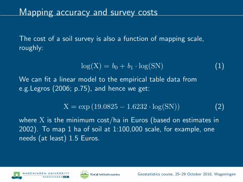
Mapping accuracy and survey costs
The cost of a soil survey is also a function of mapping scale,roughly:
log(X) = b0 + b1 · log(SN) (1)
We can fit a linear model to the empirical table data frome.g.Legros (2006; p.75), and hence we get:
X = exp (19.0825− 1.6232 · log(SN)) (2)
where X is the minimum cost/ha in Euros (based on estimates in2002). To map 1 ha of soil at 1:100,000 scale, for example, oneneeds (at least) 1.5 Euros.
Geostatistics course, 25–29 October 2010, Wageningen

Survey costs and mapping scale
●
●
●
●
●
9.5 10.0 10.5 11.0 11.5 12.0 12.5
−1
01
23
Scale number (log−scale)
Min
imum
sur
vey
cost
s in
EU
R /
ha (
log−
scal
e)
Geostatistics course, 25–29 October 2010, Wageningen

Survey costs and mapping scale
Total costs of a soil survey can be estimated by using the size ofarea and number of samples.The effective scale number (SN) is:
SN =
√4 · A
N· 102 . . . SN =
√A
N· 102 (3)
where A is the surface of the study area in m2 and N is the totalnumber of observations.
Geostatistics course, 25–29 October 2010, Wageningen

Converges to:
X = exp
(19.0825− 1.6232 · log
[0.0791 ·
√A
N· 102
])(4)
Geostatistics course, 25–29 October 2010, Wageningen

Output map, from info perspective
The resulting (predictions) map is a sum of two signals:
Z ∗(s) = Z (s) + ε(s) (5)
where Z (s) is the true variation, and ε(s) is the error component.The error component consists, in fact, of two parts: (1) theunexplained part of soil variation, and (2) the noise (measurementerror). The unexplained part of soil variation is the variation wesomehow failed to explain because we are not using all relevantcovariates and/or due to the limited sampling intensity.
Geostatistics course, 25–29 October 2010, Wageningen

Prediction accuracy
In order to see how much of the global variation budget has beenexplained by the model we can use:
RMSE r (%) =RMSE
sz· 100 (6)
where sz is the sampled variation of the target variable.RMSE r (%) is a global estimate of the map accuracy, valid onlyunder the assumption that the validation points are spatiallyindependent from the calibration points, representative and largeenough (�100).
Geostatistics course, 25–29 October 2010, Wageningen

Kriging efficiency
Geostatistics course, 25–29 October 2010, Wageningen

Prediction accuracy and survey costs
Geostatistics course, 25–29 October 2010, Wageningen

Mapping efficiency
We propose the measure of mapping efficiency, defined as theamount of money needed to map an area of standard size andexplain each one percent of variation in the target variable:
θ =X
A · RMSE r[EUR · km−2 ·%−1] (7)
where X is the total costs of a survey, A is the size of area inkm−2, and RMSE r is the amount of variation explained by thespatial prediction model.
Geostatistics course, 25–29 October 2010, Wageningen

Comparing methods
Geostatistics course, 25–29 October 2010, Wageningen
Exercise
To follow this exercise, obtain the GlobalSoilMap_calculus.R
script. Download it to your machine and then run step-by-step.
Geostatistics course, 25–29 October 2010, Wageningen

Meuse data
> data(meuse)
> coordinates(meuse) <- ~x+y
> proj4string(meuse) <- CRS("+init=epsg:28992")
> sel <- !is.na(meuse$om)
> bubble(meuse[sel,], "om")
om
●●●●●●
●●● ●●●
●●●●
●●
●●●●●
●●●●
●●
●
●●
●●●●
●●●●●
●
●●●
●●
●●
●●●●●●
●●
●●●●
●●●
●●
●●●●
●●●●●
●●●●
●
●
●
●●
●●
●● ●●
●
●●
●
●●●
● ●●
●
●
●●
●
●●
●●
●●
●●●
●
●
●●
●●●
●●
●●
●
●
●
●
●
●
●
●●
●
●●●
● ●●
●●●●
● ●
●●
●●●
●
●
●●●●
15.36.9917
Geostatistics course, 25–29 October 2010, Wageningen
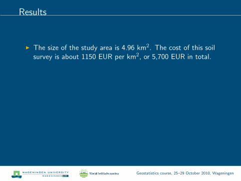
Results
I The size of the study area is 4.96 km2. The cost of this soilsurvey is about 1150 EUR per km2, or 5,700 EUR in total.
I The cross-validation error for mapping organic matter is:0.234 for OK and 0.222 for RK method (values in log-scale).
I The mapping efficiency for RK method is hence20.70 EUR km−2 %−1, compared to 22.08 EUR km−2 %−1
for the OK method.
I There is a gain of ca.7% in the mapping efficiency with theRK method compared to the OK method.
Geostatistics course, 25–29 October 2010, Wageningen

Whitening
Geostatistics course, 25–29 October 2010, Wageningen

Conclusions
I Mapping efficiency (cost / area / percent of varianceexplained) is a possible universal criteria to compare predictionmethods.
I Maps are not what they seem.
I Geostatistics really outperforms non-statistical methods (butthis is area/data dependent).
I It’s not about the making beautiful maps, it’s aboutunderstanding what they mean.
I If you deal with several equally valid (independent) methods,maybe you should consider combining them?
Geostatistics course, 25–29 October 2010, Wageningen

Literature
Dubois, G. (Ed.), 2005. Automatic mapping algorithms for routineand emergency monitoring data. Report on the Spatial InterpolationComparison (SIC2004) exercise. EUR 21595 EN. Office for OfficialPublications of the European Communities, Luxembourg, p. 150.
Hengl, T., 2009. A Practical Guide to Geostatistical Mapping, 2ndedition. University of Amsterdam, 291 p. ISBN 978-90-9024981-0.
Li, J., Heap, A., 2008. A review of spatial interpolation methods forenvironmental scientists. Record 2008/23. Geoscience Australia,Canberra, p. 137.
Pebesma, E., Cornford, D., Dubois, D., Heuvelink, G.B.M.,Hristopoulos, D., Pilz, J., Stohlker, U., Morin, G., Skoien, J.O.,2010. INTAMAP: The design and implementation of aninteroperable automated interpolation web service. Computers &Geosciences, In Press, Corrected Proof.
Geostatistics course, 25–29 October 2010, Wageningen