r i 5650 -...
TRANSCRIPT

R I bureau of mines report of investigations 5650
TUNGSTEN DEPOSITS OF COCHISE, PIMA, AND SANTA CRUZ COUNTIES, ARE.
By V. B. Dale, L. A. Stewart, and W. A. McKinney
UNITED STATES DEPARTMENT OF THE INTERIOR

TUNGSTEN DEPOSITS OF COCHISE, PIMA, AND SANTA CRUZ COUNTIES, AFUZ.
By V. B. h l e , L . A. Stewart, and W. A. MJ(inney
+ r r + r + r r r report of investigations 5650
UNITED STATES DEPARTMENT OF THE lNTERIOR Fred A. Seaton, Secretary
BUREAU OF MINES Marling J. Ankeny, Director

This publication h a s been cataloged as follows:
I Dale, Vernon B
Tungsten deposits of Cochise. P i m , and Santa Cruz coun- ties, Ariz., by V. B. Dole. L. A. Stewart, and W . A. McKinney. [Washingtonl U S . Dept. of the Interior, Bureau of Mines [I 9601
iv. 132 p. illus., mops, tobles. 26 cm. (US. %re-" of Mines. Report of investigotions. 5650)
Bibliographicd footnotes.
1 . Tungsten - Arizona. I. Title. (Series1
TN23.U7 no. 5650 622.06173
I U.S. Dept. of the Int. Library.
For sale by the Superintendent of Documents, US. Government Printing Office Washington 25, D.C. - Price 65 cents

CONTENTS
Summary and introduction ................................. Acknowledgments .......................................... Description of deposits .................................. ...................................... Cochise County
Paradise-Dos Cabezas area ...................... Silver Hill mine .......................... Galeyville group .......................... Columbia mine ............................. Leadville group ........................... Kentucky Belle and Boston Belle ........... ................... King Ainsworth property Chiricahua mine ........................... Hilltop mine .............................. Silver Strike (Devonian group) ............ Silver Bell claims ........................ ............................... Austin mine ................................ Ram claims Comstock Lode tungsten claims ............. Rough claims ..............................
Huachuca Mountains area ........................ Tungsten Reef mine ........................ Emerald claims ............................ Lucky Strike mine ......................... Jack Wakefield mine ....................... ............................... Harper mine ................................. Mori mill Van Horn property ......................... Western tungsten mine ..................... Zaleski claims ............................ ............................... Arrow group Fort Huachuca Military Reservation ........
Little Dragoon Mountains. ...................... Tungsten King mine ........................ Standard tungsten mill at Pomerene, Ariz .. Primos group .............................. Little Fanny group ........................ Boulder claims ............................ Burrell claim ............................. Homestake group ........................... Johnson Camp .............................. ................................... Placers ............................ Whetstone Mountains Chadwick claims ........................... James (Nunnelley) claims .................. Evening Star claims .......................

CONTENTS (Con . )
Dragoon Mountains .............................. ........ Black Pr ince and Johnnie Boy group Swisshelm Mountains ............................ ........... Big Four and Valley View cla ims Mineral Reserves m i l l ..........................
Pima County ......................................... Eas te rn p a r t of t h e Papago I n d i a n Reservation .. .................................. Northern a r e a
Big Banana mine ( C . G . Glasscock- T ide lands O i l CO.) ....................... ............................... Linda c la im
Sparks mine ............................... ............................ Brown prospect L a s t Chance claim ......................... ............................. San Juan mine Jezebel mine .............................. .......................... Yellow S t a r mine Independence group ........................ .......................... Rushbey prospect .................. Cable and Gajewski c la im Souths ide p rospec t ........................ ......................... C a l v e r t p rospec t s ....................... Lone Eagle prospect Mego Nos . 1 and 2 .........................
Southern a r e a .................................. .............................. Gian t c la ims ................................... Mil l ing Mineral Hill-Twin B u t t e s a r e a ..................
Sena to r Morgan mine ....................... S e r a s i o mine .............................. Mineral H i l l mine .........................
Arivaca d i s t r i c t ............................... Good Enough c la ims ........................ Vindica to r claim .......................... Las G u i j a s mine ........................... Black Gold group .......................... ........................... E a s t e r p rospec t Arivaca p l a c e r s ........................... ......................... Les j imf re prospect C i r c l e c la ims .............................
Empire Mountains ............................... H i l t o n proper ty ............................
Santa R i t a Mountains ........................... Helve t i a Camp ............................. Christenson-Lane group .................... ............................ C 8 H prospect 111

CONTENTS (Con . )
S a n t a C a t a l i n a Mountains ....................... ........................... T a y l o r X c l a i m s C o n t r o l mines ............................. Big Bug c l a ims ............................
San ta Cruz County ................................... Calabasas t u n g s t e n ............................. Martha Washington c l a i m ........................ Red Mountain c l a ims ............................
Appendix ....................................... Rock-type l o g .... Assay l o g ........................................ Mines checked w i t h u l t r a v i o l e t lamp which showed no
evidence o f s c h e e l i t e m i n e r a l i z a t i o n .............. ILLUSTRATIONS
P o t e n t i a l l y s c h e e l i t e - b e a r i n g P a l e o z o i c l imes tone a r e a i n C a l i f o r n i a mining d i s t r i c t . Cochise County. A r i z ..............................
Locat ion map of Paradise-Dos Cabezas a r e a ........... S i l v e r H i l l mine from Brunton survey ................ Geologic map o f p a r t of t h e P a r a d i s e a r e a .
Cochise County. A r i z .............................. ................. Columbia mine. Cochise County. A r i z P l a n and s e c t i o n . Devonian mine.
Cochise County. A r i z .............................. P l a n and s e c t i o n of i n c l i n e s h a f t on e p i d o t e v e i n .
Devonian p r o p e r t y . Cochise County. A r i z ........... E l l a s h a f t workings. S i l v e r B e l l claim.
Cochise County. A r i z .............................. ...... Workings on A u s t i n c la im. Cochise County. A r i z Loca t ion map. Huachuca Mountains a r e a .
Cochise County. Ar i z .............................. Flowsheet . Tungsten Reef m i l l . Huachuca Mountains ... Tungsten Reef mine. Cochise County. A r i z ............ P l a n of Harper mine from Brunton survey ............. S e c t i o n of main tunne l . Harper mine.
Cochise County. A r i z .............................. Locat ion map of L i t t l e Dragoon d e p o s i t s .
Cochise County. Ar i z .............................. Tungsten King mine. L i t t l e Dragoon Mountains ........ Primos mine. L i t t l e Dragoon Mountains ............... Sketch map of L i t t l e Fanny mine. L i t t l e Dragoon ......................................... Mountains ........ Locat ion map o f Whetstone Mountains d e p o s i t s
iii
112 112 113 118 119 119 120 122
123 130
132
4 5 7
9 1 3
1 9
2 1
23 24
28 30 32 36
37
42 44 47
49 55

ILLUSTRATIONS (Con. ) &
Loca t ions map o f Black P r i n c e and Johnn ie Boy group, Dragoon Mountains................................,
Black P r i n c e and Johnn ie Boy c l a ims , Dragoon Mountains........................................,
Big Four mine, Swisshelm Mountains.................. No. 1 a d i t , Big Four mine, Swisshelm Mountains...... Tungsten d e p o s i t s , e a s t e r n p a r t o f Papago I n d i a n
R e s e r v a t i o n , Pima County, A r i z . . . . . . . . . . . . . . . . . . . . Loca t ion map o f t u n g s t e n d e p o s i t s , n o r t h e r n
Baboquivar i Mountains area........................ P l a n and s e c t i o n , Big Banana mine................... Claim map, G i a n t t u n g s t e n group, Pima County, Ar iz . . M i l l f l owshee t , C. G. Glasscock-Tidelands O i l Co.,
Pima County, Ariz......... ........................ Loca t ion map of t u n g s t e n d e p o s i t s i n Minera l H i l l -
Twin B u t t e s a r e a , Pima County, Ariz........... .... Claim map, Morgan group............................. Q u a r t z a r e a , S e n a t o r Morgan mine (composi te ) ........ Blocks I and 11, q u a r t z a r e a , S e n a t o r Morgan mine... I Blocks I11 and I V , q u a r t z a r e a , S e n a t o r Morgan mine. Block V, q u a r t z a r e a , S e n a t o r Morgan mine........... T e s t p i t , No. 16-B, S e n a t o r Morgan mine............. Sena to r Morgan mine, Morgan ( o l d ) s h a f t ,
165-foot level.................................... P a r t o f S e r a s i o group, Twin B u t t e s d i s t r i c t ,
Pima County, Ar i z . . ............................... Loca t ion of t u n g s t e n p r o p e r t i e s i n t h e Ar ivaca a r e a ,
Pima County, A r i z . . . . . . . . . . . . . . . . . . . . . . . . . . . . . . . . . P l a n of mine workings, Good Enouqh No. 1 t u n q s t e n .
c la im, Pima County, A r i z . . . . . . . . . . . . . . . . . . . . . . . . . . . 101 Tungsten Mining Corp. t u n g s t e n p r o p e r t y , Las G u i j a s
d i s t r i c t , Pima County, A r i z . . . . . . . . . . . . . . . . . . . . . . . . 103 Locat ion map showing approximate t r e n d of s c h e e l i t e
zone, Empire Mountains, Pima County, Ariz.. . . . . . . . . 108 Loca t ion map o f s c h e e l i t e occu r rences i n H e l v e t i a
d i s t r i c t , Pima County, A r i z . . . . . . . . . . . . . . . . . . . . . . . 110 Loca t ion map of C & H prospect...................... 112 Loca t ion map of s c h e e l i t e d e p o s i t s i n San ta C a t a l i n a
Mountains, Pima County, A r i z . . . . . . . . . . . . . . . . . . . . . . 114 Geologic map o f Tay lo r X s c h e e l i t e d e p o s i t .......... 115 C o n t r o l mines, S a n t a C a t a l i n a Mountains,
Pima County, A r i z . . . . . . . . . . . . . . . . . . . . . . . . . . . . . . . . . 116 Loca t ion map o f Big Bug p rospec t , San ta C a t a l i n a
Mountains, Pima County, A r i z . . . . . . . . . . . . . . . . . . . . . . 119 Loca t ion map o f t u n g s t e n d e p o s i t s ,
S a n t a Cruz County, A r i z . . . . . . . . . . . . . . . . . . . . . . . . . . . 121

V. 8. ~ a 1 e . U L. A. Stewart,?/ and W. A. ~ c ~ i n n s ~ u
SUMMARY AND INTRODUCTION
T h i s paper i s one of a Fede ra l Bureau of Mines s e r i e s cove r ing t h e minera l r e s o u r c e s of t h e Nation. I t b r i e f l y d e s c r i b e s most of t h e t u n g s t e n d e p o s i t s i n Cochise , Pima, and Santa Cruz Coun t i e s , Ar iz . Most of t h e des- c r i p t i o n s a r e from f i e l d examinat ions by t h e two s e n i o r w r i t e r s , p r i o r t o J u l y 1957.
Wolframite f i r s t was i d e n t i f i e d i n Ar izona i n 1896 by W . P. Blake, T e r r i t o r i a l Geo log i s t . Tungsten mining began about 1900 i n t h e L i t t l e Dragoon d e p o s i t s o f Cochise County, and about 1901 i n Las G u i j a s d i s t r i c t of Pima County.
The p r i c e h i s t o r y of t ungs t en i s an e r r a t i c one; consequent ly , product ion has been e r r a t i c . P r i c e s r i s e du r ing wars and p e r i o d s of n a t i o n a l prepared- ness. P roduc t ion of t u n g s t e n o r e was s t i m u l a t e d g r e a t l y by a Government purchasing.program, announced on May 10 , 1951, wherein t h e Government ag ree t o purchase s tandard-grade tungs t en c o n c e n t r a t e s a t $63 per s h o r t t o n un i td f o r 5 y e a r s o r u n t i l 1 ,468,750 u n i t s were purchased. T h i s was l a t e r i n c r e a s e d t o 3,000,000 u n i t s , and a f t e r t h i s amount had been purchased i n June 1956, t h e purchase o f an a d d i t i o n a l 1,500,000 u n i t s was au tho r i zed . Government pur- chase, however, was suspended i n December 1956 b e f o r e complet ion of t h i s l a t t e r program, and t h e p r i c e of t ungs t en c o n c e n t r a t e s d e c l i n e d sha rp ly . The p r i c e had dropped t o $15 p e r s h o r t t o n u n i t , d u t y e x t r a $ by t h e l a s t p a r t of J u l y 1957.
The word "ore" a s used i n t h i s manuscr ip t does no t d i f f e r e n t i a t e between submarginal t ungs t en -bea r ing m a t e r i a l and o r e t h a t could be mined a t a p r o f i t .
I/ Work on manuscr ip t completed May 1958. 1/ Former Bureau of Mines mining e n g i n e e r , Tucson, Ar iz .
Mining eng inee r , Bureau of Mines, Tucson, Ar i z . M e t a l l u r g i s t , Bureau of Mines, Tucson, Ar iz . A s h o r t t o n u n i t e q u a l s 20 pounds of t u n g s t e n t r i o x i d e ( ~ 0 ~ ) and c o n t a i n s
15.862 pounds of t u n g s t e n ( W ) , A s h o r t t o n of 60 pe rcen t WOg c o n t a i n s 951.72 pounds of t ungs t en .
The import du ty i s $7.93 p e r s h o r t t o n u n i t .

A look a t t h e p r i c e h i s t o r y w i l l show why it i s d i f f i c u l t t o c l a s s i f y tungsten- mineral-bearing m a t e r i a l .
Average p r i c e s , taken from Bureau of Mines Minerals Yearbooks, of concen- t r a t e s con ta in ing 60 percent W03, p e r shor t - ton u n i t , a r e a s follows:
Year 1919.. . . . 1920.. . . . 1921..... 1922.. . . . 1923..... 1924.. . . . 1925.... . 1926..... 1927.. . . . 1928.. . . . 1929.. . . . 1930.. . . . 1931.. . . . 1932.. . . . 1933.. . . . 1934.. . . . 1935.. . . . 1936.. . . .
Year 1900..... 1901.. . . . 1902.. . . . 1903.. . . . 1904.. . . . 1905.. . . . 1906.. . . . 1907..... 1908.. . . . 1909.. . . . 1910..... 1911.. . . . 1912.. . . . 1913..... 1914.. . . . 1915.. . . . 1916.. . . . 1917.. . . .
Averaqe $ 2.75
2.58 2.75 2.49 7.25 5.57 6.26 9.04 5.71 6.32 7.68 5.97 6.27 7.24 7.32
29.30 u 3 3 . 9 8
20.85
Averaqe 1 1 Year $ 8.69 1938.. . . .
1918 . . . . . I 23.24
Averaqe $17.31
17.11 20.61 23.41 24.12 25.07 23.36 23.21 20.17 25.77 26.27 26.38
428.25 61.02 63.44 62.46 62.61 61.79 40.14 1937.. . . .
2 Maximum f o r t h e ;ear was $35.00. Minimum was $17.50 f o r fo re ign concen t ra tes , du ty paid;
maximum was $56.50.
I/ Maximum f o r t h e yea r was $93.5C 2/ Minimum f o r t h e yea r was $1.50.
Mining a c t i v i t i e s were being c a r r i e d on a t only four of t h e p r o p e r t i e s v i s i t e d dur ing t h e course of t h i s i n v e s t i g a t i o n . The major i ty df t h e prop- e r t i e s contained smal l , s p o r a d i c a l l y minera l ized, d iscont inuous o r e depos i t s . However, i n two l o c a l i t i e s , t h e Chiricahua-Dos Cabezas a rea of Cochise County, and the Baboquivari a rea of Pima County, f u r t h e r prospect ing and t e s t i n g might d i s c l o s e low-grade d e p o s i t s of s u f f i c i e n t e x t e n t t o warrant smal l , open-pit opera t ions dur ing pe r iods of high tungsten p r i ce . V i r t u a l l y a l l of t h e depos i t s a r e i n mountainous country , and s i n c e most of them a r e smal l , t r a n s - p o r t a t i o n and mining c o s t s a r e p r o p o r t i o n a t e l y high.
An e f f o r t has been made t o determine t h e p o s i t i o n of t h e va r ious d e p o s i t s by sec t ion , township, and range, and t o g i v e accura te road d i r e c t i o n s t o each proper ty . f rom a prominent landmark. A l l a v a i l a b l e maps have been used t o make these determinat ions , b u t i n unsurveyed a r e a s it h a s been necessary t o make approximate p r o j e c t i o n s of subd iv i s ions . The township and range numbers r e f e r t o t h e Gi la and S a l t River base and meridian.
Numerous rock samples were taken i n t h e f i e l d f o r l abora to ry i d e n t i f i - ca t ion . When a sample i s d i scussed i n t h e t e x t and followed by a sample
number i n pa ren theses , t h e d e t a i l e d p e t r o g r a p h i c d e s c r i p t i o n can be found by r e f e r r i n g t o t h a t number i n t h e Appendix.
The Appendix a l s o c o n t a i n s a l o g o f a l l a s s a y s made du r ing t h e course of t h e i n v e s t i g a t i o n .
ACKNOWLEDGMENTS
The w r i t e r s acknowledge t h e w i l l i n g coope ra t ion of t h e v a r i o u s owners and o p e r a t o r s i n c o l l e c t i n g in fo rma t ion concerning t h e i r p r o p e r t i e s and o t h e r s . Acknowledgment i s due Edwin A . S tone , mining g e o l o g i s t , f o r sugges t ions con- ce rn ing t h e Baboquivari a r e a , and t o Leland H. Dykes, g e o l o ~ i s t , f o r i n f o r - mation concerning t h e Chiricahua-Dos Cabezas a r e a . The maps i n f i g u r e s 1, 4 , 5 , 6 , and 7 a r e adapted from t h o s e of Leland H. Dykes. F igu res 1 6 and 21 a r e from maps of S. C. Hu, f i g u r e 1 7 i s from a map of t h e Fede ra l Geo log ica l Survey, f i g u r e 26 i s from maps of t h e C. O . Glasscock-Tidelands O i l Co., and f i g u r e 45 i s from a map by E ld red D. Wilson, g e o l o g i s t of t h e Arizona Bureau of Mines. The h i s t o r y of t h e v a r i o u s d e p o s i t s came p a r t l y from o ld - t i m e r s , b u t p r i n c i p a l l y from Eldred D. ~ i l s o r d and from unpublished r e p o r t s of mine i n v e s t i g a t i o n s i n t h e f i l e s a t t h e Southwest Experiment S t a t i o n of t h e Fede ra l Bureau of Mines i n Tucson. The l a t t e r two s o u r c e s have been drawn on f r e e l y and a r e acknowledged.
F i e l d work was done from November 1956 t o June 1957.
DESCRIPTION OF DEPOSITS
Cochise County
Paradise-Dos Cabezas Area
The occurrence of t h e s c h e e l i t e m i n e r a l i z a t i o n i n t h e P a r a d i s e a r e a of t h e Ch i r i cahua Mountains f i r s t was no ted i n 1945 by Leland H . Dykes and J. M. H i l l , g e o l o g i s t s . These men i n v e s t i g a t e d s c h e e l i t e d e p o s i t s i n Pa leozo ic l imes tones from P a r a d i s e t o Dos Cabezas. F igu re 1 shows t h e a r e a i n which they worked. I n October 1948, b r i e f examinat ions were made by a Bureau of Mines eng inee r t o check t h e e x i s t e n c e of s c h e e l i t e - b e a r i n g l imes tones , t h e i r l o c a t i o n s , and t h e t e n o r of o r e f o r p o s s i b l e f u t u r e r e f e r e n c e . . The r e p o r t s of t h e s e examinat ions were f a v o r a b l e f o r p o t e n t i a l s c h e e l i t e - b e a r i n g t a c t i t e s , s o on February 25, 1957, a more thorough s t u d y of t h e a r e a was under taken .
F igu re 2 shows t h e mines t h a t c o n t a i n s c h e e l i t e m i n e r a l i z a t i o n wi thou t any c o n s i d e r a t i o n of amount o r t e n o r of o re . S ince t h i s i n v e s t i g a t i o n was conducted f o r t h e purpose of l o c a t i n g l a r g e d e p o s i t s of t ungs t en -bea r ing t a c t i t e s , l i t t l e o r no c o n s i d e r a t i o n was g iven t o smal i o r h igh-grade concen- t r a t i o n s o t h e r t han t o n o t e t h e i r l o c a t i o n s . Where r e c o r d s of product ion of t ungs t en o r e s a r e a v a i l a b l e , p e r t i n e n t f i g u r e s a r e g i v e n under t h e i n d i v i d u a l mine headings . I n t h e Appendix w i l l be found t h e r e s u l t s of a l l a s s a y s t aken
Wilson, E. D . , Tungsten Depos i t s of' Arizona: Arizona Bureau of Mines Bu l l . 148, 1941, 54 pp.

FIGURE 1. - Potentially ScheeliteBeoring Paleozoic Limestone Areo in California Mining District, Cochise County, Ariz.
and a l i s t of t h e v a r i o u s rocks t h a t were typed i n t h e Bureau l abora to ry a t Tucson.
The s c h e e l i t e m i n e r a l i z a t i o n throughout t h i s e n t i r e a r e a i s ext remely sporadic , and n e i t h e r c h i p nor channel samples g i v e r e l i a b l e r e s u l t s . Probably t h e on ly r e l i a b l e method i s t h a t of sampling l a r g e l o t s ( s e v e r a l t o n s ) from a c t u a l mining o p e r a t i o n s .
The P a r a d i s e a r e a f i r s t was wo ked about 1878 f o r l e a d - s i l v e r d e p o s i t s . According t o Arizona P lace Names, d G a l e y v i l l e "sprang up i n t h e f a l l of 1880 a s a boom s i l v e r camp and was t o t a l l y d e s e r t e d by 1882." A smal l smelter was b u i l t - t h e r e t o t r e a t l e a d - s i l v e r o r e from mines i n t h e v i c i n i t y . The town of Pa rad i se , about a mi le sou th of t h e o ld G a l e y v i l l e s l a g dump, came i n t o e x i s t e n c e i n t h e e a r l y 1900's and a t one t ime was l a r g e enough t o have had a pos t o f f i c e . A few f a m i l i e s s t i l l l i v e t h e r e .
Mining i n t h e Dos Cabezas a r e a probably began about t h e same t ime a s i n t h e Pa rad i se a rea . A pos t o f f i c e was e s t a b l i s h e d t h e r e i n 1879.
E-/ Barnes, W i l l C., Arizona P l a c e Names: U n i v e r s i t y of Arizona Gen. Bu l l . No. 2 , 1935, p. 172.

I N D E X
I LEAOVILLE PATENTED GROUP 2 SILVER HILL GROUP 3 COLUMBIA GROUP
FIGURE 2. - Location Mop of Paradise-Dos Cobezos Area.

The Dos Cabezas and t h e Ch i r i cahua Mountains form a s i n g l e cont inuous range; Apache Pass , a t an a l t i t u d e of 5 ,115 f e e t , i s cons ide red t h e d i v i d i n g l i n e . The mines c o n t a i n i n g s c h e e l i t e range i n a l t i t u d e from 4,750 t o 6,500 f e e t . The a r e a l i e s p r i n c i p a l l y on t h e n o r t h e a s t e r n s l o p e s of t h e range.
Vege ta t ion i s s p a r s e and t y p i c a l of s o u t h e a s t e r n Arizona h igh lands . Water i s s c a r c e ; however, ample water f o r a l a r g e mining e n t e r p r i s e could be developed i n t h e San Simon v a l l e y , which a d j o i n s t h e mountain range on t h e n o r t h e a s t .
F i g u r e 2 shows t h e roads and t r a i l s i n t h e a rea . Road d i s t a n c e s t o each i n d i v i d u a l p r o p e r t y examined a r e noted under t h e d e s c r i p t i v e ma t t e r . The Turkey Creek b r i d g e i n t h e P a r a d i s e a r e a i s only 16 m i l e s from Rodeo, N. Mex., which i s s i t u a t e d on t h e South P a c i f i c Ra i l road . Ten m i l e s of t h i s Pa rad i se - Portal-Rodeo road a r e paved wi th a s p h a l t m a t e r i a l .
There i s a power l ine i n t o t h e P a r a d i s e a r e a , o r i g i n a t i n g from Columbus, N. Mex.
There h a s been ve ry l i t t l e p roduc t ion of t u n g s t e n o r e from e i t h e r t h e Chi r icahua o r t h e Dos Cabezas Mountains. Probably n o t ove r 50 t o n s of o r e has been sh ipped from t h e range. There h a s been no development of s c h e e l i t e o r e , and r e l a t i v e l y l i t t l e p rospec t ing h a s been done.
The s c h e e l i t e from P a r a d i s e t o H i l l t o p occu r s i n l imes tone beds t h a t have been shea red , f a u l t e d , and a l t e r e d . The o r e i s a s s o c i a t e d w i t h e p i d o t e , g a r n e t , z o i s i t e , w o l l a s t o n i t e , and c a l c i t e . The low-grade s c h e e l i t e o r e i n t h e Dos Cabezas Mountains o c c u r s p r i n c i p a l l y i n wh i t e q u a r t z v e i n s through l imes tone and q u a r t z i t e beds. The h i g h e r g rade o r e seems t o occur i n e p i d o t e and q u a r t z v e i n l e t s . The d e p t h s of d e p o s i t s have no t been i n v e s t i g a t e d . Comments about depth of m i n e r a l i z a t i o n a r e made under t h e i n d i v i d u a l mine d e s c r i p t i o n s .
I n t h e o l d l e a d - s i l v e r mines of t h e Ch i r i cahua Mountains t h e r e a r e i n d i c a t e d r e s e r v e s of t u n g s t e n o r e of abou t 33,000 t o n s a t 0.15 p e r c e n t tung- s t e n t r i o x i d e (W03). There a r e about a hundred t o n s o f i n d i c a t e d o r e a t p l u s 0.75 pe rcen t W03. I n t h e o l d l e a d - s i l y e r mines of t h e Dos Cabezas Mountains I
t h e r e a r e i n d i c a t e d r e s e r v e s on t h e o r d e r o f 3,000 t o n s a t 0.12 p e r c e n t WO3, and 500 t o n s a t p l u s 0.75 p e r c e n t WO3. The i n f e r r e d tonnages of t h e low-grade o r e s i n t h e Paradise-Dos Cabezas a r e a a r e q u i t e h igh .
I t should be remembered t h a t ve ry l i t t l e work has been done on t h e known s c h e e l i t e occurrences . Much of t h e a r e a t h a t appears t o be f a v o r a b l e t o schee- l i t e d e p o s i t i o n has never been prospected f o r s c h e e l i t e . Th i s f avorab le zone i s about 4 m i l e s wide and 30 m i l e s long.
S i l v e r H i l l Mine
The S i l v e r H i l l p r o p e r t y comprises f i v e unpatented , cont iguous c la ims s i t u a t e d i n approximate sec . 1 3 , T. 17 S., R . 30 E . , unsurveyed, a t an a l t i - t ude of about 6,000 f e e t ( f i g . 2 ) . I t l i e s w i t h i n t h e Coronado Na t iona l Fo res t . The mine i s a c c e s s i b l e by a main ta ined d i r t road t h a t r u n s sou th from

Highway 86 from a p o i n t 3 m i l e s e a s t of San Simon, Ariz. A t t h e Turkey Creek b r i d g e , 23.1 m i l e s south of Highway 86, a v e h i c u l a r t r a i l r u n s w e s t e r l y 0.7 mi le t o t h e mine.
The p r o p e r t y i s p r e s e n t l y owned by E. F. Epley , P o r t a l , Ar i z . S c o t t and Crawford were o r i g i n a l l o c a t o r s of t h e p r o p e r t y , probably b e f o r e 1900. L a t e r George Walker, one of t h e f i r s t r e s i d e n t s of P a r a d i s e , bought Crawford ' s i n t e r e s t . Epley l e a s e d t h e c l a ims from S c o t t and Walker t o mine high-grade l e a d - s i l v e r o r e from t h e S i l v e r H i l l No. 1 c la im. S c o t t and Walker d i e d about 1925, and Walker ' s sons became owners of t h e p rope r ty . The Walker sons l e t t h e p r o p e r t y go d e l i n q u e n t , and Epley l o c a t e d t h e c l a i m s i n 1927. About 1938 W. A. Hicks and E. F. Epley r e l o c a t e d t h e c l a ims . They he ld t h e c l a ims u n t i l 1954 when Hicks s o l d h i s i n t e r e s t t o S. C. Hu, p r e s i d e n t o f S tandard Tungsten Corp., Pomerene, Ar iz . I n 1954 o r 1955, Epley deeded h i s i n t e r e s t t o a son-in-law. No assessment work was done on t h e c l a ims i n 1955, and on J u l y 1, 1956, Epley aga in r e l o c a t e d them.
I n 1952, C e c i l Smith, a s s o c i a t e d w i t h a wes t c o a s t f i rm , drove t h e e a s t d r i f t i n t h e lower a d i t on S i l v e r H i l l No. 1 c l a i m t o e x p l o r e t h e s c h e e l i t e m i n e r a l i z a t i o n ( f i g . 3 ) . According t o E. F. Epley , t h e m a t e r i a l from t h i s d r i f t averaged approximate ly 0 .5 pe rcen t WO3. I n 1954, S. C. Hu drove a connect ing r a i s e between t h e two a d i t s oh S i l v e r H i l l No. 1 claim. Approxi- mately 10 t o n s of o r e from t h e r a i s e was sh ipped t o t h e S tanda rd Tungsten Corp. m i l l a t Pomerene, Ar iz . The r e s u l t s of t h i s shipment a re n o t known.
Assoy Sornple -- Incline,underhond rtape 0.04 14804 112'- 148' f rom Sta. I . lower adst .02 14805 17' ocrosr back 36's E. of Sta. 3, lower odot .04 14806 7.5' ocrosr foce of d r i f t 2 4 ' ~ w.af 510.3, lower adi .03 14808 23'-66' f rom Sra. I , lower o d i r over od .02 14807 40 ' - 1 2 8 ' f r o m Sto.A,upper adit
- 0 4 14824 143'-146'from Sto.l.~ower o d i t Sf& I
.I4 14825 122'- 125.5'from Sto.l,lowar odi t
. I8 14826 2.3 ' foce of d r i f t 2 4 ' N W o f Sto.3,lower odlt.
.89 14827 87'- 90.5' f r o m Sfo. A, uppe r edit
Note: Upper and lower odilr ore 50' opart v e r t ~ c o l l y
100
Scole - Feet
FIGURE 3. - Silver Hill Mine From Brunton Survey.

The report of the 1948 Bureau examination on,the Paradise area states tha that samples were cut across a 40-foot scheelite-bearing tactite area'in the old adit (upper adit on fig. 3). The weighted average assay of this 40-foot zone was 0.35 percent WO3. Cross zones within this mass assayed 1.10 and 2.12 percent WO3.
The dumps were not sampled. The ultraviolet lamp indicates probably 50 tons of ore in the dump at the upper adit that will assay approximately twice as much as any sample assayed. The remainder of the dump should assay about the same as sample 14807 (fig. 3). An ore bin on the lower adit dump contains approximately 15 tons of ore from the connecting raise, which should assay about the same as sample 14826. There is considerable scheelite ore in the lower dump, but it is mixed with waste from the barren limestone beds which the lower adit cuts.
Figure 3 shows the results of chip samples cut by the Bureau of Mines.
Scheelite mineralization in the Silver Hill property occurs in epidosite (rock type 14810) and silicated limestone beds (rock types 14809 and 14811). The crystals of scheelite range in size from 0.02 to 38.1 mm. The largest crystals occur in the last 40 feet of the upper adit. The general strike of the scheelite-bearing zone appears to be about N. 50° W.; the dip is about 70' SW. An altered latite porphyry dike (14812) cuts the limestone beds 206 feet from station 1, lower adit (fig. 3). This dike seems to be very irregular. In the lower adit the north contact with limestone strikes S. 67O E. and dips 73O NE. The south contact with limestone strikes S. 55O E. and dips 670 NE. There is a fault striking N. 49O W. and dipping 74O SW. through the heaviest mineralized part of the mass in the lower adit near the crosscut, 122 feet from station 1. What may happen to the scheelite mineralization as the car- rier beds with the fault approach the latite porphyry dike can only be conjectured.
Approximately 1,000 feet due north of the lower adit is an old location hole showing a scheelite-bearing zone about 5 feet wide. The crystals of scheelite here range in size from a few hundredths of a millimeter to 12.7 mm. in cross section. They occur in silicated limestone associeted with copper carbonates and chalcopyrite. The ore zone is very close to a limestone and granite porphyry (rock type 14815) contact. No sample was taken here, as too little of the scheelite-bearing zone was exposed.
Figure 4 shows the geology of the Silver Hill area as interpreted and mapped by Leland H. Dykes.
Scheelite deposition occurs in favorable tactite where faulting and shearing are extensive.
Because the first five samples cut on the Silver Hill property were not satisfactory, the engineer returned to the property to cut narrow samples on the higher grade material within the zones of sporadic mineralization first sampled. Samples 14824, 14825, 14826, and 14827 on figure 3 show the results of resampling.

FIGURE 4. - Geologic Mop of Part of the Paradise Area, Cochise County, Ariz.

The fo l lowing comparisons a r e s e t up t o show t h e r e a d e r t h e u n r e l i a b i l i t y of conven t iona l sampling methods i n t a c t i t e s c h e e l i t e d e p o s i t s , o t h e r t han sampling a b u l k mining product of more t h a n 10 t o n s .
Sample 14804 was c u t 36 f e e t long and assayed 0.04 p e r c e n t WO3. Sample 14824 was c u t 3 f e e t w i t h i n t h e 36 f e e t covered by 14804 and assayed 0.04; sample 14825 was c u t 3.5 f e e t w i t h i n t h e 3 6 f e e t covered by sample 14804 and assayed 0.14 p e r c e n t WO3. The weighted a s s a y of 6.5 f e e t covered by samples 14824 and 14825 i s 0.10. Cons ide r ing 29.5 f e e t a s b a r r e n ground and weight ing t h e a s s a y s from t h e above samples, t h e weighted a s s a y of 36 f e e t i s 0.02 pe rcen t s c h e e l i t e . When t h i s i s compared t o t h e a s say of 0.04 p e r c e n t WO3 from t h e sample c u t 36 f e e t long, t h e r e s u l t seems p l a u s i b l e .
Sample 14806 was c u t 7 .5 f e e t a c r o s s a f a c e and assayed 0.04 p e r c e n t WO3. Sample 14826 was c u t 2.3 f e e t w i t h i n t h e a r e a covered by 7.5 f e e t of sample 14806 and a s sayed 0.18 p e r c e n t WOg. The ave rage weighted a s s a y from sample 14826 a c r o s s 7.5 f e e t , c o n s i d e r i n g 5 .2 f e e t a s b a r r e n ground, i s 0.06 pe rcen t W03.
Sample 14807 was c u t a c r o s s 88 f e e t and assayed 0.02 p e r c e n t WO3. Sample 14827 was c u t 3.5 f e e t w i t h i n t h e a r e a of sample 14807 and assayed 0.89 p e r c e n t WOg. Cons ide r ing 84.5 f e e t a s b a r r e n ground (which i s c e r t a i n l y no t t h e c a s e ) and weight ing t h e a s s a y f ro? sample 14827 a c r o s s 88 f e e t , t h e r e s u l t i s a n average a s s a y of 0.04 p e r c e n t WO3.
G a l e y v i l l e Group
The G a l e y v i l l e group of c l a ims i s s i t u a t e d i n sec . 18 , T. 17 S., R. 31 E., and sec. 13, T. 1 7 S. , R. 30 E., a t an a l t i t u d e of approximate ly 5,400 f e e t . The p r o p e r t y i s a c c e s s i b l e from a d i r t road t h a t r u n s 22.1 m i l e s south from Highway 86 t o P a r a d i s e , and thence w e s t e r l y 0.4 mile t o t h e c l a ims ( f i g s . 2 and 4) .
G a l e y v i l l e f i r s t became a c t i v e i n 1878 when l e a d - s i l v e r d e p o s i t s were d iscovered . The boomtown was e s t a b l i s h e d on t h e banks of Turkey Creek, and a sme l t e r was b u i l t t o t r e a t o r e from t h e mines i n t h e v i c i n i t y . The schee- l i t e - b e a r i n g l imes tone beds d i scove red i n 1945 a r e w i t h i n 1,000 f e e t of t h e o l d G a l e y v i l l e t owns i t e .
On Ju ly 11, 1947, Marion Dykes, w i fe of Leland Dykes, l o c a t e d f i v e c la ims , c a l l i n g them G a l e y v i l l e 1, 2, 3, 4, and 5. S e v e r a l sha l low p i t s and t r e n c h e s were dug i n t o t h e ou tc rops t o b e t t e r expose t h e s c h e e l i t e . I n March 1953, t h e Tyone Mining Co., owned by Wal ter Smith, Box 373, Henderson, Tex., and Sam Guerin, Box 698, T y l e r , Tex., l e a s e d t h e f i v e c la ims from t h e Dykes. Tyone Mining Co. e r e c t e d a smal l m i l l and a t tempted t o s e p a r a t e t h e s c h e e l i t e i n an a i r c o n c e n t r a t o r . The m i l l d i d n o t make a s u c c e s s f u l s e p a r a t i o n , and a f t e r 1 month t h e m i l l o p e r a t i o n was s topped. The company dug a w e l l 105 f e e t deep on t h e wes t s i d e of Turkey Creek. E l e c t r i c i t y from a h igh -vo l t age l i n e from Columbus, N. Mex., was used t o power t h e pump. The pumping c a p a c i t y of t h e we l l i s n o t known.

Apparently no work was done on the property during the year 1955-56 because on August 15, 1956, L. H. Boyle and W. M. Carter relocated the schee- lite outcrops.
On January 12, 1957, George Potter, Portal, Ariz., located Blue Rock No. 1 claim, and on March 7, 1957, he located Blue Rock No. 2 claim on the scheelite-bearing beds where the work by the Dykes and the Tyone Mining Co. had been done.
The old workings on these Galeyville claims consisted of a few shallow pits sunk on meager copper showings. The recent work consists of two shafts (25 and 28 feet deep), several shallow pits, and a few hundred feet of 1- to 3-foot-deep trenches.
It already has been stated that neither channel nor chip sampling will give reliable results of the scheelite-bearing ores in the Paradise area. To determine the probable tenor of ore, Dykes sank the two shafts to 25 feet and excavated numerous pits and trenches. Seven samples were mined from these various workings with the following resluts:
Width of zone, inches I Weight of sample, tons I W03, percent 18-52 I 20 I 0.72
A zone 0.8 foot wide assaying 1.98 percent W03 combined with 3.2 feet of the adjacent tactite wall assaying 0.08 percent would give a weighted average assay of 0.46 percent WOg for a 4-foot mining width.
14-16 (1/) (u)
4B+ (1/) 9.6 42
The above assays were obtained from 50- to 75-pound sa-mples cut from the bulk sample by mixing, quartering, breaking up the larger chunks, and dis- carding the manifestly high-grade pieces.
According to a field report by T. M. Romslo, Bureau engineer, the mill erected by Tyone Mining Cn. concentrated 100 tons of ore from which 1 ton of concentrate was produced that assayed 7.8 percent WOg. Either no head assay was taken or it was not available.
1/ Unknown.
10 -5 .5
10
The locations of samples 14813 and 14814 are indicated on figure 4. Sample 14813 was cut across silicated limestone beds for 22 feet and assayed
P 0.17 percent W03. The cut ran from the southeast corner of the timbered shaft southwestward across an opencut to the south side of a shallow pit. Sample 14814 was cut across 37 feet of silicated limestone beds (principally -. wollastonite) and assayed 0.01 percent W03. Rock type 14816 came from where sample 14814 was cut.
2.88 .18 .26 .82
1.39 1.98 .08

As on the Silver Hill property, scheelite deposition occurs where there is a large amount of shearing and faulting action through tactite.
Columbia Mine
The Columbia group consists of two unpatented claims situated on a high ridge separating the Silver Hill and Galeyville groups, and lies in sec. 13, R. 30 E., unsurveyed, and sec. 18, R. 31 E., of T. 17 S. at an altitude of about 5,800 feet. A vehicular trail branches from the road to the lower scheelite discovery on the Galeyville property and runs south 0.3 mile to an adit (figs. 2 and 4).
Probably a small amount of work was done on the oldest claim when Galeyville was a boomtown. In 1940, W. W. Sanders located one claim and held it until 1947. Sanders shipped 1 carload of high-grade lead-silver ore from the Columbia diggings. The ore was purchased by Hawley and Hawley, ore buyers in Douglas, and assayed 54 percent lead, 0.65 percent bismuth, and 86 ounces of silver per ton. In 1947, W. W. Carter, Pima, Ariz., purchased the Columbia claim from Sanders. Carter located an adjoining claim south of the one he purchased. The Tyone Mining Co. leased and optioned these two claims in March March 1953 along with the,Galeyville group.
Very little work has been done on the scheelite occurrences.
There are three adits on this property, the upper being the oldest. The old adit, caved and inaccessible, appears to be about 100 feet long with a shallow underhand stope and another stope to the surface. There is a fault trending N. 65' W. and dipping 68' NE. along which lead-silver ore has been extracted. The ultraviolet lamp indicates an appreciable amount of scheelite mineralization throughout all of these upper diggings. Much silicated lime- stone with epidote, garnet, and tremolite is in evidence here. Remnant iron and copper minerals occur along with the scheelite, lead, and silver. Exten- sive shearing action has taken place here.
Another adit about 50 feet below the upper one also shows much scheelite mineralization. This adit is approximately 160 feet long. The last 25 feet of this adit shows extensive, high-grade scheelite mineralization across the strike of silicated limestone beds. The Tyone Mining Co. mined between 1.5 and 2 tons of ore from this area and shipped it to a tungsten mill south of Tucson for concentration. No weights or assays of the ore were made, but it is thought that the ore would have assayed between 2 and 3 percent WO3. Sample 14828, cut 12 feet across the beds, assayed 0.13 percent WO3. Figure 5 is a map of the two upper workings of the ~olumbia mine.
A third adit, probably 200 feet below the lower adit, was driven 300 feet into very tight, dark-colored, limestone beds. The bed carrying the scheelite ore was not cut. No mineralization except pyrite was noted in this adit.
This occurrence of scheelite is very similar to that on the Silver Hill and Galeyville properties.

Jote: i l l projections eve1 of upper
r f foult zone
on p l a n a r e a t level. w t th exceptton designated
Proboble extenston ,,' , ,' of lead-stlver , ,
ore zone . , ,, ' ?,,, , , , / ', '
cut by p lane PROFILE A-B ' of profi le.
I Light tactite, scheelite bearing.
0 40 A t times values ore h ~ g h enough 8' to be considered ore. Scale - F e e t
FIGURE 5. - Columbia Mine, Cochise County, Ariz.

L e a d v i l l e Group
There a r e 7-1/2 p a t e n t e d mining c l a ims i n t h e L e a d v i l l e group, owned by W. W. Sanders , P o r t a l , Ar iz .
The c l a i m s a r e s i t u a t e d i n approximate sec . 24, T. 17 S., R. 30 E. , unsurveyed ( f i g . 2 ) . The s h a f t on L e a d v i l l e No. 1 c la im may be reached by a v e h i c u l a r t r a i l which t u r n s w e s t e r l y from t h e P a r a d i s e t o t h e San Simon road 0.1 mi l e s o u t h of t h e Turkey Creek b r i d g e and runs 0.6 mi l e t o t h e mine.
The c l a ims o r i g i n a l l y were l o c a t e d by George A. Walker, deceased , who p a t e n t e d t h e c l a ims i n 1905. Sanders purchased t h e p r o p e r t y i n 1943 from t h e Walker h e i r s . S ince t h a t t ime he h a s sh ipped 11 c a r l o a d s of high-grade l e a d o r e from t h e L e a d v i l l e Nos. 1 and 2 c la ims.
The l imes tone beds i n t h i s a r e a a r e s i m i l a r t o t h o s e on t h e S i l v e r H i l l and G a l e y v i l l e p r o p e r t i e s . However, t h i s a r e a seems no t t o have been sub jec t ed t o t h e e x t e n s i v e s h e a r i n g and f a u l t i n g found on t h e S i l v e r H i l l and G a l e y v i l l e c la ims .
The d e p o s i t from which Sanders mined 9 c a r l o a d s of o r e on L e a d v i l l e No. 1 c l a i m s t r i k e s N. 690 W. and d i p s 490 SW. The re i s a 90-foot s h a f t w i th a d r i f t on t h e bottom approximate ly 150 f e e t long. Sanders produced 2 c a r l o a d s of lead o r e from a 50-foot s h a f t on L e a d v i l l e No. 2 claim. T h i s s h a f t was sunk on a s h e a r p lane s t r i k i n g S. 480 W. and d ipp ing 650 NW. The bedding p l a n e s between t h e two s h a f t s s t r i k e N. 560 W. and d i p 610 SW.
There a r e a ve ry few s p o r a d i c c r y s t a l s o f s c h e e l i t e s c a t t e r e d throughout t h e s e two workings. S c h e e l i t e m i n e r a l i z a t i o n appeared t o be s o low g rade t h a t no sampling was done. No d r i f t s nor a d i t s have been r u n through t h e l imes tone beds on t h i s p r o p e r t y ; a l l work h a s been conf ined t o t h e a r e a s showing l ead m i n e r a l i z a t i o n .
The S i l v e r Gulch c la im l y i n g wes t of t h e L e a d v i l l e No. 2 shows a small amount of s c h e e l i t e . The dump of an i n a c c e s s i b l e a d i t l o c a t e d i n t h e bottom o f a canyon sou th o f H o s p i t a l F l a t lamps a few i s o l a t e d c r y s t a l s of s c h e e l i t e . E p i d o s i t e , l a t i t e porphyry, and s i l i c a t e d l imes tone , s i m i l a r t o t h e S i l v e r H i l l f o rma t ions , a r e found on t h i s dump.
I n t h e bottom of t h e deep canyon where t h e o l d Ch i r i cahua mine s h a f t i s l o c a t e d , and about 0.25 mi l e wes t from t h e w e s t e r n boundary of t h e L e a d v i l l e p rope r ty , i s a sha l low, v e r t i c a l s h a f t . On t h e e a s t s i d e of t h i s s h a f t t h e r e i s 3 f e e t of o r e t h a t lamps an a p p r e c i a b l e amount of s c h e e l i t e .
The u l t r a v i o l e t lamp i n d i c a t e s an a p p r e c i a b l e amount of v e r y f i n e c r y s t a l s of s c h e e l i t e i n t h e sand and g r a v e l c a r r i e d i n t h e lower p a r t of t h i s canyon. About 0.4 m i l e w e s t e r l y from t h e P a r a d i s e road , an a r e a probably 1 ,500 f e e t l ong was explored a t n i g h t a long t h e bottom of t h e o l d Chi r icahua mine canyon. The sha l low, v e r t i c a l s h a f t i s s i t u a t e d w i t h i n t h i s explored a rea .
Kentucky B e l l e and Boston B e l l e
On t h e s e two p a t e n t e d c l a ims i s l o c a t e d t h e o l d Texas s h a f t . Th i s s h a f t i s 0.3 mi le wes t o f , and approximate ly 600 f e e t above, t h e G a l e y v i l l e s c h e e l i t e d e p o s i t . I t i s approximate ly 0.5 m i l e n o r t h of t h e S i l v e r H i l l a d i t i n approx-

imate sec. 13, T. 1 7 S., R. 30 E . , unsurveyed, and i s w i t h i n t h e Coronado Nat ional Fo res t . The lower a d i t on t h e p r o p e r t y may be reached by a v e h i c u l a r t r a i l which c o n t i n u e s westward from t h e G a l e y v i l l e d e p o s i t .
T h i s i s an o l d p r o p e r t y t h a t was ope ra t ed about 1880 t o 1882 by t h e Texas Consol ida ted Mining 8 Smel t ing Co., John H. Galey, p r e s i d e n t . I t i s be l i eved t h a t o r e from o r n e a r t h e o l d Texas s h a f t s t a r t e d t h e G a l e y v i l l e boom.
C a r r o l l S. Neese of Douglas, Ar i z . , and E. F. V icke r s of Phoenix, Ar iz . , have owned t h e p r o p e r t y f o r a number of y e a r s .
On t h i s c l a im i s s i t u a t e d one of t h e major d i g g i n g s of t h e G a l e y v i l l e boom per iod . The road ends a t an a d i t approximate ly 450 f e e t long. No s top ing o r r a i s i n g h a s been done here . Approximately 100 f e e t above t h i s a d i t i s ano the r a d i t which connec t s w i t h a s h a f t approximate ly 120 f e e t deep. There a r e s e v e r a l more s h o r t . ad i t s and sha l low p i t s on t h e p rope r ty . There a r e winzes, r a i s e s , and s t o p e s from t h e upper a d i t n e a r t h e s h a f t connect ion . On t h e e a s t s i d e of t h e s h a f t j u s t above t h e back of t h e a d i t and approxi - mately 250 f e e t from t h e p o r t a l , t h e r e i s 3 f e e t of e p i d o s i t e t h a t shows an a p p r e c i a b l e amount of s c h e e l i t e . One c r y s t a l was noted t h a t was p robab ly 2 inches i n c r o s s s e c t i o n . The caved m a t e r i a l from a s t o p e j u s t beyond t h e s h a f t c o n t a i n s a sma l l amount of s c h e e l i t e . S i n c e t h e workings were mainly i n a c c e s s i b l e and t h e e x t e n t of t h e s c h e e l i t e cou ld no t be de termined, no samples were cu t .
The c o l l a r of t h e o l d s h a f t i s s i t u a t e d n e a r t h e i n t e r s e c t i o n of two f a u l t zones. Much m i n e r a l i z a t i o n h a s occu r red he re . One f a u l t s t r i k e s N. 550 W. and d i p s 860 NE.,while t h e o t h e r s t r i k e s E-W. and d i p s 580 N. The s h a f t i s surnk on a c o n t a c t between g r a n i t e porphyry ( r o c k t y p e 14815) and s i l i c a t e d l imes tone beds. There a r e e p i d o t e , t r e m o l i t e , g a r n e t , manganiferous i r o n ox ides , and copper , l e a d , and s i l v e r s u l f i d e s and ox ides i n t h e miner- a l i z e d m a t e r i a l .
King Ainsworth P r o p e r t y
Th i s p rope r ty i s s i t u a t e d i n s ecs . 4 and 5, T. 17 S., R. 31 E. The mine may be reached on a good d i r t road by t r a v e l i n g sou th on t h e P a r a d i s e road 17.4 m i l e s from Highway 86, t hence 2.5 m i l e s s o u t h e a s t e r l y , and thence 1 .2 mi l e s w e s t e r l y ( f i g . 2 ) . The a l t i t u d e above s e a l e v e l i s approximate ly 4,900 f e e t .
T h i s p r o p e r t y h a s changed owners many t i m e s i n t h e p a s t . The Cochise Consol ida ted Copper Co. d i d e x t e n s i v e work on t h e c l a i m s p r i o r t o 1907. P o r t a l Mines Development Co. ope ra t ed t h e King Ainsworth group n e a r P o r t a l and shipped 501 t o n s of o r e c o n t a i n i n g 4 ounces of g o l d , 800 ounces of s i l v e r , 2,400 pounds of copper, 60,000 pounds of l e a d , and 100,000 pounds of z i n c t o custom f l o t a t i o n m i l l s i n Arizona. A t t h e p r e s e n t t i m e A. F. Noland, P o r t a l , - Ariz., h a s a v a l i d l o c a t i o n of f i v e c l a ims o v e r t h e o l d workings. The c l a ims a r e named King Copper and King 8 Queen T r e a s u r e r , b u t t h e numbering i s n o t known.
-, No reco rd of o r e shipments from t h i s p r o p e r t y could be found. Probably a
few hundred t o n s o f l e a d - s i l v e r o r e h a s been sh ipped t o custom o r e buyers .

There has been a mill on the property, as a coarse tailing dump of probably 500 tons is situated on the eastern edge of the claims.
These claims are underlain by Cambrian quartzite and by silicated and marbleized limestone beds intruded by granite. Stringers and small bunches of lead-zinc-silver ores occur in fault breccias and as replacements in a bed of limestone.
Scheelite occurs in the old Treasurer Tunnel on the northeast corner of the property. This adit, approximately 900 feet long, cuts a mineralized zone in limestone containing lead, silver, and scheelite. The scheelite is con- fined principally to a zone conformable with the bedding that strikes N. 72' W. and dips ahout 42O SW. The scheelite ore ranges from 6 inches to 3 feet in width and extends approximately 175 feet along the strike. Scheelite miner- alization begins in a stope about 100 feet from the portal and extends for an additional 175 feet.
A grab sample (14817) from a chute in a crosscut, 150 feet from the portal, assayed 1.70 percent scheelite. Apparently this scheelite occurrence had never been recognized. The old tailing dump mentioned previously shows an appreciable amount of scheelite under the ultraviolet lamp.
The scheelite on this property shows a marked yellow fluorescence indi- cating a high molybdenum content. All other deposits examined in the Chiricahua and Dos Cabezas Mountains contained scheelite that fluoresced blue.
Chiricahua Mine
The Chiricahua mine is situated in approximate secs. 14 and 23, T. 17 S., R. 30 E., unsurveyed, within the Coronado National Forest (fig. 2). It may be reached by a vehicular trail which runs 1.9 miles northwesterly from Paradise. This trail is unchanged from that shown on the Chiricahua Quadrangle map (edition of 1917). The mine is at an approximate alittude of 6,300 feet above sea level.
There are seven patented claims in the group. W. M. Boulware, Douglas, Ariz., purchased the claims in 1945.
The Chiricahua mine was worked extensively in the early 1900's by the Lake Superior Mining Co. A shaft 480 feet deep was sunk with several levels from the shaft. This work was all done on copper showings, but so far as is known no ore was marketed. About N. 35' E., a distance of approximately 0.5 mile from the old shaft, are two adits with numerolls crosscuts, raises, and stopes. The work done here appears to be older than the work at the shaft. Probably some lead-copper-silver ore was produced from these two adits.
The deep shaft was inaccessible, but one adit bearing north from the collar was inspected for scheelite. None was found. The two adits northeast of the shaft contained very fine-grained scheelite. Sample 14818, assaying 0.06 percent WOg, was cut across 4.5 feet of mineralized material in the lower adit.

The o r e appea r s t o b e i n a f i s s u r e i n l imes tone and c o n t a i n s remnant o x i d e s o f copper and l ead . I t c o n t a i n s much p y r i t e and a sma l l amount of t h a l c o p y r i t e and ga l ena . The o r e o c c u r s i n a s h a l y , s i l i c a t e d l imes tone t h a t h a s been f a u l t e d and shea red t o a g r e a t e x t e n t .
H i l l t o p Mine
T h i s p r o p e r t y i n c l u d e s a b o u t 80 uppa ten ted l o d e c la ims . The H i l l t o p mine i s s i t u a t e d i n t h e Coronado N a t i o n a l F o r e s t i n approximate s e c s . 32 and 33, T. 1 6 S. and approximate secs . 3, 4, and 5 , I. 17 S., R. 30 E., unsurveyed. The mine i s a c c e s s i b l e by a ma in ta ined d i r t road which r u n s s o u t h from Highway 86 from a p o i n t 3 m i l e s e a s t of San Simon. A t 17.8 m i l e s south t u r n west on t h e H i l l t o p road and go 5.9 m i l e s t o t h e dump of t h e Rhem t u n n e l l e v e l ( f i g . 2 ) . T h i s dump h a s an a l t i t u d e of approximate ly 6,050 f e e t .
The f i r s t l o c a t i o n s i n t h i s d i s t r i c t were made i n t h e 1880 's . The c l a ims had numerous owners f o r t h e n e x t 30 yea r s . A sma l l amount o f work was done, and a sma l l tonnage o f l e a d o r e was shipped. I n 1916, t h e H i l l t o p Meta ls Mining Co. was o rgan ized , and t h e v a r i o u s h o l d i n g s were t a k e n o v e r b y - t h i s company. Large sums of money were r a i s e d , and o v e r 20,000 f e e t of underground work was done. A compara t ive ly sma l l tonnage of o r e was shipped. I n 1926, t h e mine was c losed down, and t h e p r o p e r t y was a t t a c h e d by workmen f o r back wages. L a t e r t h e back wages were pa id , and t h e mine was t aken ove r by o f f i c i a l s of t h e company. The p r o p e r t y then was s o l d t o 0. 0. Mattox. Only assessment work was done on t h e p r o p e r t y from 1926 t o 1943. I n 1948, Piedmont Mines, Inc . acqu i r ed t h e p r o p e r t y . The e x t e n t of i t s work i s unknown. The American Z inc , Lead 8 Smel t ing Co. l e a s e d t h e p r o p e r t y about 1951. I t com- p l e t e d purchase of t h e p r o p e r t y i n 1955 and owns t h e H i l l t o p mine today.
T h i s a r e a i s u n d e r l a i n by P a l e o z o i c l i m e s t o n e s and q u a r t z i t e s c u t hy porphyry and f e l s i t e d i k e s . With in t h e l imes tone s t r a t a i s a bed 20 t o 80 f e e t t h i c k i n which. lead. z i n c , and copper o r e s occur. I n p rev ious r e p o r t s t h i s band had been c a l l e d q u a r t z i t e , and a t h e s i s , Geology and Ore Depos i t s of t h e E a s t e r n P o r t i o n o f H i l l t o p Mine Area, Cochise County, Ar izona , by Kei th G. Papke, i d e n t i f i e s t h i s o r e c a r r i e r band a s H i l l t o p Q u a r t z i t e . P e t r o g r a p h i c examinat ion w i t h i n t h e s c h e e l i t e zone, however, i n d i c a t e s t h a t t h e band i s a c t u a l l y a s i l i c e o u s l imes tone . The o r e o c c u r s i n r e p e a t e d l e n s e s t h e major axes o f which g e n e r a l l y e x h i b i t a random p a r a l l e l i s m ; t h e s e l e n s e s appear t o be found i n t h e s t r o n g e r s h e a r zones.
There a r e e x t e n s i v e workings on t h i s p rope r ty . There a r e many opencu t s and s h o r t a d i t s on and n e a r t h e s u r f a c e . The Kasper t u n n e l h a s been d r i v e n through t h e mountain a t an a l t i t u d e o f about 6,750 f e e t . I t i s about 3,000 f e e t l ong , and about 6,000 f e e t o f d r i f t i n g , c r o s s c u t t i n g , r a i s i n g , and s ink ing was c a r r i e d o u t from t h i s l e v e l . The Gray t u n n e l was d r i v e n from t h e
L. e a s t s i d e of t h e mountain a t abou t 6,450 f e e t of a l t i t u d e . I t i s 2 ,000 f e e t long and h a s about 3,000 f e e t of d r i f t i n g , c r o s s c u t t i n g , r a i s i n g , and s ink ing .
-, The Rhem t u n n e l was s t a r t e d from t h e e a s t s i d e of t h e mountain a t an a l t i t u d e of about 6,050 f e e t . T h i s t u n n e l i s about 3,700 f e e t l ong w i t h about 3 ,000 f e e t of d r i f t i n g , c r o s s c u t t i n g , and r a i s i n g . Probably 8 0 t o 90 pe rcen t of t h e s e workings a r e now a c c e s s i b l e .

Lincoln A. S t ewar t , Bureau eng inee r , s p e n t 2 days i n 1950 checking s c h e e l i t e occu r rences on t h e H i l l t o p p rope r ty . I n t h e Rhem l e v e l t h e " c a r r i e r band" had been c u t a t on ly one p l ace . A t a b o u t 3,300 f e e t from t h e p o r t a l , a . sma l l s t o p e had exposed t h e band a t t h e t o p of a 150-foot r a i s e where i t was about 20 f e e t t h i c k . The lower 8 o r 9 f e e t of t h i s bed c a r r i e s g r a n u l a r s c h e e l i t e from .03937 i n c h t o t h r e e - e i g h t h s of an inch i n s i z e and b l e b s on f r a c t u r e p lanes . T h i s s t o p e i s on what i s cons ide red t h e No. 3 o r e shoot , which appea r s i n t h e same r e l a t i v e p o s i t i o n on bo th t h e Gray and Kasper l e v e l s . U n f o r t u n a t e l y t h e No. 3 o r e shoot was i n a c c e s s i b l e on t h e Gray and Kasper l e v e l s a t t h e t ime of S t e w a r t ' s v i s i t . The dump of t h e Gray a d i t was lamped, and o c c a s i o n a l p i e c e s of rock were found t h a t con ta ined s c h e e l i t e .
During t h e p r e s e n t examinat ion a sample was c u t 6 .3 f e e t a c r o s s t h e m i n e r a l i z e d zone a t t h e t o p of t h e r a i s e from t h e Rhem l e v e l . T h i s sample assayed 0.23 pe rcen t WO3. I n a d d i t i o n t o t u n g s t e n , t h i s sample con ta ined t h e fo l lowing percentages : Lead, 6.98; z i n c , 0.3; copper, 0.15; and 10.2 ounces s i l v e r p e r t o n wi th a t r a c e of gold .
S i l v e r S t r i k e (Devonian ~ r o u p l
The Devonian group c o n s i s t s of e i g h t f u l l c la ims and one f r a c t i o n a l c l a im, a l l he ld by l o c a t i o n . The c l a ims a r e s i t u a t e d i n secs . 28, 29, and 33, T. 14 S., R. 28 E., a t an a l t i t u d e o f about 5,200 f e e t . To r each t h e mine by road , go south on t h e Apache P a s s road 9.4 m i l e s from Bowie on Highway 8 6 and thence w e s t e r l y 5 m i l e s on a dim t r u c k t r a i l t h a t ends on t h e dump of t h e Devonian lower a d i t ( f i g . 2 ) . The workings a r e shown on t h e Cochise Head quadrangle s h e e t , where they a r e c a l l e d t h e S i l v e r s t r i k e mine. The l and on which t h e mine i s l o c a t e d i s admin i s t e red under t h e Tay lo r Grazing Act.
The c l a i m s were l o c a t e d f i r s t about 1890, and a sma l l tonnage of high- g rade l e a d - s i l v e r o r e was mined and t r a n s p o r t e d o u t on pack animals . The c la ims were r e l o c a t e d and ope ra t ed f o r a t ime by t h e S i l v e r S t r i k e Mining Co. I t i s r e p o r t e d t h a t i n 1919 t h i s company mined and sh ipped s e v e r a l c a r l o a d s of l e a d ore . The c la ims l a p s e d l a t e r , and i n 1939 James B. Cawood r e l o c a t e d them. A t h i s d e a t h t h e t i t l e passed t o h i s son, Morr i s Cawood, who now r e s i d e s i n Tucson, Ariz. I n 1948 Devonian S t r a t e g i c Mine ra l s , Inc . of south- e r n C a l i f o r n i a l e a s e d t h e p r o p e r t y t o e x p l o r e t h e s c h e e l i t e occurrences . About 1955 Cawood l e t t h e c l a ims go d e l i n q u e n t . A man named Murray r e l o c a t e d them i n 1955 bu t d i d no t complete l o c a t i o n . Pape r s were found on t h e p r o p e r t y which i n d i c a t e d t h a t F. W. and P a u l i n e C l a r k l o c a t e d one c la im on October 23, 1956.
The Devonian mine i s on a f i s s u r e v e i n s t r i k i n g N. 62O E. and d ipp ing 80° SE. t h a t c o n t a i n s a minor l ead -z inc o r e body. The development of t h i s v e i n i s a s fo l lows: The i n c l i n e d Tennessee s h a f t i s 80 f e e t deep, connected a t t h e bottom by an 85-foot a d i t t o t h e s u r f a c e ( f i g . 6 ) ; a 600-foot branching t u n n e l 200 f e e t below t h i s a d i t c u t s t h e v e i n i n two p l a c e s 25 f e e t a p a r t .
On t h e west edge o f t h e p r o p e r t y n e a r t h e t o p of a h igh r i d g e i s a 300- f o o t v e r t i c a l s h a f t , now i n a c c e s s i b l e . Thk s h a f t was sunk f o r s i l v e r - l e a d o r e be fo re 1900. T h i s o r e o c c u r s i n a p l u g l i k e mass of q u a r t z .

0 - SCaLE - FEET
FIGURE 6. - Plan and Section, Devonian Mine, Cochise County, Ariz.
A series of Paleozoic and Cretaceous sediments (quartzite, limestone, dolomite, and shale) unconformably overlie ~recarnbrian schist.. To the west a large body of coarse-grained granite is intrusive into the metamorphic and sedimentary rocks. Vertical, northeasterly trending granite porphyry dikes, 5 to 15 feet wide and up to a mile in lenqth, cut both sedimentarv and meta- morphic rocks. smaller, irregularly shaped diorite porphyry dike; are present in the area.
On the east side of the property there is a series of dark-colored micaceous beds with definite masses of a dioritic nature. This metamorphic series apparently underlies the schist. The sediments are uptilted, with a general strike to the northwest and a dip of about 50' to the south. Over great areas the limestone has been altered to white tactite containing much wollastonite with scattered segregations of white quartz bodies.
Along the contacts with intrusive rocks there is a zone of metamorphism with the formation of tactite containing dark garnet, epidote, augite, and -. the fibrous series of high-temperature silicate minerals. This zone is barren of scheelite.
* Scheelite mineralization occurs along shear zones in the silicated lime- stone well back from the contact zone and also in the quartz segregations. A narrow, scheelite-bearing epidote vein occurs in the dark-colored metamorphic

formation t h a t u n d e r l i e s t h e s c h i s t on a wide r i d g e e a s t of t h e sedimentary a r e a . The e p i d o t e o r e may be an a l t e r e d zone o f f a u l t gouge a long t h e p l ane of a low-angle t h r u s t f a u l t .
A t t h e r e q u e s t of t h e owner, t h e Devoniean group of mining c l a ims was examined by two Bureau e n g i n e e r s i n November 1942. The p r o p e r t y was p re sen ted t o t h e Bureau a s a l ead -z inc p rospec t . Of i n t e r e s t i s one sample, c u t d u r i n g t h i s examinat ion , a c r o s s 5 f e e t of v e i n m a t e r i a l i n t h e lower t u n n e l ( f i g . 6 ) . The sample assayed t h e fo l lowing percentages : Lead, 0.1; z i n c , 0.5; copper, 0.02; and W03, 1.21.
F igu res 6 and 7 show some of t h e work done by Leland Dykes, g e o l o g i s t f o r Devonian S t r a t e g i c Minera ls , I n c . , i n t e s t i n g t h i s p r o p e r t y f o r s c h e e l i t e . A p i t on t h e Tennessee v e i n n e a r t h e s h a f t shows t u n g s t e n m i n e r a l i z a t i o n , and a sample c u t a c r o s s 5 f e e t of v e i n m a t e r i a l 250 f e e t below t h e o u t c r o p assayed 1.2 pe rcen t WOg, showing t h a t s c h e e l i t e m i n e r a l i z a t i o n p e r s i s t s i n depth . The u l t r a v i o l e t lamp showed t h a t s c h e e l i t e was d i s semina ted throughout t h e 10-foot q u a r t z v e i n a t t h i s p l ace .
Three s c h e e l i t e - b e a r i n g q u a r t z s e g r e g a t i o n s a r e shown w i t h i n t h e a rea mapped. The l a r g e s t of t h e s e i s 60 f e e t i n d iameter . Dykes sank a t e s t p i t he re ; a sample from t h e p i t assayed 0.8 p e r c e n t WO3, a cco rd ing t o Dykes.
A t about 0.5 m i l e e a s t of t h e mine i s a format ion of dark-green meta- morphic rock c o n t a i n i n g much a c t i n o l i t e . I n t h i s format ion a low-angle s h e a r con ta ins a s c h e e l i t e - b e a r i n g v e i n of ep ido te . Dykes sank a 35-foot i n c l i n e d s h a f t on t h i s v e i n , which s t r i k e s abou t N. 20° E. and d i p s 20° t o 30' t o t h e west ( f i g . 7 ) . The o r e fo l lows t h e p l a n e of t h e f a u l t and p robab ly i s an a l t e r e d s e c t i o n of f a u l t gouge. It ranges from 4 t o 1 8 i n c h e s i n t h i c k n e s s i n a s e r i e s o f l e n s e s . I t i s r e p o r t e d t h a t g r a b samples r a n from 4 t o 15 p e r c e n t WO3. To g e t a f a i r , average sample, Dykes mined a 10-ton sample of o r e t h a t contained much waste. A f t e r mixing, b reak ing up t h e chunks, and d i s c a r d i n g t h e m a n i f e s t l y high-grade p i e c e s , t h e r e s u l t i n g 50-pound sample assayed 6.34 pe rcen t W03. A c u t of t h e bu lk sample wi thou t removal of t h e h igh-grade p i e c e s gave an a s say of 7.80 p e r c e n t WO3. Dykes e s t ima ted t h a t up t o f o u r t imes t h e volume of o r e would have t o b e t aken a s waste. The re fo re , on t h e b a s i s of t h e former sample, a t u n g s t e n o r e could be mined t h a t would run abou t 1.3 percent WO3.
The Bureau c u t t h r e e samples on t h i s p r o p e r t y ; t h e s e were samples 14819, 14820, and 14821. Loca t ions of samples a r e shown on f i g u r e s 6 and 7. Sample 14820 was c u t a c r o s s 5 f e e t of q u a r t z w i t h a sma l l amount of c a l c i t e . The ad jacen t sample 14819 was c u t a c r o s s 6 f e e t of q u a r t z and i n t e r m i n g l e d s i l i - ca t ed l imes tone . Sample 14819 assayed 0.04 p e r c e n t WOg, and 14820 assayed 0.14 pe rcen t WO3. Sample 14821 was c u t from t h e narrow e p i d o t e v e i n approxi- mately 2,000 f e e t e a s t of t h e lower a d i t . The average width o f t h i s v e i n l e t i s 4 inches . The sample assayed 2.05 p e r c e n t WO3.
I t should be po in t ed o u t t h a t t h e r e i s s p a r s e , s p o r a d i c s c h e e l i t e miner- a l i z a t i o n throughout t h e q u a r t z i n th; upper a d i t which connec t s w i t h t h e bottom of t h e Tennessee s h a f t .
Old 30ft. verticol shaf t not deep enough to intersect
epidote vein.
B ---- --------- --- I I 0' I I L - - - - - - - - - - - - - - - -
t \\
Metamorphic rock I . I *
Scheelite -bearing
Metamorphic rock
SECTION B-B
0 _lo0 Scale - Feet
FIGURE 7. - Plon and Section of Incline Shaft on Epidote Vein, Devonian Property, Cochise County, Ariz.

On t h e west edge of t h e p rope r ty n e a r t h e c r e s t of t h e r i d g e t h a t s e p a r a t e s t h e o l d E l l a workings and t h e o l d Devonian group i s a l a r g e p l u g l i k e mass of q u a r t z t h a t c a r r i e s s c h e e l i t e . A s h a f t , now i n a c c e s s i b l e , h a s been sunk i n t o t h i s mass, and an a d i t has been d r i v e n about 60 f e e t i n t o it from t h e bottom of a s t e e p r a v i n e . The u l t r a v i o l e t lamp shows an a p p r e c i a b l e amount of s c h e e l i t e i n t h e a d i t , and t h e dump a t t h e o l d s h a f t shows s c h e e l i t e . Th i s mass of q u a r t z i s approximate ly 300 f e e t long. The width i s indetermin- a b l e due t o a l luvium, b u t it i s i n excess of 100 f e e t .
There appear t o be t h r e e d i s t i n c t occu r rences of s c h e e l i t e m i n e r a l i - z a t i o n on t h i s ' p r o p e r t y . The narrow e p i d o t e v e i n i s i n a metamorphic a r e a , and t h e o r e occu r s a long t h e p l a n e of a l a r g e shea r . The Tennessee s h a f t i s sunk on a f i s s u r e - t y p e v e i n . The pay s h o o t s w i t h i n t h i s v e i n c o n s i s t c h i e f l y of lead and z i n c s u l f i d e s . However, s p o r a d i c s c h e e l i t e m i n e r a l i z a t i o n occu r s throughout t h e exposed a r e a s o f t h e v e i n and i n f a v o r a b l e , a d j a c e n t l imes tone beds. The t h i r d t y p e o c c u r s i n sedimentary a r e a s where q u a r t z w i th wo l l a s - t o n i t e c a r r i e s s c h e e l i t e . I n shape, t h i s t y p e of o r e body i s i r r e g u l a r and n o t c l e a r l y r e l a t e d t o f i s s u r i n g .
S i l v e r B e l l Claims
The S i l v e r B e l l c l a ims a r e i n sec. 29, T. 1 4 S . , R. 28 E. a t an a l t i t u d e of approximate ly 6,050 f e e t ( f i g . 2 ) . T h i s p r o p e r t y j o i n s t h e o l d Devonian group on t h e e a s t . The E l l a s h a f t i s l o c a t e d on t h e S i l v e r B e l l claim. The p rope r ty i s a c c e s s i b l e by road. From Dos Cabezas t r a v e l 3.1 m i l e s e a s t e r l y on S t a t e Highway 186; t u r n l e f t from Highway 186 and go 1.5 m i l e s on a graded road t o t h e B i l l De Borde ranch home; t hence fo l low a winding t r u c k t r a i l from t h e De Borde ranch home i n t o Wood Canyon. A f o o t t r a i l t o t h e E l l a s h a f t l eaves t h e t r u c k road 4.1 m i l e s from t h e ranch home. The E l l a s h a f t i s s i t u a t e d on t h e no r thwes t s i d e of Siphon Canyon (shown on t h e Dos Cabezas Quadrangle s h e e t ) , about 0 .5 mi l e from t h e Wood Canyon t r u c k t r a i l . Four unpatented c l a ims a r e owned by Will iam I . De Borde and Thomas P. Bean, both of Dos Cabezas, Ar iz .
A man named F i s h e r (deceased) l o c a t e d t h e p r o p e r t y ( f i v e E l l a c l a ims) about 1910 o r 1911 on meager g o l d - s i l v e r ou tc rops . F i s h e r h e l d t h e p r o p e r t y u n t i l 1932 when De Borde bought eve ry th ing owned by F i s h e r a t a s h e r i f f ' s s a l e . De Borde h e l d t h e f i v e c l a ims u n t i l 1949. I n 1950, h e and Thomas Bean r e l o c a t e d fou r c l a ims of t h e group.
The E l l a s h a f t i s sunk i n a q u a r t z v e i n about 4.5 f e e t wide. The v e i n a t t h e s h a f t c o l l a r s t r i k e s N. 82' E. and d i p s s t e e p l y t o t h e no r th . The s h a f t i s i n a c c e s s i b l e b u t i s r e p o r t e d t o be 192 f e e t deep. An a d i t s i t u a t e d 160 f e e t s o u t h of and 7 5 f e e t below t h e c o l l a r of t h e s h a f t was d r i v e n t o c u t t h e sha f t . The a d i t l a c k s abou t 5 f e e t o f connec t ing w i t h ' t h e s h a f t , a s shown on f i g u r e 8.
The lower a d i t h a s c u t a t a c t i t e a r e a 30 f e e t wide, t hen a q u a r t z v e i n 4.5 f e e t wide, and then 7 f e e t o f w o l l a s t o n i t e . The 30-foot t a c t i t e zone south of t h e q u a r t z v e i n shows ve ry s p a r s e s c h e e l i t e m i n e r a l i z a t i o n . The qua r t z v e i n shows good m i n e r a l i z a t i o n . The w o l l a s t o n i t e i s s p o r a d i c a l l y

8 0
SECTION A - A
~ W a l l a s t o n i t e with W03
O u o r t z vein Shoft inoccersible
Sample: 3.5' of quortz 0.09% WO)
- 5 S i l i c a t e d limestone
. - Scale - F e e t
grunton -chain survey
FIGURE 8. - Ella Shaft Workings, Silver Bell Claim, Cochise County, Ariz.
m i n e r a l i z e d b u t i s of h i g h e r t e n o r t han t h e t a c - t i t e zone s o u t h of t h e q u a r t z v e i n i n t h e a d i t . The v e i n i n t h e a d i t s t r i k e s N. 72O E. and d i p s 82O SE; t h e bedding p l a n e s i n t h e a d i t s t r i k e approximate ly N. 75O W. and d i p about 80° SW .
A sample c u t i n t h e e a s t f a c e of t h e exposed q u a r t z ve in i n t h e a d i t a c r o s s a 3 .5- foot width assayed 0.09 p e r c e n t WO3.
Aus t in Mine
The Aus t in mine i s i n t h e ~ ~ 1 / 4 sec . 30 , T . 17 S., R. 28 E. and comprises t h r e e unpa ten ted c la ims: t h e A u s t i n , Chance No. 7 , and Chance No. 8. The prop- e r t y i s a c c e s s i b l e by road from Dos Cabezas, Ariz. ( f i g . 2) . Go 3.0 m i l e s e a s t on S t a t e Highway 186, t u r n l e f t a c r o s s a c a t t l e guard on to t h e De Borde ranch road , and go 1 .4 m i l e s e a s t - e r l y t o t h e ranch . From t h e De Borde r anch a t r u c k t r a i l goes i n t o Wood Canyon t o t h e Aus t in mine, a d i s t a n c e o f 4.4 mi l e s . The mine i s on t h e wes tern s l o p e of Wood Canyon.
The p r o p e r t y i s owned by George A. Kaske, Dos Cabezas, Ar iz . The Aus t in c l a im o r i g i n a l l y was l o c a t e d by Tom Hat ton i n 1880. A
sha l low s h a f t and s h o r t a d i t were worked on a meager g o l d s t r i n g e r . The prop- e r t y t h e n remained i d l e u n t i l 1943 when Kaske d i scove red s c h e e l i t e i n t h e shaf s h a f t . Henry Meins owned t h e p r o p e r t y a t t h e t ime; Kaske bought t h e p r o p e r t y from h i s h e i r s i n 1949. I n 1948, a sample o f o r e from t h e s h a f t was submit ted t o t h e Arizona Bureau of Mines f o r t e s t i n g purposes . G r a v i t y c o n c e n t r a t i o n of t h e sample, which con ta ined 1.95 p e r c e n t WO3, y i e l d e d a c o n c e n t r a t e c o n t a i n i n g

48.57 p e r c e n t W03 and 21.5 p e r c e n t l e a d w i t h a r ecove ry of 80 p e r c e n t . Such a l ead - tungs t en c o n c e n t r a t e was n o t marke tab le , s o t h e p r o p e r t y was n o t worked. I n 1954, Kaske r e l o c a t e d t h e c l a i m s p r i o r t o doing more e x p l o r a t i o n work on t h e s c h e e l i t e occurrence . I n 1955, he o b t a i n e d Defense Mine ra l s E x p l o r a t i o n Admin i s t r a t ion a s s i s t a n c e t o c a r r y on t h e e x p l o r a t i o n work.
An a d i t 190 f e e t long c u t s t h e bottom o f a s h a f t 8 5 f e e t deep. A west- e r l y t r e n d i n g d r i f t from t h e a d i t i s 7 0 f e e t long ( f i g . 9 ) .
The s c h e e l i t e t h e r e appea r s t o be o f t h e same occur rence a s t h e f i s s u r e - t y p e v e i n s on t h e S i l v e r
Ouartz vein
rho""
S t r i k e and t h e S i l v e r B e l l
Scheeli te i n quartz veinlets p r o p e r t i e s . The re a r e
within sheared 8 silicated s c h i s t s , q u a r t z i t e s , l imey noo l imestcne. s h a l e s , and s h a l y l imes tone
on t h e o r o o e r t v . There i s
0
Scale - F e e t
\\ . .
some d i o r i t e i n t h e a r e a .
A d i t A s t e e p l y d ipp ing v e i n of q u a r t z , t r e n d i n g e a s t - e r l y , c u t s d i a g o n a l l y a c r o s s s i l i c a t e d l i m e s t o n e beds. The high-grade s c h e e l i t e m i n e r a l i z a t i o n o c c u r s i n shea red and s i l i c a t e d l ime- s t o n e i n and n e a r t h e sou th s i d e of t h e q u a r t z . The s c h e e l i t e i s a s s o c i a t e d w i t h g a l e n a and minor amounts of s p h a l e r i t e , c h a l c o p y r i t e , and p y r i t e . The zone con- t a i n i n g most of t h e schee- l i t e v a r i e s i n w id th from 2 t o 4 f e e t , and i s exposed i n t h e w a l l s of t h e s h a f t from i t s c o l l a r t o t h e a d i t
port01 l e v e l . The o r e appea r s t o have f i w e r e d o u t i n t o na r -
FIGURE 9. - Workings on Austin Cloim, Cochise row q u a r i z v e i n l e t s on t h a t County, Ariz. l e v e l .
A sample t a k e n from t h e o l d dump a t t h e s h a f t assayed 1 .83 p e r c e n t WO3, 3.3 p e r c e n t l e a d , and 0.06 p e r c e n t copper. Ten samples were c u t i n t h e s h a f t a t depths from 34 t o 78 f e e t . The samples assayed from 0.95 t o 3.24 p e r c e n t WOg, ove r w id ths r ang ing from 2 t o 24 inches .
A d r i f t t r e n d i n g wes t from t h e a d i t shows s p o r a d i c s c h e e l i t e m i n e r a l i - z a t i o n . Four samples c u t t h e r e a s sayed from 0.22 t o 1.32 p e r c e n t WOg, ove r w id ths r ang ing from 3 t o 1 2 inches .

Figure 9 i s a map o f t h e workings i n t o t h e s c h e e l i t e occurence.
Ram Claims
F ive unpa ten ted c l a ims a r e s i t u a t e d on F e d e r a l l and i n s ec . 21, T. 1 4 S., R. 28 E. a t an a l t i t u d e of abou t 5,250 f ~ e t ( f i g . 2 ) . The p r o p e r t y i s acces - s i b l e by road , by going 7.6 m i l e s s o u t h on t h e Apache P a s s road from Bowie and t h e n c e 3 m i l e s w e s t e r l y on a dim t r u c k t r a i l t o t h e mine. The c l a ims l i e west o f Sheep Canyon Spr ing on a s t e e p , rugged s l o p e o f Sheep Canyon.
L. N icho l s of Bowie, Ar iz . , d i s c o v e r e d and l o c a t e d t h e s c h e e l i t e occur- r e n c e s i n t h e summer of 1956. Apparent ly he d i d n o t complete d i s c o v e r y r equ i r emen t s , f o r on February 6 , 1957, K. A. N icho l s and Marlow Deaton l o c a t e d f i v e c l a ims o v e r t h e d e p o s i t .
There h a s been no p roduc t ion from t h i s p r o p e r t y , and v e r y l i t t l e work has been done on t h e s c h e e l i t e occurrences . Three sha l low b u l l d o z e r c u t s have been made, and a few shal low t e s t p i t s have been dug.
I n t h i s a r e a a s e r i e s o f metamorphosed l i m e s t o n e beds and s c h i s t s have been c u t by long , narrow f e l s i t e d ikes . The s c h i s t c o n t a i n s amphibole and might be d e s c r i b e d a s micaceous beds of a d i o r i t i c na tu re . The beds s t r i k e N . 6Z0 W. and d i p 60° t o 70° NE. The bedding s t r i k e i s normal, b u t t h e d i p i s r e v e r s e t o t h a t found i n o t h e r p a r t s o f t h e Ch i r i cahua and Dos Cabezas Mountains. The normal d i p i s 40' t o 80' SW. The f e l s i t e d i k e s t r e n d S. 40' t o 50' W. and d i p s t e e p l y t o t h e NW.
S c h e e l i t e o c c u r s i n pocke t s and l e n s e s o f q u a r t z and e p i d o t e which l i e conformable t o t h e bedding. The s c h e e l i t e d e p o s i t i o n i s spo rad ic . The q u a r t z and e p i d o t e v e i n s v a r y i n width from a f r a c t i o n o f an i n c h t o s e v e r a l f e e t ; t h e a r e a c o n t a i n i n g t h e s c h e e l i t e i s s e v e r a l hundred f e e t wide. S c h e e l i t e can be found a long t h e s t r i k e of t h e beds f o r s e v e r a l hundred f e e t .
Not enough work has been done on t h e p r o p e r t y t o permi t e x t e n s i v e sam- p l ing . Much of t h e a r e a i s covered w i t h a l luv ium. Three s u r f a c e c u t s have been made. The upper c u t shows 3.5 f e e t o f s c h e e l i t e o r e t h a t was sampled; t h e sample a s sayed 0.79 p e r c e n t WOg. The lower c u t has exposed a s i z e a b l e s c h e e l i t e d e p o s i t , b u t no t enough of t h e a r e a h a s been exposed t o de t e rmine i f t h e s c h e e l i t e o c c u r s a long a bedding p l a n e , o r a long a major s h e a r p lane . Hence, i t was n o t sampled.
Comstock Lode Tunqsten Claims
T h i s g roup of c l a i m s i s s i t u a t e d i n s ec . 22, T. 13 S., R. 26 E., a t an a l t i t u d e of approximate ly 4,750 f e e t ( fPg . 2 ) . The group comprises seven unpatented l o d e and t h r e e unpatented p l a c e r c la ims . The c l a i m s l i e on t h e Monk C a t t l e Co. r ange , p r i v a t e l y owned land . The mine i s e a s i l y a c c e s s i b l e by a good d i r t road from Highway 86. T h i s road t u r n s southwest from Highway 8 6 a t a p o i n t 5.9 m i l e s west o f Bowie, Ar i z . I t f o l l o w s a winding c o u r s e f o r 8.2 m i l e s t o t h e mine.

The d e p o s i t was d i scove red f i r s t i n 1944 by F. W. C la rk . Archie Cohen of Chicago i s r e p o r t e d t o have s p e n t $60,000 on t h e p rope r ty p r i o r t o 1954. A m i l l was b u i l t b u t was d i sman t l ed n o t long a f t e r i t s complet ion. I n 1954, R. B. Adams r e l o c a t e d t h e claims. Tyone Mining Co. l e a s e d t h e c la ims f o r a few months i n 1954; t hen Adams s o l d them t o t h e p r e s e n t owners, M r . and Mrs. J. R. Rogers and D. C. Rogers of S a f f o r d , Ar i z . , i n 1956.
Only a smal l amount of work h a s been done on t h e p rope r ty . There a r e two a d i t s , each approximate ly 50 f e e t i n l e n g t h , one i n a c c e s s i b l e v e r t i c a l s h a f t of unknown dep th , and numerous t r e n c h e s , sma l l p i t s , and opencuts .
Quar t z v e i n s and v e i n l e t s c o n t a i n t h e s c h e e l i t e . They s t r i k e g e n e r a l l y e a s t and d i p abou t 30' S. The s c h e e l i t e m i n e r a l i z a t i o n i s s p o r a d i c and c r y s t a l s r a n g e upward from 1 mm. i n d iameter . According t o Rogers, t h e s c h e e l i t e occu r s i n s i z e a b l e pocke t s i n t h e g u a r t z . He s a i d a s i n g l e c r y s t a l weighing 9 pounds had been e x t r a c t e d . Recen t ly s e v e r a l weighing a s much a s 1 pound have been found. The main q u a r t z v e i n i s about 700 f e e t long and averages approximate ly 2 f e e t i n width. I t i s n e a r a c o n t a c t between an a l t e r e d d i o r i t e and a l i g h t - c o l o r e d d i k e r o c k , probably t r a c h y t e . The q u a r t z c a r r i e s sma l l amounts of ga l ena and l e a d and i r o n ox ides , i n a d d i t i o n t o t h e s c h e e l i t e . Rogers s a i d t h e s c h e e l i t e o r e e x t r a c t e d averaged about 0.70 p e r c e n t WO3.
The p l a c e r m a t e r i a l on t h e p r o p e r t y i s of low t e n o r according t o Rogers. I t has c o l l e c t e d from t h e o u t c r o p s o f t h e l o d e d e p o s i t s .
Rouqh Claims
On A p r i l 12 , 1943, a Bureau eng inee r examined t h e Rough c l a i m s and wrote a r e p o r t of t h e examination. From i n q u i r i e s it was l e a r n e d t h a t l i t t l e work had been done on t h e p r o s p e c t s i n c e then ; hence, t h e c la ims were no t v i s i t e d d u r i n g t h i s i n v e s t i g a t i o n . In fo rma t ion on t h e c l a ims was t aken from t h e 1943 r e p o r t .
The Rough c l a i m s (NOS. 1 and 2) a r e s i t u a t e d about 7 m i l e s southwest o f Bowie ( f i g . 2). To r e a c h t h e p r o p e r t y d r i v e s o u t h from Bowie on t h e Apache P a s s road 1.5 mi l e s ; then t u r n r i g h t ( sou thwes t ) on a poor d i r t road and go 4 m i l e s t o a w i r e f ence a c r o s s Qua i l P r e s e r v e Wash. From t h e r e walk 0.75 m i l e up t h i s wash t o t h e p o i n t where t h e tungs t en -ca r ry ing zone f i r s t i s encoun- t e r e d . From t h e r e t h i s zone can be t r a c e d t o t h e nor thwest by l e a v i n g t h e main wash and proceeding up a s t e e p e r canyon t o t h e r i g h t f o r n e a r l y a h a l f - m i l e t o t h e p l a c e where t h e o r i g i n a l d i s c o v e r y was made. The c l a ims were h e l d by Ben Kra tzberg and J i m Cawood.
Tine s c h e e l i t e m i n e r a l i z a t i o n o c c u r s i n narrow s t r e a k s and a s specks of v a r i o u s s i z e s i n a dark-colored , mass ive bed t h a t resembles d i o r i t e , b u t h a s been c l a s s i f i e d a s an amphibole s c h i s t . The specks and s t r e a k s of s c h e e l i t e a r e i n s c a t t e r e d pa t ches . There i s no r e g u l a r i t y t o t h e m i n e r a l i z a t i o n , b u t s c h e e l i t e can be d e t e c t e d i n t h e lower p a r t of t h e s c h i s t n e a r l y one-half mi l e below t h e d i scove ry .

A few shots had been put into the ore at the discovery point, and a small pile of the better pieces of ore had been sorted out on the dump. A sample selected from the best of this sorted ore assayed 1,34 percent WO3.
Huachuca Mountains Area
Records of scheelite ores being mined in the Huachuca Mountains start during the First World War. The first authentic date of record is 1916. However, many of the scheelite mines were worked for gold and silver in the 1800's. According to reports, the Tungsten Reef mine was worked for gold in the 1870's. The Lucky Strike, Jack Wakefield, Harper, Van Horn, Zaleski, and Arrow groups of claims were worked for gold and silver before any scheelite ores were mined.
The Huachuca Mountains are in the southwestern corner of Cochise County, southeastern Arizona. The intersection of N. Lat. 21° 25' and W. Long. 110' 20' is about the center of the range, which extends a few miles into Mexico.
The Benson-to-Douglas branch of the Southern Pacific Railroad serves the region. Hereford, a station on the line, is 16 miles by road east of the Tungsten Reef mine. A spur line from the Benson-to-Douglas branch line enters Fort Huachuca at the northern end of the mountains. Another spur connects Fairbank, Elgin, Sonoita, and Patagonia through Babocomari Wash, a few miles north of the range.
Blacktop highways traverse the eastern and northern sides of the range. Maintained dirt roads go around the east side and the Montezuma Pass road runs through the range near the international boundary. Figure 10 shows major and minor access roads and trails.
The scheelite mines range in altitude from 5,400 feet to 7,200 feet. With one exception the mine properties have ample timber for mining purposes. A sizeable lumber industry on the east side of the Huachuca Mountains fur- nished mine timbers and lumber for construction to the mining camps of Bisbee and Tombstone during the late 1880's and early 1900's.
There has been a sizeable production of scheelite ores from the Huachuca Mountains area. There are records that show that about 170 tons of concen- trates containing from 60 to 78 percent W03 has been produced. There are no records of production from the Lucky Strike, Emerald, Western, and Arrow claim claims, nor from the ores taken surreptitiously from the Fort Huachuca Military Reservation. This production has come from local concentrations of high-grade scheelite ore in quartz veins through Paleozoic sediments and through granite. No extensive tactite deposits of scheelite ore were noted.
The scheelite ores of the Huachuca Mountains are relatively pure. The ores can be concentrated by gravity methods to better than 70 percent WO3. Interfering minerals noted were hematite and galena. The hematite is removed by electromagnetic methods, but concentrates sometimes are penalized for very small amounts of galena.

2 Harper n i n e 3 Yon notn claims 4 Z o l e ~ h i ClOirnl 5 1Irro. ClOi"5 6 Emerold group
CORONADO
FIGURE 10. - Location Map, Huochuca Mountoins Areo, Cochise County, Ariz.
Known and i n d i c a t e d r e s e r v e s of o r e i n t h e mines a r e small . This i s no t because t h e d e p o s i t s a r e dep le ted , b u t because t h e shoots and pockets of o r e have been e x t r a c t e d a s they were encountered. I n only one mine d i d it appear t h a t t h e l imits of t h e o r e body had been reached. Nearly a l l of t h e s c h e e l i t e o r e s e x t r a c t e d have occurred on o r nea r t h e su r face . With two except ions , none of t h e s c h e e l i t e d e p o s i t s have been i n v e s t i g a t e d more than 100 f e e t below t h e su r face . There a r e about 21,000 t o n s of i n d i c a t e d o r e a t ' l percen t , and 62,000 tons of i n f e r r e d o r e a t l e s s than 1 percen t , W03 i n t h e Huachuca Mountains. No o r e on t h e m i l i t a r y r e s e r v a t i o n was considered i n making t h i s es t imate .
Tunqsten Reef Mine
The Tungsten Reef group of n i n e patented c la ims l i e s i n secs . 14 and 15, T. 23 S., R. 20 E. a t an a l t i t u d e of about 7,200 f e e t ( f i g . 10) . The c la ims a r e loca ted a t t h e head of C a r r Canyon on t h e e a s t s i d e of t h e Huachuca Mountains, Coronado Nat ional Fores t . To reach t h e mine by road go 2.7 mi les e a s t e r l y from Fry, Ariz., on S t a t e Highway 92 t o t h e junc t ion of S t a t e Highways 90 and 92, and thence 7.7 m i l e s sou the r ly on Highway 92 t o F l e t c h e r ' s Roundup. Turn wes te r ly a t F l e t c h e r ' s Roundup on to t h e Car r Canyon road and go 6.1 mi les t o the mine. The road r i s e s from an e l e v a t i o n of about 4,850 f e e t a t F l e t c h e r ' s Roundup t o an e l e v a t i o n 0.f about 7,280 f e e t nea r where t h e road e n t e r s t h e Reef proper ty . Hereford, Ariz., on t h e Southern P a c i f i c Rai l road i s 16 mi les e a s t of t h e mine.

This proper ty was worked i n t h e 1870's f o r gold. A m i l l was b u i l t , b u t t h e opera t ion f a i l e d , probably because of low gold and s i l v e r values . The proper ty l a y i d l e u n t i l about 1900, when a n o t h e r a t tempt was made t o mine gold and s i l v e r . The mine was named Exposed Reef due t o t h e many exposures of t h e vein. The name has s tuck through t h e yea r s . A 50-ton cyanide p l a n t was b u i l t , and a cons ide rab le tonnage of o r e was produced from t h e upper p o r t i o n s of t h e vein . Evident ly va lues were too low grade, f o r t h e opera t ion f a i l e d . I n 1906, a 100-ton cyanide p l a n t was b u i l t , b u t t h i s opera t ion a l s o f a i l e d . The proper ty was i d l e from 1906 t o 1916, when it was f i r s t worked f o r tungsten.
0. T. Smith, who mined tungsten o r e s f o r t h e Primos Chemical Co. i n t h e L i t t l e Dragoon Mountains, Cochise County, Ariz . , became i n t e r e s t e d i n t h e Reef mine. He i s repor ted t o have t r e a t e d 12,000 t o n s of o r e from which he shipped 63.9 t o n s of concen t ra tes averaging 71.6 percent W03. He worked from 1916 u n t i l A p r i l 1918. I n May 1918 t h e Tungsten Reef Mines Co. purc tased t h e proper ty . The demand f o r tungs ten dropped o f f s h o r t l y af terward and t h e mine aga in c losed down. The Vanadium Corp. sampled t h e proper ty by t r ench ing i n 1930.
I n 1934, J. J. Seeman and a s s o c i a t e s took a l e a s e on t h e proper ty . From 1934 t o February 1942, Seeman produced 183,468 pounds of concen t ra tes which averaged 71 pe rcen t WO3. The tonnage of o r e mined i s unknown. Seeman devel- oped and piped water t o t h e proper ty from s p r i n g s i n upper Car r Canyon. H e stopped opera t ions i n 1942 because of t h e r i s i n g c o s t of l abor , a s t h e wage s c a l e had r i s e n i n t h e nearby copper mine a t Bisbee and i n c o n s t r u c t i o n work a t Fort Huachuca.
I n 1941, t h e Bureau made an i n v e s t i g a t i o n of t h e proper ty , known a s P r o j e c t No. 708, t o which r e f e r e n c e will be made l a t e r .
Lewis H. Seeman and h i s wife, Hazel, own t h e proper ty today. I n 1951, Seeman was prepar ing t o reopen t h e proper ty because of t h e Government's pro- gram t o purchase s c h e e l i t e concen t ra tes a t $63 p e r un i t . Before Seeman g o t i n t o production he gave a c o n d i t i o n a l s a l e s c o n t r a c t on t h e p roper ty t o t h e Minerals Development Corp. i n January 1952. Th i s company b u i l t a m i l l a t t h e s i t e of t h e o ld cyanide p l a n t f o r s i z i n g crushed q u a r t z t o be s o l d t o p e t r o - leum r e f i n i n g i n t e r e s t s . I n 1953, 500.15 t o n s of t h i s s i z e d q u a r t z product was sold. A f t e r t h i s shipment was made t h e m i l l and screening p l a n t were dismantled, and a new q u a r t z crushing and screening p l a n t was e r e c t e d on t h e oppos i t e s i d e of a h i l l , about 1,600 f e e t e a s t of t h e o ld s i t e ( f i g . 11) . From Apr i l 20 t o May 25, 1954, t h e new p l a n t produced 391.25 t o n s of s i z e d quar tz t h a t was so ld t o t h e petroleum indus t ry . No e f f o r t was made t o mine s c h e e l i t e o re . The mine s h u t down s h o r t l y af terward, and Seeman regained possess ion of t h e property.
Seeman discarded much of t h e screening p l a n t and added a concen t ra t ing t a b l e and j i g t o t h e c i r c u i t t o recover s c h e e l i t e ( f i g . 11) . During 1955 and 1956, two men produced 6,838 pounds of c o n c e n t r a t e s a t 74.96 pe rcen t W03 from an est imated 101 t o n s of o r e mi l l ed .

ORE B I N
JAW CRUSHER ( I O U X 21")
jeporote circuit
YoNE c-------
i Q U A R T Z
V I B R A T I N G M U L T I D E C K
S C R E E N S
I C R U S H E R ( 1 8 " )
- - - - - - - \ QUARTZ W I T H
S C H E E L I T E + S C R E E N (5 /16" )
STORAGE B I N S
4 S I Z E D Q U A R T Z *
P R O D U C T I N SACKS
HAMMER M I L L
V I B R ' A T I N G M U L T I DECK, S C R E E N S
I V I B R A T I N G S C R E E N
C O A R S E F I N E M A T E R I A L M A T E R I A L
J. JIG
i TABLE
S C H E E L I T E
1 T A I L I N G S
U N D E R S I Z E TO
TAILINGS DUMP
3t Quortz i s s ized 0s f o l l o w s : 2" to I", I" to I@, 112" to 1/4", 1/4" to 1/8", 10 mesh to 2 0 mesh, 2 0 mesh to 35 mesh.
FIGURE 11. - Flowsheet, Tungsten Reef Mill, Huachuco Mountains.

Evidence of s e l e c t i v e mining and hand s o r t i n g i s p r e s e n t i n q u a r t z dumps on t h e p r o p e r t y , which c o n t a i n a few t e n s of thousands of t o n s of v e r y low g rade s c h e e l i t e o re .
Seve ra l examinat ions of t h i s p r o p e r t y have been made by v a r i o u s e n g i n e e r s and g e o l o g i s t s . Frank W . Royer, mining e n g i n e e r of C a l i f o r n i a , wrote a r e p o r t f o r A. J. C l a r k of Hollywood, C a l i f . K . E. Hamblen, c o n s u l t i n g e n g i n e e r , prepared a r e p o r t f o r Mine ra l s Development Co. Eldred ~ i l s o r d d e s c r i b e d t h e p rope r ty b r i e f l y , and R. H. ~ e b e r w d e s c r i b e d t h e p rope r ty i n c o n s i d e r a b l e d e t a i l . The Bureau examined and sampled t h e p r o p e r t y , and an unpubl i shed r e p o r t was w r i t t e n . P e r t i n e n t f a c t s of h i s t o r y and product ion from t h i s r e p o r t a r e used i n t h i s p u b l i c a t i o n .
Royer ' s r e p o r t r e a d s i n p a r t :
The v a l u e o f t u n g s t e n i s i n t h e mine ra l s c h e e l i t e and t h i s minera l comes i n i r r e g u l a r bunches and d i s s e m i n a t i o n s through t h e q u a r t z . The go ld and s i l v e r a r e a l s o v e r y i r r e g u l a r l y d i s t r i b u t e d , and t o a t t e m p t t o de t e rmine t h e v a l u e of t h i s d e p o s i t i n s c h e e l i t e and go ld i s economical ly imposs ib l e .
F igu re 1 2 i s a g e n e r a l map of t h e p rope r ty . On it a r e o u t l i n e d f o u r a r e a s of exposed q u a r t z . Less t han o n e - t h i r d of t h e exposed q u a r t z was sampled by t h e Bureau. T e s t p i t s were dug on an 80-foot g r i d . I n a r e a s 1 and 2 many h igh-grade o r e s h o o t s have been mined by both opencut and underground methods and were found t o be smal l . Some of t h e s h o o t s appear t o be a s much a s 8 f e e t h igh , 20 f e e t a c r o s s t h e v e i n , and from 20 t o 50 f e e t long. Samples from t e s t p i t s on an 80-foot g r i d a r e o n l y i n d i c a t i v e of t h e low-grade o r e t h a t may e x i s t .
Straw-colored s c h e e l i t e occu r s i n milky-white q u a r t z v e i n s n e a r t h e base of t h e Cambrian Abrigo format ion . The v e i n s , i n g e n e r a l a r e conformable w i t h t h e s t r a t a of l imes tone . There a r e two p r i n c i p a l v e i n s , g e n e r a l l y p a r a l l e l , bu t t h e bottom one i s n o t uni formly p r e s e n t throughout t h e a r e a . They s t r i k e N. 5O t o lo0 W. and d i p lo0 t o 15O SW. The two v e i n s a r e 2 t o 1 2 f e e t a p a r t . The lower one r anges from a few inches t o 6 f e e t and t h e upper from abou t 2 t o 1 5 f e e t i n width. Many sma l l i n t e r c o n n e c t i n g c r o s s v e i n s a r e p r e s e n t .
There has been pos t -ve in movement. The p r i n c i p a l v e i n s have been c u t by t h r e e s e t s o f n e a r l y v e r t i c a l j o i n t s which s t r i k e n o r t h e r l y , n o r t h e a s t e r l y , and n o r t h w e s t e r l y , b u t few, i f any, of t h e j o i n t s d i s p l a c e t h e ve in . Wilson s t a t e s & "There i s s t r o n g sugges t ion t h a t t h e o r e s h o o t s occur a t i n t e r - s e c t i o n s o f t h e nor thwest and n o r t h e r l y f r a c t u r e s . "
Wilson, E. D . , Tungsten Depos i t s of Arizona: Arizona Bureau of Mines Bu l l . 148, 1941, pp. 48-49.
Weber, R. H., The Geology of t h e Eas t -Cen t r a l P o r t i o n of t h e Huachuca Mountains, Arizona: Univ. of Ar izona , Ph. D. Thes i s , 1950, pp. 122-150.
Work c i t e d i n f o o t n o t e 9 (p. 31), p. 49.

FIGURE 12. - Tungsten Reef Mine, Cochise County, Ariz.
The quartz contains sporadic irregular particles of scheelite ranging from about 0.25 inch to several inches in diameter, a small amount of gold, and sparse galena. The last concentrates shipped by Seeman contained 0.65 percent lead. Scheelite concentrations are found in all parts of the veins; that is, in the middle, top, and bottom, and sometimes across the veins. The distribution is erratic, but the lower vein is reported to be the richer.
Emerald Claims
The Emerald group of four unpatented claims lies in sec. 8, T. 23 S., R. 20 E. at an altitude of about 7,150 feet (fig. 10). The claims are at the head of Brown Canyon, Huachuca Mountains, in the Coronado National Forest, and adjoin the Fort Huachuca Military Reservation on the southeast. The property may be reached by road from Fry, Ariz., by traveling 2.7 miles easterly on State Highway 92 to the junction of Highway 90, thence 6.2 miles southerly on Highway 92 to the Ramsey Canyon road, thence 2.6 miles westerly to a road that branches northwesterly from the Ramsey Canyon road, and thence 1.8 miles into Brown Canyon. From Brown Canyon a jeep road has been bulldozed for 1.7 miles to near the mine. It ends about 500 feet below the mine, but there is a pack trail to the mine from the road. An aerial tramway has been used to trans- port ore from the mine to the road.
This mine was operated by James Kelley during the First World War. Kelley packed the ore on burros from the mine to a mill situated where the road now crosses Brown Canyon. The claims were abandoned after the war and

were r e l o c a t e d about 1927 by Harvey S. James, who made an i n t e r m i t t e n t pro- d u c t i o n of c o n c e n t r a t e s w i t h a v e r y sma l l g r a v i t y p l a n t . The p l a n t was s i t u a t e d on t h e c r e s t o f t h e mountain abou t 100 f e e t above t h e mine. The c o n c e n t r a t e s were packed on b u r r o s down t h e mounta ins ide t o t h e end of t h e Brown Canyon road.
James d i e d i n 1943, and t h e Pomona Mining Co. purchased t h e p r o p e r t y from t h e James e s t a t e . T h i s company b u i l t about 4 m i l e s of road and d i d some t r e n c h i n g and o p e n - p i t t i n g . About 200 u n i t s of approximate ly 60 p e r c e n t W03 c o n c e n t r a t e s was produced i n 1946 and 1947.
The p r o p e r t y was l e a s e d t o t h e Huachuca Mining 8 M i l l i n g Co., Hereford , Ar iz . , i n August 1953. T h i s company developed and mined an e s t i m a t e d 200 t o 300 t o n s o f o r e a t p l u s 1 p e r c e n t W03.
S c h e e l i t e - b e a r i n g q u a r t z v e i n s occu r i n complexly deformed Pa leozo ic l imes tone . The main v e i n , an o v e r t h r u s t f a u l t f i s s u r e , c rops o u t f o r about 200 f e e t and h a s a w id th o f 1 .5 f e e t t o 10 f e e t . I t s t r i k e s N. 40° W . and d i p s 1 5 O t o 40°SW. A winding a d i t about 250 f e e t l ong wi th d r i f t s and s t o p e s h a s opened t h e o r e body. S p o r a d i c p a r t i c l e s of s t raw-colored s c h e e l i t e , g e n e r a l l y l a r g e r t h a n 1 mm., occu r i n t h e q u a r t z and i n t h e l imes tone immedi- a t e l y below t h e q u a r t z s h e e t . Assoc ia t ed w i t h t h e v e i n a r e s o l u t i o n c a v i t i e s about 1 0 f e e t h igh , f i l l e d , more o r l e s s , w i th brown, f e r r u g i n o u s sandy s i l t and mud. Most of t h e mine workings d r i v e n i n s e a r c h of high-grade pocke t s were made by excava t ing t h i s c l a y m a t e r i a l .
The n o r t h end o f t h e main a d i t shows about 2 f e e t of f a i r l e a d ore . The q u a r t z c o n t a i n i n g t h e s c h e e l i t e , however, seems no t t o have g a l e n a i n i t .
Lucky S t r i k e Mine
The Lucky S t r i k e mine i s i n sec . 4 , T. 23 S., R. 20 E. a t an a l t i t u d e of about 5,400 f e e t ( f i g . 1 0 ) . The mine l i e s on t h e n o r t h s i d e of Brown Canyon i n t h e Huachuca Mountains, Coronado Na t iona l F o r e s t , and i s a d j a c e n t t o t h e s o u t h e a s t s i d e of t h e F o r t Huachuca M i l i t a r y Rese rva t ion . Road d i r e c t i o n s t o t h e mine a r e a s fo l lows: On S t a t e Highway 92 go 6.2 m i l e s s o u t h from t h e j u n c t i o n o f S t a t e Highways 90 and 92 t o t h e Ramsey Canyon road , t hence 2.1 m i l e s w e s t e r l y t o a road s t r i k i n g no r thwes t , and thence 1.0 m i l e t o t h e mouth of Brown Canyon. Follow t h i s road s o u t h e a s t e r l y up Brown Canyon f o r 1.5 m i l e s t o t h e mine. A road , now impassable , r a n from t h e Lucky S t r i k e mine t o t h e o l d Ke l l ey M i l l , were t h e Emerald mine road c r o s s e s Brown Canyon. T h i s d i s t a n c e i s about 0.3 mi l e .
The Lucky S t r i k e p robab ly was worked f i r s t f o r gold . Old workings south- e a s t of t h e s c h e e l i t e v e i n i n d i c a t e t h a t go ld o r e s were mined. A r e p o r t of an examinat ion by t h e Bureau i n 1943 s t a t e s t h a t t h e mine produced c o n s i d e r a b l e s c h e e l i t e o r e d u r i n g t h e F i r s t World War. During 1935-38, t h e mine was ope ra t ed by Gold, S i l v e r , and Tungsten, Inc . , which b u i l t a sma l l c o n c e n t r a t i n g m i l l abou t 1 m i l e e a s t o f t h e mouth of C a r r Canyon. Tungsten o r e from M i l l e r Canyon a l s o was t r e a t e d i n t h e m i l l .

About 1942, ~ a b r i e i s o n , Kaske, and Palmer l o c a t e d t h e Combination c l a i m o v e r t h e o ld Lucky S t r i k e workings. They r e c o n d i t i o n e d t h e o l d i n c l i n e d s h a f t and r a n p rospec t d r i f t s t o t h e west i n an e f f o r t t o l o c a t e more o r e . Appar- e n t l y no new o r e was l o c a t e d , f o r t h e y r e l e a s e d t h e p r o p e r t y about 1945.
According t o S. C. Hu, p r e s i d e n t of S tandard Tungsten Corp., h i s company l e a s e d 6 c l a ims of t h e Lucky S t r i k e group and e i t h e r bought o r l o c a t e d an a d d i t i o n a l 19 mining c l a ims du r ing t h e l a t t e r p a r t o f 1953. Hu r e p o r t e d t h a t about 4.5 t o n s of c o n c e n t r a t e s was produced from o r e removed p a r t l y from t h e dump and p a r t l y from t h e i n c l i n e d s h a f t a d j a c e n t t o t h e dump.
The q u a r t z ve in , which does n o t c rop o u t b u t i s exposed i n s t o p e s o f f an i n c l i n e d s h a f t r e p o r t e d t o be 90 f e e t deep, o c c u r s i n a coa r se - t ex tu red p ink g r a n i t e . I t s t r i k e s N. 25O t o 300 W. and d i p s 15O t o 300 SW. There i s a narrow d i k e of dark-green, s c h i s t o s e , a l t e r e d rock a long t h e hanging wa l l .
The v e i n p inches o u t abou t 60 f e e t n o r t h o f t h e s h a f t and m i n e r a l i z a t i o n h a s s topped probably 30 f e e t sou th of t h e s h a f t . According t o S. C. Hu, m i n e r a l i z a t i o n ex tends 180 f e e t downward on t h e i n c l i n a t i o n of t h e ve in . The s h a f t con ta ined water a t t h e t ime of t h e p r e s e n t i n v e s t i g a t i o n .
Judging from t h e s i z e of s t o p e s , a few thousand t o n s of high-grade s c h e e l i t e o r e has been mined. P i l l a r s l e f t t o suppor t t h e w a l l s i n d i c a t e t h a t t h e o r e probably assayed i n e x c e s s of 2 p e r c e n t WO3.
The v e i n , where exposed, i s from 1 2 t o 30 i n c h e s wide. S t r e a k s of schee- l i t e occur a long t h e hanging w a l l and a long t h e foo twa l l . I t i s r e p o r t e d t h a t t h e two s c h e e l i t e s t r e a k s t o g e t h e r amounted t o about 1 2 i n c h e s i n width a t t h e b e s t showing. The o r e c a r r i e d bands of ga l ena and s c a t t e r e d g r a i n s of p y r i t e a long wi th t h e s t r e a k s of s c h e e l i t e .
J a c k Wakefield Mine
F i f t e e n unpatented c l a i m s comprise t h e Wakefield group ( f i g . 10) . The c la ims a r e i n sec . 30, T. 2 3 S., R. 20 E. With t h e excep t ion of s t e e p g r a d e s ove r Montezuma Pass , a good, main ta ined road goes t o t h e mine. From Fry, Ariz. , a t t h e main g a t e t o F o r t Huachuca, fo l low S t a t e Highway 92 s o u t h e a s t f o r 17.3 m i l e s t o t h e Montezuma P a s s road. Follow t h e Montezuma P a s s road w e s t e r l y f o r 14.6 m i l e s t o a road t h a t b ranches toward t h e no r th . T h i s branch road l e a v e s t h e Montezuma P a s s road about 100 o r 200 f e e t wes t of t h e Bear Canyon b r idge . The Wakefield Camp i s 1 .6 m i l e s n o r t h e a s t of t h e Montezuma P a s s road; t h e main a d i t i s 0 .8 m i l e n o r t h e a s t of t h e camp. The s c h e e l i t e occur- r e n c e i s about 2,500 f e e t nor thwest of t h e main a d i t . A t r u c k t r a i l l e a v e s t h e road about 0.6 m i l e n o r t h e a s t of t h e camp and goes n o r t h w e s t e r l y approxi - mate ly 0.2 mile. A good f o o t t r a i l goes from t h e r e t o t h e s c h e e l i t e occur- rence . Work on t h e t u n g s t e n v e i n h a s been done on t h e wes t s l o p e of a secondary d ra inage l o c a l l y c a l l e d Cottonwood Creek.
The Blue Jay c l a im on which t h e s c h e e l i t e occu r s l i e s a t a n approximate a l t i t u d e of 6,100 f e e t . Nor theas t of t h e c la im t h e mountain s l o p e r i s e s p r e c i p i t o u s l y t o t h e c r e s t o f t h e range a t an a l t i t u d e of about 8,500 f e e t .

The Wakefield c l a ims a r e owned by t h e Jack Wakefield Mining Co. The o r i g i n a l l o c a t i o n was made by Jack Wakefield (deceased ) , about 35 y e a r s ago on a narrow q u a r t z v e i n c o n t a i n i n g a l e n s of high-grade g o l d - s i l v e r o re . The p r i n c i p a l me ta l was s i l v e r , and it appea r s t o be a s s o c i a t e d wi th c h a l c o p y r i t e .
George A . L i t t l e , a major s h a r e h o l d e r i n t h e company, h a s had t h e prop- e r t y l e a s e d f o r s e v e r a l y e a r s . I t was through L i t t l e ' s e f f o r t s t h a t a sma l l product ion of s c h e e l i t e was made i n 1943 and 1944. Development of t h e s i l v e r - copper o r e h a s been c a r r i e d on by L i t t l e f o r abou t 10 yea r s .
The s c h e e l i t e o r e h a s been opened by an a d i t and opencut w i t h a combined l e n g t h of approximate ly 40 f e e t . There a r e s e v e r a l opencuts and an o l d s h a f t 65 f e e t deep on t h e ve in .
The s i lver -gold-copper v e i n has s e v e r a l workings on it. A s h o r t a d i t w i t h a 500-foot d r i f t on t h e v e i n was d r i v e n many y e a r s ago, and a 70-foot winze was sunk on t h e v e i n from t h e a d i t l e v e l . A 65-foot v e r t i c a l s h a f t was sunk from t h e s u r f a c e , and a d r i f t was d r i v e n 30 f e e t t o t h e winze. L a t e r , an a d i t 905 f e e t long and 175 f e e t below t h e upper a d i t was d r i v e n t o c u t t h e ve in . About 60 f e e t of c r o s s c u t t i n g on t h e v e i n had been done by May 1957.
I n 1944, about 10 t o n s of s c h e e l i t e o r e was shipped t o t h e Mori m i l l , s i t u a t e d 1.8 m i l e s southwest of t h e mine on Bear Creek, from which 10 u n i t s of W03 was recovered . A few t o n s of high-grade g o l d - s i l v e r o r e w i t h an e s t ima ted va lue of $20,000 was shipped from t h e p r o p e r t y p r i o r t o 1940. T h i s o r e came from two sma l l s t o p e s i n t h e o l d workings.
Pa l eozo ic o r Mesozoic sediments and v o l c a n i c r o c k s of p robab le upper Mesozoic age c rop o u t on t h e Wakefield c la ims . The sediments a r e mainly sand- s t o n e s , s h a l e s , and conglomera tes w i t h some l imes tones . Some of t h e s h a l e s and sands tones a r e ca l ca reous . Andes i t e and v e s i c u l a r l ava c rop o u t a t s e v e r a l p l a c e s on t h e p rope r ty .
The s c h e e l i t e occu r s i n a ve in of w h i t e q u a r t z between sands tone on t h e hanging w a l l and conglomerate on t h e f o o t w a l l . The width of t h e q u a r t z r anges from 3 i n c h e s t o 3 f e e t . The s c h e e l i t e m i n e r a l i z a t i o n i s s p o r a d i c and can be t r a c e d a long t h e s t r i k e f o r abou t 700 f e e t . The o v e r a l l p i c t u r e i s one of low-grade o r e , b u t l e n s e s and pocke t s produce o r e t h a t a s s a y s up t o 7 p e r c e n t WOg. I n 1943, John P r i c e , Bureau e n g i n e e r , c u t a sample from t h e f a c e of t h e a d i t t h a t assayed 6.64 p e r c e n t WO3. T h i s sample was c u t a c r o s s t h e 38 - inch ve in . L i t t l e r e p o r t e d t h a t a miner c u t a sample n e a r t h e 65-foot s h a f t t h a t assayed i n excess of 7 p e r c e n t WO3. T h i s v e i n s t r i k e s N. 25O W. and d i p s 60° t o 70° SW. i n conformity w i t h t h e bedding.
Harper Mine
The Harper mine comprises two p a t e n t e d c l a ims , s i t u a t e d i n s ec . 30, T. 23 S., R. 20 E . , approximate ly 0.5 m i l e s o u t h e a s t of t h e Wakefield camp ( f i g . 10 ) . A road goes t o t h e p rope r ty from t h a t camp. I n May 1957 t h e road was impass- a b l e because of f lood damage. The a l t i t u d e a t t h e Harper s h a f t ( f i g . 13) i s approximate ly 6,100 f e e t .

tP9 .8
r2'rhoftlnoquartz)
Elevation referred to col lor of Harper shaf t
. . , , Limestone a quarlztte ::
C L A l M
Porphyry
0 Ouartz __cooo0 1 . Scale - F e e t Camp
FIGURE 13. - Plan of Harper Mine From Brunton Survey.
The property is owned by Dean Mori of Belle Vernon, Pa. In 1939, the Southwest Tungsten Mining Co. purchased the claims from Mrs. Harper. It was reported that Harper was the original owner of the claims and was killed by violence on the property. Mori owned controlling interest in the Southwest Tungsten Mining Co.
Four quartz veins crop out on the Rincon claim, as shown in figure 13. Original work on the property was done at the Harper shaft on a narrow quartz vein containing gold, silver, and copper. A level was established about 60 feet from the collar, and a small amount of stoping was done from that level. Very sparse scheelite shows in this vein.
The principal tungsten workings are on No. 1 vein. Ore has been mined at two levels there, from the 260-foot main adit and from the upper adit, which is approximately 25 feet long and 25 feet above the lower adit. A small amount of stoping has been done along the fault zone between the upper and lower adits, a s shown in figure 14.
Production figures from the Harper mine are not known.
Sandstones and shales crop out north and northwest of the Harper mine. Southwest-dipping limestone and quartzite crop out on the western part of the Rincon claim. The southeastern part of the claim is underlain by andesite porphyry. Vesicular lava crops out on the northeastern part of the claim.

e lacotinns shown
- 0 20 40
Sca l e - F e e l
FIGURE 14. - Section of Main Tunnel, Horper Mine, Cochise County, Ar i z
The g e n e r a l s t r i k e of t h e q u a r t z v e i n s i s about N. 25O W . , and t h e d i p v a r i e s from 30° t o 60° SW. No. 1 v e i n , from which most of t h e t u n g s t e n pro- d u c t i o n has come, l i e s i n l imes tone and sands tone . T h i s v e i n c a r r i e s schee- l i t e f o r about 80 f e e t from t h e p o r t a l o f t h e lower a d i t . While t h e v e i n averages 2 f e e t i n width , t h e o r e i s p r o g r e s s i v e l y narrower going south . A t 140 f e e t from t h e p o r t a l t h e v e i n p inches t o 6 inches and i s b a r r e n . The veir , beyond t h e p inch i s 24 t o 30 i n c h e s wide and c a r r i e s s p o r a d i c , low-grade s c h e e l i t e m i n e r a l i z a t i o n . The s c h e e l i t e c r y s t a l s average about 0.25 i n c h i n d iameter . A 4-foot winze below t h e r a i s e ( f i g . 14) encountered l o c a l copper m i n e r a l i z a t i o n . There i s good s c h e e l i t e m i n e r a l i z a t i o n i n t h e winze bottom. I t i s r e p o r t e d t h a t good o r e was mined from a 10-foot s h a f t o u t s i d e t h e p o r t a l of t h e a d i t . Free go ld occu r s i n s p o r a d i c vugs f i l l e d wi th l i m o n i t e i n q u a r t z . Th i s t y p e o f q u a r t z i s shea red and of p l a t y s t r u c t u r e . I t i s seldom more than 6 i n c h e s t h i c k . Twelve t o n s of t h i s m a t e r i a l mined from No. 1 v e i n assayed 0.31 ounces of gold p e r t on .
No s c h e e l i t e has been found i n No. 2 and No. 3 v e i n s .
No. 4 v e i n i s of hard , g l a s s y q u a r t z and c a r r i e s spo rad ic , c o a r s e cupro- s c h e e l i t e i n one l o c a t i o n immediately sou th o f t h e a r royo between t h e Harper s h a f t and t h e lower a d i t . Th i s t u n g s t e n mine ra l i s a green c o l o r and f l u o - r e s c e s b l u e under t h e u l t r a v i o l e t lamp. I t i s a s s o c i a t e d wi th a z u r i t e and ma lach i t e .

Mori Mill
The Southwest Tungsten Mining Co. erected a mill on Bear Creek 2.3 road miles below the Harper mine. It was situated in sec. 1, T. 24 S., R. 19 E. on the Montezuma Pass road 0.2 mile southwest of the turnoff to the Wakefield Camp.
The ore was hauled by truck from the mine and dumped into a 150-ton coarse-ore bin, from which it was fed by a belt feeder to an 8- to 12-inch Blake-type jaw crusher. The crushed ore with a maximum diameter of 1 inch fell directly into a 100-ton fine-ore bin. A belt feeder delivered the ore from the fine-ore bin to a vibrating screen decked with 10-mesh square-opening woven-wire screen. The screen oversize was ground in a 4- by 4-foot Herman peripheral-discharge ball mill decked with 10-mesh square-opening woven-wire screen. The combined vibrating screen undersize and ball mill discharge were treated on two standard-size Buchart concentrating tables. These were run at 240 r.p.m. and 3/4-inch stroke. A middling cut was elevated by a small bucket elevator and reutrned to the ball mill.
The mill was sampled by Bureau engineers through a 4-hour run during February 1944. Five tons of ore was treated at a rate of 39 tons per 24 hours. The ball mill was running at about half capacity, as the rate of feed was reduced to effect a better recovery on the tables. One hundred and ten pounds of concentrate was recovered from the 4-hour run.
The mill samples assayed as follows:
WO3, percent Heads........................................ 0.46 Tailing. ..................................... .01 Middling. .................................... .32 Rough concentrate............................ 39.7 Cleaned concentrate.......................... 45.8 (iron removed
with an electro- magnet)
Ample water was pumped from Bear Creek near the mill. A small pump was set in a pit dug to bed rock on the upstream side of a small tailing pond in the creek bed.
This mill was sold and removed from the district in 1957, primarily because thieves were stealing a piece at a time from the plant.
Van Horn Property
There are 12 unpatented claims in the Van Horn group, situated in secs. 29 and 30, T. 23 S., R. 20 E. (fig. 10). The claims join the Mori property on the south and east. A road from the Wakefield camp goes 0.4 mile southeast to a house on the property.

Henry G. Van Horn, S t a r Route, Patagonia , Ariz . , i s owner of t h e proper ty . The claims o r i g i n a l l y were loca ted about 1905 on gold and s i l v e r outcrops. Tungsten h a s been found on f i v e of t h e c la ims, and some of t h e s c h e e l i t e o r e was mined dur ing t h e F i r s t World War. Van Horn acquired t h e p roper ty by i n h e r i t a n c e i n 1933.
Van Horn produced 25 t o 30 u n i t s of W03 dur ing 1943 t o 1945 from a high- grade q u a r t z vein . The o r e was ground by hand i n a mortar and hand-jigged t o recover t h e s c h e e l i t e . The o r e i s es t ima ted t o have assayed from 4 t o 5 percent WO3.
There a r e no ex tens ive workings on t h e proper ty . There a r e numerous shallow s h a f t s , s h o r t a d i t s , opencuts, and t r e n c h e s on t h e claims.
Several narrow l o c a l l y r i c h s c h e e l i t e - b e a r i n g quar tz v e i n s c u t Mesozoic sha le , a n d e s i t e , and conglomerate. The v e i n s s t r i k e N. 20° t o 400 W. and d i p 45O t o 75' SW. Some very narrow c r o s s - s t r i n g e r s of q u a r t z s t r i k e about N. 35' E. and a l s o d i p southwesterly.
Most of t h e work on t h e tungs ten o r e h a s been done ad jacen t t o t h e Harper mine. The q u a r t z ve in system i n t h i s a r e a appears t o be of t h e same o r i g i n , and s t r i k e s and d i p s compare q u i t e favorably . A s a t t h e Harper mine, t h e s c h e e l i t e occurs i n smal l , r i c h pockets and l enses .
Western Tunqsten Mine
On February 19, 1943, two Bureau e n g i n e e r s examined t h e Western mine, and a r e p o r t was wr i t t en . I n q u i r i e s i n t h e d i s t r i c t about t h e p roper ty d i s - closed no new informat ion, and hence t h e w r i t e r d id not v i s i t t h e mine. The following informat ion i s taken from t h e 1943 r e p o r t .
The Western mine i s i n t h e S ~ 1 / 4 sec. 29, T. 23 S., R. 20 E., nea r t h e c r e s t of t h e r i d g e on t h e west s i d e of t h e n o r t h f o r k of Cave Canyon which i s o n ' t h e southwest f l ank of t h e Huachuca Mountains ( f i g . 10) . I t i s reached by 1 mile of f a i r road from t h e Montezuma Pass road t o t h e D'Albini Ranch and 0.5 mile of s t eep , rough road from t h e ranch t o t h e mine camp near t h e f o r k s of t h e canyon a t an a l t i t u d e of about 6,050 f e e t . A t r a i l about 1.5 mi les long goes up t h e canyon and f i n a l l y up t h e s i d e of t h e r i d g e t o t h e mine a t about a 7,000-foot a l t i t u d e .
Ownership and h i s t o r y of t h e proper ty a r e n o t known. I n 1943, it was leased t o Nee1 and Kitchen of Phoenix, Ariz.
The r i d g e on which t h e mine i s s i t u a t e d i s under la in by a s e r i e s of l i m e - s tones , q u a r t z i t e s , sandstones , and s h a l e s of Lower Cretaceous age. One o r two diabase d i k e s were noted. A high r i d g e of g r a n i t e , which forms t h e core of t h i s p a r t of t h e range, r i s e s behind t h e mine r idge .
The o r e occurs i n small l e n s e s of q u a r t z deposi ted along a low-angle t h r u s t f a u l t t h a t s t r i k e s N. 200 E. and di.ps 330 NW. Crushed m a t e r i a l ,

16 to 24 inches wide, lies along the fault. The hanging wall is limestone and the footwall is calcareous shale.
An inclined shaft has been sunk along the fault to a depth of about 200 feet, with the inclination flatter than the dip of the vein. Short crosscuts were driven from the shaft to the vein on four levels.
It is reported that a small amount of high-grade silver ore was shipped from this shaft, and that a little copper carbonate ore, mined at the surface, was shipped during the First World War. Pieces of quartz from a small pile of ore in the lowest level contain some silver-bearing galena and a very little chalcopyrite. These pieces showed a considerable amount of scheelite when examined with the violet ray lamp.
Zaleski Claims
The three Zaleski claims are situated in sec. 7, T. 24 S., R. 21 E., at an altitude of about 5,700 feet (fig. 10). To reach the property by road go 17.3 miles southeast from Fry on State Highway 92, turn south on the Montezuma Pass road and go 4.0 miles to the Zaleski ranch, and thence turn northwest onto a dim truck trail and follow it 1.2 miles to an adit.
Not much is known of the early history of these claims. Some high-grade .gold ore was mined many years ago. Scheelite was found prior to 1940. In 1941, T. Puryear leased the claims from J. Zaleski and S. Kudznu. No work has been done on the property for several years, and the claims have reverted to the public domain.
There is an adit on the property approximately 80 feet long. Near the portal is an inaccessible shaft of unknown depth.
There is no record of production, but it is thought that a few tons of scheelite ore was mined.
Several quartz veins of northwest strike and steep southwest dip crop out in granite that has been invaded by pegmatite and aplite dikes. The adit shows one of these veins that ranges from a thin streak to about 12 inches in width. The quartz contains sparse, sporadic particles of straw-colored scheelite. It was reported that a very small high-grade pocket of scheelite ore was removed from a narrow vein higher on the mountainside above the adit, but this working was not found.
Arrow Group
The Arrow group of 16 unpatented claims is in approximate sec. 28, T. 22 S., R. 18 E. in Corn Canyon on the western slope of Huachuca Peak, at an alti- tude of about 6,200 feet (fig. 10). To reach the mine go 10.4 miles north from the Fort Huachuca main gate on State Highway 92 to the junction of State Highway 82. Follow Highway 82 westerly for 10.7 miles to a maintained dirt road and thence go southerly on the Monfezuma Pass Road through Elgin and Canelo to a road junctibn 19.8 miles from Highway 82 and 0.2 mile southerly

from the Canelo store. Follow the southernmost road (Montezuma Pass road) for 2.5 miles to a left-branching road to the Becker and Page Ranches, and thence go 0.2 mile to the Becker Ranch and beyond the ranch 0.6 mile to a dim truck trail branching to the right from the Page Ranch Road. Follow the trail 3.9 miles to Will's Camp. From Will's Camp a jeep trail has been bulldozed 1.2 miles to the mine.
The claims are presently owned by a partnership of Perry, Roberts, Orr, and Anthony of Victorville, Calif.
These claims are relocations of the following two old groups of scheelite claims. The Lucky Day claims were owned for many years by L. L. and W. E. Davis, both deceased, and the East Wind claims were owned in 1934 by J. M. Joiner and 3. H. Hogan.
The claims were worked many years ago for gold ore. Foundations of an old mill remain in Corn Canyon. What remains of ore piles and tailing indi- cates that the milled ore contained appreciable amounts of scheelite. The workings from which this ore was extracted are caved and inaccessible. A small amount of high-grade scheelite ore was produced from the claims prior to 1950. The present owners have taken out about 1 ton of ore, which will assay an estimated 5 percent WO3.
The area is underlain by a quartzite-limestone-shale series with some intrusive dikes. Fine-grained maroon shale predominates on the lower slopes. Much quartz float from narrow stringers was noted. In 1957, the owners of the claims were working a quartz vein about 10 inches wide along a contact between diorite and a limestone-quartzite-shale series. The vein strikes N. 25O W. and dips 35' to 50' SW. Pockets of rich scheelite ore seem to occur where limestone is encountered. This vein has been explored for about 70 feet along the strike and to a depth of approximately 50 feet. No limit to the miner- alization has been reached. The scheelite is scattered sporadically through the quartz. A small amount of galena occurs with the scheelite.
Fort Huachuca Military Reservation
Eldred D. w i l s o d mentions scheelite deposits on the military reservation.
Quartz veins, carrying scheelite, occur in limestone from the Emerald group for 2 miles to the northwest in the upper reaches of Tanner Canyon (fig. 10). Other reports indicate that scheelite occurs in secs. 5, 6, 7, 8, and 18, T. 23 S., R. 20 E. on the reservation, as well as in secs. 1 and 12, T. 23 S., R. 19 E.
For a short period during World War I numerous small operators (gambu- cinos) worked the deposits northwest of the Emerald group. Major Schultz of
Wilson, E. D., Tungsten Deposits of Arizona: Arizona Bureau of Mines Bull. 148, 1941, p. 47.

t h e Provost Marshal ' s o f f i c e t o l d t h e s e n i o r au thor t h a t gambucinos had worked t h e d e p o s i t s again i n r e c e n t years .
L i t t l e Dragoon Mountains
The L i t t l e Dragoon Mountains l i e i n nor thwestern Cochise County. The range i s smal l , about 10 mi les long by 7 m i l e s wide. There i s both good road and good r a i l r o a d s e r v i c e t o t h e a rea , a s shown by t h e l o c a t i o n map i n f i g u r e 15.
Tungsten d e p o s i t s i n t h e L i t t l e Dragoon Mountains were among t h e f i r s t t o be worked i n t h i s country.. Some product ion was repor ted a s e a r l y a s 1898, and sporadic production has been made from t h a t t ime t o - t h e present . G r e a t e s t a c t i v i t y occurred during t h e F i r s t World War.
Since most of t h e product ion from t h i s range has come from p l a c e r s and small su r face pockets and no records of product ion have been kept , only a very rough e s t i m a t e of t o t a l production can be made. I t i s suggested t h a t t h e underground workings have produced a few thousand u n i t s and t h a t t h e s u r f a c e c u t s and p l a c e r s have produced perhaps 50,000 u n i t s of WO3.
I n t h e nor the rn p a r t of t h e L i t t l e Dragoons, Paleozoic beds o v e r l i e Precambrian s c h i s t , and have been invaded by coarse-grained g r a n i t e . Black tungsten minerals ( p r i n c i p a l l y huebner i te) and s c h e e l i t e occur i n q u a r t z v e i n s
F.IGURE 15. - Location Map of Li t t le Dragoon Deposits, Cachise County, Ariz.
i n g r a n i t e , i n s c h i s t , i n P a l e o z o i c l imes tone , a long t h e g r a n i t e - s c h i s t c o n t a c t , and i n p l a c e r s . Disseminated s c h e e l i t e o c c u r s i n t h e c o n t a c t - metamorphic zone a t Johnson Camp.
The o r e s g e n e r a l l y a r e amenable t o s imp le g r a v i t y concen t r a t ion .
Ore r e s e r v e s a r e smal l . There a r e i n d i c a t e d r e s e r v e s o f a b o u t 1 ,500 t o n s and i n f e r r e d r e s e r v e s of about 10,000 t o n s a t 0.5 p e r c e n t WO3.
Tunqsten Kinq Mine
The Black Rock c la ims, b e t t e r known a s t h e Tungsten King mine, a r e s i t u a t e d i n sec . 6 , 1. 1 6 S., R. 22 E. on C l a r k Canyon, a d r a i n a g e on t h e wes t s i d e of t h e L i t t l e Dragoon Mountains, a t a n a l t i t u d e o f about 5 ,250 f e e t . The mine may be reached by road by go ing e a s t on Highway 8 6 f o r 1.0 mi l e from Benson, t hence n o r t h e r l y f o r 3.2 m i l e s t o Pomerene, and thence 11.5 m i l e s n o r t h e a s t e r l y over a crooked d i r t road t o t h e mine. The l a s t q u a r t e r m i l e of t h e road h a s a 30-percent g r a d e , b u t it has been capped w i t h c o n c r e t e and i s p a s s a b l e i n an o r d i n a r y automobile .
The Tungsten King was l o c a t e d i n 1913 by J. J. Wien of Benson, Ar iz . Wien produced 5 t o n s of s c h e e l i t e c o n c e n t r a t e s du r ing t h e F i r s t World War from s u r f a c e exposures. The p r o p e r t y was purchased i n 1929 by Gold, S i l v e r , and Tungsten (3. of Boulder , Colo. A 300-foot a d i t was d r i v e n which i n t e r s e c t e d t h e v e i n a t a depth of abou t 130 f e e t below t h e b e s t o r e exposed on t h e ou t - crop. Very l i t t l e , i f any, p roduc t ion r e s u l t e d from t h i s work, and t h e oper- a t i o n s were s topped i n 1931. The p r o p e r t y was no t a c t i v e aga in u n t i l 1937, when Mi le s M. Ca rpen te r of Tucson, Ariz. , s ecu red a l e a s e and produced 800 pounds of c o n c e n t r a t e s i n a sma l l m i l l . Ope ra t ions ceased aga in i n 1941. Apparent ly t h e p r o p e r t y was i d l e u n t i l 1952, when i t was acqu i r ed by Kramer Mining .% M i l l i n g Co. Th i s company c o n s t r u c t e d a smal l c o n c e n t r a t o r on t h e San Pedro R ive r n e a r Pomerene and i s r e p o r t e d t o have mined and m i l l e d about 400 t o n s of o r e , from which about 2,000 pounds o f c o n c e n t r a t e s was recovered. I n l a t e 1953, t h e Standard Tungsten Corp. of Benson, Ariz. , a cqu i r ed t h e p r o p e r t y and produced 2,000 pounds of c o n c e n t r a t e s from 200 t o n s o f o re . According t o S. C. Hu, p r e s i d e n t of S t anda rd Tungsten Corp., about 6-1/2 t o n s o f c o n c e n t r a t e s h a s been s o l d from t h e Tungsten King s i n c e e a r l y 1954.
O r i g i n a l l y t h e r e were 1 2 unpa ten ted c l a i m s i n t h e group. Now 22 unpat- en t ed c l a ims e x i s t . Cons ide rab le work has been done on t h i s p r o p e r t y , a s shown by t h e mine map ( f i g . 1 6 ) .
The Black Rock c l a ims a r e u n d e r l a i n by Precambrian s c h i s t on t h e e a s t and g r a n i t e on t h e west. The g r a n i t e i s i n t r u s i v e i n t o t h e s c h i s t . A t t h e Tungsten King mine t h e c o n t a c t between s c h i s t and g r a n i t e i s mine ra l i zed f a u l t zone a long which t h e r e have been r e p e a t e d movements. The c o n t a c t zone s t r i k e s n o r t h e r l y and d i p s e a s t e r l y 45O t o 50°. Lamprophyre d i k e s and q u a r t z v e i n s c rop o u t i n t e r m i t t e n t l y f o r s e v e r a l thousand f e e t a long t h e c o n t a c t zone.


~ i l s o n 1 3 / s t a t e s i n p a r t :
These v e i n s form eas tward-dipping l e n t i c u l a r segments from a few i n c h e s t o 6 f e e t wide and l o c a l l y s e v e r a l hundred f e e t long, which have been o f f s e t i n p l a c e s by f a u l t s . T h e i r c o a r s e l y c r y s t a l - l i n e , du l l -wh i t e q u a r t z c o n t a i n s a l i t t l e p y r i t e , c h a l c o p y r i t e , and g a l e n a , and, where ox id i zed , s p a r s e i r o n ox ide , copper s t a i n , and w u l f e n i t e . S c h e e l i t e , g e n e r a l l y d e t e c t a b l e on ly by p a n n i n g o r by short-wave u l t r a v i o l e t l i g h t , o c c u r s a s i r r e g u l a r l y d i s t r i b u t e d smal l p a r t i c l e s a t v a r i o u s p l a c e s i n t h e v e i n and t o a minor e x t e n t i n t h e a d j a c e n t wa l l s .
I n t h e s t o p e t h a t h a s produced most o f t h e o r e , j u s t s o u t h of t h e main a d i t , it appea r s t h a t about 50 pe rcen t of t h e o r e was of minable width and grade. P roduc t ion r e c o r d s and sampling r e s u l t s from two Bureau examina t ions ( i n 1940 and 1941) show t h a t t h e g rade of o r e , where mined, averaged from about 0.3 t o 0.6 p e r c e n t WO3.
A 335-foot a d i t was d r i v e n e a s t e r l y th rough a c o n t a c t zone a long which t h e q u a r t z - s c h e e l i t e v e i n was formed. A d r i f t , w i t h a s t o p e above it, ex- p lored t h e v e i n about 180 f e e t south of t h e a d i t . Fau l t ed segments o f t h e ve in have been exp lo red by d r i f t s and c r o s s c u t s f o r about 260 f e e t n o r t h o f t h e a d i t ( f i g . 16) . On t h e s u r f a c e t h e r e a r e s e v e r a l sha l low s h a f t s , open- c u t s , and s h o r t a d i t s .
S tandard Tunss ten M i l l a t Pomerene, Ar iz .
The Standard Tungsten Corp. m i l l i s 0.5 m i l e west of Pomerene, Ariz. , on t h e e a s t bank of t h e San Pedro River .
The m i l l h a s a 30-ton primary-ore b i n , a 1,000-ton coarse-ore b i n , and a 70-ton f i n e - o r e b in . The c rush ing u n i t c o n s i s t s o f a jaw c r u s h e r ( 9 by 36 inches) and a s e t of r o l l s ( 1 6 by 16 i n c h e s ) . A two deck s c r e e n i s p laced between t h e c r u s h e r and r o l l s , and a second s c r e e n i s l o c a t e d below t h e r o l l s . The c o n c e n t r a t i n g u n i t c o n s i s t s of a c l a s s i f i e r , two sand t a b l e s , a s l i m e t a b l e , a s c a l p i n g j i g , and a s ludge pump, which r e t u r n s middl ings t o t h e c l a s s i f i e r . There i s no g r i n d i n g u n i t i n t h e c o n c e n t r a t i n g c i r c u i t .
According t o S. C. Hu, p r e s i d e n t o f S t anda rd Tungsten Corp., t h e m i l l h a s produced abou t 41,842 pounds of concen t r a t e s . I t i s r e p o r t e d t h a t some of t h e t a i l i n g s have been s t o c k p i l e d f o r f u r t h e r t r ea tmen t . T h i s r e p o r t e d p roduc t ion has come from t h e Tungsten King mine i n t h e L i t t l e Dragoon Mountains, t h e S i l v e r H i l l mine i n t h e Ch i r i cahua Mountains, t h e Lucky S t r i k e mine i n t h e Huachuca Mountains, t h e Tay lo r group o f c l a i m s i n t h e San ta C a t a l i n a Mountains, t he Black P r i n c e c la ims i n t h e Dragoon Mountains, t h e Evening S t a r g roup i n the Whetstone Mountains, and t h e Baker S t anda rd mine i n wes tern New Mexico.
l3~' Work c i t e d i n f o o t n o t e 1 2 (p . 4 1 ) , p. 43.
Primos Group
The Primos group of 21 p a t e n t e d c l a i m s i s i n sec . 3, T. 1 6 S., R. 22 E. on t h e s o u t h end of t h e L i t t l e Dragoon Mountains a t an a l t i t u d e of approxi - mately 5,350 f e e t . There i s a good road t o t h e p rope r ty . From Benson, go 16 .8 m i l e s e a s t on Highway 8 6 t o t h e o l d Johnson Camp road and thence 0.2 m i l e n o r t h e r l y t o a f o r k i n t h e road. Take t h e l e f t f o r k and go w e s t e r l y 0 .3 mi l e t o a n o t h e r f o r k i n t h e road; t h e r i g h t f o r k of t h i s road winds around and up B lueb i rd H i l l t o t h e main workings, a d i s t a n c e of 0.9 mi le .
T h i s group of c l a i m s h a s been h e l d by t h e Primos Chemical Co. s i n c e 1903 and h a s been e x t e n s i v e l y worked. A g r a v i t y m i l l o f 5-tons-per-hour c a p a c i t y was b u i l t i n 1915 and ope ra t ed du r ing t h e F i r s t World War.
There i s no complete r eco rd of p roduc t ion , b u t i t i s e s t i m a t e d t h a t t h e Primos p r o p e r t y h a s produced s e v e r a l thousand u n i t s of WO3. The few remaining r e c o r d s of shipments i n d i c a t e t h a t t h e c o n c e n t r a t e s r a n between 60 and 70 p e r c e n t WOg.
I n 1940, some 32 l e s s e e s were working on t h e p rope r ty . I n 1943, Elmer Walker, a l e s s e e , had b u i l t a smal l p l a n t t o m i l l dump m a t e r i a l . Ray Fernstrom (deceased) worked t h e p r o p e r t y from 1948 t o 1953 under a bond and l ea se . I n March 1953, Elmer Walker a g a i n l e a s e d t h e p r o p e r t y and produced aSout 2,500 pounds of c o n c e n t r a t e s du r ing 1953-54. Very l i t t l e work h a s been done on t h e p r o p e r t y s i n c e 1954.
P r i n c i p a l workings on B lueb i rd H i l l i n c l u d e about 1 ,500 f e e t of d r i f t s , 400 f e e t of c r o s s c u t s , s e v e r a l winzes and r a i s e s , and s t o p e s from which s e v e r a l thousand t o n s of o r e have been removed. B lueb i rd H i l l and t h e s u r - rounding t e r r a i n have numerous sha l low opencu t s and t r e n c h e s ( f i g . 17 ) .
G r a n i t e h a s been broken by f i s s u r e s s t r i k i n g nor thwest , n o r t h , and no r th - e a s t . The n o r t h e a s t f i s s u r e s c a r r y tungs t en -bea r ing q u a r t z . These f i s s u r e s s t r i k e g e n e r a l l y N. 30° E. and d i p g e n e r a l l y 50° SE. The v e i n s a r e narrow and i r r e g u l a r i n width and occur i n a b e l t about 600 f e e t wide. They o f t e n p inch o u t along t h e s t r i k e and branch i n t o t i n y s t r i n g e r s . They appear t o narrow w i t h depth. A winze, sunk on one of t h e l a r g e r v e i n s from an a d i t about 50 f e e t below t h e c r e s t of t h e r i d g e , shows t h a t t h e v e i n p inches from 2 f e e t i n t h e tunne l down t o 1 i n c h a t a dep th of 15 f e e t below t h e t u n n e l l e v e l . The ave rage width o f s toped o r e was probably abou t 6 o r 8 inches .
Huebneri te i s t h e most common t u n g s t e n minera l . I t s c r y s t a l s a r e o f t e n rimmed and c u t by f ine -g ra ined s c h e e l i t e . The u l t r a v i o l e t l i g h t shows occa- s i o n a l s c h e e l i t e c r y s t a l s i n g r a n i t e n e a r t h e ve in . P y r i t e and c h a l c o p y r i t e o c c u r i n sma l l amounts. Huebner i te i s d i s t r i b u t e d s p o r a d i c a l l y through t h e q u a r t z , a l though much of t h e q u a r t z i s ba r r en . Loca l ly , r i c h h u e b n e r i t e o r e o c c u r s i n pocke t s and s t r e a k s .


L i t t l e Fanny Group
The L i t t l e Fanny g roup of 14 unpatented mining c l a i m s fo rmer ly ad jo ined t h e Primos ground on t h e southwest . Today o n l y one c l a im e x i s t s over t h e main workings of t h e o l d group. The p r o p e r t y i s i n sec . 9 , T. 1 6 S., R. 22 E. a t an a l t i t u d e of about 5,000 f e e t . I t l i e s on a p a t e n t e d homestead. To r each t h e p r o p e r t y by road , go 13.6 m i l e s e a s t e r l y from Benson on Highway 86, and t h e n c e n o r t h e r l y o a d i r t road f o r 1.7 m i l e s t o t h e main workings o f t h e Fanny group. Wilso L?. l4 g l v e s some h i s t o r y o f t h e p r o p e r t y :
These c l a i m s were a c t i v e l y worked d u r i n g t h e World War. During 1934-38, l e s s e e s a r e r e p o r t e d t o have produced 55,000 pounds of c o n c e n t r a t e s from them. Development c o n s i s t s of e x t e n s i v e s u r f a c e workings and a l s o some 1,600 o r more f e e t of a d i t t u n n e l s . The group was acqu i r ed by t h e Dragoon Mining Corpora t ion i n 1938. Pro- d u c t i o n by t h i s company and by l e s s e e s from June , 1937, t o October, 1939, amounted t o approximate ly 8,000 pounds of c o n c e n t r a t e s .
The p r o p e r t y was i d l e from 1941 t o 1945 when Mat Lee, Dragoon, Ariz. , l o c a t e d s e v e r a l c l a i m s o f t h e group and p u t l e s s e e s t o work f o r about 3 months. About 500 o r 600 pounds of c o n c e n t r a t e s was produced. The p r o p e r t y aga in was i d l e u n t i l 1948 when J o e Robles, Tombstone, A r i z . , r e l o c a t e d f i v e c la ims and s t a r t e d mining remnants of high-grade pocke t s and p i c k i n g up f l o a t and h igh- g rade r e j e c t s on dumps. I t i s r e p o r t e d t h a t Robles s o l d abou t 1 ,000 pounds of t ungs t en c o n c e n t r a t e s from t h e p rope r ty .
Apparent ly Robles l e t t h e p r o p e r t y go d e l i n q u e n t f o r i n 1955 o r 1956 Dick Glenn, Benson, Ar iz . , l o c a t e d t h e L a s t Chance c l a im over t h e main workings of t h e group. He h a s made no p roduc t ion from t h e c la im.
Geology on t h e L i t t l e Fanny group i s v e r y l i t t l e d i f f e r e n t from t h a t a t t h e Primos p rope r ty . Q u a r t z i s l e s s abundant , and f r a c t u r e s w i t h s t r i k e s from nor th-south t o N. 30°*E. a r e more prominent. Very l i t t l e o r e i s v i s i b l e i n t h e t u n n e l s ; t h e s t o p e s a r e n e a r l y a l l caved. F i g u r e 18 i s a map of t h e workings when t h e y were a c c e s s i b l e , made d u r i n g a Bureau examinat ion i n 1940.
The b e l t c o n t a i n i n g t h e o r e i s about 150 f e e t wide. The s t r o n g e s t m i n e r a l i z a t i o n , a s c e r t a i n e d from t h e o l d workings, appea r s t o be l i m i t e d t o about 1,200 f e e t of l e n g t h . The q u a r t z v e i n s a r e of i r r e g u l a r width , v a r y i n g from 1/2 t o 1 8 i n c h e s , w i t h perhaps 4 t o 6 i n c h e s a s an ave rage width.
The o r e m i n e r a l s a r e h u e b n e r i t e and a s m a l l amount o f s c h e e l i t e ; o t h e r mine ra l s p r e s e n t a r e f l u o r i t e and a l i t t l e p y r i t e and ga l ena .
Boulder Claims
Two c l a ims , Boulder No. 1 and Boulder No. 2, have been r e l o c a t e d ove r p a r t of t h e o l d Hawk group of f i v e c l a ims and t h e o l d H i l l s i d e group of f o u r claims. The p r o p e r t y i s i n sec . 10 , T. 16 S., R. 22 E. a t an a l t i t u d e of
Work c i t e d i n f o o t n o t e 1 2 , p. 41

FIGURE 18. - Sketch Map of Li t t le Fanny Mine, Litt le Dragoon Mountains.
about 4,850 f e e t , and l i e s on a p a t e n t e d homestead. The c l a ims a r e reached by t r a v e l i n g eas tward from Benson f o r 14.0 m i l e s on Highway 86, t h e n c e s o u t h e r l y 0.1 m i l e t o a road t h a t t u r n s n o r t h e r l y through a b r i d g e benea th Highway 86, and t h e n c e 0.6 m i l e t o t h e mine.
~ i l s o n 1 5 / s t a t e s :
'Nhen v i s i t e d i n January , 1940 t h e y h he Hawk and H i l l s i d e group groups) were h e l d by J. J. Wien who s t a t e s t h a t t h e y were l o c a t e d i n 1898 by Asa Walker and worked by P. M. Seb r ing d u r i n g t h e World War. Developments c o n s i s t of a s e r i e s o f sha l low c u t s and s h o r t a d i t s d i s t r i b u t e d ove r a l e n g t h o f 4,500 f e e t . According t o Mr. Wien, p roduc t ion from 1933 through 1939 amounted t o about 5 t o n s o f con- c e n t r a t e s and l e s s e e s were producing 500 pounds of c o n c e n t r a t e s p e r week i n January , 1940.
.,
I n A p r i l 1954, J. J. Wien i n an i n t e r v i e w w i t h T. M. Romslo, Bureau eng inee r , r e p o r t e d t h a t abou t 10 t o n s of c o n c e n t r a t e s a s s a y i n g 67 p e r c e n t WO3 was produced from 1940 t o 1949. From assessment work f o r t h e y e a r s 1949 t o
& iYork c i t e d i n f o o t n o t e 1 2 (p. 41 ) , p. 43.

1954, about 400 pounds of c o n c e n t r a t e s was produced t h a t assayed from 60 t o 70 p e r c e n t WOg.
About 1955 o r 1956, Zabe l , Knott , Kno t t , and Will iams purchased t h e two c la ims from Wien. Only a few pounds of c o n c e n t r a t e s h a s been produced s i n c e t h e y bought t h e p rope r ty .
The geology i s e s s e n t i a l l y t h e same a s t h a t found on t h e Primos p rope r ty about one-half mi l e t o t h e n o r t h e a s t . Narrow, d i scon t inuous q u a r t z v e i n s occur i n muscovite g r a n i t e . The p r i n c i p a l v e i n s occur i n a b e l t about 100 f e e t wide and approximate ly 3,000 f e e t long. They range i n wid th from mere f r a c t u r e s t o 1 2 inches , s t r i k e N. 30' t o 50' E . , and d i p s t e e p l y sou theas t . No a c c e s s i b l e opein ing i n t o t h e v e i n s i s more t h a n 75 f e e t from t h e su r f ace . The p r i n c i p a l o r e mine ra l i s h u e b n e r i t e w i t h sma l l amounts of s c h e e l i t e , o c c u r r i n g s p o r a d i c a l l y and l o c a l l y w i t h i n t h e q u a r t z . Small amounts of p y r i t e were noted.
B u r r e l l Claim
I n q u i r i e s i n t h e a r e a i n d i c a t e d t h a t l i t t l e work had been done on t h e s e c l a ims s i n c e 1942; hence t h e c l a i m s were n o t v i s i t e by t h e w r i t e r . For h i s t o r i c a l r ea sons a 1941 r e p o r t by Eldred Wilso d i s inc luded he re .
The G i l b e r t c l a ims , i n 1940 h e l d by t h e B u r r e l l b r o t h e r s and worked by B. E. G i l b e r t , a r e 1.5 miles by road west of Dragoon and a s h o r t d i s t a n c e n o r t h of t h e Southern P a c i f i c Railway.
These c la ims were o r i g i n a l l y l o c a t e d f o r copper. During t h e World War about 100 pounds o f t u n g s t e n o r e were shipped from an o ld dump on t h e p rope r ty . Up t o December, 1940, t h e p r e s e n t o p e r a t o r had sh ipped approximate ly $1,500 wor th o f hand-sorted o r e .
Th i s a r e a i s a pediment, l a r g e l y covered by al luvium, a t t h e s o u t h e a s t e r n base of t h e L i t t l e Dragoon Mountains. A sma l l ou tc rop of P a l e o z o i c l imes tone i s c u t by narrow a l t e r e d d a r k porphyry d i k e s of N. 30' E. s t r i k e and by a q u a r t z v e i n t h a t s t r i k e s N. 50° E. and d i p s 80° NW. The o u t c r o p o f t h i s v e i n i s 4 t o 12 i n c h e s wide and t r a c e a b l e f o r a l e n g t h o f about 200 f e e t . When v i s i t e d e a r l y i n 1940, it had been opened by s u r f a c e c u t s , a 40-foot s h a f t , and some 50 f e e t of d r i f t s . A s shown by t h e s e workings, t h e v e i n c o n s i s t s of c o a r s e l y c r y s t a l l i n e grayish-whi te q u a r t z , t o g e t h e r w i th some l ime and i r o n c a r b o n a t e s and i r r e g u l a r p a r t i c l e s of s t raw-colored schee- l i t e . I n t h e wes tern p o r t i o n l ead and copper s u l p h i d e s and carbo- n a t e s a r e l o c a l l y abundant; h e r e some of t h e s c h e e l i t e h a s p a r t i a l l y a l t e r e d t o c u p r o t u n g s t i t e .
9 Work c i t e d i n f o o t n o t e 1 2 ( p . 4 1 ) , p. 44.

Homestake Group
Another p rope r y no t v i s i t e d by t h e w r i t e r i s t h e Homestake group. An account by ~ i l s o 4 l7 follbws:
Across t h e r i d g e s o u t h e a s t o f t h e Tungsten King ground i s t h e Homestake group of f o u r unpa ten ted c la ims . Th i s a r e a i s a c c e s s i b l e by a mi l e of t r a i l from t h e end of 4 m i l e s of rough road t h a t branches northwestward f rom ' the Willcox highway a t t h e school house, 15 m i l e s e a s t o f Benson. These c l a ims were l o c a t e d about 1930 by J. J. Wien and t h e l a t e A. H. Yaegley. When v i s i t e d i n October 1939, t h e y were h e l d by R. C. Wise
Here t h e p r e v a i l i n g rock i s pre-Cambrian s c h i s t of n o r t h e a s t - ward s t r i k e and s t e e p northwestward d i p , i n t r u d e d about 1/2 mi l e f a r t h e r sou th by g r a n i t e .
A t v a r i o u s p l a c e s f i s s u r e s p a r a l l e l t o t h e s c h i s t o s i t y , have been m i n e r a l i z e d f o r w id ths of a few i n c h e s t o a f o o t w i th q u a r t z e p i d o t e , and d i s s e m i n a t i o n s of s c h e e l i t e . A l i t t l e g o l d and ox i - d i zed copper m i n e r a l s a r e l o c a l l y p r e s e n t .
These v e i n s have been opened by a few sha l low c u t s , s h o r t a d i t s , and sha l low s h a f t s .
Johnson Camp
A t Johnson Camp, t a c t i t e b o d i e s 2 m i l e s long and 50 f e e t t h i c k c o n t a i n i n g o r e pocke t s a c r o s s 300 f e e t , were r e p o r t e d i n 1918 by E. S. ~ a r s e n . k / Some s c h e e l i t e occu r s i n t h e t a c t i t e .
Johnson Camp i s i n t h e e a s t e r n f o o t h i l l s of t h e L i t t l e Dragoon Mountains i n s ecs . 23, 24, 25, and 26, T. 1 5 S., R. 22 E., a t an a l t i t u d e of abou t 5,000 f e e t .
The f o l l o w i g h i s t o r y , product ion , and geology were a b s t r a c t e d from a r e c e n t r e p o r t 1 9 J" of t h i s p rope r ty .
Copper o r e was d i scove red i n t h e Johnson Camp a r e a b e f o r e 1881. The o r e d e p o s i t s were worked i n t e r m i t t e n t l y and by s e v e r a l companies from 1882 t o 1920. Mines i n t h e d i s t r i c t were c l o s e d from 1920 t o 1941 because of t h e low p r i c e of copper. Copper-zinc o r e was shipped from t h e Republ ic mine i n 1941 and
Work c i t e d i n f o o t n o t e 1 2 (p. 41) , p. 44. &I' Hess, F. L., and Larsen , E. S., ~ o n t a c t i ~ e t a m o r ~ h i c Tungsten Depos i t s of
t h e Uni ted S t a t e s : Geol. Survey Bu l l . 725-d, 1922, p. 260. Hardwick, W. R., and S i e r a k o s k i , J., Mining Methods and P r a c t i c e s a t
t h e Johnson Camp Copper-Zinc Mine, Coronado Copper & Zinc Co., Cochise County, Ar iz . : Bureau of Mines I n f . C i r c . 7788, 1957, pp. 1-5.

1942. In 1942, the Coronado Copper & Zinc Co. obtained a lease and option on the property, and later purchased the consolidated property from Roy Wilson and Samuel Traylor. After proving a substantial amount of ore, the Coronado company erected a 150-ton flotation plant that was completed in 1945. Since that date the company has been producing copper-zinc ore, making a copper concentrate and a zinc concentrate, except for about a year from 1949 to 1950, when the mine was closed because of the low price of zinc.
Total production from the Johnson Camp area to the end of 1955 was approximately 53,473,400 pounds of copper and 60,205,500 pounds of zinc, with some lead and silver.
The ore bodies in the Johnson Camp area occur in limestone beds in the lower part of a thick Paleozoic section; these beds dip 20° to 45O NE. The Cambrian Abrigo limestone is the most productive formation, with the Pennsylvanian Naco limestone second. The ore bodies occur at or near the intersection of mineralized fractures with these beds and along anticlinal flexures in the beds. Some ore bodies are irreqular tabular deposits parallel to the beds, 3 to 15 feet thick, and several hundred feet across. The largest ore boaies are chimney type and more or less oval in cross section.
The primary ore consits of varying amounts of chalcopyrite, sphalerite, and bornite, with pyrite and small amounts of molybdenite and scheelite. The gangue is composed of lime-silicates (mostly garnet, diopside, and epidote), potash feldspar, quartz, and calcite.
In 1952, the company made a study of the low-grade scheelite minerali- zation in the tailing dump at the Republic mill. Assays were made of 6-month tailing-composite samples from March 1946 to December 1951. The individual assays ran from 0.14 to 0.08 percent WO3. The average was 0.10 percent WO3.
Preliminary test work indicated that it was possible to obtain a flota- tion recovery of 80 percent of the W% at a concentration ratio of 20:l and a concentrate grade of 1.38 percent WO3.
In June 1957, large samples were cut from the tailing dump with a 4-inch auger for metallurgical testing purposes. Wet tabling and flotation tests were made on a composite of three auger samples to determine the grade and recovery of tungsten concentrate that could be obtained. The sample weighed about 250 pounds and assayed 0.11 percent WO3, 0.25 percent Zn, and 0.10 percent Cu. The sample contained scheelite associated with epidote, calcite, garnet, diopside, quartz, and pyrite. About 65 percent of the scheelite was finer than 325-mesh.
The impounded tailing sample was pulped and tabled, but because of the extreme fineness of the scheelite only a small quantity was recovered. The table concentrate assayed 0.39 percent W03 and accounted for a tungsten recovery of only 5 percent. In view of the poor results obtained by tabling, no other method of gravity concentration was investigated.

A number of selective flotation tests were made on the impounded tailing sample to determine the best procedure for recovering the scheelite. Optimum results were obtained by floating the pyrite with xanthate collector followed by flotation of the scheelite with fatty acid. Preliminary to the flotation step, mild attrition scrubbing and washing of the tailing to a pH of about 8 was necessary to remove the soluble calcium hydroxide that had been added to the milling step to retard the pyrite during copper-zinc flotation. About 80 percent of the scheelite was recovered in a rougher concentrate assaying 1.60 percent WO3. In another test, a rougher concentrate assaying 2.78 percent W03 was obtained, but the recovery dropped to 47 percent. The pyrite froths produced in the different tests assayed about 0.004 percent W03 and accounted for tungsten losses of less than 0.5 percent. The grade of the scheelite concentrate was low because of the presence of calcite, eipdote, and residual pyrite, which persisted in floating with the scheelite.
In a typical test, the pyrite was floated at a pH of 8.3 using 0.6 pound of Na2S per ton of dry tailing as an activator; the collector and frother requirements per ton of tailing were 0.16 pound of potassium amyl xanthate, 0.16 pound of mercaptobenzothiazole, and 0.04 pound of pine oil. After removal of the pyrite, the flotation pulp was conditioned with 6.0 pounds of soda ash, 3.0 pounds of sodium silicate, and 0.2 pound per ton of quebracho. The scheelite was floated from a dispersed pulp at a pH of 9.5; 1.5 pounds of oleic acid was used per ton of talling.
Cleaning tests on rougher flotation concentrates were not made because of the small amount of froth available. It is doubtful, however, that products assaying higher than 20 percent W03 could be produced. A combination method of flotation and some means of hydrometallurgical treatment probably would be required to obtain good recovery of a marketable-grade scheelite product from the Johnson Camp impounded tailing.
Placers
Tungsten placer deposits occur from Sheep Canyon to Texas Canyon on the southern and southwestern parts of the Little Dragoons, and on the western foothill pediment. Many thousands of pounds of black tungsten and some schee- lite were produced before 1919. The more important placers were derived from quartz veins in the granite area, where rich fragments and boulders of float were gathered.
Various attempts have been made to work the placers on a large scale&
Whetstone Mountains
The Whetstone Mountains are in west-central Cochise County, Ariz.
Scheelite occurrences on the east-central side of the range are acces- sible from San Juan, a siding on the Tucson-Douglas branch of the Southern
INilson, E. D., Tungsten Deposits of Arizona: Arizona Bureau of Mines Bull. 148, 1941, p. 45.

P a c i f i c Ra i l road . Black t u n g s t e n m i n e r a l s w i t h sma l l amounts of s c h e e l i t e occu r i n narrow q u a r t z v e i n s running through g r a n i t e n e a r c o n t a c t s of t h e g r a n i t e w i t h P i n a l s c h i s t on t h e e a s t and P a l e o z o i c sediments on t h e south.
Product ion r e c o r d s of t h e Whetstone d e p o s i t s a r e no t a v a i l a b l e . I t i s doub t fu l i f more than 1,000 u n i t s o f W03 was produced.
There i s no measurable o r e i n t h e mines today. The i n d i c a t e d r e s e r v e s a r e smal l and i n f e r r e d r e s e r v e s probably w i l l n o t exceed 1 ,000 t o n s of o r e a t 0.5 p e r c e n t WO3.
Chadwick Claims
The Houston and t h e E a s t Evening S t a r and West Evening S t a r c la ims have been l o c a t e d over t h e o l d Chadwick c la ims. They a r e i n sec . 26, T. 18 S., R. 19 E. a t an a l t i t u d e o f about 5,300 f e e t . The c l a i m s a r e a long t h e n o r t h s i d e of Middle Canyon abou t 1 mile s o u t h e a s t of McGrew Spr ing on t h e e a s t s i d e of t h e Whetstone Mountains, Coronado Na t iona l F o r e s t . The mine i s reached by t r a v e l i n g 5.5 m i l e s s o u t h e r l y on U. S. Highway 80 from t h e j u n c t i o n of U. S. Highway 8 0 and S t a t e Highway 8 6 a t Benson t o t h e Apache Powder P l a n t road , t hence 1.0 mi l e s o u t h w e s t e r l y on a paved highway t o t h e Middle Canyon road , thence 3.0 m i l e s s o u t h w e s t e r l y on a d i r t road t o t h e San Juan s i d i n g on t h e Southern P a c i f i c R a i l r o a d , and thence 2.3 m i l e s w e s t e r l y on a d i r t road t o a narrow t r u c k t r a i l . Follow t h e t r a i l sou thwes te r ly 3.5 m i l e s t o a f o r k i n t h e road. The mine i s l o c a t e d 0.3 m i l e nor thwest of t h i s f o r k ( f i g . 19 ) .
P r e s e n t ownership o f t h e o l d workings i s i n l i t i g a t i o n . Both Standard Tungsten Corp. and McDaniel, James, Drake, and Fry l o c a t e d c l a ims i n t h e a rea . S tandard Tungsten Corp. h a s h e l d t h e r i g h t s t o a group of 22 c la ims known a s t h e Eas t Evening S t a r and West Evening S t a r c l a i m s s i n c e 1954, according t o S. C. Hu, p r e s i d e n t . McDaniel, James, Drake, and Fry l o c a t e d t h e Houston No. 1 c la im ove r most of t h e e a s t e r n p o r t i o n of t h e o l d workings on March 16 , 1955. They s t a k e d o u t a b lock o f n i n e c l a ims , f o u r of which o v e r l a p w i t h t h e south- e a s t e r n p o r t i o n of t h e E a s t Evening S t a r c l a ims , acco rd ing t o Hu. So f a r a s i s known, no p roduc t ion h a s been made by e i t h e r pa r ty .
The Chadwick c l a ims were worked p r i o r t o 1909 and had y i e l d e d a few t o n s of c 0 n c e n t r a t e . u ' A c o n s i d e r a b l e amount of work was done d u r i n g t h e F i r s t World War. Dewey Chadwick, (deceased) and a s s o c i a t e s acqu i r ed t h e c la ims be fo re 1939. Chadwick b u i l t a smal l g r a v i t y m i l l on t h e p rope r ty . The d a t e t h a t Chadwick q u i t working t h e d e p o s i t i s no t known. The product ion r eco rd i s not known, b u t p roduc t ion was small . I t i s e s t i m a t e d t h a t 60 t o 80 u n i t s of W03 was mined and m i l l e d d u r i n g 1943-44.
I n 1952, Minera ls Development Corp. l e a s e d and opt ioned t o buy c la ims. A f t e r t r e n c h i n g , sampling, and mapping t h e p r o p e r t y t h e c o r p o r a t i o n r e l e a s e d i t s opt ion .
Hess, F. L., Note on a Wolframite Depos i t i n t h e Whetstone Mountains, Ariz.: Geol. Survey B u l l . 380, 1909, pp. 164-165.
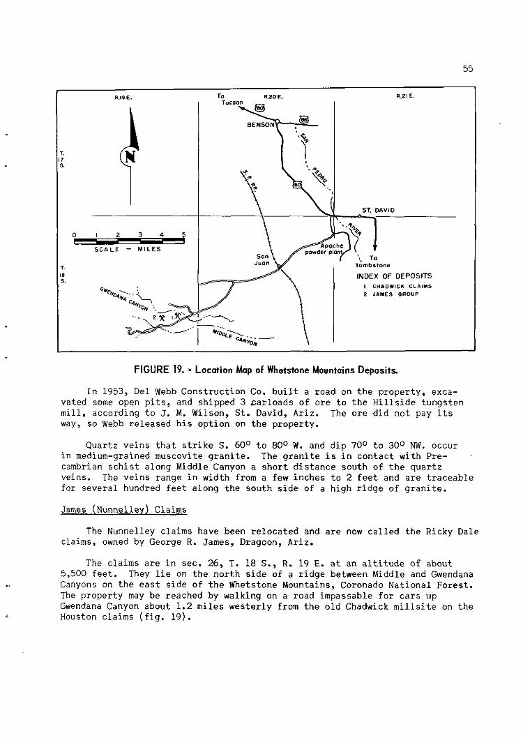
0
S C A L E - M I L E S
--
FIGURE 19. ,- Locotion Map of Whetstone Mountains Deposits
I n 1953, Del Webb C o n s t r u c t i o n Co. b u i l t a road on t h e p r o p e r t y , exca- va t ed some open p i t s , and sh ipped 3 c a r l o a d s o f o r e t o t h e H i l l s i d e t u n g s t e n m i l l , a cco rd ing t o J. M. Wilson, S t . David, Ar iz . The o r e d i d no t pay i t s way, s o Webb r e l e a s e d h i s o p t i o n on t h e p rope r ty .
Q u a r t z v e i n s t h a t s t r i k e S . 60° t o 80° W. and d i p 70° t o 300 NW. occur i n medium-grained muscovite g r a n i t e . The g r a n i t e i s i n c o n t a c t w i t h Pre- . cambrian s c h i s t a long Middle Canyon a s h o r t d i s t a n c e s o u t h o f t h e q u a r t z ve ins . The v e i n s range i n width from a few i n c h e s t o 2 f e e t and a r e t r a c e a b l e f o r s e v e r a l hundred f e e t a long t h e s o u t h s i d e of a h i g h r i d g e of g r a n i t e .
James (Nunnelley) Claims
The Nunnelley c l a ims have been r e l o c a t e d and a r e now c a l l e d t h e Ricky Dale claims, owned by George R. James, Dragoon, Ar iz .
The c l a ims a r e i n sec . 26, T. 18 S., R. 19 E. a t a n a l t i t u d e of about 5,500 f e e t . They l i e on t h e n o r t h s i d e o f a r i d g e between Middle and Gwendana
., Canyons on t h e e a s t s i d e o f t h e Whetstone Mountains, Coronado N a t i o n a l F o r e s t . The p r o p e r t y may be r eached by walking on a road impassable f o r c a r s up Gwendana Canyon about 1.2 m i l e s w e s t e r l y from t h e o l d Chadwick m i l l s i t e on t h e Houston c l a ims ( f i g . 1 9 ) .

Little of the early history of these claims is known. E. C. Nunnelley (deceased) owned them prior to 1943. In 1943, two men named Hill and Graybill were mining and sorting about 200 pounds per shift of tungsten ore that assayed plus 2 percent WO3. The ore was packed 1 mile on burros and then hauled 9.3 miles to Nunnelley's mill on the west bank of the San Pedro River just south of the highway bridge about 0.75 mile west of St. David, Ariz. Several hundred pounds of concentrates was produced during 1943 and 1944. Nunnelley's mill was a small, simple gravity plant.
Nunnelley died about 1945, and the claims have been relocated several times. The date that James relocated the claims is not known.
The mine workings are on the east side of a steep gulch that comes down from the south where the course of Gwendana Canyon changes from south to east about 1.25 miles above its mouth. A medium-grained muscovite granite contacts a tongue of Precambrian schist in this gulch (Also seen in this area were biotite-muscovite granite and pegmatite). The ore occurs in several narrow quartz veins in the muscovite granite a short distance east of the granite- schist contact. The veins are very narrow and can be traced by outcrops for a few hundred feet. The ore mineral is principally wolframite with small amounts of scheelite. This deposit appears to ba an extension of the deposit on the Chadwick claims.
Eveninq Star Claims
Tungsten claims were located a short distance west of the Chadwick and Nunnelley groups in 1937; This property has not been investigated recently, but it is included here for historical reasons. Eldred ~ i l s o a examined this prospect in January 1940, and his description follows:
The Evening Star group of five unpatented claims, held since 1937 by J. Christie, is accessible by 2 miles of road that leads west from Chadwick's claims.
This property was worked in a small way during the (first) World War and has yielded a few thousand pounds of tungsten ore since 1937.
The principal veins are in schist on the northern flank of an eastward-draining canyon, some 400 feet above camp. This schist strikes N. lo0 W., dips SO0 SE., and is intruded on the southeast by granite. Trending N. 20° to 30' E. through the granite and schist are several pegmatite dikes up to 15 or more feet wide. Quartz stringers in the pegmatite and other quartz stringers of N. 10° E. and N. 45O W-.- strike carry a little wolframite. Some of these stringers intersect the main vein, which strikes N. 50° E., dips 30' NW., and ranges from 5 inches to about 2 feet in thickness. This vein shows tungsten mineralization at several places within a length of 300 feet. When visited in January, 1940, it had been
Work cited in footnote 20 (p. 53), p. 46.

opened by s e v e r a l sha l low c u t s and a 32-foot i n c l i n e . I t c o n s i s t s of c o a r s e l y c r y s t a l l i n e grayish-whi te q u a r t z w i t h smal l s c a t t e r e d p a r t i c l e s of wo l f r ami t e , i r o n ox ide , and p y r i t e . M r . C h r i s t i e s t a t e s t h a t a few f e e t below t h e c o l l a r o f t h e i n c l i n e t h e v e i n con ta ined from 1.5 t o 1.9 pe rcen t WO3.
The w a l l rocks of t h e v e i n and of t h e q u a r t z s t r i n g e r s have been s t r o n g l y s e r i c i t i z e d .
Dragoon Mountains
Black P r i n c e and Johnn ie Boy Group
The Black P r i n c e and Johnn ie Boy group o f n i n e unpatented lode c l a i m s i s i n secs . 13, 14, 23, and 24, T. 18 S., R. 23 E., a t an e l e v a t i o n of about 5,300 f e e t . The c l a ims a r e s i t u a t e d on t h e w e s t d r a i n a g e o f t h e Dragoon Mountains abou t 1 mi le n o r t h of t h e wes t p o i n t of Black Diamond Peak. The p r o p e r t y may be reached by road from Tombstone. Go n o r t h e r l y from Tombstone 1.8 m i l e s on U. S. Highway 80 t o t h e Pea rce road v i a Middlemarch Canyon. Follow t h e Pea rce road n o r t h e a s t e r l y f o r 13.4 m i l e s and thence d r i v e n o r t h e r l y on a dim t r u c k t r a i l 0.2 m i l e t o t h e end o f t h e t r a i l a t t h e mine workings ( f i g . 20) .
L i t t l e i s known of t h e h i s t o r y and p roduc t ion r eco rd of t h i s p rope r ty . I n 1950, John F. K r e i s was i n t e r e s t e d i n t h e Johnn ie Boy group. I n J u l y 1953, S tandard Tungsten Corp. l e a s e d f i v e mining c l a i m s and l o c a t e d o r bought f o u r a d d i t i o n a l c la ims . According t o S. C. Hu, p r e s i d e n t , about 1.5 t o n s o f con- c e n t r a t e s was s o l d from o r e t aken from t h e Black P r i n c e by c o n t r a c t o r s and l e s s e e s .
The a r e a i s u n d e r l a i n by a s e r i e s of l i m e s t o n e s and q u a r t z i t e s . H a r q u i l l a l imes tone o v e r l i e s Escabrosa l imes tone . There a l s o i s Bolsa q u a r t z i t e and Abrigo l i m e s one i n t h e a r e a . Quar t z monzonite shows about 0.75 m i l e t o t h e 4 southeas t . 23
A sha l low c u t h a s been made a long a f a u l t c o n t a c t where i n t e n s e a l t e r - a t i o n o f t h e l imes tone h a s t a k e n p lace . The f a u l t s t r i k e s N. 450 E. and d i p s 67O SE. There h a s been much s h e a r i n g a c t i o n . Along t h e f a u l t a r e s p a r s e copper and i r o n oxides . Straw-colored coa r se -g ra ined s c h e e l i t e occu r s sporad- i c a l l y i n t h e s i l i c a t e d l imes tone f o r a t l e a s t 8 f e e t n o r t h of t h e f a u l t his is t h e width of t h e c u t ) . The a r e a su r round ing t h e c u t i s covered w i t h al luvium, s o t h e e x t e n t o f t h e d e p o s i t i s no t known.
Two shal low s h a f t s have been sunk on a s h e a r i n t h e l imes tone abou t 150
., f e e t and 250 f e e t n o r t h e a s t of t h e c u t , r e s p e c t i v e l y . Copper and i r o n o x i d e s and s c h e e l i t e occu r a long t h e s h e a r p l ane , which s t r i k e s n o r t h e r l y and d i p s about 55O E.
G i l l u l y , J., Genera l Geology of C e n t r a l Cochise County, Ariz.: Geol. Survey P ro f . Paper 281, 1956, 169 pp.

R.21 E. Not enough of the
scheelite deposit showed to
TI Scale - Miles
warrant sampling.
Figure 21 is a sketch map of the claims showing major faults and scheelite mineralization.
Swisshelm Mountains
'Biq Four and Valley View Claims
During the couse of this investigation, 2 days were spent in an unsuccess- ful attempt to locate this group of claims. The loca- tion and early history of the claims, and the mine workings, geology, and sam- ple results are abstracted from an unpublished 1942 report by the Bureau.
The property is situ- ated in the Swisshelm Mountains about 8 miles east of Elfrida, Ariz. The Big Four claims cover the top and east side of the ridge on a spur of the mountains. The Valley View claims are on the western slope of the
FIGURE 20. - Location Map of Block Prince and Johnnie same and overlook the Boy Group, Dragoon Mountains. Sulphur Springs Valley.
There is a good road east from Elfrida for 4 miles. From there the road is fair for 3 miles to the foothills of the range. A road has been graded 1.5 miles farther to the lower workings of the property. This is in need of repair but could be put in serviceable condition with a small amount of work.
These claims first were located about 1890 by a man named Paiser, who prospected them for copper and drove the No. 1 adit. Several other short adits, opencuts, and shallow shafts also were dug by Paiser in his search for copper. In 1914 a group of men acquired the property, drove No. 2 adit, and built the road. The claims then were abandoned for years. They were relocated in 1942 by Theodore Williamson after he had discovered the presence of scheelite. Williamson held the property until his death in 1948. The claims

- N o t to s c a l e -
T. 18 5. - R.23E.
LEGEND I//,/,#, SCMEELITE SHOVING
FIGURE 21. - Block Prince and Johnnie Boy Claims, Dragoon Mountains
were r e l o c a t e d aga in i n 1949 and h e l d u n t i l 1952 by a n unknown pa r ty . I n October 1953, Claude Hampton r e l o c a t e d them.
There i s no a v a i l a b l e p roduc t ion r e c o r d , and it i s d o u b t f u l i f any o r e has been shipped from t h e p rope r ty .
No. 1 a d i t i s 347 f e e t long, and o t h e r branching d r i f t s t o t a l 277 f e e t i n length . T h i s a d i t h a s c u t 44 f e e t of t h e o r e body. No. 2 a d i t i s 500 f e e t long, b u t it d i d no t c u t t h e o r e zone a l though t h e f a c e h a s pas sed t h e p o i n t v e r t i c a l l y beneath t h e ou tc rop . The l a s t 5 f e e t of t h e a d i t i s i n d i o r i t e ( f i g 22).
An i n t r u s i o n of monzonite h a s u p l i f t e d and broken t h e l imes tone and s h a l e s , and e f f e c t e d e x t e n s i v e metamorphism a long c o n t a c t s w i t h b l o c k s of t h e sedimentary rocks . The t u n g s t e n occu r s i n t h e c o n t a c t zones a s s c h e e l i t e , which i s evenly d i s t r i b u t e d i n t h e ha rd , s i l i c e o u s , ga rne t -bea r ing rock. There a r e s e v e r a l o u t c r o p s of t h i s m a t e r i a l , which v a r y from a few i n c h e s t o 30 f e e t i n width.

FIGURE 22. - Big Four Mine, Swisshelm Mountains.

The fol lowing samples were taken:
NO. - Location
No. 1 a d i t , 30 f t . S. of contact . . No. 1 a d i t , 40 f t . S. of contact . . No. 1 a d i t , 50 f t . S. of c o n t a c t No. 1 a d i t , 60 f t . S; of contact . . No. 1 a d i t , 70 f t . S. of contact . . D r i f t SW., 30 f t . from a d i t ....... D r i f t SW., d r i f t S., breast....... D r i f t SW., 60 f t . from a d i t ....... D r i f t SW., 70 f t . from a d i t ....... D r i f t SW., D r i f t No. 2 S. 10 f t .
from SW. drift.................. D r i f t No. 2 S., 15 f t . from SW.
drift........................... D r i f t No. 2 S., 20 f t . from SW.
drift........................... D r i f t No. 2 S., 30 f t . from SW.
d r i f t . . ......................... D r i f t No. 2 S., 40 f t . from SW.
drift........................... D r i f t No. 2 S., 50 f t . from SW.
drift........................... Valley V i e w claim, s i d e of
l o c a t i o n hole................... Valley View claim, south outcrop.. Adi t No. 1, 30 f t . S. of con tac t ,
check sample..... ............... Adi t No. 1, 60 f t . S. of c o n t a c t ,
check sample .................... No. 2 s h a f t , chips from around
t o p of shaft....................
Extent of Mate r i a l sample, f e e t
Garnet.. 6.0 .. do.... 5.8 ..do.. .. 6.2 .. do.... 5.0 ..do.. .. 5.0 ..do.. .. 3.0 ..do.. .. 4.0 ..do.. .. 5.5 ..do.. .. 5.5
.. do.... 5.5
do.... .. 3.0
do.... .. 3.0 ..do.. .. 1.5
.. do.... 6.0
.. do.... 5.0
.. do............
61
wo3 percent
0.22 .07 .01 .17 .29 .03 . O 1 .01 .01
.42
-62
.39
.17
.27
.49
-21 -01
.26
.9
.1
Figures 22 and 23 show t h e l o c a t i o n s of t h e s e samples.
Mineral Reserves M i l l
The Mineral Reserves Co., Ltd. has a rungsten concen t ra re process inq p l a n t s i t u a t e d b few hundred f e e t west of t h e r a i l r o a d t r a c k s on Ninth Avenue i n Douglas, Ariz.
The p l a n t was b u i l t o r i g i n a l l y by David P. McConnell f o r Anthony Mart inol ich , a San Francisco sh ipbu i lde r . I t was b u i l t t o upgrade Mexican tungs ten concen t ra tes f o r r e s a l e i n t h e United S t a t e s . The p a r t i c l e separa t ion p l a n t was completed i n March 1956. L a t e r t h e Mineral Reserves Co., Ltd. ob ta ined a l e a s e wi th purchase opt ion. The p l a n t i s supervised by David P. McConnell and James W. Marino.


The d a i l y c a p a c i t y i s 25 tons . The p l a n t h a s good equipment t o upgrade t h e Mexican c o n c e n t r a t e s by any one of a number of methods. There a r e t a b l e s f o r g r a v i t y c o n c e n t r a t i o n , f l o t a t i o n u n i t s , a magnetic s e p a r a t o r , a s t a t i c s e p a r a t o r , a r o a s t e r , and ac id - l each ing equipment. When t h e w r i t e r v i s i t e d t h e p l a n t i n June 1957 t h e p l a n t was be ing remodeled and e n l a r g e d t o add equipment f o r t h e p roduc t ion of s y n t h e t i c s c h e e l i t e .
Although t h e Mineral Reserves Co., Ltd. owns two t u n g s t e n p r o p e r t i e s i n Mexico, most of t h e c o n c e n t r a t e s t r e a t e d a t t h e p l a n t have been purchased from o t h e r Mexican producers . To d a t e , about 85 t o n s of t h e c o n c e n t r a t e s w i th average. g rade of 65 p e r c e n t W03 h a s been produced.
Pima County
E a s t e r n P a r t of t h e Papago I n d i a n Rese rva t ion
T h i s a r e a i n which t h e t u n g s t e n m i n e r a l i z a t i o n occu r s i s w i t h i n t h e Papago I n d i a n Rese rva t ion i n t h e f o o t h i l l s of t h e Quinlan and Baboquivar i Mountains, some 50 miles wes t of Tucson, Ar iz . ( f i g . 24). The a r e a i s unsur- veyed, b u t t h e l o c a t i o n of each of t h e p r o p e r t i e s i s g i v e n i n t h e d e t a i l e d r e p o r t s by p r o j e c t e d s e c t i o n , township and range.
A R I Z O N A i PlMA COUNTY k2-I
FIGURE 24. - Tungsten Deposits, Eastern Part of Papogo lndion Reservation, Pimo County, Ariz.

The fo l lowing road l o g g i v e s b a s i c mi l eages t o t h e v a r i o u s t u r n o f f s t h a t a r e mentioned i n t h e r e p o r t :
Mi l e s - Turnoff 0.0.. J u n c t i o n U.S. Highway 89 and S t a t e Highway 8 6 (Tucson-Ajo
road ) i n South Tucson, t r a v e l i n g wes t on Highway 8 6 ( toward Ajo) .
47.0.. J u n c t i o n of F o o t h i l l Truck T r a i l go ing t o t h e s o u t h .
53.0.. J u n c t i o n t o mine a c c e s s road , going t o t h e e a s t .
53.6.. Tungsten c o n c e n t r a t i n g m i l l on n o r t h s i d e o f road .
61.5.. S e l l s J u n c t i o n .
A l l mines o r p r o s p e c t s d e s c r i b e d i n t h i s r e p o r t a r e a c c e s s i b l e from t h e 53.0-mile j u n c t i o n by t r a v e l i n g e a s t 6.2 m i l e s from t h e highway t o t h e j u n c t i o n of t h e F o o t h i l l Truck T r a i l n e a r San Juan v i l l a g e . Mi leages a r e g iven from t h i s p o i n t , a s t h e v a r i o u s a c c e s s r o a d s o r i g i n a t e a long t h e t r a i l , e i t h e r n o r t h o r s o u t h of t h e San Juan j u n c t i o n . T h i s j u n c t i o n i s 6 m i l e s from Highway 86 v i a t h e t r a i l road. T h i s s e c t i o n of t h e road i s i n poor c o n d i t i o n .
Discont inuous t u n g s t e n m i n e r a l i z a t i o n i s p r e s e n t i n a b e l t about 1 m i l e wide and a t l e a s t 6 m i l e s long i n an a r e a sou th of S t a t e Highway 8 6 ( ~ u c s o n - Ajo road) and e a s t of t h e o l d F o o t h i l l Truck T r a i l . The topography o f t h i s a r e a i s shown on t h e Baboquivar i Peak quadrang le s h e e t , from which t h e p o s i t i o n of each of t h e d e p o s i t s was e s t a b l i s h e d . The m i n e r a l i z a t i o n t h a t h a s been prospected i s w i t h i n an a l t i t u d e range of from 3,050 t o 3,750 f e e t ( f i g . 25) .
A second a r e a (Gian t c l a i m s ) , l o c a t e d some 1 7 m i l e s f a r t h e r sou th , a l s o c o n t a i n s s c h e e l i t e m i n e r a l i z a t i o n . T h i s occu r rence i s t r e a t e d a s a s e p a r a t e chap te r i n t h i s r e p o r t .
A l l c l a ims d i s c u s s e d i n t h i s r e p o r t were l o c a t e d when t h e r e were no r e s e r v a t i o n r e s t r i c t i o n s and t h e usua l procedure of l o c a t i n g c l a i m s p r e v a i l e d . None of t h e c l a ims h a s been pa t en ted . By an Act of Congress t h e Papago Rese rva t ion was c l o s e d t o r e g u l a r mine ra l e n t r y on May 22, 1955.
The d e p o s i t s occu r i n s h e a r s o r f r a c t u r e s , and t h e m i n e r a l i z a t i o n i n gene ra l i s i n widely spaced , narrow bands. M u l t i p l e zones t h a t could be mined from a c e n t r a l l y s i t u a t e ' d working a r e found a t o n l y two p l a c e s ; of t h e s e , t h e Big Banana was a c t i v e l y engaged i n mining when t h e s e c l a i m s were v i s i t e d , and t h e Yellow S t a r was i d l e and v i r t u a l l y undeveloped. L ike most o f t h e schee- l i t e d e p o s i t s known e l sewhere , t h e l e n s e s o f o r e a r e d i s c o n t i n u o u s i n l a t e r a l e x t e n t a s w e l l a s i n depth.
I n t e n s i v e p r o s p e c t i n g d o u b t l e s s would d i s c o v e r many more s i m i l a r d e p o s i t s , b u t because of t h e p r o h i b i t i v e r e s t r i c t i o n s p l aced on mine ra l e n t r i e s i n t h e Papago I n d i a n Rese rva t ion s i n c e mid-1955, i t i s u n l i k e l y t h a t u n l o c a t e d ground w i l l be p rospec ted . The p o t e n t i a l r e s e r v e s of s c h e e l i t e i n t h e e n t i r e a r e a

FIGURE 25. - Location Mop of Tungsten Deposits, Northern Baboquivori Mountains Area.

undoubtedly are large, but much of the scheelite is in small, scattered deposits that cannot be mined at low cost.
Of the 18 properties examined, only 4 have made a production of $20,000 or more; 2 of these still were on a production basis in February 1957. Production has been curtailed in this area for lack of nearby milling facil- ities. A small mill of 1-ton-per-hour capacity was constructed on the Tucson-Ajo highway late in 1955. The Big Banana ore was milled regularly on a custom basis. Occasionally San Juan ore was milled, but the mill capacity was so low that both mines were accumulating stockpiles of ore. The mill is approximately 9 miles from the mines.
The old mill, which had been operated by the Cinderra Mining 8 Engineering Co., was taken over by the C. G. Glasscock-Tidelands Oil Co. some time after the field examination was made in February 1957. According to M. J. McKnight, superintendent, a larger mill with an improved flowsheet was constructed and put in operation in May 1957. Operations of the mine and mill were suspended in August 1957.
In this area, a belt of sedimentary rocks intruded by dikes and irregular patches of rhyolite has been highly metamorphosed. The dominant structural feature is a wide northwesterly striking fault system, the elements of which normally dip steeply to the west. The secondary faulting and intense shearing between the major faults probably are the result of tensional adjustment. All the known ore bodies are within these zones of structural disturbance, and seem to be localized along the tension shears in the metamorphosed sediments.
The sedimentary series are thought to have been composed of sandstone members of varying composition, interbedded to a minor extent with limestone layers. The fractures formed by the tensional shearing may cut the bedding or may appear as bedding-plane slips.
The sediments have been metamorphosed to such an extent that some members of the original sandstone series visually appear to be igneous, owing to texture and the presence of dark minerals, such as hornblende and biotite. However, microscopic examination of more than 20 rock specimens has shown that only 2 represented rhyolite. The remainder were classified as quartzite. Locally some of these beds are schistose in character.
Rhyolite was noted only at the southern end of the area near the Big Banana mine, but it is possible that smaller occurrences were not recog- nized in the area to the north. Narrow dikes of aplite, later than the meta- morphism, have been intruded int.0 the rocks throughout the area.
Epidote and various types of garnet are common constituents of the rocks. Small amounts of fluorspar were noted at two of the deposits. Copper oxide staining is prevalent in virtually all of the deposits.
Probably because of the greater ease of entry, the mineralizing solutions favored porous zones, and scheelite occurrences usually are localized along such bands rather than with the massive rock. Hydrothermal alteration has

f u r t h e r a f f e c t e d t h e s e bands, s o t h a t t h e s c h e e l i t e u s u a l l y i s i n l e n t i c u l a r b o d i e s i n a f a i r l y s o f t , g r a n u l a r , o f t e n p u l v e r u l e n t mat r ix . Thin c o a t i n g s o r smears of s c h e e l i t e o c c a s i o n a l l y ex tend i n t o t h e f r a c t u r e p l a n e s of a d j a c e n t mass ive rocks .
The s c h e e l i t e o c c u r s a s d i s c r e t e p a r t i c l e s , seldom l a r g e r t h a n a match head and u s u a l l y much s m a l l e r , and o f t e n a s mere specks . Most of t h e schee- l i t e i s molybdenum b e a r i n g and f l u o r e s c e s a ye l low c o l o r under t h e u l t r a v i o l e t lamp.
I t i s r e p o r t e d t h a t s c h e e l i t e m i n e r a l i z a t i o n i s p r e s e n t i n s i m i l a r meta- morphic r o c k s h i g h e r i n t h e mountains, 2 o r 3 m i l e s n o r t h e a s t of t h e Big Banana mine. No c l a ims have been l o c a t e d t h e r e because of d i f f i c u l t a c c e s s i b i l i t y .
Northern Area
Biq Banana Mine (C. G. Glasscock-Tidelands O i l Co.)
The Big Banana p r o p e r t y , c o n s i s t i n g of f o u r con t iguous , p a r t l y over- l app ing c l a i m s , i s s i t u a t e d i n approximate sec . 32, T. 17 s., R . 7 E . , unsur- veyed, a t an a l t i t u d e of 3,700 f e e t . The mine i s a c c e s s i b l e by a 0.7-mile road b ranch ing e a s t from t h e F o o t h i l l Truck T r a i l 1.6 m i l e s s o u t h of t h e San Juan j u n c t i o n .
Wm. H. Coplen purchased t h e Maud E c l a im and l o c a t e d t h e t h r e e Big Banana c l a ims e a r l y i n 1954 and produced approximate ly $25,000 wor th o f t u n g s t e n c o n c e n t r a t e s .
I n June 1955, t h e C. G. Glasscock-Tidelands O i l Co. e n t e r e d i n t o a purchase c o n t r a c t w i th Coplen, developed t h e mine, and through 1956 had produced an e s t ima ted $50,000 worth of c o n c e n t r a t e s .
The Banana o r e zone l i e s w i t h i n metamorphosed q u a r t z i t i c r o c k , a d j a c e n t t o and e a s t of an i r r e g u l a r , i n t r u s i v e mass of somewhat metamorphosed r h y o l i t e . The g e n e r a l t r e n d of t h e m i n e r a l i z e d zone i s S. 15' E. I t i s 1 ,000 f e e t o r more i n l e n g t h . The rocks a r e i n t e n s e l y s h a t t e r e d . Within t h e m i n e r a l i z e d zone, t h e o r e s h o o t s appea r t o be a r r anged i n an en echelon p a t t e r n , and t h e i n d i v i d u a l s h o o t s s t r i k e N. 10' t o 20° W. and d i p eastward.
No t r a n s i t survey h a s been made of t h e e n t i r e Big Banana workings, b u t f o r t h e purpose of t h i s r e p o r t f i g u r e 26 h a s been compiled from t h e company's f ragmentary Brunton survey maps.
Lower Cut Adi t . - From t h e f a c e of an opencut t h a t had produced o r e , t h e L o , ~ e r Cut a d i t was d r i v e n southward f o r 100 f e e t , p a s s i n g i n t o a lmost ba r r en rock a t about 60 f e e t . A t 40 f e e t from t h e p o r t a l a wide 500 i n c l i n e d winze was sunk on t h e o r e shoot . A t t h e bottom t h e a n g l e f l a t t e n e d t o a n e a r l y h o r i z o n t a l p o s i t i o n . McKnight s t a t e d t h a t t h e o r e from a 6- t o 8 - foo t zone averaged 0.5 p e r c e n t down t h i s i n c l i n e . A 40-foot d r i f t t o t h e s o u t h e s s t produced o r e f o r about h a l f i t s l eng th . Ore was be ing mined from a d r i f t i n

/ :: S E C T I O N A-A
FIGURE 26. - Plan and Section, Big Banana Mine.
t h e o p p o s i t e d i r e c t i o n , which on January 1 0 , 1957, had been advanced 20 f e e t . A t t h i s l e v e l some p y r i t e was p r e s e n t i n t h e o r e zone. When t h e o r e was m i l l e d , most i f n o t a l l o f t h e p y r i t e remained i n t h e c o n c e n t r a t e .
Ore from t h e winze was h o i s t e d , trammed t o an o r e dump, and p laced i n t r u c k s by an end l o a d e r . '
A c h a r a c t e r sample from t h e bottom o f t h e winze (15045-A) was micro- s c o p i c a l l y de termined t o be a q u a r t z i t e , a s was one (15045-B) t a k e n on t h e s u r f a c e 50 f e e t e a s t of t h e a d i t p o r t a l .
Middle Cut. - Approximately 700 f e e t t o t h e s o u t h e a s t and 100 f e e t h i g h e r , an opencut h a s produced c o n s i d e r a b l e o r e . A t f l o o r l e v e l t h e c u t measured 160 f e e t l ong by about 35 f e e t wide, and t h e h i g h s i d e measured 30 f e e t . Consid- e r a b l e s o r t i n g was r e q u i r e d t o upgrade t h e p roduc t ; a l l l a r g e , ha rd f r agmen t s were r e j e c t e d . Probably c e r t a i n p a r t s of t h e excavated m a t e r i a l t h a t d i d n o t lamp s c h e e l i t e were a l s o r e j e c t e d .
D r i f t s were be ing d r i v e n a long t h e zone of m i n e r a l i z a t i o n from each end of t he c u t when t h e d e p o s i t was v i s i t e d . E a r l y i n December 1956, when t h e no r th d r i f t was 20 f e e t deep and t h e south end was i n p r e p a r a t i o n f o r d r i f t i n g , a combined muck sample c o n s i s t i n g of 50 pounds from each p l a c e a s sayed t h e fo l lowing pe rcen tages : 0.06 WO3, 0.006 MoO3, and 0.03 Cu. E v i d e n t l y miner- a l i z a t i o n a s l e a n a s t h i s would have been d i sca rded . A s of January 10 , 1957, each of t h e d r i f t s had been d r i v e n 125 f e e t . The m a t e r i a l from t h e n o r t h d r i f t was s e n t t o t h e m i l l , b u t t h e f a c e of t h e sou th d r i f t was below m i l l i n g

grade. The ore was mechanically mucked into mine cars and trammed to a 50- foot-long inclined chute, from the bottom of which trucks were loaded for the 9-mile haul to the mill.
A sample (15043-A) taken on a rock outcro just east of the middle cut was identified as quartzite. A second sample r15043-8) taken about 50 feet west of the cut was identified as metamorhposed rhyolite porphyry.
Upper Cuts. - A cut about 200 feet farther southeast and 50 feet higher had a maximum depth of 20 feet and a floor dimension of 60 feet by 10 feet and another 30 feet higher was about 70 feet long and was cut into the hill for 20 feet. Both these cuts were producing ore for the mill in January 1957. Trucks were filled by an end loader.
A combined 50-pound muck grab from each end of the first-mentioned pit assayed 0.25 percent NO3, 0.021 percent MoO3, and 0.03 percent Cu. A 35-pound muck sample taken across the length of the face of the upper working assayed the following percentages: 0.25 WOg, 0.018 MoO3, and 0.02 Cu.
The hillside had been stripped by bulldozing along the zone for approxi- mately 200 feet south of the upper cut to the top of the saddle, some 30 feet higher. This area lamped some scheelite. South of the saddle, the mineral- ization appeared to be cut off by rhyolite for about 1,000 feet. Although scheelite-bearinq metamorphic rocks were reported in this southern area, there was no access road and no exploration had been done.
Main Adit. - From a point 200 feet southwest of the lower cut adit and 10 feet lower, an adit was driven S. 30' E. for a distance of 1,000 feet. It was poorly located and intersected only occasional traces of mineralization on shear planes. A rock sample (15044), taken 900 feet from the portal, was identified as slightly metamorphosed rhyolite porphyry.
Evidence of mineralization was noted 450 feet from the adit and followed westward. A small amount of low-grade ore was taken from part of the 170 feet of total drifting. This ore was stockpiled on the surface for possible future milling. A 50-pound sample taken around the edges of the pile assayed the following percentages: 0.13 WO3, 0.011 Moo3, and 0.02 Cu.
McKnight stated that long-hole drilling late in January 1957 had indi- cated an 8-foot ore zone at least 250 feet long near the portal and 45 feet to the east.
Linda Claim
The Linda claim is situated in approximate sec. 29, T. 17 S., R. 7 E., unsurveyed, and is said to adjoin the Banana property on the north and the Sparks property on the west. It was located by Charles Traister in 1954 and is accessible from the Sparks camp by a half-mile bulldozer trail up the north side of the gulch.
I f t h e Banana s t r u c t u r e ex tends a c r o s s t h e gulch , it i s no t ev iden t from s u r f a c e ou tc rops . The on ly e x p l o r a t i o n noted i n February 1957 was a sha l low b u l l d o z e r c u t on t h e h i l l s i d e , and no sample was taken .
Sparks Mine
The Sparks p r o p e r t y c o n s i s t s of 27 con t iguous p a r t l y ove r l app ing c l a i m s i n approximate secs . 29, 30, and 31, T. 17 S . , R. 7 E., unsurveyed. The c la ims were l o c a t e d by George W. Sparks i n 1954-55. The campsi te was j u s t e a s t of t h e F o o t h i l l Truck T r a i l a t a p o i n t 1 .2 m i l e s sou th of t h e San Juan junc t ion . The p r i n c i p a l d e p o s i t , J u a n i t a No. 9 , was mined by l e s s e e s who a r e s a i d t o have produced 100 t o n s of 20.5 p e r c e n t s c h e e l i t e ore .
E a r l y i n 1957 t h e p r o p e r t y was l ea se -op t ioned by E a r l Sands and asso- c i a t e s , who were p r e p a r i n g t o mine t h i s d e p o s i t a s h o r t d i s t a n c e n o r t h of t h e campsite .
The s c h e e l i t e m i n e r a l i z a t i o n occu r s i n a f r a c t u r e zone t h a t s t r i k e s S. S. 20' W. i n a h o r n f e l s fo rma t ion , which b e f o r e metamorphism probably was an impure q u a r t z i t e . The p r i n c i p a l workings c o n s i s t e d of a 30-foot a d i t ex tending from a h i l l s i d e c u t . About h a l f t h e l e n g t h of t h e a d i t had been s toped t o t h e su r f ace . The zone t h a t was mined was 4 t o 5 f e e t wide and d ipped 70' SE. I n t h e f l o o r of t h e c u t a t t h e p o r t a l , a 20-foot t r e n c h 10 f e e t deep had been excavated a long t h e d i p of t h e m i n e r a l i z a t i o n .
The f r a c t u r e zone had been prospected by an opencut about 25 f e e t below t h e a d i t , and by a 10-foot s h a f t approximate ly 100 f e e t h i g h e r n e a r t h e t o p of a h i l l . A sample chipped a c r o s s t h e -/-foot width of t h i s s h a f t assayed 0.11 p e r c e n t W03. Truck t r a i l s l e a d t o numerous o t h e r c la ims of t h e qroup, b u t no o t h e r workings were found excep t b u l l d o z e r c u t s a t v a r i o u s p l aces . The a r e a covered by t h e s e c l a i m s i s e a s t and south of t h e J u a n i t a No. 9.
Brown P r o s p e c t
I n e a r l y 1954 Vance J. Brown l o c a t e d f o u r c l a ims (Big J u a n i t a group) t h a t a r e s i t u a t e d i n approximate secs . 29 and 30, T. 17 S., R. 7 E., unsurveyed. The p r o p e r t y i s n o r t h e a s t o f t h e Sparks mine and i s a c c e s s i b l e by a 1/2-mile p i l o t road eas tward from t h e Sparks camp.
A t t h e t ime of t h e examinat ion , e a r l y i n January 1957, t h e p r i n c i p a l work had been conf ined t o t h e No. 1 c l a ims where a n o r t h w e s t e r l y t r e n d i n g zone i n q u a r t z i t i c format ion con ta ined ep ido te , z o i s i t e , g a r n e t , and s t r i n g e r s of secondary c a l c i t e . A number of narrow a p l i t e d i k e s c u t i r r e g u l a r l y through t h e format ion .
A b u l l d o z e r c u t had exposed a f a c e about 50 f e e t long t o a maximum h e i g h t of 15 f e e t . On t h e h i l l s i d e above t h i s f o u r sha l low p i t s had been excavated i n a d i s t a n c e of about 150 f e e t . Brown s t a t e d t h a t from t h i s work he produced 3.5 t o n s of o r e t h a t gave 50 pounds of 62-percent s c h e e l i t e concen t r a t e s . There had been no p roduc t ion from t h e o t h e r t h r e e c l a ims of t h e group, s o t h e y were no t examined.

Last Chance Claim
The Last Chance claim in approximate sec. 30, T. 17 S., R. 7 E., unsur- veyed, is accessible by a 0.2-mile pilot road turning south from the San Juan mine road 0.4 mile from the Foothill Truck Trail. The claim originally was located by Earl Hicklin, Jr., in September 1954, and was later sold to D. G. Wheeler, who produced about 20 tons of ore conatining *0.5 percent WO3. Wm. H. Coplen owned the claim in January 1957.
The claim covers a small knoll composed of highly fractured quartzitic material in which the predominent shearing strikes east-west and dips 55O N. On the north side of the knoll, prospecting had been confined to a 3-foot metamorphosed scheelite-bearing band that appears originally to have been limestone interbedded within sandstone layers. A 15-foot shaft, now partly backfilled, was sunk on this band, which strikes southeast. At the surface the dip is nearly vertical, but a few feet below the surface the bed flattens and takes an easterly dip. Approximately 20 feet north of the shaft, bull- dozer stripping had exposed material, now metamorphosed to a fine-grained siliceous rock containing ferromagnesian minerals that originally may have represented an intrusive igneous body. It may have been only a sandstone layer rich in iron minerals, however.
On the other side of the knoll about 100 feet south of the shaft a very shallow pit exposed a similar mineralized occurrence.
A chip sample across the %-foot width of the shaft and another sample across the &foot pit were combined and assayed 0.26 percent WO3.
The property was examined in February 1957.
San Juan Mine
The San Juan property consists of four contiguous claims situated in approximate sec. 30, T. 17 S., R. 7 E., unsurveyed. It is accessible by a 0.6-mile road branching east from the Foothill Truck Trail 0.3 mile south of the San Juan junction. The claims originally were located by Wm. H. Coplen in 1951,' and sold to Chas. M. Taylor and A. L. Gorman the following year. The latter parties excavated a number of pits and cuts, and sank.a 42-foot inclined shaft with stub drifts at the bottom. A small amount of tungsten was produced by this work.
In 1954 Taylor and Gorman sold the property back to Coplen, who then made a production of approximately $21,000.
In April 1956, a lease with option to purchase was executed.on three of the claims with A. K. Wilson, Jr., who was operating the property early in 1957 for the Mountain States Uranium Co. The production of this company, plus the estimated value of the tungsten in the ore stockpile, was on the order of $7,500.

The deposit lies within a faulted zone in quartzitic rock that has been metamorphosed to hornfels. The zone is sheared and shattered and contains considerable amounts of argillaceous alteration products. Most of the schee- lite mineralization is confined to a discontinuous band ranging in thickness from 6 inches to 3 or 4 feet within the fault zone. The general course is slightly east of north, but development has shown that the band is sinuous both in strike and dip. The latter ranges from 30° to 60° E.
The deposit was opened by a sidehill cut from which a short adit was driven northward. Shallow underhand stoping was done along the cut, and two 50-foot inclined shafts, 100 feet apart, were sunk on the vein and connected by a bottom level. Very little stoping was done on this level. At the time of the examination in January 1957 production was confined to the north (main) shaft, where drifts were being extended north and south on the 32-foot level. The 45-foot drift to the north had been stoped nearly to the surface. The 25- foot south drift was being extended.
The mineralized zone had been stripped by bulldozer work for approximately 500 feet to the south. Wagon drilling indicated an increase in mineralization about 300 feet south of the main shaft, and preparations were being made to sink a shaft at this place.
A stockpile of k0.5 percent ore had been accumulated and was being milled on a custom basis as facilities at the Cinderra mill were available.
A sample chipped across 20 feet of fractured footwall material 50 feet north of the main shaft assayed 0.18 percent WO3.
In 1953, samples were cut across the width of the vein from available openings for a vein length of 300 feet. The weighted assay value of 7 samples was 0.34 percent WO3. These were taken over vein widths ranging from 0.9 to 14 feet and averaged 4.5 feet.
It is reported that the Mountain States Uranium Co. relinquished its option in mid-1957.
Jezebel Mine
The Jezebel mine is accessible by a 0.5-mile road that turns east from the Foothill Truck Trail about 200 yards north of the San Juan junction and is situated in approximate sec. 19, T. 17 S., R. 7 E., unsurveyed. The Jezebel No. 1 claim was located by Earl Francis in January 1954, and later sold to James E. Thornton of Tucson. Several lessees are said to have produced a total of approximately 600 tons of ore from which the concentrates are esti- mated to have been worth $25,000.
The principal workings consist of a stope 50 feet long and half that wide, bordered on the north by a stub adit and on the west and south by deep bull- dozer cuts. It is likely that ore was taken from an area of at least 60 by 80 feet.
The mineral ized zone wi th in t h e s tope averages about 4 f e e t t h i c k , d ipping lo0 t o 15O SE. The g r e a t e s t concen t ra t ion of s c h e e l i t e was i n t h e bottom 12 t o 18 inches of t h e zone, where a l t e r a t i o n has been g r e a t e s t and t h e s i l i c e o u s m a t e r i a l i s vuggy and g ranu la r . Eight samples chipped a c r o s s t h e o r e zone a t v a r i o u s p l a c e s i n t h e s tope were combined and gave an assay va lue of 0.67 percent WO3. The o re zone h a s been dragged down on t h e south s i d e by a f a u l t s t r i k i n g S. 80' E. and dipping 55' S. The o r e was followed downward under t h e hanging wal l of t h e f a u l t f o r a t l e a s t 15 t o 20 f e e t below t h e f l o o r of a bul ldozer c u t , bu t caving h a s v i r t u a l l y f i l l e d t h i s p a r t of t h e workings.
The rock immediately n o r t h of t h e f a u l t i s h igh ly a l t e r e d and con ta ins abundant c lay wi th s l i c k e n s i d e s i n va r ious d i r e c t i o n s i n d i c a t i n g much movement. The country rock o u t s i d e of t h e f a u l t e d a rea i s q u a r t z i t i c and somewhat s c h i s t o s e i n c h a r a c t e r (15101).
About 175 f e e t t o t h e nor th a small l e n s of minera l i za t ion was opened from a s t u b a d i t by a small underhand s tope , now caved. I t i s repor ted t h a t t h e narrow o r e zone took a decided p i t c h t o t h e south. A ch ip sample a c r o s s 4 f e e t of t h e face of t h e a d i t assayed 0.12 percen t W03.
The proper ty was i d l e when v i s i t e d i n December 1956.
According t o Thornton, t h e m a t e r i a l t h a t has f i l l e d t h e workings nex t t o t h e hanging wal l i s b l a s t e d d e b r i s covering o r e t h a t would run over 10 percent WO3. Beneath t h i s d e b r i s a s h a f t was sunk 15 t o 20 f e e t below t h e l e v e l of t h e f l o o r made by t h e bu l ldozer , and Thornton s t a t e s t h a t t h e e n t i r e s h a f t was i n ore. A miner i s r epor ted t o have dug a p rospec t ho le 6 o r 7 f e e t deep beneath t h e f l o o r of t h e bu l ldozer c u t . Ore i n t h i s hole was es t imated by t h e miner t o run 5 t o 7 percent WO3.
Yellow S t a r Mine
The Yellow S t a r workings a r e a c c e s s i b l e by a 0.4-mile a c c e s s road t h a t branches e a s t from t h e F o o t h i l l Truck T r a i l 0.5 mi le nor th of t h e San Juan junction. The proper ty , i n approximate sec. 19, R. 7 E., and sec. 24, R. 6 E., T. 17 S., unsurveyed, c o n s i s t s of two claims. The o r i g i n a l l o c a t i o n s were made i n l a t e 1952: Yellow Dragon No. 1 by E a r l F ranc i s , and No. 2 by Francis and Wm. H. Coplen. L a t e r Coplen bought Franc i s ' i n t e r e s t , produced about $2,000 worth of s c h e e l i t e concen t ra tes , and then sold t h e p roper ty t o W. F. R. G r i f f i t h . G r i f f i t h r e l o c a t e d t h e c la ims a s New Dragon Nos. 1 and 2, made a considerable product ion, and i n March 1955 lease-optioned t h e proper ty t o the Standard Tungsten Carp.
The p r i n c i p a l workings c o n s i s t of a 90-foot north-bearing a d i t connecting with a 60-foot i n c l i n e d s h a f t . The l a t t e r was s t a r t e d on a mineral ized s t r i n g e r d ipping southwest. A t about 20 f e e t below t h e s h a f t c o l l a r t h e d i p of the s t r i n g e r f l a t t e n e d , b u t t h e s h a f t was continued a t minus 40' f o r 40 f e e t u n t i l it c u t i n t o t h e south end of a f l a t - l y i n g c a v i t y , 2 t o 3 f e e t h igh by 10 t o 12 f e e t wide, t h e w a l l s of which contained some s c h e e l i t e miner- a l i z t i o n . The a d i t then was d r iven from t h e south s i d e of t h e r i d g e t o connect
with the bottom of the shaft. The adit encountered and followed the flat- lying mineralized contact along which the cavity was found. Mineralization was confined mainly to a friable, somewhat granular bed up to 2 feet wide, and was mined about 10 feet on each side of the adit. Rock samples (15111 and 15112) taken of the formation above and below this ore bed were identified as feldspathic quartzite. No exploration was conducted in the cavity north of the bottom of the shaft.
On the opposite side of the ridge, some 250 feet to the north, ore was produced from an opencut about 100 feet wide, where nearly vertical southeast- trending shears contained numerous narrow stringers of mineralization. A sample chipped across 50 feet of this zone assayed 0.19 percent WO3. The rock (15107) was identified as metamorphosed feldspathic quartzite. An inclined adit was driven southwesterly for 35 feet along a mineralized fault near the center of the opencut. The east wall of the fault had the appearance of meta- morphosed igneous rock, but was identified as quartzite (15109). A mineralized bed cut in the floor was followed by a branch drift for 40 feet to the south- east. This drift broke into a small cavity. A sample chipped vertically for 4 feet across the mineralized bed assayed 0.69 percent WO3, and the host rock (15117) was quartzite. This bed also was mined from a small, now inaccessible, stope opened from the face of the cut. The stope likewise broke into a cavity.
A pit, 250 feet southwest of the north adit, is 6 by 14 by 16 feet deep, and another smaller pit is 25 feet farther to the west. These pits have been excavated on a zone of closely spaced southeast-trending shears. Chip samples across 14 feet in the larger pit and 8 feet in the smaller pit assayed 0.35 and 0.21 percent, respectively, and the rock was microscopically identified as quartzite.
Extensive bulldozer stripping has been done about 400 feet north of the north adit, where a bed 4 to 6 feet thick reportedly contained mineralization. No sample was taken here, as the bulldozer work had obscured the formation.
It is estimated by W. H. Coplen that the work of various operators has produced approximately $20,000 worth of scheelite concentrates from about 700 tons of ore.
The property was idle when visited in December 1956.
Independence Group
The Independence group, consisting of two contiguous claims, is situated in approximate sec. 24, T:l7 S., R. 6 E., unsurveyed. The property is on the east side and adjacent to the Foothill Truck Trail at a point 1.1 miles north of San Juan junction.
Each claim is said to have produced about 5 tons of ore.
Independence No. 1. - The Independence No. 1 claim immediately south of the end of the road originally was located by Walter N. and Eugene D. Calvert, and Vance J. and Wm. S. Brown on November 4, 1953. In the location monument

t h e r e a l s o i s a l o c a t i o n n o t i c e d a t e d November 12, 1954, s t a t i n g t h a t t h e New Dragon No. 4 c l a im i s r e l o c a t e d "on f o r f e i t and abandoned grounds" by W. F. R. G r i f f t h .
The c o n s i d e r a b l e amount of b u l l d o z e r s t r i p p i n g h a s o b l i t e r a t e d t h e o u t - c rops and f i l l e d an o r i g i n a l c u t and d i s c o v e r y s h a f t ; consequen t ly , no samples were t aken .
Independence No. 2. - T h i s c l a im was l o c a t e d by Wal ter N. and Eugene D. C a l v e r t , and Vance J. and Wm. S. Brown on November 7, 1953, and l a t e r was purchased by Webster L. F i c k e t t o f Tucson and a n a s s o c i a t e . A t t h e n o r t h s i d e of t h e road a p a r t l y caved 12 - foo t s h a f t w i t h a s t u b d r i f t a t t h e bottom h a s been sunk i n sheared format ion , t h e f r a c t u r e s of which s t r i k e N. lo0 W. and d i d i p 70 E. The rock i s somewhat a l t e r e d and f r i a b l e and c o n t a i n s c o a t i n g s of copper oxides . A sample was chipped a long t h e 1 2 f e e t of l e n g t h of t h e wes t s i d e o f t h e workings. T h i s assayed 0.056 p e r c e n t WO3.
A second s h a f t some 500 f e e t t o t h e no r thwes t i n a s i m i l a r s h e a r zone was sampled a c r o s s t h e format ion , a s say ing 0.021 p e r c e n t W03. An opencut 50 f e e t f a r t h e r nor thwest cona t ined a p p r e c i a b l e q u a n t i t i e s o f c h r y s o c o l l a , some f l u o r i t e , l i m o n i t e , and ma lach i t e , and a few specks o f s c h e e l i t e . The owners r e p o r t t h a t a sample from t h i s opencut a s sayed 0.12 ounce o f go ld , 8.4 ounces of s i l v e r , and 13.05 p e r c e n t copper. T h i s m i n e r a l i z a t i o n was con- f ined t o a narrow f r a c t u r e s t r i k i n g nor thwest and d ipp ing n o r t h e a s t . A sma l l a r ea a t t h e end of t h e road was s t r i p p e d w i t h a b u l l d o z e r .
Rushbey P rospec t
The Rushbey p r o p e r t y , a p p a r e n t l y c o n s i s t i n g of t h r e e c l a ims , was l o c a t e d i n January 1954 by Dewit t T. Rushbey and E. L. H i c k l i n . The l o c a t i o n monument and workings of t h e B i r thday c l a im were found, and t h e monument con ta ined an a f f i d a v i t f o r 1955 assessment work on t h i s and two o t h e r c l a ims , t h e l a t t e r of which were no t found. The c l a ims a r e i n approximate sec . 19 , T. 1 6 S., R. 7 E. , unsurveyed, a t t h e end of a 0.7-mile p i l o t road t h a t b ranches e a s t from t h e F o o t h i l l Truck T r a i l 1 .25 m i l e s n o r t h of San Juan j u n c t i o n .
Some o r e has been produced from a working c o n s i s t i n g of a t r i a n g u l a r opencut 25 f e e t l ong and of l i k e width. From t h e f a c e of t h e c u t , an opening 1 2 f e e t wide ex tends 10 f e e t i n t o t h e h i l l s i d e . T h i s work was done on a s c h e e l i t e - b e a r i n g band of hydrothermal ly a l t e r e d m a t e r i a l 1 2 t o 18 i n c h e s wide. The band, s t r i k i n g N. 20° W . and d ipp ing 30° W . , i s u n d e r l a i n by mass ive metamorphosed q u a r t z i t e (15048) and o v e r l a i n by a sheared and s h a t t e r e d q u a r t - z i t i c member. The p r i n c i p a l s h e a r s s t r i k e N. 30' E. and d i p 70° SE.
The work was done wi th h a n d s t e e l ; a p roduc t ion of s e v e r a l t o n s of hand- so r t ed screened m a t e r i a l was made from which 200 pounds of 6 5 p e r c e n t W03 r e p o r t e d l y was recovered . Occas ional t h i n bands o f t ungs t en -bea r ing m a t e r i a l were noted on minor p l anes n e a r t h e main zone.

The m a t e r i a l from sample c u t s a c r o s s t h e main band assayed 0.78 pe rcen t W03. Because of overburden, t h e o r e zone could n o t be t r a c e d beyond t h e l imi ts of t h e cut .
Cable and Gajewski Claim
The claim l o c a t e d by Wayne M. Cable and Barney Gajewski i n March 1955 was no t named on t h e l o c a t i o n no t i ce . I t i s i n t h e n o r t h p a r t of approximate sec. 24, T. 17 S., R. 6 E., unsurveyed. The a c c e s s road f o r t h i s and t h e Rushbey prospect branches eastward from t h e F o o t h i l l Truck T r a i l 1.25 mi les nor th of San Juan junct ion. The l o c a t i o n monument and c u t a r e immediately sou th of t h i s road a t a p o i n t 0 .3 mi le from t h e t r a i l .
A 25-foot opencut had been excavated a c r o s s a c l o s e l y f r a c t u r e d shea r zone i n metamorphic rock. The f r a c t u r e s s t r i k e N. 75O E. and d i p 75' SE. A sample chipped along t h e s i d e of t h e c u t f o r i t s f u l l l eng th assayed 0.003 pe rcen t NO3. There probably was no product ion from t h i s work.
Souths ide Prospect
The Southside claim i s about one-quarter m i l e south of t h e Ter ry Marie No. 1 i n t h e approximate c e n t e r of sec. 13, T. 17 S., R. 6 E., unsurveyed. Access i s by a 0.7-mile d i r t road t h a t branches e a s t from t h e T r a i l 2.4 mi les n o r t h of San Juan junct ion.
The claim was l o c a t e d i n A p r i l 1955 by Frank and Pau l ine Cla rk . S h o r t l y t h e r e a f t e r t h e Cinderra Mining 8 Engineering Co., Inc . en te red i n t o a purchase agreement and mined from an opencut a few t o n s of o r e t h a t produced 150 pounds of s c h e e l i t e concentra te . L a t e r t h i s company r e l i n q u i s h e d t h e op t ion .
The c u t i s approximately 50 f e e t long and 15 f e e t wide and has a maximum depth of 12 f e e t . t h e f a c e exposes c l o s e l y spaced f r a c t u r e s t h a t s t r i k e N. 65O E. and d i p 55O SE. The immediate a r e a has been bul ldozed so t h a t t h e formation i s obscured, b u t t h e g e n e r a l r e g i o n a l formation i s a f e l d s p a t h i c q u a r t z i t e (15039) and appears t o s t r i k e N. 80° W. w i th d i p s of 70° N.
A sample c u t a c r o s s t h e 15-foot f a c e assayed 0.057 percent WO3. Minor copper oxide s t a i n i n g was noted throughout t h e s h e a r zone.
C a l v e r t P rospec t s
The C a l v e r t p rospec t s a r e s i t u a t e d on two groups of c la ims i n an a r e a j u s t e a s t of t h e F o o t h i l l Truck T r a i l i n approximate sec. 13, T. 17 S., R. 6 E., unsurveyed. Both groups (Nelson 's P r i d e Nos. 1-4 and Terry Marie Nos. 1-3) a r e a c c e s s i b l e by a p i l o t road branching e a s t from t h e t r a i l 2.8 miles n o r t h of San Juan junc t ion , o r from Highway 86, which i s 3.2 mi les t o t h e nor th .
The p r o p e r t i e s were i d l e when v i s i t e d i n December 1956.

Nelson's P r ide Nos. 1-4. - The camp bu i ld ing f o r t h i s group of c la ims i s 0.7 mile e a s t of t h e t r a i l , near which a r e t h e l o c a t i o n monuments and p i t s of claims 1 and 2. The c la ims were l o c a t e d by Walter N. C a l v e r t i n November 1953. A posted n o n l i a b i l i t y n o t i c e dated October 1, 1956, i n d i c a t e s t h a t t h e proper ty now i s i n t h e possession of t h e Southwest Mining I n d u s t r i e s of Tucson.
On c la im No. 2, samples were taken from an 8- by 12- by 8-foot p i t adjacent t o t h e road and from a shallow s h a f t 100 f e e t t o t h e nor th . The combined samples assayed 0.01 percent WO3. Both workings were i n sheared and f r a c t u r e d f e l d s p a t h i c q u a r t z i t e (15033 and 15035). The shear ing i n t h e l a r g e r p i t had a s t r i k e of S. 70' E. and a d i p of 80' N. One hole was diamond-dril led t o a depth of 100 f e e t i n t h e v i c i n i t y of t h e opencut, bu t no informat ion was a v a i l a b l e on t h e r e s u l t .
The two adjacent shallow p i t s on c la im No. 1 were i n a s i m i l a r formation (15035) t h a t had a s t r i k e of S. 30' E. wi th a d i p of 80' SW. A ch ip sample across t h e shear ing of t h e s e two p i t s assayed 0.019 percent WOg.
I t i s repor ted t h a t i n l a t e 1955 a l e s s e e mined 7 tons of m a t e r i a l from these claims t h a t produced 150 pounds of ?50 percent W03 concentra te .
Terry Marie Nos. 1-3. - The p i l o t road extends 0.3 mile f a r t h e r e a s t t o the Terry Marie claims, which were loca ted by Eugene D. C a l v e r t i n Apr i l 1954. This proper ty l ikewise has been optioned by t h e Southwest Mining I n d u s t r i e s .
I n t h i s area t h e formation i s a somewhat s c h i s t o s e f e l d s p a t h i c q u a r t z i t e (15037) and has a general s t r i k e of N. 20° E. and a d i p of 35O W. This formation has .been f r a c t u r e d i n a N. 70° W. d i r e c t i o n with some of t h e s h e a r s containing t h i n a p l i t e dikes. An opencut has bken made f o r a width of 25 f e e t on claim No. 1 i n an a r e a where t h e shear ing i s i n t e n s e and t h e f r a c t u r e s a r e c l o s e l y spaced. A sample (15050) a c r o s s t h e l eng th of t h e f a c e assayed 0.037 percent WO3 and l ikewise was microscopical ly i d e n t i f i e d a s a f e l d s p a t h i c q u a r t z i t e .
Lone Eaqle Prospect
The Lone Eagle claim, s i t u a t e d i n approximate sec. 1, T.:17 S . , R. 6 E., unsurveyed, i s a c c e s s i b l e by a 0.2-mile p i l o t road t h a t branches e a s t from t h e Foo th i l l Truck T r a i l 3.8 mi les nor th of t h e San Juan junct ion. T h i s t u r n o f f i s 2.1 miles south of t h e Tucson-Ajo highway.
The claim o r i g i n a l l y was loca ted by Ear l Francis , and l a t e r sold t o Fred Rhoades and Ear l Hickok. Under a working agreement Jack Ballam and Brinton Brown produced 20 tons of ore. A t a l a t e r d a t e Rhoades became s o l e owner.
A t t h i s l o c a l i t y , t h e o r i g i n a l sedimentary s e r i e s apparen t ly contained a t h i n band of l imestone wi th in sandstone beds. The beds now a r e t i l t e d , meta- morphosed, and f a u l t e d along a bedding plane s t r i k i n g N. 100 E. and dipping 600 E. A 10- by 10-foot p i t , 8 f e e t deep, on t h i s f a u l t shows 2 t o 3 f e e t of

graunular gougy m a t e r i a l between t h e q u a r t z i t i c hanging wa l l and t h e meta- morphosed l imestone ( w o l l a s t o n i t e , ep ido te , e t c . ) . The hanging wa l l appears t o be v i r t u a l l y ba r ren of minera l i za t ion . The gouge member assayed 0.43 pe rcen t WO3, and a 4.5-foot c h i p sample a c r o s s t h e remainder of t h e p i t wa l l , i nc lud ing t h e 2-foot "limestone" member, assayed 0.37 percent .
Shallow p i t s have t r a c e d t h e f a u l t zone f o r about 100 f e e t along i t s s t r i k e . The p roper ty was i d l e when v i s i t e d i n January 1957.
Meqo Nos. 1 and 2
The Mego No. 2 c la im i s s i t u a t e d i n approximate sec. 1, T. 17 S., R. 6 E., unsurveyed. I t was l o c a t e d by C e c i l Becket t and Glenn Gibson i n January 1955. The claim i s a c c e s s i b l e by a dim 0.3-mile t r a i l t h a t branches e a s t from t h e F o o t h i l l Truck T r a i l 5.4 mi les nor th of t h e San Juan junct ion, o r about 0.75 mi le south of t h e Tucson-Ajo highway.
I t had been repor ted t h a t lamping i n d i c a t e d extremely spa r se s c h e e l i t e m i n e r a l i z a t i o n i n t h i s a r e a , and t h a t t h e l o c a t o r s had f a i l e d t o f i n d any minera l i za t ion of i n t e r e s t . Consequently, only a casual inspec t ion was made. The severa l very shallow p i t s noted on each c la im apparent ly had been exca- vated i n an e f f o r t t o f i n d a minera l ized zone.
Apparently t h i s l o c a l i t y i s t h e nor the rn l i m i t of t h e tungsten-bearing zone descr ibed i n t h e foregoing repor t .
Southern Area
The southern a r e a t h a t was i n v e s t i g a t e d f o r tungsten i s s i t u a t e d i n t h e sou theas t corner of t h e Papago I n d i a n Reservat ion, on t h e western f o o t h i l l s of t h e Baboquivari Mountains a t an a l t i t u d e of 3,200 t o 3,400 f e e t . This r eg ion i s a c c e s s i b l e by t r a v e l i n g 20.2 mi les south from S e l l s on t h e San Miguel road and then t a k i n g a dim t r u c k t r a i l eastward f o r 6.3 mi les t o t h e Government w e l l of Chui Vaya. This l o c a l i t y i s shown on t h e Presumido Peak, Ariz., Quadrangle shee t .
Coplen s t a t e s t h a t t h e r e a r e s c h e e l i t e showings a t va r ious p laces i n t h i s a r e a , but except f o r t h e Gian t proper ty , no c la im l o c a t i o n s have been made.
Gian t Claims
The Giant group, c o n s i s t i n g of n ine c la ims, e i g h t of which a r e contiguous, i s s i t u a t e d i n approximate secs . 24 and 25, R. 6 E., and secs. 19 and 30, R . 7 E., T. 20 S., unsurveyed. From t h e Chui Vaya we l l , t ruck t r a i l s l ead t o t h e var ious workings. The c la im map, f i g u r e 27, has been sketched from t h e b e s t a v a i l a b l e information.
The c la ims were loca ted i n e a r l y 1951 by Wm. H. Coplen and l a t e r sold t o Shannon Mines, Inc . , J. L. Mercer, agent. The proper ty was purchased under a lease-opt ion agreement by t h e Cinderra Mining & Engineering Co., Inc . i n

'.. GIANT 3
' GRAND MOUNTAIN . -. . .
: .. . \ ... i
. .
0
/ - F e e t
; Mineralized outcrops ,.. 1 Cu ,.', *... .
!
,,' 'cu
t: . . .i '. s : 0: T:
...y ... : p3: €
'. -.
E
\ .. 9
\.. \ ,.---
x. \--.1--
FIGURE 27. - Claim Mop, Giant Tungsten Group, Pimo County, Ariz.
March 1956. This company extended bulldozer roads to several of the claims an and sank a number of pits on the various outcrops from which 50 tons of ore was mined for a mill test. The concentrates were said to have run only 40 percent W03 owing to the presence of calcium-aluminum silicates that failed to respond to magnetic separation.

The metamorphic rocks of the area are quartzitic, and appear to have been metamorphosed from a sequence of sandstone beds of variable composition. In general the bedding has a northerly strike with dips ranging from east to west, but on one claim in the central part of the group the beds strike east. No intrusive rock other than narrow aplite dikes was recognized.
The scheelite mineralization noted at various places on the property occurs in discontinuous lenses that are restricted to a rather porous zoisite- bearing 4- to 6-foot quartzitic bed. Selected specimens of this bed, taken from several exposures, assayed 0.30 percent W03 and 0.056 percent Moog.
Rock samples taken on the best exposure, that of the Grand Mountain claim, are described in detail in the appendix. Samples of the porous scheelite- bearing bed are numbered 15049 and 15115A. The adjacent footwall is an epi- dotized quartzite (15115B), and a somewhat schistose formation, classified as a hornfels (15115C), is present on the footwall side a few tens of feet from the mineralized bed.
Repetition of the same stratigraphic sequence of beds at most of the mineralized exposures examined suggests faulting with considerable horizontal displacement of the various segments.
Sparse copper mineralization, consisting of chrysocolla and malachite, occurs at two localities on the claims.
Grand Mountain. - On the Grand Mountain claim, the mineralized bed strikes N. lo0 W. and dips 55O W. The outcrop is prominent on the top of a hill and for a short distance down the south side. The Cinderra company erected an ore bin and excavated a 40-foot cut on this side. A chip sample across the 6-foot width of the cut, combined with a similar sample from the location shaft on the top of the hill, assayed 0.11 percent WO3. The mineralized bed grades abruptly on each side into fine-grained barren quartzite.
This deposit was investigated in January 1952 by a Bureau engineer who stated that the bed could be traced southward for approximately 200 feet down the hill, beyond which it was concealed by talus. Assays of nine samples taken in a distance of 140 feet from the top of the hill averaged 0.19 percent W03 and 0.04 percent Moog over an average width of 4.5 feet.
Unfortunately, bulldozer work by Cinderra down the hill from the ore bin obliterated the outcrop and covered the bed with debris so that it could not be traced even by ultraviolet light during the present examination.
The outcrop cannot be traced down the north side of the hill. Two old trenches on that side failed to disclose the mineralized zone.
Giant No. 3. - On this claim a sequence of beds similar to the Grand Mountain exposure is exposed on the summit of a ridge. The bedding strikes N. 27O E. and dips 85O E. The original location pit, sunk on the mineralized bed, was said to have contained disseminations of scheelite, but this opening had been bulldozed over. About 30 feet to the north, an 8- by 12- by 12-foot

s h a f t showed b a r r e n under t h e u l t r a v i o l e t lamp e x c e p t f o r t h e smooth e a s t w a l l . I t i s t hough t t h a t t h i s s i d e i s t h e f o o t w a l l of t h e m i n e r a l i z e d zone, which was n o t p e n e t r a t e d by t h i s l a t e r work. Because of t h e b u l l d o z e r work around t h i s a r e a no sample could be t aken t h a t would r e p r e s e n t t h e width of t h e mine ra l i zed bed. The s c h i s t o s e h o r n f e l s member was p r e s e n t t o t h e e a s t of t h e s e workings.
G i a n t No. 5. - Near t h e c e n t e r of No. 5 c l a i m a sma l l p i t on each s i d e o f a sou th - t r end ing r i d g e exposes s c h e e l i t e m i n e r a l i z a t i o n i n n e a r l y v e r t i c a l bedding t h a t s t r i k e s eas t -wes t . Above t h e c u t on t h e wes t s i d e t h e o u t c r o p can be t r a c e d by o c c a s i o n a l s c h e e l i t e - b e a r i n g b o u l d e r s f o r abou t 50 f e e t t o t h e e a s t .
A sample t a k e n a c r o s s 8 f e e t o f bedding i n t h e e a s t c u t assayed 0.19 p e r c e n t WO3, b u t t h e m i n e r a l i z a t i o n could n o t be t r a c e d on t h e s u r f a c e . As t h e e a s t c u t i s 250 f e e t S. 30° E. from t h e wes t c u t , and t h e bedding on each s t r i k e s eas t -wes t , t h e s e o c c u r r e n c e s e i t h e r a r e on s e p a r a t e zones, o r a r e f a u l t e d segments of t h e same zone. The l a t t e r e x p l a n a t i o n seems more l i k e l y , a s t h e s c h i s t o s e h o r n f e l s member o c c u r s n e a r and on t h e n o r t h s i d e of each occurrence .
G i a n t No. 7. - An a r e a 50 f e e t wide by 200 f e e t l ong had been b u l l d o z e r - s t r i p p e d northward up t h e h i l l s i d e . An o u t c r o p i s s a i d t o have i n d i c a t e d a zone s t r i k i n g n o r t h , b u t t h e b u l l d o z i n g had o b l i t e r a t e d t h e showings. U l t r a v i o l e t lamping showed o n l y o c c a s i o n a l remnants , and no r e l i a b l e sample could be taken .
G i a n t No. 10. - Two c u t s had been made on a zone i n q u a r t z i t e t h a t appeared t o be s i m i l a r t o t h e one on t h e Grand Mountain claim. The bedding had a n o r t h e r l y s t r i k e and d ipped s t e e p l y west . A s s e l e c t e d p i e c e s o f broken rock from one of t h e c u t s appea red t o c o n t a i n s c h e e l i t e , t h i s a r e a was lamped a t n i g h t . Although o c c a s i o n a l p i e c e s could be s e e n t o c o n t a i n s c h e e l i t e , t h e presence o f a con t inuous m i n e r a l i z e d zone cou ld n o t be e s t a b l i s h e d . A s was t h e c a s e on o t h e r c l a ims , t h e b u l l d o z e r s t r i p p i n g a long t h e s t r i k e had removed t h e p r o j e c t i o n s and covered t h e low-lying p a r t s o f t h e ou tc rop . The s c h i s t o s e h o r n f e l s was p r e s e n t on t h e e a s t s i d e of t h e workings.
L a t e r i n fo rma t ion from M. F. McKnight d i s c l o s e d t h a t t h e C i n d e r r a Mining & Engineer ing Co. r e l i n q u i s h e d i t s o p t i o n on t h e G i a n t p r o p e r t y i n March 1957.
M i l l i n q
J. L. Mercer completed t h e c o n s t r u c t i o n o f a sma l l c o n c e n t r a t i n g p l a n t about October 1955. The m i l l was s i t u a t e d on t h e n o r t h s i d e o f t h e Tucson-Ajo road, n e a r t h e Government w e l l about 8 m i l e s e a s t of S e l l s . P r i o r t o cons t ruc - t i o n o f t h i s m i l l it was n e c e s s a r y t o t r u c k o r e c o n s i d e r a b l e d i s t a n c e s t o o t h e r c o n c e n t r a t i o n p l a n t s . Ore has been c o n c e n t r a t e d a t t h e m i l l o f t h e Picacho Mines Co., 1 2 m i l e s n o r t h of S e l l s ; a t t h e Ferns t rom m i l l a t Ar ivaca , a hau l o f some 90 m i l e s ; and a t t h e Lieberman m i l l a t Tucson.

Early in 1956, the Mercer (Shannon Mines, Inc.) mill was purchased by the Cinderra Mining 8 Engineering Co., Inc. Ore was concentrated on a custom basis; the charge was $9.00 per ton if delivery was made to the mill or $10.00 per ton if Cinderra trucked the ore from the mines in the vicinity. At the time of the examination in December 1956, the only operations furnishing ore to the mill were the Big Banana and the San Juan mines. As the mill could handle only 24 tons per three shifts, stockpiles of ore were accumulating at each mine.
It is said the concentrates produced averaged 55 percent W03 and that the mill recovery was on the order of 75 percent. However, no systematic assaying was done on the heads or tailings. It is likely that the mill heads from the Banana mine averaged about 0.3 to 0.4 percent WO3.
McKnight stated that the C. G. Glasscock-Tidelands Oil Co. completed construction of a new mill in May 1957, and he furnished information concerning the new flowsheet that is shown on 'figure 28.
Mineral Hill-Twin Buttes Area
Mines in this area were worked as early as 1875 for copper ores. The date scheelite first was detected is not known, but active prospecting for the mineral started about 1941.
The area of scheelite mineralization is in the eastern foothills of the Sierrita Mountains about 20 miles south-southwest of Tucson. A good road traverses the area. The mines with known deposits of scheelite ore are located very close to the road, as may be seen on figure 29.
There are loading facilities on the Southern Pacific Railroad at Sahuarita about 10 miles northeast of Twin Buttes.
Production from this area amounts to less than 500 tons of scheelite ore, and indicated reserves of scheelite ore, as such, are less than 1,000 tons. However, a few hundred thousand tons of mill tailings from copper ores in the area contains about 0.10 percent W03.
In general the Sierrita Mountains are composed of a granitic core with metamorphosed sedimentary rocks on the west slope and much less altered sediments on the east. Coarse-grained intrusive igneous rocks, ranging from granite and quartz monzonite to granodiorite, underlie much of the eastern piedmont. Porphyry dikes of acidic to basic composition cut the sedimentary rocks and are believed to be related to the granitic intrusion. Irregular areas of andesite are younger than some of the Cretaceous beds and have been mineralized. Sedimentary rocks in the area range from Cambrian to Upper Cretaceous.
The regional structure has been complicated by folding, overturning, low- angle thrust faulting, and steeply dipping faults.

+ ORE BIN 7
JAW CRUSHER 6 " ~ 9"
BUCKET ELEVATOR
FINE -dRE B IN + F E E D E R
BAL I M I L L ( EELER) 3' X 3' 16 MESH
SAND PUMP (DENVER) 2" X 7"
TROMMEL S C R E E N l ( 3 5 MESH 3' X 3' OVERSIZE UNDERSIZE
t -4 18" HYDRAULIC !ONE CLA,SSlFlER 1 24. HYqRAULIC CCNE CLPSSIFIER
I t 6' CONE CLASSIFIER
I + TABLE
+ T A B L E
1 T A B L E
4 T A B L E
C TABLE
TAILS AUTOMATIC DRYING PLAT
PUMP POND MAGNETIC SEPARATOR- UIW INTENSITY
1 CONCE~TRATE 7 MAGNETITE 4 STRAY IRON
1 OMAGNETIC SEPARA~OR - HIGH INTENSITY @ Manual operation 4
CONCENTRATE EPIDOTE GARNET C) Second pass on same
Q machine with increased intensity.
Al l tables are Dunhom Reverse R i f f l e .
FIGURE 28. - Mill Flowsheet, C G. Glosscock-Tidelands Oil Co., Pimo County, Ariz.

8 Twin Buttes
I To Nogoles
INDEX OF DEPOSITS
I . Serosio mine
0 2. Senotor Morgan mine - 3. Bonner Mining Cornpony Scale - Miles Mineral Hill mine
FIGURE 29. - Location Map of Tungsten Deposits in Mineral Hill-Twin Buttes Area, Pima County, Ar ia

Ore d e p o s i t s i n t h i s a r e a i n c l u d e c o n t a c t , rep lacement , and v e i n types . S c h e e l i t e i s found i n t h e c o n t a c t and v e i n t y p e s .
Senator Morqan Mine
Seven p a t e n t e d c l a ims i n secs . 1, 2, 11, and 12 , T. 1 8 S., R. 1 2 E. form t h e S e n a t o r Morgan p rope r ty . The a r e a i s i n t h e e a s t e r n f o o t h i l l s of t h e S i e r r i t a Mountains a t an a l t i t u d e of about 3 ,500 f e e t . There i s a good road t o t h e p r o p e r t y from Tucson. Follow t h e San Xavier Mission road f o r 23.5 mi l e s s o u t h e r l y from t h e j u n c t i o n of t h e Ajo road and t h e Miss ion road t o a good d i r t road t h a t b ranches w e s t e r l y , t h e n c e go 0.4 mi l e t o a t r u c k t r a i l t h a t b ranches n o r t h w e s t e r l y , and thence go 0.8 m i l e t o t h e o l d Morgan s h a f t .
Claims i n t h i s a r e a f i r s t were l o c a t e d i n 1875 and 1876 and have been worked i n t e r m i t t e n t l y s i n c e then f o r copper o r e s . I n 1906, t h e Twin B u t t e s Mining 8 Smel t ing Co. o f Milwaukee, Wisc., was formed t o work t h e c la ims . Th i s o p e r a t i o n was conf ined mainly t o t h e S e n a t o r Morgan, and when work was te rminated i n 1913, 15,688,237 pounds o f copper had been produced. The o r e is repor t ed t o have c a r r i e d about 2 ounces of s i l v e r p e r ton . Apparent ly t h e Morgan group o f c l a ims l a y i d l e u n t i l 1941 when C. M. Tay lo r and A. L. Gorman leased t h e p r o p e r t y from Twin B u t t e s Mining 8 Smel t ing Co. t o e x p l o r e schee- l i t e occurrences .
The Sena to r Morgan mine was a t one t ime t h e end of a r a i l r o a d , b u i l t i n 1905, connect ing wi th Tucson. The Tucson-Sahuari ta p o r t i o n of t h e r a i l r o a d was s o l d t o t h e Southern P a c i f i c system, and t h e remaining p a r t of t h e l i n e was scrapped a f t e r 1926.
Banner Mining Co. ob ta ined a l e a s e and o p t i o n on t h e Morgan group i n 1951 ( f i g . 30) .
There i s r e c o r d of on ly one shipment of s c h e e l i t e o r e having been made from t h e p rope r ty . I n 1942, E. P. H i l t o n o b t a i n e d a s u b l e a s e from C. M. Taylor . During 1942 and 1943, H i l t o n sh ipped about 120 t o n s of o r e t h a t assayed approximate ly 1.25 p e r c e n t W03 t o t h e Tucson Ore M i l l i n g Co. Combined g r a v i t y and f l o t a t i o n c o n c e n t r a t i o n methods e f f e c t e d a r ecove ry o f about 50 percent of t h e s c h e e l i t e . H i l t o n r e p o r t e d t h a t most of t h e s c h e e l i t e was t o o f i n e t o r ecove r .
S c h e e l i t e was d i scove red a t t h e S e n a t o r Morgan by C. M. Tay lo r i n February 1941. The fo l lowing g e n e r a l g e o l o g i c a l f e a t u r e s of t h e Morgan mine a r e a b s t r a c t e d from a r e p o r t by ~ a n s 0 r n e . w
The Sena to r Morgan mine l i e s a long t h e n o r t h e a s t base of a low r i d g e composed c h i e f l y of e p i d o t i z e d q u a r t z i t e . The beds s t r i k e w i t h t h e r i d g e , N. 50" W . , ' and d i p about 45' SW. The rock shows vary ing deg rees of e p i d o t - i z a t i o n from f i l m s of e p i d o t e on j o i n t s t o a rock i n which e p i d o t e and q u a r t z i n n e a r l y equal p r o p o r t i o n s form a c l o s e l y i n t e r l o c k i n g aggrega te . Exposures
Ransome, F. L . , Ore D e p o s i t s of t h e S i e r r i t a Mountains, Pima County, Ariz. : Geol. Survey Bul l . 725, 1922, P a r t I , pp. 426-427.

U S h a f t
S c a l e - F e e t
FIGURE 30. - Claim Map, Morgan Group.
in prospect pits indicate that the formation is generally thin bedded and contains some shale. Presumably the epidote quartz rock was at one time a calcareous sandstone. Northeast of the quartzite is a belt of calcareous shale, and northeast of this is a belt of gray limestone, probably of Carboniferous age. This rock is conspicuously altered and conatins masses of garnet rock with bunches of epidote. The deposit has the characteristics typical of a contact-metamorphic deposit, and its formation was clearly a consequence of the intrusion of granite into the limestone.
Taylor found disseminated scheelite and powellite in the garnetiferous contact zones of this area, but very little prospecting was done on these occurrences. Taylor and his associates explored the disseminated scheelite deposits in quartz veins near the old Morgan shaft.
The following information and figures 31 through 36 are taken from Bureau files.
Scheelite occurs in all quartz exposures examined, although, excepting a portion of the lower vein in blocks I and 11, there--is no likelihood that it can be classed as ore. Where there is enough scheelite to form a pattern in the veins, it is seen to occur in streaks or individual grains.
A minor amount of powellite occurs with the scheelite, and on the 165-foot level two very small parallel quartz veins show this mineralization almost exclusively. When compared with the fluorescence of high-grade scheelite, all lampings on the property seem to have a slight yellowish cast, which may denote a small molybdenum content.

FIGURE 31. - Quartz Area, Senator Morgan Mine (Composite).

LESS T M b N
FIGURE 32. - Blocks I and I I , Quartz Area, Senator Morgan Mine.,

F4ULT ZONE
S c a l e - Feet
BLOCK IX
-Note- Length i n feet WO. in percent
FIGURE 33. ,- Blacks I l l and IV, Quartz Area, Senator Morgan Mine.

Length in feet WO, in percent
1.15 thon
\ BLOCK P
FIGURE 34 - Block V, Quartz Area, Senator Morgan Mine.

I n one t r e n c h on ly , 4C, minera l - i z a t i o n of t h e w a l l s was noted. I n t h i s i n s t a n c e s c h e e l i t e i n good q u a n t i t y had p e n e t r a t e d t h e hanging w a l l f o r a d i s - t a n c e o f 1 foo t .
I n b l o c k V t h e r e i s evidence of s h e a r i n g p a r a l l e l t o and a f f e c t i n g t h e v e i n s themselves , p a r t i c u l a r l y toward t h e c e n t e r o f t h e block. With t h e excep t ion o f t h e upper p a r t of t h e v e i n
1 6 - 8 exposed i n t e s t p i t 12E, a l l of t h e LOOKING N E . s h a t t e r e d q u a r t z lamps v e r y weakly.
0 20 40 * Less than The combined l e n g t h o f t h e two-vein
Scale-feet Note: Length in feet system i n b l o c k s I , 11, 111, and V i s about 600 f e e t . Block I V h a s been excluded because t h e q u a r t z v e i n occur- FIGURE 35. - Test Pit , No. 16-8, Senator ring at its eastern end cannot be t ied
Morgan Mine. i n w i t h t h o s e i n t h e o t h e r b locks .
Some doubt must be admi t t ed a s t o whether t h e v e i n l e n g t h s i n t h e v a r i o u s b locks were once u n i t e d i n an u n i n t e r r u p t e d s e r i e s , r a t h e r t h a n be ing s h o r t l e n s e s e s s e n t i a l l y i n p l ace . The f i e l d ev idence i n f a v o r of a once-continuous system appea r s much t h e s t r o n g e r . I n t e s t p i t 16B, t h e f a u l t zone i s c l a r l y exposed. F a u l t gouge appea r s i n t r e n c h e s n o r t h e a s t and southwest of t e s t p i t 168 and i n d i c a t e s t h e s t r i k e o f t h e f a u l t . The f a u l t t h e n i s seen t o p a s s beyond t h e end of t h e o u t c r o p o f t h e lower v e i n i n b lock I , and a l s o t o t i e i n wi th t h e sou the rn end of t h e upper v e i n o u t c r o p i n b lock I.
The f a u l t shown between b l o c k s I1 and 111 i s based on t h r e e p o i n t s . They a r e : ( 1 ) The ab rup t ending of q u a r t z o u t c r o p s on segment C; (2) f a u l t gouge a and s h a t t e r e d q u a r t z i n t r e n c h 285; and (3) s h e a r i n g p a r a l l e l t o t h e s t r i k e of t h i s i n f e r r e d f a u l t zone i n t r e n c h 18X.
The l i n e of s e p a r a t i o n between b locks I11 and I V i s d e f i n e d by t h e a b r u p t t e r m i n a t i o n of segment C t o t h e south , a l i k e t e r m i n a t i o n of segment K , and a smal l d r a i n a g e l i n e c o i n c i d e n t w i t h t h e f a u l t . The upper v e i n i n b lock I11 does n o t a c t u a l l y c rop o u t , b u t q u a r t z f ragments from it a r e s t rewn t h i c k l y ove r t h e a r e a between t h e f a u l t l i n e s , whereas v e r y few a r e seen on t h e a d j a c e n t b locks .
Along t h e l i n e s e p a r a t i n g b lock I V from b lock V, t h e upper v e i n i n b lock V, t h e r e of good width , ends. A b a r r e n q u a r t z v e i n p a r a l l e l s , and i s immedi- a t e l y a d j a c e n t t o , t h i s l i n e . The lower v e i n does n o t c r o p o u t n o r t h of t r e n c h 3 1 E and h a s n o t been t r a c e d o v e r t h i s i n t e r v a l . A f a u l t s c a r p i s v i s i b l e i n t h e small r a v i n e marking t h i s l i n e o f weakness, and may be p r o j e c t e d t o t h e sou the rn end of t h e segment K. '.
There i s no c o n c l u s i v e ev idence of t h e e x t e n s i o n i n depth of t h e v e i n s sampled a t o r nea r t h e s u r f a c e . On t h e 165-foot l e v e l q u a r t z appea r s , b u t it cannot be p r o j e c t e d t o outcrops .

FIGURE 136 - Senator Morgan Mine, Morgan (Old) Shaft, 165-Foot Level.
The presence of scheelite-bearing quartz in a divided vein in the last 20 feet of the southwest drift driven on the 165-foot level proves that at least down to this horizon tungsten mineralization exists. Because of its proximity to the more promising lower vein in blocks I and 11, the latter may be expected to contain small scheelite shoots to the 165-foot level.
Minor amounts of quartz are present in the garnet zone bounding the inves- tigated area on the north. No place tested with the ultraviolet lamp showed more than a few specks of scheelite.
The vein system has been investigated with a reasonable degree of thoroughness on the surface. A total vein length of about 1,200 feet shows one shoot of marginal ore at this horizon.
The ore is amenable to concentration. An ore sample assaying 0.805 per- cent WO3, ground from 5.1 percent plus-65-mesh to 32.1 percent minus-200-mesh, produced concentrates by flotation treatment that assayed 62.08 percent W03 with a recovery of 92.5 percent.
No work has been done on the scheelite occurrences since Taylor and asso- ciates released the property sometime during the late 1940's.

S e r a s i o Mine
S i x pa ten ted and 21 unpatented l o d e c la ims comprise t h e S e r a s i o group i n secs. 25 and 36, T. 17 S., R. 1 2 E., and secs. 30 and 31, T. 17 S., R. 13 E. The a l t i t u d e i n t h i s a r e a i s approximately 3,500 f e e t . There i s a black-top road t o t h e mine from Tucson. Follow t h e San Xavier Mission road 20.2 mi les sou the r ly from t h e junct ion of t h e Ajo and Mission roads t o a good d i r t road. Follow t h i s d i r t road w e s t e r l y f o r 0.3 m i l e t o t h e c e n t r a l p a r t of t h e claims.
I n 1911, a man named Pemberton shipped from t h i s group of c la ims about 10 c a r l o a d s of copper o re , c a r r y i n g from 3.5 t o 5.0 percent copper wi th a few ounces of s i l v e r . Michael Se ras io , t h e p r e s e n t owner, r e l o c a t e d a number of t h e c la ims i n 1912. Since t h a t time 7 o r 8 c a r l o a d s of copper o r e has been shipped from t h e property. The o r e conta ined from 3.5 t o 7 pe rcen t copper and a few ounces of s i l v e r . There has been one shipment of tungs ten o r e from t h e proper ty by a l e s s e e , bu t no record of t h e shipment i s a v a i l a b l e . I t i s thought by S e r a s i o t h a t about 20 tons , c a r r y i n g an es t imated 4 pe rcen t WO3, was shipped from t h e Chapultepec s h a f t .
F igure 37 i s drawn from maps possessed by Seras io , showing t h e l o c a t i o n s of samples c u t by S e r a s i o and a s s o c i a t e s . Assay r e s u l t s a r e shown on t h e drawing. The s e n i o r w r i t e r c u t one rock-type sample (14839) from t h e workings on Ca the r ine No. 4 claim. There were no l a d d e r s i n t h e s h a f t s ; hence no samples f o r tungsten assay were cut .
Copper carbonates , sporad ic s c h e e l i t e , and a small amount of s i l v e r occur i n a contact-metamorphic depos i t . The o r e occurs near a con tac t of g r a n i t e and l imestone i n a ga rne t i zed zone. The s c h e e l i t e i s in termingled wi th c a l c i t e and g a r n e t throughout t h e d e p o s i t . Pockets of o r e occur i n t h e Chapultepec and S e r a s i o s h a f t s .
The s c h e e l i t e may be f l o a t e d e a s i l y from t h e garnet . Such a f l o t a t i o n concentra te from a m e t a l l u r g i c a l test by t h e Arizona Bureau of Mines i n 1941 assayed 40 percent WO3. The p r i n c i p a l impuri ty was c a l c i t e , and t h e concen- t r a t e was subsequent ly leached wi th hydroch lo r ic ac id , l eav ing t h e concen t ra te a s a r e s i d u e conta ining 65.6 pe rcen t W03.
Mineral H i l l Mine
The Mineral H i l l group of 38 pa ten ted c la ims i s i n sec. 2, T. 17 S., R. 12 E., and sec. 35, T. 1 6 S., R. 12 E., Pima mining d i s t r i c t , Pima County, Ariz. Th i s mine i s reached by d r i v i n g 16 mi les south from t h e junc t ion of t h e Mission and Ajo roads i n Tucson and thence 0.1 mile e a s t e r l y t o t h e o f f i c e of Banner Mining Co., owner. The c la ims l i e on t h e n o r t h e a s t piedmont of t h e S i e r r i t a Mountains a t an a l t i t u d e of about 3,500 f e e t . The main s h a f t and s t r u c t u r e s a r e a t t h e south f o o t of Mineral H i l l .
The f o l l o w i h i s t o r y , product ion, and geology were a b s t r a c t e d from a recent r e p o r t . 2P
Storms, W. R., and Bowman, A. B., Mining Methods and P r a c t i c e s a t t h e Mineral H i l l Copper Mine, Banner Mining Co., Pima County, Ariz.: Bureau of Mines I n f . C i r c . 7786, 1957, pp. 1-6.

"- stoic, tee,
FIGURE 37. - Port of Serasio Group, Twin Buttes District, Pirno County, Ariz.

Claims on Mineral Hill were located first about 1882, and were worked intermittently for high-grade copper ore until 1921. There were no mining operations on the property from 1921 to 1951, when the Banner Mining Co. with Government exploration assistance pumped out the mine, rehabilitated most of the old underground workings, and thoroughly sampled them. With enough ore indicated, a 400-ton flotation plant was placed in operation in June 1954.
Production records are incomplete. However, it is reported that approxi- mately 100,000 tons of ore was mined from the property during the years 1882 to 1917 at grades ranging from 3.8 to 20.0 percent copper. The ore carried a small amount of silver.
Sedimentary rocks, ranging from Cambriar! to Cretaceous in age and consisting principally of limestones, shales, and quartzites, crop out in the vicinity of the Mineral Hill mine. Further eastward these rocks are covered by surface material, which is some 150 feet deep at the eastern property line. The sediments have been intruded by granite, which underlies much of the area, and are cut by several porphyry dikes.
A large east-west preore thrust fault, the Mineral Hill fault, trans- verses the claims for almost 5,500 feet. At places this fault strikes almost north-west, but its general trend is east-west; it dips about 35' southward. Ore mineralization occurs along this large fault, usually at intersections with cross faults or at or near intrusive contacts with limestone or quartzite.
Copper-ore deposits at the Mineral Hill mine are of the contact-meta- morphic type; the deposits usually occur sporadically along shear zones in the limestone and also are disseminated through the contact silicates. Chalcopyrite is the principal ore mineral, although small amounts of chalco- cite and bornite also occur. Some magnetite and pyrite and small amounts of sphalerite, molybdenite, and scheelite are found. The gangue consists of limestone, quartz, pyrite, hematite, calcite, and contact silicates.
Considerable work has been done on the recovery of scheelite as a byproduct. According to A. B. Bowman, the original mill circuit was set up to float the pyrite out of the copper tailing. The copper tailing then went to ten 5-turn rougher spiral separators followed by two 5-turn cleaner spiral separators. The concentrate from the cleaner spirals went ta a No. 6 Wilfley table.
On an average head of from 0.06 to 0.10 percent WOg this method effected a recovery of from 10.0 to 12.0 percent, and the final concentrate ran from 3.0 to 3.5 percent WO3.
In an attempt to increase recovery and upgrade the concentrate, a large amount of test work was done. Flotation and combinations of flotation and

g r a v i t y c o n c e n t r a t i o n were t r i e d . Recove r i e s of 7 5 p e r c e n t and b e t t e r were ob ta ined , bu t t h e c o n c e n t r a t e g rade f e l l t o from 1.0 t o 1 .5 p e r c e n t WOg. By t r e a t i n g t h e c o n c e n t r a t e w i t h a c i d it was found t h a t t h e g r a d e cou ld be r a i s e d t o abou t 15.0 p e r c e n t WO3. Due t o h i g h a c i d consumption, t h i s t r e a t m e n t was cons idered no t economical ly f e a s i b l e .
The approaching end of t h e Government's t u n g s t e n pu rchas ing program combined w i t h t h e doub t fu l economics of t h e r ecove ry of t u n g s t e n from t h e copper t a i l i n g caused t h e p r o j e c t t o be she lved .
Four samples (14840, 14841, 14842, and 14843) were t a k e n from t h e t a i l i n g s pond by t h e s e n i o r au tho r . These samples were c u t w i th a 4- inch a u g e r t o a depth of 10 f e e t . Three of t h e sampkes a s sayed 0.08, and t h e o t h e r 0.07, pe rcen t W03. The samples, a g g r e g a t i n g abou t 350 pounds, were t u r n e d over t o t h e Minera ls U t i l i z a t i o n Branch of t h e Bureau of Mines Southwest Experiment S t a t i o n f o r b e n e f i c i a t i o n t e s t s .
Wet t a b l i n g and f l o t a t i o n t e s t s were made on a composite of f o u r auger samples of d r y impounded f l o t a t i o n t a i l i n g from t h e Mineral H i l l d e p o s i t t o de termine t h e g r a d e and r ecove ry of t u n g s t e n c o n c e n t r a t e t h a t could be obta ined . The sample weighed about 350 pounds and had an a s say of 0.08 p e r c e n t WO3, 18.5 p e r c e n t Fe, and 0.15 p e r c e n t Cu. The sample con ta ined s c h e e l i t e a s s o c i a t e d w i t h l imes tone , q u a r t z , magne t i t e , and p y r i t e . About 70 p e r c e n t of t h e s c h e e l i t e was f i n e r t han 325-mesh. F l o t a t i o n t e s t s a l s o were made on t h r e e samples of w e t t a i l i n g ob ta ined from t h e copper c o n c e n t r a t o r ove r an i n t e r v a l of s e v e r a l months a t about t h e t ime t h e p r o p e r t y was examined by t h e f i e l d eng inee r . These samples assayed 0.06 p e r c e n t W03 and had t h e same mineral composi t ion and a s s o c i a t i o n a s t h e impounded t a i l i n g . Most of t h e s c h e e l i t e i n t h e s e samples a l s o was i n t h e s l i m e f r a c t i o n ; abou t 7 3 p e r c e n t was f i n e r t han 325-mesh.
The impounded t a i l i n g sample was pulped and t a b l e d , bu t because o f t h e extreme f i n e n e s s of t h e s c h e e l i t e on ly a sma l l q u a n t i t y was r ecove red . The t a b l e c o n c e n t r a t e assayed 0.87 p e r c e n t W03 and accounted f o r a t u n g s t e n recovery of 11 p e r c e n t . An a d d i t i o n a l 7 p e r c e n t of t h e s c h e e l i t e r e p o r t e d i n t h e t a b l e middl ing , which a s sayed 0 .4 p e r c e n t WO3. I n view of t h e poor r e s u l t s obta ined i n t h e test on t h e impounded t a i l i n g , t a b l i n g of t h e wet t a i l i n g samples was n o t a t tempted .
A number of s e l e c t i v e f l o t a t i o n t e s t s were made on t h e impounded and wet t a i l i n g s t o de termine t h e b e s t procedure f o r r e c o v e r i n g t h e s c h e e l i t e . Optimum r e s u l t s were ob ta ined by f l o a t i n g t h e p y r i t e w i t h x a n t h a t e c o l l e c t o r , followed by f l o t a t i o n of t h e s c h e e i i t e w i th f a t t y a c i d . P r e l i m i n a r y t o t h e f l o t a t i o n s t e p , mi ld a t t r i t i o n sc rubb ing and washing o f t h e t a i l i n g t o a pH of about 8 was o b l i g a t o r y t o remove s o l u b l e ca lc ium hydroxide t h a t had been added i n t h e m i l l i n g s t e p t o r e t a r d t h e p y r i t e du r ing copper f l o t a t i o n . The washing t rea tment improved t h e p y r i t e f l o t a t i o n , gave b e t t e r s e l e c t i v i t y i n t h e

s c h e e l i t e f l o a t , and reduced r e a g e n t requi rements . Summarized r e s u l t s of s e v e r a l t e s t s on t h e f o u r samples a r e g iven i n t h e fo l lowing t a b l e :
S ~ ~ l r ~ n a r i z e d r e s u l t s of s e l e c t l v e f l o t a t i o n r e s t s on imrounded and wet t a i l i n q s
I S c h e e l i t e I
Reagent r equ i r emen t s f o r t h e d i f f e r e n t t e s t s v a r i e d on ly s l i g h t l y . I n a t y p i c a l t e s t , t h e p y r i t e was f l o a t e d a t a pH o f 8.5 w i t h 0.6 pound of Na2S p e r t o n of d r y t a i l i n g a s an a c t i v a t o r ; t h e c o l l e c t o r and f r o t h e r requi rements per t o n of t a i l i n g were 0.16 pound of potassium amyl xan tha t e , 0.16 pound of mercaptobenzoth iazole , and 0.04 pound of p i n e o i l . A f t e r removal of t h e p y r i t e , t h e f l o t a t i o n pu lp was cond i t ioned w i t h 5.0 pounds o f soda a sh , 3.0 pounds of sodium s i l i c a t e , and 0.2 pound pe r t o n of quebracho. The s c h e e l i t e was f l o a t e d from a d i s p e r s e d p u l p a t a pH of 10 us ing 1.5 pounds of o l e i c ac id p e r t o n of t a i l i n g .
Sample Impounded t a i l i n g . . Impounded t a i l i n g . . Wet t a i l i n g No. 1.. Wet t a i l i n g No. 2.. Wet t a i l i n g No. 3..
The p y r i t e f r o t h s produced i n t h e d i f f e r e n t t e s t s assayed about 0.005 p e r c e n t W03 and accounted f o r t ungs t en l o s s e s of 0.2 t o 2.0 pe rcen t . The g rade of s c h e e l i t e c o n c e n t r a t e produced was low because of t h e presence o f c a l c i t e , a c t i v a t e d q u a r t z , and r e s i d u a l p y r i t e which p e r s i s t e d i n f l o a t i n g w i t h t h e s c h e e l i t e . The u s e of gangue d e p r e s s a n t s such a s l i g n i n s u l f o n a t e s , o rgan ic and i n o r g a n i c c h e l a t i n g compounds, sodium cyanide , and o t h e r i n o r g a n i c r e a g e n t s f a i l e d t o y i e l d h i g h e r g rade p roduc t s .
F l o t a t i o n of t h e p y r i t e from t h e impounded t a i l i n g was more d i f f i c u l t t han from t h e f r e s h wet t a i l i n g s , and t h e r ecove ry of s c h e e l i t e was somewhat lower. The incomple te f l o t a t i o n o f t h e p y r i t e i s a t t r i b u t e d t o p a r t i a l o x i d a t i o n i n t h e t a i l i n g pond. Contamination of t h e s c h e e l i t e s u r f a c e s by decomposit ion p roduc t s o f t h e o r g a n i c r e a g e n t s and l ime used f o r copper f l o t a t i o n probably v i t i a t e d t h e t u n g s t e n recovery . I n t h e wet f l o t a t i o n t a i l i n g s , t h e s c h e e l i t e s u r f a c e s were s t i l l r e l a t i v e l y c l e a n , and t h e minera l f l o a t e d more r e a d i l y .
The r ecove ry of high-grade tungs t en c o n c e n t r a t e s by one- and two-stage c l ean ing of t h e rougher f r o t h s was no t success fu l . Concen t r a t e s assaying about 1 2 p e r c e n t WO3 were produced, b u t t h e t u n g s t e n r e c o v e r i e s were 25 t o 35 pe rcen t b e c a u s e ' t h e sma l l q u a n t i t y of s c h e e l i t e f r o t h produced i n t r e a t i n g t h e low-grade t a i l i n g s was d i f f i c u l t t o c l ean . I n a cont inuous f l o t a t i o n o p e r a t i o n where more f r o t h would be a v a i l a b l e , s c h e e l i t e c o n c e n t r a t e s a s say ing 1 5 t o 20 p e r c e n t W03 might be produced, b u t it i s doub t fu l t h a t c o n c e n t r a t e s
rouqhe r c o n c e n t r a t e Assay,
p e r c e n t W03 3.79 1.46 1.04 4.64 2.28
Rousher t a i l i n q D i s t r i b u t i o n ,
pe rcen t W03 45.4 55.6 77.2 76.0 85.5
Assay, pe rcen t W03
0.054 .044 .016 .014 .009
D i s t r i b u t i o n , pe rcen t W03
54.4 44.2 20.8 22.9 14.1

of much better grade could be recovered. A combination method of flotstion and some means of hydrometallurgical treatment probably will be required to obtain good recovery of a marketable-grade scheelite product from either the wet or the impounded tailings.
Arivaca District
Arivaca, Ariz., is 59 miles southwest of Tucson. The nearest railroad shipping point is Amado on the Tucson-Nogales branch of the Southern Pacific Railway, some 24 road miles to the northeast.
There are several places in the district where there is enough water for small concentrating plants of up to 25 or 30 tons capacity. Fernstrom & Co. had a 25-ton gravity mill 2 miles east of Las Guijas. J. E. Casey operated a 25-ton capacity gravity mill in the Arivaca Wash about 5 miles west from Arivaca.
This resume includes the Las Guijas tungsten deposits about 6 air miles north-northwest of Arivaca, the tungsten occurrences in the San Luis Mountains some 6 air miles to the southwest, and the Lesjimfre prospect at the southeast corner of the Baboquivari Mountain range, approximately 18 air miles west of Arivaca (fig. 38).
FIGURE 38. - Location of Tungsten Properties in the Arivaco Area, Pima County, Ariz.

The Las G u i j a s Mountains c o n t a i n t h e most noted d e p o s i t s , where t u n g s t e n was found about 1900. P roduc t ion r e c o r d s a r e no t complete, b u t i t i s thought t h a t about 20,000 u n i t s of WOg have come from t h i s a r e a . Only a few t o n s of t u n g s t e n o r e have been t aken from t h e San Lu i s Mountains and t h e L e s j i m f r e p rospec t .
The Las G u i j a s d e p o s i t s occur a s wo l f r ami t e s e r i e s i n q u a r t z ve ins . There a r e a t l e a s t s i x v e i n s , two of which a t t a i n major s i z e , i n an a r e a about 1.5 m i l e s long by 3,000 f e e t wide. The v e i n s c u t g r a n i t i c rocks .
The San L u i s t u n g s t e n occu r s a s s c h e e l i t e i n narrow d i s c o n t i n u o u s q u a r t z ve ins i n g r a n i t e . Very l i t t l e work h a s been done on them.
The tungs t en occurrence a t t h e Les j imf re p rospec t , from p r e s e n t ev idence , i s probably b e s t desc r ibed a s s c h e e l i t e i n a l o c a l c o n t a c t metamorphic d e p o s i t . Here narrow pegmat i te d i k e s c u t a c a l c a r e o u s s c h i s t format ion . There a r e o t h e r i n t r u s i v e d i k e s nearby, probably r h y o l i t e . T h i s i s a r e c e n t d i s c o v e r y , and l i t t l e work h a s been done.
I n d i c a t e d r e s e r v e s i n t h e Ar ivaca d i s t r i c t a r e e s t ima ted t o be about 5,000 t o n s a t 0.5 p e r c e n t W03 and about 25,000 t o n s a t 0.2 p e r c e n t WG3. There i s e s t i m a t e d t o be 100,000 t o n s of dump m a t e r i a l a t 0.05 pe rcen t r e c o v e r a b l e WOj. There i s a good chance t h a t f u r t h e r e x p l o r a t i o n work w i l l uncover a d d i t i o n a l ore .
Good Enouqh Claims
The Good Enough c l a ims , No. 1 and No. 2, a r e i n t h e ~W1/4 sec . 31, T. 20 S., R. 10 E. a t an a l t i t u d e of about 3 ,800 f e e t . They l i e on t h e no r th - e a s t s l o p e of t h e Las G u i j a s Mountains about 59 m i l e s southwest of Tucson. The p r o p e r t y i s reached by d r i v i n g 37 m i l e s sou th from Tucson on U.S. Highway 89 t o t h e Kins ley ranch and thence w e s t e r l y f o r 14.5 m i l e s on a good g r a v e l road t o a j u n c t i o n marked Mary G mine. Follow t h e r i g h t branch 6.0 m i l e s t o an unimproved road t h a t branches s o u t h e r l y o r t o t h e l e f t . Follow t h i s road 0.5 mile t o i t s end a t t h e lower a d i t on t h e Good Enough No. 1 c la im.
I t i s r e p o r t e d t h a t t h e s e c l a i m s o r i g i n a l l y were l o c a t e d i n 1892 f o r s i l v e r o r e . The c l a ims , former ly a p a r t o f t h e Soto group, bave been abandoned and r e l o c a t e d s e v e r a l t imes . C a r l Schwartz l o c a t e d t h e c la ims i n 1929 a s p a r t of t h e Esperanza group. I n 1930 t h e c l a ims were acqu i r ed by Frank Zappia and a s s o c i a t e s , from whom G. A. A l i p r a n d i n i and J. A. Zappia purchased t h e p r o p e r t y about 1950.
I t h a s been e s t i m a t e d t h a t abou t 1,000 u n i t s of WO3 was produced from t h i s p r o p e r t y p r i o r t o 1943. S ince t h e n , sma l l - sca l e o p e r a t i o n s have been c a r r i e d on. I n 1956, Don Lieberman E n t e r p r i s e s , Inc . l e a s e d t h e mine and i s r e p o r t e d t o have produced about $5,000 worth o r o re . Zappia s a i d a pocket of wo l f r ami t e o r e 4 f e e t wide was encountered . A f t e r Lieberman, a man named Lemas took a sho r t - t e rm l e a s e on t h e p r o p e r t y and produced a few thousand pounds o f concen t r a t e . The o r e was concen t r a t ed a t Ferns t rom's m i l l , i n Las G u i j a s Wash about 0.6 m i l e from t h e lower a d i t of t h e Good Enough No. 1 claim.

Cons ide rab le e x p l o r a t i o n and development work h a s been done on t h e p r o p e r t y , a s shown by t h e mine map ( f i g . 3 9 ) .
The wo l f r ami t e s e r i e s w i t h minor amounts of s c h e e l i t e occu r i n q u a r t z l e n s e s i n an i r r e g u l a r f r a c t u r e zone through a g r a n i t i c format ion . On t h e Good Enough No. 1 c la im t h e o u t c r o p i s exposed f o r some 800 f e e t . The zone s t r i k e s N. 75' W. and d i p s approximate ly 60° NE. The i r r e g u l a r , d i s c o n t i n u o u s q u a r t z bod ie s w i t h i n t h e f i s s u r e r ange from 10 t o 50 f e e t i n l e n g t h and from a few i n c h e s t o about 5 f e e t i n width. They p inch and s w e l l a b r u p t l y a long both t h e s t r i k e and t h e d i p . C r o s s - f a u l t i n g and pos tmine ra l lamprophyre d i k e s appear t o have been r e s p o n s i b l e i n some c a s e s f o r t h e a b r u p t t e r m i n a t i o n o f q u a r t z segments.
The f r a c t u r e zone h a s been exp lo red con t inuous ly f o r abou t 500 f e e t . Most of t h e q u a r t z encountered showed l i t t l e o r no t u n g s t e n m i n e r a l i z a t i o n . Sporadic bunches and small pocke t s of wo l f r ami t e have occu r red a long t h e o u t - c rop f o r a s t r i k e l e n g t h of about 80 f e e t . I n t h e middle a d i t , about 7 5 f e e t below t h e s u r f a c e , t h e o re shoo t was on ly a b o u t 40 f e e t long.
The n o n p e r s i s t e n c e of t u n g s t e n o r e b o d i e s f o r any g r e a t d i s t a n c e below t h e s u r f a c e appea r s t o be g e n e r a l l y t r u e th roughou t t h e Las G u i j a s d i s t r i c t . - V i n d i c a t o r Group
The Vind ica to r group o f t h r e e unpa ten ted c l a ims , fo rmer ly of t h e S tewar t - Fernstrom (Carboloy) group, i s i n sec . 25, T. 20 S., R. 9 E., s i t u a t e d on t h e no r th s l o p e o f t h e Las G u i j a s Mountains abou t 60 m i l e s southwest of Tucson. The a l t i t u d e a t t h e mine i s about 3 ,800 f e e t . The d i s c o v e r y monument on t h e Vind ica to r c l a im i s about 300 f e e t sou th o f t h e Gene ra l E l e c t r i c No. 2 workings. The mine i s r e a d i l y a c c e s s i b l e by road . From K i n s l e y ' s ranch , 37 mi l e s s o u t h of Tucson on U.S. Highway 89, fo l low a good g r a v e l road w e s t e r l y f o r 14.5 m i l e s t o a j u n c t i o n marked Mary G mine. Follow t h e r i g h t branch 7.7 m i l e s t o a road t r e n d i n g sou th . Follow t h i s road a c r o s s t h e Tungs ten Mining Corp. p r o p e r t y f o r 1.1 m i l e s t o t h e V i n d i c a t o r workings.
The o l d Stewar t group of 1 2 unpa ten ted c l a ims , l o c a t e d by L. L. S t e w a r t i n 1916, was worked by l e s s e e s p r i o r t o 1925 and l a t e r by t h e C leve land Tungsten Co. L. G. Ferns t rom bought seven of t h e c l a i m s i n November 1940. The c l a ims were named Union Nos. 1 t o 4 and Las G u i j a s Nos. 1 t o 3. Very l i t t l e work was done on t h e c l a i m s by Ferns t rom u n t i l 1950, when F. H. and R. Mining Co. l e a s e d t h e p rope r ty . T h i s company worked u n t i l September 1952, when t h e l e a s e was canceled . Ferns t rom worked t h e p r o p e r t y from September 1952 t o December 30, 1952. The V i n d i c a t o r c l a i m s were r e l o c a t e d J u l y 1, 1954, by Fred R. Car lson . I n February 1956, C a r l s o n deeded t h e c l a i m s t o I . M . Whitney. Clarence J a r n i g a n l e a s e d t h e c l a i m s from Whitney du r ing September 1956. According t o L. G. Ferns t rom, t h e V i n d i c a t o r c l a im was l e a s e d t o C. C. C a l v i n i n October 1957.
There a r e no r e c o r d s o f e a r l y p r o d u c t i o n from t h e p r o p e r t y . I t i s though t t h a t no more than 200 u n i t s of w03 was produced p r i o r t o 1950. J a r n i g a n produced 1 ,300 pounds o f c o n c e n t r a t e s t h a t assayed 6 8 p e r c e n t W 0 3 from an

S c a l e - F e e t I
FIGURE 39. - Plan of Mine Workings, Good Enough No. 1 Tungsten Claim, Pimo County, Ariz.
es t ima ted 1 7 t o n s of o re . According t o Fernstrom, about 500 u n i t s of W03 was produced from November 1956 t o A p r i l 1957.
S u r f a c e exposures on t h e V i n d i c a t o r c l a i m c o n s i s t of zones of sma l l q u a r t z s t r i n q e r s , t r e n d i n q N. 65' t o 75' W. and d ipp inq s t e e p l y n o r t h e a s t . The . . . wolframit ; s e r i e s , - t o g e t h e r w i t h sma l l amounts of pyrite and c h a l c o p y r i t e , occur s p o r a d i c a l l y i n t h e q u a r t z . The geology i s very s i m i l a r t o t h a t a t t h e Good Enough p r o p e r t y about 1 mile t o t h e e a s t - s o u t h e a s t . Q u a r t z l e n s e s occur i n a f r a c t u r e zone through a g r a n i t i c mass. The o r e pockets p inch and s w e l l on both t h e s t r i k e and t h e d i p . The o r e removed by J a r n i g a n averaged abou t 18 inches i n width. According t o Fernstrom, t h e o r e occur i n w id ths r ang ing from 1 2 i n c h e s t o 8 f e e t and a s s a y s from 0.50 p e r c e n t WO3 t o a s h igh a s 25 pe rcen t WOg.
The underground workings were locked and i n a c c e s s i b l e a t t h e t i m e of t h e w r i t e r ' s v i s i t t o t h e p rope r ty . A d e s c r i p t i o n of t h e workings by L. G. Fernstrom must s u f f i c e . A lower a d i t c o n t a i n i n g t h r e e s t o p e s i s 400 f e e t long. An upper a d i t i s 150 f e e t i n l e n g t h . One of t h e s t o p e s connec t s t h e two a d i t s . Fernstrom s t a t e s t h a t most o f t h e 500 u n i t s of WO3 produced from November 1956 t o A p r i l 1957 came from t h e upper a d i t .

Las Gui j a s M i n e w
, The Las G u i j a s t ungs t en p r o p e r t y , owned by Tungsten Mining Corp., c o n s i s t s of 38 pa t en ted c l a ims and a 40-acre m i l l s i t e i n s e c s . 23, 24, 25, and 26, T. 20 S., R. 9 E. about 60 m i l e s southwest of Tucson. The r o u t e from Tucson t o t h e mine fo l lows U.S. Highway 89 s o u t h e r l y 37 m i l e s t o t h e Kins ley ranch and thence i u n s w e s t e r l y on a good g r a v e l road f o r 14.5 m i l e s t o a j unc t ion marked Mary G mine. Follow t h e r i g h t branch 7.9 m i l e s t o t h e Las G u i j a s camp. The mining a r e a s a r e sou th and e a s t o f t h e camp.
The p re sence of t ungs t en o r e a t Las G u i j a s was known b e f o r e 1900, bu t no a p p r e c i a b l e p roduc t ion was r e p o r t e d u n t i l t h e F i r s t World War. H. Whitcomb and a s s o c i a t e s bought 16 c l a ims and worked t h e d e p o s i t s e x t e n s i v e l y du r ing t h i s war. No r eco rd i s a v a i l a b l e , b u t s e v e r a l thousand t o n s of o r e was t aken from t h e workings. A f t e r t h e war t h e r e was l i t t l e a c t i v i t y u n t i l 1930, when Tungsten Al loys Corp. acqu i r ed p a r t o f t h e p rope r ty . Th i s company b u i l t a g r a v i t y m i l l o f 30 t o n s d a i l y c a p a c i t y . A f t e r running t h e m i l l f o r over a y e a r , t h e company ceased o p e r a t i o n s . I n 1933, t h e Ore Metal 8 Engineer ing Co. l e a s e d and reopened t h e mine and b u i l t a new m i l l . I n 1935, t h e Southwestern Ore Corp. a c q u i r e d a bond and l e a s e on t h e p rope r ty . I n 1936, ownership passed t o t h e Gene ra l E l e c t r i c Co. Tungsten Mining Corp. acqu i r ed t h e p r o p e r t y on August 30 , 1945. Product ion f o r t h e a c t i v e p e r i o d s of o p e r a t i o n from 1930 t o 1936 amounted t o about 11,000 u n i t s of W03. Most of t h e o r e mined du r ing t h i s t ime came from Genera l E l e c t r i c zone 2.
E. and L. G. Fernstrom h e l d t h e p rope r ty under a working agreement from 1942 t o 1952. They produced about 1,000 u n i t s of WO3, most of i t from 1950 t o 1952.
I n 1954, F. H. Pa rke r l e a s e d t h e p r o p e r t y t o work t h e o l d dumps. Pa rke r e s t ima ted 100,000 t o n s o f m a t e r i a l i n t h e dumps, con ta in ing about 1 pound o f r ecove rab le WO3 p e r ton . His product ion i s n o t known.
There a r e e x t e n s i v e underground workings and numerous s u r f a c e t r e n c h e s and sha l low p i t s ( f i g . 40) . A n o t i c e of p a t e n t l i s t s 29 s h a f t s , 2 c r o s s c u t s , 4 d r i f t s , and 1 winze. The major workings c o n s i s t of 2 s h a f t s , one 270 f e e t deep and t h e o t h e r 70 f e e t deep; 5,015 f e e t o f d r i f t s and a d i t s ; 650 f e e t o f c r o s s c u t s ; and 535 f e e t of r a i s e s and winzes. Ore s t o p e s ranged i n width from 3 t o 5 f e e t .
The wo l f r ami t e s e r i e s w i t h smal l amounts of s c h e e l i t e occu r s p o r a d i c a l l y i n qua r t z v e i n s ranging i n width from t i n y s t r i n g e r s t o 20 f e e t . The milky- whi te q u a r t z o c c u r s i n g r a n i t i c rocks c o n s i s t i n g c h i e f l y of q u a r t z and f e l d - spa r . There a r e d i k e s o f dark-colored , f i ne -g ra ined lamprophyre and l i g h t - colored a p l i t e i n t h e g r a n i t e . The q u a r t z v e i n s and lamprophyre d i k e s appear t o be a s s o c i a t e d w i t h one ano the r , whereas t h e l i g h t - c o l o r e d d i k e s a r e seldom
a Informat ion f o r t h i s r e p o r t came from t h e fo l lowing sou rces : Wilson, E. D., Tungsten Depos i t s of Arizona: Arizona Bureau of Mines Bul l . 148, 1941, pp. 37-39. Bureau of Mines examinat ions made i n 1941, 1942, and 1954.

\ / G.E. zone I L
\ SEDIMENTARIES \
nl lnrrz vein \ \
GRANITIC
ROCKS
, ,,?,
. 5 Dump '(,\'
...
Ouorti vein
0 loo0 G.E. zone 2'
Scale - F e e t
FIGURE 40. - Tungsten Mining Carp. Tungsten Property, Las Guiias District, Pirna County, Ariz.

found near the quartz. The veins generally strike from N. 65O to 800 W. and dip 45' to 85' NE. One of the major veins on the property as shown on figure 40 strikes N. 60' E. and dips 70' NW.
Huebnerite is the principal ore mineral. Its distribution in the veins is extremely spotty, and pockets of rich ore and larger bodies of low-grade ore alternate with barren quartz in an erratic manner. Pyrite and chalcopyrite occur with the wolframite minerals; very minor amounts of fluorite and sphalerite usually are present.
Black Gold Group
The Black Gold group of three u atented claims was not visited by the 3" writer but was reported by ~ i l s o n . ~
The claims are situated about 2 miles north of Las Guijas. E. and L. G. Fernstrom were the owners in 1940. Development consists of a 40-foot shaft and a 70-foot adit on a branching northeast vein that yielded some 500 units from 1936 to 1940.
According to a Bureau field report in 1954 the mine was closed in 1940 and no further work had been done up to 1954 because the vein had become too narrow to work.
Easter Prospect
There are five unpatented lode claims in the Easter group, situated in the ~ ~ 1 / 4 sec. 14 and the SE1/4 sec. 15, T. 22 S., R. 9 E. at an altitude of about 4,000 feet. The claims lie in the San Luis Mountains within the Coronado National Forest. To reach the property by road follow U.S. Highway 89 from Tucson 37 miles to the Kinsley ranch and thence 22 miles southwesterly on a good gravel road to Arivaca. Go south from Arivaca into Las Jarillas Canyon. At 5.5 miles from Arivaca and about 300 feet southwest of the Las Jarillas ranch windmill, turn west onto a good truck trail. Follow this trail 2.2 miles into San Luis Wash, then turn south and follow a trail to its end, 1.7 miles up the wash to the foot of a steep hill and about 200 feet east of the Easter scheelite discovery.
These claims first were located in 1929 or 1930 by the Brouse brothers on meager gold showings. Wm. J. Brouse owns the property today.
There has been a very small tungsten production from the property. About 1951 or 1952, Stockwell and Cummings picked up about 2,700 pounds of high- grade float from the surface. J. E. Casey mined and milled ore from the property from which about 400 pounds of concentrates were sold. These concen- trates assayed about 77 percent WO3. Don Lieberman Enterprises, Inc. leased the property in 1956 and made a bulldozer road into the working area. The
Wilson, 'E. D., Tungsten Deposits of Arizona: Arizona Bureau of Mines Bull. 148, 1941, p. 39.

company planned to explore the scheelite occurrences, but the Government stopped purchasing tungsten ores, so work on the property was halted.
Only a few shallow pits and trenches have been dug on the scheelite . deposit.
Sparse particles of straw-colored scheelite, ranging in size from small grains to masses weighing over 10 pounds, occur sporadically in a series of narrow, discontinuous quartz veins within a light-gray medium-grained granitic formation containing considerable'muscovite. The quartz fissures strike generally N. 85O W. and dip steeply north. They range in width from a fraction of an inch to as much as 2 feet. There are several veins, but apparently some are barren because not all have been worked. Intermittent outcrops can be traced over a distance of several hundred feet. The scheelite occurs in bunches and small pockets in milky-white quartz, stained in some places with hematite and limonite.
A bed of dark-colored shale appears downstream in San Luis Wash about 0.5 mile northeast of the end of the truck trail.
Arivaca Placers
E. D. Wilson describe& placers in the Las Guijas area.
Wolframite placers on the northeast slopes of the Las Guijas Mountains and on a tributary of Arroyo Seco about 2 miles north of Las Guijas camp were notably productive during the First World War. Since that time they have been worked intermittently, especially after heavy rains. Placer claims in this general region were held in 1940 by C. E. Udall and by M. J. Mitchell.
Scheelite and wolframite placers occur in the upper part of San Luis Wash about 5.5 air miles southwest of Arivaca. This area is a short distance north- east of and below the Easter group of claims. L G. Fernstrom held placer claims in this area for a number of years. In 1956, Clarence Jarnigan located two claims and tested the placer. He reported that some of the placer ran as much as 3 percent W03 and that he was able to make a dry-washer concentrate that assayed 20 percent WO3.
Lesjimfre Prospect
The Lesjimfre property, comprised of one unpatented lode claim, is in the ~ ~ 1 / 4 sec. 4, T. 21 S., R. 7 E. at the southeastern edge of the Baboquivari Mountains. The altitude in the vicinity of the claims is about 4,100 feet. The claims may be reached from Tucson by either of two roads. One may go west on State Highway 86 for 20.4 miles from the intersection of the Mission and Ajo roads to the junction of State Highway 286 and thence southerly for 37.1 miles on State Highway 286 to the Quivari ranch road. Follow the Quivari ranch road where it turns south and a truck trail turns west. Follow the winding truck trail northwesterly for 2.3 miles to the prospect. An alternate route
Work cited in footnote 27, p. 104.

i s t o t a k e U.S. Highway 89 south from Tucson f o r 37 mi les t o t h e Kinsley ranch and thence 22 mi les southwester ly t o Arivaca. From Arivaca go nor thwester ly on t h e Sasabe road f o r 12.2 mi les t o i t s j u n c t i o n wi th S t a t e Highway 286 t o t h e Quivar i ranch road.
Nothing i s known of t h e e a r l y h i s t o r y of t h i s prospect . One shallow s h a f t had been sunk be fore t h e p roper ty was l o c a t e d by i t s p resen t owners.
I n 1953, F. R. Car lson, L. G. Fernstrom, and J. R. C u m i n s loca ted t h e Lesj imfre claims. Fernstrom bu l ldozer - s t r ipped an a rea 30 by 80 f e e t t o a depth averaging about 4 f e e t . From o r e produced dur ing t h i s s t r i p p i n g opera- t i o n , m i l l t e s t s were made t h a t produced 200 u n i t s of W03 t h a t assayed from 55 t o 60 pe rcen t WOg. Four shal low p i t s from 4 t o 6 f e e t deep were dug t o b e t t e r expose t h e o r e zone i n t h e bottom of t h e s t r i p p e d a rea . According t o Fernstrom, t h e o r e taken o u t averaged about 0.28 pe rcen t WO3. Two ho les , 40 and 70 f e e t deep, were diamond-dri l led a few f e e t west of t h e excavation. Fernstrom s t a t e s t h a t t h e m a t e r i a l from t h e h o l e s averaged 0.38 percent W03 i n an o r e zone 50 f e e t t h i c k .
A number of very narrow pegmatite d i k e s have c u t metamorphic rocks of s c h i s t i c s t r u c t u r e . I n t h e whi te , a l t e r e d f e l d s p a r of t h e d i k e s , f l u o r i t e can be seen. I n zones ranging from a few i n c h e s t o s e v e r a l f e e t on e i t h e r s i d e of t h e d i k e s sporadic s c h e e l i t e m i n e r a l i z a t i o n i s found. There a r e zones of ep ido te a s much a s 12 i n c h e s wide immediately a d j a c e n t t o t h e narrow dikes . The pegmati te d i k e s a r e only a few inches wide.
The d i k e s s t r i k e E-W. and d i p i r r e g u l a r l y about 60° N. The beds of ca lcareous s c h i s t appear t o s t r i k e nor thwester ly . A g r e a t amount of shea r ing a c t i o n has taken p lace w i t h i n t h e beds.
S c h e e l i t e m i n e r a l i z a t i o n i s d i s t r i b u t e d throughout t h e s t r i p p e d area; t h e h o s t rock i s mainly q u a r t z i t e . Zones from 1 t o 6 f e e t wide c a r r y sporadic s c h e e l i t e , and ba r ren zones from 2 t o 4 f e e t wide a l t e r n a t e wi th t h e ore. The a r e a i s covered with al luvium, bu t f l o a t can be observed f o r a few hundred f e e t on e i t h e r s i d e of t h e s t r i p p e d area . Some of t h i s f l o a t may have come from t h e s t r i p p e d a r e a when b l a s t s were s e t o f f .
This occurrence resembles t h e s c h e e l i t e d e p o s i t s on t h e west s i d e of t h e Baboquivari and Quinlan Mountains i n t h e Papago Ind ian Reservat ion.
One sample f o r a s say was c u t dur ing i n v e s t i g a t i o n of t h e proper ty . Sample 14835, c u t a c r o s s 3.7 f e e t of q u a r t z i t e i n t h e n o r t h e a s t p i t , assayed 0.23 percent WO3. Samples (14836-14838) were c u t f o r rock c l a s s i f i c a t i o n .
C i r c l e Claims
A deposit 'not v i s i t e d dur ing t h e course of t h i s i n v e s t i g a t i o n , but repor ted by wilson,& i s t h e C i r c l e group. I n q u i r i e s i n t h e a r e a i n d i c a t e d
Work c i t e d i n foo tno te 27 (p . 104) , pp. 39-40.

that very little, if any, production was made in the claims in recent years. Wilson's description follows:
The Circle group of three unpatented claims is in the south- eastern portion of the Baboquivari Mountains, some 60 miles by road from Tucson and 7 miles, via Ronstadt's gate, west of the Sasabe highway.
These claims were located in 1939 by G. T. Harford and C. E. Bent. When visited early in 1940, they had been developed by a few shallow cuts.
Here, the steep sides of Schaffer Canyon consist largely of a faulted complex of siliceous sedimentary beds and volcanic rocks, intruded by dikes of acidic and intermediate composition.
One of the open cuts exposes a vein 6 to 18 inches wide and dipping 10 to 20 degrees westward. It consists of dull-white quartz with scattered bunches of wolframite, very sparse scheelite, and some pyrite.
Empire Mountains
Hilton Property
In May 1941, E. P. Hilton located two claims covering scheelite occur- rences on his ranch in the Empire Mountains. The claims were on homestead land. Scheelite mineralization crops out in secs. 4, 8, and 9, T. 18 S., R. 17 E. at an average altitude of about 5,000 feet. To reach the area, go 23 miles southeasterly from Tucson on U.S. Highway 80 to Mountain View and thence 10 miles southward on Arizona State Highway 83 to a good, single-lane road leaving the highway through an iron gate. Follow the winding road westerly for 4.4 miles to the Hilton ranch. The mineralized zone is only a few hundred feet southeast of the buildings and trends southwest and northeast for a considerable distance (fig. 41).
~ i l s o d described the geology in 1941:
Here Paleozoic beds have been intruded by a stock, which, according to F. W. Galbraith, of the University of Arizona, ranges in composition from monzonite to granodiorite. This area is part of the Empire district, which from 1880 to 1930 preduced more than $1,000,000 worth of lead, copper, silver and gold.
The principal scheelite deposits so far discovered in this area occur as disseminations in marble and in garnetiferous or siliceous beds. A belt of these altered sedimentary beds, 10 t~ 15 feet wide and intruded by granodiorite on both sides extends northeastward for about 3/4 mile from near the Hilton ranch house. When visited in
&Work cited in footnote 27 (p. 104) p. 36.

To Sonoito
Scale - Miles
FIGURE 41. - Location Mop Showing Approximote Trend of Scheelite Zone, Empire Mountains, Pima County, Ariz.

June, 1941, it had been found to contain disseminated scheelite bodies at several places along its outcrop but not enough pro- specting had been done to determine much regarding their size, extent, or grade. Similar deposits occur a few hundred feet farther northeast where the granodiorite intrudes Carboniferous limestone at the base of a long ridge.
. Conditions are unchanged today. In 1941, Hilton shipped 3 tons of ore
that assayed about 0.75 percent WO3 from a pocket east of the ranch house and about 20 tons of ore that carried approximately 0.50 percent W03 from a shallow shaft about 0.75 mile northeast of the house. No other work has been done since this ore was shipped.
The tungsten mineral fluoresces a light blue to yellow, the latter indi- cating high molybdenum content. Copper carbonates and small amounts of lead and silver occur with the scheelite. Large amounts of epidote and garnet are present.
Santa Rita Mountains
Helvetia Camp
Low-grade scheelite mineralization occurs in the garnetized zones of the limestone-granite contacts in the Helvetia district. The old Helvetia camp is in sec. 23, T. 18 S., R. 15 E. on the western slope at the northern end of the Santa Rita Mountains. The area may be reached by traveling south from Tucson for 18 miles to Sahuarita on U.S. Highway 89 and thence 14.1 miles southeasterly on a winding, graded road to Helvetia (fig. 42).
There has been a production, worth several million dollars, of copper, silver, gold, zinc, and molybdenwn ores from the Helvetia district. There has been a very small, unknown production of scheelite ore.
In 1940, 0. C. Mitchell discovered stringers of scheelite adjacent to molybdenite bodies in the Leader mine. Early in 1941, C. M. Taylor found disseminated scheelite and powellite in the garnetiferous contact zone near the Black Horse shaft. At this time these mines were the property of the Helvetia Copper Co. who e 42 patented claims in the district were leased to C. M. Taylor in 1941. d
Today these mines are controlled by Lewisohn Copper Corp.
The Leader mine, one of the earliest to be worked in the Helvetia distric district, is 1.2 road miles easterly from the camp. The workings here consist of an adit, drifts, crosscuts, a shaft, and several winzes. The main adit was driven northerly on an irregular contact fissure which dips 30" to 60° easterly. Ore occurs in irregularly shaped lenses along the fissure between a granite hanging wall and a limestone footwall. Ore was extreacted princi- pally for copper and molybdenum values. Gangue minerals are mainly magnetite,
Work cited in footnote 27 (p. 104), pp. 35-36.

I SANTA RITA EXPERll
I
Scole - Miles I "-
L E G E N D I Chrlslenron -Lane group 2 Leodar O d l t
3 Copper Wor ld % h a l l 4 Blue Joy mme
0 NATIONAL I
FOREST I
--
FIGURE 42 - Location Map of Scheelite Occurrences in Helvetio District, Pima County, Ar iz
g a r n e t , e p i d o t e , d i o p s i d e , and s i l i c a t e d l imes tone . About 150 f e e t o o r t a l of t h e a d i t i s a c r o s s f a u l t on which a winze was sunk. no ted t h e p re sence of molybdeni te i n t h i s winze, b u t d i d n o t mention p o w e l l i t e i n t h e l e s s a l t e r e d l imes tone a long and nea r t h e eas t -wes t c r o s s f r a c t u r e on t h e a d i t l e v e l . Some s c h e e l i t e o c c u r s w i t h t h e p o w e l l i t e .
The Copper World s h a f t i s about 800 f e e t n o r t h e a s t of t h e Leader a d i t , and t h e Black Horse s h a f t i s about 800 f e e t n o r t h of t h e Copper World. The two s h a f t s a r e connected by underground workings. The e x a c t l o c a t i o n of t h e s c h e e l i t e nea r t h e Black Horse s h a f t , mentioned by Wilson, i s n o t known.
According t o .Johnson??/ t h e r e i s s c h e e l i t e o r e i n t h e v i c i n i t y of t h e Blue Jay mine, l o c a t e d abou t 1.5 a i r m i l e s n o r t h of t h e Leader mine.
a Schrade r , F. C., Minera l D e p o s i t s o f t h e San ta R i t a and Pa tagon ia Mountains, Ar iz . : Geol . Survey B u l l . 582, 1915, pp. 106-108.
Johnson, Vard H., The Geology of t h e H e l v e t i a Mining D i s t r i c t , Arizona: Univ. of Ar izona , Ph. D. T h e s i s , 1941, p. 99.

S c h e e l i t e a l s o o c c u r s i n t r a c e s d i s semina ted throughout t h e m i n e r a l i z e d zone a t t h e Rosemont l e a s e , w a group of p a t e n t e d c l a ims s i t u a t e d on t h e e a s t e r n s l o p e of t h e San ta R i t a Mountains a few m i l e s e a s t of H e l v e t i a .
Christenson-Lane Group
. The Christenson-Lane g roup of t h r e e unpa ten ted c la ims i s i n approximate sec. 24, T. 1 8 S., R. 15 E., unsurveyed, i n t h e n o r t h e r n p a r t of t h e S a n t a R i t a Mountains a t an a l t i t u d e of about 4,700 f e e t . The c la ims a r e w i t h i n t h e He lve t i a mining d i s t r i c t . The p rope r ty may be reached from Tucson by d r i v i n g 18 miles sou th of U.S. Highway 89 t o t h e v i l l a g e of S a h u a r i t a , t hence 14.1 mi les s o u t h e a s t e r l y on a graded road t o t h e H e l v e t i a mining camp, and t h e n c e 1.7 m i l e s s o u t h e r l y on a b u l l d o z e r road t o t h e approximate c e n t e r of t h e group.
0. 0. Leonard d i scove red s c h e e l i t e h e r e i n 1950. He b u i l t a road t o t h e p rope r ty , dug a p i t 20 f e e t deep, and sank an i n c l i n e d s h a f t 20 f e e t .
There has been no p roduc t ion from t h e p rope r ty .
S c h e e l i t e occu r s i n narrow q u a r t z v e i n s i n g r a n i t e which c o n t a i n s some i n c l u s i o n s o f s c h i s t , a few weak s h e a r zones and f r a c t u r e s , and p robab le d i abase d i k e s . The v e i n s s t r i k e n o r t h t o n o r t h e a s t and d i p f l a t l y t o t h e e a s t . There a r e two tungs t en -bea r ing v e i n s t h a t ave rage about 2 i n c h e s i n width. One o f t h e v e i n s can be t r a c e d a long i t s ou tc rop f o r about 200 f e e t , and t h e o t h e r ve in i s t r a c e a b l e f o r a b o u t 50 f e e t . The s c h e e l i t e o c c u r s s p o r a d i c a l l y through t h e q u a r t z , a s do copper s t a i n s and bunches of g a l e n a with l i t t l e p y r i t e .
Samples of s o r t e d o r e a r e r e p o r t e d t o a s s a y i n excess of 3 p e r c e n t WO3.
C 8 H P rospec t
There a r e t h r e e unpatented lode c l a ims i n t h e C 8 H group, s i t u a t e d i n sec. 21, T. 17 S., R. 16 E. a t t h e n o r t h e r n t i p of t h e San ta R i t a Mountains a t an a l t i t u d e of about 4,000 f e e t . The c l a ims a r e on S t a t e land. They may be reached by t r a v e l i n g s o u t h e a s t 22 m i l e s from Tucson on U.S. Highway 80 t o a d i r t road t h a t t u r n s south through an i r o n ga t e . Follow t h i s road 4 .3 m i l e s t o a road fork . Take t h e r i g h t o r west f o r k and go 0.6 mi l e t o a n o t h e r road fork. Take t h e l e f t o r south f o r k and go 1.8 m i l e s i n a winding, s o u t h e a s t e r l y d i r e c t i o n t o t h e main workings on t h e p rope r ty . The l a s t one-half m i l e of road i s p r i m i t i v e b u t i s a c c e s s i b l e by automobi le ( f i g . 43) .
Two s h a f t s , one 60 f e e t deep and t h e o t h e r about 100 f e e t deep, were sunk on meager copper showings. Most of t h e o l d workings a r e i n a c c e s s i b l e . G. L. He r r ing d i scove red s c h e e l i t e a t t h e o l d d i g g i n g s i n 1954, and i n December 1954, he , H. E. C o l l i n s , and R. F. Humpal l o c a t e d t h r e e c la ims . During 1955 t h e y mined from t h e s u r f a c e and s o r t e d from a dump 3 t o n s of
& Creasey, S. C., and Quick , G. L., Copper Depos i t s of P a r t of H e l v e t i a Mining D i s t r i c t , Pima County, Ariz. : Geol. Survey Bu l l . 1027-F, 1955, p. 313.

0 1 2 3 4 5
Scole - miles
FIGURE 43. - Location Map of C & H Prospect.
scheelite ore which assayed 1.23 per- cent WO3. This ore was shipped to the Fernstrom mill, where approximately 50 percent of the scheelite was recovered.
Sporadic, molybdenum-bearing schee- lite, ranging in size from microscopic particles to 0.5-inch crystals, occurs in tactite consisting of garnet, epi- dote, calcite, and quartz. The tactite occurs in shear zones in limestone adja- cent to two distinct types~of granitic intrusions. One is of dioritic nature, and the other is a light-colored, fine- grained granite. The area is covered with alluvium, and not enough of the granitics can be seen to determine if they are of dike, laccolith, or stock origin. Wide zones of tactite seem to occur at the intersection of northeast- and southeast-trending shears adjacent to the granitics. Copper carbonates and small amounts of chalcopyrite and pyrite occur in narrow seams along the shears. There is a wide bed of marble present, but no mineralization appears to have penetrated it.
Three samples were cut. One was cut at the entrance to the main workings across 13.5 feet of tactite trending N. 38O E. with an apparent steep, south- easterly dip. It assayed 0.13 percent W03 and 0.10 percent copper. Another was cut 7.0 feet across the same tactite zone about 70 feet northeast of the first sample. It assayed 0.20 percent WO3 and 0126 percent copper. The third sample was taken from the dump of a small prospect hole at the top of a hill about 500 feet S. 40' E. from the main workings. It assayed 0.076 percent NO3 and 0.26 percent copper. The hole was 3 feet wide in a tactite zone trending easterly.
Santa Catalina Mountains
Taylor X Claims
There are 32 unpatented lode claims owned by Standard Tungsten Corp., the bulk of which are in approximate sec. 13, T. 11 S., R. 15 E., unsurveyed, near the crest of Oracle Ridge in the Santa Catalina Mountains at an approximate altitude of 6,000 feet. The group is in Coronado National Forest, in the Old Hat mining district. Easiest access to the property is from the Oracle road. Go north 22 miles from Tucson on U.S. Highway 89 to Oracle Junction and thence easterly 11.6 miles on State Highway 77 to the old San Manuel road junction east of Oracle. Keep right, and follow a narrow, winding road (the old Mount Lemmon road) southeasterly 22.0 miles to the Control mine beside the

road. From t h e r e f o l l o w a b u l l d o z e r road 3.5 m i l e s sou thwes te r ly t o t h e Tay lo r s c h e e l i t e workings ( f i g . 44).
. L i t t l e i s known of t h e h i s t o r y of t h e T a y l o r s c h e e l i t e p rospec t . I t probably f i r s t was worked about 1900 when p r o s p e c t o r s were a t t r a c t e d t o t h e Santa C a t a l i n a Mountains by d i s c o v e r i e s of copper , l e a d , s i l v e r , and gold. S c h e e l i t e probably was n o t recognized h e r e u n t i l about 1942, when C. M. Tay lo r acqu i r ed t h r e e c la ims . Sometime a f t e r 1942 a 110-foot a d i t was d r i v e n t o connect w i t h a 25-foot s h a f t from t h e s u r f a c e , and two winzes were sunk about 20 f e e t below t h e a d i t . I n 1948, a shipment of 800 pounds of hand-sor ted o r e c o n t a i n i n g 36.10 p e r c e n t NO3 was made. I n 1953, t h e Standard Tungsten Corp. bought t h e 3 X c l a ims from T a y l o r and e i t h e r bought o r l o c a t e d 29 a d d i t i o n a l c la ims . T h i s company h a s sh ipped 4.5 t o n s of c o n c e n t r a t e s from o r e e x t r a c t e d from t h e X c l a ims , acco rd ing t o S. C. Hu, company p r e s i d e n t . M i l l i n g r e c o r d s show t h a t t h e t u n g s t e n c o n t e n t o f t h e o r e averaged between 1 and 5 p e r c e n t WO3.
A prominent q u a r t z v e i n , which s t r i k e s e a s t e r l y and d i p s 45' t o 75' s o u t h e r l y , occu r s i n a b e l t of s c h i s t and g n e i s s abou t 200 f e e t wide. Coarse- g r a i n e d f e l d s p a r i s a c o n s t i t u e n t of t h e q u a r t z , and e p i d o t e and g a r n e t occur i n t h e s c h i s t n e a r t h e ve in . S c h e e l i t e o c c u r s a s l a r g e c r y s t a l s and sma l l masses d i s semina ted i n t h e q u a r t z and a l s o a s v e i n l e t s o r i r r e g u l a r bunches i n b r e c c i a t e d zones. Ore h a s been found i n s m a l l , high-grade pods, pocke t s , and shoots . The winzes were i n a c c e s s i b l e a t t h e t ime of t h e w r i t e r ' s v i s i t t o t h e p rope r ty .
The g e o l o g i c map of t h e Tucson q u a d r a n g l e w shows t h a t t h e Tay lo r c l a ims a r e s i t u a t e d n e a r t h e c o n t a c t between t h e O r a c l e g r a n i t e of p o s s i b l e Pre- cambrian age and t h e Leatherwood d i o r i t e o f p o s s i b l e L a t e Cre t aceous o r T e r t i a r y age.
F i g u r e 45 i s a g e o l o g i c map of t h e a r e a a d j a c e n t t o t h e workings.
Cont ro l Mines
The Con t ro l p r o p e r t y , a g roup of 50 p a t e n t e d and 25 unpatented c l a ims , i s i n secs . 16, 17, 18 , 20, and 21, T. 11 S., R. 1 6 E. on t h e n o r t h e a s t s l o p e of t h e San ta C a t a l i n a Mountains w i t h i n t h e Coronado Na t iona l F o r e s t . The mean a l t i t u d e on t h e p r o p e r t y i s approximate ly 6,000 f e e t . E a s i e s t a c c e s s t o t h e mines i s from t h e O r a c l e road. Go n o r t h 22 m i l e s from Tucson on U.S. Highway 89 t o Orac l e J u n c t i o n , and thence e a s t e r l y 11.6 m i l e s on S t a t e Highway 77 t o t h e o l d San Manuel road j u n c t i o n e a s t of Orac l e . Keep r i g h t , and fo l low t h e o ld M t . Lemmon road s o u t h e a s t e r l y 22.0 miles t o t h e C o n t r o l mine b u i l d i n g s b e s i d e t h e road. An a l t e r n a t e r o u t e i s by t h e New M t . Lemon paved highway from Tucson. The mine i s 7 road m i l e s n o r t h e a s t o f t h e r e c r e a t i o n a l a r e a on M t . Lemmon ( f i g . 46).
L
9 Moore, B. N., Tolman, C. F., and Othe r s , Geology of t h e Tucson Quadrangle, Arizona: Geol. Survey Open F i l e Rept., Arizona Bureau of Mines,
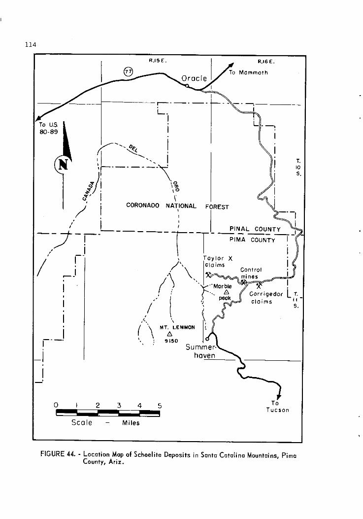
\ CORONADO NATIONAL FOREST
I
I Scale - Mi les
or Tucson
FIGURE 44. - Location Map of Scheelite Deposits in Santo Catolina Mountains, Pima County, Ariz.

L E G E N D Q
Scale - Feet
FIGURE 45. - Geologic Map of Taylor X Scheelite Deposit.

FIGURE 4 6 - Control Mines, Sonto Cotolino Mountains, Pimo County, Ariz.
P r o s p e c t o r s found copper around Marble Peak, probably about 1900. Phelps Dodge Corp. began t o e x p l o r e t h e copper d e p o s i t s i n 1910 and d i d exten- s i v e development work du r ing t h e nex t 3 years . The Geesman s h a f t was sunk and d r i f t i n g was done on t h e loo-, 200-, and 250-foot l e v e l s . I n 1937 t h e C a t a l i n a Conso l ida t ed Copper Co. l e a s e d t h e Geesman group and t h e ad jo in ing Da i ly p rope r ty . A 100-ton f l o t a t i o n p l a n t was b u i l t , and 18,000 t o n s of o r e , averaging 2.7 p e r c e n t copper , was mi l l ed . I n October 1939, C o n t r o l Mines, Inc . bought t h e m i l l and l e a s e d t h e Da i ly p rope r ty . I n May 1940, t h e company acqui red t h e Geesman p r o p e r t y from Phelps Dodge Corp. From October 1939 t o August 1942, product ion averaged between 1,500 and 2,000 t o n s of copper o r e p e r month. I n 1943, t h e p r o p e r t y a g a i n changed hands, becoming t h e Con t ro l Mines Co. T h i s company i s s a i d t o have produced a t approximate ly t h e same r a t e a s t h e p rev ious company u n t i l t h e middle of 1946, when t h e Government premium p l a n was d i scon t inued and t h e o p e r a t i o n was stopped. L a t e r Arizona Copper Mines, Inc . acqu i r ed t h e p r o p e r t y , and by 1951 had c o n s o l i d a t e d a number of cont iguous groups of mining c la ims. T h i s company r e t a i n s ownership of them today.
Product ion of t u n g s t e n o r e h a s been smal l . The g r e a t e s t product ion h a s come from t h e Cor r igedor c l a im, one of a group of s i x c la ims l o c a t e d by Newt'Wells i n 1942 o r 1943. The Cor r igedor l i e s about 3,000 f e e t e a s t of t h e o l d C a t a l i n a Consol ida ted m i l l s i t e . The group of c la ims was s o l d r e c e n t l y t o

Arizona Copper Mines, Inc . Newt Wells s o l d 100 t o n s of o r e c o n t a i n i n g 4 pe rcen t IN03 from t h e Cor r igedor .
. One t o n of s c h e e l i t e o r e c o n t a i n i n g 11 p e r c e n t WO3 was s o l d from t h e Geesman mine. The o r e was t a k e n from n e a r t h e su r f ace .
Ore d e p o s i t s i n t h i s a r e a occur i n a c o n t a c t metamorphic zone of a lmost cont inuous e x t e n t around Marble Peak. The t r a c e of t h e c o n t a c t i s a g r e a t oval some 7,000 f e e t from e a s t t o west and 4 ,500 f e e t from n o r t h t o south. I n t r u s i v e i n t o a sedimentary s e r i e s of l i m e s t o n e s and q u a r t z i t e s i s a mass of d i o r i t e . The i n t r u s i v e h a s formed a t a c t i t e zone, which i n g e n e r a l i s composed of g a r n e t , e p i d o t e , and q u a r t z , and which h a s a l t e r e d t h e l imes tone t o marble.
M i n e r a l i z a t i o n h a s been found a t many p o i n t s a long t h e c o n t a c t , and s i z e - a b l e o r e bod ie s have been developed and mined on t h e Geesman and D a i l y groups of claims. The o r e m i n e r a l s a r e c h a l c o p y r i t e w i th subord ina t e amounts of b o r n i t e and c h a l c o c i t e , and a minor amount of s c h e e l i t e .
S c h e e l i t e h a s been found on t h e t a c t i t e - m a r b l e c o n t a c t i n t h e Da i ly mine i n two smal l pockets , each e s t ima ted t o c o n t a i n l e s s t h a n 10 tons . Sporad ic . t r a c e s of s c h e e l i t e a r e found throughout t h e Geesman mine, b u t t h e on ly p l a c e s where s c h e e l i t e o r e could p o s s i b l y be mined a r e a long t h e t a c t i t e - m a r b l e con tac t i n t h e P.D. a d i t and on t h e 100-foot l e v e l wes t of t h e h o i s t i n g s h a f t . I n both of t h e s e l o c a l i t i e s t h e u l t r a v i o l e t lamp i n d i c a t e s t h e p re sence o f s c h e e l i t e wherever t h e c o n t a c t i s exposed, b u t t h e mine ra l i zed zone i s l e s s t han 2 f e e t wide i n most places.%/
S c h e e l i t e on t h e C o r r i g e d o r c la im o c c u r s i n q u a r t z i t e t h a t h a s been g r e a t l y a l t e r e d . The s t r a t u m of q u a r t z i t e c r o p s o u t f o r about 500 f e e t a long i t s e a s t e r l y s t r i k e . The u l t r a v i o l e t lamp shows s c h e e l i t e f o r abou t 250 f e e t of t h i s d i s t a n c e . Two sha l low s h a f t s have been sunk i n t o t h e q u a r t z i t e . The o re nea r t h e s u r f a c e i s a s much a s 3 f e e t wide, b u t narrows a t dep th . The re i s spa r se s c h e e l i t e a t a dep th of 30 f e e t .
I n 1955, t h e American Exp lo ra t ion 8 Mining Co. mapped and sampled t h e Daily and Geesman p r o p e r t i e s . With t h e pe rmis s ion of Arizona Copper Mines, Inc. , owners of t h e p r o p e r t y , t h e fo l lowing in fo rma t ion was a b s t r a c t e d from a g e o l o g i c a l r e p o r t by t h e American Exp lo ra t ion 8 Mining Co.
About s c h e e l i t e m i n e r a l i z a t i o n i n t h e D a i l y mine, t h e r e p o r t s t a t e s :
The l imes tone immediately o v e r l y i n g t h e t a c t i t e c o n t a i n s a l i t t l e s c h e e l i t e . The m i n e r a l i z a t i o n i s i r r e g u l a r and s p o t t y and t h e zone i s narrow, be ing about one f o o t wide.
3 P e t e r s o n , Nels P., and Creasey , S. C., Some Copper Depos i t s of t h e Old Hat Mining D i s t r i c t , Pima County, Ariz.: Geol . Survey Open F i l e Rept . , 1943.

Some s c h e e l i t e o c c u r s d i s semina ted through t h e t a c t i t e b u t t h e g rade i s i n g e n e r a l l e s s t han 0.2% WO3. L o c a l l y , sma l l pocke t s of s c h e e l i t e occur i n t h e narrow q u a r t z e p i d o t e ve ins .
Enough s c h e e l i t e showed i n t h e Geesman mine s o t h a t a s e p a r a t e s t u d y was made t h e r e . A s c h e e l i t e zone was found i n t h e Geesman No. 1 l e v e l t h a t was 200 f e e t long wi th an ave rage width o f 2.7 f e e t and an e s t i m a t e d g rade o f 1.4 pe rcen t WO3. I n t h e P.D. a d i t on t h e Geesman p r o p e r t y a s c h e e l i t e zone was found, a l s o 200 f e e t l ong , w i t h an ave rage width of 2.0 f e e t and a c o n t e n t of 1 pe rcen t WO3 wi th a mining width of 4 f e e t .
Sporad ic t r a c e s of s c h e e l i t e a r e found throughout t h e underground workings of t h e Geesman mine.
Two samples (14845 and 14846) were c u t from t h e m i l l t a i l i n g dump. Both samples a s sayed 0.01 p e r c e n t WOg.
Biq Buq Claims
The Big Bug group o f f o u r unpa ten ted c l a ims i s s i t u a t e d on t h e e a s t e r n s lope of P i e t y H i l l a t t h e s o u t h e a s t e r n e x t r e m i t y o f t h e San ta C a t a l i n a Mountains i n sec . 31, T. 1 2 S., R. 1 8 E. The a l t i t u d e i s approximate ly 4,000 f e e t . The c l a i m s l i e on S t a t e l and abou t 1 mi l e e a s t of t h e Coronado Na t iona l Fo res t boundary. To r each t h e c l a ims , f o l l o w t h e Redinqton road n o r t h e a s t e r l y f o r 27.6 miles from t h e c o r n e r o f Speedway and Wilmot Road i n Tucson t o a narrow b u l l d o z e r road t u r n i n g no r thwes t . Follow t h i s road 0 .1 m i l e t o t h e l o c a t i o n s h a f t on Big Bug No. 1 claim. About 10.6 m i l e s of t h i s road i s paved and t h e remainder i s a graded mountain road ( f i g . 47) .
T h i s p r o p e r t y was l o c a t e d i n 1944 by J. E. and H. A. Kinnison. Workings on t h e c l a i m s c o n s i s t o f a few sha l low p i t s and opencuts . There h a s been no production.
S c h e e l i t e o c c u r s n e a r a g a r n e t i z e d a r e a c l o s e t o a c o n t a c t between l ime- s tone and g n e i s s . The Tucson g e o l o g i c quadrang le ma& shows t h a t t h e l ime- s tone i s t h e Cambrian Abrigo format ion and t h a t t h e g n e i s s i s C a t a l i n a g n e i s s . There i s a sma l l exposure of Precambrian O r a c l e g n e i s s i c g r a n i t e a long t h e contac t . The l imes tone h a s been marble ized t o a g r e a t e x t e n t . The o r e o c c u r s s p o r a d i c a l l y i n a d i s c o n t i n u o u s zone w i t h a maximum width of 2 f e e t . The zone s t r i k e s no r thwes t , d i p s s t e e p l y n o r t h e a s t , and can be t r a c e d a long t h e s t r i k e f o r about 1 ,000 f e e t .
Assoc ia t ed w i t h t h e s c h e e l i t e a r e e p i d o t e , g a r n e t , w o l l a s t o n i t e , q u a r t z , and a very sma l l amount o f copper ca rbona te s .
Very l i t t l e work h a s been done on t h e p r o p e r t y . The re i s a s h a f t abou t 15 f e e t deep and few shal low p r o s p e c t ho le s . An a d i t about 10 f e e t long h a s
Moore, B. N . , Tolman, C. F., and O t h e r s , Geology of t h e Tucson Quadrangle , Arizona: Geol. Survey Open F i l e Rept . , Arizona Bureau o f Mines, 1949.

GORONADO NATIONAL
I L.
FOREST
FIGURE 47. - Location Map of Big Bug Prospect, Santa Catalina Mountains, Pimo County, Ariz.
been driven beside a local garnetized zone. Most of the area is covered with alluvium, and only float can be seen along the contact.
Santa Cruz County
Calabasas Tungsten
J. M. ~i1138/ first reported the occurrences of wolframite and scheelite in the Calabasas area.
The tungsten occurs in the ~ ~ 1 / 4 sec. 18 and the ~ ~ 1 / 4 sec. 7, T. 23 S., R. 14 E. It lies on the Baca Float No. 3 land grant and is owned by Baca Float, Inc. The old workings may be reached by traveling north from Nogales
L on U.S. Highway 89 for 4 miles to where the old Tucson-Nogales highway leaves the new road. Follow the old road 2.4 miles to the junction of Santa Cruz River road and the old Tucson-Nogales highway. Follow the river road easterly
Hill, J. M., Note on the Occurrence of Tungsten Minerals near Calabasas, Ariz.: Geol. Survey Bull. 430, 1910, pp. 164-166.

0.7 mile t o a dim t r a i l on t h e t o p of a r idge. Follow t h i s dim t r a i l north- e r l y 0.5 mile t o a fence on t h e Baca F loa t boundary; then fol low t h e dim t r a i l on f o o t a d i s t a n c e of 0.25 mi le t o t h e old workings ( f i g . 48).
According t o H i l l , t h i s d e p o s i t of tungs ten o r e has been known s ince 1906. He s t a t e s t h a t up t o 1909 about 1,500 pounds of o r e conta ining 50 percent WO3 had been mined and shipped by a man amed Reagan. Some production 2 was made i n 1913, according t o Eldred ~ i l s o n . 3 9 The proper ty was worked i n 1937 and 1938 by William Lof tus , who so ld 66 pounds of concen t ra tes during t h i s time. I t has been repor ted t h a t H. B. Imus had t h e proper ty i n 1940, but apparent ly no o r e has been produced s i n c e 1938.
The following geology i s from t h e a r t i c l e by H i l l :
Th i s a r e a , between Nogales Wash and Santa Cruz River, i s made up of coarse-grained l ight-gray g r a n o d i o r i t e in t ruded by d i k e s of a p l i t e and lamprophyre. Cut t ing t h e s e rocks a r e ve ins of bonded, comb-textured quar tz wi th wolframite, minor s c h e e l i t e , and sparse c a l c i t e . There a r e many veins , a l l s t r i k i n g N. 25O W. and essen- t i a l l y v e r t i c a l , b u t apparen t ly most of them a r e barren o r of low grade.
Three of t h e q u a r t z v e i n s have been worked f o r tungsten content . The shallow s h a f t s and p i t s have caved and a r e now i n a c c e s s i b l e , but remnants of t h e ore can be found. Lof tus deepened one of t h e s h a f t s sunk by Reagan t o about 60 f e e t . Although not caved, it i s i n a c c e s s i b l e .
N a r r o A a n d s of t h e reddish-brown wolframite a r e f a i r l y continuous through t h e quar tz veins. Where o r e has been removed t h e ve ins average about 4 inches i n width. No pockets a r e v i s i b l e today. However, H i l l s t a t e d t h a t t h e l a r g e s t pocket seen was about 3 by 4 f e e t i n a 6-inch vein.
S c h e e l i t e occurs a s t i n y c r y s t a l s a ssoc ia ted with t h e wolframite.
Martha Washington Claim
The Martha Washington c la im i s one of a group of 160 claims owned by Coronado Mines, Inc. , which l i e s between t h e Santa Cruz River and t h e c r e s t of t h e Patagonia Mountains near t h e Washington Camp road. The Martha Washington claim i s i n t h e southwestern corner of t h e group. I t i s i n t h e N ~ 1 / 4 sec. 12, T. 24 S., R. 15 E. The c la im may be reached by road from Nogales. Follow S t a t e Highway 82 f o r 5.2 mi les t o a road fo rk immediately e a s t of t h e Santa Cruz River bridge. Take t h e r i g h t fo rk toward Washington Camp f o r a d i s t a n c e of 7.1 mi les t o a dim t r a i l going southeast . The t r a i l ends about 0.1 mile from the r o a d ' a t an o ld campsite. The workings a r e s i t u a t e d on t o p of a low peak a few hundred yards southwest of t h e old campsite ( f i g . 48).
Wilson, E. D., Tungsten Deposits of Arizona: Arizona Bureau of Mines Bull. 148, 1941, p. 50.

BAGA /- - I-
FLOAT <.- / \/-
lobasos NO. 3
Mexico R.15 E.
j i i i G O R O N A D O
.- 1 i i NATIONAL n io
i i FOREST
- -
0 I 2 3 4 5 INDEX OF DEPOSITS
Scale - miles I. Calabasas tungsten 2. Martha Washington claim
FIGURE 48 - Location Mop of Tungsten Deposits, Sonia Cruz County, Ariz.
The h i s t o r y of t h i s sma l l s c h e e l i t e o c c u r r e n c e i s vague. The c la im was l o c a t e d b e f o r e t h e F i r s t World War by a man known s imply a s J u l i o . Sometime i n t h e l a t e 1930's o r e a r l y 1940 ' s Hugo M i l l e r of Nogales, A r i z . , purchased t h e c l a i m from J u l i o , and l a t e r s o l d it. The d a t e t h a t Coronado Mines, I n c . acqu i r ed t h e c l a i m i s n o t known. J u l i o mined a few u n i t s of s c h e e l i t e , b u t , s o f a r a s i s known, no p roduc t ion h a s been made s i n c e t h a t t ime .
There a r e an a d i t abou t 30 f e e t l ong w i t h a winze approximate ly 25 f e e t deep and a few sha l low opencu t s and p i t s .
Sporad ic s c h e e l i t e , molybdeni te , and copper ca rbona te s occu r i n pockets i n q u a r t z and f a u l t gouge c u t t i n g a coa r se -g ra ined g r a n i t e . The d e p o s i t s t r i k e s g e n e r a l l y N. 30' W. and d i p s 34' NE. S c h e e l i t e formed n e a r a s h e a r a long which t h e r e appea r s t o have been some movement. The s h e a r s t r i k e s N. 73O E. and d i p s 78O NW. S c h e e l i t e f l o a t from s p o r a d i c pocke t s may be lamped a t n i g h t ove r a c o n s i d e r a b l e d i s t a n c e . The pocke t s t h a t may be seen a r e v e r y smal l .
Red Mountain Claims
A t u n g s t e n d e p o s i t i n S a n t a Cruz County, no t v i s i t e d by t h e w r i t e r b u t r e p o r t e d by ~ i l s o n , 4 0 / i s i n c l u d e d i n t h i s r e p o r t f o r h i s t o r i c a l va lue . Wilson ' s r e p o r t fo l lows:
The Red Mountain c l a i m s , h e l d by t h e Kino Copper Company, i n c l u d e t h e s o u t h e a s t e r n s i d e of G u a j o l o t e F l a t .
Here, g r a n i t i c rock i s invaded by a s t o c k o r p i p e of a c i d porphyry abou t 1,200 f e e t i n d i ame te r . The sou the rn b o r d e r of t h i s mass shows n o r t h e r l y v e r t i c a l f r a c t u r i n g and l o c a l i n t e n s e s e r i c i t i c a l t e r a t i o n . A s e r i c i t e zone a b o u t 5 f e e t wide c o n t a i n s i r r e g u l a r p a r t i c l e s and masses, u p t o s e v e r a l i n c h e s i n d i ame te r , of a brown- i s h t u n g s t e n minera l of unknown i d e n t i t y . The a d j a c e n t w a l l rock a l s o c a r r i e s some p a r t i c l e s o f a s i m i l a r t u n g s t e n mine ra l . Oxidized molybdenum compounds a r e abundant i n t h i s m i n e r a l i z e d a r e a .
@ Work c i t e d i n f o o t n o t e 39 (p. 1 2 0 ) , p. 50.
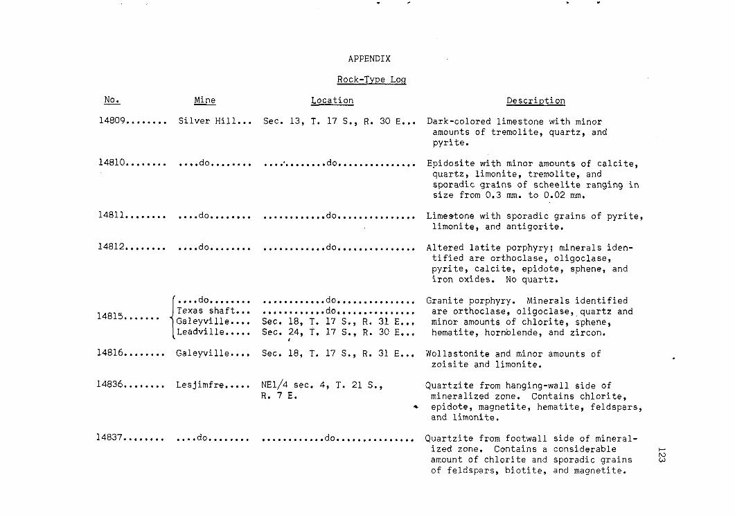
NO. - 14809........
Mine - Silver Hill...
.... do........
.... do........
.... do........
Texas shaft 14815....... Galeyville.
14816........ Galeyville.
14836........ Lesjimfre. ....
14837........ .... do........
APPENDIX
Rock-Type Loq
Location
Sec. 13, T. 17 S., R. 30 E...
...:........ do...............
............ do...............
............ do...............
............ do... ............ do... Sec. 18, T. 17 S. Sec. 24, T. 17 S.
, ............ ............ . R. 31 E. .. , R. 30 E...
Sec. 18, T. 17 S.
~ ~ 1 / 4 sec. 4, T. 21 S., R. 7 E.
Description
Dark-colored limestone with minor amounts of tremolite, quartz, and pyrite.
Epidosite with minor amounts of calcite, quartz, limonite, tremolite, and sporadic grains of scheelite ranging in size from 0.3 mm. to 0.02 mm.
Limestone with sporadic grains of pyrite, limonite, and antigorite.
Altered latite porphyry; minerals iden- tified are orthoclase, oligoclase, pyrite, calcite, epidote, sphene, and iron oxides. No quartz.
Granite porphyry. Minerals identified are orthoclase, oligoclase,,quartz and minor amounts of chlorite, sphene, hematite, hornblende, and zircon.
Wollastonite and minor amounts of zoisite and limonite.
Quartzite from hanging-wall side of mineralized zone. Contains chlorite. epidote, magnetite, hematite, feldspars, and limonite.
............ do............... Quartzite from footwall side of mineral- ized zone. Contains a considerable C.
N amount of chlorite and sporadic grains w of feldspars, biotite, and magnetite.

No. - Mine - ~ocation
14839........ Serasio....... Sec. 25, T. 17 S., R. 12 E... .
15033........ 15035........ Calvert i ...... Sec. 13, T. 17 S., R. 6 E.... 15037.. ( summary). 15050........
15033........ Nelson's ............ do............... Pride No. 2.
Description - N
Altered metamorphic rock composed predom- P
minantly of garnet with some calcite, epidote, quartz, iron oxides, chrys- ocolla, malachite, and sporadic grains of yellow to orange fluorescent schee- lite. Spectroscopic tests on a panned concentrate showed lines for tungsten and molybdenum.
Feldspathic quartzite. The original rocks were probably Arkosic sandstones containing calcite as the cementing material Different degrees of meta- morphism are represented by the samples. as revealed by the accessory minerals and texture parallelism. The amount of metasomatism or replacement from igneous sources is difficult to ascertain.
From prospect pits. Mineral assemblage includes quartz, orthoclase, andradite, oligoclase, and small amounts of ilmen- ite, epidote, zircon, and manganese oxide stains. Both the epidote and manganese oxide stains occur on fracture planes as coatings and represent alter- ation derived from the feldspathic quartzite. The texture of the rock shows considerable granulation in the quartz and feldspar grains. Some flow- age has occurred between the quartz and feldspar grains, with the garnet occur- ring in random clusters. The sample is very dense and compact, leaving very little space for tungsten mineralization.

15035........ Nelson's Pride No. 1.
15037........ Terry Marie No. 1.
15050........ ..... do.......
15039........ Southside.....
Sec. 13, T. 17 S., R. 6 E.... Similar in composition to that of sample 15033. Texture studies show more flow- age and parallelism among the minerals. The andradite occurs in irregular bands.
............ do............... Composed of quartz and orthoclase with minor amounts of chlorite, hornblende, and ilmenite, and sporadic grains of epidote, zircon, and andradite. There is definite banding and parallelism of the mineral grains. Studies of thin sections show some large, elongated quartzite pebbles in a fine-grained matrix of quartz, orthoclase, horn- blende, and chlorite. The flowage pat- tern of the matrix-type material around the quartzite pebbles is observed clearly under the microscope.
do............... Quartz, orthoclase, grossularite, and ............ sporadic inclusions of epidote, zircon, and scheelite. The texture of the material shows only a minimum of flowage in the quartz and orthoclase; the gros- sularite is in random clusters. The scheelite is adjacent to some of the grossularite clusters.
... do............... Feldspathic quartzite. Minerals identi- fied were predominantly quartz, ortho- clase, and minor amounts of oligoclase, epidote, andradite, zircon, ilmenite, and manganese oxide stains. Examination of a thin section under the microscope showed a granular texture and several areas where the quartz had been recrys- tallized. It appears that the original arkosic sandstone also contained some b-
h,
small pebbles of quartz. 5

NO. - Mine - Location Description N
15043A....... Bib Banana.... Sec. 32, T. 17 S., R. 7 E.... Quartzite from footwall side of the 01
deposit. The quartz particles were cemented by a fine-grained intergrowth of sericite and quartz. The quartzite showed different shades of brown coloring which represented the original bedding planes of the sandstone.
15043B....... .... do........ ............ do............... Hornfels from the hanging-wall side of the deposit. Composed predominantly of quartz and hornblende with some feld- spars, chlorite, biotite, and iron oxides. Texture studies showed a dense, sugary-grained intergrowth of fine- grained quartz, hornblende, chlorite, and biotite in which remnant, coarse grains of oligoclase, quartz, and ortho- clase occurred.
15044........ .... do........ ............ do............... Slightly metamorphosed rhyolite porphyry taken 900 feet from the portal of the main adit. Identified minerals were orthoclase, oligoclase, quartz, horn- blfnde, chlorite, hematite, magnetite, ilmenite, and epidote. Some calcite, clay, and hematite occurred on fracture planes as thin coatings. About one-half of the sample was composed of quartz and feldspar phenocrysts with sporadic black grains identified as hematite. Studies of the matrix portion showed that it was composed of a fine-grained intergrowth of feldspars, quartz, hornblende, and chlorite. A few small quartz veinlets crosscut both the phenocrysts and matrix. Texture studies revealed that the sample had been subjected to a slight amount of pressure. Many of the

15044........ Big Banana.... Sec. 32, T. 17 S., R. 7 E.... phenocrysts were granulated and existed in separated, recemented fragments. Contacts between the phenocrysts and matrix were rounded and sutured, which clearly indicated the influence of metamorphic conditions.
15045A....... .... do........ ............ do............... Quartzite, in which sporadic grains of hornblende, chlorite, and iron oxide occurred. A thin section also contained one small calcite veinlet.
15045B....... .... do........ ............ do............... Arkosic quartzite. Texture showed flow- age and parallelism among the quartz and feldspars.
15048........ Rushbey....... Sec. 19, T. 17 S., R. 7 E.... Quartzite, in which minor amounts of hornblende, orthoclase, zircon, chlorite, and iron oxides occurred. Texture studies showed parallelism and some recrystallization of the quartz grains. The hornblende particles were altered to chlorite in some areas.
15049........ Giant......... Secs. 19 8 20, T. 20 S., Porous quartzite, in which considerable R. 7 E. manganese-bearing zoisite and molyb-
denum-bearing scheelite occurred. The quartz grains have been granulated and recrystallized in most of the thin sec- tions observed under the microscope. It is believed that the original feld- spars in the quartzite have been altered to zoisite by contact-metamorphic conditions.

No. Mine - - - Location Description N m
15115A....... Giant......... Secs. 24 & 25, T. 20 S., Two samples from vein material classi- R. 6 E. fied as quartzite in which zoisite,
calcite, and sporadic grains of molyb- denum-bearing scheelite occurred. The texture was about the same as that in sample 15049.
15115B....... .... do........ ............ do............... Quartzite from the footwall. Contains appreciable amount of epidote. Small veinlets of quartz observed throughout the sample. Adjacent to the quartz veinlets were sporadic, acicular crys- tals of altered actinolite. A thin section showed a uniform intergrowth pattern between the quartz and epidote. A large portion of the quartz had been recrystallized.
15115C....... .... do........ ............ do............... A black, micaceous sample from the foot- wall, composed of about equal amounts of quartz and chlorite together with some ilmenite, magnetite, and zircon. The chlorite appeared to have been formed as a result of the alteration of biotite. The texture and mineral composition of this rock indicates that the original material was a sandstone which contained larger amounts of clay and iron oxides. The sample was classi- fied as hornfels.
15101........ Jezebel....... Sec. 19, T. 17 S., R. 7 E.... Quartzite, in which some fragments were high in epidote and others contained appreciable chlorite. Minor mineral constituents were andesine, biotite, ilmenite, zircon, and iron oxide stains. A large portion of the chlorite appeared to have been formed as a result

15101........ Jezebel....... Sec. 19, T. 17 S., R. 7 E.... of alteration of biotite. Texture and mineral composition revealed that the original rock was a sandstone containing some andesine and calcareous clay. The source of contact metamorphic conditions appears to have been near these rock samples. The large amount of granula- tion and recrystallization observed in
t the quartz, plus the formation of epi-
15106........ dote, proves this observation. 15107........ 15109........ Yellow Star... Sec. 19, T. 17 S., R. 6 E.... All six samples are feldspathic quartzite 15111........ in various phases. The samples con- 15 1_12. . . . . . . . tained grossularite and sporadic grains 15117........ of epidote, zircon, and scheelite, and
were cut by milky-white veins of almost pure orthoclase which ranged in size from three-quarters of an inch in diameter to hairline veinlets. Small veinlets of quartz were also observed. Both the orthoclase and the quartz in these veins and veinlets were introduced into quartzite and represent an igneous source. A heavy mineral concentrate prkpared from sample 15106, which showed a typical occurrence of the garnet, was examined spectroscopically. Results of tests showed strong spectral lines for calcium, aluminum, and silicon, together with weak lines for manganese, iron, and titanium.

Assay NO . 14804 ....... 14805 ....... 14806 ....... 14807 ....... 14808 ....... 14813 ....... 14814 ....... 14817 ....... 14818 ....... 14819 ....... 14820 ....... 14821 ....... 14822 ....... 14823 ....... 14824 ....... 14825 ....... 14826 ....... 14827 ....... 14828 ....... 14829 ....... 14830 ....... 14832 ....... 14833 ....... 14834 ....... 14835 ....... 14840 ....... 14841 ....... 14842 ....... 14843 ....... 14844 ....... 14845 ....... 14846 ....... 14847 .......
Mine . Si lve r H i l l ............. .... do .................. .... do .................. .... do .................. .... do .................. Galeyvil le .............. .... do .................. King-Ainsworth .......... Chiricahua .............. Si lve r S t r i k e ........... .... do .................. Si lve r Bel l ............. H i l l Top ................ Si lve r H i l l ............. .... do .................. .... do .................. .... do .................. Columbia ................ .... do .................. Ram ..................... Republic m i l l ........... .... do .................. .... do .................. Lesjimfre ............... Mineral H i l l m i l l ....... .... do .................. .... do .................. .... do .................. San Xavier m i l l ......... Control m i l l ............ .... do .................. C 8 H ...................
Assay Log
Length of cut. Location f e e t
Sec . 13. T . 17 S.. R . 30 E ..... 36 ............ do ................. 17 ............ do ................. 7.5 ............ do ................. 88 ............ do ................. 43 Sec . 18. T . 17 S.. R . 31 E ..... 22 ............ do ................. 27 Sec . 5. T . 17 S.. R . 31 E ...... Grab sample ..... Sec . 14. T . 17 S.. R . 30 E ..... 4 Sec . 28. T . 14 S.. R . 28 E ..... 6 ............ do ................. 5 ............ do ................. 0.3 Sec . 29. T . 14 S.. R . 28 E ..... 3.5 Sec . 5. T . 17 S.. R . 30 E ...... 6.3 Sec . 13. T . 17 S.. R . 30 E ..... 3 ............ do ................. 3.5 ............ do ................. 2.3 ............ do ................. 3.5 ............ do ................. 12 ............ do ................. Grab sample ..... Sec . 21. T . 14 S.. R . 28 E ..... 3.5 Sec . 25. T . 15 S.. R . 22 E ..... 10- by 14-in . diam . ............ do ........................ do .......... ............ do ........................ do .......... ~ ~ 1 / 4 Sec . 4. T . 21 S.,
R . 7 E ....................... 3.7 Sec . 35.'T . 16 S.. R . 12 E ..... 10- by 4.in . diam .. ............ do ........................ do .......... ............ do ........................ do .......... ............ do ........................ do .......... Sec . 13. T . 17 S.. R . 13 E ..... 6- by 4.in . diam ... Sec . 17 . T . 11 S.. R . 16 E ..... 10
do 10- by 4.in diam ............ ................. . .. Sec . 21. T . 17 S.. R . 16 E ..... Grab .........
- 0 0
WO3 percent
0.04 .02 .04 .02 .03 .17 .01
1.70 .06 .04 .14
2.05 .09 .23 .04 .14 .18 .89 .13 .18 .79 . 064 .142 . 067

C 8 H .................. .... do ................. Big Banana .............
.... do ................. C a l v e r t ................ .... do ................. Souths ide .............. Cable and Gajewski ..... Rushbey ................ Independence No . 2 ..... .... do ................. Gian t .................. J e z e b e l ................ .... do ................. Yellow S t a r ............ .... do ................. .... do ................. .... do ................. ............ L a s t Chance Giant ..................
~ u a n i t a Np; 9 .......... Lone Eagle ............. San Juan ...............
Sec . 21. T . 17 S.. R . 16 E ..... ............ do ................. Sec . 32. T . 17 S.. R . 7 E ...... ............ do ................. ............ do ................. ............ do ................. ............ do ................. Sec . 13. T . 17 S.. R . 6 E ...... ............ do ................. ............ do ................. ............ 4 0 ................. Sec . 24. T . 17 S.. R . 6 E ...... Sec . 19. T . 17 S.. R . 7 E ...... Sec . 24. T . 17 S.. R . 6 E ...... ............ do ................. Sec . 19. T . 30 S.. R . 7 E ...... Sec . 19. T . 17 S.. R . 7 E ...... ............ do ................. Sec . 24. T . 17 S.. R . 6 E ...... ............ do ................. ............ do ................. ............ do ................. Sec . 30. T . 17 S.. R . 7 E ...... Sec . 19 8 30. T . 20 S.,
R . 7 E ....................... Sec. 24 8 25. T . 20 S.,
R . 6 E ....................... Sec . 30. T . 17 S.. R . 7 E ...... Sec . 1. T . 17 S.. R . 6 E ....... Sec . 30. T . 17 S.. R . 7 E ......
~ ~
Grab ........... ....... do ........... ....... do ........... ....... do ...........
. . ....... ....... ............. . 15128 Lone Eagle Sec 1. T 17 S.. R 6 E 4

Mines Checked With Ul t rav io le t Lamp Which Showed No Evidence of Scheel i te Mineralization
Paradise claim................................
Martin patented claim.........................
Harr i s mine...................................
Doran mine....................................
Ajax mine.....................................
El Tigre mine.................................
Name unknown..................................
King of Lead..................................
Sec. 19, T. 17 S., R. 31 E.
............ Do.............
Sec. 32, T. 16 S., R. 31 E.
Sec. 29, T. 16 S., R. 31 E.
Sec. 30, T. 16 S., R. 31 E.
Approximate sec. 28, T. 17 S., R. 30 E., unsurveyed.
Secs. 1 8 12, T. 15 S., R. 28 E.
Sec. 18, T. 16 S., R. 30 E.