qualifier - province of manitoba | manitoba conservation ... · web viewrelevant treasury board...
TRANSCRIPT
Version 03/14/01
Contents
I Treasury Board Policy And Cost Recovery..............................1
A. Overview of federal cost recovery...................................1
B. The policy according to the Federal Treasury Board.......4
C. Clarification of issues.....................................................10
D. Key concepts for implementation...................................13
E. Provincial cost recovery policies....................................14
II Canadian Geospatial Data Agencies.....................................17
A. Overview........................................................................17
B. Federal agencies...........................................................19
C. Provincial agencies........................................................30
D. Municipal agencies........................................................44
E. The economics of Canadian data agencies...................49
F. Summary of data policy and practices...........................55
G. Economic and social impacts of geospatial data dissemination.................................................................58
III Canadian Client Feedback....................................................69
A. The client feedback process..........................................69
B. Overview of the comments from clients.........................70
C. Demographics of respondents.......................................71
D. Use of digital data..........................................................73
kpmg 1
Version 03/14/01
E. Geospatial data delivery................................................77
F. Price of data...................................................................79
G. Client comments on geospatial data policies.................83
H. Impact of policies...........................................................85
I. Suggested changes by Canadian data clients...............86
J. Impact on User Community...........................................89
IV International Comparisons Of Data Policies And Practices...93
A. Overview........................................................................93
B. Summary of similarities and differences........................94
C. US data agencies..........................................................97
D. US data policies, practices and impacts......................101
E. Australian agencies.....................................................108
F. Australian policies, practices, and impacts..................111
G. New Zealand................................................................116
H. International client comments......................................117
V Summary And Recommendations.......................................127
A. Pricing strategy decision factors..................................127
B. Current pricing practices..............................................128
C. Current licensing and royalty strategies.......................129
D. Privacy issues..............................................................130
E. Unintended outcomes of current approaches..............130
F. Optimal policy directions within a changing environment132
G. Proposed recommendations........................................134
H. Implications and corollary actions................................138
kpmg 2

Version 03/14/01
I. Other issues.................................................................142
Glossary of Terms.............................................................................144
A. Definitions and Terms..................................................144
B. Acronyms.....................................................................147
Appendices
Appendix A—USGS Policy Statements on Pricing
Appendix B—Summary of US Data Agency Responses
Appendix C—Data Availability and a List of US Respondents Web Sites
Appendix D—Policy Overview, Cost Recovery and Prices—USA Respondents
Appendix E—Mandates of the Australian Respondents
Appendix F—Data Availability and a List of Australian Respondents Web Sites
Appendix G—Policy Overview, Cost Recovery and Prices—Australian Respondents
Appendix H—Submission to the (Australian) Productivity Commission Inquiry into Cost Recover
Appendix I—Participating Organizations
Appendix J—Data Agency Questionnaires
Appendix K—Data Client Surveys
kpmg 3iii

Version 03/14/01
I
Treasury Board Policy And Cost Recovery
Of key concern to the issue of digital geospatial data policies and practices is the pricing of data based on the notion of cost recovery. This chapter provides an overview and critical review of the current federal cost recovery policy’s rational, weaknesses and implementation issues. It also touches on some of the diverse provincial policies used.
A. Overview of federal cost recovery
In Canada, cost recovery is a $3.7 billion dollar Federal Government policy initiative that requires government departments to consider charging appropriate fees for qualifying services. The policy is far ranging, covering issues such as: when fees are appropriate; for which sort of services fees are appropriate; the types of fees allowed; the authorities required; general guidance on the relationship of fees to costs; and, consultation and monitoring.1
Cost recovery is a means of transferring some or all of the costs of a government activity from the general taxpayer to those who more directly benefit from or who “trigger” that special activity.2
When the Treasury Board (TB) introduced cost recovery as a policy initiative, it noted that cost recovery “cannot be used simply as a means of generating revenue to meet the funding requirements of a department or agency.”3 Accordingly, the TB Cost Recovery Policy is intended to result in improvements to the provision of government services and more equitably utilized public resources. Cost recovery attempts to achieve these objectives by:
Promoting an equitable approach to financing government services by fairly charging clients or beneficiaries who benefit from services.
1 Cost Recovery in the Therapeutic Products Programme: An Overview, TPP, Health Canada, July 1999.
2 Ibid.
3 Cost Recovery and Charging Policy, Treasury Board Secretariat, pg. 1, and interview notes with David Hum, Principal Advisor, Cost Recovery Policy Division, Treasury Board Secretariat.
kpmg 1

Version 03/14/01
Promoting more efficient use of government services by reducing frivolous demand often associated with free services.
Facilitating possible improvements in the delivery of services by introducing more business-like and client-oriented practices in the supply of government services.
1. The rationale of cost recovery
In 1993, the Federal Government aggressively began its deficit reduction efforts, through the Program Review exercise. One of the purposes of cost recovery is to help departments achieve their mandates by assisting them to more efficiently use finite resources. The TB Policy states that “the economic rationale for levying user charges is to improve the efficiency” of program delivery and to achieve a more equitable use of limited public resources”.4 This means applying user fees to rationalize the supply and demand of a departmental service and charging users for consuming a government activity when the accrued benefits are beyond those enjoyed by the average citizen.
Cost recovery is more than just a means to raise revenue. It is a management tool that introduces market forces to make government more efficient by disciplining the supply and demand of public services. It is reasoned that by having stakeholders pay for certain government services, they will become more conscientious consumers. Similarly, by having departments charge for their services and behave in a more business like manner, the departments will become more cost conscious. This discipline will reduce frivolous consumption and waste. However, it is noted that the environment in which government programs operate does not always allow for the operational flexibility that is required for a truly “business-like” approach for the delivery of government services.
2. Challenges of cost recovery
A principal challenge facing many departments is a lack of clarity in implementing key cost recovery practices. Inconsistencies in cost recovery practices is not unique to geospatial data. In a recent study of three cost recovery programs, the Office of the Auditor General (OAG) noted that the programs reviewed in Agriculture Canada did not have a structured framework or clear criteria for defining public and private benefits or other cost recovery terms.5 Even as early as 1997, the OAG
4 Cost Recovery and Charging Policy, Treasury Board Secretariat 1997 pg. 1.
5 Auditor General of Canada, 1999 Report of the Auditor General, Chapter 11, Agriculture Portfolio User Charges.
kpmg 2

Version 03/14/01
“found that government accounting systems are typically not designed to provide costing information needed to justify the levels of user fees charged.”6
In addition, deciding upon which activities to charge for and how to set the fees is partly dependent upon the thorny concept of public versus private goods and benefits. This issue of what constitutes a public good, for example geospatial data collected by taxpayer money, versus a good that benefits a select entity, for example data sets used by a company to more effectively target its services, requires careful examination from all perspectives. Unfortunately, the TB policy is not very explicit on this front.
Where Does the Buck Stop? , a recent report by the Alliance of Manufacturers and Exporters (now called Canadian Manufacturers and Exporters or CME) succinctly tables a number of policy concerns facing cost recovery in the Federal Government.7 This report (referred to as the Blair Report) provides a comprehensive review of the concerns that a number of industry organizations have with cost recovery programs. A number of the concerns expressed in the Report are similar to those that were brought to our attention in the interviews and surveys of geospatial data agencies and clients. Below are some of the key policy concerns that are raised in the report.
The Blair Report contends that the theorized policy goals of cost recovery programs tend to be inconsistent with reality. Cost recovery is intended to foster greater equity, efficiency and better business practices in government. Instead, it can have, and has had, the opposite effect. The consequences for businesses are higher costs, lower research and development investments and threatened marginal products. The results for consumers are negative: higher prices and reduced products and services. The overall economic consequences, according to this report, are fewer jobs (23,000), reduced economic output by almost $2.6 billion and a lower gross domestic product (GDP) by nearly $1.4 billion.
The apparent failure of cost recovery to meet its targeted goals has led AMEC and others to call for an immediate moratorium on fees, a greater accountability on the part of central agencies and departments, a revamping of policies to achieve truer equity and a review of existing fees by an impartial third party.
The Inter-Agency Committee on Geomatics reports that cost recovery “…is in conflict with encouraging the broad use of spatially referenced data…” and proposes that to ensure data capture continues, “Users should pay a fee that
6 Auditor General of Canada, 1997 Report of the Auditor General, “Matters of Special Importance”
7 The Blair Consulting Group & Canadian Manufacturers and Exporters, Where Does the Buck Stop?, (Quebec), January 1999.
kpmg 3

Version 03/14/01
recovers the cost of distribution for data collected by government for government use”.8 The Committee suggests that data clients should “pay a fee for service for any specialized data collection or manipulation”.
In addition, a recent comprehensive report from the Standing Committee on Finance regarding cost recovery noted “growing concerns surrounding the government’s cost-recovery program and the manner in which it is being followed”.9 The Committee points to a number of challenges of the current policy in practice, ranging from inconsistent and varied definitions of public/private benefits and business impacts, to assorted dispute resolution processes. The report mentions how the implementation of cost recovery has major implications such as limiting access to innovation and products, and further states: “The effects of such charges are often disproportionately borne by small and medium-sized enterprises (SMEs), the growth engines of the Canadian economy”. The Standing Committee is interested in understanding how well user charges approximate efficient pricing and whether cost recovery has resulted in underfunding of cost recovery programs and overfunding of others. Among other proposals, it recommends more centralized guidance, stricter guidelines and uniform standards in user fee implementation, as well as information regarding user charge formulas, revenues and performance measures be made readily available.
B. The policy according to the Federal Treasury Board
In our analysis of the issue of public and private benefits, we take the Federal Treasury Board Policy as a given, however written Treasury Board Policy is silent or imprecise in certain areas. In some cases, discussions with the representatives of the Cost Recovery group at the Treasury Board Secretariat have clarified the relevant issues; in other cases, where necessary, we have made assumptions that we believe to be consistent with the rest of the relevant policy and its rationale. Relevant Treasury Board Policy is contained in two documents:
Cost Recovery and Charging Policy (Ottawa: Treasury Board of Canada Secretariat), 1997.
User Charging in the Federal Government—A Background Document, Prepared by Bird and Tsiopolous on behalf of the Treasury Board of Canada Secretariat, 1996
8 Inter-Agency Committee on Geomatics (IACG), Working Group on Coordination and Cooperation Report, January 1996.
9 Parliamentary Standing Committee on Finance, Challenge for Change—A Study of Cost Recovery, June 2000.
kpmg 4

Version 03/14/01
The Treasury Board Cost Recovery and Charging Policy references the background paper with the statement that “…the paper is intended to contribute to a better understanding of user fees and improved communications between departments and their clients”. Treasury Board Secretariat officials have also referred us to it as a source of clarification of the issues of public and private benefits.
1. Excerpts from the cost recovery and charging policy
The relevant portions of the Treasury Board Policy document, as they relate to public and private benefits, are described below. The Policy Statement reads in part “It is government policy to implement user charges for services that provide identifiable recipients with direct benefits beyond those received by the general public…”.
Among the aims cited are:
“To promote the efficient allocation of resources (i.e., to eliminate the excess demand that often exists with “free goods”, by subjecting programs to a market test of supply and demand)”; and,
“To promote an equitable approach to financing government programs, mandatory or otherwise, by fairly charging clients or beneficiaries who benefit from services beyond those enjoyed by the general public…”.
Sub-section (b) (Implementation Requirements) reads in part:
“Departments and agencies must follow appropriate costing and pricing practices…When there is a mix of public and private benefits, fees should be lower than full cost. Prices should be cost-based for goods, regulatory, and optional services”.
There is a requirement in the policy for departments to… “conduct periodic reviews to ensure user charge policy requirements are being met”. Such reviews should also address “whether fees should be increased or decreased where… the mix of public and private benefits has changed…”.
Reference note 1 to the Policy contains a discussion of public and private benefits. It says in part; “Departments and agencies must work with their clients to determine an appropriate allocation of public and private benefits”. This is followed by a discussion of public and private goods. It is not explicit in the reference note as to whether a private benefit is the same as a private good. For example, “disease control” is cited as an example of a government activity close to the “public” end of the spectrum, or range, between public and private goods. A passport could likewise be placed nearer the private goods end of this continuum.
kpmg 5
Version 03/14/01
There is a series of questions and answers attached to the Policy. The response to Question 8 states in part that: “Getting government right has focused attention on who receives benefits from government activities and whether it is reasonable for Canadians in general to continue to pay the full cost in cases where direct benefits accrue to specific individuals or organizations”. As well… “there will be a link between the fee charged and the cost of the good or service…” Finally, “Charges also help determine the proper scale of delivery by applying a market test of underlying demand, thus tending to eliminate the overuse that often exists with “free services”.
Interestingly, question 14 reads: “Why can you not be more specific with respect to the identification of private benefits?”. The answer is: “This is not an area where there are any easy answers. The reference notes in the policy provide some guidance in this area. The private element is clear when there are direct benefits conferred with respect to marketability, but there are other situations where the market activity imposes public risks and the costs of mitigating those risks should be borne by those profiting from the activity rather than the general taxpayer.” The dynamic nature in which geospatial data are used in Canada prevents a clear conclusion from this unclear answer.
2. Excerpts from the Bird-Tsiopolous Paper
The Bird-Tsiopolous Paper expands on a number of issues related to user charging. A number of excerpts and summaries from those parts of the document that relate to public and private benefits are provided below.10
The background document focuses on two principal purposes:
To present the rationale for user charges.
To set out general guidelines on how to determine where charges should be imposed, and what those charges should be.
Chapter 2 is entitled “Why Charge for Public Services?”, and states that, “the basic principle underlying this paper is …that, whenever possible and desirable, public services should be charged for rather than given away.” Furthermore, the paper goes on to state that “the primary economic reason for user charges being levied on the direct recipients of public services is to improve the efficiency with which Canadians in general and federal public agencies in particular make use of the resources they have available.” As well, “…[The rationale] is to promote economic efficiency by providing information to public sector suppliers on how much clients
10 Treasury Board Secretariat, "User Charging in the Federal Government: A Background Document," by Richard M. Bird and Thomas Tsiopoulos, June 1996
kpmg 6

Version 03/14/01
are actually willing to pay for particular services and by ensuring that the public sector supply is valued at least at (marginal) costs by citizens.”
This chapter also discusses what services should be subject to charges. The discussion is introduced by a description of the characteristics of publicly-provided goods and services, and particularly, factors that may be used to place them on the continuum between purely “public” and purely “private” goods.
Bird and Tsiopolous identify six distinct characteristics that are relevant in placing goods on this spectrum. These are:
Rivalness—Purely public goods and services are “non-rival” in consumption. “Broadly, the more rival an activity, the more desirable (in efficiency terms) it is to charge for it.” The marginal cost of allowing an additional client to use a non-rival goods is nearly zero—that is one more person downloading a digital geospatial database from an Internet server does not limit the other users’ benefit, and does not prevent others from also downloading the information.
Purely public goods and services are non-excludable—“…excludability determines whether pricing is feasible”. If a geospatial data set was to be a public good, then no user could be prohibited from using it for free.
Economies of scale and lumpiness/sunkenness of costs—Identified as two of the traditional arguments for public provision of certain services in Canada. Due to the large initial sunk costs of data research, collection and analysis, as a result it is cheaper on a per unit basis to produce more data products than less. As well, due to the large “lumpy” investment required to collect geospatial data, most private firms or individuals cannot undertake the activity.
Externalities—“Another important argument for public sector provision of certain services is that they give rise to important public or non-excludable “externalities”, meaning benefits (or costs) that are not priced and hence may not be fully taken into account by private producers.” For example, it is argued that a positive externality of government providing a geospatial data file to industry is a resulting increase in resource allocation and efficiency (i.e., retail location analysis) which gives rise to improved profitability. Alternatively, externalities could include more sustainable plant and animal environments through proper forest or wetland management. User charging may be influenced by or influence these externalities.
kpmg 7
Version 03/14/01
Social and political objectives—“When the sole objective of a particular program is redistribution, it makes no sense to charge beneficiaries in accordance with the benefits they receive”.
Also discussed are certain elements of market structure, particularly those that make it difficult to identify the economically efficient price that would be charged in a perfectly competitive market. These include the following:
Many public sector activities are provided by a monopoly supplier who will be tempted to behave as a monopolist.
Many public services are mandatory.
A related issue deals with price elasticity of demand. When demand is price-inelastic, charges have no efficiency rationale because, by definition, they do not affect choices or activities.
In some cases governments are extracting economic rents.
Appendix A of the Paper provides guidelines for user charging in the public sector. For directly provided goods and services, the criteria for financing from user charges rather than general revenues are a relatively high rivalness and relatively high excludability. Even if the government is the sole provider of mandatory or regulatory services, “user charges can be justified if a direct economic benefit accrues to the user”. These benefits according to the paper, include market stability, improved marketability, consumer confidence and reduced legal liability for users.
Bird and Tsiopoulos focus much of their argument on theoretical questions associated with the "marginal costing" of federal goods and services. They do not directly address the more pragmatic question of distinguishing between efficiency and effectiveness. They observe, however, that properly designed user charges often require "collection of complex and difficult-to-obtain information" and the cost of obtaining such information may be so high as to make user charges inappropriate.11
3. Supplementary information
Selected staff responsible for cost recovery at the Treasury Board Secretariat were interviewed. These sources referred to the Treasury Board Policy and the
11 Harry Hillman Chartrand, "Rusty Nail on the Information Highway: User Charges and Canadian Federal Government Information," Government Information in Canada 3.4 (Spring 1997).
kpmg 8
Version 03/14/01
Background Paper as providing the clearest statement of government policy with respect to the issue of public and private benefits in the establishment of user fees.
Interviews with the Treasury Board Secretariat explored, among other issues, the extent to which public and private benefits should be used to determine the actual amount of fees charged with regard to geospatial data products and services. The TBS suggested that it is necessary to use an assessment of public versus private benefits in determining if there is a policy basis to charge fees, but that such an assessment is only one factor to be considered in determining the actual amount of the fee to be charged. This is partly, but not exclusively, due to the difficulty in actually quantifying the mix of public and private benefits.
i) Federal TB Government Communications Policy
The Federal Treasury Board Government Communications Policy published in December of 1996 reflects the impact of cost-recovery policies on the production and dissemination of government information. In its policy statement, the communication document affirms, "The responsibility to provide information is inseparable from the nature of representative government. Adequate information is essential in order that the public--individually or through representative groups or members of Parliament--may understand, respond to and influence the development and implementation of government policies and programs."12 It continues: “Good communications is fundamental to the achievement of government objectives. Communications, planning, coordination and execution are an integral part of the management process of government.”
In an effort to ensure the effective management of government communications, the policy introduces the idea of user fees: "However, the provision of information is costly and should be undertaken only where there is a clear duty to inform the public or where the user is willing to pay for it. The full cost of providing information to serve the proprietary interests of individuals should not be borne by taxpayers at large. In assessing the cost of making information available for purchase by the public, institutions should take into consideration the full costs of collecting, compiling, preparing, producing and disseminating information.”
12 Treasury Board of Canada Secretariat, Government Communications Policy, 1 December 1996.
kpmg 9
Version 03/14/01
C. Clarification of issues
Upon reviewing the Federal TB policy and other documents relating to cost recovery, user charging and the concept of public versus private benefits, a number of issues facing the geomatic industry become clearer while others remain elusive.
1. What is clear?
The following aspects of the Treasury Board Policy with respect to the level of public and private benefits appear to be unambiguous:
The existence of private benefits is the basis for user charges. “It is government policy to implement these charges for services that provide identifiable recipients with direct benefits beyond those received by the general public...”. This is stated a little differently later in the document as… “fairly charging clients or beneficiaries who benefit from services beyond those enjoyed by the general public…”
Where there are both public and private benefits from a service, fees should be less than the full cost of delivering the services. For example, some geospatial data producing agencies provide their data products at a nominal charge (primarily to reduce nuisance use) or at a fee less than full COFUR (cost of fulfilling user request).
The documents, considered together, make it quite clear that there are two fundamental characteristics of a public good:
Purely public goods and services are non-rival in consumption, i.e., one person’s consumption does not diminish the ability of another to consume the good. Private goods, on the other hand, are rival in consumption; and “broadly, the more rival an activity, the more desirable (in efficiency terms) it is to charge for it”.
Purely public goods and services are non-excludable. Excludability is essentially a feasibility issue; if goods or services are excludable, it is possible to charge for them, i.e., cost recovery is feasible.
The Bird-Tsiopolous Paper makes it clear that, in the view of the authors, the primary rationale for user charges being levied on direct recipients of public services “is to improve the efficiency with which Canadians in general and federal public agencies in particular make use of the resources they have available.” As the paper makes clear, efficiency will be improved if public sector suppliers know how much
kpmg 10
Version 03/14/01
clients are willing to pay for particular services, and if citizens are forced to value the public sector supplied inputs that they use at least at “marginal” costs.
The Treasury Board Policy, with respect to cost recovery also applies to mandatory services. As the Bird-Tsiopolous paper notes, although the efficiency rationale may be weakened because users “must buy”, the user charges can be justified if a direct economic benefit accrues to the user.
While prices should be cost-based for goods and regulatory services, this is not a requirement for “rights and privileges”.
2. What is not so clear?
The Federal Treasury Board Policy with respect to the use of public and private benefits appears to be ambiguous with respect to a number of issues. We describe these issues and provide our suggested approach to dealing with them.
The implication in the Bird-Tsiopolous Paper is that “public benefits” are defined somewhat more broadly than “public goods”, but this is not made explicit. For example, “public benefits” include various forms of externality that could be somewhat rival and/or somewhat excludable. The broader concept of “public benefit”, which is encompassed in the six distinct characteristics described in the Bird-Tsiopolous paper, should be the appropriate basis for considering the mix of public and private benefits. This is because it serves to limit the scope of private benefits to those directly tied to the service under consideration.
The Federal TBS Policy provides virtually no guidance with respect to how to translate the concepts of public and private benefits into user fees, although it implies that the public and private benefit mix should be a factor in this determination. In particular:
It provides no guidance as to how to measure benefits, whether public or private;
It provides no guidance with respect to how to determine the relevant proportion of public and private benefits provided by a service; and
It provides very little guidance as to how to translate an estimate of the mix of public and private benefits provided by a service into a price.
kpmg 11
Version 03/14/01
Based on the information reviewed, the conceptual approach used by many of the geospatial data producing governmental agencies for applying user fees is in theory appropriate and consistent with the spirit of the Treasury Board Policy. In other words, one can cost the services provided, and seek to recover that portion of the service cost that is represented by the share of private benefits provided by the service. In the case of many governmental geospatial data producing agencies, the service cost is represented by an estimated cost of marketing and distributing of the data.
However, due to the general approach the Federal Treasury Board has taken in regards to implementing cost recovery, there is considerable variation in the setting of prices and other conditions at the department level. In fact, it is possible within a federal geospatial data producing departments, that individual agencies can interpret and apply the cost recovery policy in such as way that one agency may recover 20% of its budget while another may give its data away for free and not recovery any costs at all. This general and varied application of the policies are a cause of many of the frustrations of Canadian geospatial data clients.
As evident by the lack of concrete policy and the inconsistent practical application by geospatial data suppliers, there are no established methodologies for quantifying, measuring, and comparing public and private benefits. The TBS staff recognize the difficulty in quantifying and comparing public and private benefits, and, accordingly, suggest that it may not be possible to rely on this methodology to set fees. This is a practical concern, although TBS staff also suggest that, in principle, other factors besides the benefit mix should enter into the determination of user fees. Accordingly, a good deal of judgement and negotiation appears to be inevitable.
While the policy makes it clear that “rights and privileges” do not have to be priced based on cost, it is not clear whether this policy is logically intended to apply to all rights and privileges, as defined under the Financial Administration Act. It is clear that one rationale for pricing rights and privileges at market price (which may be above cost), is that they embody economic rents—the rights to the use of the electromagnetic spectrum are an example. It is not clear whether the rights and privileges that do not embody an element of economic rent can also be priced above cost.
Beyond the TBS cost recovery policy, debate on, and determination of, public and private benefits within the context of geo-referenced data is of relatively secondary importance compared to debate and negotiations between industry and governmental data suppliers regarding impacts on competitiveness and the ability to pay.
kpmg 12
Version 03/14/01
D. Key concepts for implementation
A number of common concepts concerning proper cost recovery implementation appear throughout the TBS interviews and reviews of supporting documents. These are described briefly below. Due to the significant differences in the policy basis for cost recovery and user fees across the different geospatial data producing agencies and differences in the way data collection and dissemination are carried out, it is not possible to say that these are universal rules.
Identifying, or attempting to identify, quantify and justify, private and public benefits is a difficult and distracting activity, especially when decisions regarding the required proportion of funds to come from fees are made for unrelated reasons, such as deficit reduction.
Assessments of the complexity/simplicity of fee structures need to be related to the policy objectives and guidelines set for cost recovery and user fees. If the policy objective is to generate revenues to fund additional resources over and above the existing A-base then there may be no requirement for fees to be closely linked to cost structures and levels. In contrast, if there is a requirement for there to be a relationship between the fee charged and the underlying costs, as is the case with the Treasury Board Cost Recovery Policy, then the fees will need to be more structured.
Fee setting should not be done on an entirely internal basis. If process improvements are going to be implemented and cost levels are going to change due to cost recovery (which is a reasonable expectation), then consideration should be given to the need to consult with the geomatics industry and other stakeholders on the potential impacts and significance of revised fees. The Inter-Agency Committee on Geomatics proposes that “as part of the (Canadian Spatial Data) Infrastructure, policies be developed cooperatively to deal with the issues of data cost and licensing…”13.
Good information—relating to data collection, maintenance, distribution, etc.—is valuable. Many geospatial data producing agencies do not have the accounting, IT and management systems to accurately determine the relevant information needed to effectively implement cost recovery. Public sector cash budgeting approaches and related financial systems are not well-suited to the cost accounting needs that underlie cost recovery and cost management processes.
13 Inter-Agency Committee on Geomatics, Working Group on Coordination and Cooperation Report, January 1996.
kpmg 13
Version 03/14/01
Development of fee proposals, identification and analysis of costs, management of consultations, and ongoing management of cost recovery and fee processes is best undertaken by a dedicated unit within an agency. It is not enough to second staff from existing jobs to get costs identified and fees defined and then send them back to their existing jobs. Agencies need to manage cost recovery as an ongoing function, taking a “whole agency” perspective including the production and reporting of key performance measures.
Effective cost recovery and the attendant focus on efficiency improvements that accompanies the introduction of fees takes time to achieve. Ultimately, if the leadership of the agency gives a high priority to achieving the goals in these areas, the internal culture of the organization also changes for the better. The organization becomes more transparent in its operations and staff members relate the overall organizational accountability to fee-payers and other stakeholders to their own work.
E. Provincial cost recovery policies
On the provincial level, there exists a plethora of cost recovery policies and practices. While some provinces are attempting to move towards data liberalization through sharing programs and policies to reduce fees, in others cost recovery and These provincial jurisdictions are governed by their respective Treasury Boards, Management Boards or other like institutions that determine provincial policies.
Select examples of some provincial cost recovery policies and their implications for geospatial data pricing and distribution include:
British Columbia—The BC Treasury Board has employed a cost recovery policy with regards to geospatial product sales in the 1970s. The policy allows agencies who collect sales to keep the revenues. In February 2000, the BC Treasury Board approved a new policy requiring free distribution of digital data between government ministries. In addition, the BC Treasury Board requested each department to conduct an examination of its cost recovery system, under the Land Act, chapter 245, the minister may make regulations prescribing fees for the purposes of distributing data. Influential central agencies are the Fee and License Advisory Committee (FLAC) and the Information, Science and Technology Agency (ISTA), although both focus on price rather than distribution. FLAC, through Treasury Board and Cabinet, sets prices for sale of data to the public and looks at revenue generation from data sales. ISTA has worked towards a unified internal government policy for distribution of digital data at no charge. While free distribution is to be taking place one data agency’s cost recovery went from
kpmg 14
Version 03/14/01
20% to 45% of its budget (external to voted budget revenue), reflecting discrepancies in the implementation of cost recovery policy within the province.
Saskatchewan—INSERT paragraph from John Potter.
Ontario—The Management Board Secretariat (MBS) of Ontario provides the directives and guidelines for data policies, specifically Section 7-6—Managing Intellectual Property. All new transaction types go through MBS for approval. Actual application of the policy and pricing models varies among agencies, with cost recovery rates ranging from 4-15% depending upon the agency and data being distributed. The Land Information Ontario (LIO) organization has received approval to develop the Ontario Geospatial Data-sharing Alliance (OGDSA) involving all levels of government whose mandate includes the Province of Ontario to promote the availability of spatial data in the province. The umbrella agreement to share data amongst members will be based upon the pooling and distribution of data under a shared governance and commonly agreed terms. Membership fees are paid in annual dues ranging from $5,000 for small agencies (less than $100M) to $15,000 for large agencies (over $100M budget). It is intended that data are to be provided to other members at no charge, or in some cases at the cost of distribution of equivalent barter (royalties are due if the data is distributed beyond a member’s mandate).
Québec—Québec- A provincial cost recovery policy is mandated by Québec's Ministry of Finance, which feels it is an adequate revenue stream to augment data agency budgets. It encourages a pricing policy based on total cost recoupment including production cost. This is evident in the 95% cost recovery of the cost of distribution of the Photocartothèque at the Ministère des resources naturelles du Québec (MRN). According to the respondant to the questionnaire sent to the Secrétariat du Conseil du trésor (SCTQ), data should more broadly accessed and used to contribute to improved economic development (NOTE: this should not be considerated as an official position taken by the SCTQ.) The SCTQ has the mandate of coordinating information technology management for the Québec government. The SCTQ considers that geomatics fall within the scope of information technology. The “Secrétariat du Conseil du trésor” does not produce, sell or distribute any geographic data or products. However, SCTQ is deeply involved in regards of the establishment of government directions. SCTQ supports the re-use and wide distribution of data. The department believes conditions need to be created to so that government data can go through a value-added process for use within the geomatic industry and the public at large. The ministère des Finances du Québec encourages a pricing policy based on total cost recoupment including production cost. SCTQ understands that the ministère des Finances is open-minded to consider other avenues depending on particular situations and the distribution of geographic data could be one of them.
kpmg 15
Version 03/14/01
Nova Scotia—The current policy governing data distribution and pricing became effective Nov. 21, 1995. As a result, topographic and property digital information have become available to provincial departments at no cost. This was done to encourage use of the provincial primary databases, to reduce duplication and to establish a common corporate infrastructure with uniform standards. Data sharing arrangements are in place for municipalities that collect and share their address and site plan information in exchange for free access. Municipalities are an important component in data maintenance for the Province. Revenues from sales external to provincial departments (annual license and access fees) are retained and placed in a Map Fund for the express purpose of purchasing services to collect more data. Actual cost recovery ratio for one provincial data agency as an example is around 11-13% of their overall budget annually.
kpmg 16
Version 03/14/01
II
Canadian Geospatial Data Agencies
This chapter provides the information and data collected from numerous data agencies at all levels of government within Canada, by providing a brief summary of each agency interviewed and their data policies, the cost and revenue structures of the three levels of geomatic data agencies, and a link between social and economic impacts of data use in Canada.
A. Overview
A variety of data policies and practices are employed by the various governmental data agencies. Exhibit II-1 provides an overview of the sample set of Canadian data agencies, their activities, user base, and approach to data pricing.
kpmg 17

Version 03/14/01
Exhibit II-1Summary of Canadian data agencies
Type
Base
Stat
istic
al
Tran
sact
iona
l
Them
atic
Ow
n D
ept
Oth
er G
ov't
Dep
t
Com
mer
cial
Indi
vidu
als
Oth
er L
evel
s of
G
ov't
Free
Dat
a Ex
chan
ge
Gro
upC
ost o
f Pro
visi
on
Self
Fina
ncin
g
Valu
e Ad
ded
Fees
Mar
ket P
rice
Agriculture Canada F Canada Post-GIS F
Elections Canada-Electoral Geography F
NRCan CCRS Geo Access, National Atlas of Canada F
NRCan Centre for Topographic Information F
NRCan Earth Observation Satellite F
NRCan Geodetic Survey F NRCan Geophysical Information Branch F
NRCan Legal Survey F
Statistics Canada-Geography Division F
Alberta Environment-Land Administration Div P
Altalis P BC-Crown Lands P
BC-Geographic Data P Manitoba-Dept of Conservation, LID (Info Utility) P
Newfoundland-Surveys and Mapping Division, P
NS Housing and Municipal Affairs-LIS P
Nunavut, Department of Sustainable Development P Ontario Ministry of Natural Resources P Ontario Ministry of Northern Development and Mines P PEI, Provincial Taxation and Property Records P
Quebec Natural Resources-Photocartothèque québécoise P Saskatchewan LIS Corp P Service New Brunswick-Topographical Mapping (IU) P
Teranet P Yukon Geology P
Cape Breton Regional Municipality M
City of London M
City of Montreal M
City of Toronto M
Halifax Regional Municipality M
Regional Municipality of Ottawa-Carleton M
Simcoe County M =Primary or main focus/activity =Secondary focus/activity
Activities Clients Pricing Policy
In the table above the activities, clients and pricing policy were categorized in an effort to identify the commonalities between the organizations at all levels (federal agencies are indicated with an “F”, provincial with a “P”, and municipal with an “M” in the first column) as well as the differences. Academe was not indicated as a main client focus of any responding data producing agency, however as an important and diverse user group they are included in the “Individuals” category of clients.
kpmg 18

Version 03/14/01
There are only two qualitative metrics used. The large solid star represents a predominance or major focus versus the small semi-hollow circle which represents a minor focus or secondary activity. For example, National Atlas of Canada is mainly focused on the provision of thematic and base information to a variety of users for free. This data is then used to develop its own products as part of its mandate and is supplied to other agencies. A solid circle is used to identify its main clients with a minor focus on the commercial and private sector. Its policy approach is identified with a solid circle in recognition of the freely accessible data through GeoGratis and the low cost recovery ratio.
B. Federal agencies
As part of this study we interviewed the following federal agencies involved in geospatial data acquisition, development and dissemination: NRCan Canadian Centre for Remote-Sensing Geoaccess Division-Data Acquisition Division, NRCan Legal Survey Division, NRCan Geodetic Survey Division, NRCan Centre for Topographical Information, NRCan Regional Geophysics Section as well as Agriculture Canada, Canada Post, Elections Canada and Statistics Canada Geography Division.
The approaches to data pricing encountered within these organizations ranged from free data provided over the web to cost recovery of production and dissemination costs. In general agencies within the NRCan umbrella employ the cost recovery policy as outlined above. However, even the agencies that provide data for free or for a marginal cost will charge for value added services (such as customized data tabulation). Typically the charge will be based on hourly rates for technical and professional staff time in order to extract, manipulate and package the data to match a particular request. Value added services are generally cost recovered as a principle within the federal agencies.
Agriculture Canada is a provider of thematic soil data which it distributes freely while charging for some value-added services. They chose this approach because this “sort of data is fundamentally a public good and there is not a lot of money to be made—but one can save money, increase production, reduce erosion, reduce loss of high quality farmland—all laudable public goals”. Agriculture Canada’s philosophy is that the data have no value—only the decisions made based on the data have value. Restricting access leads to poor public policy and poor business decisions—both economic and environmental. While implementing this approach there were obstacles such as the restrictions that are placed on Agriculture Canada distributing the data because of NRCan’s restrictions on the base data. However, the users impression of this policy is, “Ecstasy”, as described by Agriculture.
Agriculture believes that there is really no added cost except for the fact that there is more data on the server. They experimented with the use of fees in the mid 1980s but
kpmg 19

Version 03/14/01
went back to a free policy in the early 1990s as internet distribution became practical. They believe that the cost to administer the cost recovery policy ($80 per bill) would exceed the value of the product and the cost would be a barrier to the use of their data. Use of the data has “exploded” since the decision to distribute it for free. It should be noted that Agriculture does charge for technical staff and professional staff time if the request is more complex than the downloadable files.
The data sets are on the web site, fully documented along with the policy that states data are freely available and can be re-distributed if the Crown’s ownership is recognized. Reselling is allowed if the data is packaged and some value added service is provided—and “we hope that people do this”. The data is complex, the potential applications to be developed are huge and there is a business opportunity. It is really a win-win situation—“we cannot develop all of the applications, so others are encouraged to do so. Our role is to create and deliver it well documented to a point so people can use it properly”.
Canada Post GIS is mainly an internal corporate support used to facilitate the efficiency and improvement of the overall Canada Post operations. Canada Post has one product—an x/y product file populated with postal codes. Statistics Canada has a postal code conversion file (PCCF) and they sell it but return no royalties to Canada Post. A handful have purchased this from Canada Post for $5,000 as a pilot project. The Statistic Canada PCCF ties the postal code to the Enumeration Area level data from Statistics Canada—it sells for $9000.
However, Canada Post has specific data that it is putting on the Web such as the Forward Sortation Areas (FSA) and letter carrier walk data. The FSA is a geographic boundary based on the GIS data base. It isn’t digital—it is derived from digital. This was sold in the past for $29.95 per book. These activities are in support of other CP products like un-addressed mail services that generate large amounts of revenue. One CP product, Geopost Plus takes all geographic data married to Statistics Canada demographics and is given to the forty or fifty super users—such as the large pizza chains. These super users then use the information to target specific letter carrier walks with their un-addressed mail. Canada Post will be expanding these initiatives in the future.
There are no sharing, cost recovery or reciprocal agreements. There was a recent attempt to develop agreements with Statistics Canada, NRCan, and Elections but this has not progressed. Canada Post does not sell digital data because of the restrictions that are placed on the data that they have used to build some of there material. The restrictions are from Statistics Canada. Within Canada Post there is some interest in increasing the cost recovery initiatives as well as the development of new products.
Elections Canada, Electoral Geography has a mandate to prepare maps and documents necessary to run elections and referendums at the federal level. Integral to this mandate was a project to create a data base linking every address in Canada to digitized electoral and polling-division maps. Some 55,500 maps have been produced for polling divisions
kpmg 20
Version 03/14/01
to prepare for enumeration and subsequent general elections, and maps of all 301 electoral districts. This data is basically for internal use only and there is no cost recovery. They charge external clients only for the cost of reproducing and distributing the data. They produce geospatial data in cooperation with Statistics Canada as such the distribution of this data is tied to the agreement they have with Statistics Canada. They are free to distribute data to electoral agencies but any other requests need to go to Statistics Canada. Reciprocal agreements are in place with Statistics Canada and NRCan. The licensing agreements with Statistics Canada and NRCan provide for the exchange of data between these agencies at no cost and no royalties.
Available data is electorally-related and includes pdf files of electoral district maps, electoral district boundaries, polling division boundary files. The pdf files are available on the Internet whereas other files are sent by mail. The 301 electoral district maps can be downloaded through the Internet for free or bought for $30 (all maps on a single CD). Data pricing is tied to the Statistics Canada policy. Revenues from sales are directed towards general revenues. The agency believes all data should be free but that is not their practise because of the policies of other agencies (Statistics Canada and NRCan).
Elections Canada is looking to broaden its role in data distribution, particularly with respect to the road network data. This is in an effort to give the client a more comprehensive set of services from Elections Canada, through their Web site.
Statistics Canada, Geography Division builds and maintains Statistics Canada’s geographic infrastructure, which supports the agency’s statistical programs in the collection, processing, dissemination and analysis of social and economic data. The division does this through developing standard geographic content, concepts, metadata, as well as products and services, which are widely used within, and outside, the agency. The Geography Division is also the centre of expertise in Statistics Canada for the application of computerised geographic and cartographic techniques, geographic information systems (GIS), and web-based mapping. The primary goals of the current data distribution policy are access, wide distribution and the recovery of marketing and distribution costs.
There is a data building and sharing agreement with Elections Canada which Statistics Canada would like to expand to the provincial electoral agencies. Current reciprocal agreements involve the provincial focal points, but there are no specific arrangements involving geomatics data. Under the Data Liberation Initiative some data sets are made available for educational purposes, and are open to provincial and federal agencies.
The biggest single change in Statistics Canada data dissemination policy came in 1984, with the introduction of the cost-recovery policy which replaced previous nuisance pricing. The main rationale for the implementation of this policy was to enable better analysis and planning of product lines, and recoup some monies associated with distribution back into product development. Open market pricing has some impact on
kpmg 21

Version 03/14/01
the pricing structure. Price increases have decreased the use and the penetration of the data. In general Statistics Canada has found that beyond the nuisance price level, price increases act to reduce the use of the data.
It is important to note that the budget for data collection, processing, and analysis comes from Parliamentary appropriations. Within Statistics Canada, cost-recovery efforts are very much seen as a way to determine and refine the demand for products, and to recoup some of the cost of distribution and marketing to meet these demands. Data product prices are not set to recoup any costs borne by Parliamentary Appropriations. Currently, 60% of revenues from sales are directed to corporate reserves and the divisions receive 40%.
The internet will allow Statistics Canada to expand the amount of materials in the category of the “public domain’’ that it releases and disseminates free of charge, or for very low fees. The internet will allow reduced costs as they make increasing use of the internet, they will initiate pricing incentives to encourage clients to move to internet distribution. In addition, Statistics Canada will be moving to continual maintenance of its data as opposed to the cyclical nature that has been the custom due to the Census cycle which drives its current business cycle.
Statistics Canada uses the end-license and re-distributor agreements to control what is done with the data. Some users see the end-license agreement as being too restrictive. The following is an excerpt from the limited use data product license agreement of Statistics Canada,
The Government of Canada (Statistics Canada) is the owner or a licensee of all intellectual property rights (including copyright) in this data product. In consideration of your payment of the requisite fee, you or your organization, as the case may be, (hereinafter referred to as the “licensee”) are granted a non-exclusive, non-assignable and non-transferable licence to use this data product subject to the terms below.
This licence is not a sale of any or all of the rights of the owner(s). This data product may be used only by you or your organization, as the case may be. No part of the data product nor any right granted under this agreement shall be sold, rented, leased, lent, sub-licensed or transferred to any other person or organization. The licensee shall not use any part of the data product to develop or derive any other data product or data service for distribution or commercial sale, without a licence to do so. The licensee may not disassemble, de-compile or in any way attempt to reverse engineer any software provided as part of the data product.
All clients of Statistics Canada are treated the same in terms of the need to abide by a licensing agreement either for limited use or for distribution, which is required if there is
kpmg 22
Version 03/14/01
to be any further value added service performed in relation to the original data for resale. This policy has been compared to that of similar organizations in the US where they do not exercise copyright over the data and allow the private sector access for analysis and the development of value added products.
Statistics Canada feels that the current licensing policies retain the integrity of the relationships that they must manage to ensure continued cooperation in data collection, relationships with major data clients, and with the public. In addition, these pricing policies do inhibit the distribution of data to some extent and they have necessitated the creation of the Data Liberation Initiative (DLI) and other programs to facilitate access. The DLI is a step in the right direction as a major program between Statistics Canada and a consortium of libraries across Canada which allows access to data from the Census at reduced prices for academic purposes. The program underwent an evaluation recently which found that the program has had good support, has made access to STC data for teaching and research more equitable across universities in terms of price.14 Some feel that ‘public good’ information and services are made secondary priorities under this approach.
1. NRCan Agencies
National Atlas of Canada, Canada Centre for Remote Sensing provides a multitude of free data for FTP download on the GeoConnections website, GeoGratis. Included in this free data are the National Atlas Base Maps which provide coverage of the entire Canadian landmass. Base map components are available in five scales and a number of data exchange formats. The data set covers: drainage—coastlines, rivers, lakes; boundaries—federal, provincial, district, dividing lines; transportation—primary and secondary highways, selected ferry routes, rail networks; populated places; and national parks.
The Atlas had been mainly viewed as an academic publication. The 4th edition sold approximately 1000 copies. The 5th Edition was published as a box of map sheets which were also available individually. Some sheets were relatively popular but were never really big sellers.
The Geomatics Canada Revolving Fund separated the cost of creation of a map from its production (pre-press, printing, marketing and distribution). It became apparent that even in this scheme the Atlas was not able to cover its costs. The CMO distributor/dealer network was supposed to handle the paper products which are still in demand. Stocks were reduced and titles abandoned in an effort to reduce the cost to the Atlas. Current practice is to only revise and sell the reference maps while distributing everything else in digital form. It is worth pointing out that titles
14 Goss Gilroy Inc., “Evaluation of the Data Liberation Initiative”, September 24, 1999.
kpmg 23

Version 03/14/01
from the Atlas are the single largest selling products in Geomatics Canada (but that is because 1 sheet covers all of Canada).
It was determined that the cost of marketing and distribution of digital products was simply not worth the effort. Instead, the idea was to use the resources to generate a greater impact, ideally, to have more maps in the hands of Canadians. The overhead associated with selling a product was put into marketing of data accessible through the GeoGratis server. This included maps from the Atlas as well as maps salvaged from other organizations. GeoGratis is the largest single collection of freely accessible geospatial information in Canada. Geo Access releases all data that it has a right to release; however, it does not release the raw data over the internet. There is of course a license agreement for the use of the data.
Earth Observation Satellite Data Acquisition Division, Canada Centre for Remote Sensing has a mandate for the acquisition and dissemination of satellite Earth Observation (EO) data to meet national requirements and development of related technologies with the Canadian industry. The general goal of the current distribution policy is the development of sustainable operational use of EO data and a commercially viable industry. The operating practices of the organization have evolved over time from free distribution of EO data in the early 70s; nominal charges in the 80s; commercial prices in the 90s; to the current cost of filling user requests (COFUR) pricing. This was done partly in response to government policies on the provision of services and cost recovery; it was also influenced by international trends. Predominantly non-exclusive distributors are used to disseminate the raw data widely and are not restricted in the products they can offer. Depending on the source of the raw data there are some restrictions passed on from the satellite operator. The Data Acquisition Division feels that they are more commercially and financially sustainable than the US and Australian agencies. Domestically they cover the costs but internationally they are allowed to make a profit so they charge what the market will bear. Other organizations across the world are not as competitive. They support industry and work with them by trying to reduce costs to make them competitive globally. Royalty and licensing agreements are in place where distributors are passing monies back to Data Acquisition Division and to satellite operators. The COFUR approach and the internet (FTP data delivery) are contributing to reduction of prices; however, as this is happening Data Acquisition is being directed to cover a greater portion of its costs. The CCRS initiatives such as GeoGratis and GeoConnections will open new markets as well as new sources of commercial data (e.g., IKONOS).
Geological Survey of Canada, Regional Geophysics Section is an off-shoot of the science program. Its mandate is the acquisition and validation of resource exploration data and the Canadian Land mass. The current approach to data distribution is free access to co-researchers in universities, fees for all other users
kpmg 24

Version 03/14/01
with an agreement not to copy, and internal use at no cost to the Geological Survey Canada division. The product sales are niche oriented and pricing started in the 1970s. Program review increased prices to the point that there was an outcry from users and then prices were lowered. The internet is lowering the price of the data even further. However, this data is complex and some may be placed on the web as “canned” products but they will still be performing value-added services. The distribution approach is influenced the most by other NRCan agency policies because the geophysical data is overlaid on the topographical base which is expensive. This inhibits the use of the geophysical data. Users have no ability to re-package data for resale. The recovered funds stay within the unit. The preferred policy by the Geological Survey Canada and the unit would be for free data accessed over the web.
Geodetic Survey Division is responsible for providing and maintaining the national spatial reference system as the basis for consistent and coherent positioning and geo-referencing in Canada; related standards and networks of gravity and survey control points for Canada. Geodetic Survey ensures the availability of spatial referencing information, expertise and services that are responsive to the needs of its clients. Division products are the result of a mandated responsibility to provide a standard for geo-referencing in Canada.
The main goal of the Division’s data distribution policy was full or partial recovery of the direct cost related to the reproduction and distribution of the data (end users products) without deterring from using these data as the national standard. There are some data sharing arrangements for raw data, interim data and final products which have been shared free of charge with collaborating agencies for their internal use, i.e., provincial, federal and international agencies with common responsibilities. Provincial agencies can redistribute GSD data to third parties under a license agreement. In 1993 the Geodetic Survey started charging for its products and services, due to the departments Cost Recovery Policy. Prior to that date there were no charges at all for the data, the handling or shipping. The impact on its use was very little; however, the implementation has reduced the size of orders because people are more selective in specifying what they actually need. The price helps control frivolous demand. In the past clients would ask for everything, whether or not they needed it. Now they only order what they need. Revenues from sales are returned to the Information Service Unit to offset the cost of distribution and reproduction.
Like other NRCan agencies, Geodetic Survey is making selected data products and software available free of charge over the web. It expects to increase free data access in the future. The only constraining factor are potential conflicts with re-distributors (essentially the provincial survey agencies).
kpmg 25

Version 03/14/01
Geodetic Survey has two licensing agreements, one for end users and the other for value-added-resellers. End users can obtain data from an on-line service upon annual subscription or through a request to the Information Service Unit. For distributors or value-added-resellers there are two licensing options as follows:
Option 1—"Subscribers will pay a yearly subscription fee plus royalty fees for CACS and Federal Control network data redistributed. Distributor is authorized to resell data at any price but must reimburse GSD for all units of data distributed by their agency at the rates outlined in "SCHEDULE A" of the licence Units of data distributed is defined as "number of units resold", not number of units queried from CSRS_DB. Distributor must report distribution levels and reimburse GSD on a yearly basis for data distributed by their agency. Distributor is responsible for client support in area of distributions."
Option 2—"Subscribers will pay a yearly subscription fee of $1000.00 plus royalty fees for CACS and Federal Control network data redistributed. CACS data charges will be based on units of data distributed as outlined in SCHEDULE A" of the licence. Federal control network data charges will be based on a yearly one-time charge. This charge will be calculated based on the number of stations in the redistribution area multiplied by $0.20. Distributors will have unlimited access to control data and will not be charged additional fees for this data within the subscription period.
NOTE: Exception to these options is for the re-distribution of Transformation Software and related grid files. Subject to a one time license fee for the software the distributor can re-distribute or include the software in a value added product The license to redistribute the related data files is subject to a one time fee based on the anticipated number of End-Users to whom the Licensee plans to distribute the product.
Further to the above agreement, redistribution pricing is based on the type of product or service and whether or not it is for commercial purposes: 1) some products are considered public domain and they do not charge or monitor the redistribution; 2) they may provide products for redistribution to other government agencies (national and international) with a letter of agreement and no charge, or a cooperative arrangement; 3) for commercial redistribution they require a license and a flat fee to be charged usually based on a sliding scale. Value-added-products for commercial purposes require a license and are charged, in most cases, a flat fee based on the cost of preparing products for redistribution and required support.
Commercial redistribution for software/data packages, such as NTv2 and GPS_HT, and for Active Control System data require a commercial redistribution license. Products may be redistributed “as is” or incorporated into a value added product or reformatted for use with a value-added product or for redistribution by another
kpmg 26

Version 03/14/01
media format. Depending on the product the licensee may be required to conform to specific requirements such as file structure, the number of units sold or redistribution only in conjunction with value-added software. A copyright notice is required on all redistributed and value-added products. In some cases certain portions of the product cannot be resold, i.e., if ownership belongs to a third party, unless permission is provided by the owner. All licences are non-transferable and non-exclusive worldwide.
Depending on the product there may be specific requirements for advertising, marketing and packaging which promote the use of related products from the Division and to ensure the name and reputation of the Division are upheld.
Sub-licensing is generally allowed. Some products only require that the third party agreement is in writing and provides compliance with the terms and conditions of the original agreement. Other products require the value added product used to be used as a “plug and play” product in the third party product. However if the third party wishes to generate another value-added product, they require a licence from the Division. This is to ensure compliance with standards.
Value-added products require product testing and a proof of performance, via a Statement of Performance, regarding compliance to specific licence clauses before a product is considered licensed and can be sold commercially. For an NTv2 value-added licence the Division allows only very specific alteration of the product, i.e., porting to another platform whereby file structure and integrity of the data is maintained in its entirety.
For one product royalties are required quarterly and the Division has the right to audit the licensees accounts. Also for the same product, the licensee is required to keep the Division informed of any improvements made to the product and provides a royalty-free right to use the value-added product for internal purposes.
The philosophy of Geodetic Survey on the provision of data is to supply products and services which require no handling or processing through download from the Internet for free wherever possible. Other products and services which require handling or processing in some form are offered for a fee to offset the direct distribution cost or via Internet subscription.
Centre for Topographical Information (CTI) main activities consist in acquisition, management, processing and operation of the digital topographic data. The objectives of the CTI approach to data distribution is to increase its use and to recover the cost of distribution, which includes the promotion, the information, the delivery and the user’s support.
kpmg 27

Version 03/14/01
There are reciprocal and data sharing agreements in place with other organizations, mainly other federal and provincial departments. CTI will ask for an unlimited right to distribute to users the data being the object of the agreement and CTI will issue similar rights to provincial organizations in charge of mapping in their province. Other organizations will have to obtain a commercialization licence if they want to distribute data from NRCan.
The Revolving Fund came in operation in the fall of 1994. Previous to that, licensing of data was done through the same types of End-User and commercialization licences but the funds were directed to the Consolidated Revenue Fund. The incentive was low to provide the required amount of support and prices were significantly higher: for example, a National Topographic Database (NTDB) file (its equivalent) was priced at $540 in 1993 whereas now, in 2000, the licence for the equivalent NTDB data may be purchased for some $200 (the price is now based on the amount of data contained in one file; some are bigger, some are smaller).15 The implementation of the commercialization network has resulted in lower prices to the users for areas of high demand. Roads and Hydrography are the layers most in demand and generating most of the revenues in the cost recovery activity.
Distributors have been able to amortize the basic product development costs and their prices do not compare with NRCan’s price list: for example, the Canadian Road Network which can be obtained from NRCan at ˜$35,000 is available from most distributors at ˜$3,000. Distribution and support to users that was discouraged by the pre-1994 policies was now being pushed to become self–sufficient. The complex nature of the data meant that user support was vital if data were to be spread among the geomatics community and be used.
CTI makes an effort to maintain low costs to promote usage. Some of its data is available free of charge on the internet through its own site. It expects that more of the data will be available at a lower cost in the future as it moves to annual subscriptions of accurate data. The CTI is recovering only distribution costs and these funds are spent only in the distribution of data, not in the production of data. License agreements are used for end users and those who want to distribute the data either for free or for fee.
CTI feels that it is striking a reasonable compromise between cost recovery and revenue generation. Some of its users would like the data to be free but until it is self-supporting, users are willing to pay a minimal fee to obtain efficient user support and quality data. CTI User Survey results indicate that users satisfaction rate for the ratio quality/price is at 93%. Licensees have unlimited latitude to
15 Unless otherwise specified, all dollar figures in this report are in Canadian dollars.
kpmg 28
Version 03/14/01
package the data for re-sale, as long as “Licensed Products” (see commercialization licences) remain within the scope of the licence.
Within the Branch, any decision taken on one product will have a domino effect on all the other products, unless different rationales can coexist. The paper maps will certainly be affected by any decision made on the digital products. Market segmentation already offers solutions: simple products requiring little support, if any, are available for free whereas complex products requiring support entail user fees.
The Internet is helping decrease some costs but brings along other costs; the more users there are, the bigger the investment. They expect the prices to keep going down and the new subscription policy will allow amortization over several years.
Revenues remain with the unit distributing the data. Given the fact that parliament credits have been cut from the base budget under the principle that the agency could recover the distribution costs, there are no options left other than charging users fees to support a service which seems highly relevant.
Legal Surveys is responsible for providing and maintaining the Canada Lands Survey System. This includes the standards and cadastral surveys required by a variety of property rights systems operated or supported by the federal government on Canada Lands. The International Boundary Commission, also included in Legal Surveys, is responsible for the definition, regulation and maintenance of the International Boundary between Canada and the United States. Legal Survey follows Treasury Board and NRCan policies on cost recovery. They have had tariffs for providing maps, data and services since the 1950s. They have used them mainly as nuisance fees to control demand. The data is only for internal use and is not supposed to resold. They try to limit reselling because the information is generally used as the official legal copy and in this case if it has been altered or tailored then how would the purchaser or receiver of the information know. They try to maintain the integrity of the document and they see this as a major impediment to further use of electronic means for distribution. No restrictions are passed on from other organizations on the data because Legal Survey has ownership. The misuse of the data is the biggest problem for them. They see themselves as concentrating on the maintenance and storage of the data and believe that the value-added-services should be purchased from the private sector. There are some agreements in place with private sector users to maintain the data sets and to share data with Statistics Canada, Elections Canada, and the National Atlas.
kpmg 29
Version 03/14/01
C. Provincial agencies
We have received a range of input from provincial agencies that carry out a number of geospatial related activities such as data collection, maintenance, storage and dissemination. In addition, many of these organizations also carry out other activities that are key components of their mandates such as land survey registration. The following agencies have been interviewed: Alberta Environment Land Administration Division, AltaLIS, British Columbia-Crown Lands, British Columbia-Geographic Data, Manitoba-Dept of Conservation, Newfoundland-Surveys and Mapping Division, Nova Scotia Housing and Municipal Affairs-LIS, Nunavut-Department of Sustainable Development, Ontario Ministry of Northern Development and Mines, Prince Edward Island-Provincial Taxation and Property Records, Secrétariat du Conseil du trésor du Québec (SCTQ), Ministère des Ressources naturelles du Québec, Saskatchewan LIS Corp, Service New Brunswick-Topographical Mapping, Teranet, and Yukon Geology.
Land Administration Division, Alberta Environment is an interesting model for the provision of geospatial data at the provincial level. The Land Administration Division has the mandate for the geopositioning and reference system for the province of Alberta but it is managed by AltaLIS a private firm. There are two main user groups. The government department provides base mapping and resource inventory data to governments. While AltaLIS provides base maps and cadastral information data through a spatial data warehouse to outside users at a profit. Every time a plan is registered on title, with the Spatial Data Warehouse managed by AltaLIS, $100 is paid as a fee, this goes to maintenance of the warehouse.
On April 1, 1998 AltaLIS officially took over the role of distributing base data. The government and utility participants had been established previous to the change over. In the past there was a standard price list that did not differentiate for such things as the area, the file’s size, value or how many people lived in the area. At that time the only option was a one-time purchase and there were no updates. One paid the full price each time one bought the information, whether there were many changes or none. Everyone paid the same. This was a full cost recovery program with a revolving fund started in 1980 and lasted until 1997.
Under the current arrangement government users can get data at a participants fee cost. The total cost is around $200,000 for all departments. After 2003 this is expected to change.
Survey control data are now delivered at no cost on the web. Other products with more manual inputs cost more—like $2.50 for one township plan. There was a plan to put it all on CD, but they have decided to put it on the web. There was a nuisance fee of $30 for manuals which are now free. They recover costs only for distribution—not for production and revenue goes to the general fund. Some products are priced so low it is only a nuisance fee. However, pricing is not an issue.
kpmg 30

Version 03/14/01
There are strict controls on the data and it is used only internally. Purchases for distribution have to be made through AltaLIS. Value-added-resellers are not encouraged. There are licensing agreements for internal use.
AltaLIS, Alberta was established to promote the widespread use of the provincial base map with common standards to avoid the problems that they (Alberta Gov and Industry) have observed in the USA; the inconsistent use of data that has evolved to a point where integration is virtually impossible. They do not use the term cost recovery since that implies that one is recovering the cost of base data. There is no recovery of sunk costs in this approach. Copyright is maintained with the province to avoid problems with others selling the data. The key goal is to ensure that enough money is coming in to pay for maintenance of the base data. The whole program, including distribution and maintenance is funded by data sales. There is no federal or provincial money involved. People do not complain about paying, they do complain about the licensing. In terms of reciprocal agreements, AltaLIS has done a study that suggests that they need to be handling at a minimum of 9% of the province to make it worthwhile to get data from some other source as an update. Several issues have to be looked at before making a data trade: the quality of the new information, who does the actual update, integration, etc. A lot of time and effort are expended and thus a significant area must be covered. Therefore there are few reciprocal agreements that make economic sense. This is a contractual arrangement and is seen as successful from AltaLIS and Spatial Data Warehousing point of view, and possibly from the government as well. The government is getting its updates at zero cost.
AltaLIS has created a subscription plan to get updates – purchasers only pay for changes. They have also dealt with smaller issues like hard copy distribution. In the past you could not give a client a copy of the map. Now they encourage land surveyors to use their maps as the surround. They rebate the cost of the maps if they are used as the surround for new plans registered at land titles. This encourages land surveyors to do new subdivisions on their base maps. Thus new material is compatible and the base map is up-to-date within five days of the registration. They also have a long term subscription for cities to get the widest possible distribution. Municipalities have different pricing models. All provincial agencies pay the same at the start but there are some data trades too. AltaLIS is less rigid with different licensing types and are trying to address different sector needs. The value of the data is greater in some sectors than in others. Some sectors do not use the data because it is too expensive.
There is no resale. The data have to be embedded in view-only applications. Data are not to be resold in an extractable form. The end user would have to get a data license from Altalis.
Crown Lands, British Columbia is the keeper of all survey records and interests in Crown Lands. This equates to the management of 93% of all land in B.C. that is owned by the Crown. In BC, in the last year, data have become free in government, but for
kpmg 31
Version 03/14/01
those outside access can range from free to fee. Previous policy was seen as counterproductive. The view that pricing brings discipline in use is rendered a mute point when data are available in digital form and there is no real cost associated with their access and delivery. There are two types of data – attribute (land title, right of way, etc) and the spatial record. The policy was to charge for spatial records, $245 per file. Those data are now seamless. Attribute data are on the Extranet browser and access to that is sold on a subscription basis that ranges from $1,500 to far more, e.g. for a multiple site license for those dealing with such data on a daily basis with multiple access points. (Telus, BC Hydro, Weyerhauser, etc) There are also historical documents such as old maps on a subscription basis or a package of 20 images.
With BC On-line, one can search a title or assessment for $11 each. MDA has a license to operate the system. The Crown owns the data base, and BC On-line receives a portion of the revenue. Under the policy the government agencies should not pay, but they do. Influential central agencies are the Fee and License Advisory Committee (FLAC) and the Information, Science and Technology Agency (ISTA) which give guidance on the policy of cost recovery.
Two types of agreements are in place, government or non-government. The internal data licenses in government are offered as part of the governments Extranet. There are also partnerships with local governments and utilities involving data sharing and licenses. At the moment the Extranet is only accessible from inside government – there are no commercial users, no value added and no royalties being paid. However, fees are collected for licenses.
They are not sure of the impact that the implementation of cost recovery has had in the last ten years. It is clearly mixed. Some users see huge savings and can pay the price. To many more the cost of a subscription does not make sense. Prices have yet to stabilise. All of the current practices are subject to high level policy direction and they expect that revenues as a portion of operating budget will increase to 50% in the future. All digital data sales revenue is retained but hard copy material revenue goes to general fund. Thus they are moving to more digital data sales.
Geographic Data, British Columbia business is focused on the management and distribution of basic geographical information as a corporate service to all government ministries and for British Columbians at large. The information, known as the Provincial Baseline Atlas (PBA) is used in geographical information systems throughout all three levels of government and their key client groups. The Atlas contains data relating to BC’s topography, geographic names, geodetic control, air photography and present land use mapping.
In the late 1970s, cost recovery from product sales was approved for existing products and prices which were sold at that time through MAPS-BC; as more products were
kpmg 32

Version 03/14/01
introduced, further BC Treasury Board approval was obtained to retain the revenue in the branch and use the funds to purchase inventory or to produce more data.
In February 2000 BC Treasury Board approved a new policy on free distribution of digital data among government ministries which has already caused the branch to work harder to negotiate partnership agreements for the distribution and exchange of data in order to cover off expenditures which can no longer be funded from digital data sales to government ministries. The objective of the data exchange is to obtain up to date data to maintain the currency of GDBC data and to recover project costs through partnership agreements in order to make the project as self-supporting as possible, and to support maintenance and updating of the data. Revenue from digital data sales are retained by the branch. Treasury Board expects programs to maximize revenue from the sale of data and this has been part of the branch philosophy.
It is important to establish and maintain a perception of value for the data if for no other reason than to receive value in kind back for it. At a minimum they would reduce the pricing from a partial cost recovery level to a level that will recover the costs of managing and maintaining the distribution infrastructure (hardware, software, network and staff). It has been their experience that geospatial data does not generate enough volume to ever be fully cost recoverable. The data only has value if it is maintained. They believe that if there is money to be made with geospatial data it is with associated services and value added applications.
The branch is tending to consider data prices that reflect delivery costs rather than the market cost, although some of this new pricing has not been approved by TB. The existing prices are based on partial cost recovery and have been reviewed against pricing in other provinces.
Data is sold through LandData BC, an Internet based land-related data ordering system which was developed as a strategic initiative to establish the technology, standards and procedures necessary to share land related information among government, industry and the public. Orders are delivered on line, or off line depending on the type of data and the method requested by the client.
The branch is moving away from dependence on sales of off-the-shelf digital data products to delivery of specific products and services for clients who can pay for them (through a cost recovery for the branch). TRIM files were set at $600 as a market price and to recover some of the production costs. Many clients suggested that the price was too high and that they were unable to use the product as a result. The Western Canada Wilderness Committee appealed through the freedom of information process to have TRIM data released without charge. The Commissioner denied their appeal on the grounds that there was an established price for this established product, but commented that the ministry should give some consideration to the price and how it limits access for some users.
kpmg 33

Version 03/14/01
Influential central agencies are the Fee and License Advisory Committee (FLAC) and the Information, Science and Technology Agency (ISTA), although both focus on price rather than distribution. FLAC, through Treasury Board and Cabinet, sets prices for sale of data to the public and looks at revenue generation from data sales. ISTA has worked towards a unified internal government policy for distribution of digital data at no charge.
Land Information Division, Department of Conservation, Manitoba has responsibility to produce and provide spatial data for the management of resources and in support of decision making processes in government and for the establishment of base infrastructure GIS data products. Presently, geomatics data is sold at established prices through an external fee for service information utility. All spatial data is however exchanged freely amongst government departments. Specific Memoranda of Understanding are in place for a few special data sharing arrangements such as with the Federal government and educational institutions. Charges for spatial data have been in place for over 10 years as a form of nominal revenue generation for government and to recover some of the costs for data distribution. Digital data pricing is currently established through Ministerial Regulation. These rates were established by each Department producing data and these rates were administered through the existing external Information Utility which is a fee for service and royalty sharing arrangement with a contracted private company. Digital data products are marketed through various licenses to end users through the existing Information Utility. The information utility is supposed to be self sustaining. The Information Utility sells data to end users through various licenses and the royalty percentage back to government is based on the type of license (i.e. - single user, project license, multiple user license, or value-added license).
The Government of Manitoba is currently reviewing its policy for broader distribution and pricing structures for data to outside government users. Recently, a significant data warehouse of all core (basic geographical information supplied by contributing departments that is not value added nor has a fee attached) government spatial data has been established on the government intranet which can be accessed by all internal government computers. A review is now in progress to assess the opportunity to make this same web site available to all users on the internet. It may be that in future they will charge only if they add value to the data.
The core spatial data will be re-done and kept up-to-date as part of the provinces infrastructure. They can justify the sale of value-added services and any other type of customization which will be subject to a service charge. The backbone has been put in place to provide data to external people – “they just have to flip the switch”. Currently, there is a considerable lobby to reduce prices because only large entities can access the data. The so called “Mom and Pop” users cannot get access and thus they are stifling enterprise and economic activity in addition to better resource management. The costing structure is cognizant of what other governments were charging and what was assumed to be reasonable to consumers. Unfortunately, there seems to be only a few who can afford these prices and many who cannot.
kpmg 34
Version 03/14/01
The majority of users have expressed many concerns with the cost of digital data as being too high to afford and have stated that the data production costs have already been paid for through government operational tax dollars. Most users therefore feel that digital data should be free or very nominally priced.
Manitoba has specifically looked at other government policies, US, Australia, and they believe that there is much more "data liberation" in Manitoba especially in the area of data pricing and/or free provision of certain core spatial data.
There have been few occasions where people want to re-sell the data as is. Usually, the data is used by the requesting customer. If it goes to a third party, that new user must be licensed as well. Charges for the value added overlays are between the re-seller and the new end user.
Manitoba believes that other policies have restricted it and are not efficient. It has completed 1:20,000 mapping in the south of the province and wanted to exchange this new data in the south to get the older data that NRCan has in the north of the province. The 450 map sheets would cost $1,000 each to use them in government which is approximately $450,000 – just to use the data. This was prohibitive.
The Manitoba Mines Branch has opened a web site and it gets hundreds of hits per day. They want the data to be used. Manitoba wants people to explore and open new mines. The same in agriculture – the people are the same and have the same motivation. “If someone wants to look into building a new multi-million dollar processing factory (as has happened in the province) the Minister wants them to have all the information they need to make a wise economic decision. Having that information readily available tells them there is nothing to hide, it tells them that Manitoba is open for business and willing to support them”.
Surveys and Mapping Division, Department of Government Services and Lands, Newfoundland are the central surveys and mapping agency for the provincial government and they provide services in geodetic surveys, aerial photography, topographic mapping, geographical names and land records in support of GIS. They are also the coordinating agency for provincial government strategy in relation to GIS. They have licensing agreements with each of the various users through individual license agreements. Prices are set to recover distribution costs only and revenues go to the general fund. They have multi-agency agreements on cost sharing of digital data, but do not collect revenues on behalf of other agencies. Reciprocal agreements usually relate to data collection. A policy was established about 5 years ago for the free exchange of data between government departments/agencies. The rationale is to avoid duplication of costs and enhance the ability to maintain standards.
The internet will affect the policy by allowing them to easily build on the free exchange policy. In government the basis for the geospatial data policy is to quickly move towards
kpmg 35

Version 03/14/01
the approach whereby, whoever, has data to share can put in on the Web to make it accessible. The data owners will have the responsibility to maintain their data and are free to charge what they want for it. The cost of data should therefore go down.
They expect that they will soon move towards a subscription service (more automated) as it is easier to administer than the current separate license for each order. Currently, when a user makes a request, the licensing agreement needs to be signed and payment received before the user can access the data. There are neither distributors nor VARs and it is the Department’s belief that there is no need for them because each government department distributes its own data. Users have all the flexibility because Surveys and Mapping doesn't verify what users do with the data.
Department of Sustainable Development, Nunavut does not have a policy on data distribution. There are several agencies in the Sustainable Development Department including; Parks, Wildlife, Archaeology, Environment, Geosciences, and others. It seems that each agency uses and develops, to some extent, its own geospatial data. This data is generally available to the private sector free of charge. Nunavut is currently working towards the establishment of a common repository of geospatial data. The Department of Sustainable Development purchases data from other agencies according to their respective policies. The recently created Canada and Nunavut Geoscience Office (Government of Nunavut, NRCan and Indian Northern Affairs initiative) will follow policies similar to that of Geological Surveys of Canada. The data pricing structure will be the same as that of GSC. Canada and Nunavut Geoscience Office’s mandate will be to collect and distribute geoscience data.
Access to the Internet is restricted because of the necessity for satellites. At present, the bandwidth is not good enough to transmit large data sets. It is therefore not a real issue in their case.
They hope to make data as free as possible so as to encourage its use. There is a great lack of infrastructure in Nunavut and geospatial data is considered essential data for development, for business opportunities etc.
Taxation and Property Records, Department of Provincial Treasury, Prince Edward Island is mandated, among others, to develop, implement, and maintain Land Related Information Systems in the areas of Corporate Geomatics, Registry of Deeds, and Toponymy (the study of place names). The thrust of the policy is to make the data available to the users but to recover the costs of distribution. The Division has a reciprocal agreement with Revenue Canada whereby there is no charge for information exchanged between the two. Internally, there are no costs for users from other PEI government departments. The data policy has been consistent since its establishment in 1989. There is no impact of the data's price on its use. The price is set on the basis of the market. The price of digital products was set on the basis of similar hard-copy products (basically same low price, which is set on the basis of distribution costs).
kpmg 36

Version 03/14/01
Clients are generally satisfied with price and are more interested in good quality data and its maintenance. Revenues are directed to the general fund.
There are neither VARS nor distributors for their data. Their clients are the actual users of the data and they can negotiate for the production and resale of value-added products on a case-by-case basis. Clients are required to sign a licensing agreement for the data that they purchase. Clients indicate the products they want and the purpose for which they want them. If the use and purpose are acceptable (in a business sense), the client is required to sign the appropriate license agreement (which differ slightly depending on the application). The process is the same for all user segments. Requests for customization of data are entertained as long as the clients pay for the additional efforts. There are no restrictions on the data from other agencies because PEI produces all of its own data.
The Department favours a fee. The feeling is that should the data be free there would tend to be a lack of appreciation from the user and less concern for data quality from the distributor's. Both sides therefore win when a price is paid for data. Because such data can be useful as an economic development tool, they believe that fees shouldn't be excessive so as to restrict or prohibit their use. They have kept in close contact with users and other government departments when setting their policies and they are quite confident that PEI has been successful in distributing good-quality geospatial data at a good price.
Land Information Services Corporation, Saskatchewan produces base map products of the province necessary to conduct its surveying and mapping mandate. The purpose is to do the digital mapping within one agency rather than have many government agencies do mapping on their own. This approach saves money, effort, and develops a common base for all information. LIS started production in the late 1980s and in the early 1990s they started selling data on a cost recovery basis. They seek to optimise the use of the data in the province at the same time as optimising cost recovery by striking a balance between increased costs and use. Data sharing is a key reason to have one main production source so that a standard base can be available to share data across the province. There are also reciprocal agreements with municipalities where LIS provides data to the cities and then maintain it for a fee. Recently some data sharing has taken place in order to build a data bank to be shared and from which they could sell data with the income offsetting the costs of maintenance. There are a few other agreements such as with the oil and gas suppliers for things like the Saskatchewan gas pipeline data base on which they split revenues with the partners.
They hope to increase volumes and then review the market. Objectives they are trying to achieve include the reduction of the price of data, increase volumes, and increase application services. This new quasi crown corporation will not try to cut into the private sectors market, but rather build the whole industry by building more applications and increase use and thereby benefiting everyone.
kpmg 37
Version 03/14/01
Of the $30 million program, they have recovered $24 million in costs to date. However, they believe that they are paying for their success. There has been a backlash because people are seeking freer and freer access and they must respond to these issues.
Reselling of the original data is allowed but this will entail further payments and royalty agreements to be put in place. Revenues are retained by Corporation.
It is their belief that a lot of smaller customers would use data if the price was reduced. The existing clients can obviously justify the current costs with high value applications involving (generally) high value decisions.
Yukon Geology, DIAND collects, compiles and communicates information on the geology and mineral deposits of the Yukon. The policy is to make data widely available to stimulate investment in the Yukon and to make the data as useful as possible. This has been the policy since 1972. To charge more than a nuisance fee for digital data and CDs would be detrimental and the actual work is “A-Base funded”. They believe that, “the intuitive policy is to stimulate economic activity and development, not to make money for ourselves.”
With the increase in the use of the Internet as the channel for distribution, production and handling costs will be reduced, as will the third party contractor now selling data. Treasury Board regulations require that all recovered funds go back to the Receiver General. DIAND and the Yukon have yet to come up with a policy on distribution of digital data, particularly over the Internet. The partnership with the Geological Survey is a constraint since the GSC engages in cost recovery and Yukon Geology does not.
Yukon Geology sells most of its data through an internal sales office and one product through a third party under contract. The third party adds value to one of the databases(Yukon Minfile) by putting it in a different format (Folioview) and repackaging it on CD-ROM. That costs $149 and contains most known data on mineral occurrence. There is one other main product which is a compilation of GSC (Digital Geology of Yukon) on CD-ROM, including a complete geological map of Yukon, regional geophysics etc. selling for $60. They also have over 30 1:50 000 scale geological maps which will be made available on CD-ROM within the next year. A price has not yet been set. In partnership with the GSC they also sell regional stream sediment geochemistry data on diskette for $75. Some reports are available free over the Internet as Wordperfect and PDF files. Data are free to libraries and some government departments as a matter of policy; however, there is only one agreement in place that will soon be terminated. There cannot be any re-sale without negotiating a formal agreement. There are no restrictions on use but the Crown retains copyright.
The impact of other agency pricing policies and restrictions on use is a major problem for Yukon Geology. Yukon Geology is ready to take a big step forward by distributing geological maps, Minfile data, and regional geochemical data online. They will be
kpmg 38

Version 03/14/01
available both as "stand alone" files and in a flexible format where the user can select coverages of their choice (including those from other sources such as Mineral Titles) and download a customized map. Other agency policies will constrain the full realization of this vision. Given the number of possible permutations and combinations becoming available to users, the number of digital maps that a customer requires could be very large. Other Agency prices are completely out of line with the willingness of Yukon Geology’s customers to pay. The logistics of setting up and administering a sales system and royalty structure are more than they can afford and negates much of the efficiency of the Internet. Cost recovery, especially for on-line distribution is counterproductive and completely at odds with their distribution policy and mandate.
In summary the main focus for Yukon Geology is on stimulation of economic activity and investment and the promotion of freely accessible data will help to achieve this.
Service New Brunswick (SNB) is a crown corporation dealing with the maintenance of the land information infrastructure (topographic mapping and survey control grid) and real property registry information service, amongst other services. The organization went through a large pricing transformation, decreasing 1983 prices ($100 for a window—1:10,000 sheet coverage) to $10 a file in 1996 because users weren’t prepared to pay so much. Internally, provincial departments currently can access the full data base that is maintained by SNB for a $5,000 initial fee and $1,500 for updates. It cost SNB $3M to convert the land data into digital format, which was split with the municipalities and utilities which then had free access to the data for 5 years. The prices are set based on the market, and to recover some of the cost of distribution. This cost recovery practice started in 1990 when the Corporation was formed—every dollar that goes out in expenses (approximately $30M per year for all services provided) is expected to come back in as revenues (approximately $1.8M of the revenue is from geospatial-related maps and data).
The current geospatial data products supplied by SNB include aerial photos (hardcopies), land information products based on digital property map database, parcel index file, assessment database, survey data and tools. They expect to soon put a photo index on the Web (access free of charge is recommended). For end-users, SNB issues a direct, single-use licensing agreement. There is no charge for educational and research institutions but there is always a licensing agreement. For value-added parties, individual contracts are drawn up which take into account the value of the data, and they are considered on a case-by-case basis.
With regards to licensing their policy states, “The User has an unlimited, but not exclusive, right to create value added products from the Digital Topographic Data. The User shall not give, loan, lease, sell or otherwise make the Digital Topographic Data available as part of a value added product without negotiating a licensing agreement with New Brunswick Geomatics Information Corporation”. As for survey data, it is available on the Internet for free because it would have cost more to include an administrative
kpmg 39

Version 03/14/01
system to handle sales to users. The demand is simply not sufficient to develop a fee structure in that case.
SNB is presently experimenting with innovative web-based software, to enable greater access to the average citizen.
Service Nova Scotia and Municipal Relations is responsible for the creation, maintenance and distribution of The Primary geographic databases in the Province (Coordinate Referencing, Aerial Photography, Topography, Property ownership, and Civic Addressing); the development and maintenance of real and personal property registration systems; coordination of access to all other government held geographic information; for advice and assistance to government departments in the application and use of geographic information; and for the promotion and development of a strong private sector geomatics industry in the Province.
Topographic and property digital information has been available since 1995 to provincial departments at no cost (previously, the departments were charged for the data). This was done to encourage use of the provincial primary databases, to reduce duplication and to establish a common corporate infrastructure with uniform standards. In 1998, access to the N.S. Property Records Database (NSPRD) was provided to municipalities, at no cost, for 5 hours (subsequently increased to 10 hours) of search time if the municipalities signed data exchange agreements with the Province. Accordingly, through this data and information exchange procedure, municipalities became valuable partners as sources of data for maintaining the provincial primary databases. In 1999, the Province created on-line direct access to its topographic and property databases and offered this service to private and federal government clients through an annual subscription arrangement.
The revenue generated from product sales through the Department’s data pricing structure accrues to the NS Map Fund, which is then used exclusively for contracting the development and maintenance of the primary geographic databases to the private sector (approximately $1M annually). Data is made available for free or at reduced cost for educational purposes, emergency response and for some R&D work, depending on the circumstances. The distribution of all such digital data must be accompanied by a data license. All retail fees are discounted 35% where the products are being purchased for educational purposes. Revenues from user fees generally meet or exceed established targets.
Prices are set at a nominal amount and currently are not based on the cost recovery policy as clients tend to be sensitive to price. For example, topographic map sales were very low when the price was originally set at $150 per digital file. When prices were reduced to $70 per file, there was a significant increase in demand for this data. The higher volume of client use has permitted a lower price to be set. The goal with respect to pricing has been to set prices at a level which encourages use, while at the same time, generating some revenue for reinvestment in data acquisition and maintenance.
kpmg 40
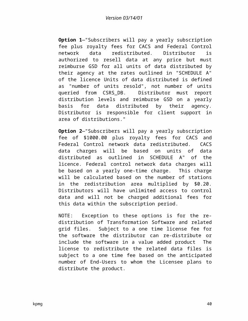
Version 03/14/01
Minerals and Energy Branch, Department of Natural Resources, Nova Scotia, has a policy and practice with respect to the pricing and distribution of digital geoscience data based on the belief that government geoscientific data collected through monies raised from the taxpayer should be made available to the taxpayer at little or no cost, and as expeditiously as possible. Charging for cost recovery purposes is seen as a form of double taxation to the customer. Traditionally, this meant that the branch sold its hard copy products and its digital products at the cost of reproduction (i.e., all CDs cost $10). However, with the advent of the Internet, they now make all of their digital data available for free. Clients may still purchase the digital products on diskette or CD at nominal costs if they wish, although sales of data in this medium have basically dried up.
When customers buy or download any digital product, the branch’s user license is included with the product. This license allows the user to do virtually anything they want with the data to simply use it, re-sell it, or repackage it as a value-added product. The MEB does not ask for any royalties or agreements, only that the Nova Scotia Government retains copyright to the data, and that the user should always acknowledge the source of the data. The license also contains a liability clause protecting the Nova Scotia Government from the client's use of the data or in any value-added product the client may make with the data. The concept behind this license agreement is to give clients as much freedom to do what they want with the data to maximize its use, and to maximize the client's opportunity for creating business and profit.
Ministry of Northern Development and Mines, Ontario collects, organizes, stores and distributes geo-science and mineral exploration information for the province of Ontario. The driving force of their policies are to make the information available to as broad an audience as possible, both nationally and internationally. They view this information as a competitive advantage to attract mineral exploration to Ontario, therefore they keep the charges to a minimum and are willing to share and exchange data with any other jurisdiction. There is a relatively new policy to recoup the costs of duplication. They license for single use only. If someone produces a value-added product they must remit royalties based on the reproduction costs for that type of media. They have compared their policy to some in the US and believe that the success that was achieved in the US is validation of this approach. They distribute via the Internet and their LIO Data Warehouse. The data is very price sensitive and this is why the price is kept to a minimum. MNDM believes they are meeting demand. Revenues go the Ministries consolidated fund.
Ontario Ministry of Natural Resources creates, acquires and retains a variety of data in order to carry out its mandate of managing the provinces natural resources. MNR tries to protect its intellectual property rights through the use of copyright protection as well as licensing agreements or memoranda of understanding. While they try to facilitate open, easy and equitable access to information it does try to manage the data as an asset. Fees are based on full cost recovery (market value) but may be waiver in a number of circumstances such as where it is in the public benefit, for public health and safety
kpmg 41

Version 03/14/01
purposes, for non-profit research purposes, for program purposes and where the market does not support full-cost price. At a minimum requesters will pay the costs of reproduction and administration. The policy for access to information came into effect in 1995. They expect that as the demand for digital data increases they will provide more data on-line at decreased prices along with more partnerships for data exchange. Therefore, they believe there is a need for standards between organizations. MNR licenses digital dealers who access information through an extranet where they download the information. Invoices are due monthly and royalties are collected on any data sales of the dealers. The price is $2 per EPS file and are able to purchase digital files at half suggested retail price. VARs will also have license and remit royalties based on the product, about 10% that goes to central revenue. Data sharing agreements are in place with municipalities and some forestry companies. They believe that millions of dollars of data are shared annually and this is a beneficial relationship for both parties.
Photocartothèque québécoise (PCQ), Service des applications géospaciales, Ministère des ressources naturelles du Québec (MRN) has been mandated to render available geographical information produced by the secteur du Territoire du MRN. The different “secteurs” of Ministère des ressources naturelles du Québec (Mines, Forests, Energy and Territory) are responsible for the production and maintenance of government geographic information. The “secteurs” of Mines, Forest and Energy assume the responsibility for self distribution of their data, while the PCQ has been put in charge of the distribution for the ‘’secteur Territoire’s data’’.
In terms of service pricing, the MRN’s policy specifies that all costs related to the distribution have to be included in the price to maintain a balanced budget. An objective the PCQ have been able to acheive for many years. All government departements, municipalities, private companies and individuals have to pay for the data. All products have a fixed price based on distribution costs. Other services or digital data extractions are priced at hourly rate. There is a licensing agreement for all customers buying more than $1,000 of data. There cannot be any re-sale without Value-Added Product agreement. Those agreements are to stimulate private projects by offering data at minimum initial price and royalties. In all cases the MRN retains copyright to the data and user have to acknowledge the source of the data. There is special agreement as with an oil supplier for emergency intervention in case of accident with a tanker-truck. Educational institutions are eligible to receive a 30% discount of the standard price.
The PCQ collaborates with 35 private companies, located in all Québec régions, to distribute the different topograpic maps destinated to the sports industries (camping, hunting and fishing etc.). Also a web site give general information and sample of almost all different products and services. The web site is informative for now but the PCQ have started a project to implement the e-commerce for “standard products” in a first step.
kpmg 42
Version 03/14/01
The Plan géomatique du gouvernement du Québec, which is under the responsibility of the MRNQ, could not provide information (through completion of the agency. questionnaire) in due time to participate in this study.
Teranet was formed in 1991 as a private/public sector partnership. It the land registration and parcel ownership system for the province of Ontario. Through its mapping products it provides accurately maintained ownership parcels. Teranet uses a number of leading edge delivery channels in order to get this information to its clients which is generally over the web. The POLARIS product enables tabular access to land registry information which can be streamed electronically to clients. The GeoServer data mart, an enterprise-ready GIS solution brings together all the Ontario land information thus enabling better decision making and more effective work. In addition they are creating Ontario's first GeoWarehouse, allowing municipalities and other clients to access complete mapping information over the Internet through customized portals and into the largest and most comprehensive mapping database in Ontario. The pricing structure is a subscription basis which varies by the client or a one time use price. It is seen as a less expensive alternative to individual databases. They have reduced the prices in recent years because they found that they were trying to recover too much of the costs when it was the creation and the maintenance. Teranet may be able to adjust the prices downward but they do not believe that it will result in additional use because the bulk of the users need the information in order to conduct their business, lawyers doing title searchers. The lower costs may not get passed along to the final beneficiary of the information, i.e., the person buying a home but higher Teranet fees definitely would. Current practice is to price for recovery of just maintenance. VAR will receive a discount to the standard prices. They have 57 layers of data. Universities and libraries will receive access for $1 annually. They review curriculum to see relevance of data to programs. Teranet pays royalties to the Ministry of Natural Resources.
D. Municipal agencies
We have received a range of input from municipal agencies that are developers, users, or suppliers of geospatial data including: Cape Breton Regional Municipality, Halifax Regional Municipality, the City of London, Montreal, Regional Municipality of Ottawa-Carleton, Simcoe County and the City of Toronto.
For the most part, municipal geospatial data policy groups have been given a mandate to develop, implement, operate, promote, and administer geospatial data as a corporate support for other activities of the municipality as well as make some level of data available over the web to the public. Municipalities use the web to provide information at no cost but for limited use and purposes, predominantly personal as opposed to
kpmg 43

Version 03/14/01
commercial. The web allows users to print maps of areas but does not generally provide complete data sets that can then be manipulated.
Cape Breton Regional Municipality does not have a formal cost recovery policy in place but does seem to be heading in the direction of cost recovery of distribution costs. They have developed substantial data sets of very high quality which they feel are often better than federal data sets and they have given these data sets to the federal departments requesting them. In the past, CBRM has bought data from NRCan and Statistics Canada but they have decided they will never buy it again because they can produce much better quality data. They would like to be able to cooperate with the federal departments but feel that their cost recovery policy is counter-productive. CBRM believes the free flow of information will increase in the future. When dealing with other government departments, CBRM tries to barter their data rather than sell it to other levels of government. The private sector is moving in and, eventually, it will be able to supply the same data to the government at a lower cost. The federal government's policies need to become more and more like those of the US government for geospatial data.
At the municipal level, there is no law pertaining specifically to geospatial data. However, relevant policies include the freedom of information and protection of privacy at the provincial level, which also applies at the municipal level. The privacy issue constrains the distribution of some of the data. This complicates matters because much of the personal data is linked with other data that is not private.
There are two types of licensing agreements in use by CBRM: one for resellers, which used to have a nominal recovery charge but it was later waived; and one for single/internal use where there is no charge. There are no restrictions because they feel it would be to hard to monitor.
Halifax Regional Municipality has recently drafted new policies and the guiding principles include: facilitation of the distribution of the data, removal of barriers to the sharing of data, ensuring that the data is of good quality and up-to-date and recovery of the costs of distribution. Before this there was no official policy. The current cost recovery practice started in Sept 1999 when HRM initiated its shared-service model (free between 1996 and 1999). In some cases, users have preferred to recreate the data rather than buy it from HRM, especially since the pricing structure followed a 3-year period of no-charge access. The current price is based on the market. Revenues are directed to the general fund. The internet will increase ability to disseminate widely.
HRM has two main types of licensing agreements. For example, with the Halifax Water Commission there is free sharing of data between the agencies with restrictions in the distribution of each other's data. The Province of Nova Scotia is more strict, in that both parties will disseminate information on each other's behalf but will try to confirm that the clients destroy the data once they have finished using it. No royalties are collected as it is too cumbersome and difficult to track. With respect to releasing and selling data,
kpmg 44
Version 03/14/01
licensing agreements are issued. For capital projects, there is no charge to prevent double billing. The charge fee is $100 per digital data extraction, regardless of the size of the data set (purchase of the complete data set is discouraged). Licensing is on a project basis, and HRM insists on the data being deleted at the end of the project.
When HRM does value-added products, they charge at hourly rate ($25/hr for technician time, $50/hr for project management, $100 for data license, and $5 nuisance fee for creating a CD). Users often request paper output and digitize for their own use so that they don't get into royalty/copyright hassles. They have never really been faced with a case of data resale or come across clients that wanted to do value-added product development. HRM is currently thinking about setting up a flat rate for centre-line file (road file, civic range and road range) at about $500 or $1,000 for the full coverage.
There is no resale of this data allowed. If HRM was to go back to a "free data" structure, as when the government had a mapping fund, then the licensing agreements would be kept so as to ensure data integrity.
The City of London has undertaken an initiative to reduce the cost of its complete city-wide data set in order to make it more readily accessible. Before 1999, the full data set was priced at $200,000. “Very few users, if any, purchased the data.” Since then they have decided to produce and sell a CD ROM for $250 which contains aerial photography (updated every year), 1:200 vector topo maps, property boundaries, single-line road network and a city map with an index and grid. They sell about 100 annually.) The purpose of the exercise was to encourage the use of this data for development purposes and by others who needed the data. They have increased use. Revenues go towards supporting the service. There are no reciprocal agreements as of yet but the City may make deals with special users on a case-by-case basis. In addition, if the City contributes data to other databases, they expect to have free access to such databases. They also expect to retain intellectual property ownership of that data and to be the sole entity responsible for its maintenance. They have compared mostly with other cities in their part of Ontario and have found that no other municipality has the same attitude towards data pricing policies. Most charge quite a lot for their data.
There are neither distributors nor resellers. The City is only starting to talk with federal agencies on data exchange issues. Between 3000 and 3500 maps are created by the public every day on the Web site. In the city's offices, the digital maps are used all the time by staff. The City strongly believes that the success/benefits of their policy reside in the wide use of the data, not in cost recovery.
Users need to ask permission if they wish to publish some of the data. Resale is not allowed and there can be no marketing use.
The Regional Municipality of Ottawa-Carleton has a cost recovery policy in place which is administered through its Surveys and Mapping Branch. The policy is to recover
kpmg 45
Version 03/14/01
the cost of distribution only. The prices for the products range from minimal for paper products too $20,000 for the full coverage topographical or road centreline graphics and attributes data sets. This policy was put in place this year. In addition, RMOC provides data free of charge on its website to meet many of the needs of its users. This data is covered by a license that restricts its use to internal and there are no rights to resale or further distribution.
The County of Simcoe hopes to be moving from a manual process of data dissemination to that of an application service provider for large scale users. They will do resale on the web and through a subscription basis. There are no restrictions on the data distribution but there is an MOU between the county and the 24 local municipalities and this details the principles of the way in which they all work together. Price and release agreements are in place. Royalties are collected and co-ordinated for all municipalities in the County office. That way there is one lawyer and one price structure. The sale of small parcel information is discouraged. There is no resale of the data allowed. They have had instances of people using old data in projects which has caused problems
Bell and Ontario Hydro are corporate members—they were in at the start and paid some of the seed money at the outset ($17,000). They get access to data on a preferred basis. Government members get free access to all data for $1000 per year. The data base costs $1.2 million to establish. All others pay as they go. About 2 CDs per week are released to groups like the Health Unit, MNR, etc in the co-operative. They get and handle 120 data requests per year. “The simple fact is that we collect once, use many times and everyone saves money.” The information is gathered through contractors. The digital map base is $5,000 plus $250 for an update. The civic centre line for 16 municipalities is $16,000. 50% of sales are still paper products. If someone asks for a custom activity the price is $60 per hour plus $15 for a 36” plot, generating approximately $10,000 per year.
Web-based applications have been passed on to schools for geography or business classes for web-based GIS. The internet is driving them to expand their infrastructure.
“The Province and the Federal government should realise who needs data and who should collect and maintain them. The municipality is the unit that needs the information, which is legally mandated to collect it, and is in the best position to update data. The biggest problem—royalties to MNR. They are high, too high for the products. Their products are priced too high, poorly maintained and generally a disaster. It would have been simpler to give everyone the data and see everyone use a common data base so that everything could be easily compared.”
The City of Toronto has no cost recovery policy but is debating internally what information should be delivered free of charge because its use will trigger a lot of economic activity. It may, however, charge for associated services. Overall they collect all data as required for local needs and obtain other information (such as that provided by Statistics Canada, Census and others) as required. They believe that other levels of
kpmg 46
Version 03/14/01
government should support local data acquisition to build up—the concept of food chain is useful—the municipality is at the bottom of the data collection food chain.
There is a lot of pressure coming from above and from the private sector to deliver data. They expect that free data and charging for services will, in the end, win out. The prime objective is to serve the organization, not to make money. The internet will help them to reach this goal. They are encountering problems with federal and provincial restrictions on data distribution. Since 1993, they ask people not to resell.
There are four foundation data sets. (1) large scale maps—1 foot information; (2) streets and addresses; (3) parcel mapping; (4) horizontal and vertical control. Provincial governments share information and distribute it free. There is a provincial and municipal data sharing alliance and everyone pays for a common repository. They hope that the federal government will follow suit soon.
Montreal Regional Municipality Geomatic Section has been mandated to produce and update basic geospatial data for municipal purposes. Currently the section does not have a formal cost recovery policy in place since the data is primarily used by different municipal services and private companies working for the city. The Geomatic Section is however trying to set up alliances with potential partners in order to share some of these costs.
At the municipal level, there is no law, policy or constraint pertaining specifically to geospatial data. The main dilemma the city is currently facing is a desire not to compete with the private sector. As a result of this desire, certain categories of data are not made available to external users (e.g., Montreal subway maps).
There are three types of agreements in use by the Geomatic Section: one for internal users, one for external users and one for educational users. Internal users include both other municipal services and private sector companies working for the city. Internal users do not pay for the data. Education users which includes colleges and universities, do not pay for the data when it is for educational purposes. In contrast to internal and educational users, external users have to pay for the data.
1. Municipal summary
One very interesting aspect of the municipal approach to data distribution and pricing is the aversion to reselling the data. While there is support for the idea that access to the best data for decision making purposes can have a positive result in terms of economic stimulation, this limit on reselling deters from allowing commercial activities to be based or developed upon the data that has been collected for municipal purposes. The municipalities that were engaged are evenly split on the issue of reselling data. Some expressly forbid the resale of data and will only allow internal use of the data through licensing agreements. Others will
kpmg 47

Version 03/14/01
allow resale but seem to limit their interest to the initial transaction and will not collect royalties (except Simcoe County) or track the use after the initial transaction because it is too cumbersome of an endeavour.
In commentary received from staff at the Government of British Columbia, it was noted that there is quite a broad spectrum reflecting those who have been at this for some time (Burnaby, Vancouver) to those who are still working with paper and counter service and even the area of some of the Regional Districts which can be in the order of 200,000 sq. km. (Fraser Fort George, Peace River).
Where the Municipality has made large investments in generating data, particularly cadastral, there is a strong incentive to recover costs to offset the ongoing costs of data maintenance. This is particularly evidenced where there may be large corporate clients such as the utilities. Currently there is an initiative, ICI (Integrated Cadastral Initiative, (Crown Land Registry Services) to set up a large partnership that would bring provincial crown data and Municipal (private ownership, Land Titles) as well as other ownership and address related attribute information together. Even within such a partnership many of the Municipalities wish to maintain control over their data. So even though the data goes into this conglomerate, royalties would flow back to the Municipality based on their rules of pricing and distribution. For others, such an arrangement is seen as a better way of doing business and they are not so focused on the recovery aspect. Without the benefit of in-depth interviews, the observation was that this seems to be more a function of the investment that has been made in current infrastructure...the larger the investment....the greater desire for cost recovery. Data exchanges are also on the rise. This helps get data into the hands of the various organizations who require the data for their day to day business but due to restrictions on redistribution, it often does not address access outside of the agreement partners.
All municipalities that were engaged during the process expect that the internet will or has provided additional opportunities for them to reduce the price of their products as well as to widely disseminate their data. Most municipalities expect to be focusing their data delivery on the internet and enhancing the data that is available on the web.
In conclusion we see that significant efforts are expended at the municipal level collecting, administering and producing geospatial data in order to meet the needs of their local operations. The costs for data at the federal level have a direct affect by restricting the use of the data by municipalities. This lends itself to duplication, in that data is gathered for municipal purposes in order to avoid the costs of the federal data. There seems to be a willingness on behalf of municipalities that were interviewed to develop closer relationships with federal departments and to feed into federal databases. Some municipalities have also recognized for themselves that the free distribution and access to quality data is an economic generator for
kpmg 48

Version 03/14/01
their respective areas and that the cost of data can be an obstacle, while others see cost recovery as a means of defraying the costs of data that many clients seem willing and able to pay for.
E. The economics of Canadian data agencies
This section provides some insights into the cost and revenue analysis of the federal, provincial and municipal agencies interviewed in the study. It should be noted that the following findings represent only a portion of the agencies surveyed as many either refused or neglected to provide financial information. In addition, in some instances assumptions had to be made to conduct the analysis. Therefore, the following financial analysis provides an indication of the economics of the Canadian data agencies.
There are a large variety of data pricing models and structures being utilized by data producing agencies at all levels of government within Canada. While it is difficult to precisely categorize all agencies due to the variety of sizes, mandates, type of geospatial activities and other characteristics of the data agencies, when relevant a number of agencies sharing similar qualities are grouped together.
1. Overview of expenses
Agencies vary greatly in terms of size and scope of their budgets. A typical federal framework data agency has an annual operating budget of just over $8M, while a typical federal thematic data agency has a budget ranging from just under $2M up to $7M. In general, municipal agencies are the smallest geospatial data agencies with about $1.7M in expenses (the expenditures for the municipal organizations that supplied data vary significantly from $120K to $3 million) and provincial agencies have a wide range of annual budgets, from around $3M up to $18M.
Exhibit II-3 provides a distribution of expenses for a typical federal framework and thematic agency, as well as an average for provincial and municipal agencies.
kpmg 49
Version 03/14/01
Exhibit II-3Distribution of operating budgets of data agencies
Budget allocation (%) Federal Framewor
k
Federal Thematic
Provincial Provincial Transactional16
Municipal
Data collection & research
44 35 23 17 9
Data production & processing
7 27 24 33 25
Data maintenance 6 14 11 15 28Data storage 14 10 4 4 8Marketing/promotion 4 3 2 4 3Data distribution 7 5 17* 4.5 8Fee collection & sales support
2 1.5 2 5 4
General overhead 12 7 13 17 10Other 5 0 3 0 7* The large overall distribution percentage is due to a few provincial agencies which primarily function as distributors of data to various industries, and so have un-proportionately high data distribution costs compared to other budget allocations.
The cost of distributing data to clients of federal agencies ranges from 1-10% of an agency’s expenses. It costs a typical framework-data agency 7%, and a thematic-data agency 5% of its budget to provide and deliver data. Of the federal agencies that reported expenses for fee collection and sales administration, the level of costs tend to range from 2-5% of the overall budget of the agency. It is believed this figure is understated as some agencies do not track the level of effort needed to collect data revenues. Most federal data agencies are near the federal average of a $6M budget.
On the provincial level, the cost of distributing data generally ranges from 2-10% of budget, although a few agencies reported much higher distribution expenses due to the nature of their mandate and function. Provincial data agencies varied the most in terms of size, with budgets ranging from a few hundreds of thousands of dollars to nearly $18M.
The municipalities spend very little in data collection and research compared to other levels of government. This would indicate price sensitivity for data. Maintaining and managing the varied data sets uses the largest proportion of a municipal agencies budget. The size of a municipal data agency budget tends to
16 Provincial transactional data agencies are a sub-set of the provincial agency survey population. They have been shown separately due to their activities and unique characteristics.
kpmg 50
Version 03/14/01
correlate with the size of the city—smaller cities tended to have data agency budgets in the area of $200-300K, while larger cities in the sample have agencies with over $3M in expenses.
2. Overview of revenues from digital data
Revenues for data producing agencies occur primarily when an agency sells the data it has collected or manipulated to a re-seller/application provider or end-users, which could include government agencies or private sector entities. The approach to data pricing that was encountered within the data agencies ranged from free data provided over the web to recovery of the costs of production and dissemination. For example, generally agencies within the NRCan umbrella employ the cost recovery policy. However, even the agencies that provide data for free or for a marginal cost will charge for value added services. Typically the charge will be based on hourly rates for technical and professional staff time in order to extract, manipulate and package the data to match a particular request.
On the federal level, the responding agencies’ combined sales revenue amounted to $4.9M, with an agency average of $800K. Federal agencies had revenues ranging from under $100K to over $2M (interestingly, the agencies with the least and most geospatial data sales revenues were from the same department). Other government departments are the largest customers of federal data (acquiring 45% of the federal data distributed). The private sector bought 42%, the general public about 6%, and academe and non-profit purchased around 7%. Federal framework data agencies received approximately 75% of their data revenues from the sale of topographic data. Appropriately, federal thematic agencies received 93% of their revenues from the sale of non-framework data. Exhibit II-4 provides a summary of the major client groups, by level of agency supplying the data.
Provincially, sampled agencies reported a total of $6.6M in revenues from data sales, with an average of $500K per agency. Data sales ranged from about $20-40K for half the respondents, up to well over a million dollars but a quarter of the agencies. The largest client base of the data sales is the private sector (55%). Other government departments acquired 31% of the data, the general public about 9%, and academe and non-profit together bought about 6%. Approximately 43% of the revenues came from topographic data sales followed by nearly 30% from cadastral digital data products.
On the municipal level, the agencies contacted reported a combined revenue from digital geospatial data fees of $218K, with an average of $36K per city. Revenues ranged from a few hundred dollars to one with $100K in sales. The private sector bought 43% of the data followed closely by other levels of government at 41%. Academe and non-profit together bought about 10%, and the general public around
kpmg 51

Version 03/14/01
5%. The largest source of data revenues for municipalities is road network data (51% of revenues) followed by topographic and cadastral (37% combined).
It should be noted that much of the current cost recovery practices are adversely affecting other government departments. Based on our sample, over $4.3M of the $11M generated in revenues from the sale of digital geospatial data is between government departments.
Exhibit II-4Summary of percent of data supplied to client groups
Clients Federal agency suppliers
Provincial agency suppliers
Municipal suppliers
Government 45% 31% 43%Private sector 41.5% 55% 41%General Public 6% 9% 5%Academic 4% 4% 5%Non-Profit 1.5% 2% 3%Other 1% 0% 2%
Exhibit II-5 provides a comparison of the cost of reproducing and distributing geospatial data (the costs for fulfilling the user request (such as buying, copying and mailing a CD-ROM with data files on it) that would technically be eligible for cost recovery under the Treasury Board policy) versus the actual fees generated from the different types of typical federal data agencies, as well as provincial and municipal agencies.
Exhibit II-5Cost of data dissemination versus fees collected for data agencies
Typical Agency Type Cost of data disseminatio
n17
Fees generated18
Net FeeImpact on budget
Federal Framework 14.5% 13% -1.5%Federal Thematic 10% 7.5% -2.5%Overall Federal (average) 10.5% 10.5% 0%
17 Cost of data dissemination includes costs related to data distribution, marketing, fee collection, sales support, and a portion of overhead expenses.
18 While the survey asked for the fees generated from digital geospatial data sales, a small amount of the revenue reported may be from geospatial data derived from value-added services.
kpmg 52

Version 03/14/01
Provincial Transactional 12% 7%* -5%Provincial (average) 1723.5% 14% -9.5%Municipal 16% 5% -11%
* One provincial agency with 95% cost recovery acted as an outlier and was removed to present a more representative figure.
The price assigned to geospatial data contributes to a level of sales that exceeds the cost of distributing the data and fulfilling user requests for the typical federal data agency. When costs for marketing, fee collection, sales support and a portion of overhead are included, the overall cost of selling and disseminating data becomes 14.5% for Federal-framework agencies, and 10% for Federal-thematic, less than the revenues generated. This would imply that the sale of geospatial data at the federal level covers some of the selling and distribution function, but does not have a large impact on other mandated requirements such as data collection or maintenance.
The provincial data agencies that have a primarily free data pricing policy tend to collect approximately 1-4% of expenses as revenue. Generally, the few transactional-data based provincial agencies collect around 15% of their costs from revenues, with one agency bringing in fees of nearly 95% of their annual budget. Most of these revenues are from topographic and cadastral data products or services. When the costs for selling (marketing, fee collection and sales support) are included with the costs of distribution, the average net loss for a provincial agency was 9.5%, while the average net loss for transactional agencies was 5%.
Municipal data agencies bring in revenue primarily from sales of roads/street network data files (36% of the data) followed by topographic data (30% of the data). Fees collected annually from clients range from a few hundred dollars to over one hundred thousand dollars from larger municipalities. Larger municipalities tended to provide more data to the local industry or public (approximately 65%) than smaller municipalities (about 35%). In all municipal agencies contacted, the level of sales from geospatial data (average 5% of expenses) was less than the cost of distribution (average 8%). In fact, when related costs for selling the data are included, the net loss increases from –3% to –11%. Obviously these agencies are not trying to make revenues to contribute to their budgets. Most of the municipalities employ cost recovery mechanisms for some range of products and services. Costs are recovered for paper products, mylars, CD ROMs, and the costs of operators for customisations of data sets, the creation of special thematic data and other value added services.
3. Levels of cost recovery—from free to fee
Federal data agencies employ the Treasury Board Cost Recovery policy but to varying degrees, as shown in Exhibit II-6. In fact, a few agencies are realizing significantly higher revenues through their implementation of their pricing policy
kpmg 53
Version 03/14/01
then the costs the policy is meant to cover. Meanwhile, another agency has a significant budget and provides framework information on the Canadian land mass, but it has a cost recovery practice of around one percent. This agency determined that the cost of marketing and distribution of digital products was simply not worth the effort and wanted to generate greater impact by having more information in the hands of Canadians.
Exhibit II-6A sample of federal agency pricing policies and practices
Size of Agency Large Medium Small Med/LargePrimary Type of Data Framework Framework Framework Thematic19
Cost of Selling and Dissemination
14% 15% 14% 10%
Cost of fee collection (part of selling & dissemination expense)
4% 2% 4% 2%
Revenue as % of expenses 25% 1% 12% 7%Revenue (less collection costs) 10% -14% -2% -3%Pricing Policy COFUR Mostly Free Partial COFUR COFUR &
marketingProportion of data sales to government users
25% 20% 50% 40%
Proportion of data sales to public/industry/academia
65% 70% 45% 55%
One important influencing factor within this discussion of federal agencies is the mandate of the organizations. Some agencies generally provide a supporting role to other internal lines of business or programs within their department or agency. Other agencies generally have a mandate that is, at its core, the collection or maintenance of digital data for the purposes of distribution to other governmental entities. It is interesting to note that one agency that follows a free data distribution policy provides free data that is derived from data originally supplied from a cost recovering agency which is then re-digitized for the use and eventual distribution.
19 Many thematic data oriented federal agencies did not provide full financial information to enable additional sample agencies to be included in Exhibit II-5.
kpmg 54
Version 03/14/01
F. Summary of data policy and practices
Based on the interview material and survey responses a number of trends, commonalities and issues are evident in the Canadian geospatial data environment. The following section is a summary discussion of the policies and approaches to cost recovery, data dissemination, data sharing and usage that were described by the survey respondents.
In general, the agencies sampled provide framework and thematic data either at the municipal, provincial or federal level. The federal agencies that were surveyed were predominantly providers of thematic data. The thematic agencies recover less of their costs and tend to supply more free data. These agencies generally supply the information in support of other key objectives. In these cases it would seem that the organization can justify the subsidization of their geospatial activities as part of the overall benefit to their department or mandate. For example, Agriculture supplies free data in hopes that it will lead to better decisions that will support other key activities of protecting agricultural land. The same can be said for Elections Canada and Canada Post. The crux of the issue would seem to be the quantification of the benefit of free access in the business case that is developed for or against the recovery of costs. The National Atlas of Canada has placed a high value on the public benefits to be achieved through the wide distribution of its data and this is translated into its practice of high accessibility to data.
Four of the ten agencies that were surveyed were primarily providers of framework data (these agencies are part of NRCan). While cost recovery is a Treasury Board policy that applies to all of these organizations the implementation and practice seems to vary. The Centre for Topographic Information and Earth Observation Satellite both recover a substantially higher portion of their operating budgets than does the National Atlas of Canada and Geodetic Survey. Most framework data agencies have a mandate to collect and distribute but do not necessarily use the data as support for there own internal activities, e.g. they collect data in support of their ice clearing operations or promotion of the mining industry etc. These framework data agencies are client focused.
One very interesting trend has been the development of information utilities (corporations mostly) by the Provincial governments in order to sell the framework data that they have developed. This occurs in BC, Alberta, Saskatchewan, Manitoba, and New Brunswick, with Nova Scotia pursuing this model in the near future. In conjunction with the selling of data, these information utilities are generally responsible for the maintenance of the data and upgrades, as well as transactional activities such as survey control within the province. AltaLIS was formed as a response to industry pressure for more up to date information and includes aspects of market incentives to encourage the use of its product in order to facilitate more timely and efficient updates to the data through rebates to individual surveys for using the AltaLIS base map for their work and partnerships. This tends to be more flexible and responsive to the client in terms of price structure and product availability. For example, subscriptions are used for updates as
kpmg 55

Version 03/14/01
opposed to purchasing a complete data set annually whether or not there have been any changes, or data and prices that vary by area and size are employed. One commonality of the information utilities is the partnership approach for the initial development. Many involve the province, municipal governments as well as major utilities such as hydro, gas and other large private entities.
There seems to be a much stronger partnership and data exchange approach within the provincial and municipal relationship than with the Federal government either internally or with other levels of government.
In many cases the restrictions that are placed on the use of the data can be just as much a barrier as the cost. In addition, the restrictions of a framework data agency are passed on to others in the chain of data distribution resulting in a system that is hard to monitor. For example, the Geodetic Survey data usage agreement is very complex and as the data is incorporated into other products, the onus is placed on the product developer to remit the product to the agency to ensure that it is adhering to the agreement. Many other agreements at the Federal and Provincial level require that the data should not be able to be extracted from whatever value added product is being distributed whether it be flight simulation software, a GPS device or other data products. At the municipal level, many have taken the approach of no limitations on use or resale while others have strictly forbidden the resale and use can only be for specified projects that are generally of a municipal nature. Some agencies even require files to be destroyed upon completion of the project.
As there are no common processes for access, licensing and use of data products across Canada at either the Federal, Provincial or Municipal level, there are immense challenges when developing a national technological products and services.
1. Criticisms of federal data policy
Throughout the discussions there were strong beliefs that the cost recovery policy and the licensing agreements used by federal agencies establish barriers to the data’s dissemination and resulting benefits. In one instance the cost recovery policy has actually been an impediment to the use of NRCan data as well as the further development of digital data by a province. Recently, the province of Manitoba attempted to enhance its geospatial data depository. It had successfully updated the data of the southern half of the province to 1:20,000 mapping and was negotiating access to the northern data. Manitoba wanted to exchange this new data in the south for the older data in the north with NRCan. Due to the pricing practice in place, the 450 map sheets would cost the province $1,000 each.
In another case a particular agency takes NRCan data and re-digitizes it, thus losing many of its attributes and accuracy in order to avoid the restrictions that the straightforward use of the digital data would implicate. Other agencies share a
kpmg 56

Version 03/14/01
philosophy which is to collect data on their own because the federal data is too old, of poor quality and too expensive in relation to the cost of their own data collection process. Some of this criticism can also be levelled at Statistics Canada in terms of its cost recovery practice. Some believe that federal data agencies, while adjusting their prices downwards, the result has been substantially higher costs then the same information offered by the provinces.
In a paper criticising the Federal Treasury Board policy of cost recovery on information-based goods and services, Harry Chartrand notes: “Information is non-rival in consumption. In fact, it appears to have the opposite characteristic, i.e. it is collaborative or additive in consumption. In the case of research, for example, consumption of information by one researcher leads to production of new information by other researchers leading to more consumption and yet more production.”
“Business runs on informationinformation about markets, about competitive products and services, about new scientific breakthroughs, about demand and changing demographics of customers. All things being equal, the more information available, the better the decisions made by business. Federal information is no different. If Canada is to be competitive with other nations its information costs must be competitive. …Crown copyright and more limited exemptions from copyright infringement appear to make Canada less competitive relative to the United States. Federal information user charges would tend to increase this burden.”20
G. Economic and social impacts of geospatial data dissemination
It is quite difficult to concretely attribute and quantify the impact of broader geospatial data use in an economic or social context. While the debate over cost recovery has raged on for years, few definitive answers have emerged pointing to the net loss or gain in an economy from either proprietary or open distribution of data. A number of macro-estimates, anecdotes and rhetoric that have emerged will be explored briefly here.
What is clear is the linkage of geospatial data, into more and more applications in business and social situations to develop knowledge. On a broader scale, there are numerous papers and articles on the importance of sharing and disseminating data to develop knowledge, innovation and technology. Leading economists in new growth theory suggest that the ability of firms to identify and secure low-cost information
20 Harry Hillman Chartrand, "Rusty Nail on the Information Highway: User Charges and Canadian Federal Government Information," Government Information in Canada 3.4 (Spring 1997).
kpmg 57
Version 03/14/01
resources is vital to stimulating economic growth in an information-based economy. 21 In a paper to the SchoolNet Advisory Board, Dr. John de la Mothe of the University of Ottawa writes: “the ability of Canada to access, diffuse and apply new knowledge will be key to its future and continuing success.”22
1. Economic models and indicators
A number of economic indicators of the impact and importance of geospatial data have been provided to the project team. Interestingly, while coming from both Canadian and Australian respondents, all of the following models have been cited as Australian. Probable studies’ results have shown:
that for every $1 spent by government on providing modern high quality geo-scientific data, $4-10 was spent by the private sector, which in turn resulted in the discovery of new resources worth $100 to $150;23
that for every $1 invested in producing spatial information, $4 of benefit was generated within the economy; 24 and
that use of remotely sensed data generated savings to user industries of $4.50 for each $1 spent on SPOT and Landsat data.25
While all three models have been submitted with references to three unique original studies, it is evident that striking similarities exist between then. While this does not call into question the findings or their relevance, it does indicate that establishing clear and accurate socio-economic impact models for geospatial data is not an easy task. Such model analysis would require an analysis of national econometric data that currently does no exist for the GIS sector.26 What the models do indicate is that extra value is added to the economy in the effective use of data, over and above the initial input costs. This demonstrates some of the social and
21 Xavier Lopez, “Dissemination of Spatial Data—A North American-European Comparative Study on the Impact of Government Information Policy”, 1998.
22 John de la Mothe, “Some Economic Consequences of Knowledge, Information and ICTs”, prepared for the SchoolNet Advisory Board, September 1999.
23 Comment made by AUSLIG representative referring to Australian geomatic data usage.
24 Price Waterhouse, “Cost/Benefit study for the capture of Land and Geographic Data Infrastructure in Australia”, 1994.
25 Price Waterhouse, The Economic and Social Benefits of AUSLIG's Public Interest Program, 1992.
26 Lopez, “Dissemination of Spatial Data”, 1998.
kpmg 58
Version 03/14/01
political objectives, as well as large economic and environmental externalities that Bird and Tsiopolous described as characteristics of public goods. In addition, geospatial data generally have low marginal costs to supply additional data sets due to their digital nature, and high lumpiness or sunk costs associated with gathering the data and its analysis.
Some geomatic industry-specific macro-economic indicators include:
The world market for geomatics products and services is estimated to be $10 billion. The market appears to be growing at a rate of 20 percent per year. 27
With restrictive data policies in Canada, US and other countries seem more competitively positioned to capture most of this growth.
Canadian exports of geomatic products are estimated at about $260M, the largest component of which is systems and software.28 Geomatic and consulting services exports fall behind the technology exports.
The lead that Canadian firms were once considered to enjoy in the provision of geomatics services is disappearing and, in some areas, the US has already surpassed the Canadian industry.29 A forthcoming Human Resource Study of the Canadian Geomatics Industry should shed some light on the relative strength and growth rates of the Canadian industry versus the US industry. However, most indications currently, albeit anecdotal, point towards a relative decline of the Canadian industry compared to the US.
US firms are able to produce goods and services more efficiently than firms in Canada. The American firms incurred lower costs to generate the same operating revenue as Canadian firms.30 While the higher-level and flexibility of American firms accounts for a portion of this, inputs (data cost) into the goods and services sold account for some of the reason Canadian firms are not as competitive.
2. Examples of data impact
In addition to economic models, anecdotes and examples of the negative impact of geospatial data were provided as input to this study. In most cases these are
27 Industry Canada, Geomatics Sector Competitiveness Framework, prepared by Smith , Gunther Assoc. Ltd., 1998.
28 Ibid.
29 Ibid.
30 Ibid.
kpmg 59

Version 03/14/01
included in the relevant sections in which they were provided for. However, a few samples are summarized here to illustrate the point:
The results of the overall federal cost recovery program are negative: higher prices and reduced products and services. The overall economic consequences are fewer jobs (23,000 less), a reduced economic output by almost $2.6 billion, and a lower gross domestic product (GDP) by nearly $1.4 billion.31
A moderately popular data product in the environmental sector was re-introduced at a price 50 times more than previous, after using new technology that supposedly reduced the cost of data collection. At this price, few public, private or academic clients could afford it. With a production cost of $115K, six copies were sold, totally $6K in revenue, two of which were to government departments. It hardly seems worth the effort to try to sell the products at all.
Several police departments in Canada, which cannot afford to access digital street maps, are limited in their ability to coordinate pursuits of serial sexual assaults.
Numerous leading academics are forced to use readily available US geomatic datasets in their research and teaching due to the copyright limitations imposed on Canadian data and the fact that their research libraries cannot afford to buy the data products due to price increases.
And some US-based examples to illustrate effective data policies and their impact:
US policies promoting free, unrestricted access to global positioning system (GPS) positional data, has helped place its GPS industry in a leadership position in the international commercial GPS hardware and software market.32
In an interesting development, the US and Russia collaborated on a series of polar sea atlases on CD-ROM. The first product was available at $50 per CD-ROM, which represented little more than the cost of dissemination. Canada attempted to participate, but that proved impossible as its data could not be released. Ironically, it may be easier to get climate data from Russia than from the Government of Canada.33
31 Blair Consulting Group & CME, Where Does the Buck Stop?, (Quebec), January 1999.
32 RAND Critical Technologies Institute, “GPS: Assessing National Priorities”, 1995.
kpmg 60
Version 03/14/01
“IT-producing industries (i.e., producers of computer and communications hardware, software, and services) that enable e-commerce play a strategic role in the growth process. Between 1995 and 1998, these IT-producers, while accounting for only about 8 percent of U.S. GDP, contributed on average 35 percent of the nation’s real economic growth.”34
3. General comments regarding data impact
Although quantifying the positive economic and social spillover benefits from wide government geospatial data dissemination, many arguments can be made for supporting full and open exchange of geomatic information to support Canada’s economic development goals. Some arguments include:
Should cost recovery be removed from Canadian geospatial data, many of the major governmental data providers would show a decrease in revenue, but the costs spent managing fee collection and trying to control and monitor use would be eliminated, and tax revenues (business taxes and GST from the increased supply and sale of data products and services from the geomatics industry) would effectively pay for the government’s geospatial activity.
The government collects and develops large databases in the conduct of its mission and mandate. This is a lumpy investment activity requiring resources far exceeding individual firm capabilities. This valuable natural resource is of interest to other stakeholders, and should be a commodity in the marketplace.35
The free flow of information between government and the public is essential to a democratic society. The government must also maximize the usefulness of this data. This is reflective of important social and political objectives as well as the generation of positive externalities described by Bird and Tsipolous.
Efficient sharing and exchange of government supplied data fosters excellence in academic and scientific research and the effective use of national research and development funds. The emergence of Statistic Canada’s Data Liberation Initiative is an example of increased dissemination
33 Canadian Library Association, Submission on “Estimates 1997-1998: Part III: Environment Canada”, December 1997.
34 U.S. Department of Commerce. June 1999. The Emerging Digital Economy II. Office and Policy Development. Washington, D.C.
35 A majority of these inputs are based on key assumptions and findings Xavier Lopez has developed in the research for the publication “The dissemination of Spatial Data”, 1998.
kpmg 61

Version 03/14/01
of geospatial data to Canada’s research and academic community through the reduction of the data price point. However, as academic institutions face increasing budgetary restrictions, the cost of data may still limit its uptake, and in some cases access to specific data outside data sharing agreements is prohibitive.
The use and application of data by the end-users for socio-economic gain must be assisted by a distribution process suited to the users’ needs.
Cost recovery and revenue generation are short-term interests—costs to the public interest, commercial innovation, environmental protection, resource management, job creation, and planning and coordination over the long-term outweigh the fees charged. The revenue-generation approach may not recognize the hidden costs associated with forgone economic opportunities.
Innovation in the GIS industry is driven, to a large part, by access to low-cost public domain datasets that can be enhanced and complemented by commercial value-added processes that generate growth in an electronic market for spatial data products and services.
Cost recovery and revenue recognition has resulted in price increases coupled with growing intellectual property restrictions which decrease access. This does not provide a setting conducive to rapid economic growth in the GIS sector or the economy as a whole.
Setting prices above media or reproduction costs put a large part of the Canadian geospatial information infrastructure out of reach from ordinary citizens, students, non-profits organizations, environmental groups and researchers.
The main goal of Canada’s data policies and approaches should be the growth in reutilization of the data. Success will be determined by how fast Canada, and its federal agencies, can supply the market with the data and tools (products and services) that will satisfy the demand. The end market does not want complicated data. It wants solutions (consumer products and services, or value-added products produced from geospatial data). The role of the government agencies in the development of a strong value-added industry is crucial.
Quite certainly, the high cost of some geospatial data files in Canada is limiting academic research and effective public sector planning, as well as potentially curtailing commercial development. Success in these areas is not solely contingent upon free or freer data, however access to quality data at a reasonable price (for the consumer) is a key factor. To summarize the link between geospatial data and
kpmg 62

Version 03/14/01
growth and development, Exhibit II-7 presents a succinct framework in which effective use of data is tied to benefits and outcomes in various realms of the socio-economic environment.36 Exhibit II-8 demonstrates the enormous cost difference when comparing government supplied data in Canada with that in the US. The cost differences are somewhere in the area of 1,300% and 7,200% larger—this clearly indicates the limits and challenges facing Canada’s economy in a competitive global marketplace. Besides the cost issue, the Canadian approach to distribute data is to use copyright and royalties as opposed to the US approach which only tries to recover reproduction costs (i.e., media of the data) without trying to recover overhead and other data administration costs.
Exhibit II-7Framework for the socio-economic impact of geospatial data
36 National Academy of Public Administration. January 1998. Geographic Information for the 21 st
Century: Building a Strategy for the Nation. Order # 98-01. Washington.
kpmg 63

Version 03/14/01
GI Product (Input) Outcome1. Property Rights and
Voting Rights Real Estate Elections 600
Property Records (Historic/ Current) Census Data
More eff icient: Real estate markets Reapportionment
2. Revenues from Property
Government Revenues
200
Location/Value of Properties Location/Amount of Natural Resources Jurisdictional Boundaries
Enhance Revenues, w ith less effort f rom: Real estate taxes Mineral and oil leases Timber sales Payments in-lieu-of-taxes
3. Transportation, Navigation, and Commerce
Commuting Business Travel Leisure Travel Freight/ Goods Movement 600
Planning Environmental GIS Construction Designs Performance Monitoring Navigation Charts
Less congestion and pollution More mobility and access More eff icient goods movement/ w orld trade Less impact on the natural environment and human settlements Safer navigation
4. Public Land and Marine Sanctuary Management
Minerals/Oil Timber/ Grazing Recreation
5. Agricultural and Natural Resource Development
Agriculture
6. Environmental Protection and Ecosystem Management
Environmental Equipement and Services 200
Wetlands/Habitat Vegetation Water Soils Pollution Monitoring
Sustainable development
7. Community and Economic Development (including utilities, housing and public w orks)
Construction Homebuilding Public Works 600
Demographic/ Economic Analysis Land Use Infrastructure Systems
Better Communities More good job opportunities
8. Emergency Management
Insurance Emergncy Services Recovery Services 150
Natural Hazards Infrastructure Emergency Operations Facilities Demographics
Reduced losses from emergencies Quicker, better recoveries from disasters
9. Public Service Delivery (including health, education, social, criminal justice, etc.)
Public Sector Nonprof it Sector Private Contractors 628
Demographics Service Facilites Locations Case Locations Infrastructure
More effective and eff icient public services
10. National Defense Defense Establishment
270
Navigation Charts Current Imaging Field Operations Maps Transportation Facilities
Domestic GI products that meet U.S. military and anti-terrorist needs
11. Earth System Sciences and GI Technologies
Government Research Labs > 10
Better Science Better Earth-Measurement Technologies
Understand the Earth better Better geographic information
Easier access to land records Better stew ardship of the land Multiple-purpose management Improved customer satisfaction
Importance to the National EconomyEconomic Purposes Relying on Geodata
Geological Maps Public Land Surveys Property Disputes Ecosystem Management Recreational Maps
300
Contribution of Geographic InformationEconomic Sector
Size of Sector (G$US)
While the chart is US-based, it is applicable to the Canadian context. Numbers provided in the “Size of Sector” column should be disregarded.
kpmg 64

Version 03/14/01
Exhibit II-8Comparison of US to Canadian data prices for a sample of products
Sample of US national data Price($US) Media Comparative Canadian data Price($CDN)US Census TIGER $1,500 CD-ROM Stat Can equivalent (1996) $20,000USGS DLG $500 CD-ROM NRCan Cdn Road Network $36,733US Digital Elevation Model Free Internet National Atlas of Canada Free
4. Does free data have value?
A number of individuals interviewed believe that if data are supplied for free there is a perception that users may believe the data have little or no value. However, a model does exist that provides evidence that free data is available and is readily accessed by numerous public and private sector organizations through the Internet. Of particular importance, GeoGratis is now the largest single collection of freely accessible geospatial information in Canada. This organization has set a goal to increase the utilization of its key national data sets. Based on web downloads the utilization is increasing dramatically, with nearly a quarter of a million downloads, totalling almost 130GB of data, in 1999 alone. The fact that 28% of the organizations using data from GeoGratis are Canadian federal or provincial government departments indicates that there is a demand for at least some types of readily available geospatial data at no cost within the public sector. Of the Canadian federal government users, the most active department downloading data from GeoGratis is Environment Canada (33% of the downloads), followed by Indian and Northern Affairs (19%), Fisheries and Oceans (17%), and NRCan (13%). The widespread use of this and like models support the notion that value is not in the price or cost of information, but rather in its use. To support the argument that free data has value, one just has to look at the example of the USGS which distributes federal data freely in the US—the amount of individuals, companies, academics, and government departments accessing and using the USGS data speaks volumes to its value and worth to the US economy.
The question of free data’s value revolves around the challenge to define quantitative value because the data are not sold or made available to the market at a price. Alternatively, just because cost recovery assigns a price to a data set, it is no more an indication of the value of the data than an arbitrarily allocated price point. No data is truly free—someone has paid for its production, access and distribution expenses—in the case of GeoGratis, the data are paid for through the NRCan departmental budget which is allocated from the aggregate tax base of the Canadian economy.
From the client perspective, value is perceived in the quality, applicability and usefulness of an asset, no matter the price. In fact, in economic theory, “consumer
kpmg 65

Version 03/14/01
surplus” is the state at which consumers are realizing extra value and benefits from a product above and beyond the price they have paid—this concept can easily be applied to free or near free geospatial data. In the academic world, information of value is readily shared through publications and other forms at a fraction of the cost of deriving the information (i.e., findings from scientific studies in a journal of medicine). With limited budgets, researchers, students and educators surely will value a free good.
It is also argued by some that if goods and services are free, consumers will tend to exhibit excess demand and will over-consume. With the advent of the Internet, reproduction costs for data are minimal. “Excess demand” of government supplied data will not hurt anyone—in fact, many argue wider distribution and lack of strict copyright of geospatial data in the US is a main reason for the growth of the GIS sector in that country and the shrinking of Canada’s prominence in the technology after developing it. Information is an usual commodity in that it can be used and re-used without losing its value. However, some incentives, (such as feedback regarding data accuracy and updating, or the inclusion of government data supply agencies in industry collaboration), that resulted when prices were assigned to the data files, may be lost should data be free. Alternative incentives need to be built into a free data model through innovative data sharing and contractual agreements and other tools.
Once framework data content are provided to a VAR for free, assuming non-exclusive contracts are in place, they would make their profits (less subsequent business taxes and GST paid back to the government) from value-added services, products and other enhancements. The real value of the information is not in the revenues made from its sale, but in its use—to protect the environment, create jobs, build a better social system, improve productivity and increase our knowledge.
Based on the success of GeoGratis, in terms of the amount of files and data downloaded, and other “free access” geospatial data repositories, it is clear that free data do have value—value as an asset in business planning, environmental protection, research and many other functions in both private and public sectors.
kpmg 66

Version 03/14/01
III
Canadian Client Feedback
This chapter summarizes the findings from the survey conducted of Canadian data users and clients. While it is not a comprehensive user-needs analysis, the information provides insights from a client perspective on data policy and related impacts, as well as captures their issues and concerns.
A. The client feedback process
About 60 Canadian based organizations were contacted to participate in a survey for the Geospatial Data Policy Study. Surveys were mailed, faxed or e-mailed to a sample of companies and organizations in the natural resources, data re-distribution, retail, real estate, research, utilities and public sectors. For those not replying at the deadline, follow-up was done by e-mail, (twice) and then by telephone. The final survey response rate was 52% (n=31).
The survey was designed to gather comments and feedback from public, private and academic sector clients of various Canadian Data Agencies in all levels of government. The purpose of gathering comments from clients is to determine whether or not the existing policies of geospatial data agencies meet their needs.
It should be noted that a number of organizations declined to respond to the survey, commenting:
That they had completed numerous similar surveys in the past and have witnessed little resulting action, indicating survey fatigue.
That they believed that the Government was competing with the private sector too much already (in the value-added services area) and refused to provide more information to allow them to compete more effectively, or they feared that certain government agencies could become competitors based on the information provided.
That they fear other competition and/or being unmasked for their highly targeted marketing based on very personal datasets.
kpmg 67

Version 03/14/01
That they don't use the data and have nothing useful to say.
That they were just too busy.
B. Overview of the comments from clients
A summary of the comments provided from the Canadian clients of various federal, provincial and municipal data agencies include:
Half of all clients are dissatisfied with their geospatial data use, primarily due to the price of the data. Of the clients that are satisfied, they have realized improved internal efficiencies, increased productivity and better decision making.
Clients are most concerned about the cost, accessibility and quality of geospatial data in Canada. Some clients have witnessed decreasing data prices (i.e., through STC’s DLI), while others believe that some data prices are increasing. Regardless, most clients still feel the prices for some government agency supplied data are high.
Almost all clients are expecting their digital geospatial data acquisition costs to stay the same or increase over the next three years. The majority of data are being acquired at some price point above nuisance fees. Just over 10% of the digital geospatial data provided to users in Canada is for free.
Accessibility and price has led some data clients to either develop (and there for duplicate) their own data or use data (Canadian or foreign) acquired from other countries. While more than two-thirds of Canadian data is acquired through government agencies at all levels, just over one-third is accessible through the Internet. Nearly half of all clients access data from the US, although it amounts to under 5% of the total data used.
Clients indicated that Canadian copyright, restrictive licensing requirements, and royalties limits their use of Canadian geospatial data. They believe that the US freely distributes national geospatial data to the public and therefore has a more comprehensive geospatial database from which all sectors of the economy can use for decision making.
kpmg 68

Version 03/14/01
C. Demographics of respondents
Most respondents classified themselves in multiple identifying categories, indicating the multi-faceted organizations and overlapping roles in play within the dynamic and diverse geospatial marketplace. Exhibit III-1 provides a summary of the breakdown of the respondents by client group. Approximately 41% of the respondents classified their organizations as solely end-users of geospatial data (private sector and government agencies). Alternatively, an additional 29% of the respondents classified their organizations as end-users (private or government) which also provided some value-added services or activities to others based on the data they purchased. This would entail commercialising and selling knowledge or applications developed from data acquired primarily for internal purposes. An example is Canada Post, where the main use of geospatial data was to support letter carrier route restructuring and the data was subsequently harnessed for target market analysis for large volume mailers. Approximately 32% of the respondents are categorized as being members of the geomatics industry by providing value-added services, re-packaging, re-selling or re-distributing, consulting or developing applications and software for data use. The majority of data clients in this category indicated more than two roles of their organization (i.e., data value-adder and data integrator), leading to the consolidation of the responses into the one category.
Exhibit III-1Respondents by client group
% of Respondents
# of responses(n=31)
Private sector end-users 26 8
Private sector end-users with some value added activities 10 3
Value-adders, re-sellers and data application providers37 32 10
Government end-users 13 4
Government agencies with some value-added activities 19 6
Respondents were asked to indicate the specific sector they focus on or work in. Exhibit III-2 demonstrates the range of sectors the data users classified themselves as. A high proportion of respondents are involved within the research sector, and include University geology departments and research libraries.
37 This client group also includes organizations providing geospatial-related consulting services to clients.
kpmg 69
Version 03/14/01
Exhibit III-2Respondents by sector
% of Respondents % of Responses(n=31)
Natural Resources (Forestry, mining, etc.) 13 4
Retail (Retail products, clothing, restaurants, etc.) 6 2
Real Estate (including surveying) 6 2
Utilities (power, phone, cable, etc.) 19 6
Research (university, etc.) 26 8
Other 29 9
The respondents are nearly evenly mixed with respondents ranging from small clients to very large users, in terms of amounts of data they purchased on an annual basis, as shown in Exhibit III-3. As expected, most value-adders, re-sellers and application providers are large purchasers of data (66%), while government and private sector end-users are small to medium volume purchasers. Several private sector firms believed to be major users (banks, marketing companies) did not respond, citing commercial concerns. In both cases those formerly in the industry in such organisations were interviewed to obtain a picture of their data use. Responses are still being sought from those who have not yet responded. A number of these are private sector users.
Exhibit III-3Respondents by volume of data purchased annually
% of Respondents % of Responses (n=31)
Small volume: <$20,000 39 12
Medium volume: $20,000-50,000 32 10
Large volume: $50,000+ 29 9
Respondents were asked to indicate the proportion of their total activities in which geospatial data are involved. Overall, approximately three-quarters (77%) of clients’ activities are tied to geospatially referenced information. This is consistent with the belief expressed by those in the industry that 80% of all municipal decisions and 70% of provincial and federal decisions contain a geo-spatial component. As expected, the end-user category (including both government and private sector) has the least amount of activities related to geospatial data indicating that data are used as an input or tool and are not the prime focus of their operations. Many of their functions rely on geospatial activity including planning, facility management, site acquisition, network analysis, demographic analysis using census data, mapping, and economic and social planning.
kpmg 70

Version 03/14/01
Respondents were asked to indicate the length in years that they have been using digital geospatial data. The average length of use is 11 years, with a range from 0 to 30 years. A breakdown of data clients by length of digital data use is shown in Exhibit III-4. The private sector end-user group has been using digital data the shortest amount of time (10 years), while the large data volume users have, on average, been using digital data the longest (14 years).
Exhibit III-4Respondents by length of digital data use
% of Respondents % of Responses (n=31)
0-10 years 64 20
11-20 years 25 8
21-30 years 10 3
D. Use of digital data
To determine whether existing policies meet the needs of Canadian geospatial data clients, the changes in use and the reasons for using data must first be considered.
1. Changes in data use
Over time, more digital geospatial data has become available for use and easier to work with due to many developments. There has been a significant improvement in desktop computing power and a decrease in digital storage costs. Software has become more versatile and powerful, yet easier to use. High quality printers and plotters have been developed to produce quality hard copy products at a reasonable price for the public and private sectors.
Added to this is the very significant increase in expectations and need for digital information. There has been growth in the use of GIS and the proliferation of low cost, free and useful data online from a variety of sources outside Canada (particularly at the national level in the US). This availability has spurred the use of similar data within Canada.
All of these factors encourage new use and the development of innovative applications. Understanding of geospatial applications has increased and users have been seeking more sophisticated solutions to make better use of the data. A higher profile of the GIS community and the recognition by management of the potential GIS has on improved decision making has increased use. There is increasing
kpmg 71
Version 03/14/01
reliance on the Internet to move and disseminate data to reduce costs, improve response time, and increase supply.
2. Adding value to data
Data clients, whether end-users or re-sellers, can and often do add value to the geospatial data that is acquired. Value-added activities include cleaning and structuring data to work easily with commercial GIS software, adding thematic layers to produce special maps, repackaging data by extracting information from one dataset or theme or layer and merging it into other layers for customized products, and integrating it with software that makes it easy to use.
3. Reasons for using data
Organizations use geospatial data in many ways and for a variety of purposes. End-users and clients of value-added re-sellers utilize geospatial data in order to achieve improvements in their operations or functional performance. In general, data clients’ most important reason for using geospatial data is for better decision making followed by integrated planning and better resource management, as shown in Exhibit III-5. Using a five-point Likert scale, in which “1” is of little or no importance, and 5 is of great importance in improving performance, these top three efficiencies have average ratings of over 4, indicating they are key drivers in maximizing returns and minimizing costs through effective corporate strategy, operational planning and asset management for data users. All client groups ranked decision making as the most important reason for using geospatial data, although the value-adders, re-sellers and application providers believe that the data enable better marketing for their clients. While marketing is, after all, a key part of business decision making, one reason we believe that marketing is under-represented is that those same groups said to be using the information most for marketing (major retailers, banks, insurance companies, etc) are also the ones who have not responded, or those servicing these sectors who have said that they fear government competition and so have refused to co-operate. Our interviews with those who have worked in such groups support the fact that these represent multi-million dollar sales of geomatics products and services. Adding to the contention that even smaller retailers and business people will be using more geospatial technology in the future is Microsoft’s MapPoint product manager who has stated that business will be the key driver in using their product. Like Microsoft, we too believe that MapPoint will have a tremendous impact on geospatial data awareness and use.
kpmg 72

Version 03/14/01
Exhibit III-5Top five reasons for using geospatial data
Rank Reasons Importance (out of 5)
1 Better decision making 4.4
2 Integrated planning 4.1
3 Better resource management 4.0
4 Improved production 3.9
5 Better marketing 3.5
4. Factors considered in using data
Overwhelmingly, cost of data is the number one factor considered by clients in identifying and acquiring geospatial data, followed by ease of access and availability, quality (i.e., lack of errors), currency (i.e., recently updated), and the resolution or scale. Exhibit III-6 provides ten factors, in order of importance, in terms of selecting and using geospatial data. Private sector end-users believe the strongest that the cost of data is the most important factor (1.8). Government agencies are the only group to not rank cost of data first, ranking cost third (4.0) after accessibility and ease of integration. All client groups rank the reputation of their supplier(s) last. The amount of data being purchased does not affect which factors are of most importance to clients, as small and large volume data users rank the factors in the same order.
Exhibit III-6Most important factors in the acquisition of data
OverallRank Factors
Overall Rating
Private end-users
Gov’t end-users
Geomatic industry
1 Cost of data 2.8 1.8 4.0 2.62 Accessibility/Availability 3.8 3.6 3.7 4.53 Quality 3.9 3.1 4.2 4.14 Currency (old vs. new) 4.0 3.8 4.4 3.35 Resolution (or scale) 4.7 3.8 5.6 4.76 Format (digital vs. hard copy) 4.8 5.2 3.9 3.37 Ease of integration 5.0 4.8 6.0 6.38 Comparability 6.5 6.2 6.6 7.09 Documentation/client support 6.6 5.7 7.8 6.8
10 Supplier reputation 7.5 7.7 8.0 6.7
kpmg 73
Version 03/14/01
5. Satisfaction level of data use
While the potential of performance improvement and efficiencies is great with the use of geospatial data, half of all clients believe that their expectations have gone unmet. The cost of data is the most common barrier to effective data use. Some of the positive and negative responses concerning geospatial data are included in Exhibit III-7.
Exhibit III-7Common reasons data clients are unsatisfied or satisfied
Unsatisfied clients—Data have not met expectations
Satisfied clients—Data have met expectations
“The cost of data (paper and digital) acquisition is the largest impediment”
“Has improved productivity from the initial planning stages”
“Lack of use by political decision makers”
“Quality of data has improved and data maintenance is more efficient”
“The difference in cost to the end user is 20 times greater in Canada than the US”
“Achieved tremendous savings in time and staff allocated to tasks”
“Acquisition/cost of geospatial programming and implementation is still expensive”
“Restructuring operations has had a tremendous impact on savings and efficiencies”
“Lack of resources to use and implement properly”
“Able to harness the information for marketing purposes”
While it is clear that the cost of data is an issue for many clients, some data users are extremely satisfied with the results from their data use. These are often those in multinational companies who have seen effective use elsewhere, or those involved in competitive markets where to compete they have had to use the information as do their competitors, regardless of cost.
6. Long-term data usage
Nearly all clients expect their overall costs for digital data purchases to stay at the same level or grow over the next three years. In general, the overall expenditure increase is expected to be approximately 48% for the next three years. In fact, medium volume data users are expecting nearly double their expenditures associated with acquiring data (83% growth), while small and large volume clients are projecting between seven and nine percent increases. It is unclear from the data whether the anticipated increase in expenditures is a result of an expected increase in the volume of data to be accessed and purchased, or whether it is a function of anticipated price increases. Given the strong reaction to price increases, it is likely that users are planning for increased use, and hope that there will be no increases or
kpmg 74

Version 03/14/01
at least a slowing of increases as a result of improved distribution tools and other technology developments.
E. Geospatial data delivery
Digital data is the dominant form of geospatial data being sourced by clients of all types and sizes, as shown in Exhibit III-8. Data re-sellers, value-adders and application providers access mostly digital data (89%), while government agency end-users utilize the greatest amount of hard copy data (19%).
Exhibit III-8Ratio of data format being used
% of use
Digital 86
Hard copy 14
1. The Internet
With the large amount of digital data being used versus hard copy data, it would be expected that the Internet is a key delivery channel. While the Internet is helping deliver data and value added services to end-users, only 29% of data are delivered to clients through the Internet. Value-added re-sellers and application providers use the Internet to access the least amount of digital geospatial data (14%) since the large size of the datasets make downloading less efficient than CD-Rom.
Most data users believe that the amount of data accessed through the Internet will increase as bandwidth increases, as data suppliers offer more datasets via the web, and as the government develops a secure data transfer system. Some data users are exploring wireless GIS initiatives to enable constantly updated data interchange between remote or mobile locations.
The Internet is expected to allow wider access for users and distribution at reduced costs, interactive applications and mapping functions, more timely updates to existing datasets, and better data validation through increased stakeholder use. Informatics technology and its delivery capacity is evolving very quickly and as a consequence, policy-makers must be responsive in establishing policies that apply to the short and long-term needs of the industry and public sector agencies.2.
Sources of data
kpmg 75
Version 03/14/01
The most commonly purchased data by the users who responded are census information, roads/street networks, and postal code files. The most common source of geospatial data is federal government departments (31%), with the various levels of government supplying 68% of the geospatial data used by our respondents in Canada. As noted above, we have reason to believe that this is somewhat skewed because of who has responded at the time of writing and who did not. Governmental data clients get over half (54%) of their data from federal departments, while value-added re-sellers and application providers are the least likely to get their data from the federal government (18%). Exhibit III-9 provides a summary of the percent of data being supplied by various organizations in Canada.
Exhibit III-9Suppliers of geospatial data in Canada
% of data
Federal Government 31
Provincial Government 22
Private sector – data creator 17
Municipal Government 16
Private sector – re-seller 10
Other sources 4
3. US data supply
As shown in Exhibit III-9, clients receive only 4% of their geospatial data from other sources. Yet nearly half of all clients (48%) purchase, or have recently purchased, data from another country. The vast majority of these data are from the US, and are from such agencies as NASA, EPA, ASF, and USGS.
Overall, Canadian data users have had positive experiences with US data. It is usually easy to access, is generally free, and according to some is of higher quality due to more rigorous application of metadata rules and a better understanding of providing information using standards. (Some Canadian data suppliers claim that this is the opposite – US data are said to be less accurate in that they are distributed for free and changes can render derivatives from the same framework data set incompatible. The US geomatics industry is believed to have embraced the Internet as a delivery channel more than is the case in Canada, enabling more data to be exchanged and therefore used for economic development purposes. While it is more readily available, some US data requires significant reworking and value-added to make it useful for the end-user or re-seller’s client. The licensing policies in the US are much more client-friendly. If data were as easy to use and access in
kpmg 76

Version 03/14/01
Canada as in the US, Canadian users would not be as active in sourcing information from US suppliers.
In recent years, some US agencies have begun to charge Canadians for data due to the lack of free data flowing back from Canada to US organizations. It should be noted that one large volume private sector end-user received poor quality data purchased from a US vendor.
Further analysis of US-Canada data policies and practices is provided in the International Comparison chapter.
F. Price of data
Over half of the data (59%) used by Canadian clients is purchased at market prices, while nearly a quarter (21%) is obtained free of charge. Value-adders, re-sellers and application providers tend to pay market prices for a majority of their geospatial information (77%). Correspondingly, large volume purchasers pay market prices for the majority of their data (72%). Private sector end-users are the most likely to receive data at no cost (35%). Exhibit III-10 shows the distribution of data used by clients along the “fee or free” price spectrum.
Exhibit III-10Breakdown of the volume of Canadian data used, by cost
59%
21%20%
0%
10%
20%
30%
40%
50%
60%
70%
Market cost Nominal cost Free
Pricing Spectrum
% o
f Dat
a A
cqui
red
From the perspective of the clients, approximately 60% of the public sector geospatial data providers in Canada have some form of cost recovery or mark-up on their data, while 36% of the suppliers’ pricing approach is to provide data at market cost. Only 8% of public sector Canadian data suppliers provide data freely. Exhibit III-11 provides a
kpmg 77
Version 03/14/01
summary of the major Canadian suppliers’ current approach to pricing of geospatial data, from the clients’ point of view.
Exhibit III-11Suppliers’ data pricing approaches
8%
19%
36%
22%19%
0%5%
10%15%20%25%30%35%40%
Market cost Recovery ofdistribution cost
Recovery ofreproduction
cost
Value addedmark-up
Free
Pricing Policy Approach
% o
f dat
a su
pplie
d
1. Recent changes in data pricing and access policies
While almost half of all clients have not witnessed a change in their suppliers’ policies, data access and pricing practices and policies are under constant change within the many agencies and suppliers of data in Canada. Depending upon the major supplier, about a quarter of all clients have seen increasing data prices and access limitations, while a quarter have seen decreasing prices. Most private sector users (including educational institutions) have seen deceases in prices. Most value-adders, re-sellers and application providers have not seen a major change in their suppliers’ pricing policy, but believe the cost of data is still high. Most governmental data clients have seen increases in the cost of data from their suppliers.
Some of the specific changes clients are witnessing include:
a) Lower data prices and easier access
Prices for some types of data acquired from government departments (i.e., Landsat) are decreasing. In addition to the coarse-resolution sensing imagery from new satellites (e.g., Landsat 7) becoming less expensive, searching and ordering has been simplified, and turnaround time for client orders has As well, some clients have witnessed Census data becoming more readily
kpmg 78
Version 03/14/01
accessible and less costly due to incorporation of better capture routines at Statistics Canada. A major program called the Data Liberation Initiative (DLI) (between Statistics Canada and a consortium of libraries) allows libraries across Canada to obtain data from the Census at more affordable prices. In addition, educational discounts from Natural Resources Canada (a 50% reduction from the market price of NTDB data), through the establishment of the Model License Agreement, has enabled some purchasing of data by education institutions. However, many educators and researchers believe that the costs are still high (a 50% reduction of a large price is still a large price for educators) and a large number of institutions have not increased their purchases and subsequent use of NTDB data. Educators view this program as a first step towards wider and more reasonably priced access to digital map data from government producers.
The Land Inventory Ontario (LIO) project is a perceived to be a positive development on the provincial front in sharing data at low costs, especially enabling affordable access to the educational community.
Some departments have reduced their data prices upon realizing that large volume clients were changing their purchasing policies by re-designing their projects to delay having to buy data (due to high costs).
On the private sector supply front, prices charged have generally stayed the same or decreased slightly over the last two years. This may be from increased competition between geomatic industry players, or resulting from a decrease in the prices of some input data.
b) Higher data prices and less accessibility
Some data users who have seen their suppliers’ prices increase due to the introduction of cost recovery believe that the policy has had a serious and long-lasting effect on data use. At the federal level, a number of clients have perceived increases in Statistics Canada’s data pricing. It should be noted however, that no STC data files have increased in price, and a number have in fact decreased substantially. As well, a substantial change in Canada Post’s royalties and pricing structure has resulted in their base addressing file increasing from $200 to $2,000 over a one year period.
At the provincial level, a few clients believe that access to provincial data is more limited, and with some provincial products becoming privatised (i.e., automobile registry data) the price has increased dramatically.
Clients have reported that even at the municipal level, cities are now starting to charge for their municipal maps, whereas they were free before.
kpmg 79

Version 03/14/01
Interestingly enough, as detailed in the international section, the same has been happening in the United States.
On the education and research front, cost recovery pricing and annual fees for data use are seriously effecting the ability of institutions to access and use data as more and more suppliers move to some form of cost recovery approach.
In addition to increasing prices, clients have perceived an increase in licensing agreements dealing with intellectual property rights and privacy issues, which limit their ability to use the data. One client mentioned that the data source for list-related data (such as property ownership) has dried up entirely under the federal privacy legislation.
c) Other changes
Some additional changes noticed include the increase in minimum purchase amounts (up to 100% increases in some cases) by some suppliers. As well, Statistics Canada recently made changes in its approach to releasing boundary files and EA data.
d) No changes noticed
It should be noted that a large group of clients (the majority being in the geomatics industry) believe their major suppliers’ have had no major recent changes to pricing and access policies, especially for data from public sources. In general though, these clients believe prices in Canada remain high when compared to the US.
2. Anticipated trends
The value of data and information is becoming more apparent. The Internet is increasing the public’s expectation of available data and is expected to change the way data is sold and transferred. However, clients have mixed views on potential trends in data pricing and access policies.
A few clients believe that data which are in older formats or of lower resolution will be free, while new data which is in demand will remain expensive. As well, while not typically charging for data now, a few clients that access data from municipal governments believe the cost for these data will rise as the municipalities are pressured to make some return on their investment in GIS.
Educational clients are trying to hedge their risk against increasing prices by examining participation in joint ventures with federal, provincial agencies and
kpmg 80

Version 03/14/01
groups of users (i.e., universities) to create free data access consortia. However, some educators and researchers believe that more agencies will be seeking long term licensing and/or subscription fees from their clients, which will limit the resources being used. Of great concern to many of these clients are the increasingly complex licensing agreements and the burden of copyright monitoring they impose on the resource-strapped libraries and archives.
Some users believe the prices of government-supplied geospatial data will come down somewhat, as an enlightened government policy will recognize affordable access to data as a key component to learning and economic development.
3. Price sensitivity
The degree of price sensitivity ranges from low to extreme between data clients depending upon their role and need for the data.
Private sector end users tend to be very price sensitive with regards to geospatial data costs. Small volume purchasers (including many researchers and Universities) have extreme sensitivity to data costs. The price of data limits the number of datasets and licences they purchase. Specifically in the research sector, many institutions find more money is being spent on fewer information sources, and information previously viewed as a "public good" is now seen as a revenue source for many suppliers.
Value-adders, re-sellers and application providers show evidence of medium price sensitivity. Since data are their business, they need geospatial data no matter the price. However, after adding-value, some of their clients can not afford the products or services that they need and settle for something less, while some go without altogether, possibly limiting economic growth. One re-seller believes that a federal government department would rather have data going unused then reduce its data prices.
Governmental agencies exhibit a medium to high degree of price sensitivity. Agencies operate with fairly tight budgets and the acquisition of data from external clients is very price sensitive. Some departments can only afford the minimum or most important data necessary for present planning or policy purposes. One government client believed that the agency’s data use would increase 25-50% if cost was no object.
kpmg 81
Version 03/14/01
G. Client comments on geospatial data policies
The single most common comment regarding government geospatial data policies is that the cost for federal and provincial framework data and other data sets are too high for end-users in all sectors. Many clients believe that the federal and provincial cost recovery policies are probably the single greatest deterrent to the expanded use of geospatial data in Canada, and to the decline of the country’s GIS sector.
Government agencies that use federal data suggest that federal data should be provided free to all other levels of government (provincial and local) and their agencies. Taxes pay for collecting the data and therefore should not be charged to other government departments, or at the most government agencies should only pay delivery charges. These users see using government dollars to buy government data is an improper use of time and money. Some believe only private and commercial data users should be charged for data.
Along with freer data, clients would like to see more geospatial data available openly over the Internet with reduced copyright limitations as with US data, emulating perhaps the USGS in terms of distribution. This means that current data sets are available and at a useful resolution.
When it comes to cost recovery, many clients are very expressive in their belief that as taxpayers the government has already recovered it’s costs for producing data and should not charge users. Taxpayers should only be charged once. In the cases of Statistics Canada, NRCan and Elections Canada for example, it is believed that the collection and use of geospatial data is to improve internal operations and to make better decision making. As they are mandated to collect this information, and it is planned and budgeted in the operating costs, then it makes little sense to charge others for the use of this information.
Users suggest a positive feedback cycle will occur if federal and provincial data are released pro bono—the geomatics industry with grow, more corporate taxes are generated, the information is cheaper and is accessed by more users, the increased user-base inherently increases quality and lowers maintenance, and better quality data leads to better decisions.
If the teaching and research community is to use Canadian data the government must ensure affordable access to the educational community. The pricing policy leads to expensive data and the licensing conditions makes it difficult to distribute the data in a manner to support research and learning. There is a general concern that the total dollars expended on determining prices, negotiating agreements, monitoring crown copyright, and controlling distribution is far greater than any revenues from the actual sale of any data.
kpmg 82

Version 03/14/01
When it comes to government’s role in value-added services, clients are equally adamant in their opinions. They believe that if data is being collected by government for the sole purpose of sale and revenue, then the agency should not be governmental—that is a function of the private sector. If, therefore, an agency collects data to meet its mandate, then that should be supported via the government budget (taxpayers) for the public good. A few private sector clients commented that the government’s policy/business strategy should not enable government agencies at any level to effectively re-enter the market for selling geospatial data in direct competition with existing private sector firms.
These comments from Canadian geospatial data clients strongly correlate with a recent study that found that price, availability and copyright/royalty fees were impediments to access and commercialization of datasets, and that Canadians preferred open access to government data.
H. Impact of policies
A number of data clients reported a fairly high level of mistrust and fear of government by the geomatics industry, highly competitive markets in Canada, inconsistent data practices depending on the data supplying department, and apparently large groups of potential users who cannot afford the data. The clients believe this situation is a result of the current set of data policies in place in Canada. A brief summary of data users’ perceptions of the impact of these data policies is provided below.
1. Cost recovery
Costs will always be an issue for end users. The cost recovery policy of some key federal departments and reduced operating budgets for a lot of end-users (public, education and private sector) present large barriers to more widespread use. Besides the initial cost of the data, royalties are believed to be restrictive.
Pricing often makes the data simply unaffordable. It is also necessary for many users to make data available to others (staff at remote locations, field researchers, etc.) via the web, and licensing schemes often make this very complicated.
Since the cost is generally excessive for many educational institutions, it prohibits use in learning and research. Many academic libraries across the country must use data accessed freely from other countries (namely at the national level in the US) despite its lack of relevance to the Canadian setting.
2. Standards
A number of clients believe that Canada needs a national policy that encourages the adoption and implementation of standards for geospatial data.
kpmg 83

Version 03/14/01
3. Royalties and licensing
Data clients use data for many reasons and in many ways. This is further complicated by their using the Internet as a distribution channel. Data licensing, royalties and data-usage agreements prohibit some users from effectively employing data once they have purchased it by limiting what information is acceptable to release through the Internet. To avoid such problems one agency has re-digitized hard-copy topographic maps used as a base for their own free information to avoid having to pay royalties on material distributed over the Internet. Certain federal departments’ policies concerning pricing data for resale have been problematic for a number of clients in the past. Within the education sector, data licensing agreements with federal and municipal data providers limit data to “administrative use” only. Education-related clients would like to extend use of the geospatial data to many schools and students (GIS is now part of the curriculum in some intermediate and secondary schools). The data providers are reluctant to permit the datasets to be used in their entirety by the schools and students for fear they may be used outside of the classrooms for commercial purposes. Academia and researchers would like to see governmental data providers in Canada practice a more open and less proprietary attitude towards the use of publicly funded data.
While the Canadian government expects royalties on its data, the US freely distributes data to the public and therefore has a more comprehensive geospatial data base from which all sectors of the economy can use for decision making. Xavier Lopez, while completing his PhD at the University of California at Berkeley, has conducted an in-depth comparative analysis of the data dissemination policies in Canada, US, UK and France. His findings indicate the open dissemination policy utilized by the US is preferable to the proprietary dissemination policy employed in Canada.38
The Freedom of Information and Privacy Act is a concern for a few data clients as it limits the distribution and use of some data sets.
I. Suggested changes by Canadian data clients
Data users proposed various suggestions and changes to Canadian geospatial policies and practices. A few clients suggested that some federal departments are inefficiently collecting and managing geospatial data, and except for the census, most agencies should let the private sector geomatics industry operate the majority of the geospatial data activities in Canada. The following provides a summary of the clients’ comments:
38 Lopez, “Dissemination of Spatial Data”, 1998.
kpmg 84

Version 03/14/01
1. Pricing policies and practices
Suggestions from data users regarding pricing practices tend to put policies at or near the free end of the “fee or free” spectrum, such as:
Make all geospatial data totally free through downloading via the Internet. No costs except for media and the time to put onto a CD or upload to a website should be required for data. This would encourage greater use of data which currently is being under-used in R&D, planning, resource management and other areas.. Revenue will come back to the federal coffers through increased jobs and other economic activity.
Improve the budget allocation to data agencies to mitigate the need for cost recovery practices. Considering the critical importance of geospatial information for health, environmental and social-safety issues, it is near impossible to suggest that no public role exists in collecting and maintaining geospatial data. If it is seen as needed by government and part of a legislated mandate, then it should be supported by tax dollars.
Data should be free to not-for profit groups, researchers, and students, with the understanding and agreement that they cannot use the data for consulting purposes, which would undermine the consulting industry.
2. Licensing, access and royalties
Suggestions for practices to improve licensing, access and royalties include:
In Canada, data belongs to the Crown and users face many copyright, royalty and licensing issues that discourage users from taking it and trying to make it better. Remove Crown copyright from geospatial data and let the industry produce value-added products for Canadians. Licensing must become liberal enough for educational institutions to distribute data to all of their potential users. Data-literate graduates will help develop the Canadian GIS industry in the future. Canada cannot afford to lose the advantage in this highly competitive, global industry.
Allow data clients to have one site license and be able to share information freely within the organization so that its not limited to one computer or user.
Put more data on the web to improve access.
kpmg 85

Version 03/14/01
Data confidentiality (of Health and other data) must still continue to be protected under the privacy act.
3. Other suggestions from clients
Broad suggestions for change were made by a number of data users:
Establish uniform national standards. Policies and practices should be geared to international standards so that interoperability is maximized and more co-ordination within the geospatial community occurs. Create consistent and well defined geospatial policies and standards from the federal to the municipal level.
Educate senior management in government to recognize the importance of geospatial data so that it is viewed as an infrastructure cost similar to facilities and equipment, rather than operating cost.
The government should tap into the excellent national data in the private sector, that has been developed and produced over the last two decades rather than trying to create it themselves with more taxpayers’ money. There is no reason for these government agencies to own the data and be able to redistribute to end users in the private sector. Use same metadata as the US, and work towards eliminating duplication of data sets so that agencies are not creating new data when it already exists.
The government should only be offering value added services (for a fee) that are not available by private sector geomatics firms.
4. Possible implications of change
Many clients propose a free, or near free, geospatial data policy in Canada. From the perspective of data users, a number of issues would need to be addressed, resulting in implications for the geomatics industry in Canada:
Government departments that employ cost recovery practices to augment shrinking operating budgets would require more funding to cover the costs currently borne by users.
Overall, the cost of data creation may go down, but the cost of maintenance may rise for certain data sets or certain departments. Adequate standards should reduce the budgetary impact of maintenance costs. Government departments with the mandate to collect and manage data for their internal purposes would require dedicated funding to sustainably collect and maintain the data.
kpmg 86

Version 03/14/01
Co-ordination between the geomatics industry and government would prevent costly creation of duplicate data and databases that currently exist.
The implications of providing data free to provincial and local governments include a shortfall in some federal agencies’ budgets, but improved datasets and information systems for better decision making (and therefore more efficient and less costly operations) at the provincial and local levels.
If cost recovery policy is to be institutionalised rather than removed, government departments would need to price data to reflect actual distribution costs incurred, rather than arbitrary price points. A few users believe that the cost of administering an accurate cost recovery program or the time needed for negotiating prices and royalties may exceed the revenues achieved.
By making data free over the Internet, data will become more widely used by the public, private and academic sectors and will lead to improved data standards.
Another interesting concept is the sharing of information from the provincial back to the federal system. A number of provinces have much more up-to-date framework maps than has the Federal Government. These could be imported into the federal system. This would require a whole new geospatial data paradigm in Canada.
J. Impact on User Community
The possibly negative impact of current data policies and practices in Canada is difficult, if not impossible to accurately measure, and potential positive impacts if changes are made are hard to prove beforehand. A number of data clients have provided comments and anecdotal evidence in an attempt to define the impacts of data policies and practices on the geospatial and academic user communities, as well as on the economic development in general.
1. Impact on Geomatic user community
Evidence of the negative impact of Canadian data policies and practices is pointed to by clients in the lack of leading-edge GIS in Canada, even though it was invented here. One client commented that federal policies have set back the use of GIS in Canada at least five years. Serious health and safety implications occur as
kpmg 87
Version 03/14/01
few maps “sold by the Canadian Government could be used for 911 dispatch without serious potential for loss of life”.
The perception that government agencies believe publicly funded data is “theirs” is apparent as one client was trying to access municipal data on street maps and zoning, only to be told it was the City’s data and if the private sector company wanted it they would pay a high price. Another example cited includes the fact that free data are being sourced from the US for Canadian applications, even though the data are not relevant.
Client comments on the positive implications of opening access to free data include the potential for improved productivity and decision making in government departments using geomatic data and better research in educational institutions currently paying for smaller than needed amounts of data. Better distribution of data should lead to more use of the data to assist Canadian public service to deliver their services to the public.
A number of end-users mentioned that with a free data policy, the expected growth in the Geomatics industry should supply recouping revenues generated by business taxes. As well, increased data distribution presents an opportunity for more data validation leading to more current and accurate data being used. Extrapolating the increased accessibility issue to a US example that is further explored in the following section, ESRI Executive Vice President S.J. Camarata, commented that his firm “had a 50 to 70% annual growth rate over the next decade” following a major data set of street files being opened up to public use for a very low fee. Mr. Camarata further states: “Making geo-information like that accessible can really help grow the industry.”
The revenue collected by Canadian federal and provincial governmental data producing agencies represents less than 13% of their expenses. In the USA it is about 2%, while in Australia it is over 33%.
2. Impact on education and research user communities
As a key component to Canada’s progress into the knowledge-based economy, the education sector has strongly articulated views on the negative impact of data policies on their research and learning. Faced with shrinking acquisition budgets, institutions are faced with the problem of accessing reasonably priced data for their libraries, researchers and students. As evidenced in a recent article in Macleans Magazine39, access through the Internet is not a solution in and of itself—the information being downloaded must come at a reasonable price.
39 Macleans, December 4, 2000, “The Fight for Knowledge”.
kpmg 88
Version 03/14/01
It is hard for academia to pay for and access current data, and once they do, they find licensing policies limit the effectiveness of the data’s use. Much of the available geospatial data is beyond many institutions’ means. These costs severely restrict extensive use of data in teaching & research. This may create a situation in which research and innovation in geomatics will be confined to the extremely-well funded institutions only.40
Ready access to geospatial data will not only create "data literate" graduates but will also increase the extent to which geospatial data is utilized in society by familiarizing graduates to data use. Canada can continue developing a better trained workforce with more skills and understanding in the use of Canadian data.
3. Impact on economic growth and development
While it is difficult for data clients to conclusively predict the resulting impact on the economy should their suggestions of freer access to digital geospatial data by implemented, they are nonetheless consistent in their beliefs that the Canadian economy with benefit from them. Comments provided include the following:
Almost all clients made comments similar to an Inter-Agency Geomatics Committee’s statement41, that “the requirement for cost recovery by government is in conflict with encouraging the broad use of spatially referenced data as a foundation on which to build a wide variety of applications and analysis tools”.
Recently, one data client in Canada was trying to help a local manufacturer of recreational vehicles begin to use geospatial data for marketing decisions. However, the cost of acquiring Canadian data was thousands of dollars versus no cost for similar data from the US. The cost for the digital maps and federal government data prevented the manufacturer from proceeding with the opportunity.
Another client mentioned how several police departments in Canada, who could not afford to access digital street maps, are limited in their ability to pursue serial sexual assaults.
In another example a company was exploring the location of a major agricultural processing plant in a western province. When the provinces Minister of Agriculture learned that the company was having second thoughts about the plant’s location because of difficulty and cost of
40 Lopez, “Dissemination of Spatial Data”, 1998.
41 Inter-Agency Geomatics Committee, January 1996, "Barriers to the Use of Geomatics Data".
kpmg 89

Version 03/14/01
accessing information, including geospatial information, he “exploded” and told the agency involved to give them the data since the construction of the plant would pay for the data many times over.
Almost all sectors of the economy can benefit from low cost, accurate geospatial data in Canada, from academia to healthcare to municipal services. Exhibit II-7 clearly provided a framework for linking vast socio-economic benefits to various geographic information inputs, assuming the data are accessible (in terms of availability, quality and price).
.
kpmg 90
Version 03/14/01
IV
International Comparisons Of Data Policies And Practices
A. Overview
This section covers the findings of our interviews and study of the geomatics data programs in the United States and Australia, with passing reference to the situation in Canada and New Zealand to provide additional context. As a comparison to the agencies interviewed in Canada a cross section of national, state and municipal geomatics data providers were selected in the US and Australia. The section has been organized with a summary of findings at the beginning, followed by more detailed description of the survey responses by county, and following that, extracts from the actual survey responses provided by agencies.
1. International Data Collection
Potential interview targets that represented the range of policies used by data providers in both countries were established with input from the client and country specific consultants. In the United States major data providers such as the United States Bureau of the Census, the United States Geological Survey (USGS), and the United States Department of Agriculture (USDA), as well as state and local government agencies within the lower forty eight United States were contacted. At the outset it became apparent that the planned sample of twelve to fourteen agencies in the United States was insufficient. In order to broaden the sample a web-based survey tool was used that provided additional data. The sample totalled eighteen respondents that span the breadth of the country and the full range of policy distribution approaches that appear to be used in the United States. In addition key policy documents were examined. In Australia major data providers were contacted including the Australian Surveying and Land Information Group (AUSLIG) and several well-known state agencies. In addition, key policy documents in Australia were identified and reviewed.
The level of cooperation received in the United States and Australia was generally excellent. There was genuine interest in the results of this study in both jurisdictions. However, many agencies were reluctant to divulge names of clients
kpmg 91
Version 03/14/01
because of laws dealing with privacy and protection of the individual. This impacted the subsequent results of client interviews in the subsequent phase of this study. Identification of clients required more time and effort than was expected.
While the absolute number of international Agencies that was surveyed is less representative by population than the number surveyed in Canada it is the belief of the study team that this is sufficient to illustrate the major trends and appropriate policy leading agencies in both countries. No municipal agencies were identified by the client for Australia and in the United States there are many more data providers in the private sector than are found in Canada. These were not surveyed as data providers, although some were contacted as part of the international user survey. However, from the data collected, a number of obvious trends and patterns emerge. The analysis of these patterns, related policies, and the comments by those interviewed in all three countries allow us to provide the assessments required to meet our clients’ needs.
B. Summary of similarities and differences
There are many similarities, and yet significant differences, between the geo-spatial policy approaches in the three countries studied.
As has been noted in the previous discussion on Canadian agencies, they cover the full range of possibilities, from free data to cost recovery. In the other two countries, the range of approaches seems rather more limited (consistent).
The commonalties are:
Data providers in all three countries recognize the importance of geospatial data and seem to recognize that that importance is growing as more of the public and more of their clients become “spatially aware”.
Because of this changing awareness, and changes in technology, there are on-going and significant changes taking place in data distribution policies and practices at all levels of government.
In Australia, the private sector is increasingly upset with the competition they are facing in value added services and consulting from subsidized government groups. The same concern exists in Canada and was expressed previously in New Zealand.
Mechanisms are being sought in Canada and Australia, and to a lesser extent in the United States, to get more geospatial information into clients hands and either reduce or recoup the costs of doing so.
kpmg 92
Version 03/14/01
The Internet has had, and continues to have, a profound impact on these policies and practices.
There is uncertainly about the best approach to data maintenance and ensuring integrity (accuracy) of the data.
Pricing policies at the municipal level have a great deal in common between certain jurisdictions in the United States and Canada. They exhibit similar (and somewhat varying) cost recovery policies and appear similar in other technical respects as well.
Surprisingly, if the wording of the overarching national cost recovery policies in the United States and Australia are compared side by side without reference to the application of these policies, the policies seem very much alike.
Pricing policies are in a state of flux and under evaluation in many jurisdictions in Canada and Australia. Since this study began major decisions have been taken in New Zealand, and major decisions are expected in Australia in early 2001. The Spatial Information Industry Action Agenda Steering Group (SPIIAA) has been formed and is working with the Inter-Departmental Committee on Commonwealth Spatial Data Access and Pricing (IDC) to develop a common position and action plan. The Action Agenda is required to report to government by the end of June 2001, at which time it will release a detailed public report.
The differences are:
While certain general guiding principles appear to exist with respect to geo-spatial data distribution in Australia and the United States at the federal and state level, no consistent policy appears to exist in Canada. See Appendices A, D and G for an overview of the US and Australian agencies’ policies.
While a portion of distribution policies appear similar from state to state in the USA, based on the sample of state agencies contacted, their data are not and the data are often not compatible.
While the national data pricing policies in the USA and Australia are very similar in terms of the words used in the overarching policies, they are clearly different in both application, apparent intent, and result of the six state and Commonwealth groups interviewed in Australia, each had a higher income than all of the US groups combined. The US agencies reporting expenses and income had revenues equal to 2% of their expenses. The Australian agencies had revenues equal to over 30% of expenses.
kpmg 93

Version 03/14/01
At the national level, the USA and New Zealand do not copyright their base map data, but Crown copyright exists in Australia and Canada. AUSLIG and Geomatics Canada are custodians of the copyright of federal topographic data. In fact, some believe the fundamental difference in data distribution policies and practices between Canada and the US is derived from the issue of copyright. The United States Constitution prohibits the federal government from retaining copyright on government information; in theory, the people own the information. The U.S. Copyright Law also unequivocally states that copyright protection does not extend to any work of the United States government. In Canada, the government holds copyright. Canadian Crown copyright is part of British parliamentary tradition in which "representatives act on behalf of the Crown and the Crown retains copyright ownership." 42
In the USA there appears to be a genuine belief that it is the national government’s role to distribute geospatial framework data at no or low cost, and the more that is distributed the better for the economy and the country. In Canada, while many agencies charge for their products, many employees of these same agencies have expressed the opinion that framework data represents information whose free distribution should be regarded as a public good. In Australia, while it is recognized that geospatial data have an inherent value, many agencies have as their goal the capture of as many expenses as possible through the sale of product. The voices against this approach have been growing, and change appears imminent.
Another factor leading to the success of the USA industry's broader use of geospatial data are the generally stronger regulations they have had about wetland preservation. Developers have to prove that they have not decreased or negatively impacted wetlands and there are active monitoring programs for this as well as for other environmental damage.
Pricing policies at the national level seem relatively static in the United States compared to Canada and Australia.
There is some debate as to the impact of doing value-added work to geospatial data in government. Many geomatic industry players in Australia, for example, are requesting that the state and federal governments stop competing for projects in areas where the private sector have the same capacity. Since the private sector geomatic firms must buy their data from government sources at prices higher than the government competitors can access the same data, they are at a disadvantage in providing value-added
42 Eugene Tate, "Access to Information: The Canadian Experience," Journal of Information Science 24.2 (1998): 78.
kpmg 94

Version 03/14/01
consulting or application work. See Appendix H for an example of one firm’s perspective.
C. US data agencies
Exhibit IV-1 provides an overview of the primary and secondary activities, client base and pricing policies of the 18 US data agencies that participated in the study.
Exhibit IV-1Summary of US data agencies’ activities, clients and pricing policies
Type
Bas
e
Sta
tistic
al
Tran
sact
iona
l
Them
atic
Ow
n D
ept
Oth
er G
ov't
Dep
t
Com
mer
cial
Indi
vidu
als
Oth
er L
evel
s of
Gov
't
Free
Dat
a E
xcha
nge
Gro
upC
ost o
f Pro
visi
on
Sel
f Fin
anci
ng
Valu
e A
dded
Fee
s
Mar
ket P
rice
US Census F US Environmental Protection Agency F Dept. Agriculture F
Agriculture Farm Services F US Geological Survey F Californa-Dept. of Transport S
Maryland-Natural Resources S Minnesota-Planning S New York-Office of Technology S New York-Dept. of Transport S Ohio-Graphically Referenced Info. Program S Texas-Natural Resources S Utah-Automated Geographic Reference Center S
Clark Co, Nev M Fairfax Co. Va M Minneapolis, Mn M San Diego, Cl M
Tillamook Co, Or M =Primary or main focus/activity =Secondary focus/activity
Activities Clients Pricing Policy
The USA definition of the costs of provision is much more restrictive than that used in Australia and in Canada, meaning when providing the cost of fulfilling a user request it is the cost of media only. There is an apparent dichotomy in the responses - most agencies seem to believe that their clients are individuals - even when a number report sales to resellers. Revenues from
kpmg 95
Version 03/14/01
USGS are not reported. However, those from the 6 agencies that have reported total under US$500,000. We have no expenditures for either the USGS or US Census. However, 11 others report US$13.27 million expenses and a total of US$303,000 in income.
The large solid star represents a predominance or major focus versus the small semi-hollow circle which represents a minor focus or secondary activity.
The responses of each agency are summarized in the Appendices, but the following section provides some highlights.
1. Breakdown by level of government
Of these agencies five were federal, eight were state and five were counties or municipalities. Each group appears to have had similar responses to each of the major question areas. Most have web sites which detail the nature of the products on offer and their prices.
2. Mandates of the agencies in the USA
The mandates of the agencies in the USA share a number of common attributes. First, they tend to have as their prime purpose the provision geospatial data to support the operation of their respective agency/organizational operations and decision-making. Further they believe the value of their information increases with its much broader application and they want to share their information. Further, in the main they see the provision of that data to be a public good activity. At the October 2000 GeoAsia Pacific conference in Bangkok Peter Batty cited Metcalf’s Law which states that the value of data increases in proportion to the square of the number of people who have access to it. This view permeates the thinking behind geospatial data access policies in the USA.
3. Data available
Data available and sources of these data are detailed in Appendix C. While it is not surprising that the USGS has a large amount of spatial data available, what may be surprising is to see the US Bureau of the Census site. One of the four substantive topics on the main home page is “geography.”43
4. Revenue and expenditures
In general the amounts received in terms of revenues (primarily said to be cost recovery) were not specified very accurately, and the federal agencies tended not to
43 See http://www.census.gov/
kpmg 96

Version 03/14/01
know with any precision (when they answered the question at all) what they expended resources on. (Indeed, only one of five responded to this item.) This suggests that cost by activity, and revenue generation are not high priorities among the federal agencies. In general the state and municipal agencies were far more precise in terms of expenditures. There were ten respondents to the question “What percent of your budget is spent on each of (11 categories)”. All of them were able to categorize percentages spent in different areas with a minimum precision of 10%. Nine of the ten used numbers of 5% or lower, while four were able to use percentages as low as 1%.
These numbers and the relative precision when compared to the results for Australia are quite interesting. It would seem that from a budgeting perspective revenue generation is not a critical area in the agencies in the United States relative to expenditure control.
While our numbers do not represent a statistically valid sample, the results are instructive. The US agencies reporting expenses and income had a total of US$330,000 income, and US$13.27 million expenses. The USA number omits $71 million in expenses for the USDA since there were no revenues specified. Even without discounting these, (and not including results for either AUSLIG or the USGS which did not report complete numbers), the percent cost recovery in the USA is 2% or less, while it is over 30% in Australia. The average 2% of expenses covered by revenues falls below the lowest level tracked by most agencies.
5. Major client groups
The key point to note here is that the question asked “What percentage of digital data product sales go to your main user groups?” We assume that “free” distribution was not included. While there was insufficient response on this topic to come to any firm conclusion on federal agencies, it is clear that overall most data are sold to the private sector or individuals. Government bought under 8%, academe under 5%, and non-profit groups under 15%. Almost 75% of all data are sold to individuals or the commercial sector.
6. Anticipated changes
According to the respondents changes to production costs and prices and the impact of the Internet on products and prices have been and will continue to be profound, but more technically driven than policy driven. (Policy related changes the respondents have identified are discussed below.) The following quotes detail the expected changes. We have included all of the quotes but have done so anonymously, in part because the range and breadth of changes expected seem to have no bearing on the agency or level of government.
kpmg 97

Version 03/14/01
Anticipated changes in distribution mechanisms and production costs and prices – impact of the Internet
No changes anticipated in disc media pricing.There will be more FTP sites for data and better user interfaces to access, view and
decide if you want this geospatial data. We are seeing more efforts in this regard, reducing staff time to handle requests. In Ohio's case, the impact on costs and prices is minimal, the impact on staffing to support the distribution will be significant.
Data distribution is done mainly via the Internet. Prior to this (before 1998), 800-900 datasets were shared each year. We anticipate that close to 200,000 datasets will be downloaded this year at a value of close to US$12 million.
FSA has large data holdings. As the funds, technology and bandwidth becomes available, more and more digital data will be available for free over the Internet. The Internet has not impacted hard copy photography delivery.
We expect to see increased emphasis on automated user access to "seamless" digital databases via the Internet with anticipated savings in costs on both ends. Also, increased product development by VARs for end users should shift end-user focus from the USGS to VARs for data products and services.
Allowing more public access to government dataWe anticipate gradually increasing distribution through Internet and providing the
data at no charge. Data production costs (contract services) have been dropping with increased competition, but this issue is independent of Internet.
Our goal is to move from offering custom data packaging and distribution services to providing online access whenever possible following the model: 1) Minimize custom data orders by 2) producing, in quantity, popular data collections (e.g., county-based, theme based) offered at low cost on compact disk while 3) working to offer most data online. New data production priorities are established based on fee-based contracted services, cooperative joint funding agreements for identified critical data sets, or legislatively mandated data collection activities. The Internet has offered an important data distribution option that we intend to fully exploit.
We expect that our internet-based distribution mechanism will improve as a result of installing a Spatial Data Warehouse at the Clearinghouse. Users will be able to select data more easily for their area of interest, in comparison with the current capabilities at the Clearinghouse. We see prices for all data continuing to decline.
Internet has allowed us to post many documents for download at no cost to the customer. These documents in hardcopy would often cost the consumer a minimal amount to cover the cost of reproduction. Documents will continue to be posted for download at no cost. The Internet has caused customer demand to increase and the time in which they demand service to decrease. Instant service is now expected.
We will move as much data as possible over to the Internet and provide it for free.More data available online and through FTP download.We must enter cost-sharing agreement with other partners to afford access to the data
kpmg 98
Version 03/14/01
Anticipated changes in distribution mechanisms and production costs and prices – impact of the Internet
we need. Much data and information is becoming available due to the Internet, i.e., the Geography Network.
Our major aim is to make it easier for people to access our information via the Internet and have developed several interactive applications to facilitate this. Plans are now being made to improve the accessibility to our GIS layers
As data is improved for large scale mapping costs will be associated with the data assets. At this time there is no method defined.
D. US data policies, practices and impacts
Information was obtained through the questionnaire process, analysis of public information, and discussions and interviews with a variety of opinion leaders and participation in several major conferences and public fora. By taking such a multi-faceted approach we were not restricted to the views of only those with a vested interest in supporting or rejecting any particular policy option.
1. Policy overview from respondents
Appendix D provides the details on the general policy on data distribution as well as that on cost recovery provided by the respondents. Unlike the Canadian interviews, and to a certain extent the Australian interviews, in the USA the respondents were seen to be speaking only for their agencies. In Canada it was clear that in many cases some of those interviewed did not agree with the policies promulgated by their agencies – and were quite willing to tell the interviewers. In those cited in Appendix D from the USA respondents, it is clear that in the main what has been expressed dovetails with the agency position
Several observations can be made when reviewing the policy responses as a whole. First, as one respondent clearly stated, “publicly funded data best serve the state's citizens when they are made easily accessible and economical”. Second, distributing data for free is the preferred option. The next preference is to distribute the data for the cost of distribution. Costs cited and the resulting prices are clearly far below those cited in Canada at the provincial and federal level. There is, as the quote above demonstrates, the apparent desire to see data used. There is also a strong belief that people should pay only once for the creation of the data. The rules and regulations are often referred to—there is a clear desire to follow the rule of law. Indeed, in one case a respondent clearly stated that the current distribution policy came about as a result of a legal challenge to a previous policy. Private sector involvement is actively encouraged. The degree to which this takes place is discussed further in the following section.
kpmg 99
Version 03/14/01
The pricing and distribution policies at the municipal level in the USA have more in common with the pricing policies of similar jurisdictions in Canada than was expected. The reason for this similarity is not clear. It may be because many of the Canadian municipalities have senior GIS staff active in the US-dominated Urban and Regional Information Systems Association (URISA), or it may just be a reflection of the limited options faced by cities with similar operating environments, educational paradigm, legal history, and requirement that identifiable beneficiaries pay for services and information. That being said, there are some differences from one municipality to another, as there is in Canada. As noted elsewhere, much of the municipal data sales is transactionally based – tied to land sales and planning.
2. The USGS
The lead agency in mapping at the federal level is the United States Geological Survey (USGS), an agency of the Department of the Interior. Other agencies and departments, including the Bureau of Land Management, Bureau of the Census, and Department of Agriculture, have an interest in geo-spatial data. The military National Imagery and Mapping Agency (NIMA) also has a significant role to play but is not included in the terms of reference of this contract.44
As the key federal agency involved in this field, it is essential to evaluate the USGS policies. The basic cost recovery policies laid out by the USGS are found in the US Geological Survey Manual 330/335.45 Section 335.5 details cost recovery for services provided to the non-Federal sector. Since long before the date of this 1998 manual was developed, the US Government has had a policy of charging for information or data on the basis of the cost of reproduction. The guiding philosophy can be expressed that the tax payers have already paid once to have the data created, they shouldn’t have to pay again to obtain a copy.
According to the USGS manual the objectives of the cost recovery program are to recover the costs of services to the non-Federal sector for Bureau services in a manner that:
Complies with legislative authority for cost recovery.
Reflects Departmental cost recovery policy as stated in the Departmental Manual, Part 346.
44 Details on NIMA can be obtained from their official web site at http://164.214.2.59/nimahome.html
45 Much of the following paragraphs are drawn directly from this manual, which can be found at http://www.usgs.gov/usgs-manual/330/335-5.html
kpmg 100

Version 03/14/01
Relies on acceptable cost accounting practices for identifying and compiling recoverable costs.
Promotes consistency in the application of cost identification techniques, accounting procedures, and reporting requirements.
Utilizes an effective system of internal controls to assure that all allowable costs are recovered and that costs charged are proper and correctly recorded for those costs recoverable activities which are identified by a project number or other identifiable means within the official accounting records of the USGS.
It is USGS policy to require that a charge, which recovers the division or office costs, be imposed for services which provide special benefits or privileges to an identifiable non-Federal recipient above and beyond those which accrue to the public at large. This charge may be either: a fee, rate, or price pursuant to a schedule established by the division or office as accumulated in the formal accounting system. Recovered costs will include both direct and indirect costs of the performing division or office in furnishing the services. A discussion of the types of direct and indirect costs to be included in the cost recovery computation is contained in 346 DM 3.
Twenty-nine policy statements on USGS Pricing cover how, when and to a certain extent if a cost should be recovered. Analysis of these statements provides a view of the core of US policy on cost recovery.46 They do not, however, get at the root of a number of the major issues associated with cost recovery and its application in the United States. Some of these issues are raised below. The first two policy statements which deal with products and services respectively are included here, while they and the remaining 27 are included as Appendix A.
Policy Statement 1: Prices for the sale of information products will be set at a level that will recover reproduction and distribution costs. Reproduction and distribution costs are defined to include all costs associated with the dissemination of the information product beyond the archiving of the information. These costs include direct costs as well as all indirect costs such as burden (overhead) and depreciation of equipment. Costs associated with information collection, analysis, and archiving will not be recovered.
Policy Statement 2: The USGS will charge user fees for providing services to Federal and non-Federal recipients. The user fees will be set at a level to recover the full cost associated with providing the service to a specific recipient when the service provided is within the USGS's Governmental mission.
46 Can be found on the USGS web site at http://www.usgs.gov/themes/pricing.html#information
kpmg 101

Version 03/14/01
If one examines these two policy statements in the context of the similar policies in Australia, then they will appear similar. However, Policy Statement 18 provides that information judged to be in the public good can be free. The USGS will waive cost recovery requirements for the dissemination of information products and services if it is determined that the public good will be enhanced by waiving the fee or by deviating from the policy described in this document. Much of the data have been made either free or low fee using this provision.
Policy Statement 25 states that class 1 distribution over the Internet will include metadata about the USGS, popular publications, and other traditionally free products. It will also include samples of data from various USGS information products. Class 1 information will be available free of charge and without user registration.
Policy Statement 26 recognizes that it is possible for revenue collection to cost more than the value of the products being sold. It states that class 2 distribution over the Internet will include USGS data and information products that are subject to cost recovery requirements, but are available over the Internet without charge. Fees will not be charged for the distribution of these data and information products over the Internet because the cost of collecting the fees represents a large portion of the distribution costs. User registration will be requested, but not required.
The net effect of these three provisions is that most data is provided at little or no cost, rendering the general cost recovery statements largely irrelevant.
A second aspect of the USGS activity related to distribution is its Business Partners program.47 The USGS, through the National Mapping Division (NMD), is seeking private organizations to become distributors of its products. The Business Partner Program includes published products, digital cartographic data, aerial photographs, and satellite imagery (Landsat 7) product lines. Through participating in the Business Partner Program, the USGS maintains that businesses receive the following benefits: bulk purchase prices to keep the costs minimal, priority order processing, customer referrals, links to Business Partner web pages from USGS pages, and dedicated USGS customer service points of contact.
The mechanism used by the USGS to sign up Business Partners is a combination Retail Agreement and Product Line addendum. The Retail Agreement describes the general provisions and responsibilities of each partner. The Product Line Addenda describe the specific terms and conditions that are unique to the product lines.48
47 The balance of this section is drawn from the web site outlined at http://mapping.usgs.gov/www/partners/bpmain.html
kpmg 102

Version 03/14/01
The Digital Cartographic Data products available for re-distribution include, but are not necessarily limited to, Digital Line Graphs (DLG), Digital Elevation Models (DEM) Digital Raster, Graphics (DRG), and Digital Orthophoto Quadrangles (DOQ). These products are otherwise known as U.S. GeoData. Prices for digital cartographic data are published as official USGS Price Lists and the World Wide Web.
The various Partnership services such as training (which is obligatory), fact sheets available, ordering (partners receive better service than the general public) data transfer methods, exchanges and refunds, etc are clearly detailed on the web site. Partners must purchase at least US$2500 worth of data in the year after signing the agreement. It should be noted that a number of Canadian companies have signed on as partners (11 as of February 2001).
3. Impacts and changes
Impacts of the cost recovery and distribution policy are many, complex and inter-related. Some are positive and have been widely discussed, while others are negative and rarely seem to be discussed.
It has been assumed by many that the cost recovery policies and availability of low or no-cost geospatial data has been a key driver in the success of the geospatial industry, as well as in the ready adoption of the technology for a plethora of uses. Perhaps the most complete and direct statement on this topic was made by ESRI Executive Vice President S.J. Camarata, at the Opening Panel Discussion of the GeoAsia Pacific Meeting held in Bangkok, October 2000. “One of the things that I think will greatly expand the use of geo information is that we must change the paradigm or perception of seeing the data as an expense. Over the years when organizations, especially government organizations, look at what it takes to create their data bases, it is typically written into budgetary line items as an expense. One way to change that perception is to start to look at information as a valuable asset to drive more business, and the organizational growth of geo-information. I can use one simple example from the United States. In the USA there is a data set on street files that is fundamental to the use of geo information. That street data base was opened up to public use for a very low fee. The reason that was done from the market driving perspective was as an incentive to get people to use the information to add value. When that happened back in 1990 the entire industry exploded and we (ESRI) had a 50 to 70% annual growth rate over the next decade. Making geo-information like that accessible can really help grow the industry.”
The respondents offered several interesting observations:
48 These details are found at http://edc.usgs.gov/buspartners/digital/add2.html
kpmg 103

Version 03/14/01
Low cost increases access and data requests. Price is not set based on demand, cost of conducting program or other data costs. Price in most cases is set solely on the cost of reproduction/duplication. In some cases the data require additional value-added work and layering to be utilized properly.
The price set on data distributed is limited to the real cost (time & materials) of packaging and delivery. Respondents indicated a strong inverse relationship between the price of data and their widespread use, although we have little empirical evidence to substantiate the relationship.
Data sales are very price sensitive. People expect government data to be priced lower than commercially available data. We try to price our data so that retailers can add to the data and have an economic development opportunity.
There are some who suggest that there are some problems with the ready provision of low or no-cost geo-spatial data. One individual interviewed for this study suggested that as a result of data being made readily available, anyone could obtain the data, modify it, and one would not know the data’s pedigree. In the USA one could find “a hundred different versions of the same map – none of which quite overlays with the others.” This is further exacerbated when different states, perhaps adjoining, create data sets from the same base, but do so in a different manner with different resulting accuracy. This accuracy and variability question may not be an issue if one is dealing with general information, but if the data are being re-sold for a more specific purpose requiring high (or even known) accuracy (ambulance routing, for example), the question of both accuracy and perhaps liability for decisions based on the map may become important. Related to this same issue is an interview conducted with the MapPoint Product Manager. For some years Microsoft has had as many as 40 cartographers preparing the geo-data goes into its MapPoint product. Since they see business driving future applications, they have designed their system to take into account the needs of business – both current and projected. They have created the underlying map-base by cleaning up other data and have embedded it such that it cannot be changed. They know how accurate it was going into the system, how it was created, and can explain the data’s pedigree to anyone who may ask.
Another issue is data maintenance. In the USA it is clear that it has been decided that data are seen as a public good and should be maintained by the Federal (or in some cases State) governments under what Canadians would call “A-Base funding”, or funding provided directly to the agencies for fulfilling their operational mandates. However, if there is no A-Base budget to maintain the data (in an environment of reduced government budgets), who pays?
A third issue has been discussed but not very openly. While there is a general policy of openness and free distribution, some government agencies in the United States have, it
kpmg 104
Version 03/14/01
has been alleged, classified or not made public some of their products or data sets. By doing so they avoid their data sets being demanded by the public, thereby reducing the drain on their budgets of providing these data sets in a clean and accurate – that is to say a usable form.
It is clear then that any policy must take into consideration several impacts with different and often conflicting end-results.
The changes that are expected to policy vary from agency to agency, but more in degree than in direction. The overall policies are not expected to change in most agencies. There will be changes in data sharing, VAR and licensing agreements as a result of the ease with which information can be moved around and combined with other data. Where framework data ends and where a VAR starts its work is expected to continue to evolve and in some cases be problematic.
The Internet is expected by most agencies to have a dampening effect on costs (of distribution and hence of data), lead to a “huge” increase in the amount of data being distributed, and is now raising concerns about privacy.
4. Access to US information by librarians and academics
There seems to be a more inclusive arrangement with academics to supply data from government sources in the United States, where access to government information through the Depository Library Program is mandated in Title 44, Chapter 19 of the U.S. Code. It empowers the Superintendent of Documents (SuDocs) to receive, classify, catalogue, and distribute federal government documents. Title 44 also charges the SuDocs with the responsibility of document preservation. To assure distribution to the depository libraries, sections 1901-1903 of Title 44 require federal agencies to provide the Superintendent with all their publications in all formats. The foundation for Title 44 reaches back to the Act of 1813 which authorized the distribution by the Secretary of State of one copy of House and Senate journals to selected libraries and institutions. The Printing Act of 1895, legislation which comprehensively revised the public printing laws, was the direct antecedent of Title 44.
E. Australian agencies
A total of nine agencies were contacted at the federal (3) and state (6) levels. One was an oversight body rather than a data provider. Exhibit IV-2 provides an overview of the primary and secondary activities, client base and pricing policies of the Australian data agencies that participated in the study.
kpmg 105

Version 03/14/01
Exhibit IV-2Summary of Australian agencies’ activities, clients and pricing policies
Note: Cost of provision is deemed in Australia to be a larger number encompassing more of the costs of running an organization than would appear to be the case in the USA.
The large solid star represents a predominance or major focus versus the small semi-hollow circle which represents a minor focus or secondary activity.
There is a great deal of turmoil in the geomatics sector in Australia. A major study has begun, with the industry being the target of what is called an Industry Action Agenda – through which geomatics has been singled out for additional attention in terms of government study and support. An industry steering committee has been appointed with a staff of three individuals assigned from government to assist in the process. In addition, the cost recovery policy is under close examination (see below), and a study has just been completed of the earth observation industry.
1. Cost recovery and value-added services
There is a growing recognition in Australia and elsewhere that government agencies getting paid for adding value to geospatial data do so at the expense of private sector jobs, opportunity, and investment. (See Appendix H.) This has long been recognized in some parts of Canada and has been documented in several analyses, including a 1999 study.49
49 Ryerson, R.A. Recent Changes in the Canadian Value -Added Remote Sensing Industry, its Access to the US Market, and an Assessment of Future Industry Structure, Natural Resources Canada Contract Serial Number 99-0656 File Number 23413-8-B077. March 1999.
kpmg 106
Type
Bas
e
Sta
tistic
al
Tran
sact
iona
l
Them
atic
Ow
n D
ept
Oth
er G
ov't
Dep
t
Com
mer
cial
Indi
vidu
als
Oth
er L
evel
s of
Gov
't
Free
Dat
a E
xcha
nge
Gro
upC
ost o
f Pro
visi
on
Sel
f Fin
anci
ng
Valu
e A
dded
Fee
s
Mar
ket P
rice
Agriculture & forestry F
Aust. Geological Survey F AUSLIG F New South Wales S West. Aus-Dept. of Land Administration S
Sout Aust.-Dept. Environ. & Heritage S Victoria-Natural Resources S Queensland-Natural Resources S =Primary or main focus/activity =Secondary focus/activity
Activities Clients Pricing Policy
Version 03/14/01
Analyses done in Canada and Australia support this general contention. They suggest that even a small cost-recovery value-added operation in government can have serious and wholly unintended impacts. Such units tend to confuse the market by offering lower cost services (based on subsidized inputs), have a less well focused approach to business development (they tend to either bid on everything or “cherry pick” only those areas in which the private sector has had some success – leading to further confusion in the market), and thus lead to private sector investors avoiding the niche in which the governments operate – resulting in reduced business activity. If the work is not performed well, there is also said to be less recourse than there is in the case of non-performance in the private sector.
In some cases governmental agencies also have a virtual monopoly in accessing work with other government agencies. In Australia there were a series of groups run by the various states that went into and out of the business with each change in state government50. The net result is that where government groups offer services, the private sector is stunted, forced into niche markets, and fails to grow strong. The best example of the negative impact of even a small group was the Ontario Centre for Remote Sensing (OCRS). While it employed but a handful of staff, once it was reorganized and no longer offering value-added services, an active and highly successful group of firms rapidly emerged in Ontario—including one headed by the former head of the unit offering such services. Within a few years these companies together employed more than twenty times the number of employees ever employed in cost recovery activities by OCRS. The short term pain inflicted on itself by enlightened OCRS management went a long way to establishing a viable industry in that province. A similar approach to value-added services in remote sensing has long been adopted in Alberta, British Columbia, and Québec, with equal success.
2. Breakdown by level of government
A total of five state agencies responded, representing all major jurisdictions: West Australia, South Australia, New South Wales, Victoria and Queensland. Two federal agencies replied, including the Australian Geological Survey and the Bureau of Rural Research, representing agriculture. There was some concern about how willing certain agencies, including AUSLIG, would be to participate in the study given the turmoil in the industry. No municipal agencies were identified and none were contacted.
50 Those competing with groups like the Queensland Key Centre used this seemingly constant changing of government policy to advantage by noting that they (the Canadian private sector supplier) were owned by those who worked there and would “still be around after the next election.”)
kpmg 107
Version 03/14/01
3. Mandates of the agencies in Australia
The mandates of the Australian respondents are presented in Appendix E. The mandate that would appear to capture the essence of several of the major agencies which responded would be the provision of quality geo-referenced information for integrated management. This is an amalgam of several responses. Others cited supporting sustainable development, managing data sets, and providing a base that allows for the orderly use of land. Some of the mandates are very detailed and make reference to making data more affordable and accessible. Others are short vision or mission statements. None of the mandates makes any reference to generating income.
4. Data available
The data available as detailed in Appendix F runs the full gamut of information not unlike that provided by similar agencies in the United States, although in Australia state agencies seem to have a far greater role to play in land transactions. In that sense there is a similarity to the Canadian programs.
5. Revenues and expenditures
Of the six state and Commonwealth groups interviewed in Australia, each had a higher income than all of the US groups combined. The Australian agencies had a total of A$55 million in income, and A$180 million in expenses. The Australian number includes A$60 million for the budget for the entire Geological Survey. The per cent cost recovery is over 30% in Australia – fifteen times that reported by the USA counterparts, and two to three times that of Canadian agencies.
6. Major client groups
As in the United States, data are sold to a mixture of the private sector or individuals and government. Again, noting that the numbers are not drawn from a statistically valid sample, they do provide an indication of clients, especially in the major states within the Commonwealth of Australia. In total, averaging (un-weighted) by agency the private sector bought 51%, government bought 34%, the general public about 9%, and academe and non-profit together bought about 6%. As in the United States, the majority of data sales went to the private sector. However, there was considerable variability from one state to another in terms of who bought what data from similar agencies. For example, New South Wales sold 75% of its data to government agencies, while West Australia sold only 10% to government. Several factors may be cited to explain this difference. First, West Australia is currently deriving 71% per cent of its expenses from the sale of data, while New South Wales derives but 29% of its expenditures from the sale of data. West Australia’s approach discusses forming strategic alliances, and bringing other
kpmg 108
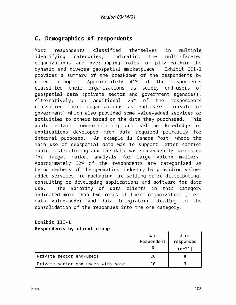
Version 03/14/01
data sets together with their own to enter new markets. They are moving, it would appear, aggressively into the provision of more products and services. New South Wales provides a more limited set of information – primarily cadastral – and does not have the same level of focus on revenue generation.
F. Australian policies, practices, and impacts
1. The policy framework
In Australia and elsewhere “there has been an increasing demand by the community, and an acknowledgment by most governments, that data about the Earth should be made more readily available to all, to enable rational debate and better decision making.”51
Australia and many other countries have tied their spatial data policy to international pronouncements. Principal 10 of the United Nations Declaration on Environment and Development (Rio de Janeiro, June 1992), stated: " ........each individual shall have appropriate access to information concerning the environment that is held by public authorities ....... and the opportunity to participate in the decision making process. States shall facilitate and encourage public awareness and participation by making information widely available." 52
Consistent with that declaration the Commonwealth, States and Territories signed an Intergovernmental Agreement on the Environment in May 1992. That agreement required the Australia New Zealand Land Information Council (ANZLIC) to "...facilitate the coordination of intergovernmental arrangements (including appropriate financial arrangements) and provide mechanisms to make the data more accessible across all levels of government and the private sector".
In the Australian context, spatial data (sometimes referred to as land information, land-related data or geographic information) are defined as “items that are described by ‘attributes’ (such as name, colour, species, or size) and located by their geographic coordinates. This definition applies to all spatial data about the Earth's surface, including marine and lower atmospheric regions. Spatial data can exist in several formats including computer-based digital data, imagery (aerial photos, satellite images) and hardcopy (maps, plans).”
51 This quote and much of the following has been taken from the web page of the Commonwealth Spatial Data Committee.
52 It should be noted that an international meeting was held on Principal 10 in the Ottawa area in late September 2000 preparatory for the next round of United Nations discussions on this topic.
kpmg 109

Version 03/14/01
The existing policy is quite clear: The Commonwealth Public Interest Spatial Data Transfer Policy was developed by the Commonwealth Spatial Data Committee (CSDC) to enable all levels of government and the general community to obtain improved access to useful geographic data owned by the Commonwealth. In summary, the policy provides for Commonwealth agencies to supply copies of nominated data sets which have previously been collected by the Government for its own purposes, at a price equal to the cost of distributing the information to users.
Although the policy is similar to that of the United States, it does not include the “exceptions” used in the U.S. to classify most data as low or no cost. The result is quite different in that the cost of distributing the information in percentage terms of their budget seems to be a much higher number in Australia. Further, there appear to be agencies which have moved far beyond this concept to recoup a far greater percentage of their operating costs than would be allowed for under this policy in the United States. West Australia, for example, recoups 71% of its total budget expenses. Further, this policy is a Commonwealth policy – it does not cover state geo-spatial data holdings. However, in this respect, ANZLIC has developed a national agreement for the transfer of land related data. The principles provide the framework for a national approach to the distribution and pricing of government spatial data. Guidelines have been formulated in each government jurisdiction, including with respect to national data bases.
The Commonwealth Public Interest Spatial Data Transfer Policy developed in 1995 is now being reviewed.53 An Interdepartmental Committee (IDC) on Spatial Data Access and Pricing has been formed in August 2000 to develop a whole-of-government policy for submission to Cabinet. The IDC is developing policy principles and considering policy options. Further meetings are scheduled with a view to producing a draft policy for submission to Cabinet by the end of 2000.54
More information will be provided on the CSDC website as it becomes available. We have been attempting to gain some insight into what may be proposed, but have been unable to do so.
The Commonwealth Spatial Data Committee (CSDC) is the peak forum for Commonwealth portfolios with interests in the collection and use of spatial data.55
It is represented on ANZLIC and supports the ANZLIC strategy to actively
53 In Australia national government activities are often referred under the term Commonwealth, as in the Commonwealth of States.
54 At the time of the writing of this report, no conclusion has yet to come about in the Australian situation.
55 The balance of the material on this topic is drawn from the CSDC web site.
kpmg 110

Version 03/14/01
encourage and facilitate the efficient and effective use of government spatial data. The CSDC has prepared the Commonwealth Public Interest Spatial Data Transfer Policy within the framework of ANZLIC's national data transfer agreement. The Policy, moving towards the US approach, permits nominated "public interest" spatial datasets (which have already been collected and funded by the Government to meet its responsibilities), to be made available at a nominal price, equal to the "average cost of transfer". An example is the National Topographic Series of Australia. "Average cost of transfer" is in effect, the cost of providing (i.e., supplying) a copy of the existing master dataset to a user - it is the cost of providing this distribution service. The actual cost will depend on factors such as the agency's distribution structure and the format in which the data is stored. The original collection costs are not included. Any upgrade or further processing of public interest data to meet specific client needs may be subject to additional charges.
The aim of the Commonwealth Policy is to maximize cost-effective use of valuable Commonwealth public interest spatial data. This recognizes that the Government has responsibilities in collecting specific data-sets to achieve government objectives, as well as a responsibility to make full and effective use of these data. The principal benefits of the Commonwealth Public Interest Spatial Data Transfer Policy are:
Maximizing use—Ready access to government data will encourage more extensive use of a valuable public resource for the benefit of the community.
Avoiding duplication—By sharing data the need for separate bodies to collect the same data will be avoided resulting in significant cost savings in data collection.
Maximized integration—By adopting common standards for the collection and transfer of data more integration of individual databases will be possible.
Custodianship—The identification of custodians for the principal datasets enable users to identify those responsible for implementing prioritized data collection programs and for developing data standards.
Better decision making—Quality information allows accountable managers to make competent decisions, avoiding large potential costs. Ready access to existing spatial data is essential for many decision making tasks such as protecting the environment, development planning, managing assets, improving living conditions, national security and controlling disasters.
kpmg 111
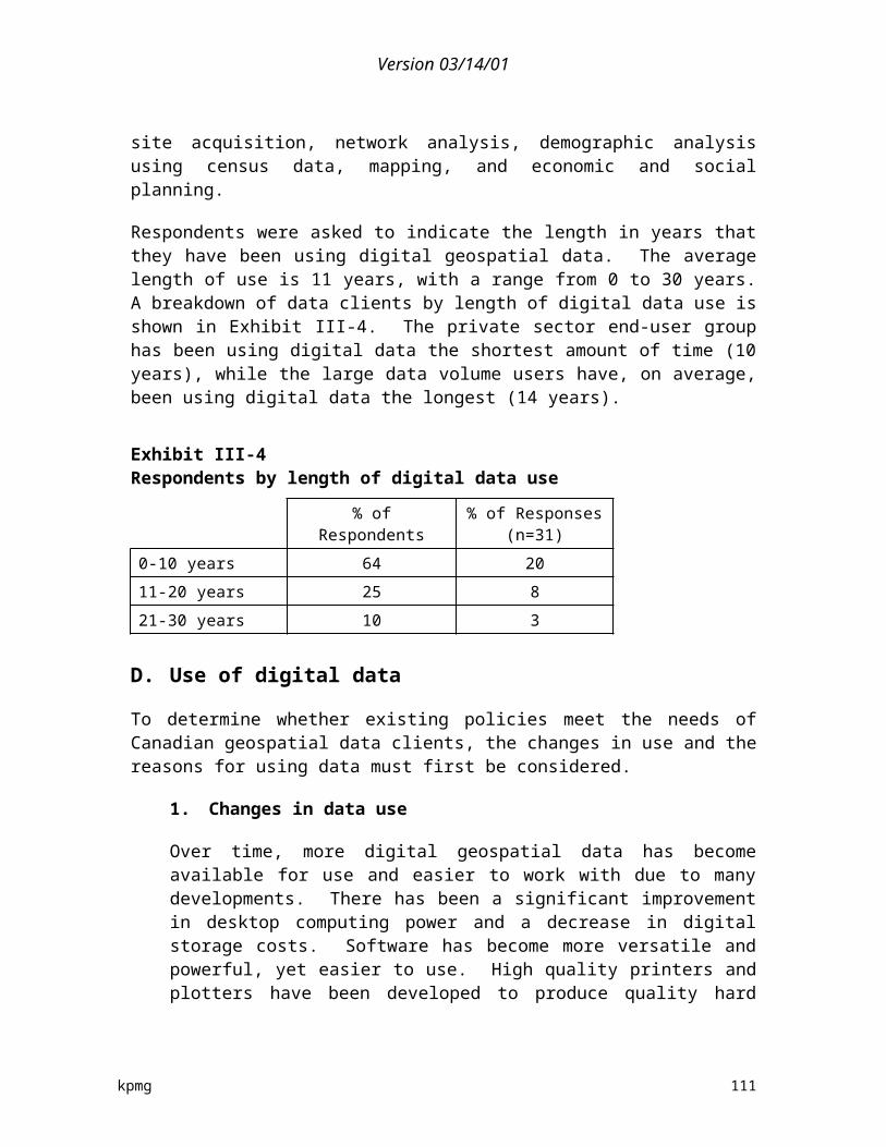
Version 03/14/01
Equity of access—A more open data transfer policy ensures better access by the whole community.
Financial implications have also been considered within the policy framework. The bulk of the cost of collecting and maintaining public-interest data is associated with meeting statutory requirements and achieving government objectives. By charging cost of transfer there should be no additional cost to the Commonwealth in supplying spatial data already collected under government-funded programs. The Commonwealth's interest in the data after transfer will be protected by a licensing agreement with each customer. The CSDC intends to regularly review the policy to consider effectiveness, efficiency and appropriateness. Such a review is now being undertaken with potentially far reach implications for how data are priced and distributed in Australia.
Cost recovery has been the subject of much discussion. Recently comments have been invited as the entire cost recovery policy of Australia is being reviewed. 56 Of the 79 submissions, a number of them are by or about agencies involved in geomatics cost recovery. Submission 7 is from Rob Gourlay, President of ERIC, a well known niche player in earth observation active across Australia and in Asia, suggests that the cost recovery policy has “stifled business growth” because of “unfair competition from government agencies who are engaged in delivery of resource information and knowledge.” Considerable detail is provided on the various tools the government uses unfairly in competing. In addition, “the high cost and limited public access for public data from information agencies” is also cited as a factor limiting his company’s growth, and that of other small & medium sized enterprises (SMEs) engaged in the information and knowledge business sectors in the new economy. Gourlay’s submission is included as Appendix H.
Another useful submission has come from AUSLIG.57 In it they review the policies under which they operate, and note that most state agencies have begun to drop prices. This 22 page document provides an excellent summary of existing state policies, as well as those in the USA, UK, and New Zealand. They note that the price for the entire data set in New Zealand is now NZ$1500, before it was over NZ$2 million. In conclusion AUSLIG suggests that the USA model of low or no prices may not be suitable for Australia in that “without adequate funding it can result in lower quality products”.
A third Submission to the Cost Recovery Policy was made by the Australian Geological Survey Organization. The AGSo was one of the organizations interviewed for this study. In their response to the interview it was noted that while
56 These are posted at http://www.pc.gov.au/inquiry/costrecovery/subs/sublist.html
57 #44 November 23
kpmg 112
Version 03/14/01
they were governed by the Commonwealth Policy, “many users would prefer lower costs for data. Variations in policy across various levels of government have led to some concern and confusion among users.” In their submission they bring out a number of important points, including the important role of information such as they provide in pre-competitive stages of resource exploration, and the important role government’s play and the benefits they derive from resource exploration and exploitation, such as economic rent. They clearly come down on the side of basic geological information being in the realm of a public good. In 1988 they began cost recovery, and by 1993 they had a 30% target, which they exceeded in 1995/96. Those activities that were for the general good were to be funded by appropriations. Those of benefit to industry were to be funded by industry. In addition it does consulting, joint ventures (JVs) and collaborative work, and commissioned work. None of this activity is covered by legislation, but rather through an agreement with the Department of Finance. In its brief, AGSO argues that cost recovery is “inappropriate” for its activities. “The government has a genuine, on-going interest in maximizing investment in the resource. The benefits are returned to the community through the discovery and development of new resources. These benefits include: resource rental tax and royalties; company tax, other secondary taxes, and income tax on employees.” A study was cited that stated that for every $1 spent by government on providing modern high quality geo-scientific data, $4 to 10$ was spent by the private sector, which in turn resulted in the discovery of new resources worth $100 to $150. Several cases studies were then cited. In one case a A$5 million three year hydro-carbon government project (the Southern Margins Frontier Project) resulted in three companies committing to a total of A$90 million over six years. In conclusion “Cost recovery from the sale of products from this project is inconsequential when compared to the investment in exploration that has been generated.”
In another case (the Broken Hill Exploration Initiative), state and Federal governments were trying to secure the long term financial security of two communities whose ore body was predicted to be exhausted in 10-12 years. After the commencement of the project the pace of exploration activity has increased “enormously so that the region is now regarded as one of the hot spots for mineral exploration activity in Australia.” Total government expenditure was A$15 to 16 million. During a time of downturn in exploration, exploration has doubled, resulting in confidence that new discoveries will result that will provide long term security. Another example of the impact of cost recovery was seen in a recent sale of product stocks at “markedly reduced” prices. 18,000 items were sold suggesting that many clients (especially in the case of smaller enterprises) would buy data could they afford it. It was noted that the SME sector had discovered half of all base metal deposits and 2/3 of all gold deposits. Anything that makes it easier for these enterprises to do exploration will lead to more success and their participation. Several state governments in Australia have been identified as providing free data
kpmg 113

Version 03/14/01
on line to encourage exploration. This would be similar to provincial and territorial governments doing this in Canada. Australia and Canada have been 1-2 in terms of amounts spent on exploration world wide for many years. This suggests that Canada should carefully track any changes in Australian policies, as they would appear to track policies in Canada.
An Australian study in the early 1990s found that use of remotely sensed data generated savings to user industries of A$4.50 for each A$1 spent on SPOT and Landsat data. This figure of 4:1 has been quoted quite widely in Australia—often erroneously in connection with the use of geomatics information.58
One interesting point made by one Australian interviewed in connection with this study is that some users do not want lower costs of data—it leads to smaller (and lower cost) competitors having equal access to information. A similar point was made in a study two years ago by a CEO of a small Canadian value-added company.
The Bureau of Rural Research has been pushed to 50% cost recovery level (it needs to recover 50% of its operating costs through revenues generated from sales of products and services). Base information is on the web site. They have followed some of Canada’s activities through exchanges. (Given Agriculture Canada’s approach, it is little wonder that they were discomfited by 50% cost recovery.)
G. New Zealand
As a response to a major economic and debt crisis, New Zealand was one of the first jurisdictions that became heavily involved in cost recovery and attempting to recoup expenses through levying charges for government information and services. It has now come full circle. New Zealand abolished all copyright fees, and charges only the avoidable cost of supply for digital topographic information, so there is no fiscal impact to Government of any customer providing a copy of the information to anyone else either in a basic or value added form. They do not seek to protect the data—they encourage its widest dissemination and use.
From their web page:
Q: "How much will the NZTopo digital 1:50,000 topographic vector database cost me?"
A: All copyright fees for the reproduction of Land Information New Zealand (LINZ)-held topographic digital data, topographic maps and aerial
58 Price Waterhouse, The Economic and Social Benefits of AUSLIG's Public Interest Program, 1992.
kpmg 114

Version 03/14/01
photographs have been abolished. The fee for the digital topographic database will only reflect the cost of its dissemination. Digital data in its raw form will cost NZ$1500 (including GST).59
H. International client comments
A small sample of US and Australian data user clients were contacted to provide their input and opinions on the data policies and practices that impact them. One dozen clients were contacted in each country, with a response rate of approximately 38% (9 respondents). While not an extensive international benchmark comparison due to the limited sample size, the findings do provide some insight from the client perspective to support the conclusions reached regarding the US and Australian geospatial environments. The analysis should not be construed to be representative for the entire client population in the US and Australia, but rather as an indication of the sample itself.
1. Overview of the findings
A summary of the comments provided from the international clients include:
Most of the data the US clients acquire is free (65%), while most of the data acquired by Australian clients are at some form of market cost (75%). Differences in the two countries’ federal cost recovery implementation and copyright legislation drives the disparity.
The international clients primarily use data for better decision making and planning, similar to Canadian clients.
With generally free and open access to federal public domain data, US users are satisfied and feel major business opportunities result. Australian clients are less satisfied with the current geospatial data environment. Lack of a national geospatial data strategy in Australia and competition by government agencies in geomatic services that are available in the private sector are believed to be detrimental to the industry and economy as a whole.
59 As was pointed out in the AUSLIG Submission on Cost Recovery, what now sells for $1500 used to sell for $2 million (and $100,000 in annual copyright fees).
kpmg 115
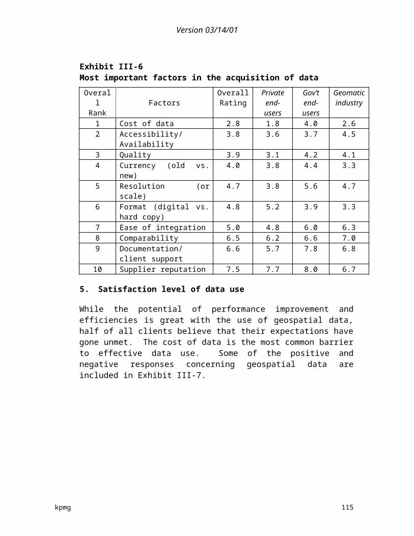
Version 03/14/01
2. Demographics of respondents
Similarly to the Canadian clients surveyed, most international respondents classified themselves in multiple identifying categories. Seven of nine respondents are value-adders, re-sellers and data application providers60, while the other two were end-users (one private sector and one public sector). The response rate for value added re-distributors and companies within the geomatics industry was much higher than their representation in the survey sample population, perhaps indicating an increased interest in providing their comments and input.
The sample is nearly evenly mixed with respondents ranging from small clients to very large users, in terms of amounts of data they purchased on an annual basis. Three respondents are small data volume purchasers (<$20,000 of data in local currency purchased annually), two are medium volume users ($20,000-50,000), and four are large volume data clients with annual purchases in excess of $50,000. The seven value-adders, re-sellers and application providers tend to be either large recipients of data (three respondents), or small data purchasers (three respondents).
Respondents were asked to indicate the proportion of their total activities in which geospatial data are involved. Overall, 87% of the international clients’ activities are tied to geospatially referenced information (higher than the Canadian clients’ results of 75%).
Respondents were asked to indicate the length in years that they have been using digital geospatial data. The average length of use (15 years) is three years more than Canadian clients (12 years). The three US respondents have an average length of use of 21 years, indicating early access to digital data and a faster adoption rate of technology.
3. Use of digital data
International data users were asked to provide information on any existing policies or practices that impaired or improved their digital geospatial data use.
60 This client group also includes organizations providing geospatial-related consulting services to clients.
kpmg 116
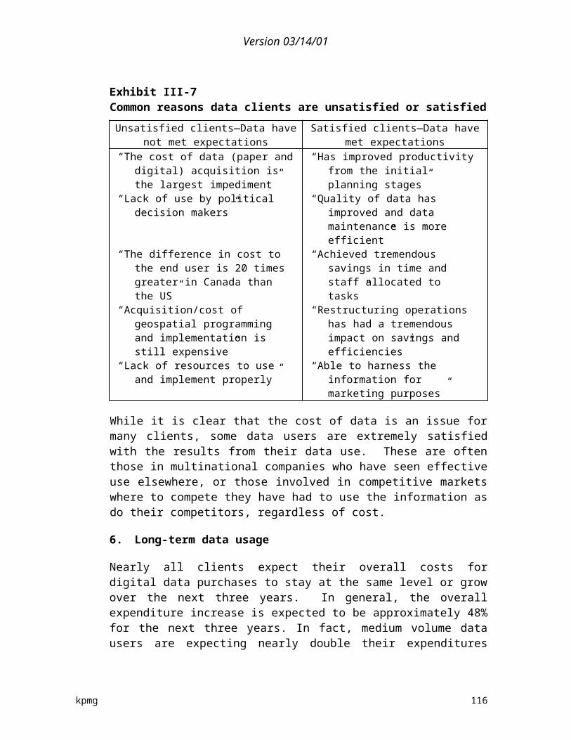
Version 03/14/01
a) Changes in data use
In the US, there has been a move away from proprietary GIS data inventory and to more commercial GIS with proprietary modelling. Value-added redistributor (VAR) data clients used to have to develop and create their own data, but now access (or purchase) data from numerous sources to provide services such as adding value, consulting, or improving the accuracy of the existing data.
In the Australian environment, there has been a shift of data use in certain industries to new applications in others (i.e., forestry and environment) as more stakeholder groups see increasing value in geospatial data. While access (due to limited public domain geospatial data and imposed limits due to price and licensing) is still restrictive to many smaller clients, advancements in software and hardware technologies are enabling new lines of business products and services to be used by a larger market.
b) Reasons for using data
Like Canadian data users, US and Australian users’ primary reason for using geospatial data is for better decision making, as shown in Exhibit IV-3. In fact, besides a small difference in the ordinal ranking of integrated planning and better resource management, all three countries had the same results, with the international clients ranking each reason with a higher relative value. The application of data for R&D and innovation was cited by two private sector clients.
Exhibit IV-3Comparison of the top five reasons for using geospatial data
International Clients Canadian Clients
Rank Reasons Importance (out of 5) Importance (out of 5)
1 Better decision making 5 4.4
2 Better resource management
4.75 4.0
3 Integrated planning 4.6 4.1
4 Improved production 4.3 3.8
5 Better marketing 4 3.4
Geospatial data is used by small organizations that could not afford to create their own data, and the geospatial data processing and analysis has provided
kpmg 117
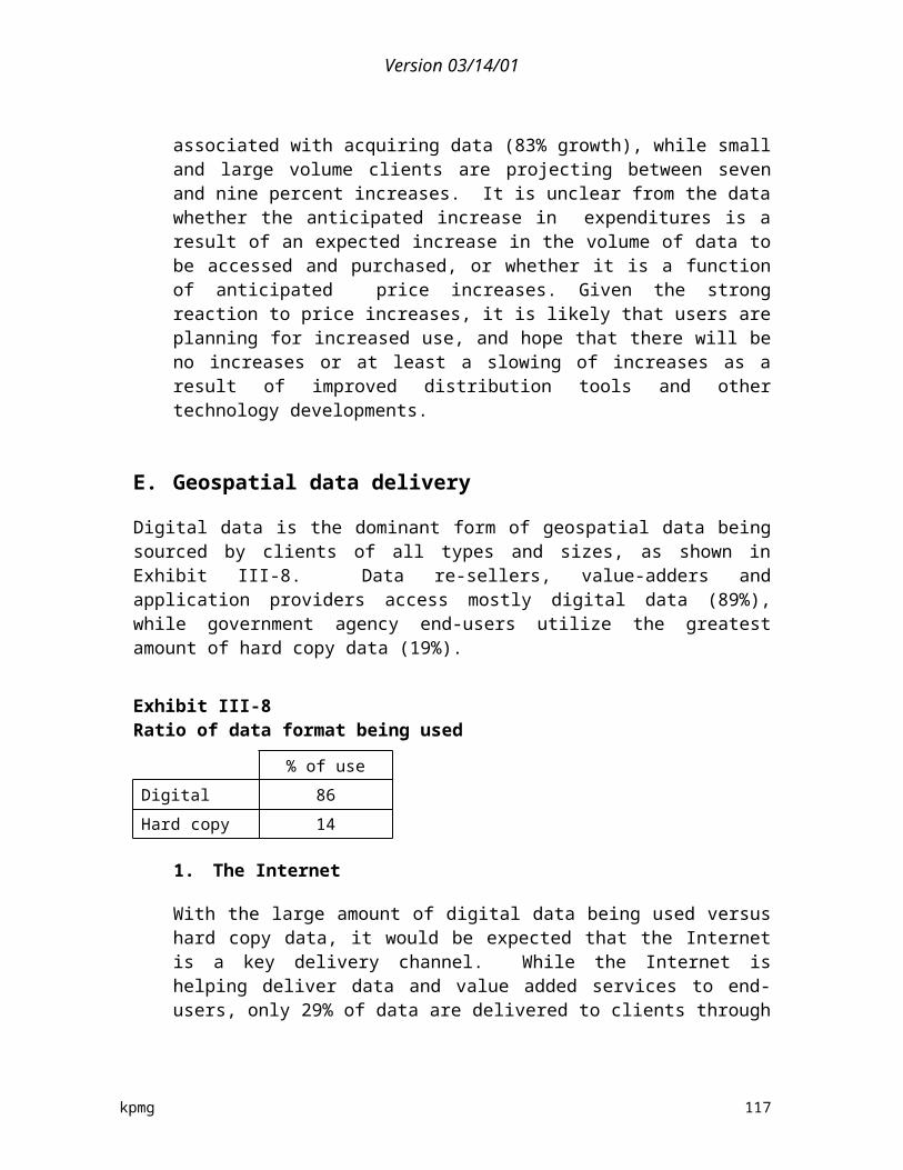
Version 03/14/01
an answer or at least verified or added to existing knowledge. Access to data has made improvements in response to the public concerning decisions being made effecting activities on State owned lands. Data saves time and is an efficient way to track and manage activities on State owned properties. The numerical processing of raster data to derive resource intelligence has been the major factor in providing efficiencies in biophysical resource feature and process mapping, field verification activities, data analysis, monitoring and reporting.
c) Factors considered in using data
Unlike Canadian data users, international clients ranked quality and accessibility as their two most important factors considered by clients in identifying and acquiring geospatial data, rather than cost of data. The highest ranked factor for each country is: quality for US clients; accessibility for Australian clients; and cost for Canadian clients. Besides a slight re-ordering in the top three factors, all other rankings are similar across the three countries, except for the US clients’ ratings for format and ease of integration (although US clients ranked these last, they are still rated with a higher value compared to the other two countries). Exhibit IV-4 provides ten factors, in order of importance, in terms of selecting and using geospatial data.
Exhibit IV-4Comparison of the most important factors in acquisition of data
OverallRank (Int’l)
FactorsTotal Inter-
national
US Rating(n=3)
AustralianRating(n=6)
CanadianRating(n=31)
1 Quality 2.9 2.3 3.2 3.92 Accessibility/Availability 3.0 3.3 2.7 3.83 Cost of data 3.7 2.7 4.2 2.74 Currency (old vs. new) 3.9 2.8 4.5 4.05 Resolution (or scale) 4.4 3.7 4.8 4.66 Format (digital vs. hard) 4.8 4.7 4.8 5.07 Ease of integration 5.3 4.7 5.7 5.18 Comparability 5.4 4.3 6.0 6.59 Documentation/client
support6.2 4.0 7.3 6.6
10 Supplier reputation 7.0 4.0 8.5 7.7
kpmg 118

Version 03/14/01
4. Geospatial data delivery
Like in Canada, digital data is the dominant form of geospatial data being sourced by international clients, as shown in Exhibit IV-5.
Exhibit IV-5Ratio of data format being used by international clients
% of use
Digital 88
Hard copy 12
a) The Internet
Based on the survey respondents, Canadian clients access the most data over the Internet (29%), followed closely by US clients (27%) and then Australian clients (8.5%). While the Australian respondents all feel their level of data access through the Internet will increase, transmission capacity/bandwidth is still limited.
b) Sources of data
The most commonly purchased data by the international users who responded are cadastral files, followed by digital elevation models and imagery/remote sensing. The data with the highest average cost per client was imagery/remote sensing. Nearly all international clients expect their overall costs for digital data purchases to grow over the next three years. The most common source of geospatial data is federal government departments (41%), with the various levels of government supplying 66% of the geospatial data used by the international clients. Exhibit IV-6 provides a summary of the percent of data being supplied by various organizations in the US and Australia. There is no significant differences in the source of data between US and Australian clients, while these clients do access more data from their federal governments (41%) then Canadian clients (32%).
kpmg 119

Version 03/14/01
Exhibit IV-6Suppliers of geospatial data in US and Australia
% of data
Federal Government 41
Provincial Government 20
Private sector – data creator 6
Municipal Government 5
Private sector – re-seller 9
Other sources 9
c) Data supply experiences from other countries
As shown in Exhibit IV-6, US and Australian clients receive 9% of their geospatial data from other sources (twice as much as Canadian clients). In fact, approximately 40% of the international clients have sourced data from other countries. These data are from countries including Canada, Mexico, Thailand, China, and from such agencies as EROS, EOSAT, RADARSAT International, EUROIMAGE, and SPACEIMAGING. Most reported no major problems, and stated that benefits include some sources with free and easy access to on-line data catalogues. Comments from US clients regarding Canadian data sources can be summarized in the following two quotes:
“Canadian geomatic agencies have a nice on-line ordering / delivery system, but the data costs are too high.”
“Canadian data is too expensive to be a source for many of our clients.”
5. Price of data
Nearly two-thirds of the data (65%) used by US clients is accessed free of charge, while only a quarter (25%) is purchased at market price. The opposite is the case for Australian clients, where only 15% is free of charge and 75% is at market price. Large international clients paid market prices for most of their data (83%). Exhibit IV-7 shows the distribution of data used by US and Australian clients along the “fee or free” price spectrum, and includes Canadian client results for comparison. Market cost includes any price believed to be higher than nuisance or cost of reproduction (this would include cost recovery, price points set based on market/demand factors, etc.).These results confirm findings from other phases of this study.
kpmg 120

Version 03/14/01
Exhibit IV-7Comparison of the volume of data used, by cost
25%
57%
75%10%
21%
10%
65%
22%15%
0%
20%
40%
60%
80%
100%
US Canada Australia
% o
f Dat
a A
cqui
red
Free
Nominal Cost
Market Cost
From the perspective of the Australian clients, nearly all of their public sector geospatial data suppliers’ pricing approach is to provide data at market cost. This is opposite to the US where major government data suppliers provide free access.
6. Government policy impediments
US data clients have very little negative comments with regard to any government policies that restrict or hinder their use and application of geospatial data. One client feels that the cost of data minimal and below what it would cost to reproduce the data in house. Another example includes a state government that places all public domain data on their web site for downloading at no cost, however all hard copy maps produced are subject to a cost recovery fee according to size of map produced. There are no licensing restrictions on this public domain data. One US client commented that Canadian data is very expensive, but needed for strategic planning purposes so the firm must pay grudgingly.
Australian data users have mixed comments regarding their government’s policies. While a few mention that they have faced little impediments due to the policies and practices, others are more verbal in their dissatisfaction. Typical comments are:
“Cost recovery policy in Western Australia does limit use of the data.”
“All satellite and digital data products have copyright and all are different.”
kpmg 121

Version 03/14/01
“The federal and state government agencies are the greatest competitors for work. They compete unfairly on price, have free access to public data that is charged to industry and withhold public knowledge for their own commercial benefit.” As well, “This competition is often unfair as much of their work is no longer research but application work.”
“The price of public data is too high and stifles business growth.”
“It is the conditions set by the satellite operators which hinder sales.”
“Business growth requires free access to public data to promote fair competition, and support for R&D and innovation.”
7. Price sensitivity
The US clients indicated a modest level of price sensitivity. Many rural organizations are unable to afford data that has a cost and also budget to have value added. Larger organizations have data needs that exceed the available data resolution. Due to legislation like the Open Records Act, the US public can generally access data from state or national public agency for free.
The Australian clients indicated a fairly high level of price sensitivity and therefore any price variation has a great effect on level of use. One VAR indicates that most of their clients are very price sensitive. The firm would definitely have more clients willing to use remote sensing services if data prices were more reasonable. Another Australian user believes free access to public data enables greater penetration into potential markets and encourages R&D and innovation, and that Data price is the most limiting factor in expanding service delivery and marketing.
8. Impact of freer data access on business growth and opportunities
US clients were asked to what extent they believed their organization had more major business opportunities due to generally open and free US data. For a governmental agency end-user, use of USGS digital maps and other public domain data is a key part of their planning and execution of mandated services to the taxpayer. For a US end-user, free or near free data from federal and state governments has altered the way they make decisions, and is changing business processes. There is currently a dependency and expectation for free / near free data now. A US VAR believes that small industries, cities and rural counties would not become involved in GIS if not for the availability of free or reasonably priced geospatial data. They cannot afford the cost of both purchasing data and adding value.
kpmg 122
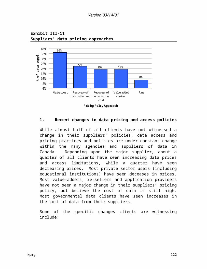
Version 03/14/01
9. Client comments on geospatial data policies
US data clients believe that national government data pricing is very reasonable and makes the data accessible by all organizations. However, national and state pricing policy needs to be aligned, and the national government needs to continue the efforts to see that there is funding for the state and local governments to update and maintain data and make it available to the public at a minimal cost.
Australian clients believe that there is a general lack of a consolidated national data pricing policy and that this impedes against competitive neutrality, industry growth and innovation. Competition on projects by federal and state government departments in Australia, which purchase their data at discounted prices, make it very difficult for the geomatic industry in Australia to grow and prosper.
10. Suggested changes
International data users proposed a few suggestions regarding potential changes to their local geospatial policies and practices. The overriding comment was that data produced by governmental agencies in the conduct of their mandate should make these data available for free or at cost of reproduction, possibly through a private sector contractor.
Other recommendations include more emphasis on geospatial data awareness and training for both educators and students; completely outsourcing the management and supply of the digital data to the local geomatics industry; restricting government agencies from providing competitive value-added services available in the geomatics industry; and increased public investment into private industry R&D and innovation with spatial data. Governments should redirect public capital invested into spatial data service delivery activities into public data capture and maintenance and distribution.
Data needs to be recognized as an important public asset. There will be an upfront cost for promoting and educating teachers in the use of geospatial data in the classroom, but this will set the stage for students to use, create and distribute more data in the future. State and federal agencies would have to make sure there is funding allocated to develop and maintain spatial information that is important to the mandates, as well as the public.
kpmg 123

Version 03/14/01
V
Summary And Recommendations
This chapter provides a summary of the key findings concerning the pricing and licensing policies of existing agencies and the impact of those policies. The chapter also provides a list of suggested recommendations to address the current deficiencies in Canadian geospatial data policy and practices for the future with respect to pricing and licensing policies. Finally, it discusses other steps that would appear appropriate based on the findings of the study (although largely outside the mandate).
A. Pricing strategy decision factors
A number of factors have influenced the pricing strategies adopted by various agencies. Among the key considerations have been:
Central Agency Policy—A number of government central agencies have adopted general policies on the pricing of government services that have affected the approach taken by particular agencies. The federal Treasury Board policies are a clear example, generally encouraging either recovery of the full cost of distribution and/or the value added pricing model. The recent decision within the Province of British Columbia preventing inter-agency charges is another. In turn, these central agency policies are generally based on the other considerations discussed below.
Public Benefit—Some agencies have considered their data to be supportive of a public good, by encouraging economic activity or effective social or environmental planning. This generally encourages a free or nuisance fee approach to pricing.
Private Benefit—Some data is considered to contribute primarily to a private benefit to a particular consumer or group of consumers. Information collected exclusively for a particular client is the clearest example, but cadastral data including property descriptions and ownership/interest registrations is also in this category. Some pricing decisions attempt to allocate costs based on the perceived private versus public benefit. Value added pricing is an attempt to capture the private benefit added to “public” data.
kpmg 124
Version 03/14/01
Sunk Cost—Data that is collected at public cost by a government in order to meet its own decision and operational requirements is considered by some to be “paid for” by “public” dollars. The extension of the argument is that the data should be available without additional cost (not “paid for twice”), whether by the public or by other agencies within the government. The BC government decision not to allow charges between agencies reflects this approach, and the federal approach limiting charges to the full cost of distribution (and not data collection or maintenance costs) is another reflection of this principle. Some industry or public members take this theory to conclude that all data, once collected, should be free to all, without concern for costs of distribution.
B. Current pricing practices
The various pricing principles have led different geospatial data agencies to employ a variety of pricing approaches for their digital data:
Free—Some agencies distribute their data freely, generally using the Internet. This approach is frequently adopted when use of the data is encouraged to promote better decision-making, whether in the public or private sectors, to achieve economic development, social or environmental goals (a “public good”).
Cost of Duplication—Some agencies charge only the cost of duplicating and providing the data. In some cases this simply covers the cost of the media; in other cases some allowance is made for the staff costs in carrying out the duplication. In either case, the costs tend to be minimal, similar to the “nuisance fee” approach and can simply be a way of marketing the need for a nuisance fee.
Nuisance Fees—Some agencies charge modest fees, intended only to limit demand to users with an actual need or use for the data, eliminating trivial requests, or requiring users to define clearly the data they actually require. This approach generally applies in circumstances where data files must be custom prepared and/or the data distributed on a physical medium – rather than through the Internet.
Recovery of Full Distribution Costs—This approach is the one generally promoted within the federal agencies, and is generally applied to mean recovering the entire cost of creating the capacity to distribute data, and can include file preparation, marketing, infrastructure (Web sites, servers, duplication infrastructure and associated staff) and actual duplication and distribution costs. The cost of data collection and maintenance is excluded. The result can be fees that are quite material, and the approach often involves licensing to limit the further distribution of data (in order to retain markets for cost recovery) or
kpmg 125
Version 03/14/01
requiring royalty payments from further distribution. This approach is generally applied to most of the framework map data prepared by federal agencies.
Value Added Pricing—A number of agencies will conduct data manipulation or extraction activities to provide data more suited to a particular client’s needs, and they charge (generally based on an hourly rate for staff time) the client the perceived value of the “value added” activities.
Full Cost Recovery—Full cost recovery (including the costs of data collection and maintenance) is generally limited to two circumstances: 1) data collected for the express purpose of satisfying a client request (i.e., satellite data); and, 2) and cadastral and/or municipal assessment data which is created to support specific client needs with significant financial implications (prove interests in property or facilitate property tax processes).
Market Price—Relatively little data is distributed based on a “market” price, but some agencies have adjusted their prices in response to market influences, generally by lowering the price.
While these are guiding principles to pricing practices, some agencies or levels of government utilize hybrid models—for example in BC, all data distributed to other BC public agencies are provided free of cost, while data provided to any other clients, including other levels of government, are supplied with partial cost recovery prices.
C. Current licensing and royalty strategies
Licensing requirements, including the requirement for royalty payments by subsequent users as appropriate are being used with increasing frequency to achieve a range of goals:
Revenue Protection—Is a frequent goal, prohibiting the redistribution of priced products in order to require all users to contribute to the cost recovery objectives. In these cases, licenses either prohibit redistribution of the data or require royalty collection as part of the redistribution. Agreements may also limit the use of the data to a location, individual user(s) or computers in an attempt to capture increased revenues from larger or multi-site organizations.
Quality Preservation—Is achieved by licensing restrictions on the alteration of the data.
Promotion—Some agencies have engaged private sector organizations to market their data, encouraging broader use of the data, using the licensing restrictions to protect the revenue of the private sector partner.
kpmg 126
Version 03/14/01
Recognition—Although licensing is a way of ensuring adequate recognition of an agency contribution to data, this does not appear to be a prime motivator of licensing initiatives.
D. Privacy issues
Increasingly stringent regulations related to the privacy of personal information are restricting the accessibility of some data. While income tax records and census results have always been protected at the individual record level, there are increasing restrictions to individual records or parts of records generally associated with data such as cadastral and assessment records. This, in turn, requires a greater agency stewardship and data custodian component as agencies strip data elements or aggregate data to meet privacy requirements. On the other hand, numerous challenges have been launched through the Freedom of Information act to access data held by government agencies.
E. Unintended outcomes of current approaches
The current pricing and licensing approaches have a number of unintended and generally negative outcomes, which led to the requirement for the conduct of the present study. These outcomes include: The cost of framework data has resulted in many agencies ignoring available data and creating their own, or manipulating or degrading the data to avoid licensing/royalty restrictions. The problem is most apparent with federal agency framework data, and the agencies affected are at all levels of government.
Many pricing policies are inconsistent in their implementation across agencies in the same level of government, or even within the same departments. Many policies have competing priorities.
Decisions are taken without using the best available data because the cost of the data exceeds budgets and/or perceived value. At the extreme, this occurs between government agencies, with one agency using inferior or no data when another agency in the same government has the data. In other instances, effective, timely and economic decision-making is hindered by licensing conditions such as site licensing or machine-specific licenses. The outcome is inferior decision-making in both the public and private sectors.
Some agencies are unable to distribute their own data to the public, or are required to attach prices to the distribution of their data which they would otherwise make available at no cost in order to respect the licensing and royalty practices of agencies that have provided some part of their data.
kpmg 127

Version 03/14/01
Access to data for education purposes is limited and some Canadian educators are now using irrelevant US data in their educational programs because of the high cost of Canadian data.
The efforts to avoid paying for federal framework data has resulted in other agencies (at all levels of government) developing their own data on a basis inconsistent with each other and inconsistent with the federal framework maps, making data exchange and integration more difficult.
Once cost-recovery has been implemented, departments and agencies find it nearly impossible to change things. This is despite the fact that the federal TB cost recovery policy instructs departments and agencies to evaluate, assess and review policies on a regular basis. In addition, it can be argued that new technology and expectations driven by the Internet and more-citizen centric service delivery pressure agencies to behave differently, yet the cost recovery regime leaves little room to achieve this.
Cost recovery has helped make departments and agencies more-business like, but this may have come at the expense of public good interests. It can argued that it has 'narrowed' interests and service delivery, with many departments putting more and more emphasis on cost recovery operation rather than general or public good services. For example, it is not uncommon for managers/programs to have the choice between providing more resources into services to the general public, say free on the Internet, versus putting more resources into advertising and promotion of products that generate revenues that can be retained.
There are unclear definitions and roles regarding the government’s role in providing “value-added” services. Many in the geospatial industry believe the private sector firms have been negatively impacted in their growth by competition from government agencies providing “value added” services. It should be noted however, in an earlier study done by GIAC, private sector opinion was mixed regarding the issue of government intervention through the production of geospatial data products. As well, within government, there are existing geospatial products that cost more than comparable private-sector products, but there are some that cost less.
The geospatial industry in Canada is believed to have not developed as quickly as in the United States with regards to the development of data manipulation tools and programs, partially as a result of initial costs of data, royalty payments, and the restrictions on distributing data.
kpmg 128

Version 03/14/01
F. Optimal policy directions within a changing environment
When first introduced, cost recovery policies addressed the present socio-economic and political environments at the time. However, it is clear that the environment in which cost recovery was first established has changed in many ways. Numerous drivers of change in the public and private geospatial sectors include:
The emergence of the Internet and subsequent growth of adequate bandwidth. This has enabled larger and more detailed digital geospatial data files to be transmitted across any distance instantaneously within a secure channel. As well, sharing of data can become more distributed, cost-effective and ubiquitous.
Interdependent with the Internet, there has been an increase in availability of digital data sets. Digital data files allow a reduction in the reproduction costs on a per file basis, and enable improved distribution over hardcopy forms of geospatial data sets.
There has been an increased recognition of geospatially referenced data in decision making and planning. More and more industries and client segments are recognizing the importance of integrating accurate geospatial data into strategic and tactic decisions—whether they be policy or commercial related.
More educational institutions, from elementary school to colleges and universities, are searching for more accessible and cheaper geospatial data to use in teaching and research. These students will become the nation’s workforce in the future and their skills, local knowledge and awareness of geospatial activities need attention.
Speed of business seems to be increasing at a faster and faster pace. Firms no longer have the luxury of waiting for complex, expensive and bureaucratic licensing and contract negotiations.
An overriding driver is the globalization of trade and the reduction of trade barriers, and with it, the increased international competition within the geomatics industry. Canadian geomatics and GIS firms are now forced to compete with American, Australian, European and Asian companies in the supply, analysis and value-added goods and services production. While this creates more international opportunities, it also has increased local competition. Many Canadian firms believe they are uncompetitive due to the relative lack of data available, primarily due to cost recovery pricing of government data suppliers.
As part of the federal TBS policy, requirements specify that the role of policy needs to be reviewed as a relevant part of the process of managing the role of government across time, and within the context of advances in technology and business processes. Due to
kpmg 129

Version 03/14/01
the changes and drivers listed above, it seems only natural that the cost recovery policy be re-visited.
This study has found that most active players within the geospatial industry, in the academic, private and public sectors, have expressed an openness and desire for change. Within the context of this changing environment, prevailing governmental geospatial data policies and practices, especially at the federal level, should strive to address a number of goals:
First, the overall purpose should be to promote the development of economic, social and environmental wealth in Canada. This is achieved through increased effective use of geospatial data in analysis and decision making processes in all areas of the economy, and in all levels of government.
The second purpose of any policy changes should be to increase access to and use of geospatial data and improve sharing amongst holders of data, at each of the three levels of government. Data sets need to be based on collective standards. Access and use are improved by reducing barriers—conflicting standards, high data prices, restrictive licensing policies, detailed negotiation processes and limited data access points.
Third, policies should attempt to develop the global competitiveness of the Canadian Geomatics industry, to any extent possible. A strong and competitive local industry will increase development of value-added geospatial data products, as well as related software and hardware technology, and thereby create economic value for the country. Policy directions addressing industry competitiveness must be done so in a manner that represents “fairness” to taxpayers—that is, policies should note favour the industry over others or provide the industry with undo benefits at the expense of taxpayers. Nonetheless, the general price-point for geospatial data could be reduced by minimizing distribution costs and reducing licensing and royalty restrictions.
Fourth, policies and practices should continue to embrace client-focused and responsiveness principles. Policies should continue to encourage a “business-like” mind-set within departments in terms of efficiencies, recognition of government’s role in geospatial data supply, internal resource utilization and planning for product/service offerings. These positive outcomes and incentives of the current data access and distribution policies should be maintained in any new policy directions. While cost recovery was one driver to assist in the effective allocation of resources within government agencies, other incentives and concepts should be explored to mitigate some of the policy’s negative outcomes.
Based on the recent changes in the local and international environment, as well as the optimal policy directions, the following recommendations have been proposed.
kpmg 130

Version 03/14/01
G. Proposed recommendations
The following recommendations are based on the integration of the study findings and numerous interviews and discussions with geospatial experts. They are being proposed to address the various issues and unintended outcomes of Canada’s very complex geospatial policy environment. Many of the current government-driven pricing principles and strategies remain valid, but must be implemented in a manner that minimizes unintended outcomes and contributes to the economic, social and environmental wealth of Canada, including but not limited to the country’s geospatial industry. These recommendations are generally meant to address geospatial data originating from agencies in all three levels of government.
Recommendation 1: Data Accessibility
A large component of geospatial data sets supplied by government can be considered a public good with many positive externalities and benefits. In general, it is believed that the more data that are available to the public, the more they will be used for decision making and policy planning. This intrinsically leads to improved resource utilization, increased efficiencies, and larger socio-economic returns. For example, delivery of more effective and efficient public services in health, education, and criminal justice can be achieved partially through the integration of demographic and geospatial analysis into planning. As another example, Canada can achieve a leading role in environmental management and wetlands conservation through increased access to geospatial data that enables collaboration between pollution monitoring, fisheries habitat, soil/vegetation composition, and forestry resources.
Recommendation—Geospatial data that are collected or created by any level of government should be made as readily available to the public as possible by improving access mechanisms and processes, unless there are privacy, security or competitive reasons not to do so.
Recommendation 2: Core Framework Data
Framework map data, particularly the geo-reference and topographical framework maps, is used as the underlay for thematic data and provides the basis for many geospatial data sets used by public and private industry. Due to the nature of the data itself, most of the framework data sets can be considered as lumpy, non-rival, non-excludable goods—that is, there is a large sunk cost to develop the data, very low marginal costs to supply one more additional copy once its been processed, and generally public-oriented data.
Cost recovery policies encouraged a client-focused and internal efficiency approach to supplying core framework data—these management paradigms must continue,
kpmg 131
Version 03/14/01
but the data has become less accessible primarily due to prices charged for these data. Enabling increased access to this core data drives the use of data in decision making. Departments and private sector clients dealing primarily with specific thematic data layers need readily accessible and accurate core framework data to provide the base for their thematic layers to be applied to. Due to their nature as an underlay, framework data are generally easy to place near the “public good” end of the public versus private spectrum, related to say infrastructure.
Recommendation—Core framework data, particularly the geo-reference and topographical framework maps used as the underlay for thematic data, should be provided free as a public good (or more properly, licensed at no cost), to encourage use, standardization, and consistency amongst all client groups. In making this data more accessible, efforts should be made to keep distribution costs to a minimum, however, additional A-base funding may be required.
Recommendation 3: Thematic Data
Thematic data represent a key component of many geospatial data products and services. Thematic data are used in a variety of industries and sectors. Frequently, clients request specific types of thematic data to fulfil a decision-making or planning process requirement, which requires in some cases substantial amounts of funding to research, collect and maintain the data sets. This creates an excludable good (i.e., non-public due to its specialization). This situation puts some thematic data closer to the “private benefit” end of the public versus private spectrum, in which case cost recovery can easily be applied. If a client requests that new thematic data be supplied, outside of data already being collected for an agency’s mandate, it seems reasonable for an appropriate cost-sharing agreement to be established.
Recommendation—Where costs are material and exceed the “public good” of encouraging their use, costs should be borne by those seeking the data. Notwithstanding, the cost of making data available should be minimized as much as possible. Specifically, in implementation, the following points should be taken into consideration:
• Expand distribution of thematic data via the Internet, possibly by providing some dedicated marketing and distribution A-base funds to expand “GeoGratis” or a similar focal point for free data distribution.
• Utilize “nuisance fees” for non-Internet distribution (i.e., CD-ROM, paper), to encourage use of digital distribution and to recoup easily quantifiable hard-copy reproduction and media expenses.
kpmg 132

Version 03/14/01
• Restrictions on redistribution should be eliminated—except where commercial data is used within government.
Recommendation 4: Cadastral data/process
Most cadastral and property assessment systems utilize significant fee-based data pricing approaches. Cadastral systems generate most of their revenues from the transaction fees which both record an individual’s (or firm’s) interest in property, and generate the new data required to maintain currency. The assessment systems tend to be co-operative-like, with the municipalities that require the assessment data paying the costs of developing and maintaining data.
Much of the data are covered by privacy restrictions, and its distribution are either prohibited or restricted to “value-added” processed data. Some form of pricing or nuisance fees will continue to be an important element of containing demand on governmental cadastral data resources, especially at the provincial and municipal levels.
Recommendation—Transaction fees should remain an appropriate mechanism for cadastral data systems at the provincial and municipal levels. This includes “registered user” connections and access charges. However, efforts should be made to implement unrestricted integration with municipal / assessment databases.
Recommendation 5: Copyright and Licensing
A marked difference between the digital data policies and practices between Canada and the US at the national level is the Crown copyright requirements. These requirements, coupled with complex licensing agreements, limit the broader use of geospatial data in Canada when compared to the US by preventing redistribution, whether its within or between organizations. The use of licensing and copyright to prevent redistribution (i.e., to protect pricing policies) inherently contradicts the goals of maximizing data use and the resulting benefits, and therefore should be minimized.
Instead of preventing data use, licensing and copyright should be used to protect data integrity, essentially building a “branding” that can be recognized as a mark of quality data (especially for framework data required to facilitate data integration). This is only effective as long as the data are considered to have integrity and relevance (i.e., currency), which will require additional data collection and maintenance investments in some cases. For example, a data agency supplies an original data product and retains the sole source of the data while providing their branding to the file/product once a data set has been distributed to a user. That user may be allowed to post the same data file for free on its own website for others to
kpmg 133
Version 03/14/01
access, but only if the brand remains intact. In this instance, much of the distribution effort and cost is transferred to other users.
To ensure the branding is effective, collaboration with VARs and distributors should strive to have them recognize the original data source as part of the copyright. This will help in addressing the branding, providing a level playing field and visibility to public sector investments.
Recommendation—Use copyright and licensing within Canada to protect quality of geospatial data originating from all government agencies, particularly at the federal level, rather than to prevent use. Most data should be licensed at no cost to users. “Branding” of the original source data would facilitate re-use by retaining the “brand name” as long as the original data is not modified.
Recommendation 6: Inter-governmental data sharing
Governmental departments make up the single largest user group of geospatial data in Canada. The study found that many of these governmental clients in some cases cannot use needed data to make a planning or policy decision due to the costs being charged by another government agency through cost recovery. There are the positive externalities (social, economic and environmental) that can arise from effective geospatial data use in government policy planning, as well as important social and political objectives. The potential opportunity cost in public policy planning can range from inadequate fishery habitat management to inefficient social or education program development.
Clearly, due to limited funding, data agencies should be free to enter into cost sharing arrangements with other government agencies to allow the collection of new data / preparation of new products. However once that data exists, the agencies should make them available to all other government departments, at all levels, without charge to maximize the use/benefit from the data/product. This spirit of sharing needs to be encouraged and will require incentives to participate—a clearly defined data collection responsibility framework is one step (i.e., which level or agency will collect what data and to what resolution, etc.), requiring reciprocal participation and national uniform data standards are others. The potential disincentive of waiting for other agencies to spend their resources and create needed data must be mitigated and the feedback loop from users must be maintained. The “BC provincial model” for data sharing is one current example that can be analyzed.
Recommendation—Develop an inter-governmental data sharing policy model which would encourage and allow the free exchange and sharing of geospatial data from data agencies with other government departments and with other levels of government.
kpmg 134

Version 03/14/01
Recommendation 7: “Value-added” services
Beyond the provision of data gathered in the conduct of an agency’s mandate, various activities can be applied to the data on a customer’s behalf to create increased value for the client. By its nature, customized data is excludable (non-public due to its specialization and direct private benefits) and therefore more open to user charges. In most cases, the cost of providing these “value added services”, such as custom data tabulation, manipulation or analysis, can and should be recovered from clients requesting the services.61 Technology, including hardware and software applications, have allowed the increased opportunity to provide these value added services with fewer resources. While departments may be providing more data for free (or without a licensing cost), they could develop models/approaches to charge for reasonable additional services, such as after-sales client support. However, government agencies should limit their involvement in the provision of value added services to circumstances where the private sector cannot provide the service, generally because of privacy concerns related to the processing of individual data records (i.e., statistical data).
Recommendation—Reasonable direct costs can and should be recovered from clients (public and private sectors) when a government data agency applies some form of “value added” service to its data.
• It should be noted however, that government intervention and supply of value-added products/services, beyond the mandates of the data agencies, should be limited to instances where the private sector cannot provide them due to economic reasons or privacy concerns.
H. Implications and corollary actions
It is suggested that the preceding recommendations are implemented as swiftly as reasonable possible. GeoConnections and other initiatives are already under way and represent feasible avenues for further on-going collaboration to include private industry in driving changes. This section examines the more specific actions key actors and the federal, provincial and municipal levels would have to take to implement these recommendations, and identifies some of the implications for particular types of agencies.
61 Acting as a custodian or steward of digital data (i.e., data maintenance, verifying accuracy, data file cleaning, activities required to prepare a data set for distribution etc.) that is within an agency’s mandate or normal course of activity should not generally by considered as value added services.
kpmg 135

Version 03/14/01
1. Federal
The implementation of the proposed approach would result in decreased revenues for some federal agencies. However as indicated in Exhibit V-1, the fee revenue, after considering the costs of data distribution, comprises a relatively small portion of most agency budgets, and in most cases does not cover the full cost of disseminating data. The key to being able to absorb reduced income is to reduce the costs incurred in marketing and distributing data.
Exhibit V-1Cost of distribution versus fees collected for federal agencies
Typical Agency Type Cost of data dissemination62
Fees generated63
Net FeeImpact on budget
Federal Framework 14.5% 13% -1.5%Federal Thematic 10% 7.5% -2.5%Overall Federal (average) 10.5% 10.5% 0%
A number of approaches are possible. Distribution through the Internet reduces the cost of the second and subsequent copies distributed, but still leaves agencies with the cost of establishing and maintaining an effective site. Mandating one agency with the responsibility of facilitating web-based access would reduce duplication of effort and provide a clear indication of the cost and accountability for wide-spread public access to data, likely a defensible and supportable mandate in A-base funding negotiations. This central facilitating body would not control data or its access, but would be established to assist data producing agencies in expanding distribution of their data. While this could be a federally-led effort, provincial agencies need to be integrated and involved in establishing the model. There are currently a number of partnership arrangements being orchestrated under GeoConnections regarding this issue.
The second approach suggested is simply the removal of restrictions on redistribution. The agency may then retain a fee to make the first copy available, but further distribution can be free (i.e., if an association makes the purchase and distributes to its members) or at a reduced cost (i.e., a value-adder incorporates the data into a product, or a private sector reseller chooses to promote and distribute the product).
62 Cost of data dissemination includes costs related to data distribution, marketing, fee collection, sales support, and a portion of overhead expenses.
63 While the survey asked for the fees generated from digital geospatial data sales, a small amount of the revenue reported may be from geospatial data derived from value-added services.
kpmg 136

Version 03/14/01
However, there would still be a reduced net budget for some agencies which can be a more significant issue for some than for others. This could require reductions in operating costs beyond the data distribution costs, or additional A-base funding. It should be noted, however, that the costs of data collection and maintenance are, by definition, not covered by cost recovery fees in federal agencies. Given that data collection and maintenance funding is inadequate in most agencies, the recommended approach will not resolve this issue either, although the wider and more effective use of agency data may make a more compelling argument for increased funding.
There may be some need to stage implementation of revised approaches in order to:
Respect existing agreement and arrangements with data distribution and other partners.
Co-ordinate with growing Internet capability.
Accommodate the time required to change agency asset utilization and development of capacity within the private sector.
a) Framework data
The federal government could have an important role in providing the framework data, maps, systems and standards required to maximize the usefulness of data collected by all levels of government in Canada, and indeed by the private sector. Properly carried out, this mandate would lead to consistent, compatible and interoperable data sets. The current pricing and licensing practices of the agencies involved have prevented this from occurring with the result that almost all municipal, most provincial and even some federal agencies spend some level of funds to develop duplicate data, often at a higher resolution. These agencies should move quickly to make their data available as widely as possible and move to develop standards, policies and approaches that meet the needs of all three levels of government as quickly as possible. The alternative will be the continued development of a number of independent inconsistent approaches across the country.
b) Licensing principles/approaches
The U.S. practice of making this data available freely has helped promote a rapidly growing geomatics industry, but the lack of standards has resulted in many users changing the data to suit their own needs, leading back to a series of incompatible data sets. Federal agencies should consider using the copyright and licensing approach to limit this outcome, “branding” its original data and allowing anyone to re-use the original data with whatever overlays
kpmg 137
Version 03/14/01
may be appropriate and retain the “brand name” as long as the original data is not modified. This approach will only be effective as long as the federal data is considered to have integrity and relevance (i.e., currency), which will require additional data collection and maintenance investments in some cases. It would also be possible to establish a process to review suggested data modifications from users or resellers who wanted to improve the data but retain the brand.
c) Education uses
The recommendations contained in this report should allow adequate data access for educational users. However if they are not implemented broadly, particular initiatives will be required to encourage and assist Canadian educators to nurture "geospatially literate" graduates which will in turn help develop the Canadian GIS industry. Both the prices and the licensing restrictions (multiple users/sites, etc.) reduce the ease of access of educators to Canadian data to develop the necessary spatial awareness to make effective use of the data.
2. Provincial
The are many more provincial agencies where the reduction or elimination of user fees will have substantial impact. However the most significant fee-based systems are the cadastral and property assessment systems where continued fees are consistent with the recommended approaches. Cadastral systems generate most of their revenues from the transaction fees which both record an individual’s (or firm’s) interest in property, and generate the new data required to maintain currency. The assessment systems tend to be co-operative-like, with the municipalities that require the assessment data paying the costs of developing and maintaining data. These approaches should continue. The area that could be affected is the subsequent distribution of the data. Much of the data is covered by privacy restrictions, and its distribution is either prohibited or restricted to “value-added” processed data for which fees continue to be appropriate. However the balance of the data, particularly the map elements, should be treated as framework data and made available with as little cost as possible. Restrictions on redistribution of data, particularly by municipalities where the property descriptions are a key element of municipal policy and technical discussions, are counterproductive and should be removed.
Provincial agencies developing other framework map (primarily topographical) and thematic information apply a wide range of pricing regimes and some will have budget implications from adopting the approaches recommended. In addition, provinces often require higher resolution data that is not available from the federal government. However in many cases the provinces and their municipalities have
kpmg 138

Version 03/14/01
developed data sharing regimes which effectively combine the Geospatial data resources of the two levels of government in order to provide an efficient and quality service to most key users (other than the federal government). The B.C. experience demonstrates the importance of inter-agency data sales, however, and the fact that elimination of fees will not result in extensive increases in net cost to the taxpayer, just a requirement to shift budgets between the “user” agencies and the central data providers.
3. Municipal
Municipalities provide an interesting case study for fee systems. Many of these municipalities have established carefully justified fee schedules for geospatial data, and in some cases intricate licensing requirements to contain or control data redistribution or use, yet none of them have significant fee revenues. The outcome of the policies is largely to prevent the distribution and use of the data and the subsequent potential improvements in decision-making. This approach will become increasingly non-sustainable as municipalities move towards electronic planning and building permit application processing, where municipal costs can be substantially reduced, and data quality improved by allowing easy access to framework data, and electronic filing of proposals which can subsequently be used to update the database.
Nuisance fees will continue to be an important element of containing demand on municipal resources, but the recommended approach of expanding Internet access to geospatial data and eliminating controls on redistribution of data will contribute to this coming direction at the municipal level, and help improve both municipal and private sector decision-making.
I. Other issues
While largely outside the scope of the current study, our research has identified a number of other issues that should be addressed by the geospatial industry, and particularly the key government actors in the industry.
The improvement of data distribution is also a matter of standards. In fact, the establishment of a Canadian Geospatial Data Infrastructure (CGDI) must be based on standards. There is a need to establish and promote the use of Canadian standards and Canadian profiles of international standards. Policies and practices should be geared to international standards so that interoperability is maximized and more co-ordination within the geospatial community occurs. The work undertaken by the Canadian advisory committee on the ISO committee on geographic information and geomatics
kpmg 139
Version 03/14/01
(CAC/ISO/TC 211) and the Canadian General Standards Board Committee on geomatics (CGSB-CoG) should receive more recognition, support and possibly funding. In addition, there are a number of provinces that have been very active in the development of standards, and their efforts should be integrated into further national efforts.
There is the potential to co-ordinate data collection and maintenance in a manner that reduces or eliminates duplication between levels of government, while improving data compatibility and interoperability. This would involve some distinction between “zones of preponderance”, with, say, provincial agencies responsible for data collection and maintenance in areas where higher resolution data is required for their uses (the 1:10,000 or 1:20,000 topo maps for example) with the federal government responsible for the lower resolution data (say 1:50,000) but only collecting it in areas where provinces are not collecting the higher resolution data. Municipal data in major urban areas tends to be at an even higher resolution. The sharing of compatible data sets between the three levels would allow each access to the data it requires without duplication of effort and cost. The provincial/municipal agreements in place provide a model for how this could function effectively.
While data price is a significant issue in retarding the effective use of geospatial data, the quality of the data may be even more important – and represent more of a barrier. An investment in improved data will also be essential to expanding the geospatial industry in Canada, and to improving both public and private decision-making.
In moving to a new policy approach, those organizations that invested in old, high-cost models need support and appropriate time to transition. In addition, effective collaboration between the private and public sectors will be required to create dialogue and establish adequate standards and an action plan for determining the roles of each player in the new model. The incentives to partner must be strengthened. This must be done in a timely manner.
Further research and analysis may be required to define and understand issues around data exclusivity that were not part of this study’s scope. These issues should be applied on a case by case basis.
kpmg 140

Version 03/14/01
Glossary of Terms
A. Definitions and Terms
Some common definitions are presented below for your review.
Accessibility—is the process and lack of barriers to acquire digital geospatial data. In most cases this specifically implies issues relating to the availability of data for downloading (i.e., are there data out there?), the technology systems to enable the downloading (i.e., can a user get the data?), the promotion and awareness of where the data are located (i.e., do users know where the data are?), the ease at which data can be downloaded and used (i.e., are there barriers or bureaucracy that prevents the data from being obtained?). The lack of accessible data may also contain a cost function—data may be available and the systems are in place to acquire then, but the cost of the data may prevent its acquisition.
Data—there are two types of “data”—raw and processed. Raw data may be imagery in raster form (space-borne, airborne or terrestrial) or positioning data in point form. Processed geospatial data or maps are geocoded with 2-D or 3-D coordinates represented by points, lines or polygons, or geocoded raster imagery.
Digital data—with the advent of digital data, data distribution has become much faster, more efficient, and more complex. Any of the above data may be presented and distributed in digital form. Paper maps or hard copies of images may be made from the digital data but are themselves analogue products. Over the past few years the geomatics world has been moving from a paper world (paper maps and images) to a digital world (data distributed by tapes, on CDs) and now an Internet world – data distributed in electronic form over the Internet.
Geographic information systems (GIS)—is a computer software system (often including hardware) with which spatial information may be captured, stored, analyzed, displayed and retrieved.
Geomatics—is a technology and service sector focusing on the acquisition, storage, analysis, dissemination and management of geographically referenced information for improved decision-making. Geomatics is a generic term covering the disciplines of geodetic, cadastral, engineering and marine surveying. It includes global positioning systems (GPS); mapping activities such as photogrammetry, radargrammetry, cartography, automated mapping/facilities
kpmg 141

Version 03/14/01
management and charting; remote sensing data acquisition and application; and the creation and maintenance of spatial or geographic information systems (GIS).
Global positioning system (GPS)—is a satellite-based navigational system permitting the determination of the position of any point on the Earth with high accuracy.
Marginal cost—The increase or decrease in cost associated with one additional unit of output, also called incremental cost.
Marginal utility—The amount of benefit derived from consuming one additional unit of a product or service.
Geographic Products—may be:
(1) geospatial data or maps (digital or hard copy);
(2) thematic data (digital or hard copy data or maps of a specific subject: e.g. geology, forestry, transportation, etc);
(3) geospatial information created by applying domain expertise (e.g. forestry, geology, etc) to the above;
with the end-goal of producing knowledge from the suitable application of geomatics, domain expertise, and information technology. This study focused on digital data products.
Public vs. Private Goods and Benefits—In principle, a private good generates strictly private benefits for which a competitive market levies a price capturing all consumer benefits and thereby covering production costs plus a profit. It is the hope of making such a profit that motivates private producers. A public good, however, generates benefits extending beyond individual users, e.g. national defence, immunization against contagious diseases, clean air and water, etc. The benefits of public goods can only partially be captured by market price. Accordingly, private producers will not supply public goods and services, or will not supply them in sufficient quantity or quality to meet society's demand. Public goods must therefore be supplied by government or not at all.
Spatial data infrastructure—is a national network-based solution to provide easy, consistent and effective access to geographical information maintained by public agencies throughout Canada, which provides and promotes the use of geographical information in support of political, economic, social and personal development by all Canadians.
Spectrum of fee vs. free and public vs. private benefits—In determining which services should incur charges, User Charging notes that "to some extent, the continuum between purely "public" goods and purely "private" goods is matched by a similar one between general fund financing by taxes on one hand and user charges on the other." Bird and Tsiopoulos use six different characteristics to
kpmg 142
Version 03/14/01
determine an activity's location on this continuum: rivalness, excludability, economies of scale, lumpiness, externalities, and social objects.64 The following points help illustrate the six characteristics:65
1. Purely public goods and services are non-rival. They can be consumed by one person and still be available at the same level of consumption for others. The extra, or marginal, cost of allowing additional persons to consume non-rival goods is zero. To illustrate, the authors use the example of a fireworks display. One more person in the crowd will not lessen others' enjoyment. A purely private good or service is rival. If one person eats a steak, no one else can eat that particular steak.
2. Purely public goods and services are non-excludable. This means someone cannot be prohibited from using the good or service without paying for it. Pricing is not feasible if excludability is not possible. The excludability and rivalness of a good or service combine to indicate its degree of "publicness." Bird and Tsiopoulos rank "specialized publications" as the third most rival government activity following housing rentals and computer services. They do not define these publications.
3. The production process encompasses economies of scale, the fact that decreasing costs per unit mean that it is cheaper to produce more than less.
4. Lumpiness or sunkeness of costs, in other words, the size of the initial investment, also springs from the production phase.
5. Positive or negative externalities (benefits or costs) arise from the good or service and affect persons other than the direct consumers or producers. An immunization campaign for whooping cough can provide benefits to someone who cannot be immunized because his chances of contracting the disease will be lessened by the participation of others. Transport, on the other hand, can produce negative externalities including noise and pollution. User charging may be influenced by or influence these externalities.
6. Goods and services can also produce important social and political objectives, non-economic benefits and costs.
Value-added—The process through which a company enhances a product or service in some way before offering it to its customers. In the environment of
64 Treasury Board Secretariat, "User Charging in the Federal Government: A Background Document," by Richard M. Bird and Thomas Tsiopoulos, June 1996, 5.
65 Prophet, Katherine. “Threats to Public Access to Federal Government Publications in Canada and the United States”. Government Information in Canada, Number 18 (August 1999)
kpmg 143

Version 03/14/01
digital data, value added services might involve custom analysis or data manipulation to create a customized data set product. For example, a custom tabulation of statistical data which requires additional technology or manpower to complete in fulfilling a user request. Typically the charge for value added services will be based on hourly rates for technical and professional staff time in order to extract, manipulate and package the data to match a particular request. Acting as a custodian or steward of digital data (i.e., data maintenance, verifying accuracy, collection, preparing a data set for distribution, burning a CD, etc.) are not considered valid forms of value added work.
B. Acronyms
CGDI: Canadian Geospatial Data Infrastructure CME: Canadian Manufacturers and Exporters Association (previously called the Alliance of Manufacturers and Exporters in Canada or AMEC)
COFUR: Cost of fulfilling user request (usually denotes cost of media and/or reproduction)
GIAC: Geomatics Industry Association of Canada
GDP: Gross domestic product
SME: Small and medium sized enterprise
TBS: Treasury Board Secretariat
VAR: Value-added redistributors
kpmg 144