public involvement meeting #4 august 4, 2016 · us 151 freeway conversion study, pim 4, slideshow...
TRANSCRIPT

Public Involvement Meeting #4
August 4, 2016

Wisconsin Department of Transportation• Mark Westerveld – DOT Project Manager• Tom Koprowski – DOT Transportation Planner• Brandon Lamers – DOT Supervisor• Joel Brown – DOT Major Studies Environmental Coordinator• Colleen Hoesly – DOT Transportation Planner• Greg Messling – DOT Real Estate Specialist
Ayres Associates• Matt Barr – Project Manager• Dan Schrum – Design Engineer
TranSmart Technologies • Charles Wade – Transportation Planner

• Project Overview• Review purpose and need of study• Discuss official “mapping” process• Discuss stakeholder concerns to date• Summarize impacts of freeway conversion• Discuss alternatives carried forward and the
Recommended Alternative• Gather input
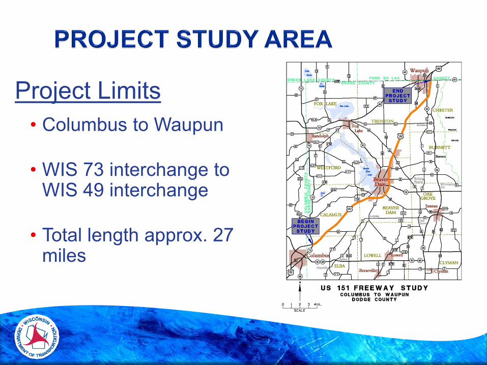
Project Limits• Columbus to Waupun
• WIS 73 interchange to WIS 49 interchange
• Total length approx. 27 miles

• Analyze US 151 corridor for conversion to freeway facility (Majority of US 151 within study limits is currently an expressway)• Expressway
• Four-lane divided roadway• Limited access to mainline for side roads and
private entrances
• Freeway• Four-lane divided roadway• Access to mainline only allowed at interchanges

• Columbus Bypass - 1991• Columbus to Beaver Dam
Expressway - 1993 • Beaver Dam Bypass - 1996• Beaver Dam to Waupun
Expressway - 1997• Beaver Dam Bypass – 2008• County D Interchange - 2011• STH 33 – 2014• Guardrail replacement
project - 2014

• Long-term plan and importance of highway• Connections 2030 Backbone Route
• Corridor Preservation
• Address increasing growth and development
• Facilitate planning for future land use and transportation needs
• Maintain long-term safety and operations

CORRIDOR
STUDY
Public Involvement
Preliminary Concepts
EA &
DESIGN
Environmental
Assessment
Range of Alternatives
Evaluation of Effects
FREEWAY
DECLARATION
&
OFFICIAL
MAP
We Are Here

• State Statute (Wis. Stat. 84.295(10)) authorizes WisDOT to create and update an official map for future freeways and expressways
• An official map allows WisDOT to preserve, protect, and set aside future right-of-way for US 151 where freeway design is being planned
• An official map also informs and enables landowners, the public, and local agencies to plan their future in ways that won’t conflict with the future highway improvements

• WisDOT will map and preserve land required to convert US 151 to a freeway under Wis. Statutes 84.295(10) including:
• Interchanges
• Grade separations (overpass/underpass)
• Alterations to existing public and private access points
• Alterations, removals, or additions to the local road system

• WIS 73 - Full diamond interchange
• County D – Reconstructed to full diamond interchange in 2012
• County G - Full diamond• WIS 33 - Full diamond• Industrial Drive - Half diamond• County B - Full diamond
STH 73 Interchange
Existing interchanges likely to remain

• County A - Full diamond• County M
• 2 movements allowed now
• WIS 26 - Full diamond• WIS 49 - Full diamond
County A Interchange
Existing interchanges likely to remain

Side roads• Access to US 151 relocated to
interchanges
• Modifications to local road network required
• Desirable distance between ramp terminals and frontage road is ¼ mile, min. 1,000’
• Overpass or underpass crossings of US 151
Redwood Road

Private access• All direct access removed
from US 151 include:• Commercial entrances• Driveways• Agricultural entrances
• Access to US 151 only at interchanges
• Frontage roads to provide connections to interchanges and local roads
Business along US 151

Eliminate at-grade railroad crossings • Crossing of Wis. Southern east of Beaver
Dam• Raise US 151 over railroad• US 151 spans both railroad and County E
• Crossing of Wis. Southern south of Waupun• Raise US 151 over railroad
• Overpass of Union Pacific crossing south of Beaver Dam to remain
At-grade RR crossing

• Environmental Data Collection
• Agency Input
• Developed Preliminary Concepts
• Completed a Value Planning Study
• Held 3 Public Involvement Meetings and 4 Local Officials Meetings
• Refined Preliminary Concepts and Developed a Recommended Alternative

• Division of farm properties resulting from loss of at-grade crossings of US 151
• Possible need to create alternative crossings of US 151 to serve farmers
• Longer and less direct commutes for some residents on/near the US 151 corridor
• Need for new local roads or extended driveways to replace direct access to US 151
• Impact on existing and proposed crossings for recreational users (snowmobiles, bicycles, etc.)

• Business access on Klatt Road
• Possible disincentive for non-agricultural development near the US 151 corridor where access is eliminated
• Possible increased pressure to develop near potential new interchanges
• Possible removal/relocation of buildings
• Likely increases in traffic on remaining routes with access to US 151
• Safety concerns at County C intersection

STUDY SECTIONS
• South Section• Columbus to Beaver Dam
• Central Section• Beaver Dam
• North Section• Beaver Dam to Waupun

Where did we begin?
19 Alternatives Initially Developed
• 10 South Section Alternatives: Columbus to Beaver Dam (Alternatives numbered 1 through 3; A,B,C,D)
• 9 North Section Alternatives: Beaver Dam to Waupun (Alternatives numbered 4 through 7; A,B,C)
• Central Section Alternative: Beaver Dam

Factor Matrix Evaluation

5 Alternatives Identified for Further Analysis
• 2 South Section Alternatives: Columbus to Beaver Dam (1C, 3C)
• 3 North Segment Alternatives: Beaver Dam to Waupun (5B, 5B Modified, 7A)• 5B Modified – new alternative since the last round of public
meetings; includes a partial cloverleaf interchange with County C vs. diamond
• Central Section Alternative: Beaver Dam

• South Section: Columbus to Beaver Dam (3C)
• North Section: Beaver Dam to Waupun (5B)
• Central Section

RECOMMENDED ALTERNATIVE
SOUTH SECTIONInterchange at County S
Overpasses at Salem Road, Forest Road and County DE
Reasons selected as the Recommended Alternative:
• Best Factor Matrix score• Less total land converted to
right-of-way• Fewer building relocations• Less relocated property
access• Fewer wetland impacts

RECOMMENDED ALTERNATIVE
SOUTH SECTION
Interchange at County S

RECOMMENDED ALTERNATIVE
SOUTH SECTION
Overpass County DE

RECOMMENDED ALTERNATIVE
CENTRAL SECTIONConsistent approach for all alternatives
Overpass of County E and Wisconsin & Southern RR
Frontage road connection from Kellom Road to Hemlock Road

RECOMMENDED ALTERNATIVENORTH SECTIONInterchanges at County C and County M (half diamond)
Overpasses at Breezy Point Road and Oakwood Road
Reasons selected as the Recommended Alternative:
• Best Factor Matrix Score• New interchange with County C vs.
Redwood Road• Conventional diamond interchange
design at County C• Less total land converted to ROW• Fewer wetland impacts

RECOMMENDED ALTERNATIVENORTH SECTION
Interchange at County C

RECOMMENDED ALTERNATIVENORTH SECTION
Interchange County M (half diamond)

• Wis. Stats. 84.295 and official mapping does not include construction
• No construction or project dollars are programmed at this time
• Possibly programmed, funded, and constructed over several decades or phases
• Funding is examined statewide• Short-term options may also be considered such
as intersection improvements and driveways and/or median alterations

• Comment Forms• Available at the check-in
desk• We encourage you to
provide us your feedback• Forms can be filled out
and submitted today or mailed by the specified date

Environmental Document 2016 - 2017Prepare Official Map 2019 - 2021
Mark WesterveldProject ManagerWisconsin Department of TransportationSouthwest Region – Madison2101 Wright StreetMadison, WI 53704-2583(608) [email protected]
Matthew BarrProject ManagerAyres Associates5201 E. Terrace Drive, Suite 200Madison, WI 53718(608) [email protected]
http://wisconsindot.gov/Pages/projects/by-region/sw/151/default.aspx
Project contacts
Project website
