psp 1078 & 1080 plumpton psp & kororoit psp · plumpton psp & kororoit psp psp 1078...
TRANSCRIPT
Plumpton PSP & Kororoit PSPPSP 1078 & 1080
November 2016
Amendment to the Melton Planning Scheme
Part A Submission - C146 & C147
Melton C146 & C147 | VPA submission to Planning Panels Victoria | November 2016
PART A | Summary of Submission Page 1 of 88
CONTENTS 1. INTRODUCTION ............................................................................................................ 3 2. PRELIMINARY MATTERS – PANEL DIRECTIONS............................................................... 4 3. WHOLE OF GOVERNMENT POSITION ............................................................................. 4 4. LOCAL CONTEXT ........................................................................................................... 4 4.1. Surrounding land use and development ................................................................................. 6 4.2. Existing planning scheme controls .......................................................................................... 7 5. FRAMEWORK FOR GROWTH AREA DEVELOPMENT ........................................................ 7 5.1. Background ........................................................................................................................... 7 5.2. Growth Corridor Plans: Managing Melbourne’s Growth ......................................................... 8 5.3. Melbourne Strategic Assessment and Biodiversity Conservation Strategy ............................... 9
5.3.1. Melbourne Strategic Assessment (MSA) .................................................................................................. 9
5.3.2. Biodiversity Conservation Strategy ........................................................................................................ 10
5.3.3. Time Stamping Native Vegetation .......................................................................................................... 10
5.3.4. Habitat Compensation ........................................................................................................................... 11
5.3.5. Commonwealth Approval for Urban Development under the Melbourne Strategic Assessment ........ 11 5.4. Plan Melbourne ................................................................................................................... 12 5.5. Ministerial Directions .......................................................................................................... 12
5.5.1. Ministerial Direction 11, Strategic Assessment of Amendments ........................................................... 12
5.5.2. Ministerial Direction 12, Urban Growth Areas ....................................................................................... 12 5.6. Precinct Structure Planning Guidelines and the Urban Growth Zone ..................................... 12 5.7. State Planning Policy Framework ......................................................................................... 14 6. BACKGROUND DOCUMENTS ....................................................................................... 15 6.1 Plumpton and Kororoit PSP Background Report .................................................................... 15 7. THE PRECINCT STRUCTURE PLANS ............................................................................... 16 7.1. Role and function of the PSPs .............................................................................................. 16 7.2. Vision of the Plumpton PSP ................................................................................................. 17 7.3. Vision of the Kororoit PSP .................................................................................................... 19 8. INFRASTRUCTURE CONTRIBUTIONS PLAN ................................................................... 20 9. THE AMENDMENTS ..................................................................................................... 21 9.1. Changes to the Amendment documentation in response to submissions .............................. 23
9.1.1 Applied Residential Zoning ...................................................................................................................... 24
9.1.2 Dry Stone Walls ....................................................................................................................................... 24
9.1.3 Delivery of improvements to Beattys Road reserve................................................................................ 24
9.1.4 Access to Sinclairs Road (Kororoit PSP) and Plumpton Road (Plumpton PSP) (proposed change in response to Council submissions) .................................................................................................................... 25
10. CONSULTATION & EXHIBITION .................................................................................. 26 APPENDIX 1 PLUMPTON PSP UNRESOLVED SUBMISSIONS – ISSUES REGISTER ................. 28 APPENDIX 2 UNRESOLVED SUBMISSIONS – KOROROIT PSP EXHIBITION ISSUES REGISTER 49 APPENDIX 3 PLUMPTON PSP CHANGES MATRIX WITH REFERENCE TO RELEVANT SUBMISSIONS ................................................................................................................. 66
Melton C146 & C147 | VPA submission to Planning Panels Victoria | November 2016
PART A | Summary of Submission Page 2 of 88
APPENDIX 4 KOROROIT PSP CHANGES MATRIX WITH REFERENCE TO RELEVANT SUBMISSIONS ................................................................................................................. 67 APPENDIX 5 PLUMPTON PSP PLANNING SCHEME ORDINANCES TRACK CHANGES ........... 68 APPENDIX 6 KOROROIT PSP PLANNING SCHEME ORDINANCES TRACK CHANGES ............. 69 APPENDIX 7 COMMONWEALTH NOTICE OF DECISION TO ENDORSE THE PROGRAM TO REVISE MELBOURNE UGB – FEBRUARY 2010 ................................................................... 70 APPENDIX 8 COMMONWEALTH APPROVAL FOR TAKING ACTIONS IN ACCORDANCE WITH THE ENDORSED EPBC ACT 1999 – JULY 2010 .................................................................... 72 APPENDIX 9 INDEX OF BACKGROUND REPORTS .............................................................. 73 APPENDIX 10 PROPOSED REVISIONS TO APPLIED RESIDENTIAL ZONES (PLUMPTON PSP AND KOROROIT PSP) .............................................................................................................. 74
1. Applied Residential Zoning ............................................................................................................. 74
2. Proposed updates – Plumpton PSP................................................................................................. 79
3. Proposed Updates – Kororoit PSP................................................................................................... 81 APPENDIX 11 PROPOSED REVISIONS TO DRY STONE WALL APPROACH (PLUMPTON PSP AND KOROROIT PSP) .............................................................................................................. 85 APPENDIX 12 PROPOSED NEW GUIDELINES FOR MINIMISING CROSSOVER IN THE SHORT TERM TO PLUMPTON RD (PLUMPTON PSP) AND SINCLAIRS RD (KOROROIT PSP) ............. 88
Melton C146 & C147 | VPA submission to Planning Panels Victoria | November 2016
PART A | Summary of Submission Page 3 of 88
1. Introduction This submission is made on behalf of the Victorian Planning Authority (VPA).
The VPA is the Planning Authority for amendments C146 and C147 to the Melton Planning Scheme (the Amendment).
The Amendment has been prepared by the VPA in collaboration with the Melton City Council, with the support of the relevant stakeholders, landowners and government agencies.
Formal exhibition of the Amendment commenced on 16 June 2016, and concluded on 18 July 2016. A total of 31 submissions have been received to Amendment C146 (Plumpton PSP) and a total of 34 received in response to Amendment C147 (Kororoit PSP).
All submissions requested changes to the Amendment and hence were referred to Panel on 07 September 2016.
The VPA has worked extensively with Council, developers, landowners and other stakeholders including State agencies to resolve as many of the submissions as possible. A register of the remaining issues that remain unresolved at this stage for each PSP is provided in Appendix 1 and Appendix 2. In addition, a register of issues that have led to agreed changes are provided in Appendix 3 – Appendix 6.
Note that during preparation of the Amendment the ‘VPA’ was formally known as the Metropolitan Planning Authority (MPA). However the organisation will be referred to as the ‘VPA’ throughout this Part A submission and the upcoming Panel hearing submission.
Melton C146 & C147 | VPA submission to Planning Panels Victoria | November 2016
PART A | Summary of Submission Page 4 of 88
2. Preliminary matters – Panel directions In its Directions issued on 03 November 2016 the Panel requested that the following matters be addressed in the VPA’s Part A Submission:
a) Background to the amendments. This is provided in Section 4 and 5 of this submission. Note that further detail is provided in the Plumpton and Kororoit PSP Background Report, which forms part of the exhibition documentation.
b) Strategic assessment. This is provided in Section 5 of this submission.
c) Identification of the issues raised in submissions and its response. This is provided in Appendix 3 (Plumpton) and Appendix 4 (Kororoit) of this submission.
d) A record of all changes to the Amendment documentation proposed as a result of the issues raised in submissions, and an indication of whether any such changes could impact on other landowners.
Since the exhibition of the proposed amendment, the VPA has met with submitters to discuss the range of issues. Where possible, officers from the Melton City Council and relevant State Agencies have been present and contributed to the discussions that have led to the resolution of issues. These discussions have resulted in proposed changes to the PSP and associated documents. This is addressed further in Section 9.1 of this submission.
A comprehensive list of all changes agreed to thus far is provided in Appendix 3 and Appendix 5 (Plumpton) and Appendix 4 and Appendix 6 (Kororoit).
Any updates to this table as a result of further resolutions of submissions following the circulation of this Part A Submission will be tabled on day 1 of the Panel Hearing.
e) An update on VPA’s understanding of all matters still unresolved between the parties. This is provided in Appendix 1 and Appendix 2 of this submission.
f) An index of the background reports prepared in relation to the PSP. This is provided in Appendix 9 of this submission.
3. Whole of Government Position The position presented by the VPA in this submission where relevant represents a whole of government position.
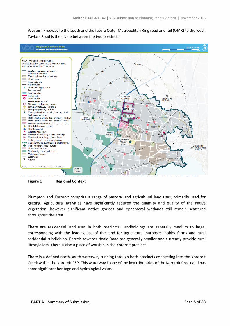
4. Local Context The Plumpton and Kororoit precincts are located within the Melton growth corridor in the municipality of Melton City Council. Plumpton (PSP 1078) and Kororoit (PSP 1080) are two separate precincts and have been prepared and progressed simultaneously. The precincts are geographically sited north and south of each other located approximately 30 kilometres west of Melbourne’s CBD. The Plumpton Precinct covers an area of approximately 1,016 hectares and Kororoit Precinct covers an area of approximately 925 hectare both shown in Figure 1. The precincts are bounded by the Melton Highway to the north, the developed suburbs of Hillside, Taylors Hill West and Caroline Springs to the east, the
Melton C146 & C147 | VPA submission to Planning Panels Victoria | November 2016
PART A | Summary of Submission Page 5 of 88
Western Freeway to the south and the future Outer Metropolitan Ring road and rail (OMR) to the west. Taylors Road is the divide between the two precincts.
Figure 1 Regional Context
Plumpton and Kororoit comprise a range of pastoral and agricultural land uses, primarily used for grazing. Agricultural activities have significantly reduced the quantity and quality of the native vegetation, however significant native grasses and ephemeral wetlands still remain scattered throughout the area. There are residential land uses in both precincts. Landholdings are generally medium to large, corresponding with the leading use of the land for agricultural purposes, hobby farms and rural residential subdivision. Parcels towards Neale Road are generally smaller and currently provide rural lifestyle lots. There is also a place of worship in the Kororoit precinct. There is a defined north-south waterway running through both precincts connecting into the Kororoit Creek within the Kororoit PSP. This waterway is one of the key tributaries of the Kororoit Creek and has some significant heritage and hydrological value.
Melton C146 & C147 | VPA submission to Planning Panels Victoria | November 2016
PART A | Summary of Submission Page 6 of 88
4.1. Surrounding land use and development
A number of new settlements are currently planned, being developed or development has recently finalised around Plumpton and Kororoit. The surrounding land uses (existing and future planned areas) include:
• Kororoit PSP Part 2: The proposed Kororoit Regional Park is directly south-east of the Kororoit PSP. It was originally included as part of the overall Kororoit PSP however it has been separated from PSP 1080 until the boundary for the proposed Regional Park has been confirmed by the Department of Environment, Land, Water and Planning (DELWP) and approved by the Commonwealth Government. A separate amendment will be undertaken to finalise PSP 1080.2 once the boundary has been confirmed.
• Rockbank PSP: Immediately south-west of Kororoit PSP. The precinct includes a total area of 750 hectares and its future land use will be predominantly residential in nature. Rockbank is projected to have a future population of 22,200 people and yield of around 7,900 dwellings.
• Rockbank North PSP: Rockbank North (Woodlea Estate) is located west of Kororoit PSP, across the OMR. Rockbank North PSP was approved in June 2012 and development is currently underway. Upon completion it is expected to include 7,100 residential lots and have a population of 20,400 people. It will include a major and local town centres, three primary schools, a secondary school, a health and education precinct and an indoor sports facility.
• Warrensbrook PSP: Is directly west of the Plumpton PSP. It is a future residential precinct and a hub of tourism and agribusiness development. The area includes a number of wineries and function facilities. The PSP planning is yet to commence.
• Mt Atkinson and Tarneit Plains PSP: Located directly south of the Kororoit PSP area but separated by the Western Freeway. The PSP area will comprise a specialised town centre, significant employment areas (mixed use, industrial and business) and residential land. It is anticipated to have over 6,700 new homes for approximately 19,700 residents and opportunities for 18,000 jobs.
• Warrawee PSP: Is a future employment precinct including an area of significant grassland values. The PSP planning is yet to commence.
• Ravenhall PSP: The Ravenhall PSP has not yet commenced. Current activities within the PSP area include the Boral quarry and the Melbourne Regional Landfill. A proposed expansion of the Melbourne Regional Landfill is the subject of a current planning permit application, which will be considered by the Minister for Planning. The proposed expansion will not significantly affect planning in the Plumpton or Kororoit PSPs, as any buffers which might be imposed by the future expansion are understood not to reach the Kororoit PSP.
• Taylors Hill West PSP: Taylors Hill West is located east of the Plumpton PSP, was approved in May 2010 and will accommodate a future population of over 6,700 people. A number of housing estates are in the early stages of construction of the subdivision or nearing completion. They include Aria, Aspire, Encore, Infinity, Orbis Green, Springlands, The Point, Sienna and Auburn. The compact residential community of Taylors Hill West integrates with and complements Taylors Hill and Caroline Springs.
• Caroline Springs and Taylors Hill: Development for Caroline Springs commenced in the late 1990s on greenfield land with the construction of the Delfin Caroline Springs estate. Growth

Melton C146 & C147 | VPA submission to Planning Panels Victoria | November 2016
PART A | Summary of Submission Page 7 of 88
occurred rapidly from 1999 and between 2001 and 2006 the population quadrupled. Development is nearing completion and has reached a population of 24,025. Taylors Hill followed a similar pattern to Caroline Springs with development dating primarily from the late 1990s. Rapid growth took place between 2001 and 2011 and growth is expected to continue but at a slower rate. Taylors Hill has a current population of 11,769 people.
• Western Plains North Green Wedge: To the north of the Melton Highway the land is part of the Western Plains North Green Wedge. The land use is generally low intensity agricultural/rural and the landscape is flat and extensively cleared. The land is also affected in part by the Melbourne Airport Environs Overlay.
4.2. Existing planning scheme controls The existing zones and overlays within the precincts are outlined below.
Plumpton • Urban Growth Zone • Farming Zone (for land within the electricity easement traversing north-south) • Urban Floodway Zone • Public Acquisition Overlay Schedule 3 (VicRoads – future OMR)
Kororoit • Urban Growth Zone • Farming Zone (for land within the electricity easement traversing north-south) • Rural Conservation Zone (over Kororoit Creek corridor) • Urban Floodway Zone • Public Park and Recreation Zone • Public Acquisition Overlay Schedule 3 (VicRoads – future OMR) • Environmental Significance Overlay schedules 1 & 3 • Development Plan Overlay Schedule 1 • Heritage Overlay Schedule 4 (Deanside Homestead) & Schedule 118 (Rockbank Headstation
Dam)
5. Framework for Growth Area Development Growth area planning is guided by a hierarchy of plans prepared by state and local governments at a municipal or precinct level. The hierarchy of plans provide the framework for growth area planning and development and seek to achieve the objectives of the State Planning Policy Framework.
5.1. Background
The Urban Growth Boundary (UGB) designates the long-term limits of urban development and where non-urban values and land uses should prevail in metropolitan Melbourne.
The UGB first came into effect in 2002 in conjunction with the release of Melbourne 2030. This plan established the long term plan for land within the UGB, including the intention to review the boundary at an appropriate time in the future.
Melton C146 & C147 | VPA submission to Planning Panels Victoria | November 2016
PART A | Summary of Submission Page 8 of 88
Melbourne at 5 Million in 2008 and the subsequent Delivering Melbourne’s Newest Sustainable Communities Program Report 2009 facilitated the expansion of the UGB in 2010. It was at this time that the land which forms the Plumpton and the Kororoit precincts was brought into the UGB.
Work on Melbourne’s Growth Corridor Plans began in 2011, with consultation at the end of the same year. These plans were formally approved by the Minister of Planning in mid-2012. These are discussed in more detail below.
5.2. Growth Corridor Plans: Managing Melbourne’s Growth
The Growth Corridor Plans: Managing Melbourne’s Growth (GCP) are high level integrated land use and transport plans that provide a strategy for the development of Melbourne’s growth corridors over the next thirty to forty years.
These plans will guide the delivery of key housing, employment and transport infrastructure and open space in Melbourne’s newest metropolitan suburbs.
The GCP identifies:
• The long term pattern of land use and development; • Committed transport networks as well as network options for investigation; • Committed regional open space networks as well as investigation sites; and • Opportunities for creating green corridors.
The GCP informs the development and review of local planning schemes and the preparation of future strategies, structure plans and other planning tools. They also provide a strategic basis for infrastructure and service planning as well as sequencing of land release.
The preparation of PSPs is the primary vehicle for the implementation of the GCP.
The West Growth Corridor Plan covers Melbourne’s western corridor and includes large areas of the Melton City Council and Wyndham City Council. The Plumpton and Kororoit precincts are within the West GCP.
The West GCP outlines key existing and future infrastructure items in direct proximity to the precinct that will provide direct or flow-on benefits to future residents in the area, including:
• Arterial roads for private and public transport (buses) • Future rail stations • Future Principal Public Transport Network • E6 transport corridor / Outer Metropolitan Ring road and rail • Future industrial, business, and residential areas • Community, health and education facilities • New major and specialised town centres including at Mt Atkinson, Plumpton and Rockbank
North • Future Western Industrial Precinct • Open space (including the proposed future Kororoit Regional Park) and Nature Conservation
Areas • Growling Grass Frog Conservation Areas along the Kororoit Creek • Metropolitan Trail Network.
Melton C146 & C147 | VPA submission to Planning Panels Victoria | November 2016
PART A | Summary of Submission Page 9 of 88
The West GCP identifies the Plumpton precinct as industrial and residential with a major town centre; and the Kororoit precinct as residential with areas of biodiversity values. The respective PSP’s refine the uses as shown in the Corridor Plan, as follows:
• The West GCP proposed the MTC on the south east side of the intersection of Hopkins Road and Tarleton Road. However following further design work undertaken as part of the PSP including consideration of improved integration with the future business and industrial precinct to the west, residential catchment, and a feasible size and shape of the MTC given the waterway constraints, the PSP has relocated the MTC to the north east intersection. This also recognizes Beattys Road alignment as a significant heritage feature within the Melton area due to its former role as a route to the goldfields, which will form the civic spine of the MTC. It will become a focal point and a location for high order community infrastructure.
• The designation of ‘industrial’ land in the north-west portion of the Plumpton precinct has been refined to propose Mixed Use and Commercial 2 zoning along the western side of Hopkins Road opposite the proposed MTC to improve the transition from industrial land to the Plumpton Major Town Centre, and encourage opportunities for a diversification of employment.
• The areas identified as having biodiversity values have been retain in the Kororoit precinct consistent with the West GCP. However the area identified for the proposed Kororoit Regional Park has been separated from PSP 1080 until the boundary for the proposed Regional Park has been confirmed by DELWP and approved by the Commonwealth Government. A separate amendment will be undertaken to finalise PSP 1080.2 once the boundary has been confirmed.
5.3. Melbourne Strategic Assessment and Biodiversity Conservation Strategy
5.3.1. Melbourne Strategic Assessment (MSA)
In June 2009, the Victorian and Commonwealth governments agreed to undertake a strategic assessment of the Victorian Government's urban development program Delivering Melbourne’s Newest Sustainable Communities Program Report 2009.
The program involves urban development in four growth corridors and in 28 existing urban precincts, as well as the development of a Regional Rail Link Corridor between Werribee and Deer Park and the Outer Metropolitan Ring/E6 Transport Corridor.
The areas included in the program and covered by the Melbourne Strategic Assessment (MSA) are:
• Areas added to the Urban Growth Boundary by planning scheme amendment VC68 (the 2010 Urban Growth Boundary) – this includes the Plumpton and Kororoit precincts.
• Areas in the Outer Metropolitan Ring/E6 Transport Corridor and the Regional Rail Link corridor • Areas in the existing 28 urban precincts within the 2005 Urban Growth Boundary.
The Melbourne Strategic Assessment (MSA) evaluates the impacts of the Victorian Government’s urban development program for Melbourne on matters of national environmental significance (MNES) protected under the Commonwealth Environment Protection and Biodiversity Conservation Act 1999 (EPBC Act). It also establishes conservation measures to mitigate these impacts. The MSA requires the Victorian Government to make commitments to the Commonwealth Government in relation to
Melton C146 & C147 | VPA submission to Planning Panels Victoria | November 2016
PART A | Summary of Submission Page 10 of 88
conservation outcomes and measures to protect these MNES, which are outlined in Delivering Melbourne’s Newest Sustainable Communities Program Report 1 (the Program Report).
The MSA delivers a single environmental approval for both Victorian and Commonwealth environmental regulation for the first time. The program represents a significant cost saving in the order of $500 million over the expected 30- year period of development, primarily arising from the reduction in holding costs, avoiding opportunity cost associated with land take in the growth corridors and a reduction in information costs and administrative burden.
The MSA commitments included the preparation of the Biodiversity Conservation Strategy for Melbourne’s Growth Corridors (BCS) (DEPI, June 2013) which describes the overarching strategy for the protection of biodiversity within Melbourne’s growth corridors. The BCS sets out the detailed conservation measures required for Victoria to satisfy the commitments made to the Commonwealth Government under the MSA and meet State requirements for biodiversity under the Victoria planning scheme. These conservation measures will be funded using a cost recovery model. The program will generate incomes of close to $1 billion over the next 40 years towards the delivery of the program.
A copy of the Commonwealth notice to endorse the program to revise the Melbourne Urban Growth Boundary as signed in February 2010 can be found at Appendix 7.
5.3.2. Biodiversity Conservation Strategy
The approved BCS is the overarching strategy for the protection of biodiversity in the growth corridors and finalises the planning for biodiversity under the Melbourne Strategic Assessment.
The BCS sets out the conservation measures required to satisfy the commitments to the Commonwealth Government and to meet state biodiversity requirements.
The purpose of the BCS is to:
• Inform and guide the preparation of the Growth Corridor Plans • Outline how the conservation outcomes for MNES in the Program Report will be achieved
spatially within the growth corridors and how impact on the matters of national significance will be mitigated
• Identify land within the growth corridors that is required to be protected due to the sub-regional species strategies and the prescriptions for matters of national environmental significance
• Identify how areas set aside for conservation purposes will be managed; and • Identify how mitigation measures will be implemented.
Essentially, the BCS identifies those MNES that must be protected and conserved and those areas that can be removed to enable the urban expansion of Melbourne.
5.3.3. Time Stamping Native Vegetation
The time-stamping project captured and “time-stamped” native vegetation information to establish a native vegetation dataset and maps showing the type, extent and condition of all native vegetation in the growth corridors. This information has been used, along with information on threatened species habitat from the conservation strategies, to calculate habitat compensation obligations and native vegetation offsets for urban development.
Melton C146 & C147 | VPA submission to Planning Panels Victoria | November 2016
PART A | Summary of Submission Page 11 of 88
The time-stamping data applies to the four growth corridors in the expanded 2010 Urban Growth Boundary and 16 of the existing 28 urban precincts in the 2005 Urban Growth Boundary covered by the BCS.
The Victorian Government undertook extensive consultation as part of the time-stamping project; providing opportunities for landowners to review the Department of Environment Land Water and Planning’s (DELWP) understanding of the native vegetation on their property and submit changes for consideration.
The report Time-stamping native vegetation data – Public Consultation 2010 – 12 Final Report (May 2013) outlines the growth corridor native vegetation survey, the public consultation process and explains how the data set was finalised.
5.3.4. Habitat Compensation
The habitat compensation scheme enables collection of offsets for the removal of native vegetation and loss of habitat for threatened species protected under the EPBC Act on land developed for urban uses within Melbourne’s growth corridors.
The introduction of a flat fee for native vegetation removal and loss of habitat for threatened species affected by urban development in Melbourne’s growth corridors provides a streamlined and consistent offset framework for landowners to make informed decisions about the costs of development. It also means that landowners can meet their offset obligations with an in-lieu payment and will not be required to undertake assessments or enter into negotiations. The availability of staged fee payments acknowledges the scale and sequencing of development in the growth corridors and responds to the request from industry for this flexible payment option to be made available.
The document named Habitat Compensation under the Biodiversity Conservation Strategy August 2011 provides further details of the cost recovery model, the required fees and the obligations and means by which the habitat compensation system operates.
5.3.5. Commonwealth Approval for Urban Development under the Melbourne Strategic Assessment
The BCS identifies three conservation areas with the Kororoit precinct: Conservation Area 1; Conservation Area 2; and Conservation Area 15 (part).
On 5 September 2013 the Commonwealth Minister for the Environment approved all actions associated with urban development in the west growth corridor as described in the BCS. Importantly this approval was issued subject to conditions.
Condition 3 of this approval is relevant to Conservation 15 as it states that, “Persons must not take any actions that would cause, or otherwise facilitate, a net loss of area of the conservation areas numbered ….15…, unless agreed by the Minister.” (ie the Commonwealth Minister for the Environment)
Condition 4 of the approval is pertinent to Conservation Areas 1 and 2, and states that, “Persons must not take any actions that would cause, or otherwise facilitate, a change in the boundaries of the conservation areas numbered 1 to 9, ….. unless agreed by the Minister.” (i.e. the Commonwealth Minister for the Environment). The Approval Decision can be found at Appendix 8.
Melton C146 & C147 | VPA submission to Planning Panels Victoria | November 2016
PART A | Summary of Submission Page 12 of 88
The most contentious issue raised specifically with regard to BCS matters in the Kororoit PSP relates to the Conservation Area 15 (Growling Grass Frog corridor). This will be expanded upon in the VPA’s Part B submission to Panel.
5.4. Plan Melbourne
Plan Melbourne: Metropolitan Planning Strategy, an adopted government policy document released by the Victorian Government in May 2014, outlines the provision of necessary infrastructure and support for development proposed by the West Growth Corridor Plan as part of its discussion regarding Melbourne’s Western Sub-region. The Plan Melbourne Refresh Discussion Paper, released in October 2015, also addresses key issues of housing supply, diversity and affordability, employment, climate change and more current government transport network priorities.
5.5. Ministerial Directions
The amendment complies with the Ministerial Directions applicable to the amendment as detailed in the explanatory report. More broadly, the amendment complies with the following Ministerial Directions relating to the preparation of an amendment within the urban growth areas including:
5.5.1. Ministerial Direction 11, Strategic Assessment of Amendments
The Amendment has been strategically assessed in accordance with the assessment criteria set out in Ministerial Direction 11.
The amendment will implement the objectives of planning in Victoria by providing for the fair, orderly, economic and sustainable use of land identified for urban purposes.
The amendment has addressed environmental effects, as the pattern of land use and development was guided by studies of the area relating to flora and fauna, flooding and drainage.
The amendment has addressed social and economic effects. It is expected to have a positive social and economic effect through the provision of additional housing and community facilities, as well as the creation of local employment opportunities.
5.5.2. Ministerial Direction 12, Urban Growth Areas
This Direction applies to the preparation of any planning scheme amendment that provides for the incorporation of a PSP in the scheme or the introduction of, or changes to, provisions in a schedule to the Urban Growth Zone (UGZ). Therefore, the Direction applies to the Amendment.
The Direction provides that the Amendment must implement the Growth Area Corridor Plan relevant to the land and must be in accordance with applicable Precinct Structure Plan Guidelines.
5.6. Precinct Structure Planning Guidelines and the Urban Growth Zone
On 7 October 2009 the Minister for Planning launched the Precinct Structure Planning Guidelines. These Guidelines replace the draft 2006 version and provide a tool for designing and delivering better quality
Melton C146 & C147 | VPA submission to Planning Panels Victoria | November 2016
PART A | Summary of Submission Page 13 of 88
communities in growth areas. They set out the key objectives of growth area planning and include a step by step guide on how to achieve the identified objectives.
The overarching objectives for PSPs are set out in the guidelines.
They are to:
• Establish a sense of place and community; • Create greater housing choice, diversity and affordable places to live; • Create highly accessible and vibrant activity centres; • Provide local employment and business activity; • Provide better transport choices; • Respond to climate change and increase environmental sustainability; • Deliver accessible, integrated and adaptable community infrastructure.
The explanatory report details how the amendment meets each objective of the Precinct Structure Planning Guidelines.
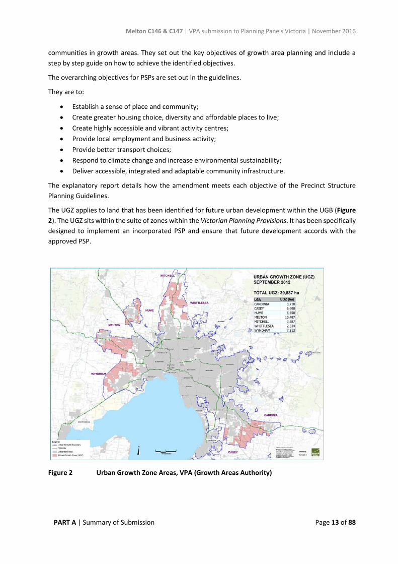
The UGZ applies to land that has been identified for future urban development within the UGB (Figure 2). The UGZ sits within the suite of zones within the Victorian Planning Provisions. It has been specifically designed to implement an incorporated PSP and ensure that future development accords with the approved PSP.
Figure 2 Urban Growth Zone Areas, VPA (Growth Areas Authority)

Melton C146 & C147 | VPA submission to Planning Panels Victoria | November 2016
PART A | Summary of Submission Page 14 of 88
The UGZ includes two parts:
1. Part A - Applies to land when no PSP applies; and 2. Part B – Applies to land when a PSP applies.
The land subject to this amendment is included within a PSP and as such Part B of the UGZ will be applicable once the amendment is completed. The UGZ includes zone provisions which seek to provide certainty about the nature of future development, streamline the approval process and ensure that permits for development accord with the incorporated PSP.
A schedule to the Urban Growth Zone is drafted for each PSP area and can include requirements for land use, buildings and works, application/advertising requirements, decision guidelines and any other conditions/requirements.
The UGZ Schedules for Amendment C146 and Amendment C147 to the Melton Planning Scheme have been designed to ascribe a suite of Victoria Planning Provision zones to guide future use and development of the site through the specification of conditions and requirements for permits. The design of the zone promotes consistency in the manner in which planning authorities deal with land use issues and ensures that the zone implements the State Planning Policy Framework.
The amendment will introduce the Urban Growth Zone Schedule 11 (Plumpton PSP) and Schedule 12 (Kororoit PSP) to the Melton Planning Scheme and apply it to the relevant amendment areas. This Planning Scheme ordinance has been structured in such a way that the ultimate translation to conventional Victorian Planning Provision zones can occur in a timely and efficient manner once the land has been developed.
The amendments were also proposed to introduce a Development Contributions Plan Overlay Schedule 10 (Plumpton) and Schedule 11 (Kororoit) to the Melton Planning Scheme and apply them to the relevant amendment areas. This mechanism was chosen to preface the new format infrastructure contributions levy system (ICP) framework that was formally approved upon the release of the Ministerial Direction in October 2016. The DCPO included a trigger to require permit applicants to enter into an agreement with the Council to deliver related infrastructure identified through the Precinct Infrastructure Plan (PIP).
This approach will now be reviewed in light of the now-released Ministerial Directions, and further outlined in the VPA’s Part B submission to the Panel.
5.7. State Planning Policy Framework
The State Planning Policy Framework (SPPF) ensures that the objectives of section 4 of the Planning and Environment Act 1987 are implemented through appropriate land use development by addressing environmental, social and economic factors to achieve sustainable development.
The relevant clauses and provisions of the SPPF are:
• Clause 11 – Settlement; • Clause 12 – Environment and Landscape Values; • Clause 16 – Housing; • Clause 17 – Commercial; • Clause 18 – Transport;
Melton C146 & C147 | VPA submission to Planning Panels Victoria | November 2016
PART A | Summary of Submission Page 15 of 88
• Clause 19 – Infrastructure.
The amendments achieve the objectives of the above clauses by:
• Providing a plan for land that has been identified as being suitable for housing, commercial, recreation, open space and infrastructure opportunities.
• Planning for accessibility via a range of transport nodes to key destinations in the surrounding neighbourhoods.
• Facilitating development of a range of housing densities that will cater to a range of household types and income levels.
• Responding to the environmental qualities of the area through the retention and protection of areas identified as having biodiversity values.
• Including Planning Scheme mechanisms and PSP requirements to protect and enhance areas identified as having heritage significance.
6. Background Documents The preparation of the PSPs and the subsequent planning scheme amendments are supported by a number of background reports. The reports that are listed at Appendix 9 of this submission were commissioned throughout the stages of the PSP.
These background studies informed the pre-planning of the PSPs. Copies of these reports have been previously provided to Planning Panels Victoria and are available to all parties and the public on the VPA website as they have become available, prior to and as part of the formal exhibition process.
6.1 Plumpton and Kororoit PSP Background Report
The VPA prepared the Plumpton & Kororoit PSP Background Report (June 2016), which provided a response to the key recommendations of the background studies and formed part of the Amendment documentation. This report summarises the background to the preparation of the PSPs and describes how the PSPs respond to the following issues and/or themes: Cultural heritage Post-contact heritage Land contamination Biodiversity Bushfire threat and management actions Town centres, industrial precinct and retail Community facilities Emergency services Open space Whole of water cycle assessment, water and drainage Transport and movement Utility and service infrastructure

Melton C146 & C147 | VPA submission to Planning Panels Victoria | November 2016
PART A | Summary of Submission Page 16 of 88
Rather than repeat the information in this Part A submission to the Panel, it is recommended that the Plumpton & Kororoit PSP Background Report (June 2016) be viewed for further detail and background to the PSPs if required.
7. The Precinct Structure Plans 7.1. Role and function of the PSPs
The precinct structure plans for the Plumpton and Kororoit precincts are long-term plans for future urban development of the land. It describes how the land is expected to be developed, including how and where community and development services are planned to support the growing communities. The PSPs provide a guide for the delivery of an urban environment that will form an extension of the existing Taylors Hill and Caroline Springs suburbs to the east of the subject precincts. The PSPs and associated amendments to the Melton Planning Scheme will facilitate the PSPs and enable the orderly transition of non-urban land to urban land. The PSPs include plans of the necessary transport and community infrastructure projects required to ensure that future residents, visitors and workers within the precincts are provided with timely access to services and transport essential to support the future communities. The amendments will incorporate each PSP into the Melton Planning Scheme ensuring Government agencies, Melton City Council, developers, the local communities, and investors have certainty about the future development of the precincts.
Melton C146 & C147 | VPA submission to Planning Panels Victoria | November 2016
PART A | Summary of Submission Page 17 of 88
7.2. Vision of the Plumpton PSP
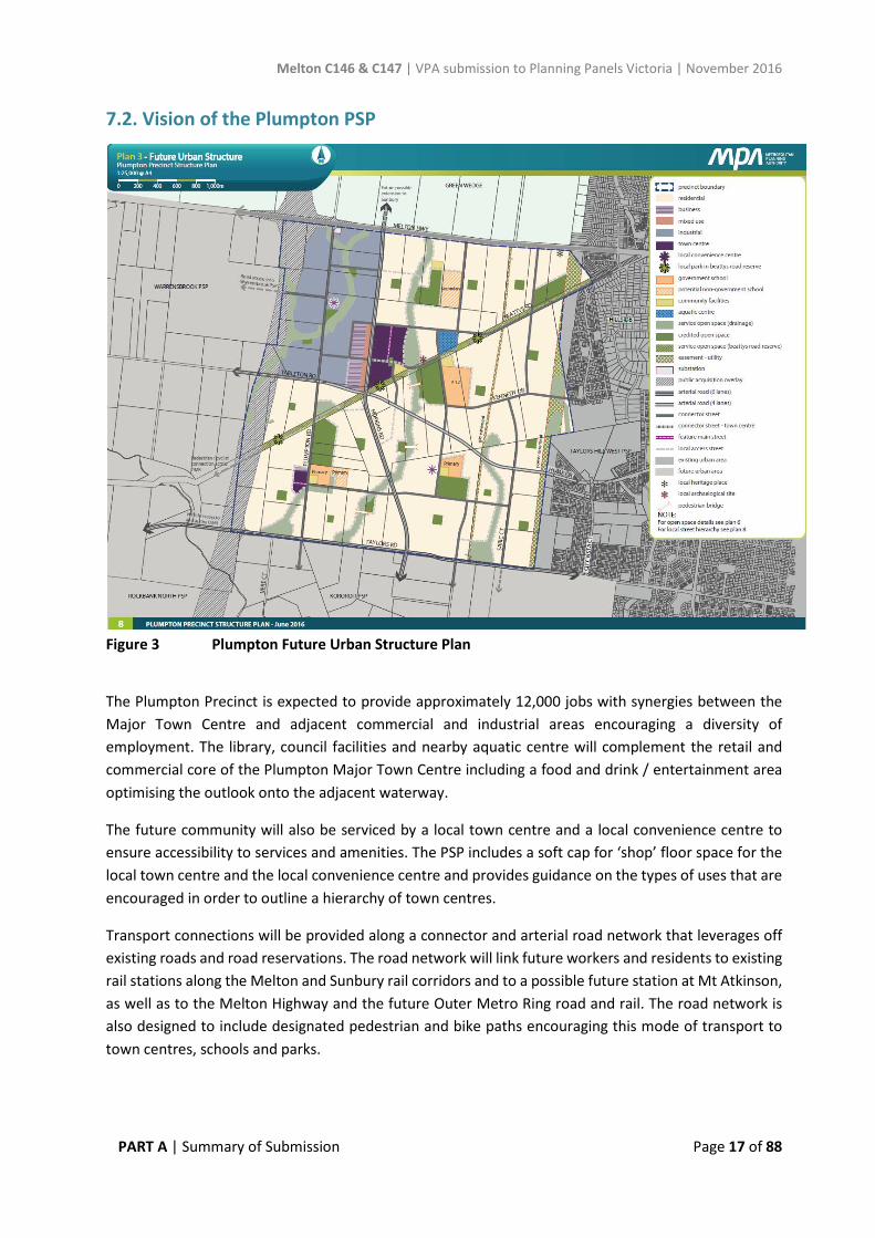
Figure 3 Plumpton Future Urban Structure Plan
The Plumpton Precinct is expected to provide approximately 12,000 jobs with synergies between the Major Town Centre and adjacent commercial and industrial areas encouraging a diversity of employment. The library, council facilities and nearby aquatic centre will complement the retail and commercial core of the Plumpton Major Town Centre including a food and drink / entertainment area optimising the outlook onto the adjacent waterway.
The future community will also be serviced by a local town centre and a local convenience centre to ensure accessibility to services and amenities. The PSP includes a soft cap for ‘shop’ floor space for the local town centre and the local convenience centre and provides guidance on the types of uses that are encouraged in order to outline a hierarchy of town centres.
Transport connections will be provided along a connector and arterial road network that leverages off existing roads and road reservations. The road network will link future workers and residents to existing rail stations along the Melton and Sunbury rail corridors and to a possible future station at Mt Atkinson, as well as to the Melton Highway and the future Outer Metro Ring road and rail. The road network is also designed to include designated pedestrian and bike paths encouraging this mode of transport to town centres, schools and parks.
Melton C146 & C147 | VPA submission to Planning Panels Victoria | November 2016
PART A | Summary of Submission Page 18 of 88
The erstwhile gold route along Beattys Road shapes the structure of the Precinct and will be reinterpreted as a street and linear park. Beattys Road Reserve will draw visitors to play areas and community facilities punctuating its length, and will provide strong links to areas east and west of the PSP.
North-south easements and waterways inform the locations of community infrastructure and town centres and will become popular recreation areas in their own right. They will connect through to the Kororoit Creek, the proposed Kororoit Regional Park, and the historic Deanside Homestead Complex in the Kororoit PSP area to the south. Linear paths along this open space network will also connect to local destinations including parks, play areas and sporting reserves which will encourage healthy lifestyles and engagement across the community.
Sporting reserves will be developed in a range of sizes to adapt to different sporting needs over time, and are located near to waterways so that stormwater harvesting may be realised in future.
The Aboriginal history of the area will be enhanced through protection of significant places and through signage and information relating to this history. The area’s post-contact history will be protected through retention of significant dry stone walls and other heritage sites, which will help develop a sense of place for the growing community.
Diversity of dwelling sizes and types will provide affordable and flexible housing and live-work opportunities. Both the major town centre and the local town centre will offer shopping, community facilities and services immediately adjacent to residential areas, providing convenient access over the full life-cycle to enable ageing-in-place. The adjacency of higher density residential areas to the town centres will ensure that these are vibrant places by day and by night.
Melton C146 & C147 | VPA submission to Planning Panels Victoria | November 2016
PART A | Summary of Submission Page 19 of 88
7.3. Vision of the Kororoit PSP
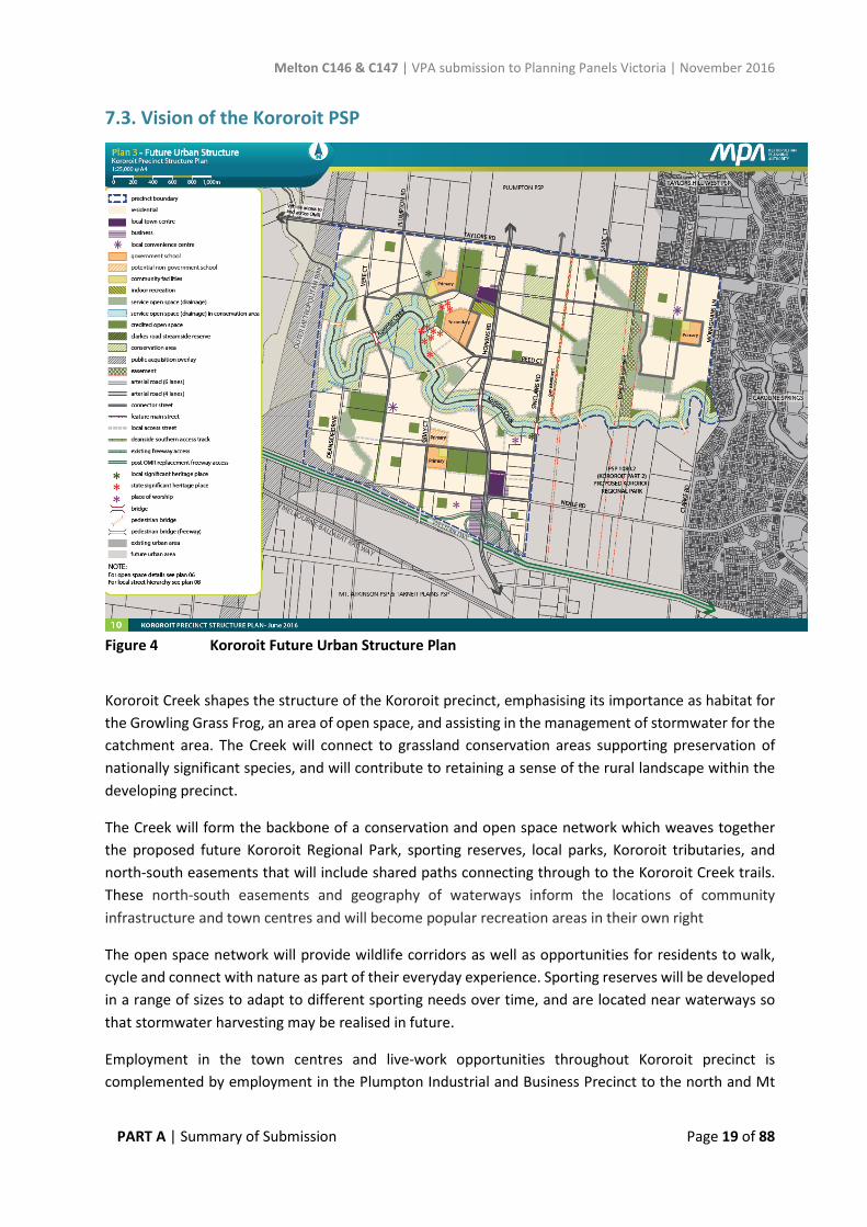
Figure 4 Kororoit Future Urban Structure Plan
Kororoit Creek shapes the structure of the Kororoit precinct, emphasising its importance as habitat for the Growling Grass Frog, an area of open space, and assisting in the management of stormwater for the catchment area. The Creek will connect to grassland conservation areas supporting preservation of nationally significant species, and will contribute to retaining a sense of the rural landscape within the developing precinct.
The Creek will form the backbone of a conservation and open space network which weaves together the proposed future Kororoit Regional Park, sporting reserves, local parks, Kororoit tributaries, and north-south easements that will include shared paths connecting through to the Kororoit Creek trails. These north-south easements and geography of waterways inform the locations of community infrastructure and town centres and will become popular recreation areas in their own right
The open space network will provide wildlife corridors as well as opportunities for residents to walk, cycle and connect with nature as part of their everyday experience. Sporting reserves will be developed in a range of sizes to adapt to different sporting needs over time, and are located near waterways so that stormwater harvesting may be realised in future.
Employment in the town centres and live-work opportunities throughout Kororoit precinct is complemented by employment in the Plumpton Industrial and Business Precinct to the north and Mt
Melton C146 & C147 | VPA submission to Planning Panels Victoria | November 2016
PART A | Summary of Submission Page 20 of 88
Atkinson and Tarneit Plains precinct to the south, accessible along the future Hopkins Road. Convenient access to further job opportunities will be via bus services, along the Western Freeway and future Outer Metro Ring road, and potentially via the rail network with a possible railway station at Mt Atkinson.
Walking and cycling to town centres, schools and parks will be attractive modes of transport choice along tree-lined streets with dedicated, off-road pedestrian and cycle paths. Historic dry stone walls will contribute to place-making and increase the appeal of walking and cycling along streets throughout the Precinct.
Diversity of dwelling sizes and types will provide affordable and flexible housing and live-work opportunities. The two Local Town Centres will offer shopping, community facilities, areas for small local enterprises and local services immediately adjacent to residential areas, which will give convenient access over the full life-cycle to enable ageing-in-place.
Significant Aboriginal heritage places along Kororoit Creek will be protected through respectful siting of new bridges which link communities to the south and north of the Creek. The Deanside Homestead Complex will become a treasured and more visible part of the local landscape through its proximity to a local park and the Kororoit Creek shared paths. Landscape links to related parts of its history, such as the dam wall to its north and the old walking track to the south, will cement its role in the post-contact development of the Kororoit PSP area.
8. Infrastructure Contributions Plan The future Plumpton and Kororoit ICP will set out the requirements for infrastructure funding across both precincts. The ICP will be a separate document incorporated into the Melton Planning Scheme and will be implemented through an Infrastructure Contributions Plan Overlay (ICPO). The ICP mechanism is the subject of recent legislation and ministerial direction that was released in October 2016.
Given the recent release of the Ministerial Direction the Plumpton and Kororoit ICP is still under preparation and will be implemented by a separate amendment to the Melton Planning Scheme in accordance with the Ministerial Direction.
The infrastructure projects that are expected to be included in the ICP are listed in Table 9 - Precinct Infrastructure of the PSP, and shown on Plan 12 – Precinct Infrastructure Plan (Transport) and Plan 13 – Precinct Infrastructure Plan (Community & Open Space) of each PSP.
The VPA will provide an understanding of what is proposed with respect to progressing the Infrastructure Contributions Plan in its Part B submission to the Panel.
Melton C146 & C147 | VPA submission to Planning Panels Victoria | November 2016
PART A | Summary of Submission Page 21 of 88
9. The Amendments Amendments C146 and C147 to the Melton Planning Scheme (the Scheme) propose to make a number of changes to facilitate the development and use of land within the Plumpton and Kororoit precinct areas. The amendments insert Schedules 11 and 12 to the Urban Growth Zone into the Scheme and subsequently rezone the majority of land within the PSP boundary areas, which will enable the implementation of the Plumpton PSP and Kororoit PSP.
The following lists are reflective of the exhibited documentation and what each amendment proposes to make to the Melton Planning Scheme:
Amendment C146 – Plumpton Precinct Structure Plan
• Insert and apply Schedule 11 to the Urban Growth Zone (UGZ11) to the majority of land in the Precinct. The zone requires land use and development to be generally in accordance with the incorporated Plumpton Precinct Structure Plan, June 2016;
• Insert Schedule 10 to the Special Use Zone (SUZ) and rezones existing Farming Zone (FZ) within the Precinct to Special Use Zone Schedule 10 (SUZ10) over land encumbered by a power easement;
• Amend the map of the Public Acquisition Overlay (PAO3) to delete approximately 1km length of east-west oriented reservation between Beattys Road and Tarletons Road;
• Insert Schedule 10 to the Development Contributions Plan Overlay (DCPO10) and apply the overlay to all land within the Amendment area;
• Amend the Schedule to Clause 52.01 to include a public open space contribution for subdivision of land within the Amendment area;
• Amend the Schedule to Clause 52.02 to exempt permit requirements for the removal of a restrictive covenants from the following properties in Plumpton 451-471 Beattys Road (Lot 8 on PS219656R); 1241-1249 Plumpton Road (Lot 7 on PS219656R); 1251 Plumpton Road (Lot 1 on PS648499M); 1257 Plumpton Road (Lot 2 on PS648499M); 1259-1265 Plumpton Road (Lot 5 on PS219656R); 1267-1275 Plumpton Road (Lot 4 on PS219656R); 1200-1306 Taylors Road (Lot 3 on PS219656R); 1176-1198 Taylors Road (Lot 2 on PS219656R); and, 1152-1174 Taylors Road (Lot 1 on PS219656R).
• Amend the Schedule to Clause 52.17 to exempt permit requirements for native vegetation removal within the Precinct.
• Amend the Schedule to Clause 66.04 to include the Growth Area Authority as a determining referral authority for permit applications to develop land where value for works is in excess of $500,000 on land identified as the Plumpton Major and Local Town Centre’s pursuant to Clause 2.10 of the UGZ11;
• Amend the Schedule to Clause 66.06 to include notice to the owner and operator of the gas transmission pipeline for an application to use land for sensitive purposes within the gas pipeline measurement length pursuant to Clause 6.0 of the UGZ11; and
• Incorporate a new document into the Scheme by amending the Schedule to Clause 81.01:
- Plumpton Precinct Structure Plan.

Melton C146 & C147 | VPA submission to Planning Panels Victoria | November 2016
PART A | Summary of Submission Page 22 of 88
Amendment C147 – Kororoit Precinct Structure Plan
• Insert and apply Schedule 12 to the Urban Growth Zone (UGZ12) to the majority of land in the Amendment area. The zone requires land use and development to be generally in accordance with the incorporated Kororoit Precinct Structure Plan, June 2016;
• Inserts Schedule 9 to the Special Use Zone (SUZ) and rezones existing Farming Zone (FZ) within the Precinct to Special Use Zone Schedule 9 (SUZ9) over land encumbered by a power easement;
• Insert Schedule 4 to the Rural Conservation Zone (RCZ) and rezone the remaining Farming Zone to RCZ4 that identifies land for nature conservation purposes in accordance with the Biodiversity Conservation Strategy;
• Apply RCZ4 to a portion of land south-west of the intersection of Taylors Road and Sinclairs Road and to a large portion of land north of Kororoit Creek and east of Sinclairs Road that identifies land for nature conservation in accordance with the Biodiversity Conservation Strategy;
• Insert the Schedule 3 to the RCZ and apply the RCZ3 to land that is currently zoned RCZ, UFZ and PPRZ along Kororoit Creek. Schedule 3 to the RCZ identifies land values for the Growling Grass Frog Conservation, Floodplain and Open Space conservation in accordance with the Biodiversity Conservation Strategy;
• Delete Schedules 1, 2, and 5 of the Environmental Significant Overlay (ESO1, ESO2, and ESO5) from the Amendment area and inserts Schedule 6 (ESO6) and apply it to all land to be zoned RCZ3 and RCZ4 within the Precinct that will identify objectives to be achieved for conservation areas;
• Insert Schedule 4 to the Incorporated Plan Overlay (IPO4) over all land within the Precinct zoned RCZ3 and RCZ4 to protect and manage land in a manner consistent with the Biodiversity Conservation Strategy and in effect with the Kororoit PSP;
• Amend the Public Acquisition Overlay (PAO3) map to delete a curved portion of land from the overlay area east of Deanside Street north of the Western Freeway; alter the outline of the overlay area north of the Western Freeway at the intersection of Neale Road;
• Insert Schedule 10 to the Public Acquisition Overlay (PAO10) and apply it to land outside the Precinct to the north-east of the Neale Road and Sinclairs Road intersection for the purposes of a retarding basin for the drainage of land within the Precinct;
• Delete the Development Plan Overlay Schedule 1 (DPO1) from land east of Monoghans Lane and north of Kororoit Creek within the Amendment area;
• Amend the map for the overlay area of Heritage Overlay Schedule 4 (HO4) to reflect the revised extent of heritage registration area for the Deanside Woolshed Complex;
• Insert Schedule 128 to the Heritage Overlay (HO128) and apply to the Stoneleigh Homestead on Sinclairs Road south of Kororoit Creek;
• Insert Schedule 11 to the Development Contributions Plan Overlay (DCPO11) and apply to all land within the Precinct;
Melton C146 & C147 | VPA submission to Planning Panels Victoria | November 2016
PART A | Summary of Submission Page 23 of 88
• Amend the Schedule to Clause 52.01 to include a public open space contribution for subdivision of land within the Amendment area;
• Amend the Schedule to Clause 52.17 to exempt permit requirements for native vegetation removal within the Precinct;
• Amend Schedule to Clause 61.03 to reflect new planning scheme maps inserted.
• Amend the Schedule to Clause 66.04 to include the Secretary to the Department of Environment, Land, Water, and Planning as a determining referral authority for permit applications pursuant to Clause 5.0 of the ESO6;
• Amend the Schedule to Clause 66.04 to include the Growth Area Authority as a determining referral authority for permit applications to develop land where value for works is in excess of $500,000 on land identified as a Local Town Centre pursuant to Clause 2.9 of the UGZ12;
• Amend the Schedule to Clause 66.06 to include notice to the owner and operator of the gas transmission pipeline for an application to use land for certain uses within the gas pipeline measurement length pursuant to Clause 6.0 of the UGZ12;
• Incorporate a new document into the Scheme by amending the Schedule to Clause 81.01:
- Kororoit Precinct Structure Plan
9.1. Changes to the Amendment documentation in response to submissions
Since exhibition numerous changes to the amendment documentation, including Planning Scheme ordinances and the PSP documents, have been agreed to in response to submissions. This has resulted in a number of submissions received in response to the exhibited amendment being subsequently resolved.
The changes agreed upon have been documented for each amendment in separate ‘Document Changes Matrix’ tables included at Appendix 3 and Appendix 4. This outlines each change made to the relevant amendment document (e.g. PSP plans, requirements, guidelines) including which submission triggered the change. In addition Appendix 5 and Appendix 6 includes the track changes to the Melton Planning Scheme ordinances where agreed changes have been made.
There may be further changes to the amendment documentation agreed to following the circulation of this Part A submission. Should further changes be agreed upon, updated document changes matrices will be tabled at the commencement of the Panel hearing.
The VPA has considered whether any of the changes it now proposes could impact on other landowners. Where VPA considered a change could impact on another landowner, VPA notified the affected landowner/submitter of the potential change. For example, Council have sought to include a requirement in the PSP to limit direct access to Sinclairs Road until Hopkins Road is constructed. Landowners and submitters the VPA considered that may be impacted by this new requirement (if adopted) were notified. This resulted in submitter #14 (Resolution Property Group) to the Kororoit PSP, who originally wrote in support of the amendment, subsequently revising their submission to raise concern with the potential access restriction to Sinclairs Road.
Melton C146 & C147 | VPA submission to Planning Panels Victoria | November 2016
PART A | Summary of Submission Page 24 of 88
Other than in these instances, VPA does not consider any of the changes will impact on other landowners in any significant way.
There are also four categories of agreed changes that are more overarching than the various site specific changes. Each category of this type of change is explained in the following sections for the assistance of the Panel. Each of these categories represents a refinement of the earlier direction of the Planning Scheme Amendments, in response to submissions.
9.1.1 Applied Residential Zoning (proposed change in response to Council submission)
• The VPA now proposes to apply the Residential Growth Zone only over residential land within the ‘walkable catchment’ of the proposed future Principal Public Transport Network, town centres and community hubs. The VPA proposes to apply the General Residential Zone to residential land outside these walkable catchment areas.
• This includes a change to the Future Urban Structure to depict where each zone is to be applied; inclusion of additional requirements and guidelines in the PSP to guide where higher density residential development is appropriate; and update to the housing density table in the PSPs; and an update to the Schedule 11 and 12 of the Urban Growth Zone.
• Further detail and proposed updated documentation is included in Appendix 10.
9.1.2 Dry Stone Walls (proposed change in response to landowner submissions) • The VPA has consulted with Council in this matter, and now proposes to refine the designation
of existing dry stone walls (DSW) on Plan 2 in each PSP as either ‘significant dry stone wall’ or as ‘other dry stone wall’. A further desktop aerial photography assessment was made by Council’s heritage officer and senior strategic planner to identify DSWs likely to no longer exist, which were then checked by a site visit to publicly accessible locations near relevant stretches of DSW. Where too little of a DSW remained, these have been removed from the updated Plan 2 of each PSP.
• The Requirement relating to DSW retention in each PSP has remained the same as the publicly exhibited PSP, but is proposed to only apply to ‘significant dry stone walls’ designated on Plan 2.
• A new Guideline with similar wording to the exhibited Requirement is proposed to apply to ‘other dry stone walls’ designated on Plan 2.
• Further detail and proposed updated documentation is included in Appendix 11.
9.1.3 Delivery of improvements to Beattys Road reserve (proposed change in response to landowner and Council submissions)
• The construction/landscaping/upgrades to Beattys Road shown in the PSP, and the embellishment of local parks in Beattys Road reserve (LOS-03, LP-20, LP-21, and LP-22), are required to be undertaken by developers.
• The Plumpton PSP is proposed to be updated to provide clearer guidance in terms of which developer/ landowner is responsible for the delivery of which sections of road and the local parks in Beattys Road reserve.
Melton C146 & C147 | VPA submission to Planning Panels Victoria | November 2016
PART A | Summary of Submission Page 25 of 88
• Relevant landowners/submitters will be notified prior to the Panel hearing to clarify this position and VPA will provide the Panel with further detail on this issue in the hearing.
9.1.4 Access to Sinclairs Road (Kororoit PSP) and Plumpton Road (Plumpton PSP) (proposed change in response to Council submissions)
• VPA proposes a new Guideline in response to Council concerns regarding the role of the existing Sinclairs and Plumpton Roads until the relevant sections of the future Hopkins Road arterial have been built. Once Hopkins Road is built (one lane in each direction) this will reduce traffic volumes on Sinclairs and Plumpton Roads.
• The proposed new Guideline is to the satisfaction of a number of affected submitters, with one submitter still considering the matter. Council has not agreed that the Guideline is sufficient.
• Proposed wording is provided in Appendix 12.
Melton C146 & C147 | VPA submission to Planning Panels Victoria | November 2016
PART A | Summary of Submission Page 26 of 88
10. Consultation & Exhibition The VPA has consulted extensively with Council, relevant stakeholders and landowners during the preparation of the Plumpton PSP and Kororoit PSP.
Consultation and engagement with state government agencies, Melton City Council, service providers, state businesses, land owners and adjoining properties has been ongoing during the preparation and exhibition phase of each PSP.
Consultation and exhibition periods enabled Council, the landowners, developers, government agencies, prescribed Ministers, and other stakeholders to provide comment on the PSP and amendment documentation.
Table 1 below provides a timeline of consultation events undertaken over the development of each PSP that have been prepared simultaneously.
Table 1: Plumpton PSP and Kororoit PSP extent of consultation
Date Event
October 2012 Letters sent to landowners within the PSP area and relevant state agencies and Council advising commencement of PSP preparation.
March 2014 Informal written notice by way of letter was sent to landowners and occupiers providing information about the draft Future Urban Structure and completed background studies.
VPA also hosted an information session in association with Melton City Council.
21 September – 19 October 2015 Pre-exhibition consultation with government and agencies and Melton City Council
November 2015 Informal written notice by way of letter sent to landowners and occupiers providing information about and an update to the draft Future Urban Structure.
VPA also hosted an information session in association with Melton City Council.
14 June 2016 Exhibition Notice in the Melton Leader and the Melton Moorabool Star
16 June 2016 Notice appears in Government Gazette. Formal exhibition commences.
Melton C146 & C147 | VPA submission to Planning Panels Victoria | November 2016
PART A | Summary of Submission Page 27 of 88
22 June & 29 June 2016 In conjunction with the Melton City Council the VPA hosted two separate information sessions, one for Amendment C146 and a separate session for Amendment C147.
18 July 2016 Formal exhibition period closes
July 2016 – Present Ongoing discussions with stakeholders and agencies to resolve submissions.
Melton C146 & C147 | VPA submission to Planning Panels Victoria | November 2016
PART A | Summary of Submission Page 28 of 88
APPENDIX 1 Plumpton PSP Unresolved Submissions – Issues Register
Submission 3 – Tan Buu Nguyen Address: 1384-1424 Taylors Road, Plumpton VIC / #41
Issue 1:
Relative to the size of the intersection at Ballarat Road and Melton Highway, to the intersection of Taylors Road and the OMR, it seems that the latter intersection is small for what will be a busy intersection. Questions whether the safety concerns for commuters as well as residents near this intersection been considered. Suggests it would be logical to widen intersection.
Submission 4 – Angelo Lavecchia Address: 1012 Taylors Road, Plumpton VIC / #49
Issue 1:
Mr Lavecchia objects to the increase in width of the waterway that has been increased from 30-35m to 60m. He requests that the width be decreased to the previous width of 30-35m.
Issue 2:
Objects to the position of local park (LP-14) situated on the property. The open space area has been moved from its position from the draft FUS plan (Nov 2014) where it was situated adjacent to the gas easement on the western boundary of the property, to now be located between the gas easement and waterway. Requests that LP-14 be shifted off the land entirely or returned to its former position adjacent to the gas easement.
Submission 6 – Urban Design & Management (on behalf of L&G Failli) Address: 1056 Taylors Road /#48
Issue 1:
Queries the significance of the dry stone walls (DSWs) along the eastern edge of the property and the need for its protection. The DSW if retained will also need to address road crossings and constructed waterways. Recommends that the requirement (R8) becomes a guideline.
Submission 7 – Urban Terrain Address: 519 Beattys Road /#39
Issue 1:
Construction and embellishment of open space and local park LP-22 in Beattys Road reserve should be included in the ICP. Notes that Table 9 lists identifies the local park north of the subject site as LP-22 as
Melton C146 & C147 | VPA submission to Planning Panels Victoria | November 2016
PART A | Summary of Submission Page 29 of 88
‘developer works’ (page 82). There are four properties within close proximity to this local park. It is unclear as to which property will be required to develop the local park which appears to service the broader community rather than the local community.
Submits that R96 requires developers to fund all open space including paths, and furniture etc. The open space within the Beattys Road reserve is an extremely large area. The area of open space north of 519 Beattys Road is approximately 3 hectares and is to include Local Park LP-22. Landscaping and embellishment of this open space corridor is extremely onerous for a single developer given the size of the open space and broader function and use of this corridor.
Recommends the works associated with Beattys Road reserve be included in the ICP or include an alternative funding mechanism that provides a more equitable and less onerous solution for this infrastructure.
Issue 2:
Requires clarity as to who is responsibility for the offsets for native vegetation removal within the Beattys Road reserve.
Submission 10 – SJB Planning (on behalf of Domenic Santacaterina) Address: 1015 – 1041 Melton Highway, Plumpton / #20
Issue 1:
Dwelling density. Queries the VPA's rationale for the proposed 16.5 dwelling per ha (as per R14). Seeks clarification on the market analysis underpinning the selected development density. Notes that client’s own market analysis, contrasts against VPA’s, that lots in order of 420-450sqm plus are desired by the ‘upgrader’ market likely to be purchasing in the PSP, those looking for more space / larger lots within the corridor.
Seeks clarification on the relationship/interaction between R14 and R15 (incl. Table 3 and Plan 5). Queries whether it is the intention that less than 16.5 dwellings per ha may be appropriate in some ‘residential areas’ as there is an expectation that higher density will be provided in the dashed areas within Plan 5.
Issue 2:
SJB’s client notes that the exhibited Future Urban Structure Plan 3, is proposing to locate Local Park 7 (LP-07) on their entire land. The client now submits that LP-07 should be relocated east as per an earlier draft of the Future Urban Structure Plan, as they believe that there were more benefits to the original location including:
• It was more central to the broader catchment; • The placement established equitable access from the proposed residential areas as compared
to new siting; • There was shared provision of public open space between two existing land owners/developers
and;
Melton C146 & C147 | VPA submission to Planning Panels Victoria | November 2016
PART A | Summary of Submission Page 30 of 88
• The proposed secondary school would not benefit from access to LP-07 given the barrier formed by proposed residential development along north-south connector street, instead of accessing the abutting open space on its western boundary.
Issue 3:
SJB’s client questions the rationale for a 3m wide shared path set out in Requirement R70. They suggest that the generally required and accepted width by local authorities is 2.5m for the creation of shared paths in growth area projects. The client requests for flexibility to enable provision of 2.5m width paths where appropriate, such as along lower order or secondary road. They suggest that the standard road cross-sections specifications for shared paths should state: ‘2.5 to 3.0m depending upon road and pedestrian hierarchy’.
Issue 4:
SJB’s client has received a supportive written response from VicRoads, for the creation of a temporary intersection treatment to and from their land and the Melton Highway. The temporary intersection that VicRoads support, enables full turn movements (left and right in/left and right out). Their client is able to provide a copy of this correspondence should it be required. They note that the ultimate provision of a signalised intersection from the future connector street to the west of client’s property, will be within 200m of VicRoads approved temporary intersection. SJB submits that Guideline 58 should be reworded to: “Unless otherwise agreed in writing, access onto arterial roads from local streets…”
Submission 11 – Mesh (on behalf of Villawood) Address: 167-233 Beattys Road / #27
Issue 1:
ICP/DCP Infrastructure Items. Considers shared path construction and landscape embellishment in linear open space networks as a regional function / serving a higher level e.g. Beattys Road linear park and transmission line easement. Requests that shared paths and landscaping should form an ICP item.
Submission 12 – Echelon (on behalf of Mondous Group) Address: 20-388 Beatty's Road / #12, #13 and #15
Issue 1:
Lack of conventional residential to support early delivery of development and infrastructure
Large-scale master planned communities require conventional residential development to drive the early phases of development, provide cash-flow for infrastructure investment and support the creation of population catchments for retail and community services. Ten percent of the Mondous Group site is earmarked for conventional residential development. The Mondous Group will not have the capacity to initiate development and deliver infrastructure for a considerable period of time.
The remaining land identified for ‘conventional residential’ uses comprises two small and irregular shaped parcels that may potentially yield a maximum of 83 and 149 lots respectively. Each of these
Melton C146 & C147 | VPA submission to Planning Panels Victoria | November 2016
PART A | Summary of Submission Page 31 of 88
parcels will require access and services, the cost of which is likely to be uneconomic in the short-medium term given the very low residential yields associated with each parcel.
The PSP caters for a total of 800 residential lots on this submitters land holding, over three quarters (600 lots) are expected to be delivered at densities of 25 lots per hectare or more. The market for higher density housing products such as townhouses and apartments will only be established in this location once the town centre is established and a variety of services and amenities exist. This will take many years (most likely well over a decade) to be realised.
Requests that R15 be change to a Guideline, and:
a) Area of land designated on Plan 5 for medium and high density on Property 12 land holding be substantially reduced.
b) The residential density for land within 200m of the town centre (Table 3) be amended from 30 dwellings/ha to 25 dwelling per ha.
c) The residential land around the Plumpton Community Centre (Plan 3) be shown as having a conventional residential density.
Issue 2:
Approach to delivering medium and higher residential densities
Objects to the designation of circa 23ha of land of their landholding for medium and higher density housing on the basis that this is an excessive and unreasonable allocation of land for such purposes that will prevent the orderly and timely development of the site.
Submitter shares intent of State and Local government to increase housing diversity and deliver housing density yet considers amount of land set aside for medium and high density to be excessive and proposed density benchmarks too high for the location.
Submits that the approach of Plumpton PSP inconsistent with approach to residential densities taken in other PSPs prepared by VPA over past 5 years. Notes there is considerable variation in how residential densities are expressed in PSPs across Melbourne’s growth areas.
Issue 3:
Amount of industrial land in the Plumpton PSP
Objects to the designation of 25ha of land for industrial purposes. Submits that a 50% of land in the industrial precinct should be identified and zoned for mixed use (business with residential). This would provide opportunity for commercial and residential activities catering for higher employment and resident densities.
Land closest to MTC and PPTN (the Mondous land holding) be set aside for mixed use (business with residential). This mixed use area could be developed for offices and other employment generating uses, providing additional employment, over and above employment levels created from town centre and supply of industrial land set aside elsewhere within the precinct.
Seeks greater amount of medium density housing to locate in the proposed employment precinct and reduce the overall amount of land identified for medium density housing surrounding the town centre (to the north and west). Include a particular provision in the GRZ which prohibits residential uses on the ground floor within this precinct.
Melton C146 & C147 | VPA submission to Planning Panels Victoria | November 2016
PART A | Summary of Submission Page 32 of 88
Issue 4:
Submits that ‘Industrial 1’ and ‘Commercial 2’ zone should be replaced by the Commercial 1 Zone on this submitters land holding, west of Hopkins road. If necessary, the UGZ schedule could limit ‘shop’ floor space and specify locations within this part of their land holding where residential uses are only permitted above ground level.
Issue 5:
Facilitating jobs via the Plumpton PSP
Submits that adopting employment densities from the City of Melbourne for the purposes of planning employment in the growth corridors is unrealistic and it is at odds with the policy assumptions which underpin the Melton Growth Corridor Plan.
Submits that simply designating the land for industrial purposes will not achieve the employment aspirations set out in the Plumpton PSP. Requests that further consideration be given to the mix of jobs created within the employment precinct.
Submits that a ‘business park’ with ‘higher than usual’ suburban job densities will require the following as minimum:
a) applying a commercial zone rather than industrial zone to the precinct. b) achieving a high degree of flexibility in the planning framework to enable
landowners/developers to deliver office based businesses in a high amenity setting.
Requested that the Precinct Structure Plan vision on page 9, should be amended to reference a more realistic overall employment outcome for the precinct; and, that Objective 5 be amended to reference a more realistic overall employment outcome for the precinct.
Issue 6:
Objects to the proposed location of the Plumpton Aquatic Centre and objects to the designation of 4ha of land in the eastern portion of the landholding being identified for a regional aquatic centre. They request that this facility be shown in an alternative location within the Plumpton PSP. Echelon’s client submits that the location of the Aquatic Centre is not the optimal location for such a regional facility and proposes for the Aquatic Centre to be located on the northern edge of the town centre facing Hopkins Road.
Issue 7:
Seeks clarification on the location of drystone walls on properties 12 and 15. Submits that they appear to be mapped differently on this plan compared to the mapping contained with the Post Contact Heritage Assessment (EHP).
Submits that the requirement should not specify the retention of these walls as a ‘Requirement’. The drystone walls on property 15 and 12 are described in the Post Contact Heritage Assessment (EHP) are identified as being ‘poor’ and poor’/’largely destroyed’ respectively.
Melton C146 & C147 | VPA submission to Planning Panels Victoria | November 2016
PART A | Summary of Submission Page 33 of 88
Requests that this statement ‘high Aboriginal cultural heritage values including those identified on Plan 2’ be deleted from the Guideline. Plan 2 does not include reference to locations of high Aboriginal cultural heritage values.
Issue 8:
Requests that Requirement 18 be deleted on the basis it is usually impractical to address the design issues identified in the requirement at the time that super lots identified for medium density housing are created.
Issue 9:
Submits that the proposed community library could be located on a smaller parcel of land than 1ha or alternatively it could be co-located with other facilities either within the town centre or on land with an outlook to the Beatty road reserve.
Issue 10:
Requests that Local Park LP02 be deleted, for the reasons set out elsewhere in the submission to the VPA.
Issue 11:
Requests that Requirement 58 be amended to specify 5m rather than 7.5m. Lots with a frontage of between 5m and 7.5m can be successfully ‘front loaded’ without impacting on streetscape amenity or character, and requiring rear loading of lots under 7.5m wide will result in substantial extra road pavements and will act to counter the density outcomes that small frontage lots are intended to achieve.
Submission 19 – Gadens Lawyers (on behalf of Dahua Dacland Plumpton P/L) Address: 235-311 Beattys Road (#28); 365-389 Beattys Rd (#31); 391-413 Beattys Rd (#32)
Issue 1:
Raised concerns regarding the PSPs flexibility in terms of allowing innovative interface treatments and activities/uses within the easement itself. Submits that the Typical Cross Section in Appendix H may limit potential residential interface treatments and easement outcomes (i.e. vegetation, road pavements, shared paths, low impact recreation infrastructure).
Issue 2:
Community hub reconfiguration. Proposes an alternative configuration for the Sports Reserve (SR-04), P-12 School and Community Centre (CI-02). The proposal rotates the P-12 School to an east-west direction with a full interface to Beattys Road linear park. SR-04 is also orientated east-west, located directly south of the P-12 School. C1-02 is shifted fully onto the Dacland parcel located immediately on Beattys Road.
Submits that this rearrangement will result in increased access to SR-04, particularly to the western and southern residential catchments. The relocation of the P-12 School will result in a better relationship with the MTC and Aquatics Centre. With CI-02 being fully located on the Dacland parcel will result in

Melton C146 & C147 | VPA submission to Planning Panels Victoria | November 2016
PART A | Summary of Submission Page 34 of 88
possible early delivery and for Dacland to take ownership of the facility, establishing it as a destination location.
Issue 3:
Seeks flexibility in the location of the wetland. Proposes that the wetland is moved further north to the site of an existing dam. This would also locate it in a more centralised location. Dacland also sees opportunities for the wetland to provide a link to the former farming uses of the land.
Issue 4:
Connector Roads. Proposes to realign the east-west connector road to accommodate the proposed locations of SR-04, P-12 School and C1-02.
Submits that the north-south connector road (Saric Court extension) should be shifted further east, closer to the eastern parcel boundary. The currently alignment creates an unusual and inefficient parcel land. Acknowledges the impact on the parcel to the south however submits that the impact is greater on their parcel of land.
Issue 5:
Image, Character and Housing (Section 3.1). Does not support the approach on directing medium density to certain locations and in and around community hubs. Dacland seek a broad review of the PSP to enhance its role as guidance rather than mandatory prescription to provide for a range of approaches to achieve density targets. Would prefer to deliver medium density housing in accordance with the characteristics of the particular site and development vision, which may for instance propose a distribution of open space pockets and/or amenity features that themselves provide the basis for medium density outcomes (i.e. includes the gas pipeline easement, local park and drainage areas).
Asserts that a more flexible approach would be to rely on Requirement R14 (the achievement of an overall density of 16.5 dwellings/ ha) and Guidelines G18 and G19. Encourages more linkages between maps, tables, requirements and guidelines in the PSP document. Inclusion of objectives directing that a number of different lot depths and widths and/ or housing typologies (say four) be delivered within a designated radius of amenity (say 200m) or length of street.
Furthermore, has concerns that the requirements of Clause 3.1.1 with regard to street tree sizes, average intervals (R2) and Boundary Fences (R5) are to prescriptive and unnecessary. Flexibility for design responses should be promoted and these more prescriptive elements used as ‘Guidelines’ only.
Issue 6:
Employment and Town Centres (Section 3.2). Submits that there is a lack of local convenience in the north-east area of the Plumpton precinct. Requests consideration given to the designation of local convenience centre with the proposed non-government secondary school to the north of Beattys Road. Notes that the Hill PDA report does not address this.
Issue 7:
Melton C146 & C147 | VPA submission to Planning Panels Victoria | November 2016
PART A | Summary of Submission Page 35 of 88
Open Space and Biodiversity (Section 3.4). Supports varied park sizes as listed in Appendix J i.e. pocket parks, neighbourhood parks, linear parks. Requires clarification as to whether smaller parks will be assessed in terms of their creditable contribution. Not included on Plan 6 or Table 7.
Submits that the provision and location of local parks appears to be based on generic spacing. Considers this to be arbitrary with little regard for residential/community subdivision layouts that will emerge. Considers the location of SR-04 was driven by the drainage corridor as oppose to being linked to other complimentary uses.
Overall, it is submitted that the location of local parks and sports reserves do not appear to take into consideration residential subdivision layouts and not responsive to existing and planned local and regional open space. Seeks an additional requirement and/or guideline that addresses flexibility in location and size that are responsive to detailed residential layouts and community design.
Issue 8:
Infrastructure Contributions Plan Insert. Submits that it is difficult to comment on the ICP insert and proposed projects detailed on the plans without costs, timing and delivery mechanisms proposed.
Issue 9:
Issue with the zoning treatment of the creek corridor that traverses both properties (although largely burdening property 31). The creek corridor is currently zoned Urban Floodway Zone (UFZ), rather than Urban Growth Zone (UGZ). The current Amendment seek to rezone the UFZ land to UGZ Schedule 11 (UGZ11).
It is submitted that it is inappropriate to rezone the UFZ land to UGZ11 and that this has significant implications for owners of the relevant land throughout the PSP area. The land continues to be encumbered land as part of the urban floodway and should remain UFZ to indicate this status. There are no drainage works proposed as part of the PSP infrastructure that would otherwise make this land developable and therefore it is inappropriate for it to be zoned UGZ11 with an applied zone of Residential Growth Zone (RGZ) pursuant to Table 1 in proposed Schedule 11 to the UGZ.
Issue 10:
Rezoning to UGZ from UFZ results in the land being subject to the Growth Areas Infrastructure Contribution (GAIC) under Planning & Environment Act 1987 (Vic) as the rezoning brings the land into a 'contribution area' for the first time because it would be land that is brought into a Growth Area and an Urban Growth Zone on or after the commencement of the Planning and Environment Amendment (Growth Areas Infrastructure Contribution) Act 2010. It is submitted that this land should not be liable to GAIC as it is undevelopable and should therefore remain in the UFZ to clearly indicate its flood status and risk.
Submission 20 – Michael Ahmet
Address: 313 & 339 Beattys Road / #30 & #29
Melton C146 & C147 | VPA submission to Planning Panels Victoria | November 2016
PART A | Summary of Submission Page 36 of 88
Issue 1:
Submits that both properties are significantly affected with land required for active open space, a community facility and P-12 government school. The land is additionally encumbered with the east-west connection between Hume Drive and Tarletons Road. The greatest concern is the amount of land required for these uses. Both parcels of land are in excess of 20ha and both lose close to 50% of land for these uses. Property 29 results in only 54.69% of developable land and Property 30 with only 53.12% of developable land.
Issue 2:
Submits that the community facilities require a significant extent of ‘one sided road’ with lots only able to be achieved on one side. This is an expensive way to construct with one sided road normally minimised to take advantage of expensive road infrastructure.
Issue 3:
Submits that the east west connection between Hume Drive and Tarletons Road also results in awkward triangle shaped parcels of land which result in an inefficient and therefore expensive development. Inevitably these costs get passed on to purchasers which in turn impacts upon affordability of land.
Issue 4:
Concerned that given the extent of land to be acquired there is a lack of certainty about land valuation and acquisition costs. In any event it is anticipated that the land valuation will not be consistent with the revenue that could reasonably be expected for residential development of the land. Given the extent of land for acquisition this means that these properties will be disadvantaged and there is certainly an inequitable impact upon land parcels across the PSP area, with these properties the most significantly impacted.
Submits that other land parcels that are less affected can more readily absorb the loss of revenue from residential development. However spreading this impact across 50% of these two properties becomes difficult to absorb.
Submission 24 – Select Group (on behalf of Aldi) Address: General
Issue 1:
Submits that the amendment does not appropriately recognise the direction of State Planning Policy with regard to encouraging commercial competition for the following key reasons:
• The Plumpton PSP specifically identifies the Town Centre as the appropriate location for all ‘supermarket’ and ‘large format’ retail outlets, limiting the ability of smaller competitors from establishing outside of these centres.
• Policies and guidelines contained within the Plumpton PSP prevent smaller competitors (such as ALDI) from establishing on other sites that are appropriately zoned to allow a small format supermarket.
Melton C146 & C147 | VPA submission to Planning Panels Victoria | November 2016
PART A | Summary of Submission Page 37 of 88
• The proposed zoning pattern fails to acknowledge the potential there is to create commercial competition through zoning provisions.
Submission 25 – Melbourne Water Address: Agency
Issue 1:
Submits that the legend on the Business & Industrial Precinct Concept Plan identifies “Attractive frontage to waterway/arterial road”. This does not provide adequate planning controls for industrial lots adjacent to waterways. Submits that these combined land uses are not always complimentary. Often industrial land directly fronting onto waterways creates visual intrusion from the waterway corridor, results in frequent rubbish dumping, and has poor visual surveillance causing public realm spaces that are perceived to be unsafe.
Issue 2:
Submits that the cross section 16 (page 114) shows a nominal built form setback of 3m and another 3m rear landscape strip within private lots. MW does not support this as it will create a scale and form of buildings not suited at this proximity along waterways. Submits that the built form setback may more appropriately be scaled only after taking into account the proposed height, façade articulation and building bulk. Requests the following:
a) Reintroduce more frontage roads between industrial lots and waterways. b) Shorten to length of directly fronting lots. c) Delete cross section showing bulky building 3m from lot boundary next to waterway. d) Introduce built form height controls for buildings directly fronting waterways using a sliding
scale between height and setback distance.
Submission 26 – APA Address: Agency
Issue 1:
It is recommended the following specific provision to trigger a planning permit requirement be included:
A permit is required to use land that is located within: - 164m of the Derrimut to Sunbury (T62-150mm) pipeline with Pipeline Licence PL122 and 571m of the Truganina to Plumpton (T118-500mm) pipeline with Pipeline Licence PL122, as shown on Plan XX in the incorporated Plumpton Precinct Structure Plan for the following land uses: - Accommodation (other than a single dwelling on a lot or a Dependent persons unit), a Child care centre, an Education Centre a Place of Assembly, Retail premises, a Cinema based entertainment facility, or a Hospital. Where an application is made for a permit the application must be referred to the operator of the gas transmission pipeline. The purpose of this provision is to ensure that, prior to the commencement of any of the said uses, consideration is given to the safety of locating the use nearby to the gas transmission pipeline.
Melton C146 & C147 | VPA submission to Planning Panels Victoria | November 2016
PART A | Summary of Submission Page 38 of 88
Submission 29 – Melton City Council Address: Agency
Issue 1:
Given Council’s position on the ICP and gazettal of the PSP document (within the General Comments section) it is anticipated that this wording will be amended prior to the PSP being finalised.
Any amendment should ensure that all references to the Incorporated Contributions Plan Overlay (ICPO), proposed to implement the Plumpton and Kororoit Infrastructure Contributions Plan (ICP), into the Melton Planning Scheme cannot be used until the Victoria Planning Provisions have been updated to incorporate the ICPO. Currently there is an inherent conflict with the PSP wording and the Planning Scheme Ordinance, as the ordinance proposed to apply a Development Contributions Plan Overlay (DCPO).
Council does not support the use of the DCPO to implement an ICP.
Issue 2:
Melton Highway within the Plumpton PSP has a rural highway cross section. The PSP document does not address the urbanisation of the Melton Highway, ie, construction of kerb & channel, drainage & lighting.
How is the existing 2 lane rural highway to be upgraded to a 2 lane urban arterial road standard?
Issue 3:
Council submits that there is a need for an additional non-government primary school within the Plumpton PSP, as identified in the Community Infrastructure Needs Assessment (CINA) and Background Report, prepared for Plumpton and Kororoit PSPs. It is noted that VPA tried to source interest for this school site from both the Catholic Education Office and non-Government school providers, and when no interest was shown, it was deleted from the Future Urban Structure. Given the population for Plumpton PSP is proposed to be increased by around 1000 residents from the original CINA, the need for this school is increased. Council therefore believes the school should be shown once again. There is a mechanism built within the PSP to allow unclaimed school sites to go through a process to be rezoned. Considering this, Council requests the addition of the non-Government primary school in the Plumpton PSP.
Issue 4:
Council officers have an ongoing concern regarding the location of Council’s 0.8 ha community centre on Plumpton Road. This centre should be sited adjacent to the AOS to enable shared facilities if required.
Issue 5:
Clarification is sought on whether school providers happy with the proposed shapes for government and non-government schools.
Issue 6:

Melton C146 & C147 | VPA submission to Planning Panels Victoria | November 2016
PART A | Summary of Submission Page 39 of 88
Council doesn’t support the provision of ‘small local enterprises’. This has not been accounted for in the Economic Assessment which was prepared to inform the PSP and relevant town centres.
The applied zoning which is proposed for these centres (C2Z) allows uses such as shops and supermarkets ‘as of right’, which could compromise the intended hierarchy of the Plumpton local town centre.
Issue 7:
Remove ‘business’ precinct in Local Town Centre which proposes ‘small local enterprises’.
Council has concerns with the delivery of these uses and the impact they will have on the proposed town centre hierarchy and localised amenity.
The economic assessment prepared for this PSP has not considered these types of uses.
Issue 8:
Consistency across document with pedestrian bridge allocated in Employment Land. Shown on some plans not others.
Issue 9:
O11 – Remove all references to ‘small local enterprises’. Council has concerns with the delivery of these uses and the impact they will have on the proposed town centre hierarchy and localised amenity.
The Economic Assessment prepared for this PSP has not considered these types of uses.
Issue 10:
It is noted that there are no objectives that relate specifically to community facilities. A new or amended Objective should be included based on O11 in the Rockbank PSP to ensure consistency in objectives across different PSPs in the City of Melton.
Issue 11:
O24 – Given sensitive land uses are recommended to be located outside the pipeline measurement length in the relevant Australian Standard, it is considered that they should be prohibited within the pipeline measurement length to avoid issues into the future. Council does not have the technical expertise to determine the extent to which these uses are to be acceptable. Council believes they should be prohibited, unless the relevant pipeline operator is comfortable with these uses being allowable within the measurement length and they are in a position to determine the appropriateness of these uses as part of a planning referrals process (ie. they should become a Determining Authority). Should changes be made they must be made throughout the document.
It is also understood that development AND construction of land can be an issue within the pipeline measurement length hence include ‘development and’ construction when discussing risk mitigation.
Issue 12:
O25 – What mechanism is MPA proposing to achieve this objective?
Issue 13:
Melton C146 & C147 | VPA submission to Planning Panels Victoria | November 2016
PART A | Summary of Submission Page 40 of 88
There should be an objective around developing safely around the high voltage transmission lines and the gas pipeline easement.
Issue 14:
Arterial road reserves are shown stopping either side of waterways (Taylors Road, Tarletons Road and Hopkins Road), has the land in this section been included in the Arterial Road land use budget or included in the Waterways & Drainage Reserve land use budget?
Issue 15:
Have the intersections serving the industrial land and the related land budget for flaring been designed to accommodate High Productivity Freight Vehicles? What is the truck type used for the design of these intersections?
Issue 16:
The summary land use budget expresses medium density housing as ‘up to 25 dwellings per hectare’. Medium density targets are not a maximum number, but rather an average minimum number.
Issue 17:
Table 1 - Aquatic Centre size query. Land Budget shows 3.6ha and AC01 shown as 4ha on pages 45 and 78.
Issue 18:
Table 1 - Land budget for Arterial Road – New/Widening and Intersection Flaring (ICP Land)
Without functional layout plans for intersections and GIS/CAD information the land budget for arterial roads cannot be checked.
Issue 19:
Plan 5 should be revised to show higher densities which lead to defendable/easily recognisable boundaries. This ensures delivery of higher densities can be delivered easily.
R15 and Table 2 – In regards to direction on housing types Council and MPA Agree on changes to Guidelines to ensure Table 2 is effective as per Rockbank PSP. Council requests a consistent approach to this requirement across all PSPs.
Issue 20:
There is a mismatch between the communities hubs shown on Plan 5 and the allocated higher densities identified in Table 3. Table 3 identifies increased densities within the community hubs however the hub boundaries on Plan 5 don’t include this higher density housing areas. To ensure Table 3 can be delivered, the boundaries of each community hub should be amended to include this increase in density. Alternatively, wording within Table 3 should be amended to reference exact location of proposed higher densities.
Issue 21:
G11 – include reference ‘except in pipeline measurement length’ where it is understood that the Australian Standard does not support increased densities within the pipeline measurement length. Given Council are not technical experts in this field, MPA to confirm this with the pipeline owner.
Melton C146 & C147 | VPA submission to Planning Panels Victoria | November 2016
PART A | Summary of Submission Page 41 of 88
Issue 22:
G20 –
• MPA to define measurement for ‘in close proximity’
• It is Council’s understanding that aged care facilities and the like should not be located within the Pipeline Measurement Length. Include additional dot point ‘Must not be located within the Pipeline Measurement Length’. This should also be moved to requirements.
Must not be located within the Pipeline measurement length.
Issue 23:
Remove mountain bike circuit wording as this creates expectations for the community. Refer to Powerlines Easement Uses for Table 6.
Issue 24:
Remove graphics showing bike circuit as this creates expectations for the community.
Issue 25:
Remove graphics showing rectangular fields. Again this is too prescriptive and creates expectations for delivery. It is noted there is a colour allocated for Local Sports Reserve so instead just colour the area to note the Active Open Space uses proposed.
Issue 26:
Include word ‘indicative’ to all Figure 6 plans.
Issue 27:
Remove reference to Beattys Road being ‘tree lined’, this is not reflective of the history of this road reserve.
Issue 28:
R19 - Council officers have ongoing concerns about the amount of retail floor space being allowed for within the MTC and the chance that this would affect the localised City of Melton retail catchment.
The 45,000m2 of floorspace (excluding ‘restricted retail’) is much higher than the 35,000m2 identified in Council’s Retail and Activity Centres Strategy.
Issue 29:
Include additional requirement indicating a soft floorspace cap for restricted retail uses, which have been identified as 23,000m2 within the Major Town Centre and just west of Hopkins Road.
Issue 30:
R21 – Council does not support the wording which indicates that the PSP ‘must’ respond to Figure 6, Figure 7 and Appendix B. Council considers all Plans are indicative and the most important considerations for design and development of the Specialised Town Centre are the requirements in Appendix B and the most of the requirements within R21.
Melton C146 & C147 | VPA submission to Planning Panels Victoria | November 2016
PART A | Summary of Submission Page 42 of 88
Issue 31:
Regarding Small Local Enterprises as a land use, concerned with the delivery of these uses and the impact that they will have on the proposed town centre hierarchy. Submitter notes the Economic Assessment prepared for this PSP has not considered these types of uses.
Recommends removal of all references to Small Local Enterprises. Submits these uses are not supported as they could become an extension to the proposed local town centres. Additionally, submits if required these use can be incorporated into the existing town centre. Or define and provide the mechanism for implementation.
In addition, the applied zoning which is proposed for these areas is the Commercial 2 Zone which allows uses such as shops and supermarkets as or right which could compromise the intended hierarchy of the local town centres.
Issue 32:
As identified previously, Council does not support the proposed location of the community centre and requests that it be moved to the north-west corner of the Government Primary School. This will allow efficiency in delivery of Council facilities.
Issue 33:
R22 – Council does not support the wording which indicates that the PSP ‘must’ respond to the Concept Plan in Figure 8.
Council considers this Plan is ‘indicative’ and the most important considerations for design and development of this Local Town Centre are the requirements in Appendix C.
Issue 34:
R28 – Council does not support the wording which indicates that the PSP ‘must’ respond to the Concept Plan in Figure 9.
Council considers this Plan is ‘indicative’ and the most important considerations for design and development of Employment areas include within Council’s Industrial Design Guidelines, CPTED and Safer Design Guidelines.
Issue 35:
R38 – Council does not support the wording which indicates that the PSP ‘must’ respond to the Concept Plan in Figure 9.
Council considers this Plan is ‘indicative’ and the most important considerations for design and development of the Business and Industrial Precinct are through Council’s Industrial Design Guidelines and other relevant guideline documents prepared by Council and the State Government.
Issue 36:
R38 – Include additional dot point which requires delivery of appropriate interfaces to residential land to the south and green wedge land to the north of the employment area.
Include additional dot point which requires street network to be delivered in a manner which can accommodate appropriate connectivity and turning points for truck traffic and heavy haulage vehicles.

Melton C146 & C147 | VPA submission to Planning Panels Victoria | November 2016
PART A | Summary of Submission Page 43 of 88
Issue 37:
G37 – make requirement as per other PSPs.
Issue 38:
G38 – make requirement as per other PSPs.
Issue 39:
G39 - Include comment regarding subject to the location of the pipeline measurement length.
Issue 40:
Include reference to Aquatic Centre (AC-01) and include in ICP. The aquatics centre will serve the population of Plumpton and Kororoit PSPs hence should be considered as part of the ICP calculation, at least partially. Given the above Council does not support excluding this facility from Plan 6 and requests at least a portion of the facility to be included within the PIP and relevant ICP.
Issue 41:
Council notes R30 from Rockbank PSP has not been included. Include this from Rockbank PSP to ensure consistency:
Further to the public open space contribution required by Clause 52.01 of the Melton Planning Scheme, this provision sets out the amount of land to be contributed by each property in the precinct and consequently where cash contribution is required in lieu of land.
For the purposes of Clause 52.01, a local park in the PSP is public open space.
All owners must provide a public open space contribution equal to XXX% of the net developable area (NDA) upon subdivision of land in accordance with the following:
• Where land on the lot is required for unencumbered public open space purposes as illustrated on Plan X and specified in Appendix A is equal to XXX% of the lot’s NDA that land is to be transferred to Council at no cost
• Where no land or land on the lot less than XXX% of NDA is required for unencumbered public open space purposes as illustrated on Plan X and specified in Appendix X, a cash contribution is to be made to Council to bring the lot’s total public open space contribution to a value equal to XXX% of NDA
• Where land on the lot is required for unencumbered public open space purposes as illustrated on Plan X and specified in Appendix A is more than XXX% of the lot’s NDA, Council will pay an amount equivalent to the value of the additional land being provided by that proposed development.
Refer to the Appendix X for detailed individual property open space land areas and percentages specified by the PSP.
Issue 42:
As per requests made for Mt Atkinson and Tarneit Plains PSP, Council’s Recreation and Youth team are concerned about the specific uses defined in Table 6. Please remove Passive Recreation Opportunities
Melton C146 & C147 | VPA submission to Planning Panels Victoria | November 2016
PART A | Summary of Submission Page 44 of 88
and Active Recreation Opportunities columns and replace with a new column titled Recreation Opportunities (as per Mt Atkinson and Tarneit Plains PSP). Specific uses should be removed and each row within this column should include the following wording ‘opportunities for active and passive recreation uses’.
Issue 43:
LP-20, LP-21, LP-22 and LOS-03 – all relate to the Beattys Road linear park and are shown as uncredited.
How will the linear park be delivered given it is Crown land? To ensure delivery of these assets, these items should be included in the ICP.
Issue 44:
LP-21 – remove reference to ‘skate park’. Council will determine the delivery of that park at the relevant time.
Issue 45:
As per previous comments Council does not support the exclusion of the Aquatics Centre facility from the ICP. Table 7 should be updated to reflect infrastructure contributions to this facility.
Issue 46:
R51 – there is a noted discrepancy in approach to native vegetation for Plumpton PSP in comparison to other recent PSPs. Given the scattered trees to be retained have not been approved by DELWP, how does VPA and DELWP propose to manage development applications in the absence of this?
Issue 47:
Two new requirements are needed to manage development along Plumpton Road to manage traffic flows until Hopkins Road is constructed between Melton Highway and Taylors Road. The requirements should restrict direct access to Plumpton Road, and manage access from local access streets.
Issue 48:
The on-road bicycle lane on Tarleton Road is inconsistent with VicRoads Growth Area Network Planning Guidance and Policy Principles document which shows two-way bicycle paths along secondary arterial roads.
Issue 49:
R69 – Remove R69, it is essentially a double up of R70. R69 is not included in Mt Atkinson and Tarneit Plains PSP.
Issue 50:
Please verify that these reflect Melbourne Water’s current DSS.
Issue 51:
Missing requirement as agreed between Council and MPA at the Rockbank Hearing. Add the following:
All development must deliver any ICP funded infrastructure and / or any non ICP funded infrastructure necessary to support the development. Out of sequence development must as necessary deliver ICP

Melton C146 & C147 | VPA submission to Planning Panels Victoria | November 2016
PART A | Summary of Submission Page 45 of 88
funded items prior to the indicative timing within the PIP and all non ICP funded infrastructure appropriate for the development.
Issue 52:
Given the details of the ICP are not yet known (including the relevant rates) and no costings have been provided, Council cannot provide endorsement of the Precinct Infrastructure Plan with allowable items. The column heading ‘Included in ICP’ is therefore misleading, as Council cannot be sure that the projects listed in this table can all be funded by the ICP. Council does not know what portion of the projects can be fully or partly funded.
Issue 53:
Road Segments 9 and 14 (RD-09 & RD-14) cross the APA trunk gas main. The costing for this road segment should include the works to protect the pipeline required by the APA and the Construction Management Plan.
Issue 54:
Functional Layout Plans used to inform the land take of bridges, roads and were provided, so Council can verify that adequate land take has been provided for in Tables 1 and 9, and Appendix A.
Council has the following concerns with FLPs provided:
• RD10 - This plan should show the proposed pedestrian operated signals PS02 (all other ped signals are shown, see RD4, RD12, RD15 etc)
• Plans of intersections and road segments for secondary arterials (Tarletons Road and Neale Road) show on road bike lanes, Council preference is to dedicated off road bike paths (as per submission relating to the Cross Sections in the PSP document). These plans should be redrawn with dedicated off road bike paths.
Issue 55:
Cost estimates are required for all infrastructure items to be included in PSP to ensure Council and MPA can make an informed selection of items to be included in the ICP.
It is necessary to cost all infrastructure items as the allowable items list and associated per hectare rate is not known at this stage.
Council would also use this information to negotiate with parties in regards to the delivery of infrastructure, and to also understand the funding shortfall for all infrastructure items.
Issue 56:
As identified previously AC-01 (Aquatic Centre) needs to be shown on Plan 13 and included in the PIP (Table 9). This is a District Level Facility.
Issue 57:
As requested previously, construction and embellishment of LP-20, LP-21, LP-22 and LOS-03 to be included as ICP items. Council would like to discuss this further with the MPA.
Issue 58:
Melton C146 & C147 | VPA submission to Planning Panels Victoria | November 2016
PART A | Summary of Submission Page 46 of 88
As per previous requests, include the following in Plan 12 and Table 9 and include as ICP items:
• Pedestrian signals at the intersection of Tarletons Road and the Olive Grove shared path (between IN-9 & IN-10);
• Pedestrian/Cycle Bridge across WI-01.
Issue 59:
As discussed previously, aquatics centre shown as 3.6ha in Appendix A (Land Use Budget). This should identify a land take of 4ha. This ensures consistency across the document.
Issue 60:
Land budget cannot be verified by Council from the information provided. Council requests a copy of the CAD / GIS layer of the future road reserves so the land take can be verified. This should occur following the implementation of requested amendments.
Issue 61:
It is noted that minor tweaks have been made to this Design Principle Section as part of the Rockbank PSP, given this, Council encourages the below to be considered for the Mount Atkinson Specialised Town Centre, particularly given the range of uses and specialised make up of this centre. Can MPA please include an intro paragraph that explains that these should inform the design and link back to indicative concept plan. For example, These principles and guidelines inform the design of Major Town Centre and should be read in conjunction with the Major Town Centre concept plan in Figure 7 of this PSP.
Issue 62:
Cross Sections 3 and 4 – Secondary Arterials. Do not support on-road bike lanes on Secondary Arterial Roads. Cross sections for Secondary Arterial Roads are to be amended to provide ‘two way off road bicycle paths’ on each side of the road reserve, in accordance with the recommended cross section for Secondary Arterials in the VicRoads Growth Area Network Planning Guidance & Policy Principles document.
Issue 63:
Section 10 – Amend carriageway widths to 3.5m to facilitate safer sharing with bicycles.
Section 11 – Amend carriageway widths to 3.5m to facilitate safer sharing with bicycles.
Issue 64:
In regard to Appendix E:
Local Access Street Level 1 Section – Council does not support central road drainage options for local access streets. Under these proposed cross sections drainage pits would be in the road and more likely to be damaged, also accessing pits would require a greater traffic management cost and have OHS impacts. (Note: this type of arrangement is only supported for use in laneways).
The location of the tree should be at least 1.2m from the back of kerb, not 0.6m. Otherwise it will conflict with the drainage and public lighting alignment and the tree roots will compromise the road pavement.
Melton C146 & C147 | VPA submission to Planning Panels Victoria | November 2016
PART A | Summary of Submission Page 47 of 88
Council does not support the meandering footpath option, this will likely result in the lot owner landscaping up to the back of path and may affect future access to underground services by authorities.
Local Access Street Level 2 Section – Council does not support central road drainage options for local access streets. Under these proposed cross sections drainage pits would be in the road and more likely to be damaged, also accessing pits would require a greater traffic management cost and have OHS impacts. (Note: this type of arrangement is only supported for use in laneways)
Issue 65:
Concerned that this PSP proposes an ICP without knowing the details of the legislative requirements, per hectare rate and allowable infrastructure items. Given this, Council is concerned that the current PSP may be incompatible with the final approved ICP framework. Furthermore, provide functional layout plans for intersections.
Following the above, should the network be an appropriate outcome, costings for the proposed infrastructure should be provided.
Council has identified additional supplementary inclusions in the ICP. These need to be included in the Plan:
• Land allocation and construction of the Aquatics Centre (portion given District level facility); • Pedestrian signals at the intersection of Tarletons Road and the Olive Grove shared path (between IN-9 & IN-10); • Pedestrian/Cycle Bridge across WI-01; • Construction of paths, off road bicycles paths and nature strips within Melton Highway; and • Additional construction requirements to construct road segments over the APA gas transmission pipes.
Issue 66:
The applied zone provisions for residential land is shown as Clause 32.07 - Residential Growth Zone. Council does not support the applied ‘Residential Growth Zone’ (RGZ) as the default residential zone for reasons outlined in the summary at the outset of Council's submission.
Issue 67:
Table 2 and Section 2.8 – Concerns with the permit required uses identified within the high pressure gas pipeline within this PSP. Uses identified as being ‘sensitive’ in the Australian Standards should be prohibited for clarity to ensure relevant standards are met.
There is an inconsistent approach in wording to that in Mt Atkinson and Tarneit Plains PSP. It is noted that there are additional items listed under Mt Atkinson and Tarneit Plains.
Issue 68:
Concerns with the referral process for works within the Pipeline Measurement Length. Council requests further discussion on this matter. In particular, within this section Council is incorrectly identified as the responsible authority. What happens if an application triggers this clause but they have not triggered a planning permit (e.g. demolition)?
Melton C146 & C147 | VPA submission to Planning Panels Victoria | November 2016
PART A | Summary of Submission Page 48 of 88
The operator of the pipeline needs to review the CMP, therefore the CMP should be referred to Energy Safe Victoria (or other relevant authority) for consideration, not the RA.
Issue 69:
Council does not support the specific provision at 2.8 requiring a CMP whether or not a permit is required. Council needs more information on how this will work and how we can trigger something under the planning scheme when a permit is not triggered? This should be managed by the relevant authority with the technical expertise, and not Council.
Issue 70:
Text in this Section should be updated to correctly reflect the elements included in the PIP and should relate to the ICP, not a Development Contributions Plan.
Issue 71:
Council does not support the use of a DCPO to incorporate an ICP into the PSP. The objective of the DCPO is:
‘To identify areas which require the preparation of a development contributions plan for the purpose of levying contributions for the provision of works, services and facilities before development can commence’.
Council is concerned that this PSP proposes an ICP without knowing the details of the legislative requirements, per hectare rate and allowable infrastructure items. The current PSP may be incompatible with the final approved ICP framework.
Issue 72:
Council has concerns with the use of the DCPO and does not support gazettal of this PSP until the ICP has been prepared, consultation has occurred and any relevant changes made to the PSP document.
Submission 30 – George & Vincenza Sultana
Address: 391-413 Beattys Road (#32)
Issue 1:
The issue relates to the proposed location of Hume Drive. It is the landowners’ intention is to keep the dwelling, shed and main supply water tank regardless of the development of the surrounding area. Hume Drive will need to be shifted back approximately 62m south to avoid removing the water tank and shed.
Melton C146 & C147 | VPA submission to Planning Panels Victoria | November 2016
PART A | Summary of Submission Page 49 of 88
APPENDIX 2 Unresolved Submissions – Kororoit PSP Exhibition Issues Register
Submission 2 – Robert Magro Address: 676 – 700 Neale Road /#46
Issue 1:
Oppose the road and open space that is proposed to be located on more than half of this property. In order to retain their house it is suggested that a compromise be met by moving the road and open space further north. Request to alter FUS to reduce size or move further north the open space on this property. Submission 5 – Greybox Homes (on behalf of George & Josie Gatt)
Address: 304 Sinclairs Road /#57
Issue 1:
Submitter objects to the allocation of a park in the middle of their property, which results in a loss of developable land and will leave them financially disadvantaged. Submitter requests the FUS be amended to show the entire property to be fully developable with no allocation of open space.
Submission 6 - Kellehers Australia (on behalf of Ms Maria Natale)
Address: 173-177 Deanside Drive /#31
Issue 1:
Submitter states there is insufficient scientific evidence to substantiate the GGF boundary as defined in the Biodiversity Conservation Strategy for Melbourne’s Growth Corridors. Seeks to change the boundary to deliver a more cost effective solution for wetland creation, based on numerous reports commissioned by the submitter.
Issue 2:
Submitter queries size of increase in stormwater management size of WI-09 as this was larger than the previous consultation version.
Issue 3:
Submitter seeks to remove two off road shared paths within the GGF corridor, on this property.
Issue 4:
Submitter states that a formal boundary change application from March 2015 is awaiting response from DELWP.
Submission 7 – Town Planning Group (on behalf of landowners)
Melton C146 & C147 | VPA submission to Planning Panels Victoria | November 2016
PART A | Summary of Submission Page 50 of 88
Address: 149 - 258 Clarke Road; 274 Clarke Road; 276 Clarke Road; 402 Clarke Road (properties within the Kororoit Part 2 PSP)
Issue 1:
Submitter objects to the Amendment as the PSP has been separated into two parts. The submitters’ land is included in PSP 1080.2 Kororoit.
Issue 2:
Submitter states that splitting the amendment into two parts demonstrates that the proposed future Kororoit Regional Park has been designated south of Kororoit Creek and west of Clarke Rd and reduces the submitters’ ability to contest this as part of the future PSP 1080.2 Kororoit. Further contends that the area defined for the future Regional Park is not suitable as land is dissected by Neale Road and is of low landscape quality.
Issue 3:
Submitter states that splitting the amendment into two parts demonstrates that the proposed future Kororoit Regional Park has been designated south of Kororoit Creek and west of Clarke Rd and reduces the submitters’ ability to contest this as part of the future PSP 1080.2 Kororoit. The Regional Park would be better located between the Kororoit Creek and Taylors Rd, between Sinclairs Rd and Monaghans Lane, and should be decided in consultation with landowners and the community and take into account park user considerations.
Issue 4:
Submitter objects to rezoning of any land to RCZ as government should place a PAO over the land if it wishes to buy it, rather than locking up the land through restrictive zoning to facilitate the government's conservation ambitions placing the burden, cost and management of the environmental issues on the land owners.
Submission 8 – Spiire (on behalf of Villa World Development)
Address: 1053 Taylors Rd / #63
Issue 1:
Notes that cross-section 7 details the expected Sinclairs Road profile. Submits it is not clear from the cross section that lots fronting Sinclairs Road will have direct vehicular access. Seeks confirmation that the cross section provides appropriate site line distance from vehicles exiting lots to the bike path and inclusion of a note confirming direct access. Recommended change: add clarity to cross section 7.
Issue 2:
Notes that Appendix K illustrates a proposed interface treatment for development adjoining the gas easement that includes a 7.3m wide carriageway on either side of the easement. Supports the principles for passive surveillance of the easement however there is concern that the cross section could be read prescriptively in future planning permit applications. Requests that the cross section be accompanied by options similar to the cross sections for local streets that have options. Specifically it is requested
Melton C146 & C147 | VPA submission to Planning Panels Victoria | November 2016
PART A | Summary of Submission Page 51 of 88
that an option include rear loaded lots with direct frontage to the easement area as well as an option showing lots siding onto the reservation.
Issue 3:
Requests the widening and upgrade of Sinclairs Road be included in the ICP. Concerned that there may be no concerted effort in constructing the proposed widening and upgrading of Sinclairs Road as shown in Section 7 of the PSP. Additionally, it is submitted some landowners may be unfairly burdened by the upgrade for the benefit of other land owners. This will particularly be the case where sections of road interface with conservation areas who will have no interest in the road widening and or upgrades.
Submission 9 – Tract Consultants (Moremac)
Address: 624-648 Neale Rd (#48); 139 Gray Crt (#43); 140-182 Gray Crt (#39); 130-138 Gray Crt (#35); 104-192 Deanside Dve (#33); 46-102 Deanside Dve (#37); 2-44 Deanside Dve (#40); and, 61-99 Deanside Dve (#32)
Issue 1:
ICP items. Requests deletion of following pedestrian/ cyclist bridges from ICP items list: PBR-05 (mistakenly labelled PBR-07 in Plan 12 – west of Hopkins Rd), PBR-08, and consolidation of PBR-06 and PBR-07 (to proposed regional park) into a single bridge.
Requests addition of two new signalised traffic intersections at Neale Rd (adjacent to LTC) and Hopkins Rd (adjacent to LTC, on location of pedestrian signals PS-06).
Issue 2:
Pertaining to Plan 12 and table 9: Does not support CU-09, BR-01, BR-03 as ICP items if the ICP exceeds the standard levy amount.
Issue 3:
Submits that the Local Access 2 road shown on Plan 8 which runs west from Deanside Drive to join connector E-W Rd 6 should be level 1 not level 2 road, as well as the part of Deanside Drive adjacent to the retarding basin.
Issue 4:
Submitter has provided an update to the sports reserve layout on Properties 33 and 37 to respond to the agreed updated waterway/ drainage solution on the land agreed with Melbourne Water. This appears acceptable to VPA but VPA also seeks Council response on the matter, which is likely to be refined further during the functional design process.
Issue 4:
Melton C146 & C147 | VPA submission to Planning Panels Victoria | November 2016
PART A | Summary of Submission Page 52 of 88
Does not support revised cross section 21 (which will be known as cross section 22 – provided post exhibition) for Deanside Access Track. Would prefer a 7.3m carriageway with on street parking and a wider verge if required.
Issue 5:
Submitter recommends removing reference to Kororoit Precinct Structure Plan Clause 4.2 of the schedule to the UGZ. This clause stipulates must be transferred to or vested in Council at no cost to Council unless the land is funded by the Plumpton and Kororoit Infrastructure Contributions Plan. Submits that there is no need for these clauses as only items in the ICP will be transferred or vested in council at no cost to the Council. The ICP will be a matter of a separate Planning Scheme Amendment and gazettal. It is possible that the inclusion of the wording Kororoit Precinct Structure Plan within this clause may create uncertainty and issues of interpretation.
Submission 12 – Lawport Holdings
Address: 855-903 Taylors Rd / #69
Issue 1:
Pertaining to Cross Section 4 (Connecter Street) contained in Appendix G, submitter notes the wording ‘where roads abut school drop-off zones and thoroughfares, grassed natured strip should be replaced by pavement with canopy trees incorporated into any additional pavement’. Submitter considers this to be an unreasonable outcome sought by the PSP document. It should be removed and left to developer / facility provider negotiations. Submits that the cost of such varied treatment should be funded by the facility provider, as has been the normal practice.
Issue 2:
Reduce target average dwellings per net developable hectare around Kororoit East Convenience Hub or the applicable area. The level and type of activity for this area does not justify the density proposed.
Issue 3:
Shows Monaghans Lane dry stone wall. Discussions with Council and MPA had previously indicated DSW did not need to be retained. EHP report by MPA states (Recommendation 10) that Council officers did not recommend retention of the Monaghans Lane DSW (D7822-0735). Seeks to remove this DSW from Plan 2.
Issue 4:
Guideline 20 is unnecessary and overly restrictive in stating subdivision should provide for three or more dwelling types as per Table 2 for each stage.
Replace 'for each stage', with 'for each property'.
Issue 5:
Local access road south of the WI-24 should be 'waterway interface' road
Melton C146 & C147 | VPA submission to Planning Panels Victoria | November 2016
PART A | Summary of Submission Page 53 of 88
Issue 6:
Vary the sewer alignments to provide more efficient layout that reflects new stormwater/ drainage alignment and that is consistent with Aurecon report prepared for MPA.
Issue 7:
Cross section 4 (Connector Street). It is noted where roads abut school drop-off zones and thoroughfares, grassed natured strip should be replaced by pavement with canopy trees incorporated into any additional pavement.
This is unreasonable as the cost of such varied treatment should be funded by the facility provider, as has been the normal practice. It should be removed and left to developer / facility provider negotiations.
Submission 14 – Tract (on behalf of Sekhon) Address: 68-88 Sinclairs Rd / #24
Issue 1:
Submitter became aware of Council concern regarding potential new direct access to Sinclairs Rd and the request to limit direct access to Sinclairs Rd until Hopkins Rd is constructed. Submitter has concerns with regard to the potential limitation of new direct access to Sinclairs Rd, but is satisfied with new Guideline proposed by VPA, subject to its confirmation as part of this Part A submission.
Submission 15 – Saviour and Lucy Debrincat Address: 103 Vere Crt / #9
Issue 1:
The GGF conservation area along Kororoit Creek significantly reduces the developable area of the property, due to the shape and the creek forming a boundary. The existing house is located within the GGF conservation area and the Urban Floodway Zone. The Commonwealth Government will consider changes to the GGF boundary which remove an existing dwelling from the GGF Conservation Area. The landowner is nearing agreement with DELWP on a proposed change to the GGF boundary, for which DELWP will then seek Commonwealth Government approval. The PSP would then be adjusted accordingly if approved.
Issue 2:
Objects to the need for a road adjacent to the GGF Conservation Area on the land.
Issue 3:
Objects to the location of a small local park on the south eastern corner of the developable part of the property.
Submission 16 – Breese Pitt Dixon (on behalf of landowner) Address: 1053 Taylors Road / #63
Melton C146 & C147 | VPA submission to Planning Panels Victoria | November 2016
PART A | Summary of Submission Page 54 of 88
Issue 1:
Submitter considers Plan 2 to be inconsistent with the DELWP map base in regard to identification of areas of cultural heritage sensitivity. Submitter believes this DELWP map base to be the more authoritative source for map data. Submitter recommends that areas of aboriginal cultural heritage sensitivity be shown correctly.
Issue 2:
Submitter believes Guideline 2 needs to be more consistent with Requirement 16. Submitter recommends that at the end of Guideline 2, include the additional text: ‘with side treatments to be minimised’.
Issue 3:
Submits that contrary to intention of Requirement 6, the existing dry stone wall along the northern boundary of the site will not be retained upon the upgrading and duplication of Taylors Road. Submitter recommends a review of this matter.
Submission 18 – Insight (on behalf of Coles Property Group Developments) Address: 624 – 648 Neale Rd / #48
Issue 1:
Submitter is concerned that as Requirement 19 states that ‘land use and development within the Local Town Centres must respond to the relevant concept plan at Figure 2 and Figure 3 and address Appendix C’, this could be interpreted by Council that the concept plan is prescriptive and must be adhered to in future planning permit applications.
Issue 2:
Seeks additional road access from Hopkins Rd east into LTC, north of Neale Road.
Issue 3:
Concerned that the amount of specialty retail shown on Figure 3 may not be sustainable. It is submitted that up to 1,300sqm of specialty retail may be supported in this location, therefore the proposed area for the designated for specialty retail may not be enough to achieve the full extent of active frontages shown on Figure 3.
Issue 4:
Seeks to remove designation of ‘residential over’ commercial on south east corner of LTC concept plan, as a service station could be suitable in this location and would not have residential over.
Issue 5:
Wishes to amend Figure 3 to be more consistent with the spatial arrangement shown in its own concept plan.
Submission 19 – Andrew Booth Address: General
Issue 1:
Melton C146 & C147 | VPA submission to Planning Panels Victoria | November 2016
PART A | Summary of Submission Page 55 of 88
Pertaining to Deanside East Wetland.
Submitter notes the central part of the Seasonal Herbaceous Wetland is proposed to become a constructed waterway and retarding basin (WI 13), whilst the outer margins of it are proposed for residential development. Concerned that this is at odds with the documentation of the wetlands as being a likely important ephemeral habitat for state listed and migratory waterbirds, potential important ephemeral breeding site for GGF, and a high quality example of the EPBC listed community.
Notes that a substantial part of the wetland vegetation occurs beyond the footprint of the constructed waterway and retarding basin infrastructure.
Submits: for part of the wetland surrounding the constructed waterway to be protected as a conservation reserve. Suggest purchase via State Government funds and negotiations with MW to ensure retarding basin design maintains natural hydrological regime as far as possible.
Issue 2:
Submitter recommends the 0.6 ha grassland patch, east of Sinclair’s Road (SW of retarding basin on the W edge of CA2), be protected in the precinct plan. Submitter suggests a co-location of small passive recreation reserve or westerly extension of MW retarding basin reserve. Notes the rating as excellent example of the grassland community, being only site in western investigation area ‘in range of annual native forbs (herbs). Notes that the grassland patch is part of the larger patch mapped on Plan 7, on property 66, and close to boundary with property 65.
Issue 3:
Pertaining to Kororoit Creek corridor (GGF conservation area). Submitter notes the Conservation Area Concept Plan to have merit. Yet, considers plan to have done little to identify conservation management priorities / zoning within the corridor. Does not identify the sites / zones which should be actively managed for GGF, including wetland construction, foraging and dispersal routes.
Acknowledges that a more detailed conservation management plan will be developed at a later point, but wants for more work as part of the PSP on conservation zoning and consideration of potential conflicts given location of infrastructure is being decided upon now. Wants the DELWP mapping of Areas of Strategic Importance for GGF to be shown on the Concept Plan, even if exact location of construct wetlands are not known.
Submission 20 – ID_Land
Address: 905 & 961 Taylors Road /#67 & #68
Issue 1:
Submitter believes it is unfair to require part embellishment of the powerlines transmission easement, with no compensation through the ICP.
Issue 2:
Melton C146 & C147 | VPA submission to Planning Panels Victoria | November 2016
PART A | Summary of Submission Page 56 of 88
Considers LP-40 surplus to open space requirements, given that the powerlines easement is proposed to be embellished.
Issue 3:
Requests removal of the requirement to retain dry stone walls if they are not of historic significance, and specifically, that dry stone walls on the western boundary of 961 Taylors Road should not be required to be retained, between the east west connector and Taylors Road.
Issue 4:
Believes that the proposed mandated medium density housing adjacent to the Kororoit East convenience hub is not practical. The requirement in clause R14 is to maximize higher density housing around key amenity areas of the precinct. Amenity areas could also be considered as waterways and recreation areas, not just the convenience hub. Remove the mandated medium density area and allow developers to detail appropriate locations throughout the project to increase density. By interspersing a range of higher density housing products in sensible locations and decentralizing the medium density area, more diverse streets and neighbourhoods are created with positive benefits to the community.
Issue 5:
Alignment of the new sewer pipeline through 905 Taylors Rd should follow the revised agreed constructed waterway to avoid creating unnecessary easements and impacting submitter’s commercial interests.
Issue 6:
ID Land wishes to provide alternative cross section for connector road adjoining powerline easement (section 11).
Issue 7:
The southern leg of IN-16 should be removed as ID Land believes traffic analysis cannot justify this asset and the cost implications for the PSP / ICP (DCP) and our project are significant. A Type C intersection at the eastern point of 961Taylors Rd would provide the most appropriate access.
Submission 24 – Select Group (on behalf of Aldi)
Address: General
Issue 1:
Submits that land proposed to be zoned Commercial 2 is identified within the PSP as being appropriate for ‘small local enterprises’ yet consequently fails to acknowledge the variety of as-of-right uses that could establish in this area.
Issue 2:
Submits that the amendment is silent regarding land diagonally south-west of the Kororoit Local Town Centre (western side of Hopkins Road, directly north of the Western Freeway), which is proposed to be zoned Commercial 2. This land may also have the potential to accommodate smaller supermarket
Melton C146 & C147 | VPA submission to Planning Panels Victoria | November 2016
PART A | Summary of Submission Page 57 of 88
retailers and other ‘as of right’ uses, however the Kororoit PSP provides little strategic direction regarding this area of land.
Submission 25 – APA Address: Agency
Issue 1:
Pertaining to properties within Pipeline Measurement Length. Submitter recommends that a pipeline specific provision be placed within the C146 & C147 Melton Planning Scheme amendment for the requirement of a planning permit for certain land uses (See comment below).
Issue 2:
Pertaining to properties within Pipeline Measurement Length. A permit is required to use land that is located within: 164 metres of the Derrimut to Sunbury (T62-150mm) pipeline with Pipeline Licence PL122 & 571 metres of the Truganina to Plumpton (T118-500mm) pipeline with Pipeline Licence PL122, as shown on Plan XX in the incorporated Koroit & Plumpton Precinct Structure Plans for the following land uses: Accommodation (other than a single dwelling on a lot or a Dependent person’s unit), a Child care centre, an Education centre, a Place of Assembly, Retail premises, a Cinema based entertainment facility, or a Hospital. Where an application is made for a permit, the application must be referred to the operator of the gas transmission pipeline. The purpose of this provision is to ensure that, prior to the commencement of any of the said uses; consideration is given to the safety of locating the use nearby to the gas transmission pipeline.
Submission 27 – Nola Dunn Address: 96 Reed Court, Plumpton
Issue 1:
It is submitted that the heritage overlay should override the conservation values associated with the property. As many of the heritage protected buildings are within the conservation area, the works required maintain or improve those heritage buildings, including two existing dwellings, would not be permitted.
For the continued preservation of the heritage site future works may be required, including extra buildings or extensions, in order to make the property viable.
Seeks boundary change to remove dwellings and historic buildings from GGF conservation area
Issue 2:
The bulk of the Homestead is set on very high ground with cliff faces abutting the creek. 90% of GGF activity occurs within 5m of the water and it has been noted that they cannot “climb rocky escarpments”.
Melton C146 & C147 | VPA submission to Planning Panels Victoria | November 2016
PART A | Summary of Submission Page 58 of 88
Concerned that a 100m buffer has been applied as a blanket buffer with no consideration to topography.
Submission 29 – Whiteman Property & Accounting (on behalf of Luzon Holdings) Address: 1205 Taylors Rd / #10
Issue 1:
Submitter notes the exhibited urban structure has allocated a number of different facilities on the Taylors Road site that make up the Deanside Community Hub. Submitter has analysed the exhibited urban structure and identified a number of both positive and negative design elements.
Submitter has presented two options and refined this through discussions to a preferred option. Submitter seeks agreement from VPA to reshape the primary school on its land; relocate the community facilities onto the property to the east (along connector road); and remove the small sliver of sports reserve on its land as it is not desirable for Council to acquire land from multiple landowners. Also believes that reduction in sports reserve size not critical in this location due to nearby location of indoor recreation. Believes this provides a more equitable distribution and also an improved overall urban design outcome.
Submission 30 – Best Hooper (on behalf of N&S Zurzolo)
Address: 101-105 Deanside Drive, Rockbank /#28
Issue 1:
Due to the PAO3 and the conservation area the opportunity for development is significantly impacted. It is submitted that the relevant authorities (VicRoads and DELWP) should be consulting with the landowner to minimise the financial impact caused to them as a result of benefitting the wider community. It is requested that the relevant authorities explore options to reduce the financial impacts or be compensated fairly.
Submission 32 – Melton City Council
Address: Agency
Issue 1:
The existing Hopkins Road / Western Freeway interchange on properties 53 and 54 will become redundant when the Outer Metropolitan Ring road is constructed. The submitter notes that the entire parcel of land for property 54 is shown as being required for business land use. It is submitted that use of this land for business purposes was not identified in any of the background reports prepared for this Precinct Structure Plan. The submitter agrees that the land in the redundant interchange area may be suitable for business. However, it is submitted that the parcel 54 in the PSP should be changed from business land use to residential land use and relevant guidelines for this interface be included in the PSP document.
Melton C146 & C147 | VPA submission to Planning Panels Victoria | November 2016
PART A | Summary of Submission Page 59 of 88
Issue 2:
Many of the trees in the Arboricultural Assessment for the PSP, August 2013, are not shown on this plan. Some trees of low significance are shown (e.g. tree 102), and some trees of moderate or high significance are not shown (e.g. Group 13).
Issue 3:
Some of the historical archaeological sites have been labelled incorrectly. The following sites have been identified with a listing prefix which denotes that the sites have been delisted:
• Deanside southern access track D7822-2320; Kororoit creek hut foundation and dry stone wall D7822-2321; and Clarkes Road ford and water reserve D7822-0155.
Issue 4:
The existing Hopkins Road / Western Freeway interchange on properties 53 and 54 will become redundant when the Outer Metropolitan Ring road is constructed. Council agrees that the land in the redundant interchange area may be suitable for business, however the current land known as parcel 54 should be residential and appropriate guidelines for this interface introduced.
Issue 5:
Concerned that part of the Kororoit Local Town Centre (property 48) and the adjacent business area (property 51) are located within the gas pipeline measurement length for a High Pressure Gas Pipeline (shown on plan 11 on page 50). It is understood these zones allow uses as of right (such as childcare centres), which may conflict with uses permitted within the relevant Australian Standard. The submitter is not the technical expert in this field, and therefore seeks the Pipeline Operator’s advice in relation to this matter. Submits that the VPA liaise with the Pipeline Operator to determine the appropriateness of the Kororoit Local Town Centre on Neale Road and its business area (to its east) within the gas pipeline measurement length (shown on plan 11).
Issue 6:
Notes that property 28 is located between the Outer Metropolitan Ring and the Growling Grass Frog corridor along the Kororoit Creek. Submitter notes that a section of constrained developable land is shown which will be hard to access and service. Additionally, it is noted Appendix A states that 4.1 hectares of this property is developable.
Requests that the developable land for property 28 should be consolidated and located at the southern end of the site where it can be accessed and serviced. Alternatively, submitter suggests that the viability of the development of property 28 should be demonstrated given that the site is constrained, and access may not be possible across the Growling Grass Frog conservation area on the southern portion of the property. The viability should demonstrate the following: How the site could be accessed and serviced; How many lots may be developed; How the lots will respond to the Growling Grass Frog corridor and to the Outer Metropolitan Ring.
Melton C146 & C147 | VPA submission to Planning Panels Victoria | November 2016
PART A | Summary of Submission Page 60 of 88
Issue 7:
O21 – Given sensitive land uses are recommended to be located outside the pipeline measurement length in the relevant Australian Standard, it is considered that they should be prohibited within the pipeline measurement length to avoid issues into the future. Council does not have the technical expertise to determine the extent to which these uses are to be acceptable. Council believes they should be prohibited, unless the relevant pipeline operator is comfortable with these uses being allowable within the measurement length and they are in a position to determine the appropriateness of these uses as part of a planning referrals process (ie. they should become a Determining Authority). Should changes be made they must be made throughout the document.
It is also understood that development AND construction of land can be an issue within the pipeline measurement length hence include ‘development and’ construction when discussing risk mitigation.
Include a new objective around developing safely around the high voltage transmission lines and the high pressure gas pipeline easement.
G21: Convert this guideline re aged facilities etc into a requirement and add a final dotpoint: Must not be located within the Pipeline measurement length.
Issue 8:
The summary land use budget expresses medium density housing as ‘up to 25 dwellings per hectare’. Medium density targets are not a maximum number, but rather an average minimum number.
Issue 9:
Plan 5 should be revised to show higher densities which lead to defendable / easily recognisable boundaries. This ensures delivery of higher densities can be delivered easily.
Issue 10:
There is a mismatch between the communities hubs shown on Plan 5 and the allocated higher densities identified in Table 3.
- Table 3 identifies higher densities within the community hubs however the hub boundaries on Plan 5 don’t include these higher density housing areas.
- To ensure Table 3 can be delivered, the boundaries of each community hub should be amended to include these higher density housing areas
Issue 11:
Recommends removal of all references to Small Local Enterprises. Submits these uses are not supported as they could become an extension to the proposed local town centres. Additionally, submits if required these use can be incorporated into the existing town centre. Or define and provide the mechanism for implementation.
Issue 12:

Melton C146 & C147 | VPA submission to Planning Panels Victoria | November 2016
PART A | Summary of Submission Page 61 of 88
Concerned about part of the Kororoit Local Town Centre and the Small Local Enterprise area to its east being located within the pipeline measurement length. It is the submitter’s understanding that some of the as-of-right uses permitted in these areas may conflict with what’s permitted in the relevant Australian Standard.
Believes the town centre should be re-designed to be located outside of the pipeline measurement length or uses should be prohibited in the applied zone, unless the relevant pipeline operator is comfortable with these uses being allowable within the measurement length and they included as a determining referral authority.
As the submitter is not the technical expert in this field, they request that the VPA seek the pipeline operator’s advice in relation to the Kororoit Local Town Centre and Small Local Enterprise area being located within the Pipeline Measurement Length. Without viewing written approval from the operator and a clear process for referral of future applications, the submitter does not support the Kororoit Local Town Centre and Small Local Enterprise area being located within the pipeline measurement length.
Issue 13:
G29 and G30 should be requirements as per other PSPs.
Issue 14:
ICP:
Currently there is an inherent conflict with the PSP wording and the Planning Scheme Ordinance, as the ordinance proposed to apply a Development Contributions Plan Overlay (DCPO).
Council does not support the use of the DCPO to implement an ICP. Council notes R30 from the Rockbank PSP has not been included. Please include this to ensure consistency.
Include R30 from the Rockbank PSP as relevant to the Kororoit PSP as follows:
Further to the public open space contribution required by Clause 52.01 of the Melton Planning Scheme, this provision sets out the amount of land to be contributed by each property in the precinct and consequently where cash contribution is required in lieu of land.
For the purposes of Clause 52.01, a local park in the PSP is public open space.
All owners must provide a public open space contribution equal to x.xx% of the net developable area (NDA) upon subdivision of land in accordance with the following:
• Where land on the lot is required for unencumbered public open space purposes as illustrated on Plan 6 and specified in Appendix A is equal to x.xx% of the lot’s NDA that land is to be transferred to Council at no cost
• Where no land or land on the lot less than x.xx% of NDA is required for unencumbered public open space purposes as illustrated on Plan 6 and specified in Appendix A, a cash contribution is to be made to Council to bring the lot’s total public open space contribution to a value equal to x.xx% of NDA
Melton C146 & C147 | VPA submission to Planning Panels Victoria | November 2016
PART A | Summary of Submission Page 62 of 88
• Where land on the lot is required for unencumbered public open space purposes as illustrated on Plan 6 and specified in Appendix A is more than x.xx% of the lot’s NDA, Council will pay an amount equivalent to the value of the additional land being provided by that proposed development.
Issue 15:
Council’s Recreation and Youth team are concerned about the specific uses defined in Table 6 of PSP.
• Remove the passive and active recreation opportunity columns
• Add a new column – Recreation Opportunities
• Remove specific uses and replace with ‘opportunities for active and passive recreation uses’.
Issue 16:
R39 – discrepancy in approach to native vegetation across PSPs. Council requests consistency in wording.
Issue 17:
Submits that a new requirement be included to manage access to Sinclairs Road until the section of Hopkins Road is constructed between Neale Road and Taylors Road. Submits that no new direct access be provided to Sinclairs Road until the first carriageway for the Hopkins Road alignment is constructed between Neale Road and Taylors Road unless otherwise agreed by the responsible authority.
Issue 18:
Submits that the on-road bicycle lane on Neale Road is inconsistent with VicRoads Growth Area Network Planning Guidance and Policy Principles document which shows two-way bicycle paths along secondary arterial roads. Submitter recommends the removal the on-road bicycle lane on Neale Road and replacement with a two way off-road bicycle path.
Issue 19:
Has concerns that the proposed water management plans do not reflect Melbourne Water’s Development Service Schemes that were consulted on by Melbourne Water. Council is following up with Melbourne Water.
Issue 20:
Add a requirement:
All development must deliver any ICP funded infrastructure and / or any non ICP funded infrastructure necessary to support the development. Out of sequence development must as necessary deliver ICP funded items prior to the indicative timing within the PIP and all non ICP funded infrastructure appropriate for the development.
Issue 21:
Melton C146 & C147 | VPA submission to Planning Panels Victoria | November 2016
PART A | Summary of Submission Page 63 of 88
Given the details of the ICP are not yet known (including the relevant rates) and no costings have been provided, Council cannot provide endorsement of the Precinct Infrastructure Plan with allowable items. The column heading ‘Included in ICP’ is misleading, as Council cannot be sure that the projects listed in this table can all be funded by the ICP. Council does not know what portion of the projects can be fully or partly funded.
Issue 22:
Requests additional project in the ICP projects list:
a) The additional construction requirements to construct segments of road over the APA gas transmission lines as this is a cost that will be incurred to deliver the project
Issue 23:
Submitter notes that property 28 is significantly encumbered with Growling Grass Frog habitat and a public acquisition overlay for the Outer Metropolitan Ring reservation. The Growling Grass Frog (GGF) conservation area has created a development area which will be hard to develop, as a road (or bridge) will be required to be constructed through the conservation area. Appendix A states that 4.1 hectares of the site is developable.
Submits that the GGFCA boundary be moved on property 28, so that all the developable land (4.1 ha) is located in the southernmost section of the land so the area can be accessed, serviced and developed in a manner that does not compromise the Growling Grass Frog Conservation Area.
Issue 24:
Submitter has concerns with the detail shown in Conservation Area 1 and 2 Concept Plans. The plans should be more conceptual and focus on the interface areas and significant intrusions only. Submitter is concerned with the depiction of paths through this conservation area as there is no certainty that they can be delivered, and may conflict with State and Federal Agreements. The location of paths / tracks through the conservation reserve should be left to the future public land manager to determine their location and construction. Submitter requests the removal of paths and tracks through the conservation reserve, and entry points from the plan.
Submits that a local access street should be located between Conservation Area 1 and the local park to its north as this will create a more legible road network, and will assist in the maintenance of the grassland.
Submits that some statements contained under Design Principles establish community expectations for infrastructure or recreation opportunities which may not be able to be provided. Requests that the second statement be changed from ‘locate recreational opportunities...’ to ‘encourage the location of recreational opportunities...’ Requests the last statement ‘provide opportunities for passive recreation...’ change to ‘explore opportunities for passive recreation...’
The low fence should be moved to the boundary of conservation area 2.
Issue 25:

Melton C146 & C147 | VPA submission to Planning Panels Victoria | November 2016
PART A | Summary of Submission Page 64 of 88
Submitter requests there be alteration of relevant statements under ‘Design Principles’ on Figures 8 and 9. Submits this will better manage community expectations, as some of the infrastructure shown or recreation opportunities may not be able to be provided.
Issue 26:
General comments that apply to road cross-sections in Appendices G, H, I, J and K:
Conservation Area road cross-sections:
Council’s understanding is that DELWP have a 10 metre tree exclusion zone around grassland reserves. Trees are shown on the eastern and southern boundaries of the grassland reserves within the 10m tree exclusion zone.
Issue 27:
The carriageway width through Town Centres should be 3.5 metres to facilitate safer sharing with bicycles.
Issue 28:
Council does not support central drainage options for local access streets. Drainage pits located in the road are more likely to be damaged, and accessing pits require greater traffic management cost and have OHS impacts. This arrangement is only supported in laneways.
Issue 29:
Pertaining to Infrastructure contributions plan, and a general comment overall. Submitter requests the inclusion of a staging plan that is relevant to the provision of infrastructure as identified within the Service and Utilities section of the PSP document.
Issue 30:
Council does not support the applied ‘Residential Growth Zone’ (RGZ) as the default residential zone, and is providing comment to the VPA on the updated approach to the RGZ proposed, but does not yet fully support this.
Issue 31:
Change Cl.37.07 Urban Growth Zone, Schedule 12 as Council should not be responsible for approving a site management plan for bushfire risk as they are not technical experts in this area.
Submission 33 – Mesh (on behalf of OYOB)
Address: 112 Sinclairs Rd (#26)
Issue 1: Council has submitted specifically on limiting new access points from properties onto Sinclairs Rd in order to manage traffic flows until Hopkins Road is constructed between Taylors Road and Neale Road. Council have
Melton C146 & C147 | VPA submission to Planning Panels Victoria | November 2016
PART A | Summary of Submission Page 65 of 88
requested that a new requirement be included to the PSP to manage access to Sinclairs Road. Submitter may have issue with the potential limitation on direct access to Sinclairs Road.
Melton C146 & C147 | VPA submission to Planning Panels Victoria | November 2016
PART A | Summary of Submission Page 66 of 88
APPENDIX 3 Plumpton PSP Changes Matrix with reference to relevant submissions

Melton C146 & C147 | VPA submission to Planning Panels Victoria | November 2016
PART A | Summary of Submission Page 67 of 88
APPENDIX 4 Kororoit PSP Changes Matrix with reference to relevant submissions
Melton C146 & C147 | VPA submission to Planning Panels Victoria | November 2016
PART A | Summary of Submission Page 68 of 88
APPENDIX 5 Plumpton PSP Planning Scheme ordinances track changes
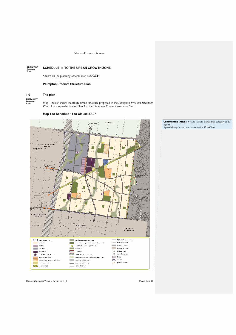
MELTON PLANNING SCHEME
URBAN GROWTH ZONE – SCHEDULE 11 PAGE 1 OF 11
SCHEDULE 11 TO THE URBAN GROWTH ZONE
Shown on the planning scheme map as UGZ11.
Plumpton Precinct Structure Plan
1.0 The plan
Map 1 below shows the future urban structure proposed in the Plumpton Precinct Structure
Plan. It is a reproduction of Plan 3 in the Plumpton Precinct Structure Plan.
Map 1 to Schedule 11 to Clause 37.07
DD/MM/YYYY Proposed C146
DD/MM/YYYY Proposed C146
Commented [MR1]: VPA to include ‘Mixed Use’ category in the legend. Agreed change in response to submission 12 to C146
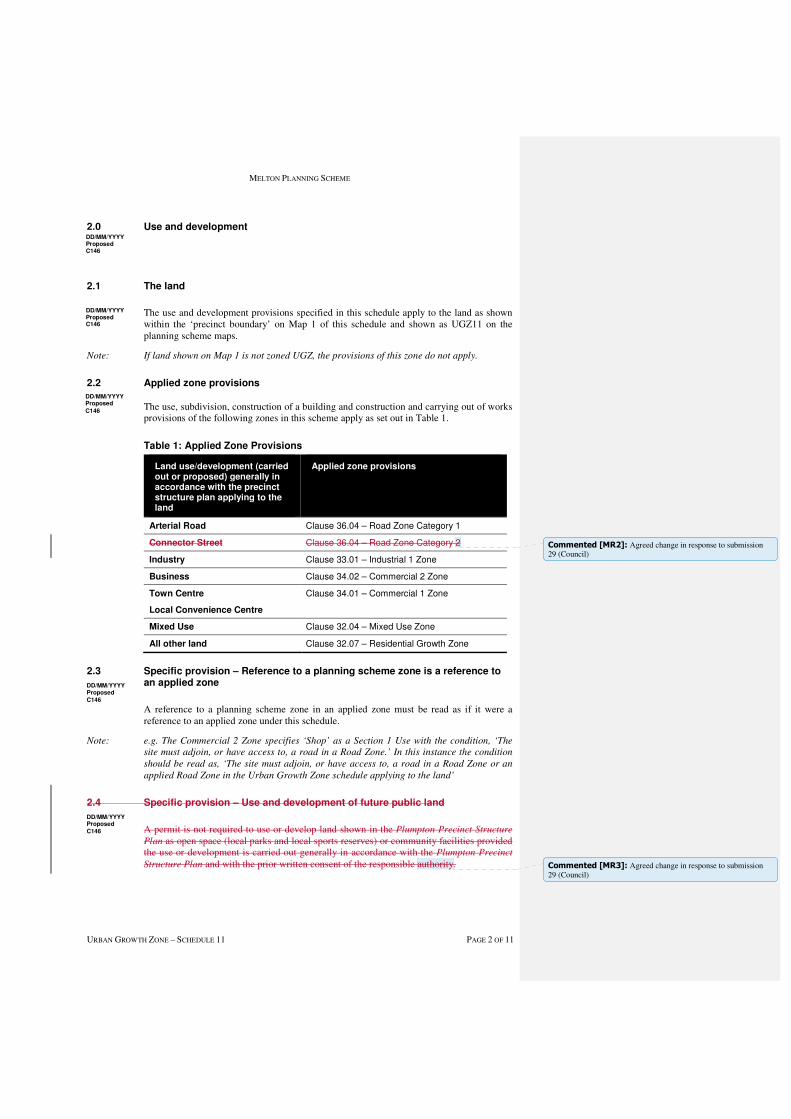
MELTON PLANNING SCHEME
URBAN GROWTH ZONE – SCHEDULE 11 PAGE 2 OF 11
2.0 Use and development
2.1 The land
The use and development provisions specified in this schedule apply to the land as shown within the ‘precinct boundary’ on Map 1 of this schedule and shown as UGZ11 on the planning scheme maps.
Note: If land shown on Map 1 is not zoned UGZ, the provisions of this zone do not apply.
2.2 Applied zone provisions
The use, subdivision, construction of a building and construction and carrying out of works provisions of the following zones in this scheme apply as set out in Table 1.
Table 1: Applied Zone Provisions
Land use/development (carried out or proposed) generally in accordance with the precinct structure plan applying to the land
Applied zone provisions
Arterial Road Clause 36.04 – Road Zone Category 1
Connector Street Clause 36.04 – Road Zone Category 2
Industry Clause 33.01 – Industrial 1 Zone
Business Clause 34.02 – Commercial 2 Zone
Town Centre
Local Convenience Centre
Clause 34.01 – Commercial 1 Zone
Mixed Use Clause 32.04 – Mixed Use Zone
All other land Clause 32.07 – Residential Growth Zone
2.3 Specific provision – Reference to a planning scheme zone is a reference to an applied zone
A reference to a planning scheme zone in an applied zone must be read as if it were a reference to an applied zone under this schedule.
Note: e.g. The Commercial 2 Zone specifies ‘Shop’ as a Section 1 Use with the condition, ‘The
site must adjoin, or have access to, a road in a Road Zone.’ In this instance the condition
should be read as, ‘The site must adjoin, or have access to, a road in a Road Zone or an
applied Road Zone in the Urban Growth Zone schedule applying to the land’
2.4 Specific provision – Use and development of future public land
A permit is not required to use or develop land shown in the Plumpton Precinct Structure
Plan as open space (local parks and local sports reserves) or community facilities provided the use or development is carried out generally in accordance with the Plumpton Precinct
Structure Plan and with the prior written consent of the responsible authority.
DD/MM/YYYY Proposed C146
DD/MM/YYYY Proposed C146
DD/MM/YYYY Proposed
C146
DD/MM/YYYY Proposed Cxx
DD/MM/YYYY Proposed
C146
DD/MM/YYYY Proposed Cxx
DD/MM/YYYY Proposed
C146
Commented [MR2]: Agreed change in response to submission 29 (Council)
Commented [MR3]: Agreed change in response to submission 29 (Council)
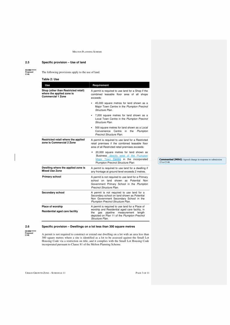
MELTON PLANNING SCHEME
URBAN GROWTH ZONE – SCHEDULE 11 PAGE 3 OF 11
2.5 Specific provision – Use of land
The following provisions apply to the use of land.
Table 2: Use
Use Requirement
Shop (other than Restricted retail) where the applied zone is Commercial 1 Zone
A permit is required to use land for a Shop if the
combined leasable floor area of all shops
exceeds:
� 45,000 square metres for land shown as a
Major Town Centre in the Plumpton Precinct
Structure Plan.
� 7,200 square metres for land shown as a
Local Town Centre in the Plumpton Precinct
Structure Plan.
� 500 square metres for land shown as a Local
Convenience Centre in the Plumpton
Precinct Structure Plan.
Restricted retail where the applied zone is Commercial 2 Zone
A permit is required to use land for a Restricted
retail premises if the combined leasable floor
area of all Restricted retail premises exceeds:
� 20,000 square metres for land shown as
‘Business’ directly west of the Plumpton
Major Town Centre in the incorporated
Plumpton Precinct Structure Plan
Dwelling where the applied zone is Mixed Use Zone
A permit is required to use land for a dwelling if
any frontage at ground level exceeds 2 metres.
Primary school
A permit is not required to use land for a Primary
school on land shown as Potential Non
Government Primary School in the Plumpton
Precinct Structure Plan.
Secondary school A permit is not required to use land for a Secondary school on land shown as Potential Non Government Secondary School in the Plumpton Precinct Structure Plan.
Place of worship
Residential aged care facility
A permit is required to use land for a Place of worship and Residential aged care facility, in the gas pipeline measurement length depicted on Plan 11 of the Plumpton Precinct Structure Plan.
2.6 Specific provision – Dwellings on a lot less than 300 square metres
A permit is not required to construct or extend one dwelling on a lot with an area less than 300 square metres where a site is identified as a lot to be assessed against the Small Lot Housing Code via a restriction on title, and it complies with the Small Lot Housing Code incorporated pursuant to Clause 81 of the Melton Planning Scheme.
DD/MM/YYYY Proposed C146
DD/MM/YYYY Proposed Cxx
DD/MM/YYYY Proposed
C146
Commented [MR4]: Agreed change in response to submission 15 to C146
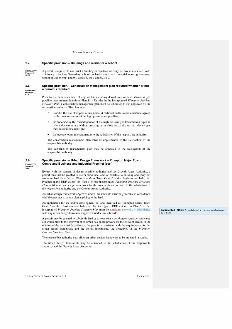
MELTON PLANNING SCHEME
URBAN GROWTH ZONE – SCHEDULE 11 PAGE 4 OF 11
2.7 Specific provision – Buildings and works for a school
A permit is required to construct a building or construct or carry out works associated with a Primary school or Secondary school on land shown as a potential non- government school unless exempt under Clauses 62.02-1 and 62.02-2.
2.8 Specific provision – Construction management plan required whether or not a permit is required
Prior to the commencement of any works, including demolition, on land shown as gas pipeline measurement length on Plan 11 – Utilities in the incorporated Plumpton Precinct
Structure Plan, a construction management plan must be submitted to and approved by the responsible authority. The plan must:
• Prohibit the use of rippers or horizontal directional drills unless otherwise agreed by the owner/operator of the high pressure gas pipeline;
• Be endorsed by the owner/operator of the high pressure gas transmission pipeline where the works are within, crossing or in close proximity to the relevant gas transmission easement; and
• Include any other relevant matter to the satisfaction of the responsible authority.
The construction management plan must be implemented to the satisfaction of the responsible authority.
The construction management plan may be amended to the satisfaction of the responsible authority.
2.9 Specific provision – Urban Design Framework – Plumpton Major Town Centre and Business and Industrial Precinct (part)
Except with the consent of the responsible authority and the Growth Areas Authority, a permit must not be granted to use or subdivide land, or construct a building and carry out works on land identified as ‘Plumpton Major Town Centre’ or the ‘Business and Industrial Precinct (part) UDF extent’ on Plan 5 in the incorporated Plumpton Precinct Structure
Plan, until an urban design framework for the area has been prepared to the satisfaction of the responsible authority and the Growth Areas Authority.
An urban design framework approved under this schedule must be generally in accordance with the precinct structure plan applying to the land.
An application for use and/or development on land identified as ‘Plumpton Major Town Centre’ or the ‘Business and Industrial Precinct (part) UDF extent’ on Plan 5 in the incorporated Plumpton Precinct Structure Plan must be consistent generally in accordance with any urban design framework approved under this schedule.
A permit may be granted to subdivide land or to construct a building or construct and carry out works prior to the approval of an urban design framework for the relevant area if, in the opinion of the responsible authority, the permit is consistent with the requirements for the urban design framework and the permit implements the objectives in the Plumpton
Precinct Structure Plan.
The responsible authority may allow an urban design framework to be prepared in stages.
The urban design framework may be amended to the satisfaction of the responsible authority and the Growth Areas Authority.
DD/MM/YYYY Proposed C146
DD/MM/YYYY Proposed C146
DD/MM/YYYY Proposed C146
Commented [MR5]: Agreed change in response to submission 12 to C146
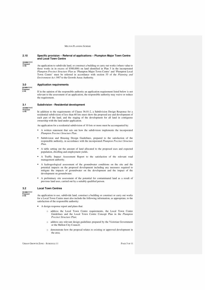
MELTON PLANNING SCHEME
URBAN GROWTH ZONE – SCHEDULE 11 PAGE 5 OF 11
2.10 Specific provision – Referral of applications – Plumpton Major Town Centre and Local Town Centre
An application to subdivide land, or construct a building or carry out works (where value to those works in in excess of $500,000) on land identified in Plan 5 in the incorporated Plumpton Precinct Structure Plan as ‘Plumpton Major Town Centre’ and ‘Plumpton Local Town Centre’ must be referred in accordance with section 55 of the Planning and
Environment Act 1987 to the Growth Areas Authority.
3.0 Application requirements
If in the opinion of the responsible authority an application requirement listed below is not relevant to the assessment of an application, the responsible authority may waive or reduce the requirement.
3.1 Subdivision - Residential development
In addition to the requirements of Clause 56.01-2, a Subdivision Design Response for a residential subdivision of less than 60 lots must show the proposed use and development of each part of the land, and the staging of the development for all land in contiguous ownership with the land under application.
An application for a residential subdivision of 10 lots or more must be accompanied by:
� A written statement that sets out how the subdivision implements the incorporated Plumpton Precinct Structure Plan.
� Subdivision and Housing Design Guidelines, prepared to the satisfaction of the responsible authority, in accordance with the incorporated Plumpton Precinct Structure
Plan.
� A table setting out the amount of land allocated to the proposed uses and expected population, dwelling and employment yields.
� A Traffic Impact Assessment Report to the satisfaction of the relevant road management authority.
� A hydrogeological assessment of the groundwater conditions on the site and the potential impacts on the proposed development including any measures required to mitigate the impacts of groundwater on the development and the impact of the development on groundwater.
� A preliminary site assessment of the potential for contaminated land as a result of previous land uses, carried out by a suitably qualified person.
3.2 Local Town Centres
An application to use, subdivide land, construct a building or construct or carry out works for a Local Town Centre must also include the following information, as appropriate, to the satisfaction of the responsible authority:
• A design response report and plans that:
o address the Local Town Centre requirements, the Local Town Centre Guidelines and the Local Town Centre Concept Plan in the Plumpton
Precinct Structure Plan;
o address any relevant design guidelines prepared by the Victorian Government or the Melton City Council;
o demonstrate how the proposal relates to existing or approved development in the area;
DD/MM/YYYY Proposed C146
DD/MM/YYYY Proposed C146
DD/MM/YYYY Proposed C146
DD/MM/YYYY Proposed C146
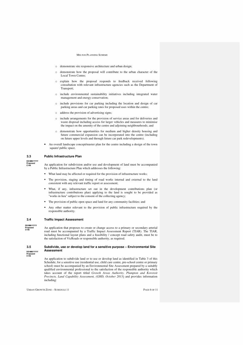
MELTON PLANNING SCHEME
URBAN GROWTH ZONE – SCHEDULE 11 PAGE 6 OF 11
o demonstrate site responsive architecture and urban design;
o demonstrate how the proposal will contribute to the urban character of the Local Town Centre;
o explain how the proposal responds to feedback received following consultation with relevant infrastructure agencies such as the Department of Transport;
o include environmental sustainability initiatives including integrated water management and energy conservation;
o include provisions for car parking including the location and design of car parking areas and car parking rates for proposed uses within the centre;
o address the provision of advertising signs;
o include arrangements for the provision of service areas and for deliveries and waste disposal including access for larger vehicles and measures to minimise the impact on the amenity of the centre and adjoining neighbourhoods; and
o demonstrate how opportunities for medium and higher density housing and future commercial expansion can be incorporated into the centre (including on future upper levels and through future car park redevelopments).
• An overall landscape concept/master plan for the centre including a design of the town square/ public space.
3.3 Public Infrastructure Plan
An application for subdivision and/or use and development of land must be accompanied by a Public Infrastructure Plan which addresses the following:
� What land may be affected or required for the provision of infrastructure works;
� The provision, staging and timing of road works internal and external to the land consistent with any relevant traffic report or assessment;
� What, if any, infrastructure set out in the development contributions plan (or infrastructure contributions plan) applying to the land is sought to be provided as "works in lieu" subject to the consent of the collecting agency;
� The provision of public open space and land for any community facilities; and
� Any other matter relevant to the provision of public infrastructure required by the responsible authority.
3.4 Traffic Impact Assessment
An application that proposes to create or change access to a primary or secondary arterial road must be accompanied by a Traffic Impact Assessment Report (TIAR). The TIAR, including functional layout plans and a feasibility / concept road safety audit, must be to the satisfaction of VicRoads or responsible authority, as required.
3.5 Subdivide, use or develop land for a sensitive purpose – Environmental Site Assessment
An application to subdivide land or to use or develop land as identified in Table 3 of this Schedule, for a sensitive use (residential use, child care centre, pre-school centre or primary school) must be accompanied by an Environmental Site Assessment prepared by a suitably qualified environmental professional to the satisfaction of the responsible authority which takes account of the report titled Growth Areas Authority, Plumpton and Kororoit
Precincts, Land Capability Assessment, (GHD, October 2013) and provides information including:
DD/MM/YYYY Proposed C146
DD/MM/YYYY Proposed C146
DD/MM/YYYY Proposed C146
MELTON PLANNING SCHEME
URBAN GROWTH ZONE – SCHEDULE 11 PAGE 7 OF 11
� Further detailed assessment of potential contaminants on the relevant land;
� Clear advice on whether the environmental condition of the land is suitable for the proposed use/s and whether an environmental audit of all, or part, of the land is recommended having regard to the Potentially Contaminated Land General Practice
Note June 2005, DSE;
� Further detailed assessment of surface and subsurface water conditions and geotechnical characteristics (including soil and groundwater sampling) on the relevant land and the potential impacts on the proposed development including any measures required to mitigate the impacts of groundwater conditions and geology on the development and the impact of the development on surface and subsurface water; and
� Recommended remediation actions for any potentially contaminated land.
Table 3: Environmental Site Assessment
Address Legal Description
1048 Taylors Road, Plumpton Lot 1 on PS709426
1052 Taylors Road, Plumpton Lot 1 on PS604066
4.0 Conditions and requirements for permits
4.1 Conditions for subdivision permits that allows the creation of a lot less than 300 square metres
Any permit for subdivision that allows the creation of a lot less than 300 square metres must contain the following conditions:
� Prior to the certification of the plan of subdivision for the relevant stage, a plan must be submitted for approval to the satisfaction of the responsible authority. The plan must identify the lots that will include a restriction on title allowing the use of the provisions of the Small Lot Housing Code incorporated pursuant to Clause 81 of the Melton Planning Scheme; and
� The plan of subdivision submitted for certification must identify whether type A or type B of the Small Lot Housing Code applies to each lot to the satisfaction of the responsible authority.
4.2 Conditions for subdivision or buildings and works permits where land is required for community facilities, public open space and road widening
Land required for community facilities or public open space shown as ‘credited open space’, as set out in the Plumpton Precinct Structure Plan or the Plumpton and Kororoit
Infrastructure Contributions Plan must be transferred to or vested in Council at no cost to Council unless the land is funded by the Plumpton and Kororoit Infrastructure
Contributions Plan.
Land required for road widening including right of way flaring for the ultimate design of any intersection with an existing or proposed arterial road must be transferred to or vested in Council or VicRoads at no cost to the acquiring agency unless funded by the Plumpton
and Kororoit Infrastructure Contributions Plan.
Land required for a community facility, road, or public open space must be on a Plan of Subdivision submitted for Certification as a reserve in favour of Melton City Council or the relevant agency, at no cost to Council or the relevant agency.
DD/MM/YYYY Proposed C146
DD/MM/YYYY Proposed C146
DD/MM/YYYY Proposed C146

MELTON PLANNING SCHEME
URBAN GROWTH ZONE – SCHEDULE 11 PAGE 8 OF 11
4.3 Condition - Kangaroo Management
A permit granted for subdivision of land must include the following conditions:
� Before the certification of the Plan of Subdivision, a Kangaroo Management Plan must be approved by the Secretary to the Department of Environment, Land, Water and Planning. Once approved the plan will be endorsed by the responsible authority and form part of the permit.The endorsed Kangaroo Management Plan must be implemented to the satisfaction of the responsible authority.
4.4 Requirement - Salvage and Translocation
Salvage and translocation of threatened flora and fauna species and ecological communities must be undertaken in the carrying out of development to the satisfaction of the Secretary of the Department of Environment, Land, Water and Planning.
4.5 Requirement - Protection of conservation areas and native vegetation during construction
A permit granted to subdivide land where construction or works are required to carry out the subdivision, or a permit granted to construct a building or carry out works, on land including or abutting a conservation area or patch of native vegetation or scattered tree identified for retention in the incorporated Plumpton Precinct Structure Plan must ensure that:
� Before the start of construction or carrying out of works in or around a conservation area, scattered native tree or patch of native vegetation the developer of the land must erect a conservation area/vegetation protection fence that is:
� highly visible
� at least 2 metres in height
� sturdy and strong enough to withstand knocks from construction vehicles
� in place for the whole period of construction
� located the following minimum distance from the element to be protected:
ELEMENT MINIMUM DISTANCE FROM ELEMENT
Conservation area 2 metres
Scattered tree Twice the distance between the tree trunk and the edge of the
tree canopy
Patch of native
vegetation
2 metres
� Construction stockpiles, fill, machinery, excavation and works or other activities associated with the buildings or works must:
� be located not less than 15 metres from a waterway;
� be located outside the vegetation protection fence;
� be constructed and designed to ensure that the conservation area, scattered tree or
patches of native vegetation are protected from adverse impacts during
construction;
� not be undertaken if it presents a risk to any vegetation within a conservation area;
and
DD/MM/YYYY Proposed C146
DD/MM/YYYY Proposed C146
D/MM/YYYY Proposed C146
MELTON PLANNING SCHEME
URBAN GROWTH ZONE – SCHEDULE 11 PAGE 9 OF 11
� be carried out under the supervision of a suitable qualified ecologist or arborist.
4.6 Management of bushfire risk during subdivisional works
A permit for subdivision that contains a condition requiring a construction management or site management plan must ensure that the relevant plan addresses any potential bushfire risks arising from the land during construction and must include a statement from a suitably qualified professional that the proposed bushfire risk management measures are appropriate.
4.7 Condition for public transport
Unless otherwise agreed to by Public Transport Victoria, prior to the issue of a statement of compliance for any subdivision stage, bus stops must be constructed, at full cost to the permit holder as follows:
� Generally in the location identified by Public Transport Victoria
� In accordance with the Public Transport Guidelines for Land Use and Development with a concrete hard stand area, and in activity centres a shelter must also be constructed
� Be compliant with the Disability Discrimination Act – Disability Standards for
Accessible Public Transport 2002; and
� Be provided with direct and safe pedestrian access to a pedestrian path.
All to the satisfaction of Public Transport Victoria and the responsible authority.
4.8 Condition – Environmental Site Assessment
Any permit for the use and development of land, as listed in Table 3 of this schedule, for a sensitive use (residential use, child care centre, pre-school centre or primary school) must contain the following conditions:
• Before the commencement of the development of the land, the recommendations of the Environmental Site Assessment submitted with the application must be carried out to the satisfaction of the responsible authority.
• Upon receipt of the further testing report the owner must comply with any further requirements made by the responsible authority after having regard to the guidance set out in the General Practice Note on Potentially Contaminated Land
June 2005 (DSE). The plan of subdivision must not be certified until the responsible authority is satisfied that the land is suitable for the intended use.
Any permit for the subdivision of land listed in Table 3 of this schedule must contain the following conditions:
• Before a plan subdivision is certified under the Subdivision Act 1988, the recommendations of the Environmental Site Assessment submitted with the application must be carried out to the satisfaction of the responsible authority.
• Upon receipt of the further testing report the owner must comply with any further requirements made by the responsible authority after having regard to the guidance set out in the General Practice Note on Potentially Contaminated Land
June 2005 (DSE). The plan of subdivision must not be certified until the responsible authority is satisfied that the land is suitable for the intended use.
DD/MM/YYYY Proposed C146
DD/MM/YYYY Proposed C146
DD/MM/YYYY Proposed C146
MELTON PLANNING SCHEME
URBAN GROWTH ZONE – SCHEDULE 11 PAGE 10 OF 11
5.0 Advertising Signs
Land is in the category specified in the applied zone.
5.1 Land and home sales signs
Despite the provisions of Clause 52.05, signs promoting the sale of land or homes on the land (or on adjoining land in the same ownership) may be displayed without a permit provided:
� The advertisement area for each sign does not exceed 10 square metres;
� Only one sign is displayed per road frontage. Where the property has a road frontage of more than 150 metres multiple signs may be erected provided there is a minimum of 150 metres distance between each sign, with a total of not more than 4 signs per frontage;
� The sign is not animated, scrolling, electronic or internally illuminated sign;
� The sign is not displayed longer than 21 days after the sale (not settlement) of the last lot.; and
� The sign is setback a minimum of 750mm from the property boundary.
A permit may be granted to display a sign promoting the sale of land or homes on the land (or on adjoining land in the same ownership) with an area greater than 10 square metres.
If the sign does not meet all of the requirements listed above, it must comply with the provisions of Clause 52.05.
5.2 Education / community promotion signs
Despite the provisions of Clause 52.05, a permit may be granted, for a period of not more than 5 years, to display an advertising sign greater than two square metres in area that promotes a community facility or education centre on the land identified as community facilities, potential government school, potential non-government school and credited open space on Map 1 to this schedule.
6.0 Notice to gas transmission pipeline owner and operator
Notice must be given to the person or body listed in the Schedule to Clause 66.06 of an application to use land for any of the following within the ‘gas pipeline measurement length’ shown on Plan 11 Utilities in the incorporated Plumpton Precinct Structure Plan
� Child care centre
� Cinema
� Education centre
� Hospital
� Residential aged care facility
� Corrective institution
� Place of assembly
Notice must be given to the person or body listed in the Schedule to Clause 66.06 of an application for a residential development of four or more storeys within the ‘high pressure gas transmission pipeline measurement length’ shown on Plan 11 Utilities in the incorporated Plumpton Precinct Structure Plan.
DD/MM/YYYY Proposed C146
DD/MM/YYYY Proposed C146
DD/MM/YYYY Proposed C146
DD/MM/YYYY Proposed C146
MELTON PLANNING SCHEME
URBAN GROWTH ZONE – SCHEDULE 11 PAGE 11 OF 11
7.0 Decision Guidelines
Before deciding on an application to use land for a shop in a town centre, in addition to the decision guidelines at Clause 37.07-14, the responsible authority must consider, as appropriate:
� The local catchment and PSP catchment demand for the additional floor area; and
� The effect on existing and future major town centres within City of Melton.
8.0 Exemption from notice and review not to apply to certain applications
An application to use land for a use listed in Section 2 of the Residential Growth Zone on land where the applied zone listed at Table 1 of this schedule is Residential Growth Zone is not exempt from the notice requirements of section 52(1)(a), (b) and (d), the decision requirements of section 64(1), (2) and (3) and the review rights of section 82(1) of the Act.
DD/MM/YYYY Proposed C146
DD/MM/YYYY Proposed C146
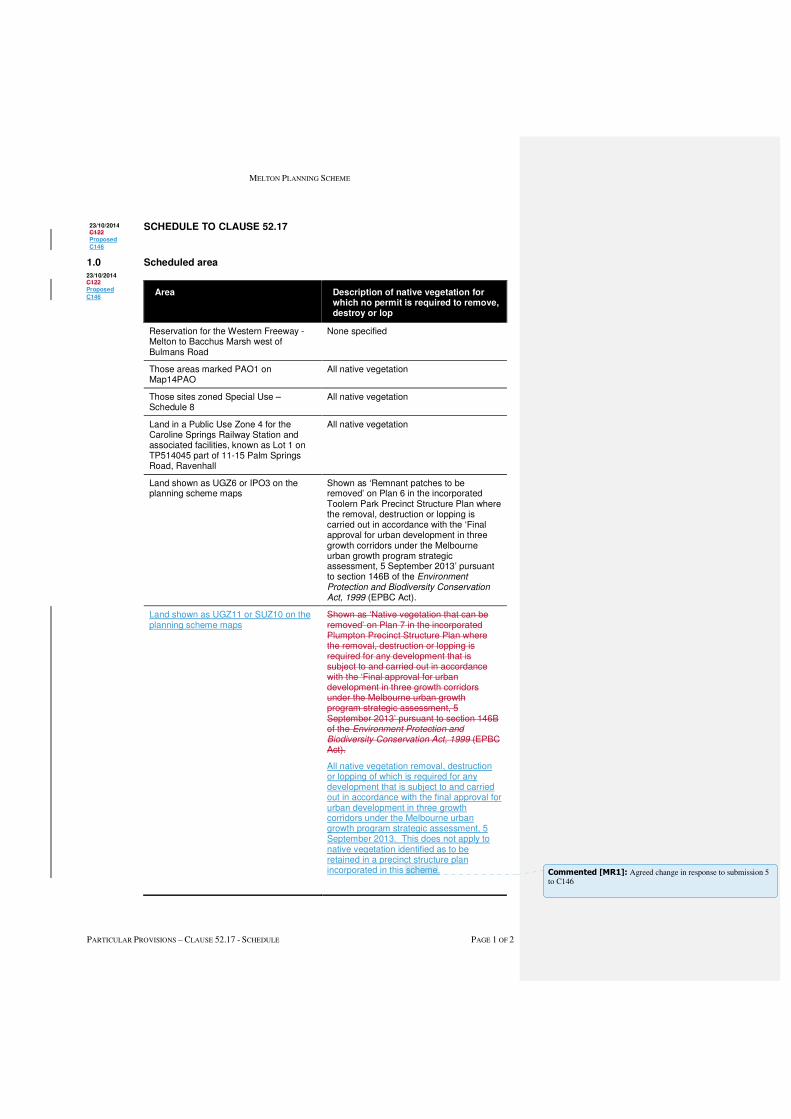
MELTON PLANNING SCHEME
PARTICULAR PROVISIONS – CLAUSE 52.17 - SCHEDULE PAGE 1 OF 2
SCHEDULE TO CLAUSE 52.17
1.0 Scheduled area
Area Description of native vegetation for which no permit is required to remove, destroy or lop
Reservation for the Western Freeway - Melton to Bacchus Marsh west of Bulmans Road
None specified
Those areas marked PAO1 on Map14PAO
All native vegetation
Those sites zoned Special Use – Schedule 8
All native vegetation
Land in a Public Use Zone 4 for the Caroline Springs Railway Station and associated facilities, known as Lot 1 on TP514045 part of 11-15 Palm Springs Road, Ravenhall
All native vegetation
Land shown as UGZ6 or IPO3 on the planning scheme maps
Shown as ‘Remnant patches to be removed’ on Plan 6 in the incorporated Toolern Park Precinct Structure Plan where the removal, destruction or lopping is carried out in accordance with the ‘Final approval for urban development in three growth corridors under the Melbourne urban growth program strategic assessment, 5 September 2013’ pursuant to section 146B of the Environment Protection and Biodiversity Conservation Act, 1999 (EPBC Act).
Land shown as UGZ11 or SUZ10 on the planning scheme maps
Shown as ‘Native vegetation that can be removed’ on Plan 7 in the incorporated Plumpton Precinct Structure Plan where the removal, destruction or lopping is required for any development that is subject to and carried out in accordance with the ‘Final approval for urban development in three growth corridors under the Melbourne urban growth program strategic assessment, 5 September 2013’ pursuant to section 146B of the Environment Protection and Biodiversity Conservation Act, 1999 (EPBC Act).
All native vegetation removal, destruction or lopping of which is required for any development that is subject to and carried out in accordance with the final approval for urban development in three growth corridors under the Melbourne urban growth program strategic assessment, 5 September 2013. This does not apply to native vegetation identified as to be retained in a precinct structure plan incorporated in this scheme.
23/10/2014 C122 Proposed
C146
23/10/2014 C122 Proposed
C146
Commented [MR1]: Agreed change in response to submission 5 to C146
MELTON PLANNING SCHEME
PARTICULAR PROVISIONS – CLAUSE 52.17 - SCHEDULE PAGE 2 OF 2
2.0 Scheduled weed
Area Description of weed
None specified
3.0 Utility installation code of practice
Name of code of practice
None specified
15/09/2008 VC49
15/09/2008
VC49

MELTON PLANNING SCHEME
GENERAL PROVISIONS - CLAUSE 66.06 - SCHEDULE PAGE 1 OF 1
SCHEDULE TO CLAUSE 66.06
Notice of permit applications under local provisions
Clause Kind of application Person or body to be
notified
None specified
Clause 6.0 of
Schedule 11 to
Clause 37.07 (UGZ)
Any application specified under Clause 6
of Schedule 11 to Clause 37.07.
The licensee and/or
operator of the
Derrimut to Sunbury
pipeline and Truganina
to Plumpton
transmission gas
pipeline.
The licensee and/or
operator of the
Derrimut to Sunbury
pipeline and Truganina
to Plumpton
transmission pipeline
and Plumpton Gas
City Gate.
19/01/2006 VC37
C146
Commented [MR1]: Agreed change in response to submission 31 to C146.

Melton C146 & C147 | VPA submission to Planning Panels Victoria | November 2016
PART A | Summary of Submission Page 69 of 88
APPENDIX 6 Kororoit PSP Planning Scheme ordinances track changes
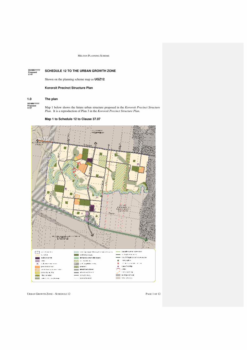
MELTON PLANNING SCHEME
URBAN GROWTH ZONE – SCHEDULE 12 PAGE 1 OF 12
SCHEDULE 12 TO THE URBAN GROWTH ZONE
Shown on the planning scheme map as UGZ12.
Kororoit Precinct Structure Plan
1.0 The plan
Map 1 below shows the future urban structure proposed in the Kororoit Precinct Structure
Plan. It is a reproduction of Plan 3 in the Kororoit Precinct Structure Plan.
Map 1 to Schedule 12 to Clause 37.07
DD/MM/YYYY Proposed C147
DD/MM/YYYY Proposed C147
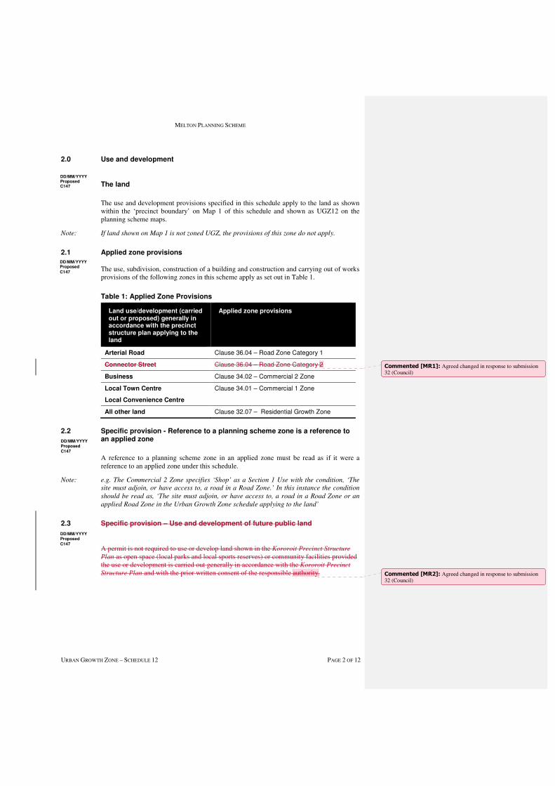
MELTON PLANNING SCHEME
URBAN GROWTH ZONE – SCHEDULE 12 PAGE 2 OF 12
2.0 Use and development
The land
The use and development provisions specified in this schedule apply to the land as shown within the ‘precinct boundary’ on Map 1 of this schedule and shown as UGZ12 on the planning scheme maps.
Note: If land shown on Map 1 is not zoned UGZ, the provisions of this zone do not apply.
2.1 Applied zone provisions
The use, subdivision, construction of a building and construction and carrying out of works provisions of the following zones in this scheme apply as set out in Table 1.
Table 1: Applied Zone Provisions
Land use/development (carried out or proposed) generally in accordance with the precinct structure plan applying to the land
Applied zone provisions
Arterial Road Clause 36.04 – Road Zone Category 1
Connector Street Clause 36.04 – Road Zone Category 2
Business Clause 34.02 – Commercial 2 Zone
Local Town Centre
Local Convenience Centre
Clause 34.01 – Commercial 1 Zone
All other land Clause 32.07 – Residential Growth Zone
2.2 Specific provision - Reference to a planning scheme zone is a reference to an applied zone
A reference to a planning scheme zone in an applied zone must be read as if it were a reference to an applied zone under this schedule.
Note: e.g. The Commercial 2 Zone specifies ‘Shop’ as a Section 1 Use with the condition, ‘The
site must adjoin, or have access to, a road in a Road Zone.’ In this instance the condition
should be read as, ‘The site must adjoin, or have access to, a road in a Road Zone or an
applied Road Zone in the Urban Growth Zone schedule applying to the land’
2.3 Specific provision – Use and development of future public land
A permit is not required to use or develop land shown in the Kororoit Precinct Structure
Plan as open space (local parks and local sports reserves) or community facilities provided the use or development is carried out generally in accordance with the Kororoit Precinct
Structure Plan and with the prior written consent of the responsible authority.
DD/MM/YYYY Proposed C147
DD/MM/YYYY Proposed
C147
DD/MM/YYYY Proposed Cxx
DD/MM/YYYY Proposed
C147
DD/MM/YYYY Proposed
C147
Commented [MR1]: Agreed changed in response to submission 32 (Council)
Commented [MR2]: Agreed changed in response to submission 32 (Council)

MELTON PLANNING SCHEME
URBAN GROWTH ZONE – SCHEDULE 12 PAGE 3 OF 12
2.4 Specific provision – Use of land
The following provisions apply to the use of land.
Table 2: Use
Use Requirement
Shop where the applied zone is Commercial 1 Zone
A permit is required to use land for a Shop if the
combined leasable floor area of all shops
exceeds:
� 7,100 square metres for land shown as
Kororoit Local Town Centre in the Kororoit
Precinct Structure Plan.
� 6,000 square metres for land shown as
Deanside Local Town Centre in the Kororoit
Precinct Structure Plan.
� 500 square metres for land shown as a Local
Convenience Centre in the Kororoit Precinct
Structure Plan.
Restricted retail where the applied zone is Commercial 2 Zone
A permit is required to use land for a Restricted
retail premises if the combined leasable floor
area of all restricted retail premises exceeds:
� 3,000 square metres for land shown as
Business in the incorporated Kororoit
Precinct Structure Plan
Primary school
A permit is not required to use land for a Primary
school on land shown as Potential Non
Government Primary School in the Kororoit
Precinct Structure Plan
Place of worship
Residential aged care facility
A permit is required to use land for a Place of worship and Residential aged care facility, in the high pressure gas transmission pipeline measurement length depicted on Plan 11 of the Kororoit Precinct Structure Plan.
2.5 Specific provision – Dwellings on a lot less than 300 square metres
A permit is not required to construct or extend one dwelling on a lot with an area less than 300 square metres where a site is identified as a lot to be assessed against the Small Lot Housing Code via a restriction on title, and it complies with the Small Lot Housing Code incorporated pursuant to Clause 81 of the Melton Planning Scheme.
2.6 Specific provision – Buildings and works for a school
A permit is required to construct a building or construct or carry out works associated with a Primary school or Secondary school on land shown as a non- government school unless exempt under Clauses 62.02-1 and 62.02-2.
DD/MM/YYYY Proposed C147
DD/MM/YYYY Proposed C147
DD/MM/YYYY Proposed
C147
MELTON PLANNING SCHEME
URBAN GROWTH ZONE – SCHEDULE 12 PAGE 4 OF 12
2.7 Specific provision – construction management plan required whether or not a permit is required
Prior to the commencement of any works, including demolition, on land shown as ‘gas pipeline measurement length’ on Plan 11 – Utilities in the Incorporated Kororoit Precinct
Structure Plan, a construction management plan must be submitted to and approved by the responsible authority. The plan must:
• Prohibit the use of rippers or horizontal directional drills unless otherwise agreed by the owner/operator of the high pressure gas pipeline;
• Be endorsed by the owner/operator of the high pressure gas transmission pipeline where the works are within, crossing or in close proximity to the relevant gas transmission easement; and
• Include any other relevant matter to the satisfaction of the responsible authority.
The construction management plan must be implemented to the satisfaction of the responsible authority.
The construction management plan may be amended to the satisfaction of the responsible authority.
2.98 Specific provision – Referral of applications – Local Town Centre
An application to subdivide land, or construct a building or carry out works (where value to those works in in excess of $500,000) on land identified in Plan 5 in the incorporated Kororoit Precinct Structure Plan as ‘Kororoit Local Town Centre’ and ‘Deanside Local Town Centre’ must be referred in accordance with section 55 of the Planning and
Environment Act 1987 to the Growth Areas Authority.
3.0 Application requirements
If in the opinion of the responsible authority an application requirement listed below is not relevant to the assessment of an application, the responsible authority may waive or reduce the requirement.
3.1 Subdivision - Residential development
In addition to the requirements of Clause 56.01-2, a Subdivision Design Response for a residential subdivision of less than 60 lots must show the proposed use and development of each part of the land, and the staging of the development for all land in contiguous ownership with the land under application.
An application for a residential subdivision of 10 lots or more must be accompanied by:
� A written statement that sets out how the subdivision implements the incorporated Kororoit Precinct Structure Plan.
� Subdivision and Housing Design Guidelines, prepared to the satisfaction of the responsible authority, in accordance with the incorporated Kororoit Precinct Structure
Plan.
� A table setting out the amount of land allocated to the proposed uses and expected population, dwelling and employment yields.
� A Traffic Impact Assessment Report to the satisfaction of the relevant road management authority.
� A hydrogeological assessment of the groundwater conditions on the site and the potential impacts on the proposed development including any measures required to mitigate the impacts of groundwater on the development and the impact of the development on groundwater.
DD/MM/YYYY Proposed C147
DD/MM/YYYY Proposed
C147
DD/MM/YYYY Proposed C147
DD/MM/YYYY Proposed C147
Commented [MR3]: Agreed change in response to submission 9 to C147

MELTON PLANNING SCHEME
URBAN GROWTH ZONE – SCHEDULE 12 PAGE 5 OF 12
� A preliminary site assessment of the potential for contaminated land as a result of previous land uses, carried out by a suitably qualified person.
3.2 Local Town Centres
An application to use, subdivide land, construct a building or construct or carry out works for a Local Town Centre must also include the following information, as appropriate, to the satisfaction of the responsible authority:
• A design response report and plans that:
o address the Local Town Centre requirements, the Local Town Centre Guidelines and the relevant Local Town Centre Concept Plan in the Kororoit
Precinct Structure Plan;
o address any relevant design guidelines prepared by the Victorian Government or the Melton City Council;
o demonstrate how the proposal relates to existing or approved development in the area;
o demonstrate site responsive architecture and urban design;
o demonstrate how the proposal will contribute to the urban character of the Local Town Centre;
o explain how the proposal responds to feedback received following consultation with relevant infrastructure agencies such as the Department of Transport;
o include environmental sustainability initiatives including integrated water management and energy conservation;
o include provisions for car parking including the location and design of car parking areas and car parking rates for proposed uses within the centre;
o address the provision of advertising signs;
o include arrangements for the provision of service areas and for deliveries and waste disposal including access for larger vehicles and measures to minimise the impact on the amenity of the centre and adjoining neighbourhoods; and
o demonstrate how opportunities for medium and higher density housing and future commercial expansion can be incorporated into the centre (including on future upper levels and through future car park redevelopments).
• An overall landscape concept/master plan for the centre including a design of the town square/ public space.
3.3 Public Infrastructure Plan
An application for subdivision and/or use and development of land must be accompanied by a Public Infrastructure Plan which addresses the following:
� What land may be affected or required for the provision of infrastructure works;
� The provision, staging and timing of road works internal and external to the land consistent with any relevant traffic report or assessment;
� What, if any, infrastructure set out in the development contributions plan (or infrastructure contributions plan) applying to the land is sought to be provided as "works in lieu" subject to the consent of the collecting agency;
� The provision of public open space and land for any community facilities; and
DD/MM/YYYY Proposed C147
DD/MM/YYYY Proposed C147
MELTON PLANNING SCHEME
URBAN GROWTH ZONE – SCHEDULE 12 PAGE 6 OF 12
� Any other matter relevant to the provision of public infrastructure required by the responsible authority.
3.4 Traffic Impact Assessment
An application that proposes to create or change access to a primary or secondary arterial road must be accompanied by a Traffic Impact Assessment Report (TIAR). The TIAR, including functional layout plans and a feasibility / concept road safety audit, must be to the satisfaction of VicRoads or responsible authority, as required.
3.5 Subdivide, use or develop land for a sensitive purpose - Environmental Site Assessment
An application to subdivide land, use or develop land as identified in Table 3 of this schedule, for a sensitive use (residential use, child care centre, pre-school centre or primary school) must be accompanied by an Environment Site Assessemnet by a suitably qualified environmental professional to the satisfaction of the responsible authority which takes account of the report titled Growth Areas Authority, Plumpton and Kororoit Precincts,
Land Capability Assessment, (GHD, October 2013) and provides information including:
� Further detailed assessment of potential contaminants on the relevant land;
� Clear advice on whether the environmental condition of the land is suitable for the proposed use/s and whether an environmental audit of all, or part, of the land is recommended having regard to the Potentially Contaminated Land General Practice
Note June 2005, DSE;
� Further detailed assessment of surface and subsurface water conditions and geotechnical characteristics (including soul and groundwater sampling) on the relevant land and the potential impacts on the proposed development including any measures required to mitigate the impacts of groundwater conditions and geology on the development and the impact of the development on surface and subsurface water; and
� Recommended remediation actions for any potentially contaminated land.
Table 3: Environmental Site Assessment
Address Legal Description
196 – 246 Sinclairs Road, Rockbank
Lot 1/LP48418
362 – 364 Sinclairs Road, Rockbank
Lot1/TP423084
1027 – 1051 Taylors Road, Plumpton
Lot2/LP208937
4.0 Conditions and requirements for permits
4.1 Conditions for subdivision permits that allows the creation of a lot less than 300 square metres
Any permit for subdivision that allows the creation of a lot less than 300 square metres must contain the following conditions:
� Prior to the certification of the plan of subdivision for the relevant stage, a plan must be submitted for approval to the satisfaction of the responsible authority. The plan must identify the lots that will include a restriction on title allowing the use of the provisions
DD/MM/YYYY Proposed C147
DD/MM/YYYY Proposed C147
DD/MM/YYYY Proposed C147
DD/MM/YYYY Proposed C147
MELTON PLANNING SCHEME
URBAN GROWTH ZONE – SCHEDULE 12 PAGE 7 OF 12
of the Small Lot Housing Code incorporated pursuant to Clause 81 of the Melton Planning Scheme; and
� The plan of subdivision submitted for certification must identify whether type A or type B of the Small Lot Housing Code applies to each lot to the satisfaction of the responsible authority.
4.2 Conditions for subdivision or buildings and works permits where land is required for community facilities, public open space and road widening
Land required for community facilities or public open space shown as ‘credited open space’, as set out in the Kororoit Precinct Structure Plan or the Plumpton and Kororoit
Infrastructure Contributions Plan must be transferred to or vested in Council at no cost to Council unless the land is funded by the Plumpton and Kororoit Infrastructure
Contributions Plan.
Land required for road widening including right of way flaring for the ultimate design of any intersection with an existing or proposed arterial road must be transferred to or vested in Council or VicRoads at no cost to the acquiring agency unless funded by the Plumpton
and Kororoit Infrastructure Contributions Plan.
Land required for a community facility, road, or public open space must be on a Plan of Subdivision submitted for Certification as a reserve in favour of Melton City Council or the relevant agency, at no cost to Council or the relevant agency.
4.3 Condition - Kangaroo Management
A permit granted for subdivision of land must include the following conditions:
� Before the certification of the Plan of Subdivision, a Kangaroo Management Plan must be approved by the Secretary to the Department of Environment, Land, Water and Planning.
� Once approved the plan will be endorsed by the responsible authority and form part of the permit.
4.4 Requirement - Salvage and Translocation
Salvage and translocation of threatened flora and fauna species and ecological communities must be undertaken in the carrying out of development to the satisfaction of the Secretary of the Department of Environment, Land, Water and Planning
4.5 Condition - Environmental Management Plan
A planning permit for subdivision, buildings or works on land shown as a conservation
area in the incorporated Kororoit Precinct Structure Plan must include the following
condition:
� The subdivision, buildings or works must not commence until an Environmental
Management Plan for the relevant works has been approved to the satisfaction of the
Department of Environment, Land, Water and Planning unless otherwise agreed by the
Department of Environment, Land, Water and Planning.
4.6 Requirement - Protection of conservation areas and native vegetation during construction
A permit granted to subdivide land where construction or works are required to carry out the subdivision, or a permit granted to construct a building or carry out works, on land including or abutting a conservation area or patch of native vegetation or scattered tree
DD/MM/YYYY Proposed C147
D/MM/YYYY Proposed C147
DD/MM/YYYY Proposed C147
D/MM/YYYY Proposed C147
DD/MM/YYYY Proposed C147
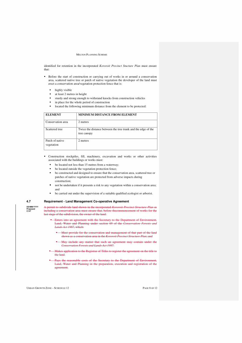
MELTON PLANNING SCHEME
URBAN GROWTH ZONE – SCHEDULE 12 PAGE 8 OF 12
identified for retention in the incorporated Kororoit Precinct Stucture Plan must ensure that:
� Before the start of construction or carrying out of works in or around a conservation area, scattered native tree or patch of native vegetation the developer of the land must erect a conservation area/vegetation protection fence that is:
� highly visible
� at least 2 metres in height
� sturdy and strong enough to withstand knocks from construction vehicles
� in place for the whole period of construction
� located the following minimum distance from the element to be protected:
ELEMENT MINIMUM DISTANCE FROM ELEMENT
Conservation area 2 metres
Scattered tree Twice the distance between the tree trunk and the edge of the
tree canopy
Patch of native
vegetation
2 metres
� Construction stockpiles, fill, machinery, excavation and works or other activities associated with the buildings or works must:
� be located not less than 15 metres from a waterway;
� be located outside the vegetation protection fence;
� be constructed and designed to ensure that the conservation area, scattered tree or
patches of native vegetation are protected from adverse impacts during
construction;
� not be undertaken if it presents a risk to any vegetation within a conservation area;
and
� be carried out under the supervision of a suitable qualified ecologist or arborist.
4.7 Requirement - Land Management Co-operative Agreement
A permit to subdivide land shown in the incorporated Kororoit Precinct Structure Plan as including a conservation area must ensure that, before thecommencement of works for the last stage of the subdivision, the owner of the land:
� Enters into an agreement with the Secretary to the Department of Environment, Land, Water and Planning under section 69 of the Conservation Forests and
Lands Act 1987, which:
� Must provide for the conservation and management of that part of the land shown as a conservation area in the Kororoit Precinct Structure Plan; and
� May include any matter that such an agreement may contain under the Conservation Forests and Lands Act 1987.
� Makes application to the Registrar of Titles to register the agreement on the title to the land.
� Pays the reasonable costs of the Secretary to the Department of Environment, Land, Water and Planning in the preparation, execution and registration of the agreement.
DD/MM/YYYY Proposed C147
MELTON PLANNING SCHEME
URBAN GROWTH ZONE – SCHEDULE 12 PAGE 9 OF 12
The requirement for a Land Management Co-operative Agreement in this condition does not apply to land or any lot or part of a lot within a conservation area identified in the Kororoit Precinct Structure Plan that:
� is identified in a Precinct Structure Plan as public open space and is vested, or will be vested, in the council as a reserve for the purposes of public open space; or
� is identified in a Precinct Structure Plan as a drainage reserve and is vested, or will be vested, in Melbourne Water Corporation or the council as a drainage reserve; or
� is within a Conservation Area identified in a Precinct Structure Plan for nature conservation and is vested, or will be vested, in the Secretary to the Department of Environment, Land, Water and Planning for conservation purposes; or
� is the subject of an agreement with the Secretary to the Department of Environment, Land, Water and Planning to transfer or gift that land to:
� the Secretary to the Department of Environment, Land, Water and Planning;
� the Minister for Environment and Climate Change; or
� another statutory authority.
to the satisfaction of the Secretary to the Department of Environment, Land, Water and Planning.
A permit to subdivide land shown in the incorporated Kororoit Precinct Structure Plan (‘the incorporated PSP’) as including a conservation area depicted in Appendix F must ensure that the owner of the land:
• Enters into a Land Management Cooperative Agreement (‘LMCA’) with the Secretary to the Department of Environment, Land, Water and Planning (‘DELWP’) under section 69 of the Conservation, Forests and Lands Act 1987, which:
- Must provide for the conservation and management of that part of the land shown as a conservation area in the incorporated PSP (‘a conservation area’);
- May include any matter that such an agreement may contain under the Conservation, Forests and Lands Act 1987;
• Makes application to the Registrar of Titles to register the agreement on the title to the land; and
• Pays the reasonable costs of the Secretary to the DELWP in the preparation, execution and registration of the agreement'.
'The Requirement for a LMCA in this condition does not apply to land or any lot or part of a lot within a conservation area that:
• is identified in the incorporated PSP as public open space and is vested, or will be vested, in the council as a reserve for the purposes of public open space; or
• is identified in the incorporated PSP as a drainage reserve and is vested, or will be vested, in Melbourne Water Corporation or the council as a drainage reserve; or
• is within a Conservation Area identified in the incorporated PSP for nature conservation and is vested, or is subject of an agreement with the Secretary to the DELWP to be vested in the Secretary to the DELWP for conservation purposes; or
• is the subject of an agreement with the Secretary to the DELWP to transfer or gift that land to: - the secretary to the DELWP; the Minister adminstering the Conservation,
Forests and Lands Act, 1987; or - another statutory authority' to the satisfaction of the Secretary to the DELWP.
The LMCA must be entered into: in relation to land containing Nature Conservation conservation area, prior to the commencement of works; or in relation to land containing Growling Grass Frog conservation area, before the issue of a statement of compliance for the last stage of the subdivision.
Commented [MR4]: Agreed change in response to submission 26 to C147

MELTON PLANNING SCHEME
URBAN GROWTH ZONE – SCHEDULE 12 PAGE 10 OF 12
4.8 Management of bushfire risk during subdivisional works
A permit for subdivision that contains a condition requiring a construction management or site management plan must ensure that the relevant plan addresses any potential bushfire risks arising from the land during construction and must include a statement from a suitably qualified professional that the proposed bushfire risk management measures are appropriate.
4.9 Condition for public transport
Unless otherwise agreed to by Public Transport Victoria, prior to the issue of a statement of compliance for any subdivision stage, bus stops must be constructed, at full cost to the permit holder as follows:
� Generally in the location identified by Public Transport Victoria
� In accordance with the Public Transport Victoria Guidelines for Land Use and
Development with a concrete hard stand area, and in activity centres a shelter must also be constructed
� Be compliant with the Disability Discrimination Act – Disability Standards for
Accessible Public Transport 2002; and
� Be provided with direct and safe pedestrian access to a pedestrian path.
All to the satisfaction of Public Transport Victoria and the responsible authority.
4.10 Conditions – Environmental Site Assessment
Any permit for the use and development of land, as listed in Table 3 of this schedule, for a sensitive use (residential use, child care centre, pre-school centre or primary school) must contain the following conditions:
• Before the commencement of the development of the land, the recommendations of the Environmental Site Assessment submitted with the application must be carried out to the satisfaction of the responsible authority.
• Upon receipt of the further testing report the owner must comply with any further requirements made by the responsible authority after having regard to the guidance set out in the General Practice Note on Potentially Contaminated Land
June 2005 (DSE). The plan of subdivision must not be certified until the responsible authority is satisfied that the land is suitable for the intended use.
Any permit for the subdivision of land listed in Table 3 of this schedule must contain the following conditions:
• Before a plan subdivision is certified under the Subdivision Act 1988, the recommendations of the Environmental Site Assessment submitted with the application must be carried out to the satisfaction of the responsible authority.
• Upon receipt of the further testing report the owner must comply with any further requirements made by the responsible authority after having regard to the guidance set out in the General Practice Note on Potentially Contaminated Land
June 2005 (DSE). The plan of subdivision must not be certified until the responsible authority is satisfied that the land is suitable for the intended use.
5.0 Advertising Signs
Land is in the category specified in the applied zone.
DD/MM/YYYY Proposed C147
DD/MM/YYYY Proposed C147
DD/MM/YYYY Proposed C147
DD/MM/YYYY Proposed C147
MELTON PLANNING SCHEME
URBAN GROWTH ZONE – SCHEDULE 12 PAGE 11 OF 12
5.1 Land and home sales signs
Despite the provisions of Clause 52.05, signs promoting the sale of land or homes on the land (or on adjoining land in the same ownership) may be displayed without a permit provided:
� The advertisement area for each sign does not exceed 10 square metres;
� Only one sign is displayed per road frontage. Where the property has a road frontage of more than 150 metres multiple signs may be erected provided there is a minimum of 150 metres distance between each sign, with a total of not more than 4 signs per frontage;
� The sign is not animated, scrolling, electronic or internally illuminated sign;
� The sign is not displayed longer than 21 days after the sale (not settlement) of the last lot.; and
� The sign is setback a minimum of 750mm from the property boundary.
A permit may be granted to display a sign promoting the sale of land or homes on the land (or on adjoining land in the same ownership) with an area greater than 10 square metres.If the sign does not meet all of the requirements listed above, it must comply with the provisions of Clause 52.05.
5.2 Education / community promotion signs
Despite the provisions of Clause 52.05, a permit may be granted, for a period of not more than 5 years, to display an advertising sign greater than two square metres in area that promotes a community facility or education centre on the land identified as community facilities, potential government school, potential non-government school and credited open space on Map 1 to this schedule.
6.0 Notice to gas transmission pipeline owner and operator
Notice must be given to the person or body listed in the Schedule to Clause 66.06 of an application to use land for any of the following within the ‘gas pipeline measurement length’ shown on Plan 11 Utilities in the incorporated Kororoit Precinct Structure Plan
� Child care centre
� Cinema
� Education centre
� Hospital
� Residential aged care facility
� Corrective institution
� Place of assembly
Notice must be given to the person or body listed in the Schedule to Clause 66.06 of an application for a residential development of four or more storeys within the ‘gas pipeline measurement length’ shown on Plan 11 Utilities in the incorporated Kororoit Precinct
Structure Plan
7.0 Decision Guidelines
Before deciding on an application to use land for a shop in a town centre, in addition to the decision guidelines at Clause 37.07-14, the responsible authority must consider, as appropriate:
DD/MM/YYYY Proposed C147
DD/MM/YYYY Proposed C147
DD/MM/YYYY Proposed C147
DD/MM/YYYY Proposed C147
MELTON PLANNING SCHEME
URBAN GROWTH ZONE – SCHEDULE 12 PAGE 12 OF 12
� The local catchment and PSP catchment demand for the additional floor area; and
� The effect on existing and future major town centres within City of Melton
8.0 Exemption from notice and review not to apply to certain applications
An application to use land for a use listed in Section 2 of the Residential Growth Zone on land where the applied zone listed at Table 1 of this schedule is Residential Growth Zone is not exempt from the notice requirements of section 52(1)(a), (b) and (d), the decision requirements of section 64(1), (2) and (3) and the review rights of section 82(1) of the Act.
DD/MM/YYYY Proposed C147

MELTON PLANNING SCHEME
ENVIRONMENTAL SIGNIFICANCE OVERLAY – SCHEDULE 6 PAGE 1 OF 4
SCHEDULE 6 TO THE ENVIRONMENTAL SIGNIFICANCE OVERLAY
Shown on the planning scheme map as ESO6.
RURAL URBAN CONSERVATION AREA
1.0 Statement of environmental significance
The development of Melbourne has caused significant impacts to the environment. Melbourne’s footprint has resulted in the removal of most native vegetation, and retained habitat areas only support flora and fauna that can survive in a highly fragmented and urbanised landscape. The overall biodiversity of Melbourne is a fraction of what it was prior to European settlement.
As part of the delivery of Melbourne's Newest Sustainable Communities Program, the Victorian Government established a process to identify, permanently protect and manage biodiversity assets that are important within the greater Melbourne region.
This process has determined the location of significant biodiversity assets and identified areas where these can be retained and where urban development is not appropriate and to which this overlay has been applied.
The areas covered by this overlay include some existing conservation reserves, areas of significant remnant native vegetation and a number of areas that provide habitat for threatened flora and fauna.
The areas include but are not limited to:
� Important grasslands.
� Grassy eucalypt woodlands.
� Waterways and riparian areas.
� Other important habitat for threatened flora and fauna.
It is important that these areas are retained and managed to ensure that their biodiversity values and any habitat links are protected and enhanced.
2.0 Environmental objective to be achieved
� To protect and improve the viability of habitats, ecological communities, flora and
fauna and genetic diversity.
� To enhance the environmental and landscape values of the area.
� To ensure that any use, development or management of land within and adjacent to
areas of biological significance are compatible with their long-term maintenance and
conservation and will not have detrimental impacts on biodiversity values.
� To encourage ecological restoration, regeneration and revegetation with indigenous
species within the site.
� To maintain and enhance habitat connectivity for listed threatened species.
� To prevent a decline in the extent and quality of native vegetation and native fauna
habitat.
� To ensure that the siting and design of any buildings and works maintains the
environmental integrity of the land.
DD/MM/YYYY Proposed C147
DD/MM/YYYY Proposed C147
DD/MM/YYYY Proposed C147
Commented [MR1]: Agreed change in response to submission 26 to C147
MELTON PLANNING SCHEME
ENVIRONMENTAL SIGNIFICANCE OVERLAY – SCHEDULE 6 PAGE 2 OF 4
� To maintain and enhance the integrity of sites of environmental significance.
� To provide for the long term preservation of the flora and fauna and associated habitat
of environmentally significant areas.
3.0 Permit requirement
A permit is not required to:
� Construct a building or construct or carry out works or to remove, destroy or lop
vegetation (including dead vegetation) in accordance with an agreement under Section
69 of the Conservation, Forests and Lands Act 1987.
� Construct or carry out works or to remove, destroy or lop vegetation (including dead
vegetation) by or on behalf of a public authority or public land manager involving
revegetation, or preparatory works associated with revegetation.
� Extend or alter an existing dwelling provided that the gross floor area of that extension
or alteration does not exceed 50 square metres and the extension or alteration is more
than 5 metres from any existing native vegetation.
� Remove, destroy or lop any vegetation, including dead vegetation:
� Where the vegetation is a plant proclaimed as a weed under the Catchment and
Land Protection Act 1994.
� In order to enable the use and maintenance of a building constructed or approved
by a planning permit granted under this planning scheme or by a building permit
granted under the Building Act 1993, before 6 August 2010. This exemption does
not apply to vegetation located more than 10 metres from a building.
� Where the vegetation has been planted or grown for aesthetic or amenity purposes,
including agroforestry (the simultaneous and substantial production of forest and
other agricultural products from the same land unit), shelter belts, woodlots, street
trees, gardens or the like. This exemption does not apply if public funding was
provided to assist in planting or managing the vegetation for conservation purposes
and the terms of the funding did not anticipate removal or harvesting of the
vegetation.
� For the purpose of maintenance, where no more than one third of the foliage is
removed from any individual plant. This exemption does not apply to the pruning
or lopping of the trunk of a tree or shrub or to native vegetation within a road or
railway reservation.
� To mow or slash grass in a lawn, garden or other planted area for maintenance
only.
� To maintain an existing fence where the removal of vegetation is within a
combined maximum width of 4 metres either side of the fence.
4.0 Application requirements
An application must be accompanied by:
� A description of any proposed disturbance of surface soil or rocks associated with the
proposal.
� The total extent of vegetation on the property and the extent of native vegetation
proposed to be cleared.
DD/MM/YYYY Proposed C147
DD/MM/YYYY Proposed C147
MELTON PLANNING SCHEME
ENVIRONMENTAL SIGNIFICANCE OVERLAY – SCHEDULE 6 PAGE 3 OF 4
� A description of the steps that have been taken to avoid and minimise the removal of
native vegetation including the practicality of alternative options which do not require
removal of the native vegetation.
An application must also be accompanied by, as appropriate:
� A flora and fauna assessment of the land prepared by a suitably qualified and
experienced person to the satisfaction of the responsible authority. The assessment must
include:
� A flora and fauna survey.
� A habitat hectare assessment.
� Identification of the vegetation and habitat significance of the property.
� A description of the effect of the proposed development in relation to other areas
of native vegetation or native fauna habitat, including any proposed reserves,
strategic reserves, conservation reserves, streams and waterways.
� A land and environmental management plan prepared by a suitably qualified person
identifying, as appropriate:
� Any proposals for revegetation, including proposed species, and ground
stabilisation.
� How any vegetation removal will be offset (an offset plan), in accordance with
Victoria’s Native Vegetation Management: A Framework For Action (Department
of Natural Resources and Environment 2002).
� Weed management, including species to be targeted and proposed management
techniques.
� Pest animal management, including species to be targeted and proposed
management techniques.
If in the opinion of the responsible authority a flora and fauna assessment of the land or a land and environmental management plan is not relevant to the assessment of an application, the responsible authority may waive or reduce the requirement.
5.0 Referral of applications
In accordance with Section 55 of the Act, an application must be referred to the relevant referral authority specified in the schedule to Clause 66.04.
6.0 Decision guidelines
Before deciding on an application, the responsible authority must consider, as appropriate:
� The conservation significance of any vegetation to be removed and its habitat value for
native fauna.
� The reason for removing any vegetation and the practicality of any alternative options.
� Measures to protect and enhance native vegetation and native fauna habitat including
the retention of land form, surface soils and rocks.
� Measures to maintain contiguous areas of native vegetation or native fauna habitat.
� Measures to encourage ecological restoration, regeneration and revegetation with
indigenous species.
� Any park management plan, including the potential impact of management activities,
such as burning, on any proposed development.
DD/MM/YYYY Proposed C147
DD/MM/YYYY Proposed C147
MELTON PLANNING SCHEME
ENVIRONMENTAL SIGNIFICANCE OVERLAY – SCHEDULE 6 PAGE 4 OF 4
� The impact of the development on any proposed or existing conservation reserves,
streams and waterways, including the potential impacts of nutrient and water run-off,
increased weed and pest invasion or recreational impacts.
� The impact on the integrity of the site from the proposed development, disturbance and
removal of rock, indiscriminate weed control, habitat fragmentation and isolation and
disturbance and destruction of habitat of threatened species.
� The proposed management practices for the land including:
� The linking and enlarging of areas of significant flora and fauna habitats.
� Effective and targeted weed control.
� Programs to control or eliminate introduced predatory and pest animal species, in
particular foxes, rabbits and hares.
� Rehabilitation of degraded areas through fencing, revegetation with appropriate
native species and ongoing management.
� Collection of seed and other plant propagules for rehabilitation projects on and off
site.
� The results of any flora and fauna survey and assessment of the land.
� Any Native Vegetation Precinct Plan, Conservation Management Plan, Precinct
Structure Plan or other management plan approved for the area by the Minister for
Planning or Minister for Environment and Climate Change.
7.0 Reference
� Delivering Melbourne’s Newest Sustainable Communities: Strategic Impact
Assessment Report for the Environment Protection and Biodiversity Conservation Act
1999 (Department of Sustainability and Environment 2009)
� Delivering Melbourne’s Newest Sustainable Communities: Report for Public
Consultation, Urban Growth Boundary Review (Department of Planning and
Community Development 2009)
� Delivering Melbourne's Newest Sustainable Communities: Background Technical
Report 2a: Biodiversity Assessment of Melbourne’s Western Investigation Area (Biosis
Research 2009)
DD/MM/YYYY Proposed C147
MELTON PLANNING SCHEME
INCORPORATED PLAN OVERLAY – SCHEDULE 4 PAGE 1 OF 3
SCHEDULE 4 TO THE INCORPORATED PLAN OVERLAY
Shown on the planning scheme map as IPO4.
KOROROIT PRECINCT STRUCTURE PLAN
Purpose
To give effect to the Kororoit Precinct Structure Plan.
To protect and manage land for nature conservation in a manner consistent with the Biodiversity
Conservation Strategy for Melbourne’s Growth Corridors.
To manage development of recreation and infrastructure associated with adjoining urban land uses.
1.0 General accordance with incorporated plans A permit granted must be generally in accordance with the incorporated plans as they apply to the land unless otherwise agreed in writing by the Department of Environment, Land, Water and Planning.
2.0 Conditions and requirements for permits
The requirements of the incorporated Kororoit Precinct Structure Plan must be included in a permit.
Biodiversity and threatened species
Salvage and Translocation
Salvage and translocation of threatened flora and fauna species and ecological communities must be undertaken in the carrying out of development to the satisfaction of the Secretary of the Department of Environment, Land, Water and Planning
Environmental Management Plans
A planning permit for subdivision, buildings or works on land shown as a conservation area in the incorporated Kororoit Precinct Structure Plan must include the following condition:
� The subdivision, buildings or works must not commence until an Environmental
Management Plan for the relevant works has been approved to the satisfaction of the
Department of Environment, Land, Water and Planning unless otherwise agreed by the
Department of Environment, Land, Water and Planning.
Protection of conservation areas and native vegetation during construction
A permit granted to subdivide land where construction or works are required to carry out the subdivision, or a permit granted to construct a building or carry out works,on land including or abutting a conservation area or patch of native vegetation or scattered tree identified for retention in the incorporated Kororoit Precinct Structure Plan must ensure that:
� Before the start of construction or carrying out of works in or around a conservation area, scattered native tree or patch of native vegetation the developer of the land must erect a conservation area/vegetation protection fence that is:
� highly visible
� at least 2 metres in height
� sturdy and strong enough to withstand knocks from construction vehicles
� in place for the whole period of construction
� located the following minimum distance from the element to be protected:
ELEMENT MINIMUM DISTANCE FROM ELEMENT
DD/MM/YYYY proposed C147
DD/MM/YYYY Proposed
C147
DD/MM/YYYY Proposed C147
MELTON PLANNING SCHEME
INCORPORATED PLAN OVERLAY – SCHEDULE 4 PAGE 2 OF 3
Conservation area 2 metres
Scattered tree Twice the distance between the tree trunk and the edge of the tree canopy
Patch of native vegetation
2 metres
� Construction stockpiles, fill, machinery, excavation and works or other activities associated with the buildings or works must:
� be located not less than 15 metres from a waterway;
� be located outside the vegetation protection fence;
� be constructed and designed to ensure that the conservation area, scattered tree or patches
of native vegetation are protected from adverse impacts during construction;
� not be undertaken if it presents a risk to any vegetation within a conservation area; and
� be carried out under the supervision of a suitable qualified ecologist or arborist.
Land Management Co-operative Agreement
A permit to subdivide land shown in the incorporated Kororoit Precinct Structure Plan as including a conservation area must ensure that, before commencement of works for the last stage of the subdivision, the owner of the land:
� Enters into an agreement with the Secretary to the Department of Environment, Land, Water and Planning under section 69 of the Conservation Forests and Lands Act 1987, which:
� Must provide for the conservation and management of that part of the land shown as a conservation area in the Kororoit Precinct Structure Plan; and
� May include any matter that such an agreement may contain under the Conservation
Forests and Lands Act 1987.
� Makes application to the Registrar of Titles to register the agreement on the title to the land.
� Pays the reasonable costs of the Secretary to the Department of Environment, Land, Water and Planning in the preparation, execution and registration of the agreement.
The requirement for a Land Management Co-operative Agreement in this condition does not apply to land or any lot or part of a lot within a conservation area identified in the Precinct Structure Plan that:
� is identified in a Precinct Structure Plan as public open space and is vested, or will be vested, in the council as a reserve for the purposes of public open space; or
� is identified in a Precinct Structure Plan as a drainage reserve and is vested, or will be vested, in Melbourne Water Corporation or the council as a drainage reserve; or
� is within a Conservation Area identified in a Precinct Structure Plan for nature conservation and is vested, or will be vested, in the Secretary to the Department of Environment, Land, Water and Planning for conservation purposes; or
� is the subject of an agreement with the Secretary to the Department of Environment, Land, Water and Planning to transfer or gift that land to:
� the Secretary to the Department of Environment, Land, Water and Planning;
� the Minister for Environment and Climate Change; or
� another statutory authority.
to the satisfaction of the Secretary to the Department of Environment, Land, Water and Planning. A permit to subdivide land shown in the incorporated Kororoit Precinct Structure Plan (‘the incorporated PSP’) as including a conservation area depicted in Appendix F must ensure that the owner of the land:
• Enters into a Land Management Cooperative Agreement (‘LMCA’) with the Secretary to the Department of Environment, Land, Water and Planning (‘DELWP’) under section 69 of the Conservation, Forests and Lands Act 1987, which:
MELTON PLANNING SCHEME
INCORPORATED PLAN OVERLAY – SCHEDULE 4 PAGE 3 OF 3
- Must provide for the conservation and management of that part of the land shown as a conservation area in the incorporated PSP (‘a conservation area’);
- May include any matter that such an agreement may contain under the Conservation, Forests and Lands Act 1987;
• Makes application to the Registrar of Titles to register the agreement on the title to the land; and
• Pays the reasonable costs of the Secretary to the DELWP in the preparation, execution and registration of the agreement'.
'The Requirement for a LMCA in this condition does not apply to land or any lot or part of a lot within a conservation area that:
• is identified in the incorporated PSP as public open space and is vested, or will be vested, in the council as a reserve for the purposes of public open space; or
• is identified in the incorporated PSP as a drainage reserve and is vested, or will be vested, in Melbourne Water Corporation or the council as a drainage reserve; or
• is within a Conservation Area identified in the incorporated PSP for nature conservation and is vested, or is subject of an agreement with the Secretary to the DELWP to be vested in the Secretary to the DELWP for conservation purposes; or
• is the subject of an agreement with the Secretary to the DELWP to transfer or gift that land to: - the secretary to the DELWP; the Minister adminstering the Conservation, Forests
and Lands Act, 1987; or - another statutory authority' to the satisfaction of the Secretary to the DELWP.
The LMCA must be entered into: in relation to land containing Nature Conservation conservation area, prior to the commencement of works; or in relation to land containing Growling Grass Frog conservation area, before the issue of a statement of compliance for the last stage of the subdivision.
3.0 Decision guidelines
Before deciding on an application to remove, destroy or lop vegetation the responsible
authority must consider:
� The conservation and enhancement of the area including visual amenity.
� Preservation of and impact on the natural environment and the need to prevent erosion.
� The preservation and protection of significant vegetation and habitat.
� The management of vegetation to minimise fire hazard.
DD/MM/YYY Proposed
C147
Commented [MR1]: Agreed change in response to submission 26 to C147.

MELTON PLANNING SCHEME
PARTICULAR PROVISIONS – CLAUSE 52.17 - SCHEDULE PAGE 1 OF 2
SCHEDULE TO CLAUSE 52.17
1.0 Scheduled area
Area Description of native vegetation for which no permit is required to remove, destroy or lop
Reservation for the Western Freeway - Melton to Bacchus Marsh west of Bulmans Road
None specified
Those areas marked PAO1 on Map14PAO
All native vegetation
Those sites zoned Special Use – Schedule 8
All native vegetation
Land in a Public Use Zone 4 for the Caroline Springs Railway Station and associated facilities, known as Lot 1 on TP514045 part of 11-15 Palm Springs Road, Ravenhall
All native vegetation
Land shown as UGZ6 or IPO3 on the planning scheme maps
Shown as ‘Remnant patches to be removed’ on Plan 6 in the incorporated Toolern Park Precinct Structure Plan where the removal, destruction or lopping is carried out in accordance with the ‘Final approval for urban development in three growth corridors under the Melbourne urban growth program strategic assessment, 5 September 2013’ pursuant to section 146B of the Environment Protection and Biodiversity Conservation Act, 1999 (EPBC Act).
Land shown as UGZ12, SUZ9 or IPO4 on the planning scheme maps
Shown as ‘Native vegetation that can be removed’ on Plan 7 in the incorporated Kororoit Precinct Structure Plan where the removal, destruction or lopping is carried out in accordance with the ‘Final approval for urban development in three growth corridors under the Melbourne urban growth program strategic assessment, 5 September 2013’ pursuant to section 146B of the Environment Protection and Biodiversity Conservation Act, 1999 (EPBC Act).
All native vegetation removal, destruction or lopping of which is required for any development that is subject to and carried out in accordance with the final approval for urban development in three growth corridors under the Melbourne urban growth program strategic assessment, 5 September 2013. This does not apply to native vegetation identified as to be retained in a precinct structure plan incorporated in this scheme.
23/10/2014 C122 Proposed
C147
23/10/2014 C122 Proposed
C147
Commented [MR1]: Agreed change in response to submission 26 to C147
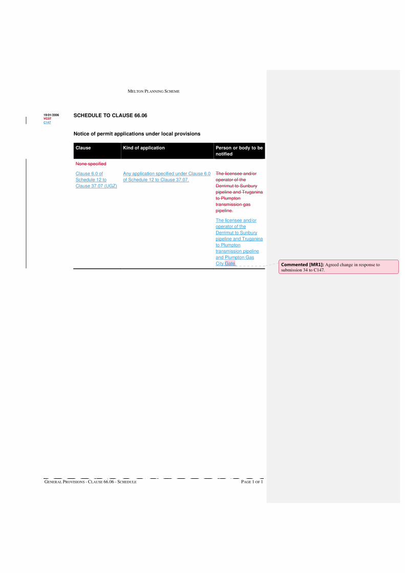
MELTON PLANNING SCHEME
GENERAL PROVISIONS - CLAUSE 66.06 - SCHEDULE PAGE 1 OF 1
SCHEDULE TO CLAUSE 66.06
Notice of permit applications under local provisions
Clause Kind of application Person or body to be
notified
None specified
Clause 6.0 of
Schedule 12 to
Clause 37.07 (UGZ)
Any application specified under Clause 6.0
of Schedule 12 to Clause 37.07.
The licensee and/or
operator of the
Derrimut to Sunbury
pipeline and Truganina
to Plumpton
transmission gas
pipeline.
The licensee and/or
operator of the
Derrimut to Sunbury
pipeline and Truganina
to Plumpton
transmission pipeline
and Plumpton Gas
City Gate.
19/01/2006 VC37
C147
Commented [MR1]: Agreed change in response to submission 34 to C147.

MELTON PLANNING SCHEME
PARTICULAR PROVISIONS – CLAUSE 52.17 - SCHEDULE PAGE 2 OF 2
2.0 Scheduled weed
Area Description of weed
None specified
3.0 Utility installation code of practice
Name of code of practice
None specified
15/09/2008 VC49
15/09/2008
VC49
MELTON PLANNING SCHEME
INCORPORATED DOCUMENTS - CLAUSE 81.01 - SCHEDULE PAGE 1 OF 2
SCHEDULE TO CAUSE 81.01
Name of document Introduced by:
Australian Standard AS2021-2015, Acoustics – Aircraft Noise Intrusion – Building Siting and Construction, Standards Australia Limited, 2015
VC107
Calder Park Train Stabling and Maintenance Yards Incorporated Document, September 2012
C125
Caroline Springs Town Centre Comprehensive Development Plan August 2000
C14
Chartwell Restructure Allotment Plan (August 1992) NPS1
Conditions for use of Lots 1&2 LP30733K, Plumpton Road for rock crushing C9
Conditions for use of south-west corner of Greigs Road and Mount Cottrell Road, Melton, Crown Portions 1 and 2, Section 11, Parish of Pywheitjorrk for Extractive Industry
C13
Design and Siting Guidelines for Rural Zones, Melton Shire Council, 1996 NPS1
Diggers Rest Development Contributions Plan, March 2012 C121
Diggers Rest Native Vegetation Precinct Plan, March 2012 C121
Diggers Rest Precinct Structure Plan, March 2012 C121
Eynesbury Station Incorporated Plan, September 2001 C20
Guidelines for the Preparation of Environmental Management Plans in Melton’s Rural Areas, Melton Shire Council, 1996
NPS1
HO110 Kerr Farm Site 1780-1882 Boundary Road, Mt Cottrell Incorporated Plan (2009)
C71
HO112 65-543 Greigs Road, Truganina Incorporated Plan (2009) C71
HO128 – Stoneleigh Homestead Complex, 196 Sinclairs Road, Rockbank - Statement of Significance, June 2016
C147
Kororoit Precinct Structure Plan, June 2016 C147
Melton Cemetery Incorporated Plan (2008) C73
Melton Dry Stone Wall Study Volume 3 – Statements of Significance, February 2016
C100
Melton North Precinct Structure Plan Development Contributions Plan, May 2010
C83
Melton North Precinct Structure Plan, May 2010 C83
Melton Tourist Precinct Local Area Development Plan – February 1998 C4
Mount Cottrell Class A Recycled Water Storage Facility, Incorporated Document, March 2015
C138
Palmers Road and Robinsons Road Upgrade (Sayers Road to Western Freeway, Truganina) Incorporated Document, July 2012
C81
Paynes Road Precinct Structure Plan, February 2016 C161
Rail Infrastructure Projects (comprising the Rail Gauge Standardisation Project, the Regional Fast Rail Project and the Fibre Optic Project), December 2002
VC17
Rail Infrastructure Projects Ballarat Rail Corridor Deviation: Fibre Optic Project, Integrated Approval Requirements (August 2003)
C40
Rail Infrastructure Projects Ballarat Rail Corridor Deviation: Regional Fast Rail Project, Integrated Approval Requirements (August 2003)
C40
12/05/2016 C100
C147
Commented [MR1]: Agreed change in response to submission 32 (Council).
MELTON PLANNING SCHEME
INCORPORATED DOCUMENTS - CLAUSE 81.01 - SCHEDULE PAGE 2 OF 2
Name of document Introduced by:
RDAV Rockbank Facility Incorporated Document, July 2013 C151
Regional Rail Link Project Section 1 Incorporated Document, March 2015 GC26
Regional Rail Link Project Section 2 Incorporated Document, March 2015 GC26
Robinsons Road Employment Area South Native Vegetation Precinct Plan, February 2011
C65
Rockbank North Development Contributions Plan, March 2012 C120
Rockbank North Native Vegetation Precinct Plan, March 2012 C120
Rockbank North Precinct Structure Plan, March 2012 C120
Shire of Melton Heritage Study Stage 2: Volume 6- Statements of Significance, March 2009
C71
Small Lot Housing Code, August 2014 GC22
Statement of Significance – 161 Bulmans Road, Melton West, May 2011 C113
Statement of Underlying Provisions - Land reserved for the Outer Metropolitan Ring and the E6 Transport Corridor, July 2010 (updated May 2012)
C128
Sunbury Electrification Project Incorporated Document February 2010 C96
Taylors Hill West Precinct Structure Plan (including the Taylors Hill West Native Vegetation Precinct Plan) May 2010 (Amended August 2011)
C115
Taylors Hill West Precinct Structure Plan, Development Contributions Plan, July 2010 (Amended October 2012)
C110
Toolern Park Precinct Structure Plan, August 2014 C122
Toolern Park Development Contributions Plan, August 2014 C122
Toolern Precinct Structure Plan (including Toolern Native Vegetation Precinct Plan), July 2011 (Amended December 2015)
C161
Toolern Development Contributions Plan, July 2011 (Amended December 2015)
C161
Water for a Growing West Project Incorporated Document, July 2014 GC18
Western Highway Realignment (Melton to Bacchus Marsh) Incorporated Document, December 2009
C94

Melton C146 & C147 | VPA submission to Planning Panels Victoria | November 2016
PART A | Summary of Submission Page 70 of 88
APPENDIX 7 Commonwealth Notice of Decision to Endorse the Program to Revise Melbourne UGB – February 2010
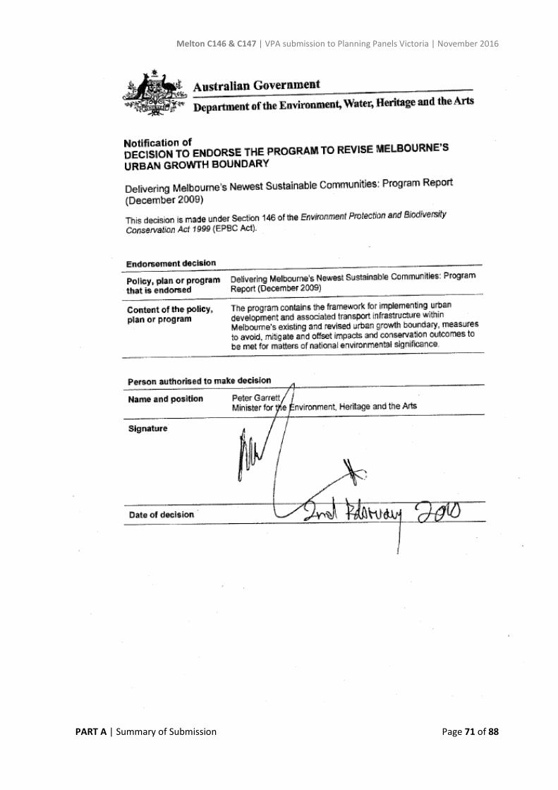
Melton C146 & C147 | VPA submission to Planning Panels Victoria | November 2016
PART A | Summary of Submission Page 71 of 88
Melton C146 & C147 | VPA submission to Planning Panels Victoria | November 2016
PART A | Summary of Submission Page 72 of 88
APPENDIX 8 Commonwealth Approval for taking actions in accordance with the endorsed EPBC Act 1999 – July 2010

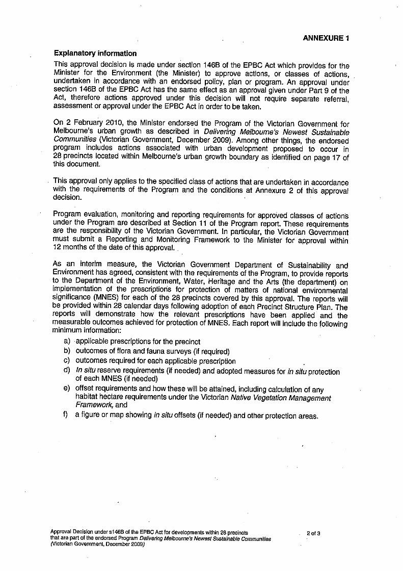
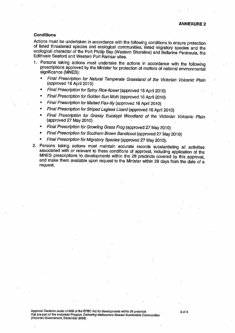
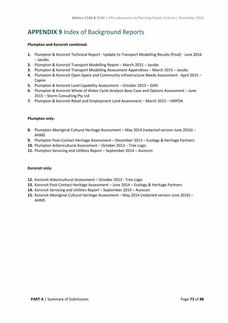
Melton C146 & C147 | VPA submission to Planning Panels Victoria | November 2016
PART A | Summary of Submission Page 73 of 88
APPENDIX 9 Index of Background Reports
Plumpton and Kororoit combined:
1. Plumpton & Kororoit Technical Report - Update to Transport Modelling Results (Final) - June 2016– Jacobs
2. Plumpton & Kororoit Transport Modelling Report – March 2015 – Jacobs3. Plumpton & Kororoit Transport Modelling Assessment Appendices – March 2015 – Jacobs4. Plumpton & Kororoit Open Space and Community Infrastructure Needs Assessment - April 2015 –
Capire5. Plumpton & Kororoit Land Capability Assessment – October 2013 – GHD6. Plumpton & Kororoit Whole of Water Cycle Analysis Base Case and Options Assessment – June
2015 – Storm Consulting Pty Ltd7. Plumpton & Kororoit Retail and Employment Land Assessment – March 2015 – HillPDA
Plumpton only:
8. Plumpton Aboriginal Cultural Heritage Assessment – May 2014 (redacted version June 2016) –AHMS
9. Plumpton Post-Contact Heritage Assessment – December 2013 – Ecology & Heritage Partners10. Plumpton Arboricultural Assessment – October 2013 – Tree Logic11. Plumpton Servicing and Utilities Report – September 2014 – Aurecon
Kororoit only:
12. Kororoit Arboricultural Assessment – October 2013 - Tree Logic13. Kororoit Post-Contact Heritage Assessment – June 2014 – Ecology & Heritage Partners14. Kororoit Servicing and Utilities Report – September 2014 – Aurecon15. Kororoit Aboriginal Cultural Heritage Assessment – May 2014 (redacted version June 2016) –
AHMS

Melton C146 & C147 | VPA submission to Planning Panels Victoria | November 2016
PART A | Summary of Submission Page 74 of 88
APPENDIX 10 Proposed revisions to applied Residential Zones (Plumpton PSP and Kororoit PSP)
1. Applied Residential Zoning
The VPA proposes to reduce the proposed extent of the applied Residential Growth Zone (RGZ) from the publicly exhibited extent, in response to Council’s submission. The General Residential Zone is proposed to be applied for the balance of the areas shown as ‘residential’ on Plan 3 in both Plumpton and Kororoit PSPs.
The VPA remains committed to using the applied RGZ across significant areas of the Plumpton and Kororoit PSPs for the following reasons:
• Enabling Increased Choice and Diversity• Facilitating the Permanent Urban Growth Boundary• Delivering the 20 Minute City• Delivering the structure for Compact and Liveable Communities
In summary, the VPA contends that the RGZ is an appropriate zone to apply for the reasons outlined above, as it provides the opportunity for greater housing diversity and employment opportunities. The RGZ allows a range of useful/desirable, small floor area, non-residential uses on land within 100 metres of town centres/commercial areas (where the land and the town centre/ commercial area share the same street frontage). The RGZ provides the right signals to the community from the outset that urban communities are dynamic and will evolve over time.
In response to Council’s submission, the VPA proposes to update the PSP by using the applied RGZ only in locations which meet strategically-justified criteria for identifying areas of higher accessibility, with good access to services, transport and infrastructure, and using the GRZ in other locations. The criteria for applying the RGZ are proposed as follows:
• 800m of the Major Town Centre (from central retail core)• 600m of the Principal Public Transport Network (from centre-line)• 400m from Local Town Centres (from boundary of LTC)• 100m from co-located, community hubs, sports reserves and LCCs
Further explanation of these distances, and their strategic justification, is outlined in Table 1. In the proposed revised plans included in this Part A submission, the VPA has applied discretion with some of these criteria to deliver a boundary to each residential zone which is manageable in practice.
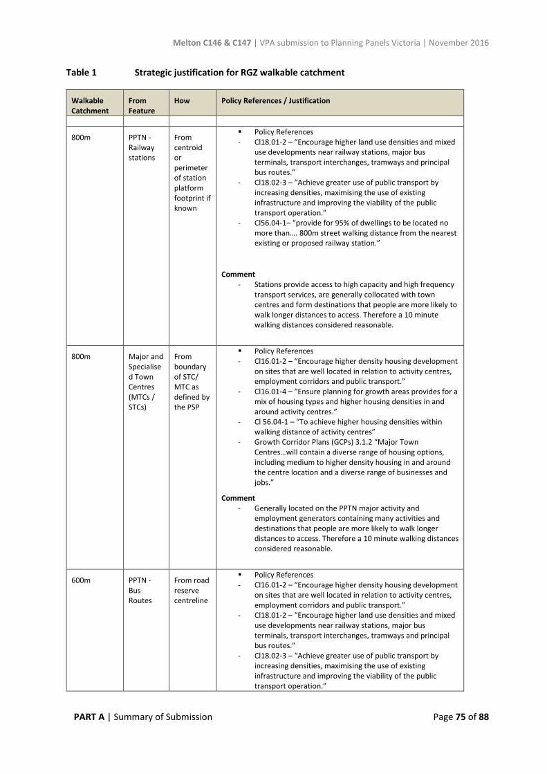
Melton C146 & C147 | VPA submission to Planning Panels Victoria | November 2016
PART A | Summary of Submission Page 75 of 88
Table 1 Strategic justification for RGZ walkable catchment
Walkable Catchment
From Feature
How Policy References / Justification
800m PPTN - Railway stations
From centroid or perimeter of station platform footprint if known
Policy References- Cl18.01-2 – “Encourage higher land use densities and mixed
use developments near railway stations, major busterminals, transport interchanges, tramways and principalbus routes.”
- Cl18.02-3 – “Achieve greater use of public transport byincreasing densities, maximising the use of existinginfrastructure and improving the viability of the publictransport operation.”
- Cl56.04-1– “provide for 95% of dwellings to be located nomore than…. 800m street walking distance from the nearest existing or proposed railway station.”
Comment - Stations provide access to high capacity and high frequency
transport services, are generally collocated with town centres and form destinations that people are more likely towalk longer distances to access. Therefore a 10 minutewalking distances considered reasonable.
800m Major and Specialised Town Centres (MTCs / STCs)
From boundary of STC/ MTC as defined by the PSP
Policy References- Cl16.01-2 – “Encourage higher density housing development
on sites that are well located in relation to activity centres,employment corridors and public transport.”
- Cl16.01-4 – “Ensure planning for growth areas provides for amix of housing types and higher housing densities in and around activity centres.”
- Cl 56.04-1 – “To achieve higher housing densities within walking distance of activity centres”
- Growth Corridor Plans (GCPs) 3.1.2 “Major TownCentres…will contain a diverse range of housing options,including medium to higher density housing in and around the centre location and a diverse range of businesses and jobs.”
Comment - Generally located on the PPTN major activity and
employment generators containing many activities and destinations that people are more likely to walk longerdistances to access. Therefore a 10 minute walking distancesconsidered reasonable.
600m PPTN - Bus Routes
From road reserve centreline
Policy References- Cl16.01-2 – “Encourage higher density housing development
on sites that are well located in relation to activity centres,employment corridors and public transport.”
- Cl18.01-2 – “Encourage higher land use densities and mixed use developments near railway stations, major busterminals, transport interchanges, tramways and principalbus routes.”
- Cl18.02-3 – “Achieve greater use of public transport byincreasing densities, maximising the use of existinginfrastructure and improving the viability of the publictransport operation.”
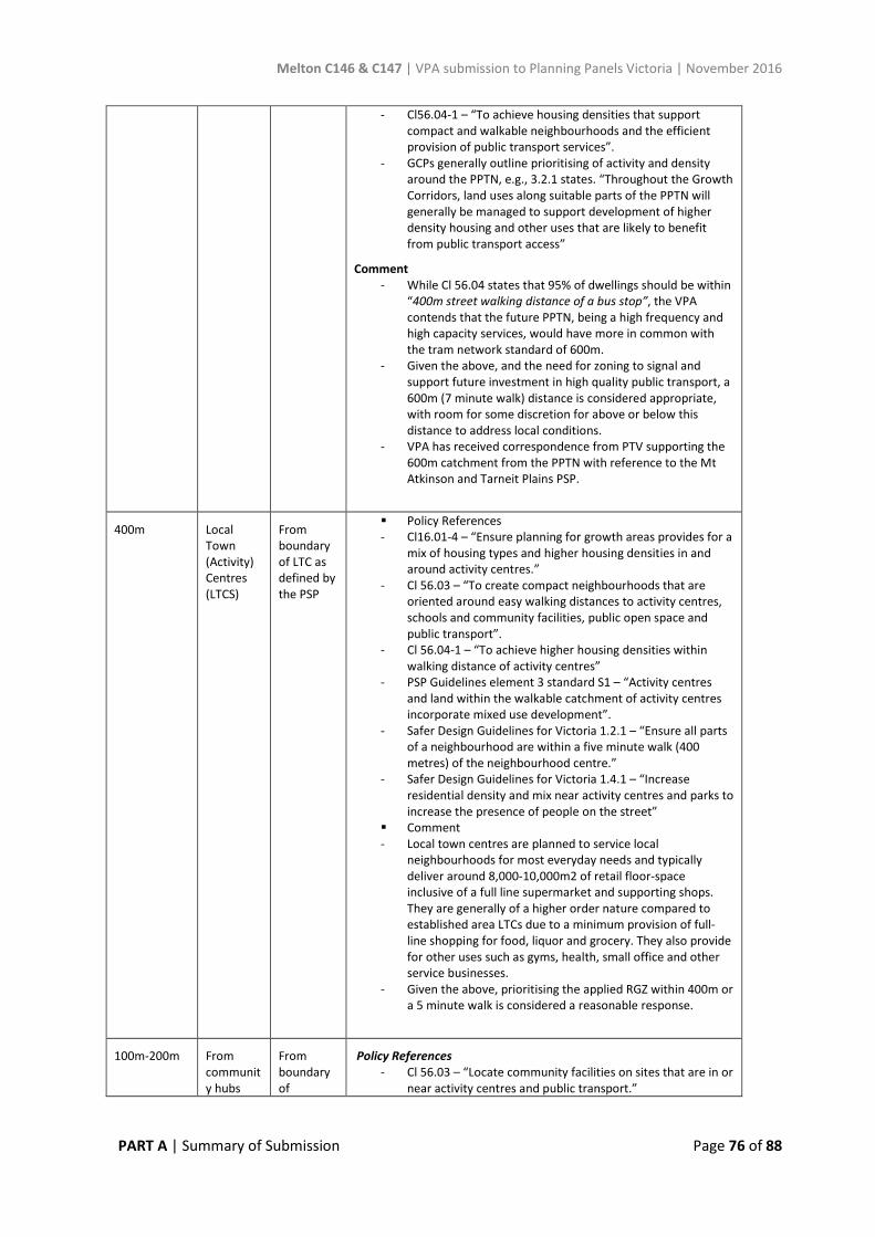
Melton C146 & C147 | VPA submission to Planning Panels Victoria | November 2016
PART A | Summary of Submission Page 76 of 88
- Cl56.04-1 – “To achieve housing densities that supportcompact and walkable neighbourhoods and the efficientprovision of public transport services”.
- GCPs generally outline prioritising of activity and densityaround the PPTN, e.g., 3.2.1 states. “Throughout the Growth Corridors, land uses along suitable parts of the PPTN willgenerally be managed to support development of higherdensity housing and other uses that are likely to benefitfrom public transport access”
Comment - While Cl 56.04 states that 95% of dwellings should be within
“400m street walking distance of a bus stop”, the VPAcontends that the future PPTN, being a high frequency and high capacity services, would have more in common with the tram network standard of 600m.
- Given the above, and the need for zoning to signal and support future investment in high quality public transport, a600m (7 minute walk) distance is considered appropriate,with room for some discretion for above or below thisdistance to address local conditions.
- VPA has received correspondence from PTV supporting the 600m catchment from the PPTN with reference to the MtAtkinson and Tarneit Plains PSP.
400m Local Town (Activity) Centres (LTCS)
From boundary of LTC as defined by the PSP
Policy References- Cl16.01-4 – “Ensure planning for growth areas provides for a
mix of housing types and higher housing densities in and around activity centres.”
- Cl 56.03 – “To create compact neighbourhoods that are oriented around easy walking distances to activity centres,schools and community facilities, public open space and public transport”.
- Cl 56.04-1 – “To achieve higher housing densities within walking distance of activity centres”
- PSP Guidelines element 3 standard S1 – “Activity centresand land within the walkable catchment of activity centresincorporate mixed use development”.
- Safer Design Guidelines for Victoria 1.2.1 – “Ensure all partsof a neighbourhood are within a five minute walk (400metres) of the neighbourhood centre.”
- Safer Design Guidelines for Victoria 1.4.1 – “Increase residential density and mix near activity centres and parks toincrease the presence of people on the street”
Comment- Local town centres are planned to service local
neighbourhoods for most everyday needs and typicallydeliver around 8,000-10,000m2 of retail floor-space inclusive of a full line supermarket and supporting shops.They are generally of a higher order nature compared toestablished area LTCs due to a minimum provision of full-line shopping for food, liquor and grocery. They also provide for other uses such as gyms, health, small office and otherservice businesses.
- Given the above, prioritising the applied RGZ within 400m ora 5 minute walk is considered a reasonable response.
100m-200m From community hubs
From boundary of
Policy References - Cl 56.03 – “Locate community facilities on sites that are in or
near activity centres and public transport.”
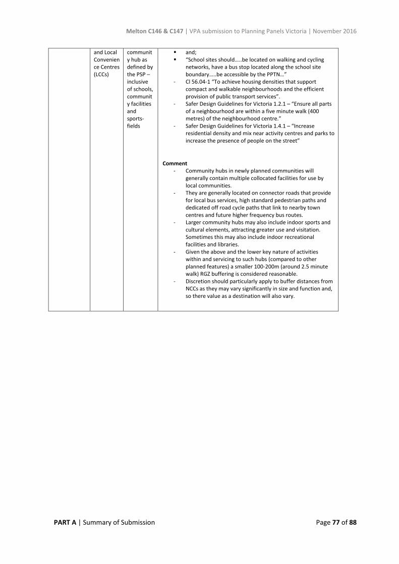
Melton C146 & C147 | VPA submission to Planning Panels Victoria | November 2016
PART A | Summary of Submission Page 77 of 88
and Local Convenience Centres (LCCs)
community hub as defined by the PSP – inclusive of schools, community facilities and sports-fields
and; “School sites should…..be located on walking and cycling
networks, have a bus stop located along the school site boundary…..be accessible by the PPTN…”
- Cl 56.04-1 “To achieve housing densities that supportcompact and walkable neighbourhoods and the efficientprovision of public transport services”.
- Safer Design Guidelines for Victoria 1.2.1 – “Ensure all partsof a neighbourhood are within a five minute walk (400metres) of the neighbourhood centre.”
- Safer Design Guidelines for Victoria 1.4.1 – “Increase residential density and mix near activity centres and parks toincrease the presence of people on the street”
Comment - Community hubs in newly planned communities will
generally contain multiple collocated facilities for use bylocal communities.
- They are generally located on connector roads that providefor local bus services, high standard pedestrian paths and dedicated off road cycle paths that link to nearby town centres and future higher frequency bus routes.
- Larger community hubs may also include indoor sports and cultural elements, attracting greater use and visitation.Sometimes this may also include indoor recreationalfacilities and libraries.
- Given the above and the lower key nature of activitieswithin and servicing to such hubs (compared to otherplanned features) a smaller 100-200m (around 2.5 minute walk) RGZ buffering is considered reasonable.
- Discretion should particularly apply to buffer distances fromNCCs as they may vary significantly in size and function and,so there value as a destination will also vary.
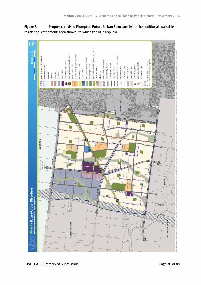
Melton C146 & C147 | VPA submission to Planning Panels Victoria | November 2016
PART A | Summary of Submission Page 78 of 88
Figure 5 Proposed revised Plumpton Future Urban Structure (with the additional ‘walkable residential catchment’ area shown, to which the RGZ applies)
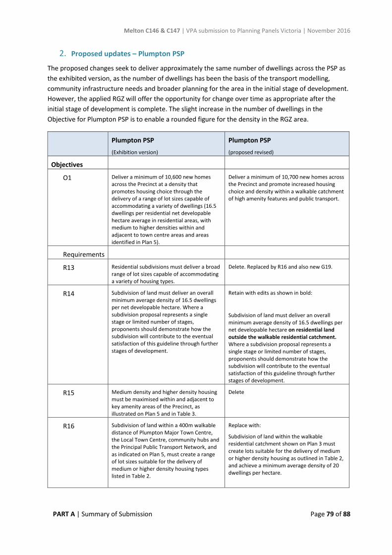
Melton C146 & C147 | VPA submission to Planning Panels Victoria | November 2016
PART A | Summary of Submission Page 79 of 88
2. Proposed updates – Plumpton PSP
The proposed changes seek to deliver approximately the same number of dwellings across the PSP as the exhibited version, as the number of dwellings has been the basis of the transport modelling, community infrastructure needs and broader planning for the area in the initial stage of development. However, the applied RGZ will offer the opportunity for change over time as appropriate after the initial stage of development is complete. The slight increase in the number of dwellings in the Objective for Plumpton PSP is to enable a rounded figure for the density in the RGZ area.
Plumpton PSP
(Exhibition version)
Plumpton PSP
(proposed revised)
Objectives
O1 Deliver a minimum of 10,600 new homes across the Precinct at a density that promotes housing choice through the delivery of a range of lot sizes capable of accommodating a variety of dwellings (16.5 dwellings per residential net developable hectare average in residential areas, with medium to higher densities within and adjacent to town centre areas and areas identified in Plan 5).
Deliver a minimum of 10,700 new homes across the Precinct and promote increased housing choice and density within a walkable catchment of high amenity features and public transport.
Requirements
R13 Residential subdivisions must deliver a broad range of lot sizes capable of accommodating a variety of housing types.
Delete. Replaced by R16 and also new G19.
R14 Subdivision of land must deliver an overall minimum average density of 16.5 dwellings per net developable hectare. Where a subdivision proposal represents a single stage or limited number of stages, proponents should demonstrate how the subdivision will contribute to the eventual satisfaction of this guideline through further stages of development.
Retain with edits as shown in bold:
Subdivision of land must deliver an overall minimum average density of 16.5 dwellings per net developable hectare on residential land outside the walkable residential catchment. Where a subdivision proposal represents a single stage or limited number of stages, proponents should demonstrate how the subdivision will contribute to the eventual satisfaction of this guideline through further stages of development.
R15 Medium density and higher density housing must be maximised within and adjacent to key amenity areas of the Precinct, as illustrated on Plan 5 and in Table 3.
Delete
R16 Subdivision of land within a 400m walkable distance of Plumpton Major Town Centre, the Local Town Centre, community hubs and the Principal Public Transport Network, and as indicated on Plan 5, must create a range of lot sizes suitable for the delivery of medium or higher density housing types listed in Table 2.
Replace with:
Subdivision of land within the walkable residential catchment shown on Plan 3 must create lots suitable for the delivery of medium or higher density housing as outlined in Table 2, and achieve a minimum average density of 20 dwellings per hectare.
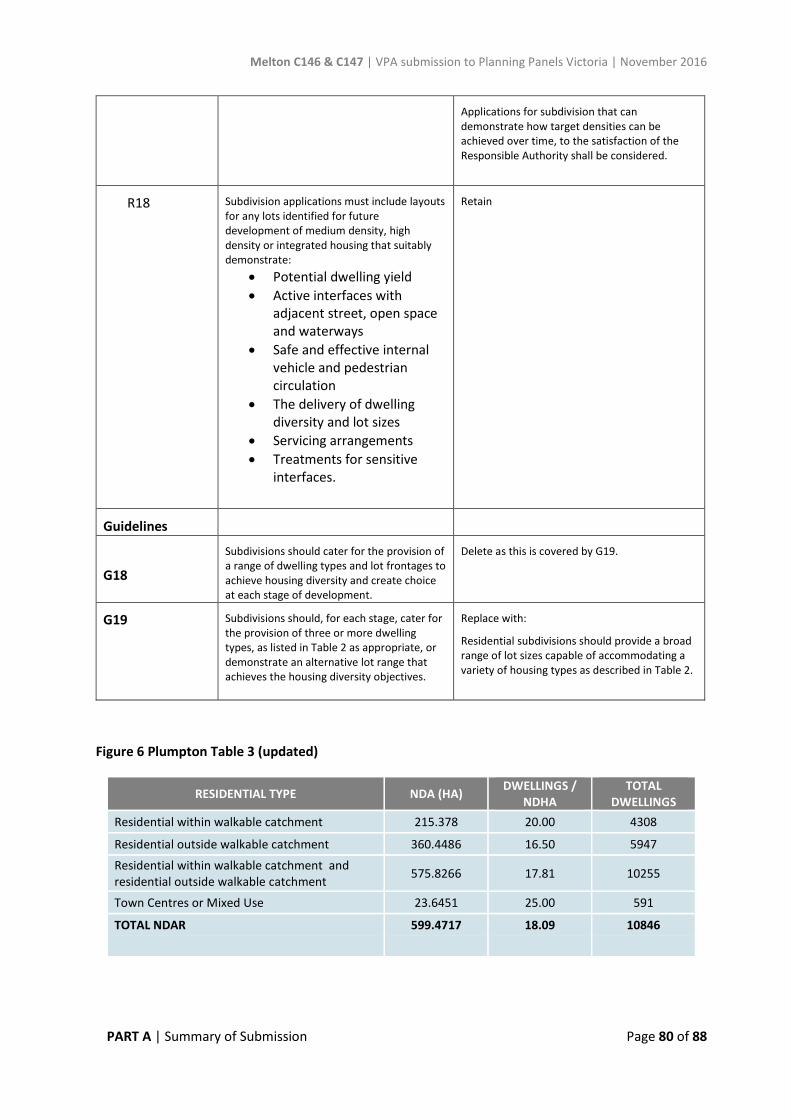
Melton C146 & C147 | VPA submission to Planning Panels Victoria | November 2016
PART A | Summary of Submission Page 80 of 88
Applications for subdivision that can demonstrate how target densities can be achieved over time, to the satisfaction of the Responsible Authority shall be considered.
R18 Subdivision applications must include layouts for any lots identified for future development of medium density, high density or integrated housing that suitably demonstrate:
• Potential dwelling yield• Active interfaces with
adjacent street, open spaceand waterways
• Safe and effective internalvehicle and pedestriancirculation
• The delivery of dwellingdiversity and lot sizes
• Servicing arrangements• Treatments for sensitive
interfaces.
Retain
Guidelines
G18
Subdivisions should cater for the provision of a range of dwelling types and lot frontages to achieve housing diversity and create choice at each stage of development.
Delete as this is covered by G19.
G19 Subdivisions should, for each stage, cater for the provision of three or more dwelling types, as listed in Table 2 as appropriate, or demonstrate an alternative lot range that achieves the housing diversity objectives.
Replace with:
Residential subdivisions should provide a broad range of lot sizes capable of accommodating a variety of housing types as described in Table 2.
Figure 6 Plumpton Table 3 (updated)
RESIDENTIAL TYPE NDA (HA) DWELLINGS / NDHA
TOTAL DWELLINGS
Residential within walkable catchment 215.378 20.00 4308
Residential outside walkable catchment 360.4486 16.50 5947
Residential within walkable catchment and residential outside walkable catchment 575.8266 17.81 10255
Town Centres or Mixed Use 23.6451 25.00 591
TOTAL NDAR 599.4717 18.09 10846
Melton C146 & C147 | VPA submission to Planning Panels Victoria | November 2016
PART A | Summary of Submission Page 81 of 88
3. Proposed Updates – Kororoit PSP
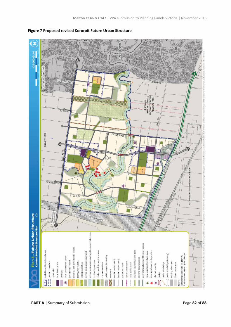
Melton C146 & C147 | VPA submission to Planning Panels Victoria | November 2016
PART A | Summary of Submission Page 82 of 88
Figure 7 Proposed revised Kororoit Future Urban Structure
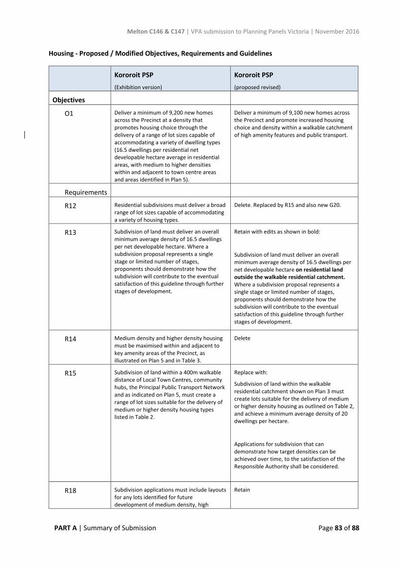
Melton C146 & C147 | VPA submission to Planning Panels Victoria | November 2016
PART A | Summary of Submission Page 83 of 88
Housing - Proposed / Modified Objectives, Requirements and Guidelines
Kororoit PSP
(Exhibition version)
Kororoit PSP
(proposed revised)
Objectives
O1 Deliver a minimum of 9,200 new homes across the Precinct at a density that promotes housing choice through the delivery of a range of lot sizes capable of accommodating a variety of dwelling types (16.5 dwellings per residential net developable hectare average in residential areas, with medium to higher densities within and adjacent to town centre areas and areas identified in Plan 5).
Deliver a minimum of 9,100 new homes across the Precinct and promote increased housing choice and density within a walkable catchment of high amenity features and public transport.
Requirements
R12 Residential subdivisions must deliver a broad range of lot sizes capable of accommodating a variety of housing types.
Delete. Replaced by R15 and also new G20.
R13 Subdivision of land must deliver an overall minimum average density of 16.5 dwellings per net developable hectare. Where a subdivision proposal represents a single stage or limited number of stages, proponents should demonstrate how the subdivision will contribute to the eventual satisfaction of this guideline through further stages of development.
Retain with edits as shown in bold:
Subdivision of land must deliver an overall minimum average density of 16.5 dwellings per net developable hectare on residential land outside the walkable residential catchment. Where a subdivision proposal represents a single stage or limited number of stages, proponents should demonstrate how the subdivision will contribute to the eventual satisfaction of this guideline through further stages of development.
R14 Medium density and higher density housing must be maximised within and adjacent to key amenity areas of the Precinct, as illustrated on Plan 5 and in Table 3.
Delete
R15 Subdivision of land within a 400m walkable distance of Local Town Centres, community hubs, the Principal Public Transport Network and as indicated on Plan 5, must create a range of lot sizes suitable for the delivery of medium or higher density housing types listed in Table 2.
Replace with:
Subdivision of land within the walkable residential catchment shown on Plan 3 must create lots suitable for the delivery of medium or higher density housing as outlined on Table 2, and achieve a minimum average density of 20 dwellings per hectare.
Applications for subdivision that can demonstrate how target densities can be achieved over time, to the satisfaction of the Responsible Authority shall be considered.
R18 Subdivision applications must include layouts for any lots identified for future development of medium density, high
Retain
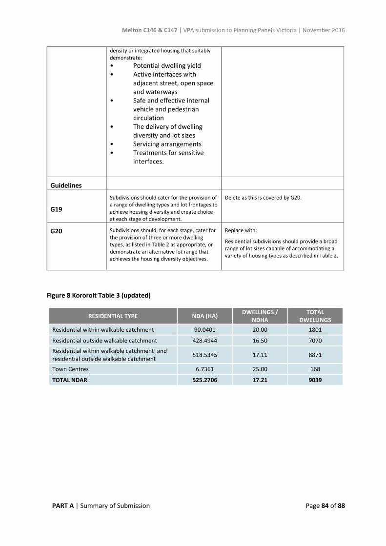
Melton C146 & C147 | VPA submission to Planning Panels Victoria | November 2016
PART A | Summary of Submission Page 84 of 88
density or integrated housing that suitably demonstrate: • Potential dwelling yield• Active interfaces with
adjacent street, open spaceand waterways
• Safe and effective internalvehicle and pedestriancirculation
• The delivery of dwellingdiversity and lot sizes
• Servicing arrangements• Treatments for sensitive
interfaces.
Guidelines
G19
Subdivisions should cater for the provision of a range of dwelling types and lot frontages to achieve housing diversity and create choice at each stage of development.
Delete as this is covered by G20.
G20 Subdivisions should, for each stage, cater for the provision of three or more dwelling types, as listed in Table 2 as appropriate, or demonstrate an alternative lot range that achieves the housing diversity objectives.
Replace with:
Residential subdivisions should provide a broad range of lot sizes capable of accommodating a variety of housing types as described in Table 2.
Figure 8 Kororoit Table 3 (updated)
RESIDENTIAL TYPE NDA (HA) DWELLINGS / NDHA
TOTAL DWELLINGS
Residential within walkable catchment 90.0401 20.00 1801
Residential outside walkable catchment 428.4944 16.50 7070
Residential within walkable catchment and residential outside walkable catchment 518.5345 17.11 8871
Town Centres 6.7361 25.00 168
TOTAL NDAR 525.2706 17.21 9039
Melton C146 & C147 | VPA submission to Planning Panels Victoria | November 2016
PART A | Summary of Submission Page 85 of 88
APPENDIX 11 Proposed revisions to Dry Stone Wall approach (Plumpton PSP and Kororoit PSP)
Following a large number of submissions related to the requirement to retain dry stone walls, including how it would work in practice, the VPA, in consultation with Council and submitters, proposes the following modifications to the PSPs:
• Update Requirement (R6 Kororoit and R8 Plumpton) to start with the word ‘significant’, asfollows:
• “Significant dry stone walls….” • Insert a new Guideline in 3.1.2 Heritage in both Kororoit and Plumpton PSPs, with the same
wording as R6 Kororoit and R8 Plumpton, but replacing the word ‘must’, with the word ‘should’.• Update Plan 2 in each PSP to categorise dry stone walls as either ‘significant’ or ‘other’. These
designations are based on the advice contained in the VPA’s Plumpton Post-Contact HeritageAssessment – December 2013 – Ecology & Heritage Partners and Kororoit Post-Contact HeritageAssessment – June 2014 – Ecology & Heritage Partners. Walls classified of ‘low’ significance orabove, or which were part of a heritage overlay, were considered ‘significant’.
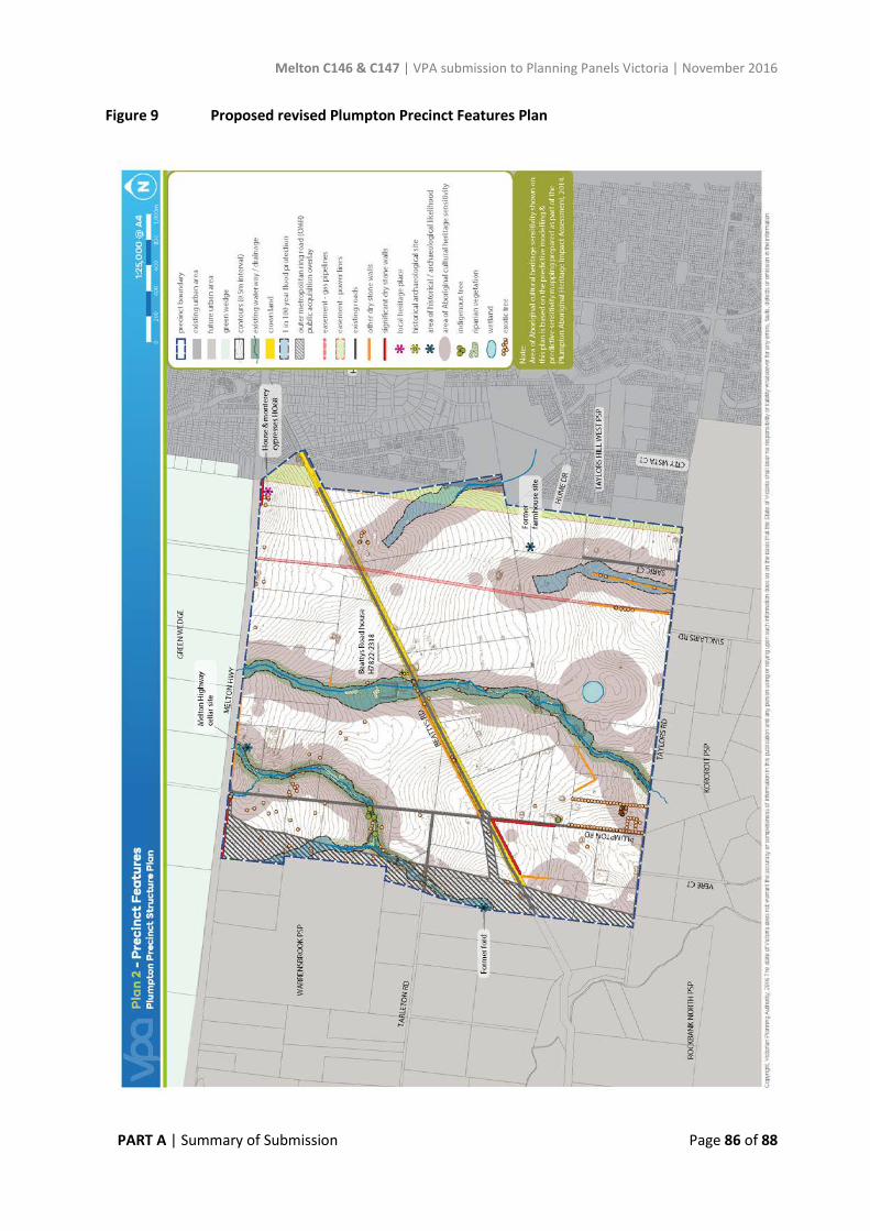
Melton C146 & C147 | VPA submission to Planning Panels Victoria | November 2016
PART A | Summary of Submission Page 86 of 88
Figure 9 Proposed revised Plumpton Precinct Features Plan

Melton C146 & C147 | VPA submission to Planning Panels Victoria | November 2016
PART A | Summary of Submission Page 87 of 88
Figure 10 Proposed revised Kororoit Precinct Features Plan

Melton C146 & C147 | VPA submission to Planning Panels Victoria | November 2016
PART A | Summary of Submission Page 88 of 88
APPENDIX 12 Proposed new Guidelines for minimising crossover in the short term to Plumpton Rd (Plumpton PSP) and Sinclairs Rd (Kororoit PSP)
VPA proposes a new Guideline in response to Council concerns regarding the role of the existing Sinclairs and Plumpton Roads until the relevant sections of the future Hopkins Road arterial have been built. Once Hopkins Road is built (one lane in each direction) this will reduce traffic volumes on Sinclairs and Plumpton Roads.
The proposed new Guideline is to the satisfaction of a number of affected submitters, with one submitter still considering the matter. Council has not agreed that the Guideline is sufficient.
Proposed wording of the new Guideline in 3.5.1 Street network is as follows:
Plumpton PSP
"Minimise the number of new crossovers to Plumpton Road (between Taylors and Tarleton Roads) until the first carriageway for the Hopkins Road alignment (between Taylors and Tarleton Roads) and the first carriageway of Tarleton Road (between Hopkins and Plumpton Roads) are constructed, to the satisfaction of the responsible authority".
Kororoit PSP
“Minimise the number of new crossovers to Sinclairs Road north of Neale Road until the first carriageway for the Hopkins Road alignment is constructed between Neale Road and Taylors Road, to the satisfaction of the responsible authority.”

Plumpton PSP & Kororoit PSP - Amendment to the Melton Planning Scheme - November 2016