prudhoe bay causeways and the summer coastal …pubs.aina.ucalgary.ca/arctic/arctic52-2-139.pdf ·...
TRANSCRIPT

ARCTIC
VOL. 52, NO. 2 (JUNE 1999) P. 139– 151
Prudhoe Bay Causeways and the Summer Coastal Movementsof Arctic Cisco and Least Cisco
ROBERT G. FECHHELM,1 LARRY R. MARTIN,1 BENNY J. GALLAWAY,1 WILLIAM J. WILSON2
and WILLIAM B. GRIFFITHS3
(Received 5 December 1997; accepted in revised form 15 October 1998)
ABSTRACT. Catch-per-unit-effort and mark-recapture data collected by fyke net during the summers of 1985–93 near PrudhoeBay, Alaska, were analyzed to determine whether two oil industry causeways constructed perpendicular to the Beaufort Sea coast,West Dock and the Endicott Causeway, affected the feeding and migratory patterns of least cisco (Coregonus sardinella) and arcticcisco (C. autumnalis). During two of the four years in which juvenile least cisco were abundant in the study area, catch rates weresignificantly lower (p ≤ 0.0005) east of West Dock, which suggested that small fish traveling eastward along the coast failed tobypass the causeway. Hydrographic conditions were generally consistent with the hypothesis that causeway-induced upwellingsof saline marine water immediately west of West Dock may affect alongshore movement. No such disparities in catch wereobserved at the Endicott Causeway. We studied rates of return for subadult and adult (≥ 250 mm) arctic cisco and least cisco taggedin the Prudhoe Bay area and recovered in a commercial fishery that operates in the Colville River, Alaska. The expected rate ofreturn was compared with actual rates of return over five years (for least cisco) and six years (for arctic cisco). Rates of return werebased upon three areas of release: east of the easternmost causeway, west of the westernmost causeway, and between the twocauseways. For both species, across the three regions and all years, there was no significant difference (p = 0.25 for least cisco;p = 0.30 for arctic cisco) between the expected and actual rates of tag returns. The contrasting effects of the two causeways arediscussed in terms of their design and location.
Key words: Coregonus sardinella, least cisco, Coregonus autumnalis, arctic cisco, Beaufort Sea, causeways, Arctic oil, impacts
RÉSUMÉ. Les données de prises par unité d’effort et de marquage-recapture, recueillies par des verveux au cours des étés de 1985à 1993 près de Prudhoe Bay en Alaska, ont été analysées afin de déterminer si deux ponts-jetées construits pour l’industriepétrolière perpendiculairement au rivage de la mer de Beaufort (le pont-jetée West Dock et le pont-jetée Endicott) affectaient lesschémas de nutrition et de migration du cisco sardinelle (Coregonus sardinella) et du cisco arctique (C. autumnalis). Durant deuxdes quatre années au cours desquelles le cisco sardinelle juvénile était abondant dans la zone de l’étude, les taux de prises étaientsensiblement inférieurs (p ≤ 0,0005) à l’est du West Dock, ce qui suggérait que les poissons de petite taille se dirigeant vers l’estle long de la côte ne réussissaient pas à contourner le pont-jetée. En général, les conditions hydrographiques concordaient avecl’hypothèse que les remontées d’eau marine salée provoquées par le pont-jetée juste à l’ouest du West Dock peuvent affecter lemouvement le long du rivage. On n’a observé aucun écart de ce genre dans les prises au pont-jetée Endicott. On a étudié les tauxde retour pour les jeunes adultes et les adultes (≥ 250 mm) du cisco arctique et du cisco sardinelle, marqués dans la région de labaie de Prudhoe et recapturés dans une pêcherie commerciale en exploitation sur la rivière Colville en Alaska. On a comparé letaux de retour escompté aux taux de retour réels sur cinq ans (pour le cisco sardinelle) et sur six ans (pour le cisco arctique). Lestaux de retour s’appuyaient sur trois zones de remise à l’eau: à l’est du pont-jetée le plus oriental, à l’ouest du plus occidental etentre les deux. En tenant compte des trois emplacements et de toutes les années, il n’y avait pas de différence marquante pourles deux espèces (p = 0,25 pour le cisco sardinelle; p = 0,30 pour le cisco arctique) entre les taux de retour prévus et les taux réelsdes individus marqués. On discute les effets opposés des deux ponts-jetées en considérant leur design et leur emplacement.
Mots clés: Coregonus sardinella, cisco sardinelle, Coregonus autumnalis, cisco arctique, mer de Beaufort, ponts-jetées, pétrolearctique, retombées
Traduit pour la revue Arctic par Nésida Loyer.
1 LGL Ecological Research Associates, Inc., 1410 Cavitt Street, Bryan, Texas 77801, U.S.A.2 LGL Alaska Research Associates, Inc., 4175 Tudor Centre Drive, Anchorage, Alaska 99508, U.S.A.3 LGL Environmental Research Associates, Inc., 9768 Second Street, Sidney, British Columbia V8L 3Y8, Canada
© The Arctic Institute of North America
INTRODUCTION
Since the late 1970s, summer fish surveys have beenconducted regularly in the coastal waters of the Beaufort
Sea near Prudhoe Bay, Alaska, to monitor the effects oflocal oil and gas development on regional fishery re-sources (e.g., Craig and Haldorson, 1981; Griffiths andGallaway, 1982; Moulton et al., 1986; Cannon et al., 1987;

140 • R.G. FECHHELM et al.
Glass et al., 1990; Reub et al., 1991; LGL, 1992; Griffithset al., 1996). Development has included the constructionof solid-fill, breached, gravel causeways that extend sea-ward from the coast. These structures are used as platformsin recovering offshore petroleum reserves and extractingseawater that is injected into subsurface oil reservoirs. Aprimary concern has been whether these causeways ad-versely affect summer coastal feeding dispersals and mi-grations of diadromous species that are important tocommercial and Native subsistence fisheries (U.S. ArmyCorps of Engineers, 1980, 1984).
Two fish species that have been studied extensivelyover the years are least cisco (Coregonus sardinella) andarctic cisco (C. autumnalis). Least cisco spawn andoverwinter in the Colville River, located approximately 90km west of Prudhoe Bay, but are not normally found in anyAlaskan river to the east (Craig, 1984, 1989). The nearestpopulation is 600 km away in the Mackenzie River, Canada.Arctic cisco found in the Alaskan Beaufort Sea are be-lieved to originate from spawning grounds in the Macken-zie River system (Gallaway et al., 1983). In spring, newlyhatched young-of-the-year are flushed downriver, andsome are transported westward to Alaska by wind-drivencoastal currents (Gallaway et al., 1983; Fechhelm andFissel, 1988, Moulton, 1989; Fechhelm and Griffiths,1990; Schmidt et al., 1991; Underwood et al., 1995;Colonell and Gallaway, 1997). In summers with strongand persistent east winds, enhanced westward transportcan carry fish to Alaska’s Colville River, where they takeup winter residence. They remain in the Colville Riveruntil the onset of sexual maturity at about age seven; thenthey migrate back to the Mackenzie River to spawn(Gallaway et al., 1983). The Colville River appears to bethe only Alaskan river large enough to support substantialnumbers of subadult and adult fish (Schmidt et al., 1989).
During the ice-free summer, arctic and least cisco dis-perse out of the Colville River to forage in coastal waters.Some fish move eastward through Simpson Lagoon to thePrudhoe Bay/Sagavanirktok Delta area and beyond (Can-non et al., 1987; Fechhelm et al., 1989, 1994; Glass et al.,1990; Reub et al., 1991; LGL, 1992). Summer is theprimary feeding and growth period for most fishes ofnorthern Alaska (Craig, 1989). Fish eventually migrateback to overwintering grounds in the Colville River beforethe onset of freeze-up. The exceptions are arctic cisco thathave reached reproductive maturity and return to Canadato spawn.
This paper analyzes the possible effects that PrudhoeBay causeways have on the alongshore dispersal of leastcisco and arctic cisco from their overwintering grounds inthe Colville River. Part 1 analyzes catch data for juvenileleast cisco collected during the summers from 1985 to1993. On the basis of studies conducted from 1981 to 1984,it has been suggested that West Dock, a 4.3 km longcauseway built at the western margin of Prudhoe Bay, maydisrupt the west-to-east alongshore movements of juvenileleast cisco (Fechhelm et al., 1989). East winds cause an
eddy to form on the western (lee) side of the causeway,enhancing the vertical mixing of cold, saline marine waterinto an otherwise brackish nearshore zone (Mangarella etal., 1982; Savoie and Wilson, 1983, 1986; Niedoroda andColonell, 1990). Because juvenile fish are (presumably)intolerant of high-salinity water, the cell of marine watermay occasionally block their eastward dispersal. Thispotential for blockage is assessed through the expandeddatabase.
Part 2 of this paper uses data from several mark-recapture studies to analyze rates of tag recovery in aColville River commercial gill net fishery for subadult andadult least and arctic cisco. Substantial numbers of fish≥ 250 mm tagged as part of the Prudhoe Bay monitoringstudies are recaptured in October and November in acommercial gill net fishery operated in the lower ColvilleDelta (Moulton and Field, 1994; Moulton, 1995). Thiscommercial fishery produces annual harvests ranging from9000 to 70 000 arctic cisco and from 6000 to 38 000 leastcisco, depending on the year (Moulton, 1995). Our analy-sis compares expected and observed rates of tag returns inthe commercial fishery for both species to determinewhether the two major Prudhoe Bay causeways, eithersingly or jointly, appear to affect the late-summer returnmigration of fish to the Colville River.
STUDY AREA
The study area covers 120 km of coastline running fromthe Colville River eastward through Prudhoe Bay to thedelta of the Sagavanirktok River (Fig. 1). Much of thecoastline between the Colville River and Prudhoe Bay isbounded by a chain of barrier islands, which enclosesSimpson Lagoon. West Dock is located at the eastern endof Simpson Lagoon and the western edge of Prudhoe Bay.Approximately 4.3 km long, it was constructed with abreach 15 m wide located 2.8 km offshore. Although thebreach was built as a passageway for fish moving along thecoast, virtually everyone that has studied the dynamics ofthe causeway has agreed that few fish actually use thebreach because of its small size and its location (Fechhelmet al., 1989). In recent years the breach has silted in, and noattempt has been made to dredge it open. In the winter of1995 – 96, another breach 200 m wide was constructed atthe base of West Dock, where water depths are generallyless than 2.5 m.
The Sagavanirktok Delta is located immediately east ofPrudhoe Bay, approximately 12 km east of West Dock. Itis fronted by a shallow shelf (≤ 1.5 m deep) approximately16 km wide that extends seaward for 3 – 4 km. The EndicottCauseway was constructed in the middle of the delta shelfduring the winter of 1984 – 85. The mainland segment ofthe causeway was built with a nearshore breach 152 mwide and an offshore breach 61 m wide; both were designedto serve as fish passageways and to maintain hydrographiccontinuity between the two sides of the delta.

PRUDHOE BAY CAUSEWAYS AND MOVEMENT OF CISCO • 141
FIG. 1. The Prudhoe Bay region of the Alaskan Beaufort Sea. Fyke net sampling locations are indicated by hollow and solid circles. Solid circles denoted by stationnumber are discussed in detail within the text. Station 290 (diamond) is a hydrographic station. The inset shows the location of the Colville River commercial fishery.
MATERIAL AND METHODS
Fish were collected in fyke nets located in the vicin-ity of Prudhoe Bay and the Sagavanirktok River deltaduring the summers of 1985 – 93 (Fig. 1). Although notall sites were sampled each year, net arrays did extendalong the coast from Station 223 in the west to Station204 in the east in all years, thereby providing reason-able geographical cross-sections of the study area.Surveys were conducted during the open-water season,which typically lasted from late June to late August-mid September. Except during periods of inclementweather, sampling continued 24 hours a day throughoutthe summer, and nets were emptied at approximatelythe same time each day. Captured fish were placed infloating holding pens, anaesthetized in a dilute solutionof tricaine (MS-222), measured (fork length in mm, orFL), and then released after the effects of the anaes-thetic had worn off. During the summers of 1985, 1988(arctic cisco only), and 1990 – 93, large (≥250 mm)least cisco and arctic cisco were marked prior to re-lease. We used coded anchor tags, which were insertedinto the epaxial muscle mass lateral to the posterior marginof the dorsal fin. Each code was unique, so that the releasedate and location were documented for every fish.
Juvenile Least Cisco
Catch data for juvenile least cisco were designated ascatch-per-unit-effort (CPUE). CPUE = fish·net-1·24 h-1, orthe number of fish caught per fyke net per 24 h of fishingeffort. Least cisco have historically been segregated intotwo size cohorts: small ≤180 mm FL) and large (>180 mmFL) (Griffiths et al., 1996). This delineation is based on theage structure of the population: the smaller size cohortgenerally comprises fish age three and younger. Thisportion of the paper adheres to the same cohort designa-tions and deals exclusively with fish < 180 mm in length(i.e., juveniles). The t-test (Ostle and Mensing, 1975), appliedto loge-t ransformed catch data (i.e., loge [CPUE + 1]), wasused for comparing catch among groups of nets.
Mark-Recapture Studies
Analytical methods employed in this paper were origi-nally used in a single-year study by Craig and Griffiths(1981) to assess fish movement around an early and shorterconfiguration of West Dock. For our analyses, the summerfyke net study area was divided into three regions. RegionW (west) consisted of all nets located west of West Dock;Region M (middle) comprised all nets located between

142 • R.G. FECHHELM et al.
West Dock and the Endicott causeway; and Region E(east) included all net sites east of Endicott (see Fig. 1).Because none of the Alaskan rivers that lie to the east of theColville River are known to support substantialoverwintering populations of large fish (≥ 250 mm) ofeither species (Craig, 1984), the operating premise is thatmost of the arctic and least ciscoes found in the PrudhoeBay area originate from and return to the Colville Riversystem.
For each species, the expected number of tag returns inthe commercial fishery was calculated as
Eij = (Mij/MTj) * RTj
where Eij is the expected number of tag returns in thecommercial fishery for fish released in region i in year j,Mij is the number of fish tagged in region i in year j, MTj isthe total number of fish tagged from all regions in year j,and RTj is the total number of tagged fish recaptured in thecommercial fishery in year j.
Before calculating the expected number of tag returns,we adjusted recapture data to correct for the size selectiv-ity of the commercial gill nets (76 mm stretched mesh),using the methods described by Ricker (1975). Length-frequency distributions (in 10 mm intervals) were calcu-lated for all fish of a species taken in the fishery in anygiven year. That distribution was then compared to thelength-frequency distributions of all fish tagged in eachregion that same year (Fig. 2). For each size interval, thedifference in percent composition was calculated in caseswhere fyke net frequency exceeded gill net frequency.These values were then summed across all size intervals toyield the adjustment factor. The number of tagged fish wasthen reduced by this factor to yield the effective numbertagged (i.e., the number susceptible to recapture).
The chi-square (χ2) test statistic (Ostle and Mensing,1975) was used to calculate the goodness-of-fit between thepredicted and observed number of recaptures in the commer-cial fishery for each species over all regions and years:
FIG. 2. Length-frequency distributions of least cisco tagged in Prudhoe Bayfyke nets (Region E) compared to those of all least cisco taken in the ColvilleRiver commercial gill net fishery for 1993. Shaded area represents the taggedfish that were deemed not susceptible to the size-selective gill net fishery.Similar adjustments were made for all year-region-species combinations.
FIG. 3. Seasonal catch-per-unit-effort (CPUE: fish·net-1·24 h-1) of small (<180mm) least cisco for 1985 – 93.
χ2 = SiSj((Oij - Eij)/Eij)
where Oij is the number of observed recaptures from region
i in year j and Eij is the expected number of recaptures fromregion i in year j. The underlying assumption is that withina given year, and assuming no causeway effect, all fishreleased at Prudhoe Bay have an equal probability of beingrecaptured in the commercial fishery. Fish from a particu-lar region should comprise the same proportion of recap-tures as they did of releases for that year: e.g., if during1985 least cisco from Region E comprised 31% of allreleases, they should also comprise 31% of all recapturesin the fishery that same year.
RESULTS AND DISCUSSIO
Juvenile Least Cisco
Over the nine-year study, yearly variation in the sum-mer catch rates of small least cisco was considerable (Fig.3). During the summers of 1985 – 87 and 1992 – 93, CPUEwas nominal, ranging from 0.3 to 2.2 fish·net-1·24 h-1.These catch rates contrasted sharply with those recordedduring the summers of 1988 – 91, when CPUE ranged from8.8 to 41.5 fish·net-1·24 h-1. This inter-year pattern appearsto be linked to wind-governed transport processes withinSimpson Lagoon (Fechhelm et al., 1994). West winds inearly summer (primarily July) create easterly flowingcurrents within the lagoon, and this flow enhances theeastward dispersal of small least cisco into the PrudhoeBay area. Few small least cisco reach the eastern end ofSimpson Lagoon in summers devoid of strong west windevents. The yearly catch patterns depicted in Figure 3 areconsistent with regional wind patterns over the nine-yearperiod of record (Fechhelm et al., 1994). However, the

PRUDHOE BAY CAUSEWAYS AND MOVEMENT OF CISCO • 143
FIG. 4. Catch-per-unit-effort (CPUE: fish·net-1·24 h-1) of small (<180 mm)least cisco by net site for 1988 –91. Left to right order of stations represents theirwest-to-east distribution along the Beaufort Sea coast. Vertical lines indicatethe relative locations of West Dock (WD) and the Endicott Causeway (EC).Asterisks denote nets that were not operational in the designated year.
analysis of localized movement had to be limited to thefour years in which small least cisco reached the PrudhoeBay study area in meaningful numbers: 1988 to 1991.
In the four years of high CPUE, the geographical distri-bution of catch along the coast conformed to two distinctpatterns (Fig. 4). In 1990 and 1991, CPUE, althoughvariable, was relatively evenly distributed along the 40 kmof coastline that was sampled. There was no significantdifference in CPUE recorded at nets east (versus west) ofWest Dock in either 1990 (p = 0.66) or 1991 (p = 0.10), norwas there any significant difference in CPUE recordedeast (versus west) of the Endicott Causeway in either 1990(p = 0.46) or 1991 (p = 0.37) (Table 1). This distributionwould be consistent with fish arriving from the west,dispersing through the study area, and bypassing bothcauseways in substantial numbers. In both 1988 and 1989,in contrast, catch rates east of West Dock were signifi-cantly (p < 0.0005) lower than levels recorded west of thecauseway. The sharp disparity in the coastal distribution ofCPUE suggests that fish arriving in the study area from thewest failed to bypass West Dock in large numbers: theireastward dispersal essentially stopped at the causeway. Nocomparisons were made for 1988 and 1989 relative to the
TABLE 1. Summary statistics comparing catch (loge[CPUE + 1])
for fyke nets located east and west of West Dock and for nets locatedeast and west of the Endicott Causeway. Comparisons of CPUE forEndicott were inapplicable for 1988 and 1989, since few small leastcisco reached the Sagavanirktok Delta during those years.
Causeway Year Side Mean SD t-statistic df p
West Dock 1988 East 1.09 0.69 -5.07 10 <0.0005West 3.80 0.40
1989 East 0.69 0.50 -8.40 10 <0.0005West 3.45 0.45
1990 East 3.50 0.75 -0.45 10 0.66West 3.80 0.60
1991 East 2.70 1.01 -1.77 11 0.10West 3.70 0.41
Endicott 1988 na na na1989 na na na1990 East 3.21 1.35 -0.79 7 0.46
West 3.66 0.431991 East 2.37 1.63 -1.01 11 0.37
West 3.05 0.88
Endicott Causeway because few fish reached theSagavanirktok Delta in those years.
Some intuitive evidence supports the premise that highsalinity in the vicinity of West Dock may have contributedto the cessation of eastward movement in 1988 and 1989.In 1990, small least cisco arrived west of West Dock on 14July and within three to four days CPUE east of thestructure began to rise, eventually peaking at nearly 250fish·net-1·24 h-1 by 23 July (Fig. 5). Throughout that time,salinities immediately west of the causeway at Station 220(see Fig. 1) remained below 10‰. Similarly, in 1991, fishpassed eastward of the causeway before salinities roseabove 10‰ on 31 July. In contrast, the fish arriving westof the causeway in 1989 encountered a sharp increase insalinity to 19.5‰ several days later. From that pointonward, salinities never dropped below 9.5‰, and by 25July salinity at the western base of the causeway hadreached 30‰. Negligible CPUE east of West Dock indi-cated that few fish bypassed the structure. Few small leastcisco were observed anywhere in the study area after 25July, and we suspect they retreated westward. In 1988,small increases in CPUE east of West Dock suggested thatthere was some passage; however, the area west of thecauseway experienced a salinity increase from 3.0 to15.0‰ from 24 to 25 July. Relatively few fish werecollected east of West Dock for the remainder of that year.Collectively, these data are consistent with the hypothesisthat if salinities near West Dock are relatively low in theabsence of a wake-eddy effect, small least cisco can passeastward of the causeway, but when high salinity water isencountered in the lee of the structure, eastward dispersalis hampered.
As discussed previously, simulation models of juvenileleast cisco movement from the Colville River to PrudhoeBay indicate that eastward dispersal is a function of wind-driven coastal currents in early summer: extended periodsof east winds prevent fish from reaching the eastern end of

144 • R.G. FECHHELM et al.
FIG. 5. Daily catch-per-unit-effort (CPUE: fish·net-1·24 h-1) of small (<180 mm) least cisco at stations located west and east of West Dock for 1988 – 91. To identifymajor trends, CPUE data were smoothed, using a three-point average. The superimposed black lines show real-time daily bottom salinities recorded at Station 220(at western base of West Dock). Scaling of the CPUE axis is not consistent for all years because the figure is designed to illustrate comparative catch within eachyear, not between years.
Simpson Lagoon (Fechhelm et al., 1994). Using the modeldescribed by Fechhelm et al. (1994), we tested whether theapparent inability of least cisco to bypass West Dock in1988 and 1989 may have been more a function of winddirection and transport, as opposed to suspectedhydrographic conditions at West Dock.
On the basis of hourly wind patterns for the month ofJuly, the simulation model predicted patterns of arrival ofsmall least cisco at West Dock for 1988 and 1989 that werereasonably consistent with catch patterns observed west ofthe causeway in both years (Fig. 6). In both 1988 and 1989,CPUE began to increase during the third week in July, asfish arrived in the area from the west. When the modelsimulations were allowed to continue beyond the arrivaldate, results suggested that overall wind patterns weremore than sufficient to allow fish to continue much farthereast of West Dock (Fig. 7). There were no indications thateast wind events per se may have prevented fish frommoving east of West Dock.
One of the caveats in deciphering event-based scenariossuch as those depicted in Figure 5 is that salinity levelsrecorded at the western base of West Dock may not alwaysmirror the hydrographic conditions that fish would facewhen attempting to bypass the causeway. West Dock
extends seaward for 4.3 km, and water depth at its tip isover 4 m. Under east winds, bottom marine water maymove to the 2 m isobath, well within the area influenced bythe causeway-induced wake eddy (Mangarella et al., 1982;Savoie and Wilson, 1983, 1986; Niedoroda and Colonell,1990). Conditions at the tip of West Dock would thereforebe expected to become saline before conditions at itswestern base. This phenomenon was exemplified in thesummer of 1993.
In 1993, vertical temperature and salinity profiles wererecorded daily at Station 290, located at the western tip ofWest Dock (see Fig. 1). Figure 8 (top panel) shows hourlyeast/west wind conditions from 4 July through 16 July.Superimposed are daily bottom salinity measurementsrecorded at stations 220 and 290. Data show that briefperiods of east winds on 6 – 7 and 8 – 9 July coincided withsharp increases in salinity at the tip of West Dock. Thesesalinity increases were probably caused by the onshoremovement of bottom marine water. Yet conditions at thewestern base of the causeway at Station 220 remainednearly fresh, which suggests that the upwelling event wasof insufficient magnitude and duration to affect nearshorewater conditions. It wasn’t until 11 July that salinity at thebase of West Dock began to increase. Persistent marine

PRUDHOE BAY CAUSEWAYS AND MOVEMENT OF CISCO • 145
segment of the causeway would have allowed cross-deltapassage of fish. Second, the entire Endicott Causeway wasconstructed inside the 2 m isobath, thereby providing fishwith a shallow-water passage around its seaward side.Movement around the seaward side of the Endicott Cause-way is evident from the high catch rates at Station 208 (seeFigs. 1 and 3). Third, although a wake eddy does occur atEndicott, its spatial scope is much less than at West Dock.Also, it does not occlude the nearshore migration/disper-sal corridor, largely because of freshwater discharge fromthe Sagavanirktok River (Gallaway et al. 1991; Hachmeisteret al. 1991).
Mark-Recapture Studies
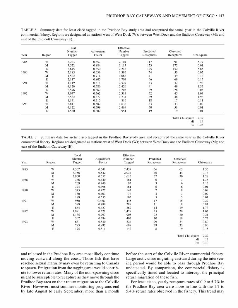
There was no significant difference between the ex-pected and observed number of tag returns in the ColvilleRiver commercial fishery for either least cisco (p = 0.25,Table 2) or arctic cisco (p = 0.30, Table 3). The six-yearstudy of arctic cisco was based upon a total of 20 391tagged fish released in the Prudhoe Bay area against 355recaptures. Correction for gear selectivity yielded an ef-fective release number of 12 028 fish, which translatedinto an overall recapture rate of 3.0%. Yearly recapturerates ranged from 2.3% in 1988 to 5.6% in 1990. In fiveyears, 41 251 (28 209 corrected) tagged least cisco werereleased in Prudhoe Bay and 903 were recaptured in thefall fishery, for an overall recapture rate of 3.2%. Yearlyrecapture rates ranged from a low of 1.7% in 1991 to a highof 5.6% in 1988.
For arctic cisco, the yearly recapture rates in this studywere notably higher than the recapture rates of ≤ 1.1% thatare typically reported for the summer monitoring studies at
FIG. 6. Simulated distances traveled by small (<180 mm) least cisco from theColville River to West Dock (~80 km) for 1988 and 1989. The distance lineterminates if the net distance traveled reaches 80 km before 31 July. Histogramsrepresent observed daily CPUE (fish·net-1·24 h-1) at fyke nets located west ofWest Dock. Absence of a CPUE baseline indicates no sampling effort. Dataindicate that the arrival of fish at the eastern end of Simpson Lagoon wasreasonably consistent with the wind transport model of Fechhelm et al. (1994)in both years.
FIG. 7. Simulated distances traveled by small (<180 mm) least cisco from theColville River through the end of July in 1988 and 1989, based upon the windtransport model of Fechhelm et al. (1994). The horizontal line at 80 kmrepresents the distance to West Dock. Data suggest that wind conditions weresufficient to carry juvenile least cisco far beyond West Dock in both years andthat their inability to bypass the causeway was probably not a result of east windevents.
conditions did not occur until the 12 July onset of sus-tained east winds.
Data for 1993 illustrate the subtle (and at timesundetectable) scope of the wake-eddy effect and its poten-tial to influence least cisco dispersal. For example, it wasasked why in 1988 least cisco arrived west of West Docksix to seven days prior to the sharp increase in salinity, yetfew managed to move east of the causeway (see Fig. 5).This is in contrast to 1990 and 1991, when it took the fishonly two or three days to move east of West Dock underconditions of low salinity. One possibility is that brief eastwind events in 1988 (Fig. 8, lower panel) may haveresulted in higher salinities at the tip of West Dock—conditions that could have prevented juvenile least ciscofrom moving east of the causeway.
Certainly, factors other than those addressed in our“wake-eddy” conceptual model play a role in the overalldynamics of the least cisco feeding dispersal, and somemay affect the ability of juvenile fish to move east of WestDock. However, collectively, the events and conditionsthat occurred in the summers of 1988 – 91 provide a rea-sonable argument for the idea that the high-salinity condi-tions that develop west of West Dock under east windsblock juvenile least cisco from dispersing eastward alongthe coast.
Although the data for the Endicott Causeway are basedon only two years, they give no indication that small leastcisco were being prevented from dispersing east of theEndicott Causeway in 1990 and 1991. The reason for thismay be threefold. First, two breaches in the mainland

146 • R.G. FECHHELM et al.
FIG. 8. Hourly east/west wind conditions for selected time frames, recorded during July 1993 and 1988. Superimposed are daily bottom salinity measurementsrecorded at stations 220 and 290 (1993 only). Hash marks represent 0000 h on the designated date. Salinity values are positioned at about 0900–1100 h, theapproximate time of day when measurements were taken. Data for 1993 show that limited periods of easterly winds can cause salinity to increase sharply at thetip of the causeway (station 290) yet not influence nearly freshwater conditions at the western base of West Dock (station 220).
Prudhoe Bay (e.g., Griffiths and Gallaway, 1982; Griffithset al., 1983; Moulton et al., 1986; Cannon et al., 1987;LGL, 1992). Low return rates at Prudhoe Bay are probablyinfluenced by the migratory and dispersal behavior of thisspecies. Tagging studies have demonstrated that largearctic cisco can range along the Beaufort Sea coast for
considerable distances during summer (Craig and Mann,1974; Griffiths et al., 1975, 1977; Craig and Haldorson,1981; Griffiths and Gallaway, 1982; Griffiths, 1983; Westand Wiswar, 1985; Cannon et al., 1987; Wiswar and West,1987; Fruge et al., 1989; Underwood et al., 1995). Fish thatdisperse eastward from the Colville River and are marked
PRUDHOE BAY CAUSEWAYS AND MOVEMENT OF CISCO • 147
TABLE 2. Summary data for least cisco tagged in the Prudhoe Bay study area and recaptured the same year in the Colville Rivercommercial fishery. Regions are designated as stations west of West Dock (W); between West Dock and the Endicott Causeway (M); andeast of the Endicott Causeway (E).
Total EffectiveNumber Adjustment Number Predicted Observed
Year Region Tagged Factor Tagged Recaptures Recaptures Chi-square
1985 W 3,203 0.657 2,104 117 91 5.77M 3,522 0.884 3,113 173 172 0.01E 2,645 0.850 2,248 125 152 5.85
1990 W 2,185 0.639 1,396 54 53 0.02M 1,502 0.711 1,068 41 39 0.12E 2,117 0.805 1,704 66 69 0.15
1991 W 4,119 0.614 2,529 43 37 0.92M 4,129 0.586 2,420 41 49 1.37E 2,576 0.662 1,705 29 28 0.05
1992 W 3,037 0.762 2,314 52 45 1.03M 2,562 0.677 1,734 39 48 1.96E 1,141 0.715 816 18 17 0.11
1993 W 2,811 0.582 1,636 33 33 0.00M 4,122 0.599 2,469 50 51 0.01E 1,580 0.602 951 19 19 0.01
Total Chi-square 17.39df 14
P = 0.25
TABLE 3. Summary data for arctic cisco tagged in the Prudhoe Bay study area and recaptured the same year in the Colville Rivercommercial fishery. Regions are designated as stations west of West Dock (W); between West Dock and the Endicott Causeway (M); andeast of the Endicott Causeway (E).
Total EffectiveNumber Adjustment Number Predicted Observed
Year Region Tagged Factor Tagged Recaptures Recaptures Chi-square
1985 W 4,507 0.541 2,439 56 65 1.56M 3,756 0.542 2,034 46 44 0.13E 2,900 0.557 1,615 37 30 1.28
1988 W 366 0.440 161 6 3 1.38M 209 0.440 92 3 6 2.13E 324 0.496 161 6 6 0.01
1990 W 345 0.427 147 7 8 0.08M 180 0.403 73 4 3 0.09E 189 0.555 105 5 5 0.01
1991 W 950 0.468 445 17 15 0.22M 589 0.489 288 11 8 0.81E 864 0.427 369 14 19 1.73
1992 W 1,981 0.721 1,428 35 29 1.02M 1,135 0.797 905 22 20 0.21E 507 0.794 403 10 18 6.72
1993 W 631 0.830 524 29 34 0.80M 783 0.892 698 39 33 0.90E 175 0.811 142 8 9 0.15
Total Chi-square 19.22df 17
P = 0.30
and released in the Prudhoe Bay area most likely continuemoving eastward along the coast. Those fish that havereached sexual maturity may even be returning to Canadato spawn. Emigration from the tagging area would contrib-ute to lower return rates. Many of the non-spawning ciscomight be susceptible to recapture as they move through thePrudhoe Bay area on their return migration to the ColvilleRiver. However, most summer monitoring programs endby late August to early September, more than a month
before the start of the Colville River commercial fishery.Large arctic cisco migrating eastward during the interven-ing period would be able to pass through Prudhoe Bayundetected. By comparison, the commercial fishery isspecifically timed and located to intercept the principalreturn migration of these fish.
For least cisco, yearly recapture rates of 0.9 to 5.7% inthe Prudhoe Bay area were more in line with the 1.7 to5.4% return rates observed in the fishery. This trend may

148 • R.G. FECHHELM et al.
also reflect the dispersal characteristics of this coregonid.Whereas large arctic cisco are common all along theBeaufort Sea coast during summer, large least cisco arerelatively rare in eastern Alaska (Roguski and Komarek,1972; Griffiths et al., 1975, 1977; Griffiths, 1983; Wiswarand West, 1987; Fruge et al., 1989; Underwood et al.,1995). The implication is that the coastal foraging range ofleast cisco is more restricted than that of arctic cisco. Amore spatially restricted coastal habitat increases the prob-ability that least cisco forage in closer proximity to thePrudhoe Bay study area, thereby increasing residency timeand, in turn, the likelihood of being recaptured within thesummer. There is some indication of greater residencytime, in that the daily catch rates of large least cisco in thePrudhoe Bay area are typically much higher and morepersistent throughout the summer than those of large arcticcisco. It should be noted, however, that although thedispersal range of adult least cisco appears to be morerestricted than that of arctic cisco, least cisco can stillmigrate considerable distances along the Beaufort Seacoast during the open-water season. They have been re-ported, albeit in relatively small numbers, as far east asCamden Bay, 120 km east of Prudhoe Bay (Underwood etal., 1995).
To determine the amount of loss that would be requiredfor the chi-square test to register a significant difference intag returns at α = 0.05, given the available data, weconsidered the initial premise of the analysis. Fish dis-perse from the Colville River in early summer, whennearshore temperatures are highest and salinities lowest.They return in late summer, when coastal conditions havebecome considerably more marine. If causeways did blockthe return migration, the ratio of actual to expected returnswould be lower for fish released east of any causeway.Under this premise, we began with the assumption thateach causeway would result in a 1% loss of fish (i.e., tagreturns). That is, the actual number of tag returns wasreduced by 1% for fish released in region M and by 2% forfish released in region E. We made this adjustment forevery study year and recalculated the subsequent chi-square probability. This process was repeated, progres-sively increasing the percent loss by 1% at each iteration.
The plot of chi-square p-values versus assumed percentloss indicates that, for both species and given the availabledata, a causeway would have to result in about a 24 – 25%loss for the test to register a significant difference at p ≤0.05 (Fig. 9). Given this estimate, overall results suggestthat while there is no indication of a major causewayeffect, population losses of 10 – 20%, losses that couldaffect population structure, would go undetected. On theother hand, the actual total return rates for fish releasedfarthest from the Colville River, east of the EndicottCauseway, were higher than expected for arctic cisco (80expected versus 87 observed) and nearly neutral for leastcisco (187 expected versus 186 observed). Neither set ofvalues suggests a loss of fish related to the locations of thetwo causeways. Further, if losses of 10 – 20% did occur,
FIG. 9. Distribution of chi-square probabilities under the assumption thatcauseways result in the indicated percentage loss of tagged fish. Data suggestthat, for both Arctic and least cisco, losses of 24–25% would be required for thechi-square test to detect a significance at the α = 0.05 level.
there would almost certainly be some tangible impact tothe commercial fishery. Yet, through 30 consecutive yearsof monitoring the fishery, there has been no discerniblechange in the annual harvests of least or arctic cisco relatedto the construction of either West Dock or the EndicottCauseway (Moulton and Helmericks, 1997).
GENERAL DISCUSSION
Spatial patterns in catch and hydrographic data aregenerally consistent with the idea that causeway-inducedchanges in local salinity can disrupt the eastward foragingdispersal of juvenile least cisco emanating from the ColvilleRiver. Analysis of commercial fishery tag recaptures indi-cated no significant difference in the return rates of subadultand adult least and arctic cisco based upon the location ofrelease relative to either the West Dock or Endicott cause-ways. Although the tag recapture analysis has its limita-tions in sensitivity, even the trend in tag losses wasinconsistent with the underlying hypothesis that the PrudhoeBay causeways prevented fish from returning to the ColvilleRiver in late summer. Results of the mark-recapture analy-sis agree with those reported by Craig and Griffiths (1981)and Cannon and Hachmeister (1987), each of which wasbased on a single-year study, and with those of Fechhelmet al. (1989), who analyzed tag returns relative to WestDock alone covering the pre-Endicott years 1981 – 84.
The results of both analyses tend to support the idea thatlarge fish appear to be able to bypass the Prudhoe Bay areacauseways, but juvenile fish can encounter causeway-induced conditions that can block alongshore dispersal. Itseems reasonable that large fish are able to bypass areacauseways, given their swimming capacities. Summerfeeding dispersals may take adults hundreds of kilometresfrom their overwintering sites, along an irregular coastlinecharacterized by diverse bathymetic and topographicalfeatures. Unlike juveniles, large least cisco are present

PRUDHOE BAY CAUSEWAYS AND MOVEMENT OF CISCO • 149
throughout the Prudhoe Bay study area every summer(e.g., Griffiths and Gallaway, 1982; Griffiths et al., 1983;Moulton et al., 1986; Cannon et al., 1987; Glass et al.,1990; Reub et al., 1991; LGL, 1992; Griffiths et al., 1996).They have been taken in substantial numbers as far east asMikkelsen Bay, some 40 km east of West Dock (Fechhelmet al., 1996). Large arctic cisco are common in the coastalwaters of eastern Alaska near the Arctic National WildlifeRefuge (West and Wiswar, 1985; Wiswar and West, 1987;Fruge et al., 1989; Underwood et al., 1995). Upon reachingsexual maturity, arctic cisco are believed to migrate over600 km from the Colville River back to their natal drainagesin the Mackenzie River system, Canada (Gallaway et al.,1983). Given the distances involved, the Prudhoe Baycauseways would appear to be a minor obstacle to disper-sal and migration.
If the events of 1988 and 1989 do indicate blockage atWest Dock for juvenile least cisco, the long-term reper-cussions of this phenomenon for the least cisco populationremain unclear. Fish monitoring studies have been con-ducted in the Prudhoe Bay area each summer since 1981,yet over those 16 years (through 1996) blockage at WestDock has been evident only twice. Because of summerwind/transport conditions, juvenile least cisco do not evenreach West Dock in one of every two years (Fechhelm etal., 1994). If blockage were more chronic, it would heightenconcern that disruptions to the summer feeding dispersalsof the Colville River least cisco were placing the popula-tion at risk over the long term. The history of studysuggests that blockage is a rare event and, as such, prob-ably does not constitute an appreciable effect on summerfeeding dispersals (Wilson and Gallaway, 1997). On theother hand, the mere fact that there is evidence of block-age, no matter how rarely that might occur, evokes thepossibility that more subtle and undetectable disruptionsto dispersal could be occurring.
Comparisons of side-of-causeway CPUE, as was donefor juvenile least cisco in this paper, are not applicable toadults, nor do they apply to the other key diadromousspecies of the region—Dolly Varden (Salvelinus malma),broad whitefish (C. nasus), and arctic cisco (as identifiedby U.S. Army Corps of Engineers, 1980, 1984). Residentpopulations of all three species either spawn or overwinterin both the Sagavanirktok and Colville Rivers (e.g., Griffithset al., 1983; Craig, 1984; Moulton et al., 1986; Cannon etal., 1987; Glass et al., 1990; Reub et al., 1991; LGL, 1992;Griffiths et al., 1996). The effort to identify movementpatterns of these three species is confounded by the mixingof stocks and the inability to distinguish fish of a purelyColville River or Sagavanirktok River origin. Further,once fish are distributed throughout the study area, dailyvariation in CPUE is large enough to preclude side-of-causeway statistical comparisons. Because they overwinterin the Sagavanirktok River, all three species are commonthroughout the Prudhoe Bay area as soon as sampling canbegin, which is shortly after breakup. Juvenile least ciscoare the only group that is completely absent from Prudhoe
Bay waters in very early summer and arrives in the areaonly from the west. Subadult and adult arctic cisco alsooriginate from the Colville River. These large fish do notoverwinter extensively in the Sagavanirktok River (Schmidtet al., 1989); however, they disperse out into coastalwaters very early and are typically present throughout thePrudhoe Bay area when sampling begins each summer.
Although we continually refer to the water quality issueat West Dock in terms of salinity, there is, in fact, a morethan occasional correlation between the wake-eddy effectand temperature: salinity and temperature are often in-versely related. However, high-salinity water that movesinto nearshore shallow areas can heat up quite rapidly,particularly on warm, sunny days. This leads to “numerousanomalies” in the wake eddy/salinity/temperature asso-ciation. It is quite feasible that the cold temperatures andhigh salinities that characterize marine water can act to-gether in influencing the movements of juvenile fish. It isjust that, quantitatively, the most convincing trends in thevicinity of West Dock are evident in salinity patterns.
If the interpretations and conclusions expressed in thispaper are correct, the implications are that the potentialimpacts of a causeway on Beaufort Sea fish populationsare strongly related to the locations of the causeway itselfand the size of the fish encountering it. West Dock wasconstructed within the dispersal range of a diadromousspecies, at the eastern terminus of an extensive brackish-water lagoon system through which fish disperse andmigrate, and seaward enough into the marine system toexacerbate coastal mixing processes. The Endicott Cause-way, on the other hand, was constructed entirely on ashallow-water shelf, was fitted with breaches, and is con-stantly bathed in freshwater discharge from theSagavanirktok River. Fish movement around and throughthe Endicott Causeway is less restricted. Given such dif-ferences, factors such as location, bathymetry, and coastaltopography should be major considerations in the planningof any future developments along the Beaufort Sea coast.
As mentioned previously, a 200 m wide breach wasinstalled in the base of West Dock during the winter 1995 –96. The extent to which this breach may alleviate theapparent blockage of juvenile least cisco remains to bedetermined. If historical records are any indication, onewould have to wait, on average, eight years to find out.
ACKNOWLEDGEMENTS
We thank J. Erwin and G. Hubbard for critically reviewing themanuscript. We are also grateful to field managers D. Schmidt andR. Dillinger; senior field crew leaders B. Seavey, K. Waggoner, andDon Campbell; field team leaders G. Colonell, B. Colthorp, G.Lawley, and D. Malone; field technicians T. Akpik, R. Basi, M.Bingham, J. Bush, M. Cole, S. Davis, L. Dugan, P. Fitzgerald, D.Gerkin, T. Green, B. Haley, A. Herrera, D. Hopler, J. Itta, S.Kilmowski, E. Parsons, B. Pierson, D. Rentenaar, D. Rosenau, andE. Westlien; and, expediter D. Roche for their superb efforts during

150 • R.G. FECHHELM et al.
the 1988 – 94 studies. Environmental monitoring programs werefunded by the owners of the Endicott Development, which isoperated by BP Exploration (Alaska) Inc. Programs conductedfrom 1985 to 1987 were under the joint supervision of the AlaskaDepartment of Fish and Game, the U.S. Environmental ProtectionAgency, the National Marine Fisheries Service, the North SlopeBorough (NSB), the U.S. Army Corps of Engineers, and the U.S.Fish and Wildlife Service. Environmental monitoring programsfrom 1988 to 1996 were conducted under permit requirements andsupervision of the NSB and the NSB Science Advisory Committee.The conclusions and opinions expressed in this paper do notnecessarily represent those of any of the above-mentionedorganizations.
REFERENCES
CANNON, T.C., and HACHMEISTER, L.E. 1987. Integration andassessment. Vol. 1, chapter 2. In: 1985 Final Report for theEndicott Environmental Monitoring Program. Unpubl. report.Available at Envirosphere Company, 10900 8th Street, Bellevue,Washington, 98004-4405, U.S.A. 1 –129.
CANNON, T.C., ADAMS, B., GLASS, D., and NELSON, T. 1987.Fish distribution and abundance. Vol. 6, chapter 1. In: 1985Final Report for the Endicott Environmental Monitoring Program.Unpubl. report. Available at Envirosphere Company, 10900 8thStreet, Bellevue, Washington, 98004-4405, U.S.A. 1 – 28.
COLONELL, J.M., and GALLAWAY, B.J. 1997. Wind-driventransport and dispersion of age-0 arctic cisco along the BeaufortSea coast. American Fisheries Society Symposium 19:90 –103.
———. 1989. An introduction to anadromous fishes in the AlaskanArctic. Biological Papers of the University of Alaska 24:27 –54.
CRAIG, P.C., and GRIFFITHS, W.B. 1981. Passage of large fisharound a causeway in Prudhoe Bay, Alaska. Arctic 34:314– 317.
CRAIG, P.C., and HALDORSON, L. 1981. Beaufort Sea barrier-island lagoon ecological process studies: Simpson Lagoon. Part4. In: Environmental assessment of the Alaskan ContinentalShelf, No. 7. Boulder, Colorado: Bureau of Land Management/National Oceanic and Atmospheric Administration, OuterContinental Shelf Environmental Assessment Program. 384–678.
CRAIG, P.C., and MANN, G.J. 1974. Life history and distributionof arctic cisco (Coregonus autumnalis) along the Beaufort Seacoastline in Alaska and the Yukon Territory. Arctic Gas BiologicalReport Series 20. 27 p.
FECHHELM, R.G., and FISSEL, D.B. 1988. Wind-aidedrecruitment of Canadian arctic cisco (Coregonus autumnalis)into Alaskan waters. Canadian Journal of Fisheries and AquaticSciences 45:906 –910.
FECHHELM, R.G., and GRIFFITHS, W.B. 1990. The effect ofwind on the recruitment of Canadian arctic cisco (Coregonusautumnalis) into the central Alaskan Beaufort Sea. CanadianJournal of Fisheries and Aquatic Sciences 47:2164 –2171.
FECHHELM, R.G., BAKER, J.S., GRIFFITHS, W.B., andSCHMIDT, D.R. 1989. Localized movement patterns of leastcisco (Coregonus sardinella) and arctic cisco (C. autumnalis) inthe vicinity of a solid-fill causeway. Biological Papers of theUniversity of Alaska 24:75 –106.
FECHHELM, R.G., BRYAN, J.D., GRIFFITHS, W.B.,GALLAWAY, B.J., and WILSON, W.J. 1994. The effects ofcoastal winds on the summer dispersal of least cisco (Coregonussardinella) from the Colville River to Prudhoe Bay, Alaska: Asimulation model. Canadian Journal of Fisheries and AquaticSciences 51:890 –899.
FECHHELM, R.G., GRIFFITHS, W.B., WILSON, W.J., TRIMM,B.A., and COLONELL, J.M. 1996. The 1995 Fish andoceanography study in Mikkelsen Bay, Alaska. Unpubl. report.Available at LGL Alaska Research Associates, 4175 TudorCentre Drive, Anchorage, Alaska 99508, U.S.A.
FRUGE, D.J., WISWAR, D.W., DUGAN, L.J., and PALMER,D.E. 1989. Fish population and hydrographic characteristics ofArctic National Wildlife Refuge coastal waters, summer 1988.Unpubl. report. Available at the Fishery Assistance Office, U.S.Fish and Wildlife Service, Room 110, 101 12th Avenue,Fairbanks, Alaska 99701, U.S.A.
GALLAWAY, B.J., GRIFFITHS, W.B., CRAIG, P.C., GAZEY,W.J., and HELMERICKS, J.W. 1983. An assessment of theColville River Delta stock of arctic cisco: Migrants from Canada?Biological Papers of the University of Alaska 21:4 –23.
GALLAWAY, B.J., GAZEY, W.J., COLONELL, J.M.,NIEDORODA, A.W., and HERLUGSON, C.J. 1991. TheEndicott Development Project: Preliminary assessment ofimpacts from the first major offshore oil development in theAlaskan Arctic. American Fisheries Society Symposium11:42 –80.
GLASS, D., WHITMUS, C., and PREWITT, M. 1990. Fishdistribution and abundance. Vol. 5, chapter 1. In: 1986 FinalReport for the Endicott Environmental Monitoring Program.Unpubl. report. Available at Envirosphere Company, 10900 8thStreet, Bellevue, Washington, 98004-4405, U.S.A. 1 – 154.
GRIFFITHS, W.B. 1983. Fish. In: Environmental characterizationand biological use of lagoons in the eastern Beaufort Sea.Unpubl. Rep. by LGL Ecological Research Assoc., Inc. Availableat National Oceanic and Atmospheric Administration/OuterContinental Shelf Environmental Assessment Program, Officeof Marine Pollution Assessment, P.O. Box 1808, Juneau, Alaska.99802, U.S.A. 176 –222.
GRIFFITHS, W.B., and GALLAWAY, B.J. 1982. Prudhoe BayWaterflood fish monitoring program 1981. Unpubl. report.Available at LGL Alaska Research Associates, 4175 TudorCentre Dr., Anchorage, Alaska 99508, U.S.A.
GRIFFITHS, W.B., CRAIG, P., WALDER, G., and MANN, G.1975. Fisheries investigations in a coastal region of the BeaufortSea (Nunaluk Lagoon, Yukon Territory). Arctic Gas BiologicalReport Series 34.
GRIFFITHS, W.B., DEN BESTE, J.K, and CRAIG, P. 1977.Fisheries investigations in a coastal region of the BeaufortSea (Kaktovik Lagoon, Alaska). Arctic Gas Biological ReportSeries 40.
GRIFFITHS, W.B., SCHMIDT, D.R., FECHHELM, R.G.,DILLINGER, R.E., NEILL, W.H., GAZEY, W., and BAKER,J.S. 1983. Fish ecology. Vol. 3. In: Environmental summerstudies (1982) for the Endicott Development. Unpubl. report.Available at LGL Alaska Research Associates, 4175 TudorCentre Dr., Anchorage, Alaska 99508, U.S.A.

PRUDHOE BAY CAUSEWAYS AND MOVEMENT OF CISCO • 151
GRIFFITHS, W.B, FECHHELM, R.G., MARTIN, L.R., andWILSON, W.J. 1996. Fish and hydrography data report. Vol. 1.In: The 1995 Endicott Development Fish Monitoring Program.Unpubl. report. Available at LGL Alaska Research Associates,4175 Tudor Centre Dr., Anchorage, Alaska 99508, U.S.A.
HACHMEISTER, L.E., GLASS, D.R., and CANNON, T.C. 1991.Effects of solid-gravel causeways on the coastal central BeaufortSea Environment. American Fisheries Society Symposium11:81 – 96.
LGL (LGL ALASKA RESEARCH ASSOCIATES, INC.). 1992.Analysis of fyke net data. Vol. 2. In: The 1990 EndicottDevelopment Fish Monitoring Program. Unpubl. report.Available at LGL Alaska Research Associates, 4175 TudorCentre Dr., Anchorage, Alaska 99508, U.S.A.
MANGARELLA, P.A., HARPER, J.R., and WEINGARTNER,T.G. 1982. Prudhoe Bay Waterflood Project Physical ProcessesMonitoring Program, 1981. Appendix A. Unpubl. report.Available at U.S. Army Corps of Engineers, Pouch 898,Anchorage, Alaska 99506, U.S.A.
MOULTON, L.L. 1989. Recruitment of arctic cisco (Coregonusautumnalis) into the Colville Delta, Alaska, 1985. BiologicalPapers of the University of Alaska 24:107 –111.
———. 1995. The 1994 Colville River fishery. Vol. 2. In: The 1994Endicott Development Fish Monitoring Program. Unpubl. report.Available at MJM Research, 5460 NE Tolo Road, BainbridgeIsland, Washington 98110, U.S.A.
MOULTON, L.L., and FIELD, L.J. 1994. The 1992 Colville Riverfishery. Vol. 2. In: The 1992 Endicott Development FishMonitoring Program. Unpubl. report. Available at MJMResearch, 5460 NE Tolo Road, Bainbridge Island, Washington98110, U.S.A.
MOULTON, L.L., and HELMERICKS, J.W. 1997. The 1997Colville River fishery. Vol. 2. In: The 1997 Endicott DevelopmentFish Monitoring Program. Unpubl. report. Available at MJMResearch, 5460 NE Tolo Road, Bainbridge Island, Washington98110, U.S.A.
MOULTON, L., GALLAWAY, B., FAWCETT, M., GRIFFITHS,W., CRITCHLOW, K., FECHHELM, R., SCHMIDT, D., andBAKER, J. 1986. 1984 Central Beaufort Sea fish study. Vol. 2,Chap. 3. In: Prudhoe Bay Waterflood Project EnvironmentalMonitoring Program 1984. Unpubl. report. Available at LGLAlaska Research Associates, 4175 Tudor Centre Dr., Anchorage,Alaska 99508, U.S.A.
NIEDORODA, A.N., and COLONELL, J.M. 1990. Beaufort Seacauseways and coastal ocean dynamics. In: Chakrabartl, S.K.,Magda, H., Aage, C., and Neilsen, F.G. eds. Proceedings of theNinth International Conference of Offshore Mechanical andArctic Engineering, Book No. 10296B. New York, New York:American Society of Mechanical Engineers. 509 –516.
OSTLE, B., and MENSING, R.W. 1975. Statistics in Research.Ames, Iowa: The Iowa State University Press.
REUB, G.S., DURST, J.D., and GLASS, D. 1991. Fish distributionand abundance. Vol. 6, chapter 1. In: 1987 Final Report for theEndicott Environmental Monitoring Program. Unpubl. report.Available at Envirosphere Company, 10900 8th Street, Bellevue,Washington, 98004-4405, U.S.A. 1 –60.
RICKER, W.E. 1975. Computation and interpretation of biologicalstatistics of fish populations. Bulletin of the Fisheries ResearchBoard of Canada 191.
ROGUSKI, E.A., and KOMAREK, E. 1972. Monitoring andevaluation of Arctic waters with emphasis on North Slopedrainages. Alaska Department of Fish and Game, Annual Report12:1 – 22.
SAVOIE, M.A., and WILSON, D.C. 1983. Prudhoe Bay WaterfloodProject Physical Processes Monitoring Program, 1982. Unpubl.report. Available at U.S. Army Corps of Engineers, Pouch 898,Anchorage, Alaska 99506, U.S.A.
———. 1986. Prudhoe Bay Waterflood Project Physical ProcessesMonitoring Program, 1984. Unpubl. report. Available at U.S.Army Corps of Engineers, Pouch 898, Anchorage, Alaska99506, U.S.A.
SCHMIDT, D.R., GRIFFITHS, W.B., and MARTIN, L.R. 1989.Overwintering biology of anadromous fish in the SagavanirktokRiver delta, Alaska. Biological Papers of the University ofAlaska 24:55 – 74.
SCHMIDT, D., GRIFFITHS, W.B, BEAUBIEN, D.K, andHERLUGSON, C.J. 1991. Movement of young-of-the-yeararctic ciscoes across the Beaufort Sea coast, 1985 – 1988.American Fisheries Society Symposium 11:132 –144.
UNDERWOOD T.J., GORDON, J.A., THORPE, L.A., MILLARD,M.J., and OSBORNE, B.M. 1995. Characteristics of selectedfish populations of Arctic National Wildlife Refuge coastalwaters, final report, 1988 –1991. Alaska Fisheries TechnicalReport Number 28. Fairbanks, Alaska: Fisheries Research Office,U.S. Fish and Wildlife Service.
U.S. ARMY CORPS OF ENGINEERS. 1980. Final environmentalimpact statement, Prudhoe Bay oil field, Waterflood project.Anchorage, Alaska: U.S. Army Corps of Engineers, AlaskaDistrict.
U.S. ARMY CORPS OF ENGINEERS. 1984. Final environmentalimpact statement, Prudhoe Bay oil field, Endicott developmentproject. Anchorage, Alaska: U.S. Army Corps of Engineers,Alaska District.
WEST, R.L., and WISWAR, D.W. 1985. Fisheries investigationson the Arctic National Wildlife Refuge, Alaska, 1984. In:Garner, G.W. and Reynolds P.E., eds. Arctic National WildlifeRefuge coastal plain resource assessment: 1984 update report.Anchorage, Alaska: U.S. Fish and Wildlife Service. 729 –777.
WILSON, W.J., and GALLAWAY, B.J. 1997. Synthesis in appliedfish ecology: Twenty years of studies on the effects of causewaydevelopment on fish populations in the Prudhoe Bay region,Alaska. American Fisheries Society Symposium 19:326 –339.
WISWAR, D.W., and WEST, R.L. 1987. Fisheries investigationson the Arctic National Wildlife Refuge, Alaska, 1984. In:Garner, G.W., and Reynolds, P.E., eds. Arctic National WildlifeRefuge coastal plain resource assessment: 1985 update report.Anchorage, Alaska: U.S. Fish and Wildlife Service. 778 –800.