prosp rpt little sturge lake area - search ... claim # 3007095 little sturge lake area nipigon...
TRANSCRIPT
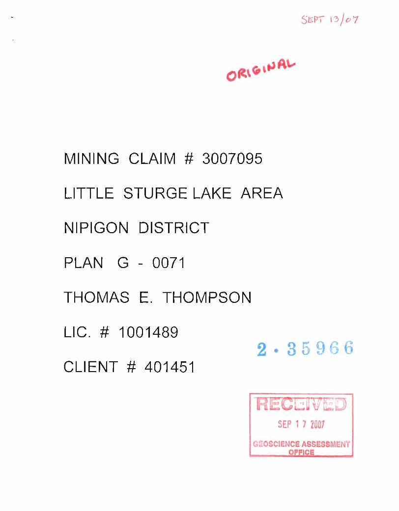
MINING CLAIM # 3007095
LITTLE STURGE LAKE AREA
NIPIGON DISTRICT
PLAN G - 0071
THOMAS E. THOMPSON
LIC. # 1001489
CLIENT # 401451
SE~ 1 J 2007
G -OSCIENCE ASSES MENY
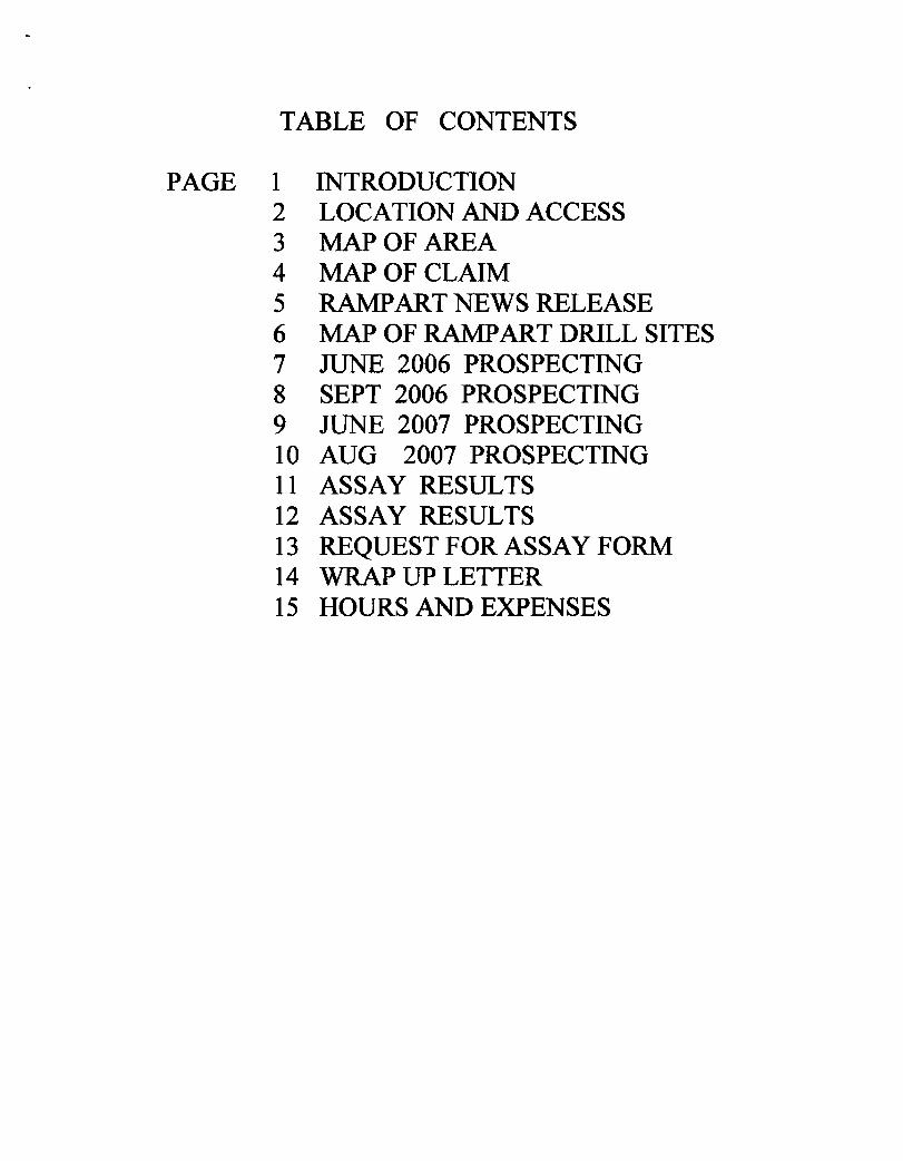
TABLE OF CONTENTS
PAGE 1 INTRODUCTION 2 LOCATION AND ACCESS 3 MAP OF AREA 4 MAP OF CLAIM 5 RAMP ART NEWS RELEASE 6 MAP OF RAMPART DRILL SITES 7 JlTNE 2006 PROSPECTING 8 SEPT 2006 PROSPECTING 9 JUNE 2007 PROSPECTING 10 AUG 2007 PROSPECTING 11 ASSAY RESULTS 12 ASSAY RESULTS 13 REQUESTFORASSAYFORM 14 WRAP UP LETTER 15 HOURS AND EXPENSES
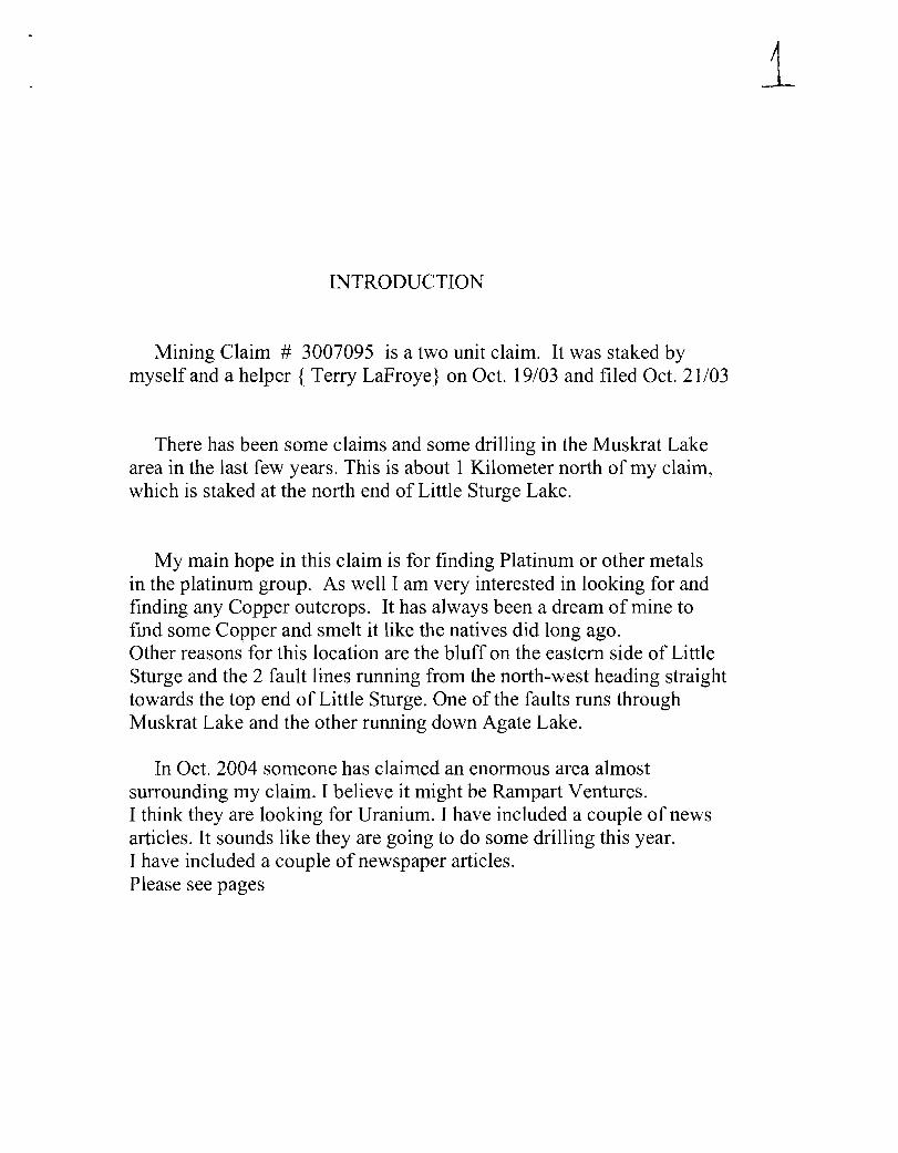
INTRODUCTION
Mining Claim # 3007095 is a two unit claim. It was staked by myself and a helper { Terry LaFroye} on Oct. 19/03 and filed Oct. 21/03
There has been some claims and some drilling in the Muskrat Lake area in the last few years. This is about 1 Kilometer north of my claim, which is staked at the north end of Little Sturge Lake.
My main hope in this claim is for finding Platinum or other metals in the platinum group. As well I am very interested in looking for and finding any Copper outcrops. It has always been a dream of mine to find some Copper and smelt it like the natives did long ago. Other reasons for this location are the bluff on the eastern side of Little Sturge and the 2 fault lines running from the north-west heading straight towards the top end of Little Sturge. One of the faults runs through Muskrat Lake and the other running down Agate Lake.
In Oct. 2004 someone has claimed an enormous area almost surrounding my claim. I believe it might be Rampart Ventures. I think they are looking for Uranium. I have included a couple of news articles. It sounds like they are going to do some drilling this year. I have included a couple of newspaper articles. Please see pages
i

LOCATION AND ACCESS
Mining Claim # 3007095 is located on the north-east side of Little Sturge Lake, in the Nipigon District. Please refer to Plan G - 0071 and to other maps in this report.
545500 Nand 362000 E are aproximately the dead center of the claim.
To access the Claim from Thunder Bay, you must drive 70 KM East on the Trans Canada to the Black Sturgeon tum off, then North on the Black Sturgeon road for 62 KM and then make a left tum. Then travel westerly 18 KM on less traveled roads. There are no road signs on these roads and there are lots of forks and turns.
It takes an average of 2.5 hours to make the 150 KM trip to get to the Claim site, so the round trip is 5 hours and 300 KM

Tho ... wi1hInQ to ake mining daims lIhould con.,11 wilh rh. PrO\4ndal Mining I'tlKOl'"d ... • Offtce of the Minitill)' of Nor1:tt4rn ~opm .... t and Mil"les fO( additional infOf'mation on the ,Blus of the lands !hown hereon . This map is nOC Intended for navigaUonal . SJ~. or larnj title det..-mlneliOfl purposes as rtJe infotmation ~own on thi_ map i. compiled from various $OI.Irce • . Compl.c.., ... and aCOJracy are nOl: gue,.nteed . Additional lnformatjon may .I-so be obtained through the local land Titles Of' Regi!l:ry OffIce. or the Mimalry of Natural Resources..
The k\fonnation ~own (5 denv.d from digital data 8\/ailable In 1M Pfo\/incia' Mining R.;:order,.: orftoe at the time of downloading from the Minittty of Northern Oevetopmanl and Mines web site .
Geoerallntormatkln And U,nitations Contact Infomtation: Provind.' MininQ Record.,...' OfFice Willet Green Min .. Centre 933 Ramsey Lake Ro.ad SlJdblMY ON P3E 685
Toll Fr.. Mep t)IIuift: NAO 83 Tel: 1 (88~) 415-Q~5 eld .51ItJiedjon: o.o..raphlc Coocdtnatee. FaK: 1 (877) 610-'"'' Top01ll.r.."..c Deta Source: LliN'ld infonTlation Ontario
Mining l2md Tenure Sotxc.: Provincial !\lining Recorder.' Office Home Page: www.mndm.gov.on.CIIIMNDMIl.4INESI1...ANOSImisn"PQ • . ntm
This map may not 1how \.lnregilh".o land tenure .,...d interests In land Induding certain patef'lts.. lea ••. Nsements., right of ways. flooding right •. lioenoes, or other forms of dtlPosilJon of rights and intere31 from the Crown. Also certain land tenure and land uses rtlat restrid: or prohibit fr-e. entry to "ake mIning daims may not b. irlustrated.
ONThaIO CANADA
__ 1WY __ TMRMJ
-~...,-. ...... CIM._. ........... -Date I TIme of Issue: Sun Mar CM 2J :~ 1 :4~ EST 2007
TOWNSHIP I AREA LITTLE STURGE LAKE AREA
Mining Land Tenure Map
PLAN 0-0811
ADMINISTRATIVE DISTRICTS' DIVISIONS
Mining Division
Land TillesfRegislry Division
Ministry of Natural Resources District
TOPOGRAPHIC
Administflltive Boundaries
TownShip
Clitt Pit, Pi/oe
Contour
Mine Shafts
Mrne~
Rood
Tra~
+
.... ·.
Thunder Bay
THUNDER BAY
NIPIGON
Land Tenure
Mining Rights Only
L8IIIehotd Patent
•
El fJ
Sorfao!! And Uining Rights
OrOer In Council (Not OPen lor ata.king)
,------ -- j ~ __ 1:~~: __ : ---------, ~ __ 1~:'~ __ ~ LAND TENURE WITHDRAWAlS
~ Alees Withdrawn from Oi.pot:i!;on
w ... w. Wm
Wirllog Ads Wrthd"wal Ty,*, Sutt.oe AN MInIng R)gh15 WI.'1." .... m ~R~tlOrwyWiIMlr;rwn lt4n.ng Rignla Onty Wlf><bwn
Order In Council WIthdraw. Typeli ~ And MlNng RiOrIts WlhdIWwn SurtIu ~Ia CWy Wt~ Mi!\il'oli R><;;1- 0ni1 Wibnwn
IMPORTANT NOTICES
J.".

® 0 0
00000(10 00
3"'P ~ pcPLAa..
~
LAK£
PGc* Lf ~PT 13/07
" 1/
"
® J
~ C (1
J * FA\...t.UJ I~ V
t;vJAMP C +- DIGG.t-lCS
0 <, + <;r-\Mr~'5 )( 3 0
0 ~
0 " u '> 0 0 0
C (. 0° POPL.A~ > ty'Il,I.\;1) j
l
~~~~.~~~~~~~-~ for cA"- ~ "', .. b
@ noL ® o t c oj ~ ~ 0 0
$<lJnMP /f R.v~ cFP ., .,lP
30 C i'f\ .) .... AMr tNrJ oJ'J' WIDe:
/I
®
I
/
, \
of - OETlllllL S~l)l",~~rR\{ - CON6LoMEIMfE 13R.&;c..IA (flU S12i:6 )
_ M!;TfI _ PLvfo/\J\C HD(lNI3L.£N~ (;'Ll. S .Zi.';)
IGN~Ov.s _ VOI...CANIC ()/hAt..T' SC.A<lf\ (AU .. S iZC.-';)
_ "yJMI rEf t- c. ... {;JIIa. Q~"'~:fZ. (':)/C\f\JO $ 'ZE:) _ F~QQ.\JG,NOuS CHt;tZT (Pl:ilM3t.E ro S"''''u ~JIZ£)
,I /I
3 vJAS~ e,Ofl.E.i.) iiDi..65 -rD .a' OEP-(H - AREA J=" " " .* FALt..~NntE.~ r O~G'IJ'lGS + 5AMPl..~S SEN', Fv£. ArvAt..'t'StS - AQ.~A C
... ." II ':.' Ii .. " "
OCODO S VJAM P - A~~S' (\ 1'\ F, G .. " \!" I,
__ ... _ _ SIt'lGLf. L..AtJE DIRT"" R.oAQ - AR.~t1S 'D ,~ H
-----, ------....... I'
Uf.,li.)SA0i-E SK,bOER ·~AlL.. - t\e.EA D
I
I

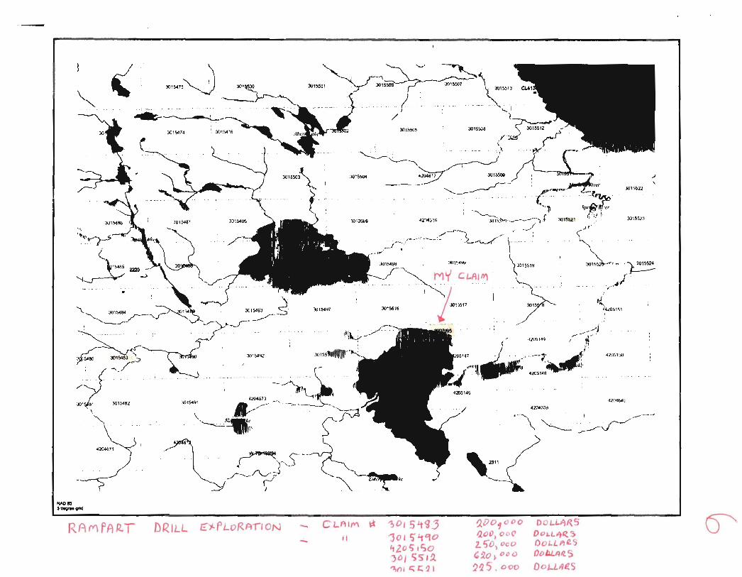
Rampart Ventures Ltd. - Sibley Hasin - .Fri Jul 28,2006
FAQ Contact Us Site Index Search
About l"~ Investor Relation - Properties _-\.uOllt lOr un c act
Home > Sibley Basin >
5101 asrn Sibley Basin Project, Northwestern Ontario
Last year, Rampart Ventures geologists made what they believe to be the most significant Canadian uranium discovery outside of the Athabasca basin.
Preliminary results from the BLACK STURGEON PROPERTY, which covers approximately 4200 acres in Northwestern Ontario's SIBLEY BASIN, indicate what appears to be a great potential to host a multi-billion dollar uranium deposit.
An airborne VTEM survey defined several high priority conductors which are interpreted to be gaphitic units underlying the Sibley Basin rocks. As well, it defined multiple bands of magnetic Iron formation which provide an excellent environment for uranium In the area.
The 2005 Phase I Drill Program in the SIBLEY BASIN also showed :
• 2.99% U308 over 1.5 m; and, • 11 out of 22 holes encountered 0.10% of U308 or greater.
Since then, 7.5 million dollars has been raised, and Rampart Ventures is prepared to commence with a $1,25 million Phase II drill program.
The Sibley Basin, sometimes referred to as the Nipigon Basin, is a Helikian-age continental sedimentary basin that shows a number of similarities to the Athabasca basin In Saskatchewan (more below)
Rampart Ventures Ltd. has entered into a jOint venture agreement with New Shoshoni Ventures Ltd. on the Wolfpup Lake and Black Sturgeon West claim groups covering approximately 8,400 acres in the Sibley Basin. Rampart has also entered into two other agreements to acqUire six additional uranium properties totaling approximately 28,200 acres in the Sibley basin.
GEOLOGICAL TWINS? THE SIBLEY BASIN COMPARED TO THE URANIUM --RICH ATHABASCA BASIN Located in northwestern Ontario, the Sibley Basin (sometimes referred to as the Nipigon Basin) shows a number of similarities to the uranium-rich Athabasca Basin in northern Saskatchewan.
The Athabasca Basin is home to the largest high grade uranium depOSits in the world.
These similarities have long been recognised and led to a modest amount of exploration for uranium in the area in the late 19705 and early 19805. From a geological standpoint, Similarities between the Athabasca and Sibley/Nipigon basins include:
• Both areas are un metamorphosed, continental sedimentary basins; • Both basins were formed during the Helikian age (the Athabasca Formation 1,350 my,
http://www.rampartventures.com/slN ipigon-Sibley Basin.asp
5
> Our PropertiE Sibley Basin
Richards Lake
Bearhead Lake
Max Lake
Maps & Images
28/07/2006
~ . ",.,,~ o j- _ • . ~ •• " .- • • ~ .•
~~-J01~74
DRILL c)l-PLoRAl'lON
.)011009
-it
eJ)~b< ...
42l>46'H
~OI5Lt<J3 'jOI5''t90 Lt2. o l).So )D/ SS' I .Q, 'It{) I "~'1 I
, ~ .. ,'l . 4;t05,.,q ~ .... J..-" ,.,.. .
,. ... ..,.' . : ' --~' '...;.I~ '1- ' ' .;t051<6~ll'
, ..
'J,OO"ODO /),OO.O OC'
2. 50, CeO
':'20). DCO
215 . oec
00 L.L.,t)RS
D01.L4~ So OOl.LJPJIlS
O() bJ../M.$
DOl-UU~S
3O'~523
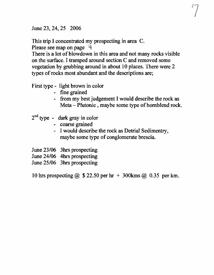
June 23, 24, 25 2006
This trip I concentrated my prospecting in area C. Please see map on page 4 There is a lot of blowdown in this area and not many rocks visible on the surface. I tramped around section C and removed some vegetation by grubbing around in about 10 places. There were 2 types of rocks most abundant and the descriptions are;
First type - light brown in color - fine grained - from my best judgement I would describe the rock as
Meta - Plutonic, maybe some type of hom blend rock.
2nd type - dark gray in color - coarse grained - I would describe the rock as Detrial Sedimentry,
maybe some type of conglomerate brescia.
June 23/06 3hrs prospecting June 24/06 4hrs prospecting June 25/06 3hrs prospecting
10 hrs prospecting @ $ 22.50 per hr + 300kms @ 0.35 per km.
7

Sept. 26, 27, 28 2006
I spent this trip in section C again. The Dec. 17/03 analysis of a rock from this section had showings of 2213 ppm of phosphorus, 2842 ppm of titanium, and 5.76 % ferris. Maybe these good readings are an indication of something. During the last ice age I believe that Muskrat Lake at one time emptied into Little Sturge in or around this location. Hence my dry creek theory. While prospecting in section C I found a rock stuck in the root of a tree that had blown over. I collected it and brought it in for analysis. Please see pages \ \ + \ fJ.- for the results. My description of the rock is - medium gray color
- fme grained - I would say Igneous-Volcanic - maybe tuff or basalt scoria
Sept. 26/06 3hrs prospecting Sept. 27/06 3 hrs prospecting Sept. 28/ 06 3 hrs prospecting
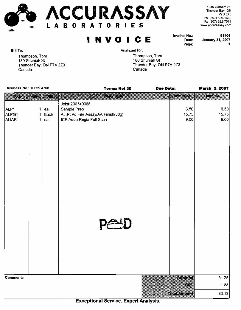
9 hrs prospecting @ $ 22.50 per hr + 300 kms @ 0.35 per km. And $ 33.10 for the Jan. 23 /07 analysis of the sample
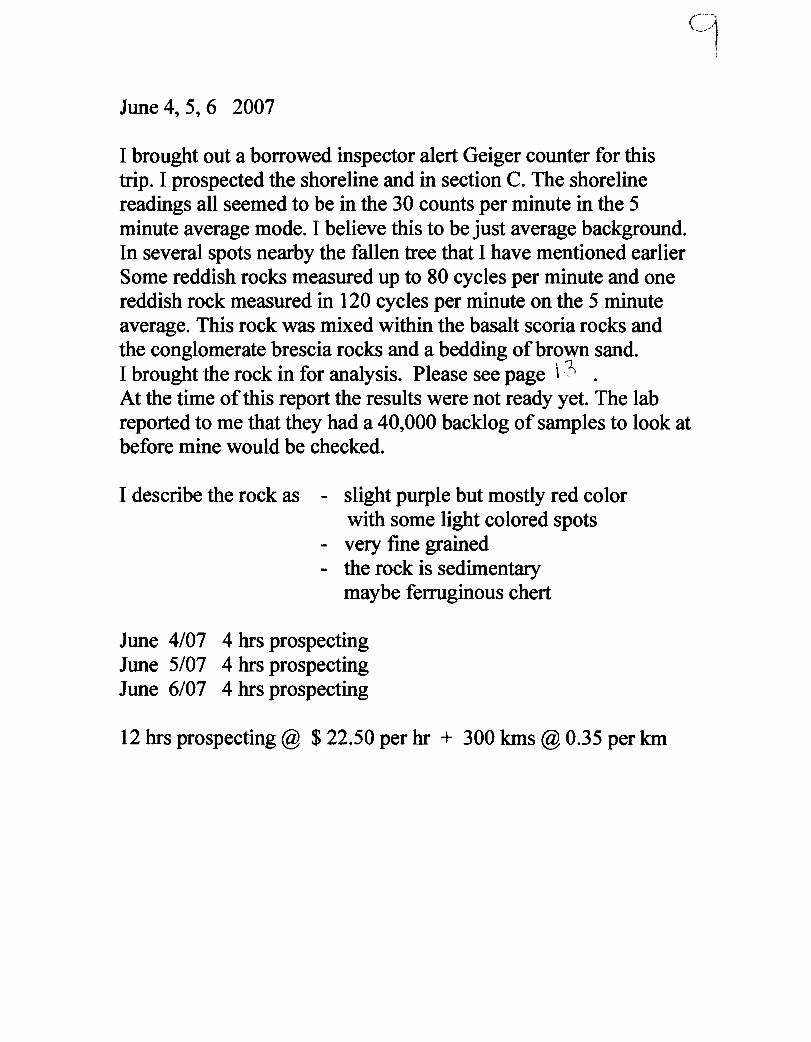
June 4, 5, 6 2007
I brought out a borrowed inspector alert Geiger counter for this trip. I prospected the shoreline and in section C. The shoreline readings all seemed to be in the 30 counts per minute in the 5 minute average mode. I believe this to be just average background. In several spots nearby the fallen tree that I have mentioned earlier Some reddish rocks measured up to 80 cycles per minute and one reddish rock measured in 120 cycles per minute on the 5 minute average. This rock was mixed within the basalt scoria rocks and the conglomerate brescia rocks and a bedding of brown sand. I brought the rock in for analysis. Please see page i,~ . At the time of this report the results were not ready yet. The lab reported to me that they had a 40,000 backlog of samples to look at before mine would be checked.
I describe the rock as - slight purple but mostly red color with some light colored spots
- very fine grained - the rock is sedimentary
maybe ferruginous chert
June 4/07 4 hrs prospecting June 5/07 4 hrs prospecting June 6/07 4 hrs prospecting
12 hrs prospecting @ $ 22.50 per hr + 300 kms @ 0.35 per km
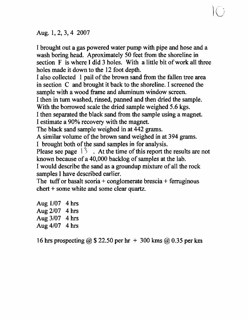
Aug. 1,2,3,4 2007
I brought out a gas powered water pump with pipe and hose and a wash boring head. Aproximately 50 feet from the shoreline in section F is where I did 3 holes. With a little bit of work all three holes made it down to the 12 foot depth. I also collected 1 pail of the brown sand from the fallen tree area in section C and brought it back to the shoreline. I screened the sample with a wood frame and aluminum window screen. I then in turn washed, rinsed, panned and then dried the sample. With the borrowed scale the dried sample weighed 5.6 kgs. I then separated the black sand from the sample using a magnet. I estimate a 90% recovery with the magnet. The black sand sample weighed in at 442 grams. A similar volume of the brown sand weighed in at 394 grams. I brought both of the sand samples in for analysis. Please see page \ ') . At the time of this report the results are not known because of a 40,000 backlog of samples at the lab. I would describe the sand as a groundup mixture of all the rock samples I have described earlier. The tuff or basalt scoria + conglomerate brescia + ferruginous chert + some white and some clear quartz.
Aug 1/07 4 hrs Aug 2/07 4 hrs Aug 3/07 4 hrs Aug 4/07 4 hrs
16 hrs prospecting @ $ 22.50 per hr + 300 kms @ 0.35 per km
)C)

At::.:: LABORATORIES
1046 Gorham Street Thunder Bay, ON Canada P7B 5X5
Tel: (807) 626·1630 Fax: (807) 622·7571
www.accurassay.com [email protected]
Certificate of Analysis Tuesday, January 23, 2007
Thompson, Tom 180 Shuniah St. Thunder Bay, ON, CA P7A2Z3 Ph#: (807) 344·0975 FaX#: Email [email protected]
Accurassay #
3512
3513 Check
"-.._""
Client Id
Dry Creek 2
Dry Creek 2
Date Received: 16-Jan-07 Date Completed: 23-Jan-07
Job # 200740068 Reference:
Au
ppb 10
10
Sample #: 1 Rock
Pt
ppb <15
<15
Pd
ppb <10
<)0
Rh
ppb
PROCEDU~ ____ Page I of I • ., ~e results Included on this report relate only to the items tested c.rtlfie4~ Th. C_" .. of." .... """,Id ,ot '" rep"",_ ~~~ L, "L1 .......... _,
Oerek mlaniuk H.Bsc., Laboratory Manager approval ofthe laboratory AL907-0447·0112312007 10:47 AM
1 I
ACCURASS/\ LABORATOR E S
INVOICE Invoice No.:
Bill To: Analyzed for:
Thompson, Tom 180 Shuniah St Thunder Bay, ON P7 A 2Z3 Canada
Business No.: 100294768
ments
ea. Each ea
Terms: Net 30
Sample Prep AU,Pt,Pd Fire Assay/AA Finish(30g) ICP Aqua Regia Full Scan
Thompson, Tom 180 Shuniah St Thunder Bay, ON P7 A 2Z3 Canada
Due Date:
Date: Page:
6.50 15.75 9.00
1046 Gorham St. Thunder Bay, ON
P7B 5X5 Ph: (807) 626-1630 Fx: (807) 622-7571
www.accurassay.com
91406 January 31, 2007
1
March 2, 2007
6.50 15.75 9.00
31.25
1.88
33.13

~ ~~~~~~~AY - -
Thompson, Tom Date Created: 07-01-2802:24 PM Job Number: 200740068 Date Recieved: 1/16/2007 Number of Samples: 1 Type of Sample: Rock Date Completed: 112312007 Project ID:
Accur. # Client Tag Ag
ppm
AI
%
As ppm
B Ba Be Bi
ppm ppm ppm ppm
Ca
%
Tel: (8J7)62&163) FalC (ron 622-7571
Cd Co
ppm ppm
Cr ppm
3512 Dry Creek 2 <1 2.68 14 110 21 <1 10 >10.00 <4 8 7
48 56 3513 Dry Creek 2 <1 2.79 9 113 22 <1 21 >10.00 <4
., The results included on this report relate only to the items tested
., This Certificate of Analysis should not be reproduced except in full, without the written approval of the laboratory.' .
*The methods used for these analysis are not accredited under ISOIIEC 17025
Cu
ppm
Fe %
K
%
Li
ppm
Mg
%
Mn
ppm
Mo ppm
Na %
Ni ppm
p
ppm
Pb Sb Se
ppm ppm ppm
Si
% Sn Sr Ti TI V
ppm ppm ppm ppm ppm
W Y Zn
ppm ppm ppm
10 1.29 0.09 2 5.26 128 36 0.83 15 306 302
4
2
<5 <5 0.16 <10 66 746 2 20 <10 15 11
5 9 1.33 0.09 2 5.36 130 35 0.86 13 <5 <5 0.17 <10 67 776 <1 21 <10 16
ACCURASSAY LABORATORIES
1046 Gorham Street 101 Magill St., Unit #300, 349 Old Airport Rd., 443 J.R. Smallwood Blvd .. PO Box 791.
Thunder Bay. ON Lively, ON Yellowknife, NT Gambo South, NL
...... ~-.~.~~-....
Canada PIB 5X5 Canada P3Y lK6 Canada X1A 3T4 Canada AOa lTO
'-J~-.. ", .~---
lhOY,-, fS .x..::r.~
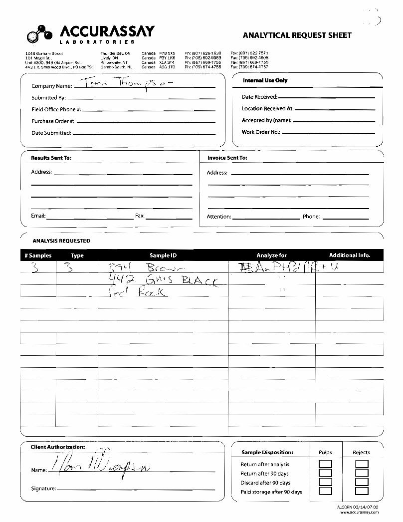
Company Name:
Submitted By:
Field Office Phone #:
Purchase Order #:
Date Submitted:
( Results Sent To:
Address:
Email: Fax:
REQUESTED
ANALYTICAL REQUEST SHEET
Ph: (807) 626-1630 Ph: (705) 692-9963 Ph: (867) 669-7755 Ph: (709) 674·4755
"'\
Fax: (807) 622-7571 Fax: (705) 692-4508 Fax: (867) 669-7755 Fax: (709) 674-4757
Intemal Use Only
I Date Received:
Location Received At:
Accepted by (name):
Work Order No.:
\.
Invoice Sent To:
Address:
I
Attention:
! ,
Sample Disposition:
Return after analysis
Return after 90 days
Discard after 90 days
Paid storage after 90 days
./
Phone:
Pulps Rejects
D D D D D D D D
~------~------~ ALCCRN 03/14/07-02
www.accurassay.com
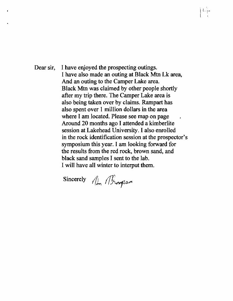
Dear sir, I have enjoyed the prospecting outings. I have also made an outing at Black Mtn Lk area, And an outing to the Camper Lake area. Black Mtn was claimed by other people shortly after my trip there. The Camper Lake area is also being taken over by claims. Rampart has also spent over 1 million dollars in the area where I am located. Please see map on page Around 20 months ago I attended a kimberlite session at Lakehead University. I also enrolled in the rock identification session at the prospector's symposium this year. I am looking forward for the results from the red rock, brown sand, and black sand samples I sent to the lab. I will have all winter to interput them.
Sincerely /().. ~
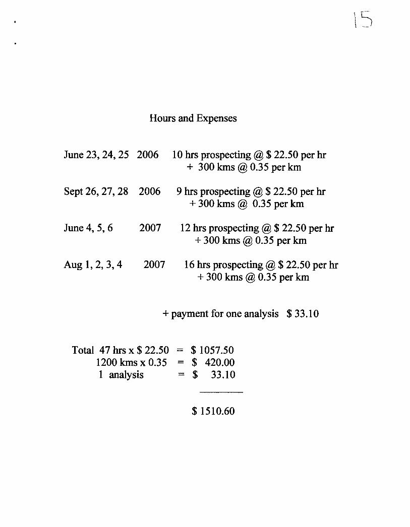
Hours and Expenses
June 23, 24, 25 2006 10 hrs prospecting @ $ 22.50 per hr + 300 lons @ 0.35 per km
Sept 26, 27, 28 2006 9 hrs prospecting @ $ 22.50 per hr + 300 lons @ 0.35 per km
June 4,5,6 2007 12 hrs prospecting @ $ 22.50 per hr + 300 lons @ 0.35 per lon
Aug 1,2,3,4 2007 16 hrs prospecting @ $ 22.50 per hr + 300 lons @ 0.35 per lon
+ payment for one analysis $ 33.10
Total 47 hrs x $ 22.50 = $ 1057.50 1200 kms x 0.35 - $ 420.00 1 analysis - $ 33.10
$ 1510.60
\