proposed highway project vanderslice road designresources.mohavecounty.us/file/public...
TRANSCRIPT
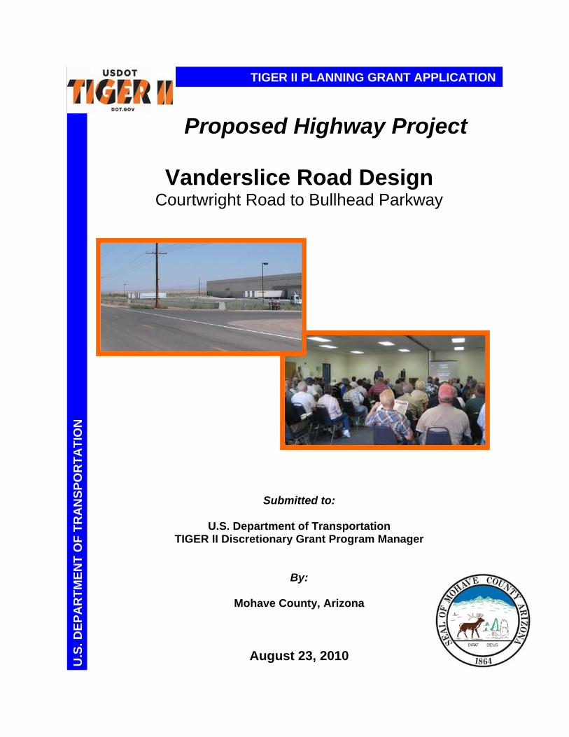
Proposed Highway Project
Vanderslice Road Design
Courtwright Road to Bullhead Parkway
Submitted to:
U.S. Department of Transportation TIGER II Discretionary Grant Program Manager
By:
Mohave County, Arizona
August 23, 2010
TIGER II PLANNING GRANT APPLICATIONU
.S. D
EP
AR
TM
EN
T O
F T
RA
NS
PO
RT
AT
ION

Page 2 of 18
APPLICATION MCPW-2153 1. What type of project is proposed? Highway project 2. Location of the project
Mohave Valley CDP in Western Mohave County, Arizona, which represents an economically distressed area
3. Is the project in an urban or rural
area? Rural area situated near Urban Clusters of Bullhead City, Arizona (north) and Needles, California (southwest)
4. Amount in dollars of Grant Funds the applicant is seeking?
$1,200,00.00 While the 20 percent matching requirement does not apply to projects in rural areas, Mohave County, in order to increase the project’s competitiveness, has allocated 20 percent, or $300,000.00, of the total project cost, for use in this project.
5. DUNS number 077531937
6. Current registration in the Central Contractor Registration? Current active status in Central Contractor Registration; Valid until July 12,2011
Primary Point of Contact Steven P. Latoski, P.E., PTOE Director Mohave County Public Works P.O. Box 7000 3675 E. Andy Devine Ave., Ste. C Kingman, Arizona 86402-7000 Phone: (928) 757-0910 Fax: (928) 757-0921 E-mail: [email protected]
CONTACT INFORMATION
PROJECT PROPOSAL INFORMATION
Page 3 of 18
Overview and Map
Mohave County, Arizona presents this application for the Department of Transportation’s National Infrastructure Investment Grants, TIGER II Planning Grant funding for the design of new construction of Vanderslice Road bisecting the Mohave Valley, Arizona CDP and Fort Mojave Indian Reservation. This Project initiates a new and continuous north/south arterial road to meet established needs such as providing unrestricted private and Tribal lands access and economic development opportunity, improving traffic mobility, and enhancing the health, safety, and well being of the traveling public. The Vanderslice Road Construction Project represents one of 65 recommended strategic highway projects, one of four new roadway corridors, and the sole local road facility proposed in the June 2008 Arizona Department of Transportation (ADOT) Statewide Transportation Investment Strategy program planned for any future new transportation finance mechanism. Mohave County completed and adopted a Design Concept Report and preliminary plans in November 2008 for an overall 14-mile Vanderslice Road alignment from Courtwright Road north to the multi-lane Bullhead Parkway in Bullhead City, Arizona and serving traffic to/from the gaming resort destination of Laughlin, Nevada, which features over 10,000 hotel rooms. The proposed Project involves the design of Vanderslice Road from Courtwright Road to Bullhead Parkway traversing roughly 14 miles of a predominately rural area of Mohave Valley ripe for future economic development. Table 1 presents specific characteristics of the Project proposal.
Table 1 – Project Summary CHARACTERISTIC DEVELOPMENT MILESTONE
Cross section 42-foot traveled way consisting of one thru lane in each
direction and center paved median for left-turns 8-foot shoulders 84-foot right-of-way section
Design criteria Minor arterial functional class 2030 design year and design Level of Service C AASHTO design criteria for 45 mph design speed
Project elements Widen and reconstruct existing 2-lane road from
Courtwright Road to Laguna Road (2 miles), and from Camp Mohave Road to Sterling Road (1 mile).
Construct new road on unimproved section line alignment from Laguna Road to Camp Mohave Road (9 miles), and from Sterling Road to Bullhead Parkway ( 2 miles).
Design Concept Report and Preliminary Plans (http://www.co.mohave.az.us/ContentPage.aspx?id=128&cid=235&page=2&rid=183)
Arizona Statewide Transportation Planning Framework – see Chapter 6 of Full Report. Full Report (http://www.bqaz.gov/StatewideTransportationPlanningFramework.asp)
The Vanderslice Road alignment lies 2 miles east and parallel to the existing Arizona Route 95 through greater Mohave Valley. This Project provides (1) the first, continuous alternate route to Arizona Route 95 in the area and (2) strategic access through the heart of Mohave Valley and adjoining Fort Mojave Indian Tribal lands. The southern Project end at Courtwright Road is situated just 5 miles from Interstate 40 providing access to the CANAMEX Corridor, including Las Vegas (121 miles) and Phoenix (262 miles), as well as to California (Los Angeles = 266 miles). Figure 1 shows regional transportation connections relative to the Project location and Vanderslice Road future extension.
PROJECT DESCRIPTION
Page 4 of 18
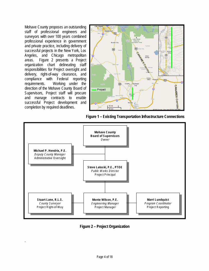
Mohave County proposes an outstanding staff of professional engineers and surveyors with over 100 years combined professional experience in government and private practice, including delivery of successful projects in the New York, Los Angeles, and Chicago metropolitan areas. Figure 2 presents a Project organization chart delineating staff responsibilities for Project oversight and delivery, right-of-way clearance, and compliance with Federal reporting requirements. Working under the direction of the Mohave County Board of Supervisors, Project staff will procure and manage contracts to enable successful Project development and completion by required deadlines.
Figure 1 – Existing Transportation Infrastructure Connections
Figure 2 – Project Organization
.
Mohave CountyBoard of Supervisors
Owner
Mohave CountyBoard of Supervisors
Owner
Steve Latoski, P.E., PTOEPublic W orks D irector
Project Principal
Steve Latoski, P.E., PTOEPublic W orks D irector
Project Principal
Michael P. Hendrix, P.E.Deputy County ManagerAdministrative Oversight
Michael P. Hendrix, P.E.Deputy County ManagerAdministrative Oversight
Monte W ilson, P.E.Engineering Manager
Project Manager
Monte W ilson, P.E.Engineering Manager
Project Manager
Marri LundquistProgram Coordinator
Project Reporting
Marri LundquistProgram Coordinator
Project Reporting
Stuart Lane, R .L.S.County Surveyor
Project R ight-of-W ay
Stuart Lane, R.L.S.County Surveyor
Project R ight-of-W ay

Page 5 of 18
Need Mohave County and Mohave Valley CDP both qualify as an economically distressed area as defined by Section 301 of the Public Works and Economic Development Act of 1965, as amended. These areas meet the income criterion whereby each area has a per capita income of 80 percent or less of the national average referencing the most recent Federal data available. Based on 2000 Census data, Mohave Valley lags the County in per capita income at 75 percent versus 78 percent, respectively, of the national average. Mohave County’s population growth has outpaced the State over the past several decades, and the Mohave Valley area has witnessed rapid growth in recent years due to extensive new residential development. Table 2 lists socioeconomic data applicable to the Project area.
Table 2 – Project Area Socioeconomic Data MOHAVE COUNTY CHARACTERISTIC MOHAVE VALLEY CDP CHARACTERISTIC
Population 1990 = 93,497 2000 = 155,032 2008 = 196,281
Land area = 13,311 square miles Per capita income (2007) = $20,889 (U.S. = $26,178) Per capita income (1999) = $16,788 (U.S. = $21,587) Top industry employers (2002): retail, health care, and
accommodation and food services
Population 1990 = 6,962 2000 = 13,694
Land area = 45.4 square miles Per capita income (1999) = $16,287 (U.S. = $21,587) Adjacent Native American Tribal Reservations
Fort Mojave Indian Tribe Mohave Valley Chamber of Commerce
Table 3 identifies considerations driving the present need to develop Vanderslice Road as demonstrated by Mohave County’s commitment to completing a Design Concept Report and preliminary plans for the Project. The setting and characteristics of this Project will increase economic growth to Mohave Valley by exploiting access to markets throughout the Southwestern United States. This occurred with the 2006 construction of a two-lane, paved section of Vanderslice Road from Courtwright Road to Laguna Road (2 miles) followed by an industrial park and warehousing development adjacent Vanderslice Road on 22 acres.
Table 3 – Considerations Influencing Project Need CONSIDERATION
Mohave County transportation infrastructure development has lagged area growth. The Project area’s close proximity to high-capacity transportation connections prove advantageous for a broad array of light
industry and manufacturing uses with access to Bullhead City, Mohave Valley, and Needles work force population and complementing current leading industries in the area.
The Fort Mojave Indian Tribe stewards over 3,500 acres of undeveloped or agricultural land sections adjoining the Project.
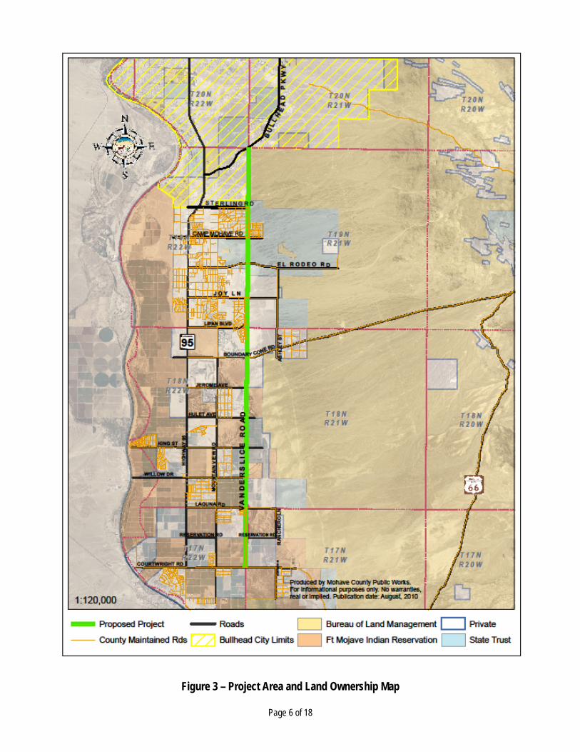
Figure 3 shows land ownership and highlights Mohave County maintained roads in the vicinity of the Project, situated two miles east of ADOT operated Arizona Route 95. Figure 4 presents a photo log of existing conditions on the Project alignment for Vanderslice Road. Current Mohave Valley residents recognize Project need as well. During Design Concept Report development, Mohave County commissioned a public opinion poll in 2007 to determine public perception/support and need for mobility improvements. A random telephonic survey of 580 adults in the Mohave Valley area yielded 84 percent voicing support for another road to Arizona Route 95.
Page 6 of 18
Figure 3 – Project Area and Land Ownership Map

Page 7 of 18
Figure 4 – Project Area Photo Log
NORTHBOUND INTERSECTION SOUTHBOUND
Sterling Road
(Mile 12)
Camp Mohave Road
(Mile 11)
El Rodeo Road
(Mile 10)
Boundary Cone
Road (Mile 7)
Jerome Avenue (Mile 6)
Hulet Avenue (Mile 5)
King Street
(Mile 4)
Willow Drive
(Mile 3)
Laguna Road
(Mile 2)
Reservation Road
(Mile 1)
Courtwright Road
(Mile 0)

Page 8 of 18
Transportation Challenges Vanderslice Road will provide a minor arterial route secondary to Arizona Route 95 and designed to service trips destined to/from Mohave Valley homes and other trip generators. It will improve safety and operations on Arizona Route 95 through local traffic diversion to direct route(s) of travel. In turn, Arizona Route 95 may realize reduced intersection turning maneuvers contributing to crash likelihood and impacting through movements. Table 4 summarizes Project transportation benefits.
Table 4 – Project Transportation Benefits BENEFIT
Improve traffic circulation for area residents and emergency service providers. Provide an alternate, continuous north/south route for traffic destined to/from greater Mohave Valley. Improve safety and operations on Arizona Route 95 through reduced use for local trips. Improve regional traffic flow through greater Mohave Valley. Enhance the health, safety, and welfare of the traveling public.
The new development enables implementation of access management controls as recommended in the approved Design Concept Report for driveway access and intersection clearance. Performance Measures This Project promises significant positive impact to the region. It will provide long-term economic benefits to an economically disadvantaged area. Moreover, it will improve quality of life for local users and travel efficiency benefiting regional, through traffic. Table 5 lists performance measures qualifying the Project need.
Table 5 – Project Performance Measures BENEFIT
Develop 14 miles of continuous roadway to expand Mohave County Road System network. Intersect and connect four current Mohave County maintained east/west arterial section line roads. Provide capacity to serve over 13,000 vehicles per day under Level of Service C operations. Reduce parallel Arizona Route 95 daily traffic volume by as much as 15 percent relative to no-build condition in design year.
Mohave County represents the Project sponsor and proposed TIGER II Planning Grant recipient. A conglomerate of local, state, tribal, and Federal entities comprised the Technical Advisory Committee employed to provide institutional direction in planning the road alignment and facility design recommendations presented in the Vanderslice Road Design Concept Report. Stakeholders collectively represented transportation, environmental, and land trust interests and included the Arizona Department of Transportation, Arizona State Land Department, City of Bullhead City, Bureau of Land Management, and Fort Mojave Indian Tribe.
PROJECT PARTIES
Page 9 of 18
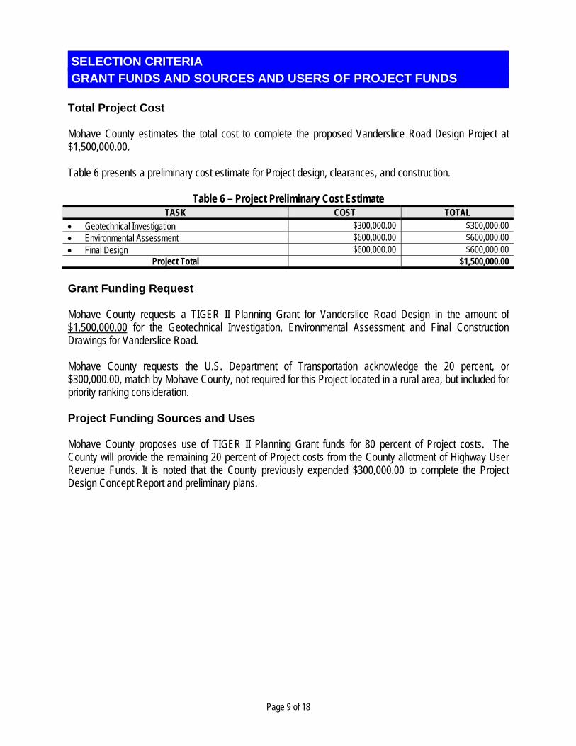
Total Project Cost Mohave County estimates the total cost to complete the proposed Vanderslice Road Design Project at $1,500,000.00. Table 6 presents a preliminary cost estimate for Project design, clearances, and construction.
Table 6 – Project Preliminary Cost Estimate TASK COST TOTAL
Geotechnical Investigation $300,000.00 $300,000.00 Environmental Assessment $600,000.00 $600,000.00 Final Design $600,000.00 $600,000.00
Project Total $1,500,000.00
Grant Funding Request Mohave County requests a TIGER II Planning Grant for Vanderslice Road Design in the amount of $1,500,000.00 for the Geotechnical Investigation, Environmental Assessment and Final Construction Drawings for Vanderslice Road. Mohave County requests the U.S. Department of Transportation acknowledge the 20 percent, or $300,000.00, match by Mohave County, not required for this Project located in a rural area, but included for priority ranking consideration. Project Funding Sources and Uses Mohave County proposes use of TIGER II Planning Grant funds for 80 percent of Project costs. The County will provide the remaining 20 percent of Project costs from the County allotment of Highway User Revenue Funds. It is noted that the County previously expended $300,000.00 to complete the Project Design Concept Report and preliminary plans.
GRANT FUNDS AND SOURCES AND USERS OF PROJECT FUNDS SELECTION CRITERIA

Page 10 of 18
Long-Term Outcomes State of Good Repair Mohave County maintains a fragmented road network through greater Mohave Valley. Currently, between the 14-mile Project area stretch from Courtwright Road to Bullhead Parkway, the County maintains only 3 miles of road on the north/south section line arterial alignments inclusive of Vanderslice Road. This stymies land access and economic development in the area as well as constricts the regional transportation network to existing Arizona Route 95, between Needles, CA and Bullhead City, AZ, serving both local and regional through traffic. Table 7 lists Project benefits in the context of improving condition of existing transportation facilities.
Table 7 – Project Benefits Toward State of Good Repair BENEFIT
Develop 11 miles of new paved roadway on existing non-maintained or otherwise non-traversable alignment to enable future economic growth and stability on primarily undeveloped private and Tribal lands adjoining the alignment.
Redevelop and widen the 3 miles of existing roadway on the Project alignment to extend (1) design operations service life to Year 2030 and (2) pavement service life while accounting for future heavy vehicle traffic.
Implement access management controls to sustain new facility performance and safety given minimal existing development and established points-of-access.
Develop new, continuous arterial facility consistent with (1) ADOT Statewide Transportation Investment Strategy recommendations, citing Vanderslice Road as one of four strategic new roadway corridors statewide and (2) Mohave County 5-Year Capital Improvement Program recommendations.
Incorporate new facility into Mohave County Road Maintenance System, which enables performance of preventative and service life sustaining maintenance activities funded through the County’s primary and continuous source of revenue for road maintenance and improvement through the Arizona Highway User Revenue Fund (HURF).
Obtain increased HURF distribution for road maintenance and improvement through the construction and acceptance of additional centerline miles of paved roads into the Mohave County Road Maintenance System.
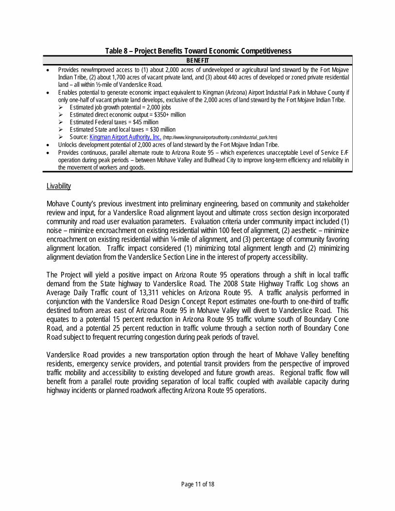
Economic Competitiveness The development of Vanderslice Road represents the single, primary investment enabling new investments of private sector and Tribal commercial and industrial development within a largely inaccessible corridor flanked by undeveloped and agricultural lands. The very close proximity of Interstate 40 and its access to Southern California and CANAMEX Corridor provides tremendous momentum for this Economically Distressed Area to realize an explosion of new full-time job growth in a broad range professional, technician, and general laborer categories. Figure 5 shows direct evidence of this growth potential occurred with the construction of an approximate $12 million warehouse on a 22-acre site after Mohave County construction of a paved 2-lane section of Vanderslice Road between Courtwright Road and Laguna Road (2 miles) in 2006. An additional 128 acres abuts the warehouse development for future industrial park expansion. Table 8 presents Project benefits in the context of improving economic competitiveness.
Figure 5 – Vanderslice Road Warehouse
Page 11 of 18
Table 8 – Project Benefits Toward Economic Competitiveness BENEFIT
Provides new/improved access to (1) about 2,000 acres of undeveloped or agricultural land steward by the Fort Mojave Indian Tribe, (2) about 1,700 acres of vacant private land, and (3) about 440 acres of developed or zoned private residential land – all within ½-mile of Vanderslice Road.
Enables potential to generate economic impact equivalent to Kingman (Arizona) Airport Industrial Park in Mohave County if only one-half of vacant private land develops, exclusive of the 2,000 acres of land steward by the Fort Mojave Indian Tribe. Estimated job growth potential = 2,000 jobs Estimated direct economic output = $350+ million Estimated Federal taxes = $45 million Estimated State and local taxes = $30 million Source: Kingman Airport Authority, Inc. (http://www.kingmanairportauthority.com/industrial_park.htm)
Unlocks development potential of 2,000 acres of land steward by the Fort Mojave Indian Tribe. Provides continuous, parallel alternate route to Arizona Route 95 – which experiences unacceptable Level of Service E/F
operation during peak periods – between Mohave Valley and Bullhead City to improve long-term efficiency and reliability in the movement of workers and goods.
Livability Mohave County’s previous investment into preliminary engineering, based on community and stakeholder review and input, for a Vanderslice Road alignment layout and ultimate cross section design incorporated community and road user evaluation parameters. Evaluation criteria under community impact included (1) noise – minimize encroachment on existing residential within 100 feet of alignment, (2) aesthetic – minimize encroachment on existing residential within ¼-mile of alignment, and (3) percentage of community favoring alignment location. Traffic impact considered (1) minimizing total alignment length and (2) minimizing alignment deviation from the Vanderslice Section Line in the interest of property accessibility. The Project will yield a positive impact on Arizona Route 95 operations through a shift in local traffic demand from the State highway to Vanderslice Road. The 2008 State Highway Traffic Log shows an Average Daily Traffic count of 13,311 vehicles on Arizona Route 95. A traffic analysis performed in conjunction with the Vanderslice Road Design Concept Report estimates one-fourth to one-third of traffic destined to/from areas east of Arizona Route 95 in Mohave Valley will divert to Vanderslice Road. This equates to a potential 15 percent reduction in Arizona Route 95 traffic volume south of Boundary Cone Road, and a potential 25 percent reduction in traffic volume through a section north of Boundary Cone Road subject to frequent recurring congestion during peak periods of travel. Vanderslice Road provides a new transportation option through the heart of Mohave Valley benefiting residents, emergency service providers, and potential transit providers from the perspective of improved traffic mobility and accessibility to existing developed and future growth areas. Regional traffic flow will benefit from a parallel route providing separation of local traffic coupled with available capacity during highway incidents or planned roadwork affecting Arizona Route 95 operations.
Page 12 of 18
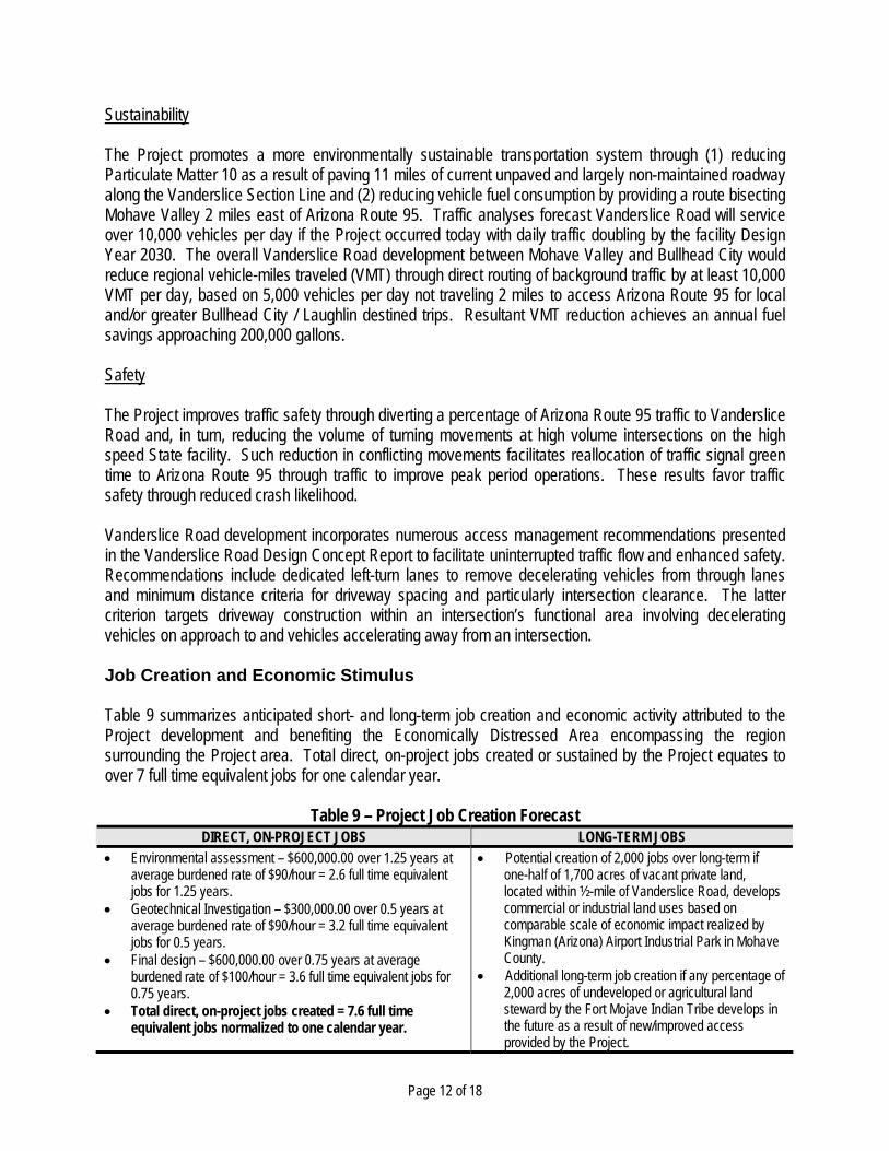
Sustainability The Project promotes a more environmentally sustainable transportation system through (1) reducing Particulate Matter 10 as a result of paving 11 miles of current unpaved and largely non-maintained roadway along the Vanderslice Section Line and (2) reducing vehicle fuel consumption by providing a route bisecting Mohave Valley 2 miles east of Arizona Route 95. Traffic analyses forecast Vanderslice Road will service over 10,000 vehicles per day if the Project occurred today with daily traffic doubling by the facility Design Year 2030. The overall Vanderslice Road development between Mohave Valley and Bullhead City would reduce regional vehicle-miles traveled (VMT) through direct routing of background traffic by at least 10,000 VMT per day, based on 5,000 vehicles per day not traveling 2 miles to access Arizona Route 95 for local and/or greater Bullhead City / Laughlin destined trips. Resultant VMT reduction achieves an annual fuel savings approaching 200,000 gallons. Safety The Project improves traffic safety through diverting a percentage of Arizona Route 95 traffic to Vanderslice Road and, in turn, reducing the volume of turning movements at high volume intersections on the high speed State facility. Such reduction in conflicting movements facilitates reallocation of traffic signal green time to Arizona Route 95 through traffic to improve peak period operations. These results favor traffic safety through reduced crash likelihood. Vanderslice Road development incorporates numerous access management recommendations presented in the Vanderslice Road Design Concept Report to facilitate uninterrupted traffic flow and enhanced safety. Recommendations include dedicated left-turn lanes to remove decelerating vehicles from through lanes and minimum distance criteria for driveway spacing and particularly intersection clearance. The latter criterion targets driveway construction within an intersection’s functional area involving decelerating vehicles on approach to and vehicles accelerating away from an intersection. Job Creation and Economic Stimulus Table 9 summarizes anticipated short- and long-term job creation and economic activity attributed to the Project development and benefiting the Economically Distressed Area encompassing the region surrounding the Project area. Total direct, on-project jobs created or sustained by the Project equates to over 7 full time equivalent jobs for one calendar year.
Table 9 – Project Job Creation Forecast DIRECT, ON-PROJECT JOBS LONG-TERM JOBS
Environmental assessment – $600,000.00 over 1.25 years at average burdened rate of $90/hour = 2.6 full time equivalent jobs for 1.25 years.
Geotechnical Investigation – $300,000.00 over 0.5 years at average burdened rate of $90/hour = 3.2 full time equivalent jobs for 0.5 years.
Final design – $600,000.00 over 0.75 years at average burdened rate of $100/hour = 3.6 full time equivalent jobs for 0.75 years.
Total direct, on-project jobs created = 7.6 full time equivalent jobs normalized to one calendar year.
Potential creation of 2,000 jobs over long-term if one-half of 1,700 acres of vacant private land, located within ½-mile of Vanderslice Road, develops commercial or industrial land uses based on comparable scale of economic impact realized by Kingman (Arizona) Airport Industrial Park in Mohave County.
Additional long-term job creation if any percentage of 2,000 acres of undeveloped or agricultural land steward by the Fort Mojave Indian Tribe develops in the future as a result of new/improved access provided by the Project.
Page 13 of 18
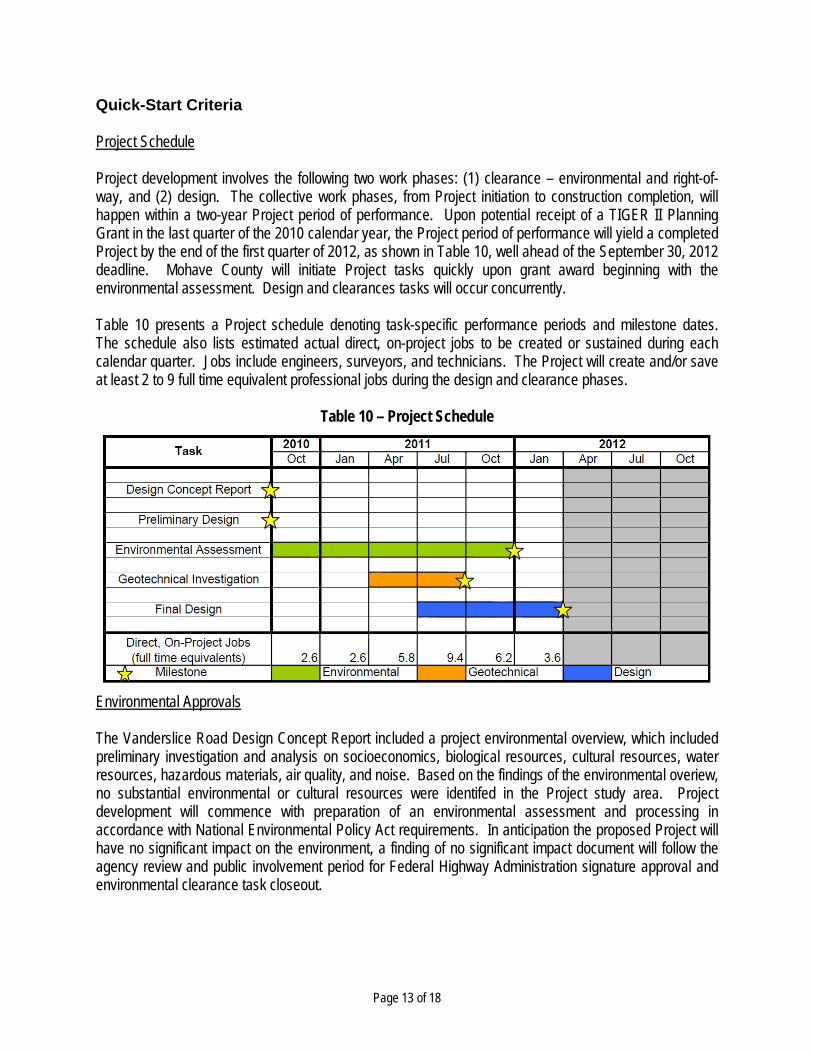
Quick-Start Criteria Project Schedule Project development involves the following two work phases: (1) clearance – environmental and right-of-way, and (2) design. The collective work phases, from Project initiation to construction completion, will happen within a two-year Project period of performance. Upon potential receipt of a TIGER II Planning Grant in the last quarter of the 2010 calendar year, the Project period of performance will yield a completed Project by the end of the first quarter of 2012, as shown in Table 10, well ahead of the September 30, 2012 deadline. Mohave County will initiate Project tasks quickly upon grant award beginning with the environmental assessment. Design and clearances tasks will occur concurrently. Table 10 presents a Project schedule denoting task-specific performance periods and milestone dates. The schedule also lists estimated actual direct, on-project jobs to be created or sustained during each calendar quarter. Jobs include engineers, surveyors, and technicians. The Project will create and/or save at least 2 to 9 full time equivalent professional jobs during the design and clearance phases.
Table 10 – Project Schedule
Environmental Approvals The Vanderslice Road Design Concept Report included a project environmental overview, which included preliminary investigation and analysis on socioeconomics, biological resources, cultural resources, water resources, hazardous materials, air quality, and noise. Based on the findings of the environmental overiew, no substantial environmental or cultural resources were identifed in the Project study area. Project development will commence with preparation of an environmental assessment and processing in accordance with National Environmental Policy Act requirements. In anticipation the proposed Project will have no significant impact on the environment, a finding of no significant impact document will follow the agency review and public involvement period for Federal Highway Administration signature approval and environmental clearance task closeout.
Page 14 of 18
Legislative Approvals Appendix A contains a Resolution of Support, adopted by the Mohave County Board of Supervisors, for the Vanderslice Road Design Project, TIGER II Planning Grant application submittal, and 20 percent match committment. In addition, Appendix B presents Letters of Support from all relevant State and local entities, including the (1) Arizona Department of Transportation, (2) City of Bullhead City, and (3) Fort Mojave Indian Tribe. State and Local Planning Mohave County has programmed Vanderslice Road construction in the County’s FY 2010-11 Five-Year Capital Improvement Road Program (CIRP) contingent on identification of a new Project funding source and/or mechanism such as a TIGER II Planning Grant. The Mohave County Board of Supervisors adopted the program on August 2, 2010. Mohave County Public Works maintains an electronic copy of the FY 2010-11 CIRP on the department’s website (http://www.co.mohave.az.us/ContentPage.aspx?id=128&cid=235). Technical Feasibility Mohave County completed a Design Concept Report and preliminary plans which demonstrate the Project’s technical feasibility, and this document will input into the Project design and clearance phases. The Design Concept Report facilitated an engineering study, stakleholder review, and public involvement process to determine the optimal alignment of Vanderslice Road based on the following evaluation parameters: overall cost, ease of implementation, community impact, traffic impact, and environmental impact. Table 11 summarizes technical elements of the Project. Financial Feasibility Mohave County commits to fund 20 percent of the Project cost and 100 percent of Project cost in excess of the TIGER II Planning Grant amount requested in this application. Mohave County maintains a contingency reserve of Arizona Highway User Revenue Funds received for road improvement and maintenance, and the County will access and apply monies contained in this contingency reserve to fund any Project cost overrun.

Page 15 of 18
Table 11 – Project Technical Elements ELEMENT AND CORRESPONDING DESIGN CONCEPT REPORT FINDINGS AND RECOMMENDATIONS
Alignment – follows Vanderslice Section Line due to existing improvement between Courtwright Road and Laguna Road, and between Camp Mohave Road and Sterling Road, existing Mohave County right-of-way, and land ownership/stewardship limited to private entities and the Fort Mojave Indian Tribe.
Design Criteria – establishes AASHTO policies and values for geometric design and MUTCD standards and guidelines for traffic control and applies to typical cross section and preliminary plan design.
Typical Section and Right-of-Way – recommends ultimate typical section through Project limits as shown in Figure 6 and specifies right-of-way width totaling 84 feet.
Traffic – verifies through a corridor level of service analysis that a two/three-lane traveled way provides satisfactory LOS C operations under Design Year 2030 traffic demand.
Environmental – identifies no substantive environmental or cultural resources within the Project study area.
Figure 6 – Vanderslice Road Typical Section Innovation In consideration of pertinent intelligent transportation systems applications to Project planning and Vanderslice Road post-construction operations, changeable message signs (CMS) enable real-time facility operations through dissemination of traveler information on Vanderslice Road or, alternatively, Arizona Route 95 road conditions (e.g., traffic incidents, roadwork, monsoon flooding) influencing access and travel time. Mohave County currently operates 6 permanent, roadside changeable message signs throughout the County, and Project final design will evaluate and incorporate such innovative technology to benefit traffic operations and safety in addition to Mohave County CMS system expansion. Partnership Mohave County contributed all funding toward Vanderslice Road Design Concept Report and preliminary plans preparation, which collectively allow the County to hit the ground running in completing the balance of Project design upon TIGER II Planning Grant award. Mohave County collaborated with all neighboring jurisdictions in developing the Vanderslice Road Design Concept Report. Entities included the Arizona Department of Transportation, Arizona State Land Department, Bureau of Land Management, City of Bullhead City, and Fort Mojave Indian Tribe.
Page 16 of 18
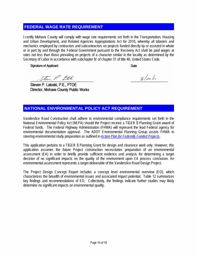
I certify Mohave County will comply with wage rate requirements set forth in the Transportation, Housing and Urban Development, and Related Agencies Appropriations Act for 2010, whereby all laborers and mechanics employed by contractors and subcontractors on projects funded directly by or assisted in whole or in part by and through the Federal Government pursuant to the Recovery Act shall be paid wages at rates not less than those prevailing on projects of a character similar in the locality as determined by the Secretary of Labor in accordance with subchapter IV of chapter 31 of title 40, United States Code.
Vanderslice Road Construction shall adhere to environmental compliance requirements set forth in the National Environmental Policy Act (NEPA) should the Project receive a TIGER II Planning Grant award of Federal funds. The Federal Highway Administration (FHWA) will represent the lead Federal agency for environmental documentation approval. The ADOT Environmental Planning Group assists FHWA in steering environmental study preparation as outlined in Action Plan for Federally Funded Projects. This application pertains to a TIGER II Planning Grant for design and clearance work only. However, this application assumes the future Project construction necessitates preparation of an environmental assessment (EA) in order to briefly provide sufficient evidence and analysis for determining a target decision of no significant impacts on the quality of the environment upon EA process conclusion. An environmental assessment represents a target deliverable of the Vanderslice Road Design Project. The Project Design Concept Report includes a concept level environmental overview (EO), which characterizes the breadth of environmental issues and associated impact potential. Table 12 summarizes key findings and recommendations of EO. Collectively, the findings indicate further studies may likely determine no significant impacts on environmental quality.
FEDERAL WAGE RATE REQUIREMENT
NATIONAL ENVIRONMENTAL POLICY ACT REQUIREMENT

Page 17 of 18
Table 12 – Vanderslice Road Environmental Overview Summary
ELEMENT FINDINGS AND RECOMMENDATIONS Topography, Geology, and
Soils
No significant impacts to the topography or geological resources of the Project area are anticipated as a result of the proposed project.
Erosion control measures will be implemented per a storm water pollution prevention plan (SWPPP) prior to construction.
Farmland In compliance with the Farmland Protection Policy Act, a Farmland Conversion Impact Rating Form should be submitted to NRCS to determine whether any part of the Project site is farmland subject to the Act.
Biological Resources
Extensive clearing will not be required due to the sparseness of the vegetation within the Project area with the exception of areas bordering major washes.
Impacts to plants protected under the Arizona Native Plant Law are expected to be minor as a result of the proposed project.
The Project area does not traverse any rivers or water bodies and therefore no fish or other aquatic-dependant species would be present.
The lack of water decreases the likelihood that migratory bird species would be present within or near the Project area, and impacts are expected to be minimal.
The Project area is not located within any designated critical habitat areas. Construction of the proposed Project will not eliminate wildlife populations or substantially reduce wildlife
population densities or habitat in the region. Natural and Recreational
Areas
No pedestrian, bicycle, or equestrian facilities exist within the Project area. The Bureau of Land Management Lake Havasu Field Office Approved Resource Management Plan identifies
Areas of Critical Environmental Concern (ACEC), which represent special status areas that include, but are not limited to, wildness areas and wilderness study areas, wildlife refuges, areas set aside for historic preservation, and many other BLM “Special Management Areas.” Link to report: http://www.blm.gov/az/st/en/info/nepa/environmental_library/arizona_resource_management/LHFO_ROD_07.html.
The Project is not expected to impact designated ACEC areas. No wild or scenic rivers exist within or adjacent to the Project area. The Colorado River is located west of
the Project area, but it is not designated as a wild or scenic river. Scenic Roads and Parkways
No scenic roadways or parkways exist within the Project area. Historic Route 66 is located more than 10 miles from the Project area.
Cultural Resources
The nearest significant cultural resource area is the Bullhead Bajada Natural and Cultural ACEC located 5 miles north of the Project’s northerly terminus.
There may exist scattered cultural prehistoric archeological sites or Traditional Cultural Properties within various areas of Fort Mojave Tribal Lands.
Floodways and wash waterways link the Black Mountains to the Project area and thereby could deposit cultural resources downstream during an event.
Water Resources
The potential for erosion and sedimentation during construction activities exists due to required vegetation clearing in a few select areas. SWPPP and other plans as required by the Arizona Department of Environmental Quality (ADEQ) will be developed and implemented.
In accordance with Section 402 of the Clean Water Act, if the Project results in one acre or more of ground disturbance, than an Arizona Pollutant Discharge Elimination System construction general permit would be required by ADEQ.
A formal wetland delineation should be performed to further assess the direct impacts to jurisdictional areas under Section 404 of the Clean Water Act.
The Project area encroaches upon the 100-year floodplain and necessitates engineered road drainage systems to ensure no long-term or adverse floodplain impacts.
Hazardous Materials
Due to the land uses established in the Project area, the potential for the presence of hazardous material contamination is low.
Air Quality Project implementation is not expected to result in the Project vicinity being declared a non-attainment area for one or more criteria pollutants.
Noise Impacts Project construction is not expected to conflict with the local noise standards or ordinances. Further analysis of noise impacts resulting from motorized vehicle traffic may be required.
Page 18 of 18
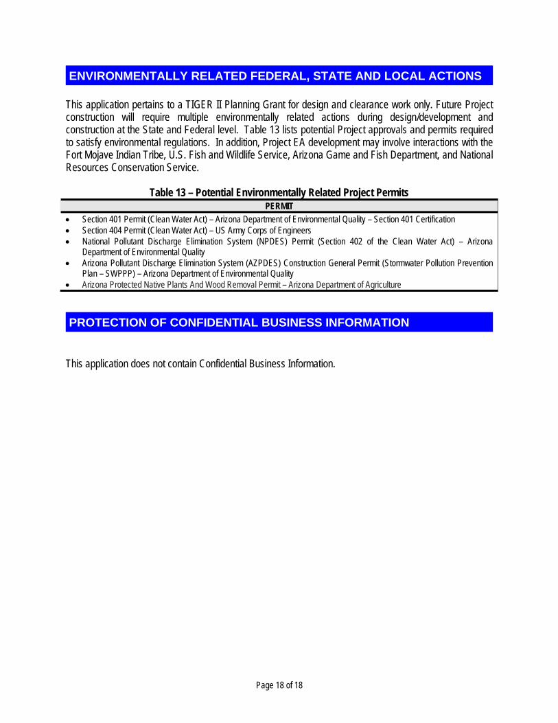
This application pertains to a TIGER II Planning Grant for design and clearance work only. Future Project construction will require multiple environmentally related actions during design/development and construction at the State and Federal level. Table 13 lists potential Project approvals and permits required to satisfy environmental regulations. In addition, Project EA development may involve interactions with the Fort Mojave Indian Tribe, U.S. Fish and Wildlife Service, Arizona Game and Fish Department, and National Resources Conservation Service.
Table 13 – Potential Environmentally Related Project Permits PERMIT
Section 401 Permit (Clean Water Act) – Arizona Department of Environmental Quality – Section 401 Certification Section 404 Permit (Clean Water Act) – US Army Corps of Engineers National Pollutant Discharge Elimination System (NPDES) Permit (Section 402 of the Clean Water Act) – Arizona
Department of Environmental Quality Arizona Pollutant Discharge Elimination System (AZPDES) Construction General Permit (Stormwater Pollution Prevention
Plan – SWPPP) – Arizona Department of Environmental Quality Arizona Protected Native Plants And Wood Removal Permit – Arizona Department of Agriculture
This application does not contain Confidential Business Information.
ENVIRONMENTALLY RELATED FEDERAL, STATE AND LOCAL ACTIONS
PROTECTION OF CONFIDENTIAL BUSINESS INFORMATION
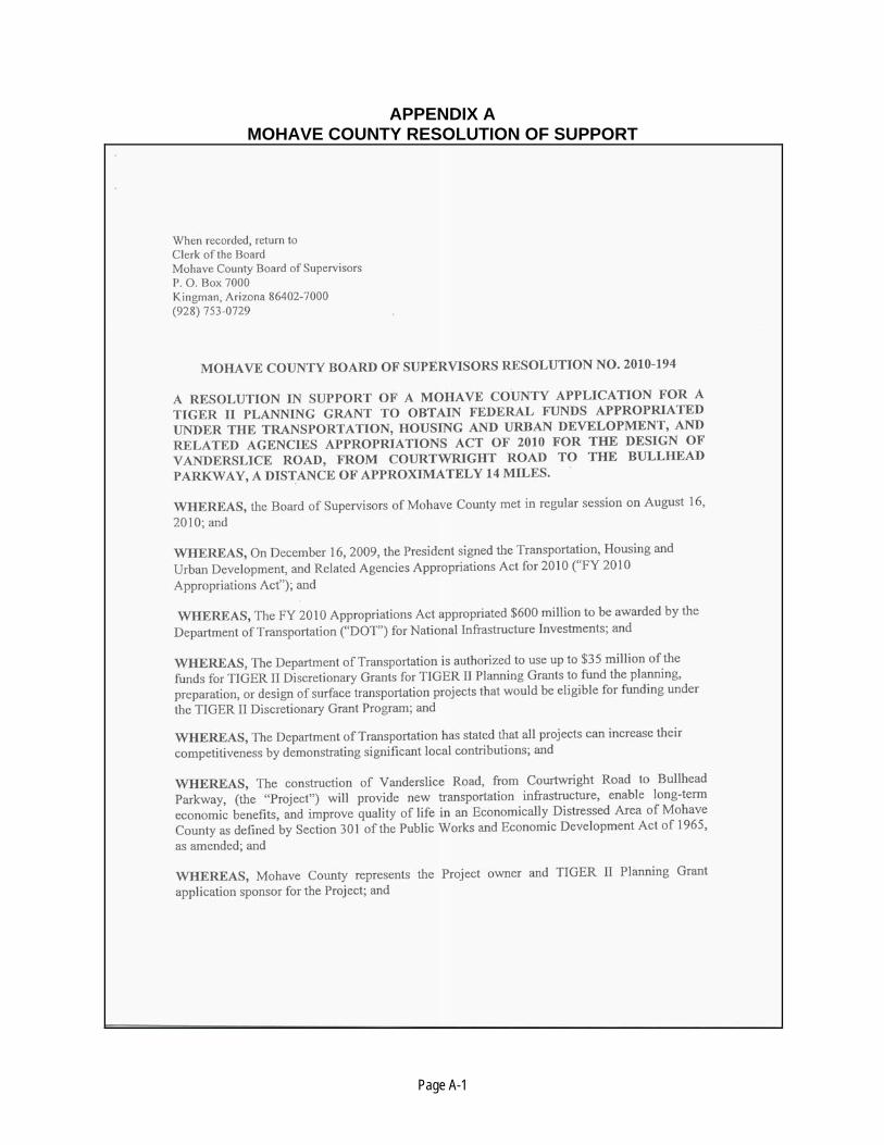
Page A-1
APPENDIX A MOHAVE COUNTY RESOLUTION OF SUPPORT

Page A-2
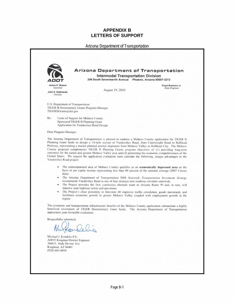
Page B-1
APPENDIX B LETTERS OF SUPPORT
Arizona Department of Transportation

Page B-2
City of Bullhead City, Arizona

Page B-3
Fort Mojave Indian Tribe
Page B-4