probabilistic seismic hazard assessment of india
TRANSCRIPT
Seismological Research Letters Volume 83, Number 1 January/February 2012 135doi: 10.1785/gssrl.83.1.135
Probabilistic Seismic Hazard Assessment of IndiaS. K. Nath and K. K. S. Thingbaijam
S. K. Nath and K. K. S. ThingbaijamIndian Institute of Technology, Kharagpur
Online material: Data !les for seismogenic source zones (poly-gons), smoothed-gridded seismicity models, and hazard curves at 0.2° regular grid spacing over the study region.
INTRODUCTION
Earthquake disasters occur mainly due to the collapse of buildings and structures triggered by ground motions. It is, therefore, important to predict ground-shaking levels in order to determine appropriate building code provisions for earth-quake-resistant design of structures. "is involves extensive analyses and development of appropriate seismological mod-els; namely, seismogenic sources, seismic site conditions, and ground motion predictions. "e hazard products, viz. data and maps, constitute important tools for framing public policies toward land-use planning, building regulations, insurance, and emergency preparedness.
In India, several events during the last 100 years, as listed in Table 1, indicate that even moderate earthquakes (MW < 7.0) can cause signi!cant devastation. On one hand, ongoing urban-ization and unprecedented population growth have consider-ably aggravated the prevailing seismic risk. On the other hand, the available seismic hazard maps covering the entire country are about a decade old. Consequently an updated seismic hazard model for the country is imperative and necessitated by new data, recent !ndings, and methodological improvements. In the pres-ent study, we make a case for new probabilistic seismic hazard analysis (PSHA) of India. "e fundamental studies have been carried out to deliver the hazard components, including seis-mogenic source zonation and seismicity modeling in the Indian subcontinent ("ingbaijam and Nath 2011), assessment of site conditions across the country (Nath, "ingbaijam, Adhikari et al. 2011), and a suitability test for the ground-motion prediction equations in the regional context (Nath and "ingbaijam 2011).
TABLE 1Major Earthquake Casualties during 1900–2008 in India and Adjoining Regions
Event(YYYYMMDD) MW Epicentral Region
Casualty Report*
Deaths Building Damage
19050405 7.8 Kangra, northwest Himalayas 20,000 —19340115 8.1 Bihar-Nepal, central Himalayas 10,700 —19350531 7.7 Quetta, Baluchistan 60,000 —19500815 8.6 Indo-china border† 1,526 —19560721 6.0 Anjar, Gujarat 156 —19671210 6.3 Koyna, South India 177 —19880820 6.8 Udayapur, central north India 700 over 6400019911020 6.8 Uttarkashi, northwest Himalayas 2,000 1800019930929 6.2 Latur, South India 9,500 —19970522 5.8 Jabalpur, central India 39 —19990329 6.6 Chamoli, northwest Himalayas 103‡ extensive20010126 7.7 Bhuj, Gujarat 20,000 33900020041226 9.1 Sumatra, Indonesia 22,7000§ —20051008 7.6 Kashmir, northwest Himalayas 86,000 —
* Approximate figures as reported by United States Geological Survey and National Geophysical Data Center;† Commonly referred to as Assam earthquake; ‡ As reported by India Meteorological Department; § 10,749 deaths in India
136 Seismological Research Letters Volume 83, Number 1 January/February 2012
"ese components are integrated to deliver a preliminary model consisting of spatial distributions of peak ground acceleration (PGA) and 5%-damped pseudo spectral acceleration (PSA).
EARLIER WORKS
Initial attempts at seismic hazard zonation in the country date back to the late 1950s and early 1960s and were mainly based on subjective and deterministic assessments demarcat-ing regions of varying earthquake damage levels, e.g., Tandon (1956), Krishna (1959), and Guha (1962). "e current seismic provisions given by the Bureau of Indian Standards (BIS 2002) divide the country into four seismic zones (II, III, IV, and V); zone II is identi!ed with the lowest hazard and zone V with the highest hazard. Basu and Nigam (1977) adopted a proba-bilistic approach to prepare seismic zonation maps in terms of PGA for a return period of ~100 years. Khattri et al. (1984) delivered a hazard map depicting PGA with 10% probability of exceedance in 50 years. Bhatia et al. (1999) preformed a probabilistic seismic hazard analysis of India under the Global Seismic Hazard Assessment Program (GSHAP) framework. Sharma and Malik (2006) reported PSHA for northeast India. In the northwestern portion of Gujarat Province, Petersen et al. (2004) tested characteristic seismicity models for three fault sources. Jaiswal and Sinha (2007) performed a probabilistic computation of seismic hazard in peninsular India. Mahajan et al. (2010) delivered PSHA for the northwestern Himalayas.
Khattri (2006) pointed out that the absence of probabilis-tic features in the seismic zonation of BIS (2002) was a critical shortcoming. Recent studies also have revealed inadequacies in the current provisions; Das et al. (2006) observed that a single zone factor as given by BIS (2002) for entire northeast of India is inaccurate, while Jaiswal and Sinha (2007) reported that haz-ard in some parts of peninsular India is higher than that given by BIS (2002); a similar observation was made by Mahajan et al. (2010) with respect to the northwestern Himalayas. Since the last decade, there have been signi!cant improvements in the understanding of seismogenesis, seismogenic sources, ground shaking, and site characterization. Furthermore, most of the earlier studies did not address the aleatory and epistemic com-ponents. Ground-motion variability is recognized as a critical feature (Esteva 1970; Bender 1984; Bommer and Abrahamson 2006) while epistemic uncertainties are generally addressed by employing multiple models (Kulkarni et al. 1984; Bommer et al. 2005).
DATA AND METHOD
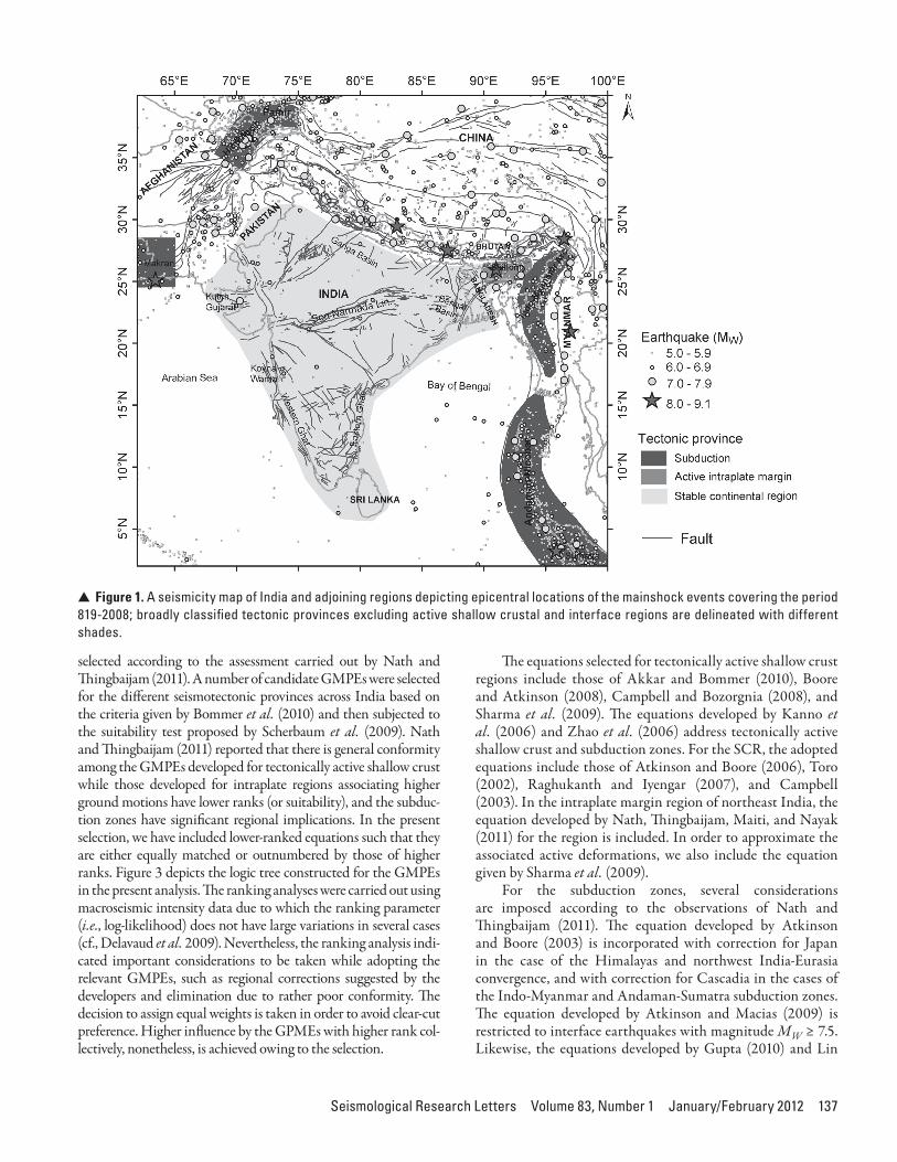
Seismogenic Sources and Seismicity ModelsSeismic hazard analysis studies are facilitated by appraisal of the underlying seismotectonic regimes. "e Indian subcontinent encompasses di$erent seismotectonic provinces as depicted in Figure 1. "e tectonically active interplate regions include the Himalayas, southern Tibetan Plateau, Hindukush-Pamir, Sulaiman-Kirthar ranges, Indo-Myanmar arc, and Andaman-Sumatra belt. "e Shillong Plateau zone in northeast India is
a special case of an “intraplate margin” region associated with active deformations (e.g., Nath and "ingbaijam 2011). On the other hand, peninsular India is delineated as a stable con-tinental region (SCR). "e subduction zones include that of Hindukush-Pamir in the northwest, the Indo-Myanmar arc, and the Andaman-Sumatra seismic belt. Subduction interface earthquakes are also observed across the Himalayas and in the northwestern parts of Indian plate boundary.
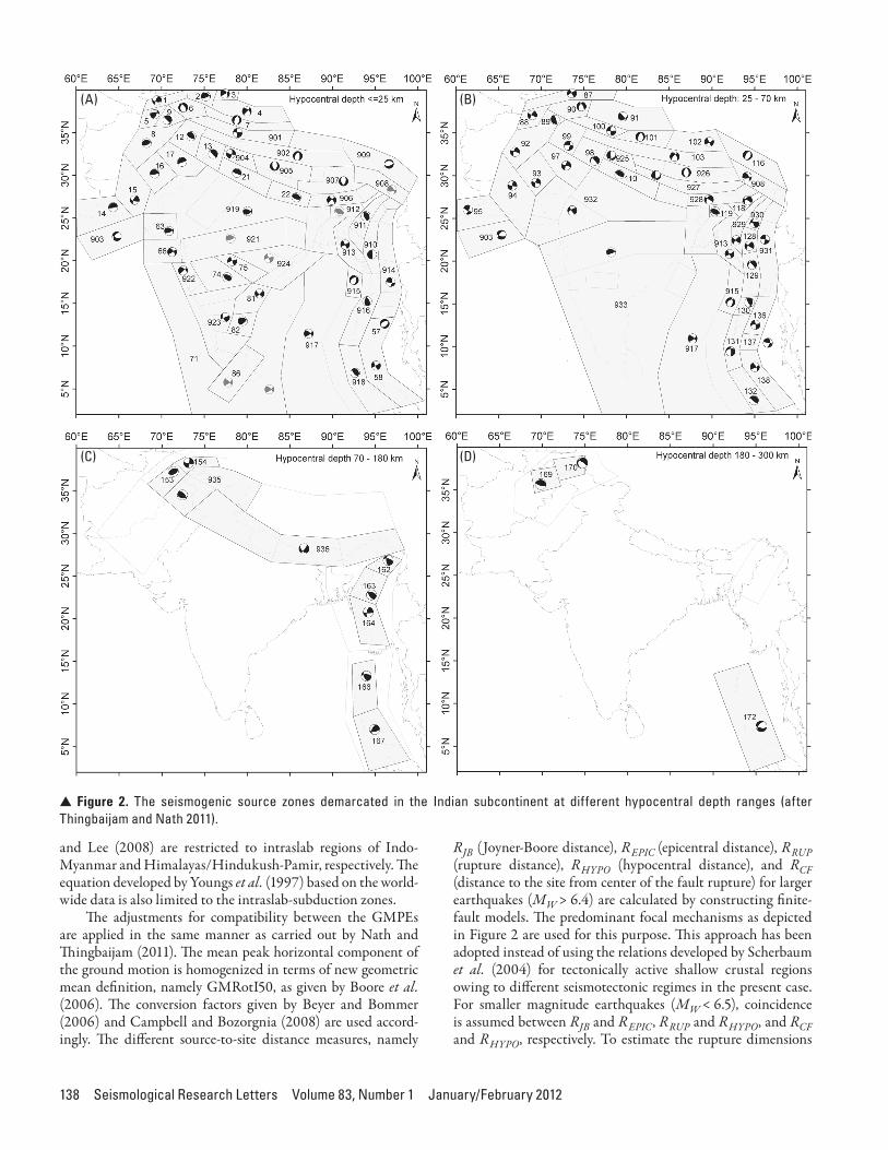
"ingbaijam and Nath (2011) carried out an extensive study to determine and parameterize the underlying seismo-genic source zones in the Indian subcontinent. "ey employed the earthquake catalog (accessible at http://www.earthqhaz.net/sacat/; Nath, "ingbaijam, and Ghosh 2011) supple-mented by records of historical earthquakes (occurring prior to 1900 and as early as A.D. 819), focal mechanism data from the Global Centroid Moment Tensor database and published literature, and palaeoseismicity !ndings. "e fault database, as depicted in Figure 1, has also been employed with the data obtained from the seismotectonic map of India published by the Geological Survey of India (Dasgupta et al. 2000), the seis-motectonic map of Afghanistan and the adjoining region pub-lished by the U.S. Geological Survey (Wheeler and Rukstales 2007) and that given by Wellman (1966), the tectonic map of the Andaman-Sumatra belt given by Curray (1991), and the fault map of Tibet prepared by He and Tsukuda (2003). "ingbaijam and Nath (2011) formulated a layered seismo-genic source zonation corresponding to four hypocentral depth ranges (in km): 0–25, 25–70, 70–180, and 180–300. Figure 2 depicts the areal source zones delineated on the basis of seis-micity, fault patterns, and similarity in fault-plane solutions. "e representative focal mechanism given in the !gure for each zone was derived from the weighted average of the known moment tensors ("ingbaijam and Nath 2011; "ingbaijam 2011). "e Gutenberg and Richter (GR) parameters for the zones, i.e., a-value and b-value, were estimated by means of the maximum likelihood method while the maximum earthquakes mmax was decided according to results of earlier investigations or the seismicity analysis performed by the authors. "e mag-nitude of completeness mc of the earthquake catalog has spatio-temporal variations; this is taken care of while estimating the seismicity parameters for each source zone. "e earthquakes have been assigned to each source zone according to epicenter location and hypocentral depth. "e earthquake occurrences are considered to be random, following a Poissonian distribu-tion. Smoothed seismicity models represented by seismic activ-ity rates at a regular interval of 0.2° were also constructed for threshold magnitudes of MW 4.5 and MW 5.5, respectively. "e threshold magnitudes correspond to the overall variations in the magnitude of completeness for subcatalogs covering the periods 1964–2008 and 1900–2008, respectively (Nath, "ingbaijam, Ghosh 2011; "ingbaijam 2011). "e electronic supplement contains the data !les for all the source zones.
Ground Motion Prediction EquationsWe adopt 16 ground motion prediction equations (GMPEs) as listed in Table 2 for the hazard computations. "e GMPEs are
Seismological Research Letters Volume 83, Number 1 January/February 2012 137
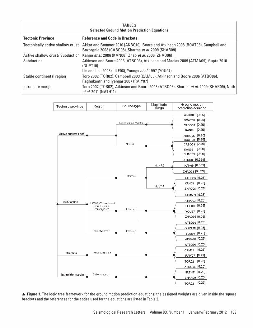
selected according to the assessment carried out by Nath and "ingbaijam (2011). A number of candidate GMPEs were selected for the di$erent seismotectonic provinces across India based on the criteria given by Bommer et al. (2010) and then subjected to the suitability test proposed by Scherbaum et al. (2009). Nath and "ingbaijam (2011) reported that there is general conformity among the GMPEs developed for tectonically active shallow crust while those developed for intraplate regions associating higher ground motions have lower ranks (or suitability), and the subduc-tion zones have signi!cant regional implications. In the present selection, we have included lower-ranked equations such that they are either equally matched or outnumbered by those of higher ranks. Figure 3 depicts the logic tree constructed for the GMPEs in the present analysis. "e ranking analyses were carried out using macroseismic intensity data due to which the ranking parameter (i.e., log-likelihood) does not have large variations in several cases (cf., Delavaud et al. 2009). Nevertheless, the ranking analysis indi-cated important considerations to be taken while adopting the relevant GMPEs, such as regional corrections suggested by the developers and elimination due to rather poor conformity. "e decision to assign equal weights is taken in order to avoid clear-cut preference. Higher in%uence by the GPMEs with higher rank col-lectively, nonetheless, is achieved owing to the selection.
"e equations selected for tectonically active shallow crust regions include those of Akkar and Bommer (2010), Boore and Atkinson (2008), Campbell and Bozorgnia (2008), and Sharma et al. (2009). "e equations developed by Kanno et al. (2006) and Zhao et al. (2006) address tectonically active shallow crust and subduction zones. For the SCR, the adopted equations include those of Atkinson and Boore (2006), Toro (2002), Raghukanth and Iyengar (2007), and Campbell (2003). In the intraplate margin region of northeast India, the equation developed by Nath, "ingbaijam, Maiti, and Nayak (2011) for the region is included. In order to approximate the associated active deformations, we also include the equation given by Sharma et al. (2009).
For the subduction zones, several considerations are imposed according to the observations of Nath and "ingbaijam (2011). "e equation developed by Atkinson and Boore (2003) is incorporated with correction for Japan in the case of the Himalayas and northwest India-Eurasia convergence, and with correction for Cascadia in the cases of the Indo-Myanmar and Andaman-Sumatra subduction zones. "e equation developed by Atkinson and Macias (2009) is restricted to interface earthquakes with magnitude MW ≥ 7.5. Likewise, the equations developed by Gupta (2010) and Lin
V Figure 1. A seismicity map of India and adjoining regions depicting epicentral locations of the mainshock events covering the period 819-2008; broadly classified tectonic provinces excluding active shallow crustal and interface regions are delineated with different shades.
138 Seismological Research Letters Volume 83, Number 1 January/February 2012
and Lee (2008) are restricted to intraslab regions of Indo-Myanmar and Himalayas/Hindukush-Pamir, respectively. "e equation developed by Youngs et al. (1997) based on the world-wide data is also limited to the intraslab-subduction zones.
"e adjustments for compatibility between the GMPEs are applied in the same manner as carried out by Nath and "ingbaijam (2011). "e mean peak horizontal component of the ground motion is homogenized in terms of new geometric mean de!nition, namely GMRotI50, as given by Boore et al. (2006). "e conversion factors given by Beyer and Bommer (2006) and Campbell and Bozorgnia (2008) are used accord-ingly. "e di$erent source-to-site distance measures, namely
RJB (Joyner-Boore distance), REPIC (epicentral distance), RRUP (rupture distance), RHYPO (hypocentral distance), and RCF (distance to the site from center of the fault rupture) for larger earthquakes (MW > 6.4) are calculated by constructing !nite-fault models. "e predominant focal mechanisms as depicted in Figure 2 are used for this purpose. "is approach has been adopted instead of using the relations developed by Scherbaum et al. (2004) for tectonically active shallow crustal regions owing to di$erent seismotectonic regimes in the present case. For smaller magnitude earthquakes (MW < 6.5), coincidence is assumed between RJB and REPIC, RRUP and RHYPO, and RCF and RHYPO, respectively. To estimate the rupture dimensions
(A)
(C)
(B)
(D)
V Figure 2. The seismogenic source zones demarcated in the Indian subcontinent at different hypocentral depth ranges (after Thingbaijam and Nath 2011).
Seismological Research Letters Volume 83, Number 1 January/February 2012 139
TABLE 2Selected Ground Motion Prediction Equations
Tectonic Province Reference and Code in Brackets
Tectonically active shallow crust Akkar and Bommer 2010 (AKBO10), Boore and Atkinson 2008 (BOAT08), Campbell and Bozorgnia 2008 (CABO08), Sharma et al. 2009 (SHAR09)
Active shallow crust/ Subduction Kanno et al. 2006 (KAN06), Zhao et al. 2006 (ZHAO06)Subduction Atkinson and Boore 2003 (ATBO03), Atkinson and Macias 2009 (ATMA09), Gupta 2010
(GUPT10)Lin and Lee 2008 (LILE08), Youngs et al. 1997 (YOU97)
Stable continental region Toro 2002 (TOR02), Campbell 2003 (CAM03), Atkinson and Boore 2006 (ATBO06), Raghukanth and Iyengar 2007 (RAIY07)
Intraplate margin Toro 2002 (TOR02), Atkinson and Boore 2006 (ATBO06), Sharma et al. 2009 (SHAR09), Nath et al. 2011 (NATH11)
V Figure 3. The logic tree framework for the ground motion prediction equations; the assigned weights are given inside the square brackets and the references for the codes used for the equations are listed in Table 2.
140 Seismological Research Letters Volume 83, Number 1 January/February 2012
(i.e., length and width), we use the relations given by Wells and Coppersmith (1994) for crustal events and those given by Strasser et al. (2010) for the subduction earthquakes. For the large intraplate earthquakes with reverse faulting, the fault-rupture area estimated from the magnitude is constrained by a factor of 2 (Nath and "ingbaijam 2011). Following the obser-vation of Mai et al. (2005) that the hypocenters in strike-slip and crustal dip-slip events mostly occur in deeper sections of the fault plane, the location of hypocenter is placed on the plane decided by 0.5 and 0.8 (reverse faulting), 0.5 and 0.4 (strike-slip faulting), and 0.5 and 0.2 (normal faulting) of the rupture length and width, respectively, from the fault location. "e fault location is the top corner of the fault plane such that the dip is on the right-hand side. Depth to shear-wave velocity VS = 1.0 km/s (Z1.0) is estimated using the relation between Z1.0 and VS30 given by Chiou and Youngs (2008) while depth to VS = 2.5 km (Z2.5) is assigned 2 km following Boore and Atkinson (2008). "e computed scenarios consider varying hypocentral depths with homogenous distribution of source-to-site distance not less than 15 km for the shallow crustal zones. "is is to avoid esti-mating ground motions at very near-source locations. Resolving the uncertainty associated with near-source ground motions is currently a topic of active research (Mai 2009). For the lower crust and subduction zones, the minimum hypocentral depths are assigned for the source locations.
Seismic Site ConditionsSite conditions considered in previous PSHA studies in India discussed earlier include hard rock, rock, and sti$ soil conditions. "e site classi!cation scheme given by the National Earthquake Hazards Reduction Program (NEHRP) employs average shear-wave velocity for the upper 30 m soil column VS30 (Building Seismic Safety Council [BSSC] 2001). Nath, "ingbaijam, Maiti et al. (2011) attempted a nationwide assessment of site conditions in India. "ey observed that ~70% of the total land-mass comes under site classes D (VS30 ranging between 180 and 360 m/s) and C (VS30 ranging between 360 and 760 m/s). In view of the site characterization studies across the country, we consider !rm-rock site conditions (standard engineering bed-rock) to be more realistic for the regional hazard computations. "e standard engineering bedrock conforms to VS30~760 m/s (de!ned as boundary site-class BC). "e GMPEs employed in the present analysis are accordingly adopted for the respective site condition uniformly. At the same time, we assume a correc-tion factor of 1 with negligible uncertainty between site-class BC and site-class B (e.g., Boore and Atkinson 2008).
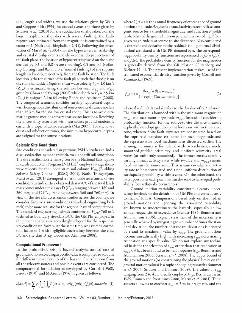
Computational FrameworkIn the probabilistic seismic hazard analysis, annual rate of ground motion exceeding a speci!c value is computed to account for di$erent return periods of the hazard. Contributions from all the relevant sources and possible events are considered. "e computational formulation as developed by Cornell (1968), Esteva (1970), and McGuire (1976) is given as follows:
λ(a>A) = P(a>A|m,r,σ)fm(m)fr(r)fσ(σ) dmdrdσ, (1)
where λ(a>A) is the annual frequency of exceedance of ground motion amplitude A, νi, is the annual activity rate for ith seismo-genic source for a threshold magnitude, and function P yields probability of the ground motion parameter a exceeding A for a given magnitude m at source-to-site distance r. Also considered is the standard deviation of the residuals (in log-normal distri-bution) associated with GMPE, denoted by σ. "e correspond-ing probability density functions are represented by fm(m), fr(r), and fσ(σ). "e probability density function for the magnitudes is generally derived from the GR relation (Gutenberg and Richter 1944). "e present implementation makes use of the truncated exponential density function given by Cornell and Vanmarcke (1969),
fm(m) " eβ β
βxp[ (m mmin )]
1 exp[ (mmax mmin)] , (2)
where β = b ln(10) and b refers to the b-value of GR relation. "e distribution is bounded within the minimum magnitude mmin and maximum magnitude mmax. Instead of considering probability function for the source-to-site distance measure explicitly, we adopt gridded-point locations within the source zone, wherein !nite-fault ruptures are constructed based on the rupture dimensions estimated for each magnitude and the representative focal mechanism as discussed earlier. "e seismogenic source is formulated with two schemes; namely, smoothed-gridded seismicity and uniform-seismicity areal zones (or uniformly smoothed). "e former entails spatially varying annual activity rates while b-value and mmax remain !xed within the source zone. "is assumes b-value and activ-ity rate to be uncorrelated and a non-uniform distribution of earthquake probability within a zone. On the other hand, the latter postulates each point within the zone to have equal prob-ability for earthquake occurrences.
Ground motion variability constitutes aleatory uncer-tainty intrinsic to the de!nition of GMPEs and consequently to that of PHSA. Computations based only on the median ground motions and ignoring the associated variability are known to underestimate the hazards, especially at low annual frequencies of exceedance (Bender 1984; Bommer and Abrahamson 2006). Explicit treatment of the uncertainty is generally achieved by integrating to a number of times the stan-dard deviation; the number of standard deviations is denoted by ε and its maximum value by εmax. "e ground motions become unrealistically high with increasing εmax necessitating truncation at a speci!c value. We do not explore any techni-cal basis for the selection of εmax other than that truncation at εmax < 3 has been found to be inappropriate (e.g., Bommer and Abrahamson 2006; Strasser et al. 2008). "e upper bound of the ground motions (or constraining the physical limits on the ground motion values) is a topic of ongoing research (Bommer et al. 2004; Strasser and Bommer 2009). "e values of εmax ranging from 2 to 4 are usually employed (e.g., Bernreuter et al. 1989; Romeo and Prestininzi 2000; Marin et al. 2004). "ese aspects allow us to consider εmax = 3 to be pragmatic, and the
Seismological Research Letters Volume 83, Number 1 January/February 2012 141
same is accordingly adopted uniformly for all the GMPEs in the present study.
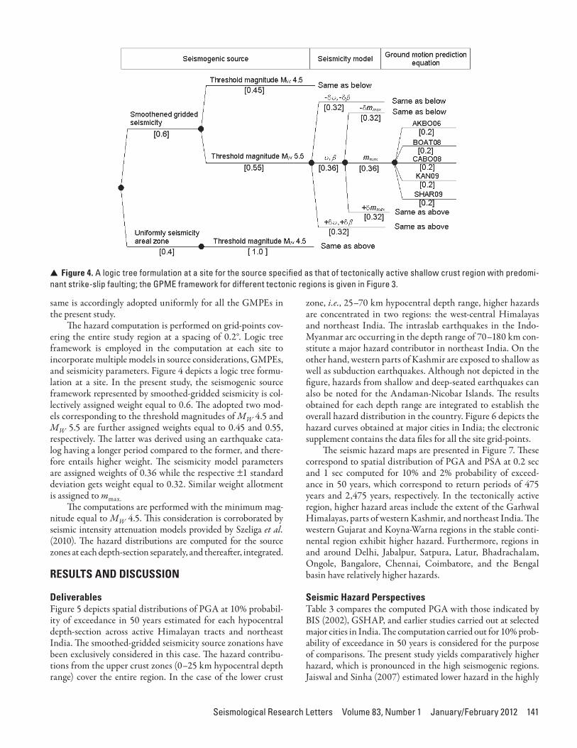
"e hazard computation is performed on grid-points cov-ering the entire study region at a spacing of 0.2°. Logic tree framework is employed in the computation at each site to incorporate multiple models in source considerations, GMPEs, and seismicity parameters. Figure 4 depicts a logic tree formu-lation at a site. In the present study, the seismogenic source framework represented by smoothed-gridded seismicity is col-lectively assigned weight equal to 0.6. "e adopted two mod-els corresponding to the threshold magnitudes of MW 4.5 and MW 5.5 are further assigned weights equal to 0.45 and 0.55, respectively. "e latter was derived using an earthquake cata-log having a longer period compared to the former, and there-fore entails higher weight. "e seismicity model parameters are assigned weights of 0.36 while the respective t1 standard deviation gets weight equal to 0.32. Similar weight allotment is assigned to mmax.
"e computations are performed with the minimum mag-nitude equal to MW 4.5. "is consideration is corroborated by seismic intensity attenuation models provided by Szeliga et al. (2010). "e hazard distributions are computed for the source zones at each depth-section separately, and therea*er, integrated.
RESULTS AND DISCUSSION
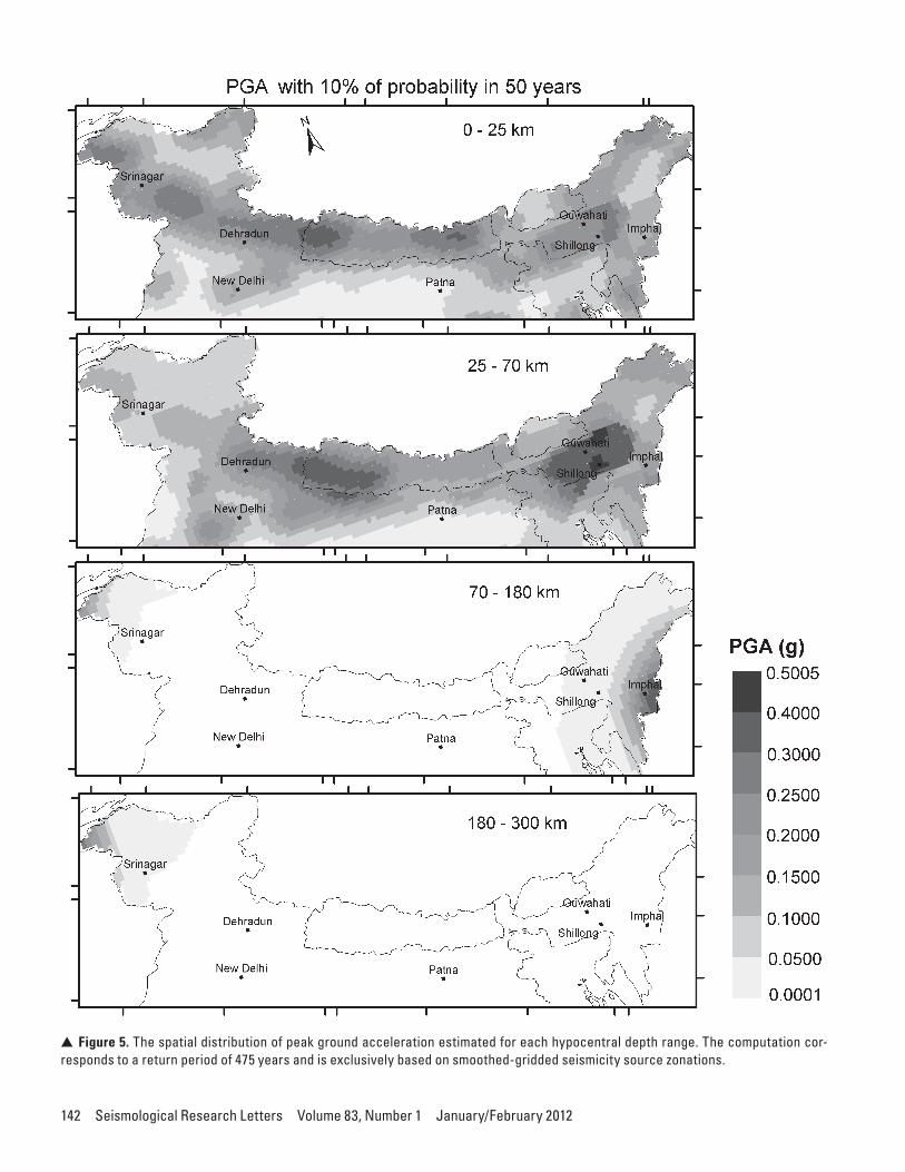
Deliverables Figure 5 depicts spatial distributions of PGA at 10% probabil-ity of exceedance in 50 years estimated for each hypocentral depth-section across active Himalayan tracts and northeast India. "e smoothed-gridded seismicity source zonations have been exclusively considered in this case. "e hazard contribu-tions from the upper crust zones (0–25 km hypocentral depth range) cover the entire region. In the case of the lower crust
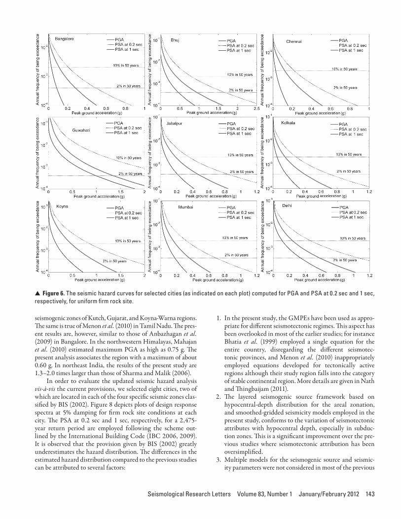
zone, i.e., 25–70 km hypocentral depth range, higher hazards are concentrated in two regions: the west-central Himalayas and northeast India. "e intraslab earthquakes in the Indo-Myanmar arc occurring in the depth range of 70–180 km con-stitute a major hazard contributor in northeast India. On the other hand, western parts of Kashmir are exposed to shallow as well as subduction earthquakes. Although not depicted in the !gure, hazards from shallow and deep-seated earthquakes can also be noted for the Andaman-Nicobar Islands. "e results obtained for each depth range are integrated to establish the overall hazard distribution in the country. Figure 6 depicts the hazard curves obtained at major cities in India; the electronic supplement contains the data !les for all the site grid-points.
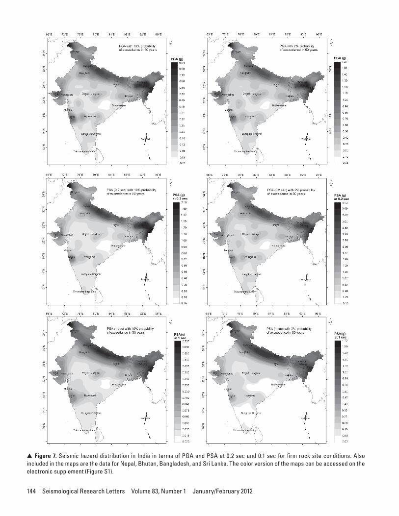
"e seismic hazard maps are presented in Figure 7. "ese correspond to spatial distribution of PGA and PSA at 0.2 sec and 1 sec computed for 10% and 2% probability of exceed-ance in 50 years, which correspond to return periods of 475 years and 2,475 years, respectively. In the tectonically active region, higher hazard areas include the extent of the Garhwal Himalayas, parts of western Kashmir, and northeast India. "e western Gujarat and Koyna-Warna regions in the stable conti-nental region exhibit higher hazard. Furthermore, regions in and around Delhi, Jabalpur, Satpura, Latur, Bhadrachalam, Ongole, Bangalore, Chennai, Coimbatore, and the Bengal basin have relatively higher hazards.
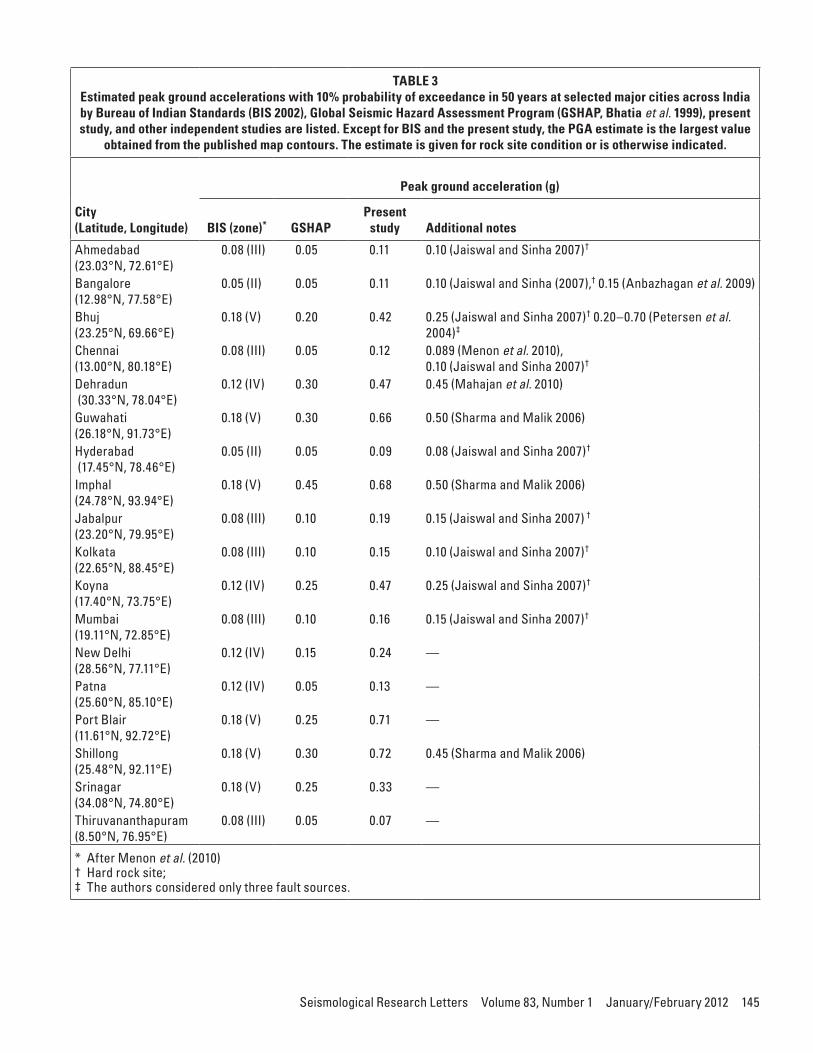
Seismic Hazard Perspectives Table 3 compares the computed PGA with those indicated by BIS (2002), GSHAP, and earlier studies carried out at selected major cities in India. "e computation carried out for 10% prob-ability of exceedance in 50 years is considered for the purpose of comparisons. "e present study yields comparatively higher hazard, which is pronounced in the high seismogenic regions. Jaiswal and Sinha (2007) estimated lower hazard in the highly
V Figure 4. A logic tree formulation at a site for the source specified as that of tectonically active shallow crust region with predomi-nant strike-slip faulting; the GPME framework for different tectonic regions is given in Figure 3.
142 Seismological Research Letters Volume 83, Number 1 January/February 2012
V Figure 5. The spatial distribution of peak ground acceleration estimated for each hypocentral depth range. The computation cor-responds to a return period of 475 years and is exclusively based on smoothed-gridded seismicity source zonations.
Seismological Research Letters Volume 83, Number 1 January/February 2012 143
seismogenic zones of Kutch, Gujarat, and Koyna-Warna regions. "e same is true of Menon et al. (2010) in Tamil Nadu. "e pres-ent results are, however, similar to those of Anbazhagan et al. (2009) in Bangalore. In the northwestern Himalayas, Mahajan et al. (2010) estimated maximum PGA as high as 0.75 g. "e present analysis associates the region with a maximum of about 0.60 g. In northeast India, the results of the present study are 1.3–2.0 times larger than those of Sharma and Malik (2006).
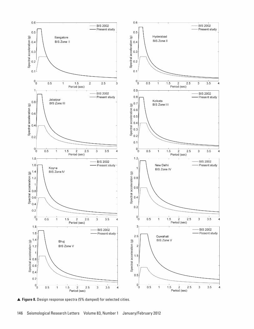
In order to evaluate the updated seismic hazard analysis vis-à-vis the current provisions, we selected eight cities, two of which are located in each of the four speci!c seismic zones clas-si!ed by BIS (2002). Figure 8 depicts plots of design response spectra at 5% damping for !rm rock site conditions at each city. "e PSA at 0.2 sec and 1 sec, respectively, for a 2,475-year return period are employed following the scheme out-lined by the International Building Code (IBC 2006, 2009). It is observed that the provision given by BIS (2002) greatly underestimates the hazard distribution. "e di$erences in the estimated hazard distribution compared to the previous studies can be attributed to several factors:
1. In the present study, the GMPEs have been used as appro-priate for di$erent seismotectonic regimes. "is aspect has been overlooked in most of the earlier studies; for instance Bhatia et al. (1999) employed a single equation for the entire country, disregarding the di$erent seismotec-tonic provinces, and Menon et al. (2010) inappropriately employed equations developed for tectonically active regions although their study region falls into the category of stable continental region. More details are given in Nath and "ingbaijam (2011).
2. "e layered seismogenic source framework based on hypocentral-depth distribution for the areal zonation, and smoothed-gridded seismicity models employed in the present study, conforms to the variation of seismotectonic attributes with hypocentral depth, especially in subduc-tion zones. "is is a signi!cant improvement over the pre-vious studies where seismotectonic attribution has been oversimpli!ed.
3. Multiple models for the seismogenic source and seismic-ity parameters were not considered in most of the previous
V Figure 6. The seismic hazard curves for selected cities (as indicated on each plot) computed for PGA and PSA at 0.2 sec and 1 sec, respectively, for uniform firm rock site.
144 Seismological Research Letters Volume 83, Number 1 January/February 2012
V Figure 7. Seismic hazard distribution in India in terms of PGA and PSA at 0.2 sec and 0.1 sec for firm rock site conditions. Also included in the maps are the data for Nepal, Bhutan, Bangladesh, and Sri Lanka. The color version of the maps can be accessed on the electronic supplement (Figure S1).
Seismological Research Letters Volume 83, Number 1 January/February 2012 145
TABLE 3Estimated peak ground accelerations with 10% probability of exceedance in 50 years at selected major cities across India by Bureau of Indian Standards (BIS 2002), Global Seismic Hazard Assessment Program (GSHAP, Bhatia et al. 1999), present study, and other independent studies are listed. Except for BIS and the present study, the PGA estimate is the largest value
obtained from the published map contours. The estimate is given for rock site condition or is otherwise indicated.
City (Latitude, Longitude)
Peak ground acceleration (g)
BIS (zone)* GSHAP Present
study Additional notes
Ahmedabad (23.03°N, 72.61°E)
0.08 (III) 0.05 0.11 0.10 (Jaiswal and Sinha 2007)†
Bangalore (12.98°N, 77.58°E)
0.05 (II) 0.05 0.11 0.10 (Jaiswal and Sinha (2007),† 0.15 (Anbazhagan et al. 2009)
Bhuj (23.25°N, 69.66°E)
0.18 (V) 0.20 0.42 0.25 (Jaiswal and Sinha 2007)† 0.20–0.70 (Petersen et al. 2004)‡
Chennai (13.00°N, 80.18°E)
0.08 (III) 0.05 0.12 0.089 (Menon et al. 2010), 0.10 (Jaiswal and Sinha 2007)†
Dehradun (30.33°N, 78.04°E)
0.12 (IV) 0.30 0.47 0.45 (Mahajan et al. 2010)
Guwahati (26.18°N, 91.73°E)
0.18 (V) 0.30 0.66 0.50 (Sharma and Malik 2006)
Hyderabad (17.45°N, 78.46°E)
0.05 (II) 0.05 0.09 0.08 (Jaiswal and Sinha 2007)†
Imphal (24.78°N, 93.94°E)
0.18 (V) 0.45 0.68 0.50 (Sharma and Malik 2006)
Jabalpur (23.20°N, 79.95°E)
0.08 (III) 0.10 0.19 0.15 (Jaiswal and Sinha 2007) †
Kolkata (22.65°N, 88.45°E)
0.08 (III) 0.10 0.15 0.10 (Jaiswal and Sinha 2007)†
Koyna (17.40°N, 73.75°E)
0.12 (IV) 0.25 0.47 0.25 (Jaiswal and Sinha 2007)†
Mumbai (19.11°N, 72.85°E)
0.08 (III) 0.10 0.16 0.15 (Jaiswal and Sinha 2007)†
New Delhi (28.56°N, 77.11°E)
0.12 (IV) 0.15 0.24 —
Patna (25.60°N, 85.10°E)
0.12 (IV) 0.05 0.13 —
Port Blair (11.61°N, 92.72°E)
0.18 (V) 0.25 0.71 —
Shillong (25.48°N, 92.11°E)
0.18 (V) 0.30 0.72 0.45 (Sharma and Malik 2006)
Srinagar (34.08°N, 74.80°E)
0.18 (V) 0.25 0.33 —
Thiruvananthapuram (8.50°N, 76.95°E)
0.08 (III) 0.05 0.07 —
* After Menon et al. (2010)† Hard rock site; ‡ The authors considered only three fault sources.
146 Seismological Research Letters Volume 83, Number 1 January/February 2012
V Figure 8. Design response spectra (5% damped) for selected cities.
Seismological Research Letters Volume 83, Number 1 January/February 2012 147
studies, except for Jaiswal and Sinha (2007) and Menon et al. (2010).
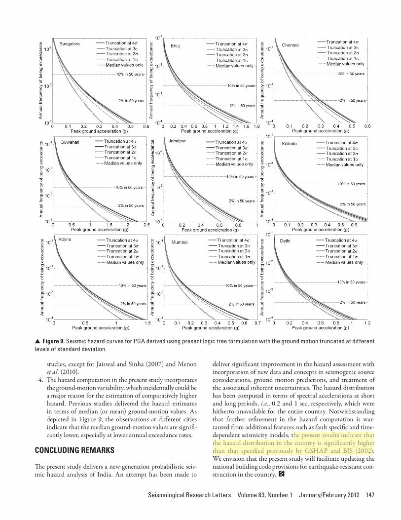
4. "e hazard computation in the present study incorporates the ground-motion variability, which incidentally could be a major reason for the estimation of comparatively higher hazard. Previous studies delivered the hazard estimates in terms of median (or mean) ground-motion values. As depicted in Figure 9, the observations at di$erent cities indicate that the median ground-motion values are signi!-cantly lower, especially at lower annual exceedance rates.
CONCLUDING REMARKS
"e present study delivers a new-generation probabilistic seis-mic hazard analysis of India. An attempt has been made to
deliver signi!cant improvement in the hazard assessment with incorporation of new data and concepts in seismogenic source considerations, ground motion predictions, and treatment of the associated inherent uncertainties. "e hazard distribution has been computed in terms of spectral accelerations at short and long periods, i.e., 0.2 and 1 sec, respectively, which were hitherto unavailable for the entire country. Notwithstanding that further re!nement in the hazard computation is war-ranted from additional features such as fault speci!c and time-dependent seismicity models, the present results indicate that the hazard distribution in the country is signi!cantly higher than that speci!ed previously by GSHAP and BIS (2002). We envision that the present study will facilitate updating the national building code provisions for earthquake-resistant con-struction in the country.
V Figure 9. Seismic hazard curves for PGA derived using present logic tree formulation with the ground motion truncated at different levels of standard deviation.
148 Seismological Research Letters Volume 83, Number 1 January/February 2012
ACKNOWLEDGMENTS
"e critical comments and constructive suggestions from Jonathan M. Lees and an anonymous reviewer greatly improved the scienti!c exposition of the manuscript. KKST is grateful to K. D. Singh, Indian Institute of Technology Guwahati, for the stimulating discussions on design response spectra.
REFERENCES
Akkar, S., and J. J. Bommer (2010). Empirical equations for the pre-diction of PGA, PGV, and spectral accelerations in Europe, the Mediterranean region, and the Middle East. Seismological Research Letters 81, 195–s206.
Anbazhagan, P., and T. G. Sitharam (2009). Spatial variability of the depth of weathered and engineering bedrock using multichannel analysis of surface wave method. Pure and Applied Geophysics 166, 409–428.
Anbazhagan, P., J. S. Vinod, and T. G. Sitharam (2009). Probabilistic seismic hazard analysis for Bangalore. Natural Hazards 48, 145–166.
Atkinson, G. M., and D. M. Boore (2003). Empirical ground-motion relations for subduction-zone earthquakes and their application to Cascadia and other regions. Bulletin of the Seismological Society of America 93, 1,703–1,729.
Atkinson, G. M., and D. M. Boore (2006). Earthquake ground-motion predictions for eastern North America. Bulletin of the Seismological Society of America 96, 2,181–2,205.
Atkinson, G. M., and M. Macias (2009). Predicted ground motions for great interface earthquakes in the Cascadia subduction zone. Bulletin of the Seismological Society of America 99, 1,552–1,578.
Basu, S., and N. C. Nigam (1977). Seismic risk analysis of Indian pen-insula. In Proceedings of Sixth World Conference on Earthquake Engineering, New Delhi. Vol. 1, 782–1,788.
Bender, B. (1984). Incorporating acceleration variability into seismic hazard analysis. Bulletin of the Seismological Society of America 74, 1,451–1,462.
Bernreuter, D. L., J. B. Savy, R. W. Mensing, and J. C. Chen (1989). Seismic Hazard Characterization of 69 Nuclear Power Plant Sites East of the Rocky Mountains. U.S. Nuclear Regulatory Commission Report NUREG/CR-5250.
Beyer, K., and J. J. Bommer (2006). Relationships between median val-ues and between aleatory variabilities for di$erent de!nitions of the horizontal component of motion. Bulletin of the Seismological Society of America 96, 1,512–1,522.
Bhatia, S. C., M. R. Kumar, and H. K. Gupta (1999). A probabilistic seis-mic hazard map of India and adjoining regions. Annali di Geo$sica 42, 1,153–1,166.
Bommer, J. J., and N. A. Abrahamson (2006). Why do modern proba-bilistic seismic-hazard analyses o*en lead to increased hazard esti-mates? Bulletin of the Seismological Society of America 96, 1,967–1,977.
Bommer, J. J., N. A. Abrahamson, F. O. Strasser, A. Pecker, P.-Y. Bard, H. Bungum, F. Cotton, D. Fäh, F. Sabetta, F. Scherbaum, and J. Studer (2004). "e challenge of de!ning upper bounds on earth-quake ground motions. Seismological Research Letters 75, 82–95.
Bommer, J. J., J. Douglas, F. Scherbaum, F. Cotton, H. Bungum, and D. Fäh (2010). On the selection of ground-motion prediction equa-tions for seismic hazard analysis. Seismological Research Letters 81, 794–801.
Bommer, J. J., F. Scherbaum, H. Bungum, F. Cotton, F. Sabetta, and N. A. Abrahamson (2005). On the use of logic trees for ground-motion prediction equations in seismic-hazard analysis. Seismological Research Letters 95, 377–389.
Boore, D. M., and G. M. Atkinson (2008). Ground-motion prediction equations for the average horizontal component of PGA, PGV, and 5%-damped PSA at spectral periods between 0.01 s and 10.0 s. Earthquake Spectra 24, 99–138.
Boore, D. M., J. Watson-Lamprey, and N. A. Abrahamson (2006). Orientation-independent measures of ground motion. Bulletin of the Seismological Society of America 96, 1,502–1,511.
Building Seismic Safety Council (BSSC) (2001). NEHRP Recommended Provisions for Seismic Regulations for New Buildings and Other Structures. 2000 Edition, Part 1: Provisions, Building Seismic Safety Council for the Federal Emergency Management Agency (Report FEMA 368), Washington, DC.
Bureau of Indian Standards (BIS) (2002). IS 1893–2002 (Part 1): Indian Standard Criteria for Earthquake Resistant Design of Structures, Part 1–General Provisions and Buildings. New Delhi: Bureau of Indian Standards.
Campbell, K. W. (2003). Prediction of strong ground motion using the hybrid empirical method and its use in the development of ground-motion (attenuation) relations in eastern North America. Bulletin of the Seismological Society of America 93, 1,012–1,033.
Campbell, K. W., and Y. Bozorgnia (2008). NGA ground motion model for the geometric mean horizontal component of PGA, PGV, PGD and 5% damped linear elastic response spectra for periods ranging from 0.01 to 10s. Earthquake Spectra 24, 139–171.
Chiou, B., and R. R. Youngs (2008). An NGA model for the average hor-izontal component of peak ground motion and response spectra. Earthquake Spectra 24, 173–215.
Cornell, C. A. (1968). Engineering seismic risk analysis. Bulletin of the Seismological Society of America 58, 1,583–1,606.
Cornell, C. A., and E. H. Vanmarcke (1969). "e major in%uence on seis-mic risk. %e Fourth World Conference on Earthquake Engineering, Santiago, Chile, 69–93.
Curray, J. R. (1991). Possible greenschist metamorphism at the base of a 22-km sedimentary section, Bay of Bengal. Geology 19, 1,097–1,100.
Das, S., I. D. Gupta, and V. K. Gupta (2006). A probabilistic seismic haz-ard analysis of northeast India. Earthquake Spectra 22, 1–27.
Dasgupta, S., P. Pande, D. Ganguly, Z. Iqbal, K. Sanyal, N.V. Venaktraman, S. Dasgupta, B. Sural, L. Harendranath, K. Mazumadar, S. Sanyal, A. Roy, L. K. Das, P. S. Misra, and H. Gupta (2000). Seismotectonic Atlas of India and Its Environs. Calcutta: Geological Survey, India.
Delavaud, E., F. Scherbaum, N. Kuehn, and C. Riggelsen (2009). Information-"eoretic Selection of Ground-Motion Prediction Equations for Seismic Hazard Analysis: An Applicability Study Using Californian Data, Bulletin of the Seismological Society of America 99, 3,248–3,263.
Esteva, L. (1970). Seismic risk and seismic design decisions. In Seismic Design for Nuclear Power Plants, ed. R. J. Hansen, 142–182. Cambridge, MA: Massachusetts Institute of Technology Press.
Guha, S. K. (1962). Seismic regionalization of India. In Proceedings of Second Symposium on Earthquake Engineering, Roorkee, India, 191–207.
Gupta, I. D. (2010). Response spectral attenuation relations for in-slab earthquakes in Indo-Burmese subduction zone. Soil Dynamics and Earthquake Engineering 30, 368–377.
Gutenberg, B., and C. F. Richter (1944). Frequency of earthquakes in California. Bulletin of the Seismological Society of America 34, 185–188.
He, H., and E. Tsukuda (2003). Recent progresses of active fault research in China, Journal of Geology 112, 489–520.
International Building Code (IBC) (2006). International Building Code. Club Hills, IL: International Code Council.
International Building Code (IBC) (2009). International Building Code. Country Club Hills, IL: International Code Council, Inc.
Jaiswal, K., and R. Sinha (2004). Web portal on earthquake disaster awareness in India; http://www.earthquakeinfo.org.
Seismological Research Letters Volume 83, Number 1 January/February 2012 149
Jaiswal, K., and R. Sinha (2007). Probabilistic seismic-hazard estimation for peninsular India. Bulletin of the Seismological Society of America 97, 318–330.
Kanno, T., A. Narita, N. Morikawa, H. Fujiwara, and Y. Fukushima (2006). A new attenuation relation for strong ground motion in Japan based on recorded data. Bulletin of the Seismological Society of America 96, 879–897.
Khattri, K. N. (2006). A need to review the current o+cial seismic zon-ing map of India. Current Science 90, 634–636.
Khattri, K. N., A. M. Rogers, D. M. Perkins, and S. T. Algermissen (1984). A seismic hazard map of India and adjacent areas. Tectonophysics 108, 93–134.
Krishna, J. (1959). Seismic zoning of India. In Earthquake Engineering Seminar, Roorkee University, India, 32–38.
Kulkarni, R. B., R. R. Youngs, and K. J. Coppersmith (1984). Assessment of con!dence intervals for results of seismic hazard analysis. In Proceedings, Eighth World Conference on Earthquake Engineering, vol.1, San Francisco, 263–270.
Lin, P. S., and C. T. Lee (2008). Ground-motion attenuation relation-ships for subduction-zone earthquakes in northeastern Taiwan. Bulletin of the Seismological Society of America 98, 220–240.
Mahajan, A. K., V. C. "akur, M. L. Sharma, and M. Chauhan (2010). Probabilistic seismic hazard map of NW Himalaya and its adjoin-ing area, India. Natural Hazards 53, 443–457.
Mai, P. M. (2009). Ground motion: Complexity and scaling in the near !eld of earthquake ruptures. In Encyclopedia of Complexity and Systems Science, ed. R. Meyers, vol. 4, 4,435–4,474.New York: Springer.
Mai, P. M., P. Spudich, and J. Boatwright (2005). Hypocenter locations in !nite-source rupture models. Bulletin of the Seismological Society of America 95, 965–980.
Marin, S., J.-P. Avouac, M. Nicolas, and A. Schlupp (2004). A probabi-listic approach to seismic hazard in metropolitan France. Bulletin of the Seismological Society of America 94, 2,137–2,163.
McGuire, R. K. (1976). FORTRAN Computer Program for Seismic Risk Analysis. USGS Open-File Report 76–67.
Menon, A., T. Ornthammarath, M. Corigliano, and C. G. Lai (2010). Probabilistic seismic hazard macrozonation of Tamil Nadu in southern India. Bulletin of the Seismological Society of America 100, 1,320–1,341.
Nath, S. K., and K. K. S. "ingbaijam (2011). Peak ground motion pre-dictions in India: An appraisal for rock sites. Journal of Seismology 15, 295–315.
Nath S. K., K. K. S. "ingbaijam, M. D. Adhikari, A. Nayak, N. Devaraj, S. K. Ghosh, A. K. Mahajan (2011), Topographic gradient based site characterization in India complemented by strong ground-motion spectral attributes.
Nath, S. K., K. K. S. "ingbaijam, and S. K. Ghosh (2011). A uni!ed earthquake catalogue for South Asia covering the period 1900–2008. Data accessible at http://www.earthqhaz.net/sacat/.
Nath, S. K., K. K. S. "ingbaijam, S. K. Maiti, and A. Nayak (2011). Ground motion predictions in Shillong region, northeast India.
Petersen, M. D., B. K. Rastogi, E. S. Schweig, S. C. Harmsen, and J. S. Gomberg (2004). Sensitivity analysis of seismic hazard for the northwestern portion of the state of Gujarat, India. Tectonophysics 390, 105–115.
Raghukanth, S. T. G., and R. N. Iyengar (2007). Estimation of seismic spectral acceleration in peninsular India. Journal of Earth System Science 116, 199–214.
Romeo, R., and A. Prestininzi (2000). Probabilistic versus deterministic hazard analysis: An integrated approach for siting problems. Soil Dynamics and Earthquake Engineering 20, 75–84.
Scherbaum, F., E. Delavaud, and C. Riggelsen (2009). Model selection in seismic hazard analysis: An information-theoretic perspective. Bulletin of the Seismological Society of America 99, 3,234-3,247.
Scherbaum, F., J. Schmedes, and F. Cotton (2004). On the conversion of source-to-site distance measures for extended earthquake source models. Bulletin of the Seismological Society of America 94, 1,053–1,069.
Sharma, M. L., J. Douglas, H. Bungum, and J. Kotadia (2009). Ground-motion prediction equations based on data from the Himalayan and Zagros regions. Journal of Earthquake Engineering 13, 1,191–1,210.
Sharma, M. L., and S. Malik (2006). Probabilistic seismic hazard analy-sis and Estimation of spectral strong ground motion on bedrock in northeast India. Fourth International Conference on Earthquake Engineering, Taipei, Taiwan, paper no. 15.
Strasser, F. O., M. C. Arango, and J. J. Bommer (2010). Scaling of the source dimensions of interface and intraslab subduction-zone earthquakes with moment magnitude. Seismological Research Letters 81, 941–950.
Strasser, F. O., and J. J. Bommer (2009). Strong ground motions—have we seen the worst? Bulletin of the Seismological Society of America 99, 2,613–2,637.
Strasser, F. O., J. J. Bommer, and N. A. Abrahamson (2008). Truncation of the distribution of ground-motion residuals. Journal of Seismology 12, 79–105.
Szeliga W., S. Hough, S. Martin, and R. Bilham (2010). Intensity, mag-nitude, location, and attenuation in India for felt earthquakes since 1762. Bulletin of the Seismological Society of America 100, 570–584.
Tandon, A. N. (1956). Zones of India liable to earthquake damage. Indian Journal of Meteorological Geophysics 10, 137–146.
"ingbaijam, K. K. S. (2011). Synoptic modeling for probabilistic seismic hazard analysis of India. PhD thesis, Indian Institute of Technology Kharagpur, India.
"ingbaijam, K. K. S., and S. K. Nath (2011). A seismogenic source framework for Indian subcontinent.
Toro, G. R. (2002). Modi!cation of the Toro et al. (1997) attenuation equa-tions for large magnitudes and short distances. Risk Engineering, Inc.: http://www.riskeng.com/PDF/atten_toro_extended.pdf
Wellman, H. N. (1966). Active wrench faults of Iran, Afghanistan and Pakistan, Geologische Rundschau 55, 716–735.
Wells, D. L., and K. J. Coppersmith (1994). New empirical relationships among magnitude, rupture length, rupture width, rupture area, and surface displacement. Bulletin of the Seismological Society of America 84, 974–1,002.
Wheeler, R. L., and K. S. Rukstales (2007). Seismotectonic map of Afghanistan and adjacent areas. U.S. Geological Survey Open-File Report 2007-1104.
Youngs, R. R., S.-J. Chiou, W. J. Silva, and J. R. Humphrey (1997). Strong ground motion relationships for subduction earthquakes. Seismological Research Letters 68, 58–73.
Zhao, J. X., J. Zhang, A. Asano, Y. Ohno, T. Oouchi, T. Takahashi, H. Ogawa, K. Irikura, H. K. "io, P. G. Somerville, Y. Fukushima, and Y. Fukushima (2006). Attenuation relations of strong ground motion in Japan using site classi!cation based on predominant period. Bulletin of the Seismological Society of America 96, 898–913.
Department of Geology and GeophysicsIndian Institute of Technology Kharagpur
Kharagpur 721 302 [email protected]
(S. K. N.)[email protected]
(K. K. S. T.)