probabilistic seismic hazard assessment in terms...
TRANSCRIPT
First Draft PROBABILISTIC SEISMIC HAZARD ASSESSMENT IN TERMS OF
ENGINEERING PARAMETERS IN GREECE
G-Akis Tselentis, Laurentin Danceu and Thimios Sokos
University of patras Seismological Lab
RIO 265 00, Greece
ABSTRACT
The present study is a probabilistic seismic hazard assessment in terms of well
known engineering parameters, presented for the first time for the region of Greece.
The following ground motion parameters have been investigated and mapped using
the recently published attenuation relationships (predictive equations) of Danciu and
Tselentis (2007), based on strong motion recordings of Greek earthquakes: peak
ground acceleration, peak ground velocity, spectral velocity, elastic input energy for
0.2 and 1 sec, Arias intensity, cumulated absolute velocity (CAV), CAV5 and spectral
intensity. A Poissonian model of earthquake occurrence is assumed and the
corresponding hazard maps on the basis of the recommendations in EUROCODE8
(475 year return period) are evaluated.
INTRODUCTION
Conventionally, Probabilistic Seismic Hazard Analysis (PSHA) for a given site or
region have been evaluated in terms of peak ground acceleration or spectral
acceleration estimated at a specified period and damping. Although, these parameters
are certainly convenient parameters for design of earthquake-resistant structures,
some of the important characteristics associated to the ground motion, such as
duration, frequency- and energy- content are not captured by their definitions. The
importance of duration, frequency- and energy- content for non-linear response has
been recognized, but these ground motion characteristics are still not used in the
building design codes.
Many attempts have been done to employ ground motion characteristics into
seismic design in the basis of the so-called energy-based seismic design methods
(Benavent-Climent et al. 2002; Chai and Fajfar 2000; Decanini and Mollaioli 1998;
Housner 1956; Uang and Bertero 1988). Although there is not a general established
1
energy-based seismic design method yet; these investigations highlight the
importance of using duration and energy parameters to describe the reliable design
earthquake, as they adequately capture the destructive potential of the different type
of time histories (impulsive, non-impulsive, periodic with long-duration pulses, etc)
corresponding to an earthquake.
For performance-based design, the ground motions may need to be specified by
acceleration time histories consistent with the expected earthquake scenarios. The
acceleration time histories can be selected to reflect an earthquake scenario; scaled to
match or exceed the controlling design earthquake over a period of interest; or
generated on the basis of a model of the earthquake source. Therefore, in the view of
seismic hazard, the ground motion characteristics are essential and the measures that
reflect these characteristics should be considered in all seismic hazard assessment.
This study deals with PSHA in terms of engineering seismic parameters such as:
peak ground acceleration (PGA), peak ground velocity (PGV), spectral velocity (Sv)
and elastic input energy (VEi) at selected frequencies and damping, Arias intensity
(Ia), cumulated absolute velocity (CAV), CAV5 and spectral intensity (SI). Work in
progress will assess the effect that these models have on probabilistic seismic hazard
analysis. These engineering ground motion parameters are supposed to be objective
measures of ground motion damage potential and have geotechnical and structural
application.
In the framework of the PSHA, Ia has begun to be considered as one of the basic
ground motions measures. Abdrakhmatov et al. (2003) have computed a probabilistic
seismic hazard analysis in terms of Ia for the territory of Kyrgyzstan, and Peláez et al.
(2005) for south-eastern Spain. Both studies have shown that Ia is a good landslide
hazard descriptor.
Probabilistic seismic hazard maps, in terms of SI and considering local soil
conditions were reported by Peruzza et al. (2000). The major findings of that study
was that the SI, can well synthesise the overall information available from traditional
probabilistic studies, but also suggests that soil condition is a first-order ingredient for
effective seismic hazard mapping at national level.
Recently, the Electric Power Research Institute – (EPRI), have established a CAV
criterion as an alternative to the classic conservative lower bound body wave
magnitude cut-off value of 5.0 (approximate moment magnitude of 4.6) to integrate
into the PSH. The application of a minimum CAV value significantly reduces the
2
contribution of small magnitude earthquakes to the total hazard. The magnitude of the
dominant earthquake is shown to increase from 5.25 to 5.8 by applying the minimum
CAV as a filter. This example shows that the past PSHA studies that used a minimum
moment magnitude of 4.6 can overestimate the hazard by including earthquakes that
are not damaging but contribute significantly to the hazard when they are located at
short distances from the site, (EPRI 2006).
Chapman (1999) studied the implication of VEi in PSHA. The study concluded
that if the PSH was assessed on the basis of VEi, strong magnitude earthquakes
contributed more to total hazard compared to a conventional elastic response
spectrum-based hazard assessment. It should be mentioned here, that a similar
conclusion is derived from a comparison between duration-based and acceleration-
based seismic hazard assessments, (Koutrakis et al., 2002).
The broad area of Greece constitutes the overriding plate of the Africa-Eurasia
convergent plate system, defining one of the most active plate tectonic regimes in the
world and is characterized with high seismic hazard. Thus, the assessment of seismic
hazard in Greece has been the subject of a growing number of studies during the last
decades.
In Greece, the seismic hazard assessment, has been evaluated as the maximum
expected intensity (Papaioannou 1984; Papaioannou and Papazachos 2000;
Papazachos et al., 1985; Papoulia and Slejko 1997; Shebalin et al., 1975) or as PGA,
PGV and strong motion duration (Algermissen et al., 1976; Banitsiotou et al., 2004;
Burton et al., 2003a; Koutrakis et al., 2002; Makropoulos and Burton 1985;
Mantyniemi et al., 2004; Papaioannou 1984; Papazachos et al., 1993; Papazachos et
al., 1990; Papazachos et al., 1992; Theodulidis and Papazachos 1992; Tsapanos 2003;
Tsapanos et al., 2003)
Papazachos et al. (1993) have reported seismic hazard maps for Greece based on
PGA, PGV and macroseismic intensity. The results of the hazard analysis, i.e. the
seismic hazard parameters versus the mean return period for T = 475 yr were fitted by
log-linear equation, and based on these recurrence relationships, four zones of equal
seismic hazard were reported for the territory of Greece.
3

Papaioannou and Papazachos (2000) have investigated seismic hazard in Greece
using both time-independent and time-dependent models. They reported results for
144 broad sites and the major finding was the new seismic regionalization of the
broader Aegean area. They have employed PGA, PGV and macroseismic intensity as
hazard parameters; they fitted seismic hazard parameters versus the mean return
period for T = 475 yr by log-linear equation; and reported the expected values for the
144 sites.
Koutrakis et al. (2002) assessed the PSHA for Greece in term of duration and
PGA. The study proposed new predictive equations for bracketed duration of strong
motion valid for the region under consideration; and the PSHA results are presented
in the form of a map according to which Greece is classified in four different
categories of equal seismic hazard.
Recently, Tselentis et al. (2005) have developed probabilistic seismic hazard maps
in terms of Ia for Greece. The reported Ia seismic hazard maps were proposed by
authors using rock site conditions and for a period of 50 & 100 years with 90%
probability of non-exceedance. These maps can be used additionally as a base for
seismic hazard landslides mapping in the territory of Greece.
The major aim of this study was to incorporate the engineering ground motion
parameters for the first time into PSHA analysis. The study considered the recently
proposed predictive equations by Danciu and Tselentis (2007). Secondary aim of the
present study was to investigate the relationship between estimated values of the
engineering ground motion parameters and mean return period, assuming time-
independent occurrence of earthquakes. The return periods derived for this
relationship were fitted by linear regression and results were reported for 144 broad
sites.
The seismic hazard maps for the estimated engineering ground motion parameters
and the results presented here are released for information and discussion and are not
meant to be linked to any kind of regulation.
GROUND MOTION PARAMETERS
The engineering ground motion parameters, selected to describe the earthquake
destructiveness potential, can be classified as structure-independent or structure-
dependent. The structure-independent parameters: PGV, Ia, CAV, CAV5, are simple
in definition, based only on the recorded acceleration time history and have general
4
applications (Danciu and Tselentis 2007). Generally speaking, the independent-
structure parameters would reflect the level of ground motion on the short-period
structures.
Structure-dependent parameters: SI, VEi, and Sv are based on recorded
acceleration time history and physical characteristics of the structure. They request
more computational effort than structure-independent parameters and are appropriate
for structure specific analysis. Elastic input energy-Ei for PSHA is converted into
elastic input energy-equivalent velocity - VEi. The structure-dependent parameters SV
and VEi were computed for both short and long periods: 0.2 and 1.0 sec and at 5%
damping ratio. Short period Sv (0.2s) and VEi (0.2s) reflect the level of shaking that
will have effects on short-period structures (one-to two story buildings). Long period
Sv (1.0s) and VEi (1.0s) reflect the level of shaking that will have effect on longer-
period structures (10+ story buildings). Due, to its definition, SI would reflect the
ground motion effects on the long period structures.
Therefore, by taking into account these ground motion parameters, herein referred
as engineering ground motion parameters, into the seismic hazard analysis, a better
distribution of the earthquake damage potential can be defined. This will support the
selection of proper earthquake scenarios and proper characterization of the earthquake
time histories for structural design. Moreover, by using consistent hazard parameters,
the PSHA results would conduce to improved visualization of equal seismic hazard,
improved regionalization of the hazard.
PROBABILISTIC SEISMIC HAZARD METHODOLOGY
The PSHA methodology was introduced more than forty years ago, in the landmark
papers by Cornel (1968)and McGuire (1976)), since then it has become the most
widely used approach to the problem of determining the characteristics of strong
ground motion for engineering design (Bommer 2002).
In essence, the PSHA is expressed in terms of exceedance probability per unit
time period, of a given measure of ground motion intensity at a site by integrating the
contributions of available geological, seismological and statistical information. The
annual hazard curves are the result of the probabilistic hazard analysis for a site; for a
given region the hazard maps can be obtained by simultaneously hazard analysis for
many sites in the selected region and constructing iso-maps for specified ground
motion levels corresponding to given return periods.
5

The analysis of seismic hazard at a site requires an approach for estimating the
probability that various levels of ground motion will be exceeded at a selected
location in some period of interest. A PSHA computational scheme involves the
following constitutive models:
• Seismic sources
• Earthquake recurrence relationships
• Ground motion predictive equations (attenuation laws)
• Ground motion occurrence probability
The PSHA yields the annual frequency of exceedance of different ground motion
levels for each of the selected engineering ground motion parameters. The result of
PSHA at a given site is evaluated by this relationship ground motion level-annual
frequency of exceedance, called ground-motion hazard curve. By performing
simultaneously hazard analysis for a given region the hazard maps can be obtained by
simultaneously hazard analysis for many sites in the selected region and constructing
iso-maps for specified ground motion levels corresponding to given return periods.
The procedure to develop seismic hazard maps based on engineering ground motion
parameters is the same as for those based on PGA computations, but the predictive
equations (attenuation lows) are different.
In the present study, we have retained the use of seismic source zones in the
absence of detailed information about the activity rate of specific faults in Greece. In
the present investigation we have adopted the most recent seismic source model
regarding geographical distribution of seismo-tectonic zones in Greece, as has been
proposed by Papaioannou and Papazachos (2000), the boundaries of which were
chosen to reflect the seismicity adequately regarding tectonic units and lithospheric
structure. Herein, a number of 67 shallow seismic source zones were used and the
geographical distribution of these zones is presented on Figure 1. For the seismic
zones considered, the slope (b-value) and the intercept (a-value) used in the present
investigation are those reported in Table1 of Papaioannou and Papazachos (2000).
The set of predictive equations developed for engineering ground motion
parameters and proposed by Danciu and Tselentis (2007) was selected herein. The
selected predictive equations are based on strong motion data primary from Greek
shallow earthquakes. Therefore we don’t consider here the contribution of
intermediate depth earthquakes that are present at the south Aegean area and probably
6
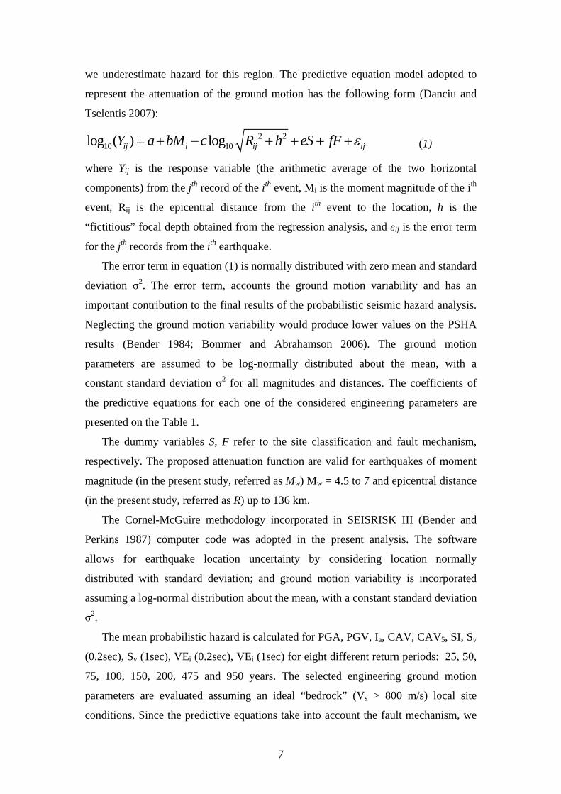
we underestimate hazard for this region. The predictive equation model adopted to
represent the attenuation of the ground motion has the following form (Danciu and
Tselentis 2007):
2 210 10log ( ) logij i ij ijY a bM c R h eS fF ε= + − + + + + (1)
where Yij is the response variable (the arithmetic average of the two horizontal
components) from the jth record of the ith event, Mi is the moment magnitude of the ith
event, Rij is the epicentral distance from the ith event to the location, h is the
“fictitious” focal depth obtained from the regression analysis, and εij is the error term
for the jth records from the ith earthquake.
The error term in equation (1) is normally distributed with zero mean and standard
deviation σ2. The error term, accounts the ground motion variability and has an
important contribution to the final results of the probabilistic seismic hazard analysis.
Neglecting the ground motion variability would produce lower values on the PSHA
results (Bender 1984; Bommer and Abrahamson 2006). The ground motion
parameters are assumed to be log-normally distributed about the mean, with a
constant standard deviation σ2 for all magnitudes and distances. The coefficients of
the predictive equations for each one of the considered engineering parameters are
presented on the Table 1.
The dummy variables S, F refer to the site classification and fault mechanism,
respectively. The proposed attenuation function are valid for earthquakes of moment
magnitude (in the present study, referred as Mw) Mw = 4.5 to 7 and epicentral distance
(in the present study, referred as R) up to 136 km.
The Cornel-McGuire methodology incorporated in SEISRISK III (Bender and
Perkins 1987) computer code was adopted in the present analysis. The software
allows for earthquake location uncertainty by considering location normally
distributed with standard deviation; and ground motion variability is incorporated
assuming a log-normal distribution about the mean, with a constant standard deviation
σ2.
The mean probabilistic hazard is calculated for PGA, PGV, Ia, CAV, CAV5, SI, Sv
(0.2sec), Sv (1sec), VEi (0.2sec), VEi (1sec) for eight different return periods: 25, 50,
75, 100, 150, 200, 475 and 950 years. The selected engineering ground motion
parameters are evaluated assuming an ideal “bedrock” (Vs > 800 m/s) local site
conditions. Since the predictive equations take into account the fault mechanism, we
7

performed hazard calculation in two steps. During the first step, hazard calculation
was performed considering only normal fault mechanism, while on the second step
the contribution of the thrust and strike slip faults was added. Therefore, we divided
the seismogenic sources in two categories, as can be seen on the Figure 1, based on
their seismotectonic characteristics and hazard results were overlapped.
The geographical territory of Greece spanning the area 19oW - 30oEast and 34oS
to 42oN was divided into a mesh of points with an interval of 0.1o (about 10km) both
in latitude and longitude.
Furthermore, 144 sites were selected to geographically cover the area of the
seismic zones included in the Greek Seismic Code – EAK (2003). The updated
version of EAK 2003 divides into three different zones of seismic hazard the country
based on PGA and macroseismic intensity. The selected sites together with the equal
seismic hazard zones defined by EAK 2003 are presented on the Figure 2.
For every site, the expected engineering ground motion parameters at the selected
return periods were computed. Next, the sites were classified accordingly to the
zonation presented in the EAK 2003; then for each zone the expected values were
averaged and finally, the results were fitted with a simple linear regression of the
form:
10 10log logY a b X= + (1)
where Y is the estimated engineering ground motion parameter, X is the mean return
period, and a, b are the intercept and the slope obtained by fitting the data. Following
the aforementioned approach, one could obtain the engineering ground motion
parameters for a given site and for a given return period.
PSHA RESULTS
The results of PSHA as mentioned previously have been generated in the form of
hazard curves for the 144 selected sites that were distributed within the three equal
seismic hazard zones. The recurrence relationships for the three zones, defined by the
EAK 2003, are shown in Figure 3 to 4; and summarized in Table 2. The plots in
Figure 3 depict the recurrence relationships for the three seismic zones based on PGA,
PGV, Ia, CAV, CAV5, SI and selected mean return periods. Figure 4 presents Sv and
VEi at the selected periods of 0.2s and 1.0s. It can be observed that the fitted lines
corresponding to the three different zones of equal hazard tend to increase with
8

increasing return period, achieving greater PGA values for the third seismic hazard
zone.
Following the results summarized in Table 2 estimated ground motion parameters,
for different return periods and different seismic zones can be assessed. For
comparison, a mean return period of 475 years is selected and for the three seismic
hazard zones the engineering parameters estimated are compared with the estimated
parameters defined by EAK 2003. The results are shown on Table 3, and in addition,
the table has been completed with the values corresponding PGA, PGV, macroseismic
intensity and bracketed duration reported elsewhere (Koutrakis et al., 2002;
Papaioannou and Papazachos 2000). The aforementioned studies have reported the
PSHA results for the old Greek Seismic Code –NEAK, which consider four equal
seismic hazard zones.
The updated version - EAK 2003 incorporates the first two seismic zones defined
in NEAK as being one seismic hazard zone with a lower acceleration level equal to
0.16g. Comparing the estimated PGA values on the Table 3 it can be observed that the
PGA values estimated in the present study exhibit higher values for all seismic hazard
zones. This difference can be explained by the fact that the present study considers the
uncertainty in the ground motion estimates. We have investigated the sensitivity of
accounting the standard deviation of the PGA predictive equations for the selected
seismic hazard zones. The results are reported on the same table, and as it can be seen
an increase of almost 15% in PGA is obtained for all equal seismic hazard zones.
Furthermore, the relationship between macroseismic intensity and engineering
parameters estimated at the selected sites (144) has been investigated. For all these
sites, the estimated engineering parameters accompanied by the macroseismic
intensity reported by Papaioannou and Papazachos (2000) for a return period of 475
years are reported on Table 4. It can be observed that the maximum predicted values
of the intensity and engineering parameters does not occur at the same sites.
The higher estimated intensity values occur at the sites surrounding the Southern
Aegean while the maximum engineering parameters values arise into the Western
Aegean. This discrepancy can be explained by the fact that the Southern Aegean
region is dominated by intermediate depth earthquakes. These intermediate seismic
zones have not been considered into the present analysis, thus the PSHA results in
these region are underestimated.
9

Another remark can be done, by comparing the results of the sites nr 7 –
Alexandroupolis and nr 77 – Kyparissia. For both sites the value of reported intensity
(at the mean return period of 475years) is the same 7.55. The values of the estimated
engineering parameters differ, and it can be observed that the estimated values at the
site nr 77 – Kyparissia are larger that those presented at the site nr 7 –
Alexandroupolis. The sites are located on different seismogenic zones, described by
different annual rates. The site nr.7 – Alexandroupolis is located in the zone with an
annual rate of earthquakes with magnitude greater than 5.0 equal to 0.158. The annual
rate of earthquakes with magnitude greater than 5.0 for the site nr.77 – Kyparissia is
equal to 0.960.
Therefore, the engineering parameters reports improved contribution to the hazard
of frequent earthquakes, while the intensity does not. To convert the hazard from
engineering parameters to intensity, we have fitted the results form Table 4 by a
simple linear regression of the form of Eq. 1, where Y is the macroseismic intensity
and X the engineering parameters. The equations, the associated coefficient of the
determination R2 (R-sqrt) and fitted lines for all the parameters are plotted in the
Figures 5 and 6. The probabilistic seismic hazard, for a return period of 475 years, at
any of these sites can be assessed in terms of macroseismic intensity by converting the
estimated engineering parameters into intensity.
An alternate approach of reporting the PSHA results is the representation of the
estimated hazard parameters in the form of contour maps. In the following the
probabilistic seismic hazard maps of Greece based on the selected engineering ground
motion parameters are presented. We assume a mean return period of 475 years and
soil category rock for all the sites. The present maps are compared with the equal
seismic hazard zones defined by EAK 2003 and plotted on Figure 2.
A brief inspection of the hazard maps pointed out the primary difference produced
by the different quantities that are mapped – different ground motion parameters. The
reported maps identify the four regions in the Western, Southern and Northern
Aegean (Hellenic trench) where the seismic hazard is relatively high compared with
other. It is worth to mention here, that the presented hazard maps show the contours
of the estimated ground motion parameters and the amount of interpolation depends
upon the data points available thus, the maximum values may be located inside the
contours.
10
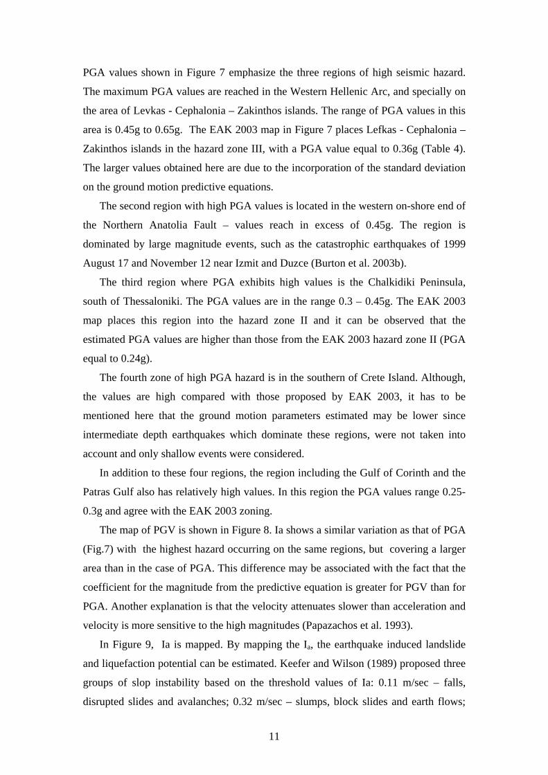
PGA values shown in Figure 7 emphasize the three regions of high seismic hazard.
The maximum PGA values are reached in the Western Hellenic Arc, and specially on
the area of Levkas - Cephalonia – Zakinthos islands. The range of PGA values in this
area is 0.45g to 0.65g. The EAK 2003 map in Figure 7 places Lefkas - Cephalonia –
Zakinthos islands in the hazard zone III, with a PGA value equal to 0.36g (Table 4).
The larger values obtained here are due to the incorporation of the standard deviation
on the ground motion predictive equations.
The second region with high PGA values is located in the western on-shore end of
the Northern Anatolia Fault – values reach in excess of 0.45g. The region is
dominated by large magnitude events, such as the catastrophic earthquakes of 1999
August 17 and November 12 near Izmit and Duzce (Burton et al. 2003b).
The third region where PGA exhibits high values is the Chalkidiki Peninsula,
south of Thessaloniki. The PGA values are in the range 0.3 – 0.45g. The EAK 2003
map places this region into the hazard zone II and it can be observed that the
estimated PGA values are higher than those from the EAK 2003 hazard zone II (PGA
equal to 0.24g).
The fourth zone of high PGA hazard is in the southern of Crete Island. Although,
the values are high compared with those proposed by EAK 2003, it has to be
mentioned here that the ground motion parameters estimated may be lower since
intermediate depth earthquakes which dominate these regions, were not taken into
account and only shallow events were considered.
In addition to these four regions, the region including the Gulf of Corinth and the
Patras Gulf also has relatively high values. In this region the PGA values range 0.25-
0.3g and agree with the EAK 2003 zoning.
The map of PGV is shown in Figure 8. Ia shows a similar variation as that of PGA
(Fig.7) with the highest hazard occurring on the same regions, but covering a larger
area than in the case of PGA. This difference may be associated with the fact that the
coefficient for the magnitude from the predictive equation is greater for PGV than for
PGA. Another explanation is that the velocity attenuates slower than acceleration and
velocity is more sensitive to the high magnitudes (Papazachos et al. 1993).
In Figure 9, Ia is mapped. By mapping the Ia, the earthquake induced landslide
and liquefaction potential can be estimated. Keefer and Wilson (1989) proposed three
groups of slop instability based on the threshold values of Ia: 0.11 m/sec – falls,
disrupted slides and avalanches; 0.32 m/sec – slumps, block slides and earth flows;
11

and 0.54 m/sec – lateral spreads and flows. These threshold contours were plotted on
the map and it appears that for some regions where high topographic relief is
combined with the high Arias intensity estimated values there is significant slope
instability potential. Ia values as high as 500 cm/sec2 were computed in the western
Hellenic Arc and in the western on-shore end of the Northern Anatolia Fault. The
latest region is dominated by large magnitude events
Figure 10 and 11 summarize the maps of the estimated CAV and CAV5 values.
These maps have similar pattern with the previous maps, in sense that they predict
higher hazard for the same regions as the other parameters does. Moreover, by
investigating the CAV map, the regions of high hazard can be clearly identified.
The hazard map associated to SI is presented in Figure 12. The SI increases the
distribution of the regions with high hazard. The high SI values are presented starting
from the western to the southern part of the Hellenic Arc. The region exhibits SI
values larger than 60 cm. The same SI is observed in the northern Hellenic Arc and in
Corinth Gulf. It should be noted that the SI map and PGV map are similar and
mutually corroborative. Both maps exhibit extended hazard for the region spanned
from the west to the southern Hellenic Arc. This region has been reported by EAK
2003 as zone II, but based on the SI results the region appears to expect higher hazard.
The period-dependent parameters Sv and VEi for periods of 0.2 and 1.0 sec are
shown in Figures13a-b and Figures 14a-b respectivelly. From the comparison of the
four maps it becomes clear that the regions with the high hazard are similar with the
previous reported hazard maps. By studying the Sv and VEi maps for short period of
0.2 sec it can be observed that the VEi values are larger. This is due to the fact that for
short periods the VEi is asymptotic to the maximum spectral velocity, while the
spectrum velocity approaches zero (Chapman 1999).
Comparing the maps for Sv and VEi computed at 1sec, it can be observed that VEi
exhibit larger values. The geographical distribution of the hazard is slightly different;
the regions with high seismic hazard are covering a larger area. This is due to the fact,
that the influence of long-period is more evident into the case of the regions
dominated by large magnitude earthquakes. These differences, between the
geographical distributions of the period-dependent parameters infer that a single
seismic hazard map for all periods may not be sufficient.
CONCLUSIONS
12

Seismic hazard analyses implementing engineering ground motion parameters related
to the seismic response of various kinds of structures to ground shaking has a great
importance in all mitigation policies of seismic risk.
In this investigation we have developed new hazard maps for Greece, taking into
account damage-related ground motion parameters which have the advantage to
“capture” the effects of amplitude, frequency content and/or duration of a ground
motion record.
The contours of the estimated hazard for all the engineering ground motion
parameters show a general agreement in identifying the high hazardous regions, but
other areas of moderate to high values differ as frequency changes. This indicates the
usefulness of representation of seismic hazard analysis based on more than one
ground motion parameters.
The hazard maps based on PGA or single spectral parameter is not able to
represent the full description of the level of shaking expected at a given site. For a
widespread region or territory, it is difficult to report the seismic hazard for complete
spectra, thus by combination of short-period dependent parameters with long-period
dependent parameters will better capture the earthquake damage destructiveness.
The engineering ground motion parameters are expected to become more common
in the future seismic hazard analyses. For hazard purpose, the engineering ground
motion parameters would be mapped as an addition to the traditional seismic hazard
maps, based on peak or spectral ground acceleration. For design purpose, this will
support the selection of suitable earthquake scenarios, thus the selection of
appropriate earthquake time histories.
13
REFERENCES
Abdrakhmatov K., Havenith H.-B., Delvaux D., Jongmans D., and Trefois P. (2003).
"Probabilistic PGA and Arias Intensity maps of Kyrgyzstan (Central Asia)."
Journal of Seismology, 7, 203-220.
Algermissen, S. T., Perkins, D. M., Isherwood, W., Gordon, D., Reagor, G., and
Howard, C. "Seismic risk evaluation of the Balkan region." Proc. Sem.
Seismic Zoning Maps, UNESCO, Skopje,Vol.2, 172-240.
Banitsiotou, I. D., Tsapanos, T. M., Margaris, V. N., and Hatzidimitriou, P. M.
(2004). "Estimation of the seismic hazard parameters for various sites in
Greece using a probabilistic approach." Natural Hazards and Earth System
Sciences, 4, 399–405.
Benavent-Climent, A., Pujades, L. G., and Lopez-Almansa, F. (2002). "Design energy
input spectra for moderate-seismicity regions." Earthquake Engineering and
Structural Dynamics, 31, 1151–1172.
Bender, B. (1984). "Incorporating acceleration variability into seismic hazard
analysis." Bulletin of the Seismological Society of America, 74(4), 1451-1462.
Bender, B. K., and Perkins, D. M. (1987). "SEISRISKIII -- A computer program for
seismic hazard estimation." U.S. Geological Survey Bulletin, 1772, 1-48.
Bommer, J. J. (2002). "Deterministic vs. probabilistic seismic hazard assessment: an
exaggerated and obstructive dictophomy." Journal of Earthquake
Engineering, 6(Special Issue 1), 43-73.
Bommer, J. J., and Abrahamson, N. A. (2006). "Why Do Modern Probabilistic
Seismic-Hazard Analyses Often Lead to Increased Hazard Estimates?"
Bulletin of the Seismological Society of America, 96(6), 1967-1977.
14

Burton, P. W., Xu, Y., Tselentis, G.-A., Sokos, E., and Aspinall, W. (2003a). "Strong
Ground acceleration seismic hazard in Greece and neighboring regions." Soil
Dynamics and Earthquake Engineering, 23, 159-181.
Burton, P. W., Yebang, X., Tselentis, G.-A., Sokos, E., and Aspinall, W. (2003b).
"Strong ground accelaration seismic hazard in Greece and neighboring
regions." Soil Dynamics and Earthquake Engineering, 23, 159-181.
Chai, Y. H., and Fajfar, P. (2000). "A Procedure for Estimating Input Energy Spectra
for Seismic Design." Journal of Earthquake Engineering, 4(4), 539-561.
Chapman, M. C. (1999). "On the use of elastic input energy for seismic hazard
analysis. ." Earthquake Spectra, 15(4), 607-635.
Cornell, C. A. (1968). "Engineering Seismic Risk Analysis." Bulletin of the
Seismological Society of America, 58, 1583-1606.
Danciu, L., and Tselentis, G.-A. (2007). "Engineering ground motion parameters
attenuatin relationships for Greece." Bulletin of the Seismological Society of
America, 97(1B), 1-22.
Decanini, L., and Mollaioli, F. (1998). "Formulation of Elastic Earthquake Input
Energy Spectra." Earthquake Engineering and Structural Dynamics, 27, 1503-
1522.
EAK. (2003). "Greek Seismic Code. Earth-quake Planning & Protection Organiza-
tion." Athens-Greece, ed., 72 pp and 7 ap-pendixes (in Greek).
EPRI. (2006). "Use of Cumulative Absolute Velocity (CAV) in Determining Effects
of Small Magnitude Earthquakes on Seismic Hazard Analyses." TR-1014099,
Electrical Power Research Institute, Palo Alto, CA.
Housner, G. W. "Limit design of structures to resist earthquakes." Proc. 1st. World
Conference Earthquake Engineering, Berkeley, California,EERI.
15

Keefer, D. K., and Wilson, R. C. (1989). "Predicting Earthquake induced landslides
with emphasis on arid or semi-arid environments." In Sadler P.M. and Morton
D.M. (eds.), Landslides in a Semi-Arid Environment, Inland Geological
Society, 2, 118-149.
Koutrakis, S. I., Karakaisis, G. F., and Margaris, V. N. (2002). "Seismic hazard in
Greece based on different strong motion parameters. ." Journal of Earthquake
Engineering, 6(1), 75-109.
Makropoulos, K. C., and Burton, P. W. (1985). "Seismic Hazard in Greece:II. Ground
Acceleration." Tectonophysics, 117, 259-294.
Mantyniemi, P., Tsapanos, T. M., and Kijko, A. (2004). "An Estimate of Probabilistic
Seismic Hazard for Five Cities in Greece by Using the Parametric-historic
Procedure." Engineering Geology, 72, 217-231.
McGuire, R. K. (1976). "FORTRAN Computer Program for Seismic Risk Analysis,."
U.S. Geol. Surv., Open file rep.76–67,69pp.
Papaioannou, C. A. (1984). "Attenuation of seismic intensities and seismic hazard
assessment in Greece and the surrounding area,." Ph.D.thesis, University of
Thessaloniki, 200 pp. (In Greek with an English abstract).
Papaioannou, C. A., and Papazachos, B. C. (2000). "Time-Independent and Time-
Depended Seismic Hazard in Greece Based on Seismogenic Sources." Bulletin
of the Seismological Society of America, 90, 22-33.
Papazachos, B. C., Kiratzi, A. A., Hatzidimitriou P.M., Papaioannou, C. A., and
Theodulidis N.P. "Regionalization of seismic hazard in Greece." Proc.12th
Reg.Sem.on Earthq.Eng.EAEE-EPPO, Halkidiki-Greece, 12pp.
16
Papazachos, B. C., Papaioannou, C., Margaris, B. N., and Theodulidis, N. P. (1993).
"Regionalization of Seismic Hazard in Greece Based on Seismic Sources."
Natural Hazards, 8.
Papazachos, B. C., Papaioannou, C. A., Papastamatiou, D. J., Margaris, V. N., and
Theodulidis, N. P. (1990). "On the reliability of dierent methods of the seismic
hazard assessment in Greece." Natural Hazards, 3, 141-151.
Papazachos, C. B., Margaris, B. N., Theodulidis, N., and Papaioannou, C. "Seismic
hazard assessment in Greece based on strong motion duration." Proceedings
on the10th World Conf. Earthquake Engineering, 425-430.
Papoulia, J. E., and Slejko, D. (1997). "Seismic hazard assessment in the Ionian
Islands based on observed macroseismic intensities." Natural Hazards, 14,
179-187.
Pelaeza J.A., Delgado J., and Casado C.L. (2005). "A preliminary probabilistic
seismic hazard assessment in terms of Arias intensity in southeastern Spain."
Engineering Geology 77 139–151.
Peruzza, L., Rebez, A., Slejko, D., and Bragato, P. L. (2000). "The Umbria Marche
case: some suggestions for the Italian seismic zonation." Soil Dynamics and
Earthquake Engineering 20, 361-371.
Shebalin, N. V., Reisner, G. I., Dfrumea, A. V., Aptekman, J. V., Sholpo, V. N.,
Stepaneks, N. Y., and Zacharova, A. J. "Earthquake origin zones and
distribution of maximum expected seismic intensity for teh Balkan region."
Proc.Sem.Seismic Zoning Maps, Skopje, 68-171.
Theodulidis, N. P., and Papazachos, B. C. (1992). "Dependence of strong ground
motion on magnitude-distance, site geology and macroseismic intensity for
17
shallow earthquakes in Greece: I, peak horizontal acceleration, velocity and
displacement." Soil Dynamics and Earthquake Engineering, 11, 387–402.
Tsapanos, T. M. (2003). "A seismic hazard scenario for the main cities of Crete
island, Greece." Geophys.J.Int.(153), 403-408.
Tsapanos, T. M., Papadopoulos G.A., and Galanis, O. G. (2003). "Time independent
seismic hazard analysis of Greece deduced from Bayesian statistics." Natural
Hazards and Earth System Sciences, 3, 129-134.
Tselentis, G.-A., Danciu, L., and Gkika, F. "Empirical Arias Intensity attenuation
relationships for seismic hazard analysis of Greece." ERES Conference,
Greece.
Uang, C. M., and Bertero, V. V. (1988). "Implications of recorded earthquake ground
motions on seismic design of building structures." Report No. UCB/EERC-
88/13,Earthquake Engineering Research Center, Berkeley,CA.
18
TABLES
2 210 10log ( ) logij i ij o o ijY a bM c R h eS fF ε= + + + + + +
Table 1: Coefficients of the predictive equations (attenuation laws) selected for the present study.
Table 2: Regression coefficients of the recurrence relationships between estimated ground motion parameters and different mean return periods for the three zones defined by EAK 2003
19
Table 4: Mean values for engineering parameters estimated for Mean-return Period of 475 Years and for all the seismic hazard zones considered in the two Greek Seismic Code: NEAK (1993) and EAK (2003)
20
Table 5: Estimated engineering parameters and intensity (475 years) for the 144 selected sites
21
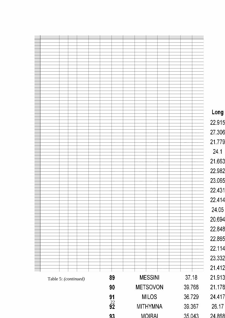
Table 5: (continued)
22

FIGURES
Figure 1: Geographical distribution of the major shallow earthquakes (Mw> 5) and the
seismogenic sources proposed by Papaioannou and Papazachos (2000). Grey filled sources correspond to thrust and strike slip faulting style.
Figure 2: The seismic hazard zonation of Greece according to the Greek Seismic
Code – EAK 2003
23

Figure 3: Recurrence relationships of mean ground motion parameters and different mean return periods for the three zones defined by EAK 2003: (a) PGA, (b) PGV, (c) Ia, (d) CAV, (e) CAV5 and (f) SI.
24

Figure 4: Recurrence relationships of mean ground motion parameters and different mean return periods for the three zones defined by EAK 2003: (a) Sv (0.2 sec), (b) Sv (1 sec), (c) VEi (0.2 sec) and (d) VEi (1 sec).
25

Figure 5: Fitted line results for (a) PGA, (b) PGV, (c) Ia, (d) CAV, (e) CAV5 and (f) SI vs. macroseismic intensity estimated for the 144 sites at a constant mean return period of 475 years.
26

Figure 6: Fitted line results for ((a) Sv (0.2 sec), (b) Sv (1 sec), (c) VEi (0.2 sec) and (d) VEi (1 sec).vs. macroseismic intensity estimated for the 144 sites at a constant mean return period of 475 years.
27
Figure 7: Seismic hazard map in term of PGA for Greece. Results are for an ideal bedrock soil condition estimated at mean return period of 475 years
Figure 8: Seismic hazard map in term of PGV for Greece. Results are for an ideal bedrock soil condition estimated at mean return period of 475 years
28

Figure 9: Seismic hazard map in term of Ia for Greece. Results are for an ideal bedrock soil condition estimated at mean return period of 475 years
Figure 10: Seismic hazard map in term of CAV for Greece. Results are for an ideal
bedrock soil condition estimated at mean return period of 475 years
29

Figure 11: Seismic hazard map in term of CAV5 for Greece. Results are for an ideal
bedrock soil condition estimated at mean return period of 475 years
Figure 12: Seismic hazard map in term of SI for Greece. Results are for an ideal
bedrock soil condition estimated at mean return period of 475 years
30
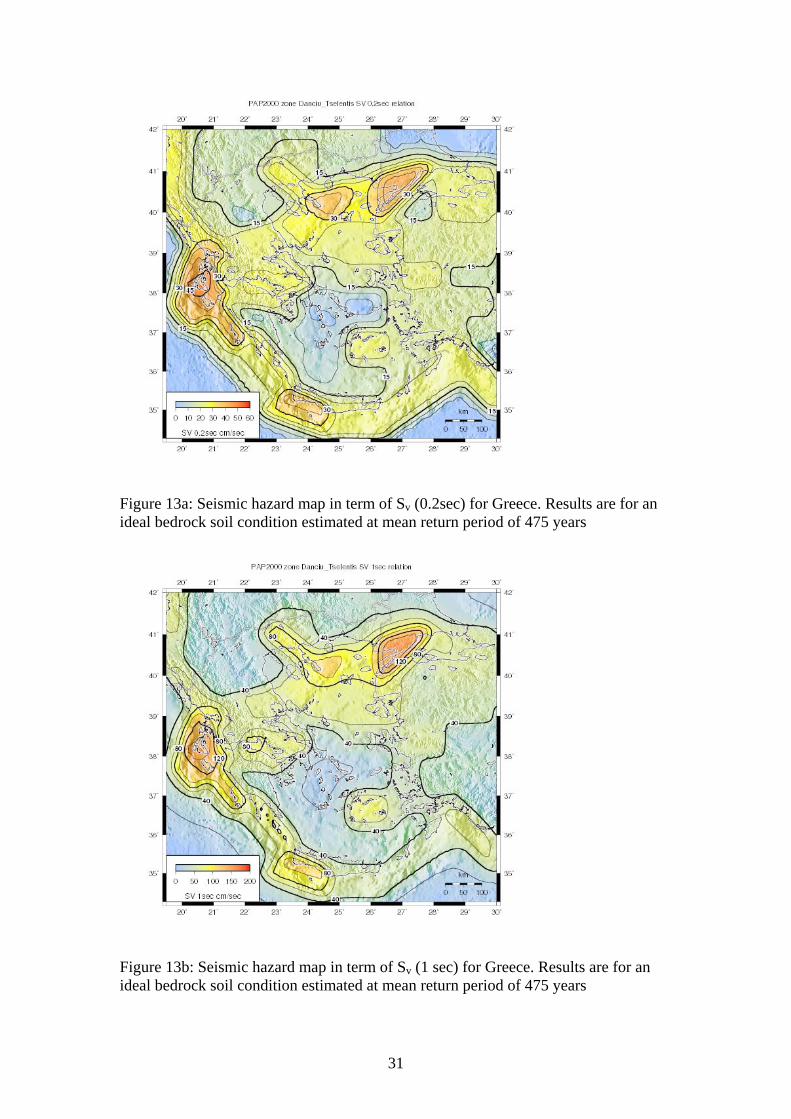
Figure 13a: Seismic hazard map in term of Sv (0.2sec) for Greece. Results are for an ideal bedrock soil condition estimated at mean return period of 475 years
Figure 13b: Seismic hazard map in term of Sv (1 sec) for Greece. Results are for an ideal bedrock soil condition estimated at mean return period of 475 years
31

Figure 14a: Seismic hazard map in term of VEi (0.2sec) for Greece. Results are for an ideal bedrock soil condition estimated at mean return period of 475 years
Figure 14b: : Seismic hazard map in term of VEi (1sec) for Greece. Results are for an ideal bedrock soil condition estimated at mean return period of 475 years
32