preserving water supply infrastructure - cdn.ymaws.com · design and permitting – spillway...
TRANSCRIPT

October 2017
November 2017
Rehabilitation of Glenville Lake Dam –Preserving Water Supply Infrastructure
Danielle K. Neamtu

2017 Annual NC AWWA-WEA Conference
Project Team
Owner – Public Works Commission of Fayetteville• Joseph E. Glass, P.E. (Water Resources Engineering Manager)• Chris Smith (Water Treatment Facilities)• Chad Ham (Water Resources Environmental Program Manager)
Engineer – CDM Smith, Inc.• Steve Whiteside, P.E. (Lead Practitioner)• Danielle Neamtu, P.E. (EOR – Civil)• Justin Boggs, P.E. (EOR-Structural) • Richard Semo (Resident Project Representative)
Contractor – Crowder Construction

3 2017 Kentucky-Tennessee Water Professionals Conference
Outline
Background Design and Permitting Construction Lessons Learned Post-Construction Performance

4 2017 Kentucky-Tennessee Water Professionals Conference
Background

2017 Annual NC AWWA-WEA Conference
Background
• Glenville Lake Dam is located on Little Cross Creek at the Glenville Water Treatment Plant in Fayetteville, North Carolina
5

2017 Annual NC AWWA-WEA Conference
Background
• Glenville Lake is one of four dams on Little Cross Creek owned and maintained by the Public Works Commission of the City of Fayetteville (FPWC)
• Glenville Lake is one of two water sources for FPWC; the other source is an intake on the Cape Fear River
6

2017 Annual NC AWWA-WEA Conference
Historic Flooding
• Okeechobee Hurricane of 1928• Homestead Hurricane of 1945• Hurricane Floyd 1999
7
Three of the five major historic North Carolina floods have impacted Fayetteville
Flooding in Fayetteville, NC 1945. Source: Fayetteville Observer; photo from The Bill Belch Collection

2017 Annual NC AWWA-WEA Conference
Historic Flooding• Most significant flood in
Fayetteville, North Carolina since 1945 was the September 15, 1989 storm. Over 7 inches of rain fell in 6 hours due to cluster of thunderstorm events.
8
Flooding in Fayetteville, NC Sept. 1989. Source: Fayetteville Observer-Times Publishing Company; photo by Steve Aldridge

2017 Annual NC AWWA-WEA Conference
Dam Features• Earth embankment dam with length of 850 feet and height of 21.5 feet was
constructed circa 1909 with 40-foot-wide concrete ogee principal spillway• Impoundment capacity at normal pool is 230.5 acre-feet and drainage area inclusive
of upstream lakes is approximately 22 square miles
Former WTP and Auxiliary Bottom Drain
Existing WTP
Principal Spillway
9

2017 Annual NC AWWA-WEA Conference
Design and Permitting

2017 Annual NC AWWA-WEA Conference
Design and Permitting - Preliminary Design
• Inspection• Heavy Vegetation/Steepness of Upstream
Slopes• Steepness of Downstream Slope, right of
spillway and potential soft/wet areas downstream of toe
• Spillway Concrete Deterioration• Survey• Geotechnical Investigation
• 5 geotechnical borings completed as piezometers for long-term monitoring
11

2017 Annual NC AWWA-WEA Conference
Principal Spillway and Auxiliary Bottom Drain
12

2017 Annual NC AWWA-WEA Conference
Design and Permitting - Re-inspection
• Deterioration and Potential leaks noted• Lake drawn down for inspection of spillway
• Low-level Outlet • Spillway Concrete Deterioration
13

2017 Annual NC AWWA-WEA Conference
Design and Permitting - Re-inspection
• Concrete Coring • Loss of Sand Core• Spillway Replacement Recommended
14

2017 Annual NC AWWA-WEA Conference
Design and Permitting – Spillway Replacement
• Classified as Small High Hazard Dam, Design Storm = 1/3 Probable Maximum Precipitation (9.98 inches in 6 hours)
• New H/H Models developed for both upstream and downstream of the dam and demonstrated the following:
• Existing spillway undersized• New spillway could not have upstream or downstream impacts to 100-year
flood levels (FEMA No-rise)• Additional spillway capacity achieved by adding secondary weir to pass
flows above the 100-year• Dam crest elevation was raised to reduce the potential for overtopping
during the design storm event
15

2017 Annual NC AWWA-WEA Conference
Design and Permitting - Final Design Features
• Replace Existing Spillway with New Concrete Straight-drop spillway• Maintain normal pool with lower weirs and provide additional capacity above 100-year
storm event with upper weir• Flatten Upstream to 2.25H:1V and stabilize with articulating concrete blocks• Flatten Downstream Slopes to 3H:1V • Raise dam crest with parapet wall and earth to provide freeboard during the design
storm event (1/3 PMP)
16

2017 Annual NC AWWA-WEA Conference
Design and Permitting – Straight-Drop Spillway
• Spillway has weirs on 3 sides• Side Weirs: Normal Flow• Front Weir: >100-YR Storm Event
17

2017 Annual NC AWWA-WEA Conference
Design and Permitting – Uplift and Underdrain• Underdrain System to Reduce Uplift Pressure
18

2017 Annual NC AWWA-WEA Conference
Design and Permitting – Other Design Details
• Downstream Wall Drains
19
• Battered Walls – provide better compaction of soils against wall

2017 Annual NC AWWA-WEA Conference
Design and Permitting – Other Design Details
20
• Wall Extensions – to separate the weir nappe and reduce potential for vibration of the structure

2017 Annual NC AWWA-WEA Conference
Design and Permitting – Other Design Details
21
• Baffle Blocks• Rounded Weir Crests –lowered the WSE at 1/3-PMP

2017 Annual NC AWWA-WEA Conference
Construction

2017 Annual NC AWWA-WEA Conference
Construction
• Contractor: Crowder Construction Company• Construction Schedule:
• Start: August 2014• Complete: April 2016

2017 Annual NC AWWA-WEA Conference
Construction Lake Dewatering
Rehabilitation of Upstream Slope

2017 Annual NC AWWA-WEA Conference
Construction - Sediment Removal and Subgrade
25

2017 Annual NC AWWA-WEA Conference
Construction - Sediment Removal and Subgrade
26

2017 Annual NC AWWA-WEA Conference27
Construction - Sediment Removal and Subgrade

2017 Annual NC AWWA-WEA Conference28
Construction - Sediment Removal and Subgrade

2017 Annual NC AWWA-WEA Conference
Construction – Earth Berm
• Keyway added below earth berm
29
• Intake to remain in place

2017 Annual NC AWWA-WEA Conference
• Twin 48-inch Diversion Pipes
Construction - Diversion Pipes
30
• Pipe Cradle and Filter Diaphragms

2017 Annual NC AWWA-WEA Conference
Construction - Geomembrane
• Supersacks with Geomembrane • Rehabilitation of Upstream Slope
31

2017 Annual NC AWWA-WEA Conference
Construction – Spillway Demolition
32

2017 Annual NC AWWA-WEA Conference
Construction – Spillway Demolition and Excavation
33

2017 Annual NC AWWA-WEA Conference
Construction – Spillway Excavation and Slab Preparation
34

2017 Annual NC AWWA-WEA Conference
Construction – Downstream Cut-off Wall
35

2017 Annual NC AWWA-WEA Conference
Construction - Slab
• Upper Slab • Lower Slab
36

2017 Annual NC AWWA-WEA Conference
Construction – Spillway Construction
37
2017 Annual NC AWWA-WEA Conference
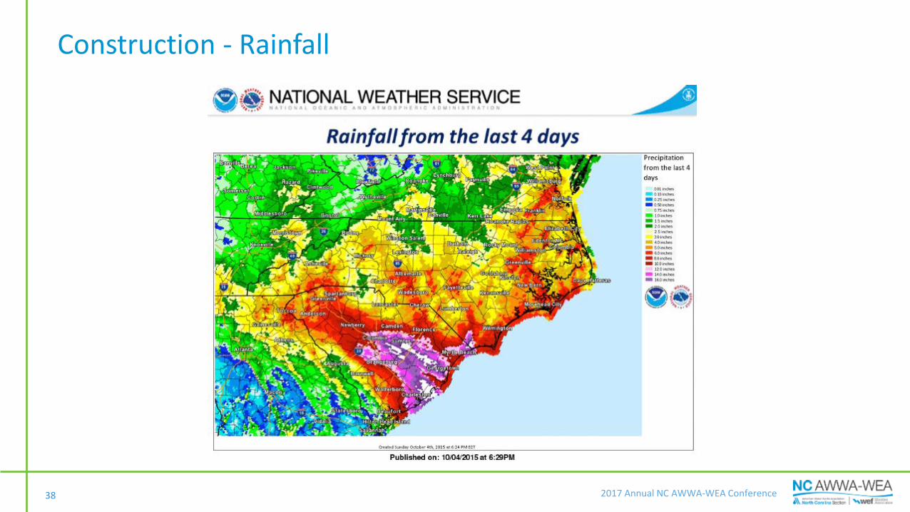
Construction - Rainfall
38

2017 Annual NC AWWA-WEA Conference
Construction – Major Storm Event• Thursday, October 1, – 3/8 inch of rain overnight, lake levels El. 102, drizzle• Friday, October 2, 7AM – 3/4 inch of rain overnight, lake levels at El. 104, light rain• Friday, October 2, 1PM – 5/8 inch of rain since 7AM, lake levels at El. 104, light rain• Friday, October 2, 8PM – 2 inches of rain since 7AM, lake levels at El. 104, steady rain• Friday, October 2, 11PM – 2-7/8 inches of rain since 7AM, lake levels at El. 105, steady rain• Saturday, October 3, 7AM – 2-1/2 inches of rain overnight, lake levels at El. 113, light rain
39

2017 Annual NC AWWA-WEA Conference
Construction – Major Storm Event
• Peak lake level El. 114, 3 feet below cofferdam crest
40

2017 Annual NC AWWA-WEA Conference
Construction – Mitigation Measures Implemented: Waters Recede
41

2017 Annual NC AWWA-WEA Conference42
Construction – Mitigation Measures Implemented: Waters Recede

2017 Annual NC AWWA-WEA Conference
Construction –Spillway Construction Completion
43

2017 Annual NC AWWA-WEA Conference
Construction – Diversion Pipe• Diversion Pipe Removal and Backfilling Around Spillway
44

2017 Annual NC AWWA-WEA Conference
Construction – Upstream Slope
• Upstream Slope Stabilization with Articulating Concrete Blocks
45

2017 Annual NC AWWA-WEA Conference
Construction – Parapet Wall Construction
46

2017 Annual NC AWWA-WEA Conference
Construction – Parapet Wall Construction
47

2017 Annual NC AWWA-WEA Conference
Construction Completion April 2016
48

2017 Annual NC AWWA-WEA Conference49
Parapet Wall and ACBStraight-Drop
Spillway
Construction Completion April 2016

2017 Annual NC AWWA-WEA Conference
Post-Construction Performance
50
• Hurricane Matthew, October 7 through 8, 2016• 15 inches of rain fell in
the project area in less that 24 hours
• Severe flooding and failure of several dams and levees occurred across all of eastern North Carolina

2017 Annual NC AWWA-WEA ConferenceHurricane Matthew – October 8, 2016, 3PM

2017 Annual NC AWWA-WEA Conference
100-year spillway engaged

2017 Annual NC AWWA-WEA Conference
View from the Crest – Upstream and Downstream
53

2017 Annual NC AWWA-WEA Conference
Post-Storm - Sunday October 9, 2016, 9 AM
