pre-miocene lithostratigraphy of taranaki basin, new zealand
TRANSCRIPT
This article was downloaded by: [Case Western Reserve University]On: 17 October 2014, At: 14:17Publisher: Taylor & FrancisInforma Ltd Registered in England and Wales Registered Number: 1072954 Registeredoffice: Mortimer House, 37-41 Mortimer Street, London W1T 3JH, UK
New Zealand Journal of Geology andGeophysicsPublication details, including instructions for authors andsubscription information:http://www.tandfonline.com/loi/tnzg20
Pre-Miocene lithostratigraphy ofTaranaki Basin, New ZealandJulie Palmer aa Petroleum Corporation of New Zealand (Exploration) Ltd ,P.O. Box 5082, Wellington , New ZealandPublished online: 28 May 2012.
To cite this article: Julie Palmer (1985) Pre-Miocene lithostratigraphy of Taranaki Basin,New Zealand, New Zealand Journal of Geology and Geophysics, 28:2, 197-216, DOI:10.1080/00288306.1985.10422220
To link to this article: http://dx.doi.org/10.1080/00288306.1985.10422220
PLEASE SCROLL DOWN FOR ARTICLE
Taylor & Francis makes every effort to ensure the accuracy of all the information (the“Content”) contained in the publications on our platform. However, Taylor & Francis,our agents, and our licensors make no representations or warranties whatsoever as tothe accuracy, completeness, or suitability for any purpose of the Content. Any opinionsand views expressed in this publication are the opinions and views of the authors,and are not the views of or endorsed by Taylor & Francis. The accuracy of the Contentshould not be relied upon and should be independently verified with primary sourcesof information. Taylor and Francis shall not be liable for any losses, actions, claims,proceedings, demands, costs, expenses, damages, and other liabilities whatsoeveror howsoever caused arising directly or indirectly in connection with, in relation to orarising out of the use of the Content.
This article may be used for research, teaching, and private study purposes. Anysubstantial or systematic reproduction, redistribution, reselling, loan, sub-licensing,systematic supply, or distribution in any form to anyone is expressly forbidden. Terms& Conditions of access and use can be found at http://www.tandfonline.com/page/terms-and-conditions
New Zealand Journal of Geology and Geophysics, 1985, Vo!. 28: 197-2160028-8306/85/2802-0197$2.50/0 © Crown copyright 1985
Pre-Miocene lithostratigraphy of Taranaki Basin, New Zealand
197
JULIE PALMERPetroleum Corporation of New Zealand (Exploration) LtdP.O. Box 5082Wellington, New Zealand
Abstract The stratigraphy and sedimentologyof the Paleocene-Oligocene sedimentary sequenceof Taranaki Basin is reviewed using data obtainedfrom exploration wells. Sixteen of these wells aresited in the Taranaki Graben, an infilled, downfaulted block extending westwards from the Taranaki Fault to the Cape Egmont Fault Zone. Afurther seven wells are sited on the Western Platform, which extends westwards from the CapeEgmont Fault Zone seaward to beyond the edge ofthe continental shelf.
In the past, the lithostratigraphic nomenclatureapplied to the sequences encountered in the wellswas adopted from adjoining onshore areas. Whereexisting names were inadequate, new names werecreated, but never formally defined.
The term "Kapuni Formation" is an informalname for the Paleocene-Oligocene sandstone-coalmeasure sequence which was first encountered inthe Kapuni-1 well. It is proposed that the thicksequence currently known as the Kapuni Formation be formally named the Kapuni Group. KapuniGroup is subdivided into four formations. Fromoldest to youngest they are Kaimiro Formation,Ornata Formation, Mangahewa Formation, andMcKee Formation. A lateral, fully marine equivalent of the Kapuni Group is described.
A further three formations are defined. TheWhaingaroan marine mudstone (Kaiata Formationof Shell BP and Todd Oil Services Ltd) is herenamed the Turi Formation; the Whaingaroan-Waitakian calcareous siltstone sequence informallyknown as the lower Mahoenui Group is named theOtaraoa Formation; and the Waitakian limestoneimmediately underlying the Mahoenui Formationproper is here named the Tikorangi Formation.
The stratigraphy of Taranaki Basin is comparedwith that of adjoining onshore areas to the northand south. Similarities are apparent and possiblenorthern and southern correlatives are proposed.
Received 22 July 1983. accepted 28 August 1984
Sig. I·
The environments of deposition of the variousunits range from bathyal to outer shelf throughinner shelf to lagoonal and terrestrial. Based onthese interpretations, a paleogeographic reconstruction of Taranaki Basin shows a major preMiocene transgression. It progressed across thebasin in a generally southeasterly direction. Theproximity of sediment source combined with atransgressive shoreline accounts for the diachronous nature of the lithostratigraphic boundaries.
Keywords Kapuni Group; Kaimiro Formation;Ornata Formation; Mangahewa Formation; McKeeFormation; Tikorangi Formation; Otaraoa Formation; Turi Formation; Matapo Sandstone Member;: new stratigraphic names; Taranaki Basin;paleoenvironment
INTRODUCTION
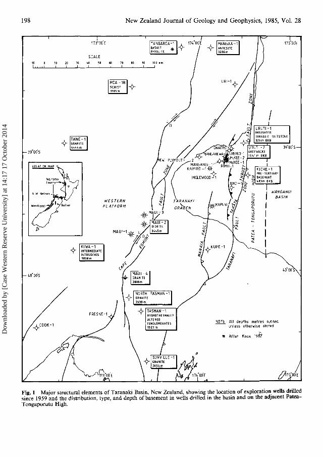
Taranaki Basin, which lies along the western sideof the North Island of New Zealand, is one of thecountry's largest sedimentary basins. It extendswestward from the Taranaki Fault Zone (Fig. I)and underlies the Taranaki peninsula and much ofthe adjacent continental shelf and slope (McBeath1976). The basin extends northwards from thenorthwest of the South Island to about the latitudeof Auckland (Pilaar & Wakefield 1978; Fig. 1).
Taranaki Basin contains a thick sequence of LateCretaceous-Recent sediments that overlie Paleozoic and early Mesozoic basement rocks. Isolatedoccurrences of pre-Miocene sediments crop out inthe basin, but most information on the oldest partof the sequence comes from wells drilled for hydrocarbon exploration and production. The first significant well was Kapuni-I, drilled in 1959 by ShellBP and Todd Oil ServicesLimited (SBPT). It drilledthe Kapuni Structure and discovered New Zealand'sfirst commercial gas-condensate field. Since 1959,a further 25 wildcat wells have penetrated the preMiocene sedimentary sequence. Of these, Maui-Idiscovered the offshore Maui gas-condensate fieldin 1969, and McKee-2 discovered the onshoreMcKee oil field in 1980. The three fields producefrom Paleocene-Oligocene sandstones of theKapuni "Formation". Other wells that penetratedthe Kapuni Formation contained some hydrocarbons. The most significant are.the onshore wellsMangahewa-1, Urenui-1, and McKee-I; and theoffshore well Maui-4 (Fig. 1).
Dow
nloa
ded
by [
Cas
e W
este
rn R
eser
ve U
nive
rsity
] at
14:
17 1
7 O
ctob
er 2
014
198 New Zealand Journal of Geology and Geophysics, 1985, Vol. 28
10 0 10 20 30 40 50 60 70 80 90 100 kmI , " , I I ! I I I I I I I ,
~
I
* After Knox 1961
NOTE All depths metres subsea-- unless otherwise stated
ji7S·00'E
~
~
WESTERNPLATFORM
173·00'E
FRESNE-1
SCALE
TANE-1GRANITE4444m
~
-¢-COOK-1
40·00'S
39"oo'S
Fig. 1 Major structural elements of Taranaki Basin, New Zealand, showing the location of exploration wells drilledsince 1959 and the distribution, type, and depth of basement in wells drilled in the basin and on the adjacent PateaTongaporutu High,
Dow
nloa
ded
by [
Cas
e W
este
rn R
eser
ve U
nive
rsity
] at
14:
17 1
7 O
ctob
er 2
014

Palmer-Pre-Miocene lithostratigraphy, Taranaki Basin 199
Many of the lithostratigraphic names applied tothe sequences encountered in Taranaki Basin wellswere adopted from adjoining onshore areas. In thepast, where existing names were inadequate, newnames were created, but never formally defined,and boundaries therefore were often vague. Theresulting stratigraphic nomenclature containeduncertainties and was often used inconsistently.This paper provides a lithostratigraphic nomenclature for the Late Cretaceous-Oligocene sediments,based on data gathered from exploration and production wells. Several new names are introduced.Hedberg (1976) has been followed in constructingthe nomenclature. The depository for material usedin this study (i.e. ditch cutting samples, cores andwell logs (Table 1)) is the New Zealand GeologicalSurvey, Lower Hutt. Unless stated otherwise, thedatum for all well depths is below kelly bushing(BKB).
STRUCTURE
Taranaki Basin is composed of two major structural blocks (Fig. 1), the Western Platform and theTaranaki Graben (Pilaar & Wakefield 1978; Knox1982). The Western Platform, over 100 km wide,is the western, wholly offshore part of the basin. Itis characterised by broad, simple structure and2000-5000 m of Late Cretaceous-Recent sediments. It was affected by Late Cretaceous-Eocenenormal block faulting, which created local faultangle depressions or half grabens (Pilaar & Wakefield 1978), but has been relatively stable throughout the remainder ofthe Tertiary. The north-southto northeast-southwest trending Cape Egmont FaultZone (Fig. 1) consists of a series of steep, subparallel, normal to reverse faults (McBeath 1977);maximum throw is 2100 m.
The north-south trending Taranaki Fault Zone(Fig. 1) consists of a narrow zone of steep reversefaults that become nearly vertical and normal withdepth (Pilaar & Wakefield 1978). The zone wasdownthrown on the western side, resulting in theaccumulation of a thick sedimentary sequence inthe adjacent graben. Several aligned, shallow thrustfaults are associated with the Taranaki Fault. Theycomprise the Tarata Thrust Fault Zone (Haskell1981) (Fig. 1). Vertical throw along the TaranakiFault Zone is estimated to be 7000 m (McBeath1976), and the top of the Kapuni Formation adjacent to the fault is at least 5000 m below sea level.East of the Taranaki Fault lies the Patea-Tongaporutu High, an upthrust basement block whichseparates Taranaki Basin from the late CenozoicWanganui Basin to the east (Fig. 1).
The overall structure of the Taranaki Graben iscontrolled by movement along basement and Late
Cretaceous-Eocene faults. From Late Eocene to atleast Late Miocene time, folding in the grabenoccurred contemporaneously with deposition. Several generally north-south trending anticlines occur.Their extended growth is evidenced by thinning ofthe sedimentary sequence at the crest of each.Examples include the Kapuni, Maui, Inglewood,Kaimiro, Mangahewa, and Kupe Structures.
BASEMENT
Basement rocks crop out in northwest Nelson andeast of the Taranaki Basin in Waitomo County.Basement has only been encountered in wellsdrilledoffshore. The nature of basement varies from wellto well (Fig. 1). Two wells in the northern part ofthe basin, Mangaa-l and Tangaroa-I, encounteredandesitic and basaltic lavas. Although these rocksmay not be true basement, they obscured theunderlying rocks and, at the time of drilling, wereconsidered economic basement. In Moa-l B, schistose basement was encountered. Further south,basement is a granite-diorite suite of rocks. Theproven depth to basement ranges from 4444 mbelow sea level in Tane-l, in the northwest Taranaki Basin, to 1521 m below sea level in Tasman1, in the South Taranaki Basin. There is a generalsouthward shallowing of basement and, onshore innorthwest Nelson, granite and schist crop out atthe surface.
Basement rocks have not yet been drilled in theonshore Taranaki Graben. Seismic data indicatethat, in the deepest parts of the graben, the sedimentary cover may be as thick as 7000 m.
STRATIGRAPHY
The surface geology of the Taranaki peninsula isdominated by Recent volcanics (Hay 1967; Neall1979), which mask the Upper Cretaceous-Recentsedimentary sequence. Hay (1967)and Neall (1979),and Bishop (1971), map the stratigraphy of the outcropping basin sequence for onshore Taranaki andnorthwest Nelson, respectively. However, theextent, nature, and age of the underlying sedimentswas unknown before wells were drilled. Severalauthors refer to, and briefly describe, the subsurface stratigraphy (Short 1962;McBeath 1976, 1977;Pilaar & Wakefield 1978; Hill & Collen 1978;Hogan 1979). Of these, Short (1962) gives the mostcomplete presentation.
This paper presents the results of a detailed studyof the pre-Miocene stratigraphy of Taranaki Basinand revises the stratigraphic units. New names areproposed for the Oligocene, Eocene, and Paleocene
Dow
nloa
ded
by [
Cas
e W
este
rn R
eser
ve U
nive
rsity
] at
14:
17 1
7 O
ctob
er 2
014

Tab
le1
Sum
mar
yo
fda
taav
aila
ble
from
type
sect
ions
",tv 0
Lit
host
rati
grap
hic
Typ
eIn
terv
alA
geL
ithol
ogy
Wel
llo
gs0
unit
loca
tion
(mB
KB
)t(r
efer
ence
)(r
efer
ence
)Sa
mpl
esov
erty
pese
ctio
n
Kai
mir
oF
orm
atio
nIn
glew
ood-
I46
33-5
061
Dh
orol
der
San
dsto
new
ithoc
casi
onal
Dit
chcu
ttin
gSo
nic;
(Mci
ntyr
e&
inte
rbed
so
fsi
ltysa
mpl
esev
ery
Gam
ma
ray-
neut
ron;
Nor
ris
1966
;m
udst
one
(Ger
lings
&va
n3
m.
Dip
met
er(p
arti
alH
ayw
ard
etal
.de
rA
beel
e19
64).
cove
rage
);19
82)
Mic
rolo
g;O
rnat
aF
orm
atio
nIn
glew
ood-
I46
16-4
633
Dm
-Dh
(Mci
ntyr
eD
ark
brow
nsa
ndy
Dit
chcu
ttin
gIn
duct
ion
-&
Nor
ris
1966
;si
ltst
one
and
mud
ston
esa
mpl
esev
ery
elec
tric
al;
Hay
war
det
al.
(Ger
lings
&va
nde
r3
m.
Spo
ntan
eous
1982
)A
beel
e19
64).
pote
ntia
l;M
anga
hew
aF
orm
atio
nIn
glew
ood-
I37
42-4
616
Dp
-Ar
(Mci
ntyr
eIn
terb
edde
dsa
ndst
one,
Dit
chcu
ttin
g&
Nor
ris
1966
;si
ltst
one,
mud
ston
ean
dsa
mpl
esev
ery
Hay
war
det
al.
coal
(Ger
lings
&va
nde
r3
m.
1982
)A
beel
e19
64).
Ico
nven
tion
alco
reZ
(451
0-45
14.5
m).
"" ~M
cKee
For
mat
ion
McK
ee-3
A21
30-2
220
Ar-
Lw
h(H
ayw
ard
San
dsto
new
ithoc
casi
onal
Dit
chcu
ttin
gD
ipm
eter
;D
ensi
ty~
(AH
)t&
Mil
denh
all
mud
ston
ecl
asts
and
sam
ples
ever
y-
neut
ron;
Dua
lS-
1980
;H
ayw
ard
inte
rbed
ded
calc
areo
us3
m.
late
rlog
-:::
l19
82)
sand
ston
e(P
alm
er&
6co
nven
tion
alm
icro
resi
stiv
ity;
c,
Bea
rdm
an19
83).
core
sS
pont
aneo
us..... 0
(213
1-22
23.5
m).
pote
ntia
lga
mm
a~
ray;
Indu
ctio
n;:3
Soni
ce:- o
Tur
iF
orm
atio
nM
anga
hew
a-I
3472
-347
9L
wh
(Hog
an19
79)
Bro
wn-
grey
tom
ediu
mda
rkD
itch
cutt
ing
Indu
ctio
n-
....,gr
ey,
slig
ht1y
tosa
mpl
esev
ery
elec
tric
al;
0 ""no
ncal
care
ous,
mic
aceo
us3
m.
Spo
ntan
eous
0 0-m
udst
one
(van
Rije
n&
van
Ico
nven
tion
alpo
tent
ial
(JQ
der
Abe
ele
1963
).co
re'< P
>(3
472-
3475
m).
:::l
Ota
raoa
For
mat
ion
Man
gahe
wa-
I32
50-3
472
Lw
h-L
wG
rey,
very
calc
areo
us,
Dit
chcu
ttin
gc,
(Mat
apo
San
dsto
ne(3
464-
3472
)(C
ope
1963
)si
ltym
udst
one.
Ver
ysa
mpl
esev
ery
0 ""M
embe
r)gl
auco
niti
cba
sal
3m
.0 'tl
sand
ston
e(v
anR
ijen
&va
n::r '<
der
Abe
ele
1963
).'"
Tik
oran
giF
orm
atio
nM
anga
hew
a-I
3213
-325
0L
wB
lue-
grey
sand
yli
mes
tone
,D
itch
cutt
ing
('i'
J"(C
ope
1963
;ca
lcar
eous
sand
ston
ean
dsa
mpl
esev
ery
Mci
ntyr
e19
62)
whi
tecr
ysta
llin
e3
m.
'0 00
lim
esto
new
ithca
lcar
eous
~Vl
mud
ston
e(v
anR
ijen
&va
n<
:de
rA
beel
e19
63).
?- tv*D
epos
itor
yfo
rm
ater
ial
isN
ewZ
eala
ndG
eolo
gica
lSu
rvey
,L
ower
Hut
t;tB
KB
=M
etre
sbe
low
kelly
bush
ing;
*AH
=A
long
hole
belo
wke
llybu
shin
g(M
cKee
00
3Ais
ade
viat
edw
ell)
.
Dow
nloa
ded
by [
Cas
e W
este
rn R
eser
ve U
nive
rsity
] at
14:
17 1
7 O
ctob
er 2
014
Palmer-Pre-Miocene lithostratigraphy, Taranaki Basin 201
LITHOLOGIC
LEGEND
1=;= =;=1 SHALE
r:TlINTERBEDDED~ SEQUENCE
§COAL
D CARBONACEOUS
g LIMESTONE
1 = ICALCAREOUS
G GLAUCONITIC
EJMICA
G FORAMINIFERA
[~ul UNCONFORMITYo DISCONFORMITY
1~:~::ii~/21 SANDSTONE
I~':: JSANDY LITHOLOGY
I~:: :::: ~I SILTSTONE
n JSILTY LITHOLOGY
[-_- -j ARGILLACEOUS- - LITHOLOGY
interbeddedsandstonesi Itstcne ,mudstoneand coal
lnterbeddad sandstone , occasionally~~~~.lomerQtic, siltstone, mudstone and
Silty mudstone with occasionalcalcareous streaks.
LITHOLOGY
Predorninuntly lirnestone with abQ5Q.1 sandstone.
Int.rb.dd.dsi I tstone,si l tysandstoneandsiltymudstone.
Calcareous siltstone DAd mudstone with °1 Dbasal glauconihc sandstone.IMatuposst. rnbr.l -s- MUDSTONE
Nonca(cQreous carbonaceous mudstone
Calcareous mudstone, siltstoneand sandston.
Silty mudstone with minor conqlcrnerute.
Sandstone. ercnsionnllv crniltnceeus
Interbedded siltstone and mudstone.
Volcanics and clastic sediments.
Silty mudstone
Sandy, silty mudstones interbedded with
l\quartz ose conglomerates, with occasionalthin lignit. beds.
o,::::>a0::'-"
FORMATIONI Z::::>c,«~
KAIMIROFORMATION
MCKEEFORMATION/
TURI FORMATION
PAKAWAU GROUP
FORMATIONnCOl"'lC'ITC'
,,,,,~;;;t fORMATION
cin
~ MANGAHEWA~ FORMATION
~
ic:
MOKAU GROUP
URENUI FORMATION
TANGAHOE FORMATION
·.TEMATEAONGA FM.
MOHAKATINO GROUP
.. :'l- I I
......
'..~: .1-:': .... .:
.·.·.·10.
.. \ .. :1'1 g,T •. .-:::-: ~
::r. 0.0::. ~
I•• ::::E:'\ ••• o.
.. ···l"':::::·~ z §•• " :::::> .&.
Cl."t:« 0
~~
T·· l-.... Z
w--':;::::>.. 8
TIKORANGI FORMATION
• 001 T
·~:"1<:1 I MAHOENUI GROUPI• · • ·· :r=.... ..
o
•• T
•• 0 0
--'a
~ It~~.J.~~~1 OTARAOA FORMATION
'-" -
Wi···)·····,~ ::~::.:~::::--' TI
~
WI'z:.. ~W ••LJ ••
a TE ..
[Dt: .: ..,
Vl ••••• .::::> '" ."aWLJ
i5W0::LJ
EPOCH
I I:: '~'.
......".UJ .0' •
I«--'
.; 0"10001 aT
Fig.2 Summary of the stratigraphy of the Cretaceous-Recent sedimentary sequence deposited in Taranaki Basin,New Zealand.
Dow
nloa
ded
by [
Cas
e W
este
rn R
eser
ve U
nive
rsity
] at
14:
17 1
7 O
ctob
er 2
014
.,,
z~
I
~~
~«
~NE
WZE
ALA
ND
.,""'.,
~.,
is~~,
i!ST
AGES
~~
j~~"1
I~r;-'
Z~
'I~~
=>~
~C
DI
g~
~~
§~
~~~
~~
L3~
~~~
~~
g~
uu.
Vl
I--
Z~
:EL
z;::.::
::~
~I-
:E~::>
ZI-
:l:I-
OTA'
AN".,
"""'+
","oJ""
,Ih
-"J
""W
AITA
KIAN
(L"I
TAK1
AKA
Ih
YI-
---+
----
--'
DU
NTR
OO
NIA
N(L
d)
TIKO
RAN
GI
ABEL
AB
EL
OTA
RAO
AO
TAR
AOA
TIK
OR
AING'W
HAI
NG
ARO
AN(L
"hl
HEA
DHT
EAD
IT
UR
IF
RU
NAN
GAN
(Arl
MO
TUPI
PIT
UR
IM
eW
TU1R
I
COAL
MEA
SUR
ESJ
NOD
EPO
SITI
ON
MCK
EEI
IKA
IATA
N(A
klM
ANG
AHEW
AM
ANG
AHEW
A
1I42
86m
IK
AP
UN
IG
ROUP
f---
-.,.
....
-.,.
.,J
BORT
ON
IAN
(Ab
lN
OD
EPO
SITI
ON
'--
1--
..L
.-r-
r....
..'--'
39
00
mEQ
UIV
ALEN
T3914m~4900m,
OM
ATA
IT
UR
IP
RAN
IAN
IOn
KA
PU
NI
OM
A44
51m
HtR
ETAU
NiA
NO
h,G
RO
UP
KA
IMIR
OL-
44~0
9:S5;;;-m--i-_
_--1
__
..,P
AN
Om
Jr-r
-50
61m
WAI
PAW
AN10
"1
KA
PU
NIG
RO
UP
3684
mEQ
UIV
ALE
NT
TEU
RIA
NlO
t)I
PAKA
WAU
'----.,J.-.~-r--__t---i
"AU
MU
RIA
N,..,
''''1'"1
,,;;;;;-
"'']''
2694
m2
50
3m
3511
m
,0
BA
SE
M(N
T[l
]rn-
-BASE
ME
NT
Sca
leB
AS
EM
EN
T
.'[)
2'20
2m16
30m
2727
m39
19m
3566
m20
020
4060
8010
012
{)14
016
0km
35
46
m45
39m
I,I
II
II
II
II
Fig
.3C
ompa
riso
no
fpr
e-M
ioce
nest
rati
grap
hyen
coun
tere
din
wel
lsdr
illed
inT
aran
aki
Bas
in.
The
wel
lsar
epo
siti
oned
geog
raph
ical
lyfr
omso
uth
(lef
t)to
nort
h.D
ista
nce
betw
een
wel
lsis
tosc
ale.
The
loca
tion
of
each
wel
lis
show
non
Fig.
I.F
deno
tes
top
McK
eeF
orm
atio
nfa
ulte
dou
t.
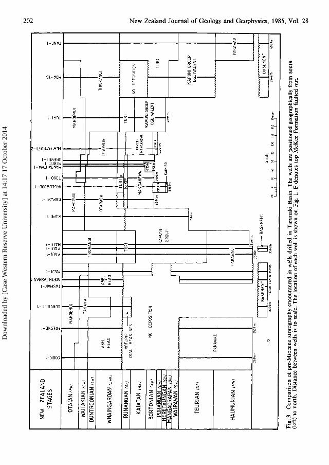
N o N ~ ~ ~ Q.. ..... o 8 a o ..., ~ ~ § Q.. ~ t SA .... \0 00
Y' ~ N 00
Dow
nloa
ded
by [
Cas
e W
este
rn R
eser
ve U
nive
rsity
] at
14:
17 1
7 O
ctob
er 2
014
Palmer-Pre-Miocene lithostratigraphy, Taranaki Basin 203
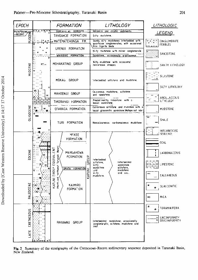
rocks (Fig. 2). The units are defined by lithologicalchanges determined from well data and theirrespective log responses. Some of the lithostratigraphic units are diachronous (Fig. 3) and relategeographically to environments of deposition. Inparticular, I propose to elevate Kapuni Formationto Kapuni Group, consisting of four formations.Application of the name Mahoenui Group asdefined by Glennie (1956) and Kear & Schofield(1959) necessitates erection of three additional stratigraphic units, the Tikorangi, Otaraoa, and TuriFormations, which were erroneously included inMahoenui Group. A fully marine, lateral equivalent of the Kapuni Group is described for rockspenetrated in offshore wells in the north and northwest part of the basin (Fig. 3).
PAKAWAU GROUP (Bishop 1971)
The oldest sedimentary rocks known in TaranakiBasin belong to the Pakawau Group. This Cretaceous-Paleocene conglomerate, sandstone, and coalmeasure sequence, which crops out in the northwest of the South Island, was encountered in offshore wells Cook-I, Fresne-l, North Tasman-I,Maui Field, Maui-4, and Tane-l (Fig. 3).
Field and seismic evidence indicate that deposition of Late Cretaceous and early Tertiary rockswas largely structurally controlled. The thickestsequences of these rocks occur in fault-angledepressions formed by tilted basement blocks. Somewells have drilled more than 2000 m of PakawauGroup rocks without reaching the base of thesequence.
The Pakawau Group rests on an erosion surfacewhich truncates igneous and metamorphic basement rocks (Pilaar & Wakefield 1978). It also cropsout in the northwest of the South Island, and theunit is widely distributed over the Western Platform and southern Taranaki Graben, but has notyet been encountered in the central or northern partof the graben.
In the south, both onshore and in the Fresne-land Cook-l offshore wells, Pakawau Group consists of a basal conglomeratic coarse sandstoneoverlain by alternating sandstone, mudstone, andcoal. Northwards the sequence is more uniform,consisting of fine- to coarse-grained sandstones withthin beds of mudstone and coal.
KAPUNI GROUP (new name)
Kapuni Formation is a convenient name which hasbeen applied to coal measures of Paleocene-EarlyOligocene age encountered in wells drilled in Taranaki Basin. These rocks were first encountered inKapuni-l and were correlated (van der Klugt et al.
1959) with an outcrop of similar strata in NorthTaranaki (the Mangaotaki Formation of Glennie(1956)). The Mangaotaki Formation consists ofOligocene sandstone (including glauconitic and calcareous sandstone), siltstone, coal, mudstone, andconglomerate found in the predominantly calcareous sandstone facies in North Taranaki. In comparing the Eocene-Paleocene Kapuni coal measureswith the type section of the Mangaotaki Formation, Short (1962) noted a difference in lithology,thickness, and age. He, therefore, proposed thename Kapuni Coal Measure Formation, morecommonly referred to as the Kapuni Formation.In a study of the stratigraphy and sedimentology,Hogan (1979) divided the Kapuni Formation intofour members, the boundaries of which weredefined from the Kapuni-l well, but which provedto be impractical for correlation elsewhere in Taranaki Basin.
Different correlatable subdivisions within theKapuni Formation subsequently were recognisedover much of the Taranaki Basin, and this paperproposes that the Kapuni Formation be elevatedto group status. In descending order, the upper partof the Kapuni Group consists of the McKee andMangahewa Formations (defined below) and thelower part consists of the Omata and Kaimiro Formations (defined below). Type sections for theseformations are located in the eastern and centralTaranaki Graben, where the greatest density of welldata is available. The units are correlated westwardon the available well data.
The top of the Kapuni Group is marked by amajor sedimentation change at the top of theMcKee Formation boundary where the lithologychanges from a sandstone to a massive silty mudstone. The McKee Formation, consisting predominantly of sandstone beds, has been encountered inwells located in the eastern and central TaranakiGraben. Immediately underlying this unit is a coalmeasure sequence, here formally named the Mangahewa Formation.
The distribution and lateral changes within thelower part of the Kapuni Group are not as wellknown as those of the upper part of the KapuniGroup. A sequence of marine siltstone and mudstone encountered onshore (in Inglewood-l andKaimiro-l wells and probably in the Kapuni-2 andNew Plymouth-2 wells) is here formally named theOmata Formation, and an older sandstone-mudstone sequence, the lowermost known unit of theKapuni Group, is here formally named the Kaimiro Formation.
Kapuni Group rocks occur across the TaranakiBasin. The majority of onshore wells drilled theupper part of the Kapuni Group, and several wellsdrilled the lower part of the group, but none of
Dow
nloa
ded
by [
Cas
e W
este
rn R
eser
ve U
nive
rsity
] at
14:
17 1
7 O
ctob
er 2
014

204 New Zealand Journal of Geology and Geophysics, 1985, Vol. 28
HORIZONTAL SCALE
10 3919m17)' 00' E
I
Fig. 4 Stratigraphiccolumns showing thethickness and distribution of pre-Miocenesequence in TaranakiBasin. Total depthsare shown in metresbelow kelly bushing(m BKB).
39'oO'S
1:::·:.;.:·::::3 ABEL HEAD
0· KAPUNI GROUP.. EOUIVA l ENT
CD PAKAWAU
IJ!nJ] BASEMEN
f fAULlU UNCONf ORM ITY
Ul v -.
0' L;?,; TO 397Lm
,"~K~~e~ 1- . . -
.. : . U
TO3~82 m
,~B
Mongohewo:'1
1< _» >1MCKE E
CII MANGA~EWA
t) :-J O"'ATA
ELl KAI MI RO
174 00' E
New Plymouth -2
Formotlon ~g~
17400' E
I.: :..: JMAHO~N UI
~ TlKORAN(j1
o OTARADA
F:=:j TURI
~ KA PUN I GROUP
T 0 35L6 ..
A~~ ,
MB~O - 'B -!r
A
~ .~ .~ I ur i - 1/
..- -
SOkmLO3020
173" 00' E
T O l.5 39m
TO 3858 ..
c-i,K1,WO-'
. . . ..~~ . :-::.:,~
1000..I
1M;[:;t
:t!:! l-1 00 0",
'"~
~10
LO'OO'S
B-i _
3( \ rone - 100 S t'4.::1
A:Tur i - , Mongohewo -1 Ko punl-1
0'Kupe- '
KAP UNIHCKee
Mohoenui
GROUP
Oto rooo
Mo ngahtwo
MahoenUI
KapUni r.r .,up Equivotent
Dow
nloa
ded
by [
Cas
e W
este
rn R
eser
ve U
nive
rsity
] at
14:
17 1
7 O
ctob
er 2
014
Palmer-Pre-Miocene lithostratigraphy, Taranaki Basin
AMoa-1B
205
ATuri-1
OTAIAN pn MahoenuiLATE WAITAKIAN LLwEARLY WAITAKIAN e LwDUNTROONIAN Ld Tikorangi
WHAINGAROAN LwhRUNANGAN Ar
~Turi
KAIATAN AkBORTON IAN AbPORANGAN - HERETAUNGAN Do- DhMANGAORAPAN - WAIPAWAN Om-Dw Kapuni Group Equivalent
TEURIAN DIHAUMURIAN Mh ? ?
Rn~pinpn .
BTane-l
B'New Plymouth-Z Mangahewa-l
PoLLwe LwLd
Mahoenui
TikorangiOlaraoa
c
LwhArAkAb
Do-DhDm-DwDtMh
Kiwa-l Maui -2
~MCKee
Mangahewa.... -'--_Omatci
Kapuni-2c'
Toko-l
PoITweLwLdLwhArAi<Ab
DP-DhDm-DwDtMh
Til<orangi
KAPUNIGROUP
PakawauBusernent
oMaui-4
Kaimiro
Otaraoa Tikorangi
0'Kupe-l
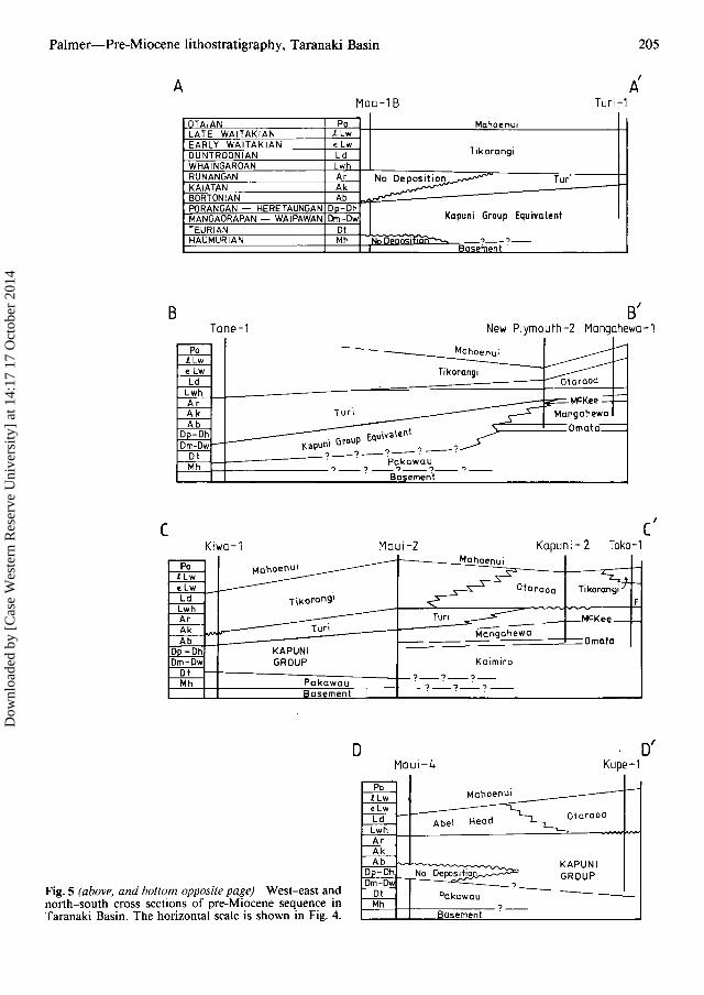
Fig. 5 (above, and bottom opposite page) West-east andnorth-south cross sections of pre-Miocene sequence inTaranaki Basin. The horizontal scale is shown in Fig. 4.
Abel Head
No Deposition.~
Pakawau
Basement
Oloraoa
KAPUNIGROUP--
Dow
nloa
ded
by [
Cas
e W
este
rn R
eser
ve U
nive
rsity
] at
14:
17 1
7 O
ctob
er 2
014
206 New Zealand Journal of Geology and Geophysics, 1985, Vol. 28
these wells have penetrated the base of the group.On some seismic records in the graben, acousticbasement reflectors occur at about 4 s two-way-time(TWT) which represents some 7000 m of sedimentary section. Several offshore wells have drilledthrough the Kapuni Group into the underlyingsequence, which is correlated with the PakawauGroup of northwest Nelson.
Jonkers et al. (1969) recognised Kapuni Grouprocks in the Maui-I well. Later, several correlatablehorizons were identified in the Maui Field and thesewere given informal names (Jonkers et al. 1970;McBeath 1977): the CI to C3 sands and C2 andC3 shales correlate with the upper part of theKapuni Group; the 01 shale correlates with theOrnata Formation.
Distribution of Kapuni Group rocks (Fig. 3) ismore regular than that of the older Pakawau Group.Their deposition was predominantly structurallycontrolled. The sequence is thickest in the centralTaranaki Graben and becomes thinner southwardsand westwards (Fig. 4, 5). The thickness, lateralcontinuity, and nature of the sediments comprisingthe Kapuni Group suggest that during Paleoceneand Eocene times large areas ofthe basin were subsiding contemporaneously with deposition.
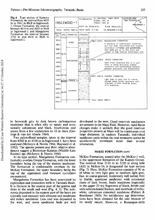
KAIMIRO FORMAnON (new)
Kaimiro Formation, named after the North Taranaki township of Kaimiro, is the lowermostrecognised formation of the Kapuni Group. It con.sists predominantly of sandstone with interbeddedsiltstone and mudstone.
The interval from 4633 m to 5061 m BKB (totaldepth) in Inglewood-1 is designated the type section (Fig. 6). Here the formation consists of 428 mof light grey to grey, fine- to occasionally coarseor very coarse-grained, poorly to moderately sorted,generally hard, in part argillaceous, in part calcareous sandstone with interbeds of dark blackishbrown, silty, sandy, micaceous, in part carbonaceous mudstone (Gerlings & van der Abeele 1964).The sequence is unfossiliferous. However, agesestablished for the overlying Ornata Formation(defined below) indicate a Heretaungan or older agefor the Kaimiro Formation (Mcintyre & Norris1966; Hayward et al. 1982).
The upper contact of the formation is conformable with the overlying Ornata Formation. OnshoreInglewood-I, Kaimiro-I, and possibly Kapuni-2reach the Kaimiro Formation, but they terminatein it, and the nature of the basal contact and of theunderlying sequence therefore is unknown. Offshore, the lower part of the Kapuni Group has beenpenetrated (e.g., in Maui-4) and it conformablyoverlies the Pakawau Group. In the Maui Field,
the oldest producing sequence is sandstones withinthe Kaimiro Formation in the lower part of theKapuni Group. To date, this is the only locationwhere hydrocarbons are being produced from thelower part of the Kapuni Group.
OMAT A FORMAnON (new)
Ornata Formation, named after the North Taranaki township, consists of mudstone and siltstone,considered to be marine, and overlies the KaimiroFormation.
The interval from 4616 m to 4633 m BKB inInglewood-1 is designated type section (Fig. 6). Itconsists of 17 m of dark brown, sandy, slightly calcareous, slightly carbonaceous, in part glauconitic,silty, sandy, fossiliferous mudstone (Gerlings & vander Abeele 1964). Foraminifera, palynoflora, andmicroplankton from 4633 m indicate a Mangaorapan-Heretaungan age (Mcintyre & Norris 1966;Hayward et al. 1982).
The lower boundary of Ornata Formation is conformable with the Kaimiro Formation. The upperboundary is conformable with the MangahewaFormation. Few wells have drilled the Ornata Formation and its distribution is therefore poorlyknown (Fig. 4, 5). The Heretaungan-Bortonianmudstone penetrated in the Maui Field (informallycalled the D1 shale) (Jonkers et al. 1969) is similarin age and lithology and is here correlated with theOrnata Formation. This mudstone is the cap rockof the lower part of the Kapuni Group reservoir inthe Maui Field. In Kapuni-2, the mudstone from3932 m to 3941 m is tentatively identified as OrnataFormation, and the New Plymouth-2 well terminated in the Ornata Formation. These correlationsare based on faunal and lithological comparisons.
MANGAHEWA FORMAnON (new)
Mangahewa Formation, named after the Mangahewa-1 well, consists of a thick sequence ofinterbedded sandstone, siltstone, mudstone, andcoal. This, the lowermost formation. of the upperpart of the Kapuni Group, occurs wiffely across thebasin and is one of the primary exploration targetsin the basin.
The interval from 3742 m to 4616 m BKB inInglewood-1 is designated the type section (Fig. 6).Here, Mangahewa Formation consists of 874 m ofinterbedded fine- to occasionally coarse-grained,white to light brown to light grey to grey, poorlyto moderately well sorted, angular to subrounded,quartzose, in part calcareous, in part friable, occasionally glauconitic sandstone with fine argillaceous and carbonaceous laminae; occasional darkbrown, sandy, micaceous siltstone; light bluish grey
Dow
nloa
ded
by [
Cas
e W
este
rn R
eser
ve U
nive
rsity
] at
14:
17 1
7 O
ctob
er 2
014
Palmer-Pre-Miocene lithostratigraphy, Taranaki Basin 207
Fig.6 Type section of KaimiroFormation, thc interval from 4633m to 5061 m BKB in InglewoodI ; Ornata Formation, the intervalbetween 4616 m and 4633 m BKBin Inglewood-I : and MangahcwaFormation, the interval between3742 m and 4616 m BKB inInglewood-L
CO-ORDINATES' N.I NATIONAL YARD GRID LOCATION M~373264 YOS N N." Plymout ~
INGLEWOOD -1 176 S31 YOS E.
HEV. Gl 310 m A.S L. R K.B. 316 m A5L . 1NGC:'
TOTAL DEPTH 506 1 m SPUD DATE 14·1· 63 1 0 . REACHEO 3 3·63
DEPTHAG ~ FORMATION LITHOLOGY
Im lr--
/\ "3700 ~ . :w v.;.
/314 1- 4616", MANGAHEWA FORMATIONH<KEE
3800H:KC:' ~
A seq ve oce of CQrbol'\Qe~u~ mud~tOf'lt·5
ol'\d cool eees ln tt"rcolott"d ..... Ith slig htlycc reereeus siltst ones a nd sand ston es .
3900 I I Cool beds Off up to 'Om th ick Of\dconsis t of high Yolat ile bituminou, ( 0'11.
4000 Ak-Ar ~ I ,
4100::;:;::::1 .1~MANGAHEWA 46 16 - ~ 6 33 m OMAlA fORMATION
420l>- . Ir I Dar k brown mudstone that is In part
I .: ..1.si lt y or sondy . mirac lP ous , sli ghtly
4300 calcar eous Qnd CQrbonouous : contai ns
- J__ 'J globular glaucon ite Qnd foraminife ra4400
4500 Ab-Ak:::.- ~. ~ .: .:" :-::-:r:"'"'' ,,,,,,ro,
4600 1~
.:';::. -:::".:::::::.:'; li ght gre y fa qrey . 'In e to eeer segra ined, poorl) sor red sandsron e wi rh
4700
IIm~:"" 7~I nter beds of dark blac kISh bro wn,silty mudst one
L800KAIMIRO It(~ -
4900 Ow-Oh
H? ~SOOO I :\?i~:{)
Toio l O.pth 5061",5100
to brownish grey to dark brown carbonaceousmudstone that is often silty or sandy and occasionally calcareous; and black, bituminous coalseams from a few centimetres to 10 m thick (Gerlings & van der Abeele 1964).
Two palynofloral samples, taken in the intervalfrom 4368 m to 4538 m in Inglewood-l , have beenanalysed (Mcintyre & Norris 1966; Hayward et al.1982). The species present and their relative abundances suggest a Bortonian-Kaiatan (Middle-LateEocene) age (Mcintyre & Norris 1966).
At its type section, Mangahewa Formation conformably overlies Ornata Formation , with the lowerboundary being the top of the marine mudstone.The formation is conformably overlain by theMcKee Formation, the upper boundary being thetop of the uppermost coal measure cyclothemencountered.
Mangahewa Formation has been penetrated byexploration and production wells in Taranaki Basin.It is thickest in the eastern part of the graben andthins to the south and west (Fig. 4, 5). The sediments deposited in the eastern part of the basin aretypically coal measure with siltstone and mudstoneand minor sandstone. Less coal was deposited inthe west, and some sandstone beds are well
developed to the west. Good reservoir sandstonesare present in the Maui Field. However, rapid facieschanges make it unlikely that the good reservoirproperties present at Maui will be continuous overlarge distances. In onshore Taranaki, individualsandstone units within the coal measures cannot besatisfactorily correlated more than severalkilometres .
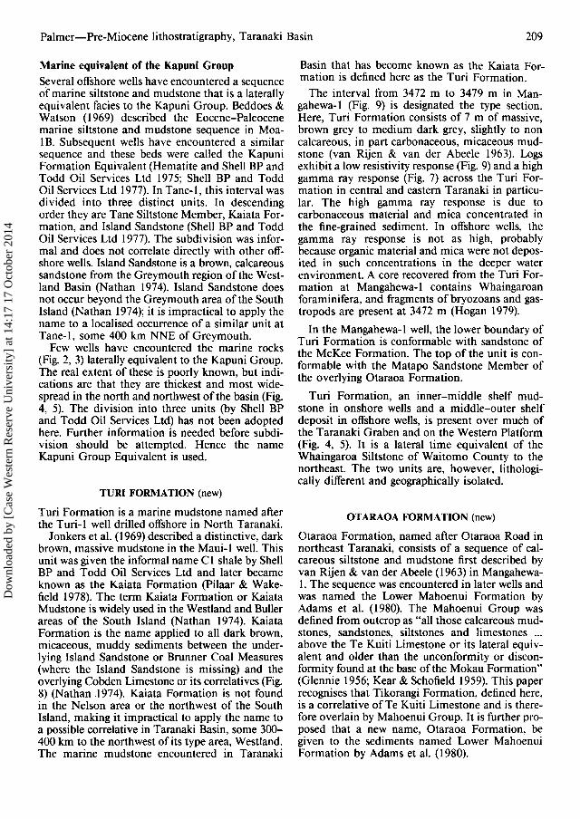
McKEE FORMATION (new)
McKee Formation, named after the McKee-I well,is the uppermost formation of the Kapuni Group.The interval from 2130 m to 2220 m along hole(AH) in McKee-3A is designated the type' section(Fig. 7). Here, McKee Formation consists of 90 mof white to very light grey to medium light grey,fine- to coarse-grained, moderately well sorted, firmto friable, quartzose sandstone with occasionalclasts of dark brown, fissile mudstone (especiallyin the upper 20 m), fragments of black, brittle coalwith subconchoidal fracture, and interbeds of milkywhite, calcareous cemented sandstone (Palmer &Beardman 1983). No satisfactory age determinations have been obtained for the unit because ofits sandy nature. However, a Runangan-early
Dow
nloa
ded
by [
Cas
e W
este
rn R
eser
ve U
nive
rsity
] at
14:
17 1
7 O
ctob
er 2
014

208 New Zealand Journal of Geology and Geophysics, 1985, Vol. 28
LATITUDELONGITUDEMcKEE-3A
TOTAL DEPTH 2250 m
COORDINATES:
ELEV GL. 150m A.SL.SPUD DATE 18 - 11- 81
39 0 05' 45" S174 0 19' 59" E
R.K B. 160m A.SL.TO. REACH ED 14-12 -81
New Plymout h
LOCATION MAP
NEUTRON DENSIT Y %30 LIMESTONE MATRIX 0
DEPTH1- - - - - - - T - - - - - - -
': .' ."".,.. . . ..
DE SCR IP TIO N
"; " ." . ". '- ..
p'l 2123 - 2130m TURI FORMATION
. . . . I}I-2130 - 2120 m McKEE FORMATIONWhite ro ver y light gr ey to medium tig ht gr ey .f ine t o coarse grained . f r ia ble to f i rm ,moder a te ly 'W elt so r ted . qua r tzo se sa nd s to nr .Conta in s scatte r ed coal f r agmen ts and da rlc.brown mudstone cla sts .OccQsiona l Inter beds of mi lky . Wh i te calcar eouss c n d s t e ne , m ed ium to dar k bro w n . c ar b e nec ee u s .
f iss il e muds t one . a nd bla ck br it t le coal wit hsun - conchoidal f raou t e .
.... .-_-: -:-~
~' :' : :~ , :. :• • • • ' , ;:Z;: .
~
.;.:": ~ :.:
. .- '
py..,. "'!i '
'"-:....: .... - ..
I ~;:~ ·; ::
BULK DENSITY g/ cm '
2 '45 2' 10
. ~:~
2 20
I ml
2100
2150
2200
1125
2225
1175
50 100
GAMMA RAYapi umt s
20
McKEE
TURI
:Mat;p-;-I Ss t mbr .1-
OTARAOA
MANGAHEWA
FORMATI ONAGE
Lw h
Fig. 7 Type section of McKee Formation, the interval from 2130 m to 2220 m along hole BKB in McKee-3A.McKee-3A was a directionally drilled deviated well, hence the along hole depths.
Whaingaroan age is inferred from its stratigraphicposition (Hayward & Mildenhall 1980; Hayward1982).
At the type section, the lower boundary is thebase of the sandstone unit which conformablyoverlies the uppermost coal measure cyclothem ofthe Mangahewa Formation. The upper boundary
is conformable with the overlying massive mudstones of the Turi Formation.
McKee Formation, distinguished by its predominantly sandy lithology, is widely distributed overTaranaki Basin (Fig. 4, 5) and comprises the reservoir beds of the McKee Field. McKee Formationis an inner shelf-coastal sediment.
Dow
nloa
ded
by [
Cas
e W
este
rn R
eser
ve U
nive
rsity
] at
14:
17 1
7 O
ctob
er 2
014
Palmer-Pre-Miocene lithostratigraphy, Taranaki Basin 209
Marine equivalent of the Kapuni GroupSeveral offshore wells have encountered a sequenceof marine siltstone and mudstone that is a laterallyequivalent facies to the Kapuni Group. Beddoes &Watson (1969) described the Eocene-Paleocenemarine siltstone and mudstone sequence in MoaIB. Subsequent wells have encountered a similarsequence and these beds were called the KapuniFormation Equivalent (Hematite and Shell BP andTodd Oil Services Ltd 1975; Shell BP and ToddOil Services Ltd 1977). In Tane-I, this interval wasdivided into three distinct units. In descendingorder they are Tane Siltstone Member, Kaiata Formation, and Island Sandstone (Shell BP and ToddOil Services Ltd 1977). The subdivision was informal and does not correlate directly with other offshore wells. Island Sandstone is a brown, calcareoussandstone from the Greymouth region of the Westland Basin (Nathan 1974). Island Sandstone doesnot occur beyond the Greymouth area of the SouthIsland (Nathan 1974); it is impractical to apply thename to a localised occurrence of a similar unit atTane-l, some 400 km NNE of Greymouth.
Few wells have encountered the marine rocks(Fig. 2, 3) laterally equivalent to the Kapuni Group.The real extent of these is poorly known, but indications are that they are thickest and most widespread in the north and northwest of the basin (Fig.4, 5). The division into three units (by Shell BPand Todd Oil Services Ltd) has not been adoptedhere. Further information is needed before subdivision should be attempted. Hence the nameKapuni Group Equivalent is used.
TURI FORMAnON (new)
Turi Formation is a marine mudstone named afterthe Turi-l well drilled offshore in North Taranaki.
Jonkers et al. (1969) described a distinctive, darkbrown, massive mudstone in the Maui-l well. Thisunit was given the informal name Cl shale by ShellBP and Todd Oil Services Ltd and later becameknown as the Kaiata Formation (Pilaar & Wakefield 1978). The term Kaiata Formation or KaiataMudstone is widely used in the Westland and Bullerareas of the South Island (Nathan 1974). KaiataFormation is the name applied to all dark brown,micaceous, muddy sediments between the underlying Island Sandstone or Brunner Coal Measures(where the Island Sandstone is missing) and theoverlying Cobden Limestone or its correlatives (Fig.8) (Nathan 1974). Kaiata Formation is not foundin the Nelson area or the northwest of the SouthIsland, making it impractical to apply the name toa possible correlative in Taranaki Basin, some 300400 km to the northwest of its type area, Westland.The marine mudstone encountered in Taranaki
Basin that has become known as the Kaiata Formation is defined here as the Turi Formation.
The interval from 3472 m to 3479 m in Mangahewa-l (Fig. 9) is designated the type section.Here, Turi Formation consists of 7 m of massive,brown grey to medium dark grey, slightly to noncalcareous, in part carbonaceous, micaceous mudstone (van Rijen & van der Abeele 1963). Logsexhibit a low resistivity response (Fig. 9) and a highgamma ray response (Fig. 7) across the Turi Formation in central and eastern Taranaki in particular. The high gamma ray response is due tocarbonaceous material and mica concentrated inthe fine-grained sediment. In offshore wells, thegamma ray response is not as high, probablybecause organic material and mica were not deposited in such concentrations in the deeper waterenvironment. A core recovered from the Turi Formation at Mangahewa-l contains Whaingaroanforaminifera, and fragments of bryozoans and gastropods are present at 3472 m (Hogan 1979).
In the Mangahewa-l well, the lower boundary ofTuri Formation is conformable with sandstone ofthe McKee Formation. The top of the unit is conformable with the Matapo Sandstone Member ofthe overlying Otaraoa Formation.
Turi Formation, an inner-middle shelf mudstone in onshore wells and a middle-outer shelfdeposit in offshore wells, is present over much ofthe Taranaki Graben and on the Western Platform(Fig. 4, 5). It is a lateral time equivalent of theWhaingaroa Siltstone of Waitomo County to thenortheast. The two units are, however, lithologically different and geographically isolated.
OT ARAOA FORMATION (new)
Otaraoa Formation, named after Otaraoa Road innortheast Taranaki, consists of a sequence of calcareous siltstone and mudstone first described byvan Rijen & van der Abeele (1963) in Mangahewa1. The sequence was encountered in later wells andwas named the Lower Mahoenui Formation byAdams et al. (1980). The Mahoenui Group wasdefined from outcrop as "all those calcareous mudstones, sandstones, siltstones and limestones ...above the Te Kuiti Limestone or its lateral equivalent and older than the unconformity or disconformity found at the base of the Mokau Formation"(Glennie 1956; Kear & Schofield 1959). This paperrecognises that Tikorangi Formation, defined here,is a correlative ofTe Kuiti Limestone and is therefore overlain by Mahoenui Group. It is further proposed that a new name, Otaraoa Formation, begiven to the sediments named Lower MahoenuiFormation by Adams et al. (1980).
Dow
nloa
ded
by [
Cas
e W
este
rn R
eser
ve U
nive
rsity
] at
14:
17 1
7 O
ctob
er 2
014
NEW
ZEA
LAN
DST
AGES
WA
ITO
HO
CO
UN
TY
TA
RA
NA
KI
BA
SIN
NW
NE
LSO
NO
UTC
RO
PW
ES
TLA
ND
BA
SIN
N ..... o
OTA
IAN
IPo)
WA
ITA
KIA
N!L
",)
DU
NTR
OO
NIA
NIL
d)
WH
AIN
GAR
OAN
IL",
h)
aft
er,
Nel
son
1978
MA
HO
EN
UI
FOR
MAT
ION
q~~~~~~~A
WH
AIN
GA
RO
AN
SIL
TSTO
NE
(Thi
sP
aper
)
....
....
..I
::..
....
..M
AHD
ENU
I..
::..
::..
....
FOR
MAT
ION
TlKO
RAN
GI
FOR
MAT
ION
SS
T
aft
er
Bis
hop
1971
KA
IPU
KE
SIL
TSTO
NE
TA
KA
KA
LIM
ESTO
NE
ABEL
a...
HEA
D::::
:>FO
RMAT
ION~ l:
J
aft
er
Nat
han
1974
BLU
EBO
TTO
MG
RO
UP
COBD
ENLI
ME
STO
NE
Po
r--- Lw r-
Ld r--
Lwh
Fig.
8C
orre
latio
nof
stra
tigra
phic
sequ
ence
sin
wes
tern
New
Zea
land
.
..... \0 00
.VI ~ N 00
r--- Ar
r--
Mh
Ak
Dt
r-
Ab
rop-
r-
Dh
r---
Om r-o;-
r----
CO
AL
PAPA
RO
A
ISLA
ND
SA
ND
STO
NE
MEA
SUR
ES
BR
UN
NE
RC
OAL
MEA
SUR
ES
BA
SE
ME
NT
KA
lAT
AFO
RM
ATI
ON
PA
KA
WA
U
GR
OU
P
BASE
MEN
T
MO
TUPI
PIC
OAL
MEA
SUR
ES
NO
IIIII
....
..a
-r-••••..•.•.
!:!:••
••-.
::E:
....
-...
....
«..
....
....
....
..::.::
:
~;:i'L:~~--------
::..
::-.
::..
::T
~g,
~;.::.:-:.:-:-:.>:-:-:.>:.~~
:~::::
....::>.~::;::::::~:
..:..:~t.:I
0··
·0•.
•..
~~..,.
:...?
.....:"
..:.',"~:
'.t
••
••..
"'T
""~z
•••••.•••••••..
LL
JO
~;.·..
i~:IT
'"::::
:::::'.:-
'::::::::
:::::::-
:".z·
·:...
.......
::.:..
z
i5:f.
..::
..:...
.~
«..
....
....
LX
:..
-r-~ u
,
BA
SE
ME
NT
WAI
KATO
CO
AL
ME
AS
UR
ES •
TEU
RIA
NIO
f)
KA
IATA
NIA
k)
WAI
PAW
ANlO
w)
RU
NAN
GAN
IAr)
HAU
MU
RIA
NIH
h)
POR
ANG
ANto
»
BOR
TON
IAN
lAb)
HER
ETAU
NG
ANIO
h)
MAN
GAO
RAP
AN10
m)
Dow
nloa
ded
by [
Cas
e W
este
rn R
eser
ve U
nive
rsity
] at
14:
17 1
7 O
ctob
er 2
014

Palmer-Pre-Miocene lithostratigraphy, Taranaki Basin 211
DESCRIPTION
3213-3250m T1KORANGI FORMATIONBlue- grey sandy Limestone. calcareoussandstone and white crystallinelimestone interbedded with culcureousmudstone
3250- 3472m OTARAOA FORMATIONGrey, very calcareous, silty mudstone.f.- =
£~-=
RESISTIVITY lOG 11iTHOlDli'/(Ohms m'tml
3200
TlKORANGI
I I 3250
Po I MAHOENUI
TOTAL DEPTH 4286m
MANGAHEWA-1
AGE I FORMATION I ~E~1H
N.Z. MAP GRID LOCATION MAPCOORDINATES 2623700 m E
6236750 m N MANGAHEWA-' JI I ElEV. Gl 173 m A S1 .R.K.B 178 m ASl. New PlymOUlh( ~
SPUD DATE, 1-12-60 TO REACHED 2-10-61
Fig. 9 Type section of Turi Formation, the interval from 3472 mto 3479 m BKB in Mangahewa-I;Otaraoa Formation, the intervalbetween 3250 m and 3472 m BKBin Mangahewa-I; and TikorangiFormation, the interval from 3213m to 3250 m BKB in Mangahewa-I.
3300~
33S0lw I OTARAOA
%-.::1:
3400
3450
MQiciDosstm.TURI
lwh I McKEE3500
:>:- =.,=.. - ..
~.~/.~~ •• ::::E:::- =-~<.:-~
:-:-:-:.~
~-:-:-:-:
3464 - 3472 m Mntapo Sandstone MemberWhite,medium to coarse grained .subangular, very glauconitrc, rulcureoussandstone in part.3472- 3479m TURI FORMATIONBrown- grey to medium dark grey.slightly to rencctccreocs, in partrurbonnceous, micaceous
The interval from 3250 m to 3472 m BKB inMangahewa-I is designated the type section for theOtaraoa Formation (Fig. 9). It consists of 214 mof grey, very calcareous, silty mudstone (van Rijen& van der Abeele 1963). It is conformably underlain by 8 m of very glauconitic sandstone. At itstop, the formation is conformably overlain bylimestone of the Tikorangi Formation. Microfaunafrom cuttings in Mangahewa-I give a Waitakianlate Whaingaroan age for the formation (Cope1963).
One subdivision, the Matapo Sandstone Member, is recognised at the base of the Otaraoa Formation. Its type section is Mangahewa-I well,between 3464 m and 3472 m, where it consists oflight greenish grey, medium- to coarse-grained, very
glauconitic, in part calcareous, quartzose sandstone(van Rijen & van der Abeele 1963). The base isconformable with the underlying Turi Formation.
Otaraoa Formation is restricted to the TaranakiGraben (Fig. 4, 5). In the north, it overlies the TuriFormation. To the west, on the Western Platform,Turi Formation is its time equivalent. It is lithologically similar to, and the time equivalent of, theAbel Head Formation of the South Taranaki Graben and its onshore extension in the northwest ofthe South Island (Pilaar & Wakefield 1978). Thetwo units are, however, geographically isolated.
Matapo Sandstone Member is known only fromwells drilled onshore and is thickest in central andnortheast onshore Taranaki. This member is avaluable marker horizon. It is a lateral equivalent
Sig.2
Dow
nloa
ded
by [
Cas
e W
este
rn R
eser
ve U
nive
rsity
] at
14:
17 1
7 O
ctob
er 2
014
tv - tv z 0 ~ N 0 III ;- ::s 0.- ..... 0 I:: ::I
IUe:.
~0 ...., a 0 0 5" OQ '< III ::s 0.- a 0 0 '0 ;:r '< '"(S, JI' -'.D 00
.VI -< ~ tv 00
+:.
'sH
ELF
.+
+
.•:
OU
TER
":SH
EL
F.·
::...
......
......
.....
.....
......
....
......,.•
..•.
..•.
+..
••..
.....
......
......
.....
......
......
......
..•••
•••••
••••••
••••••
••••••
••••;+
-••••
......
......
Fig
.l0
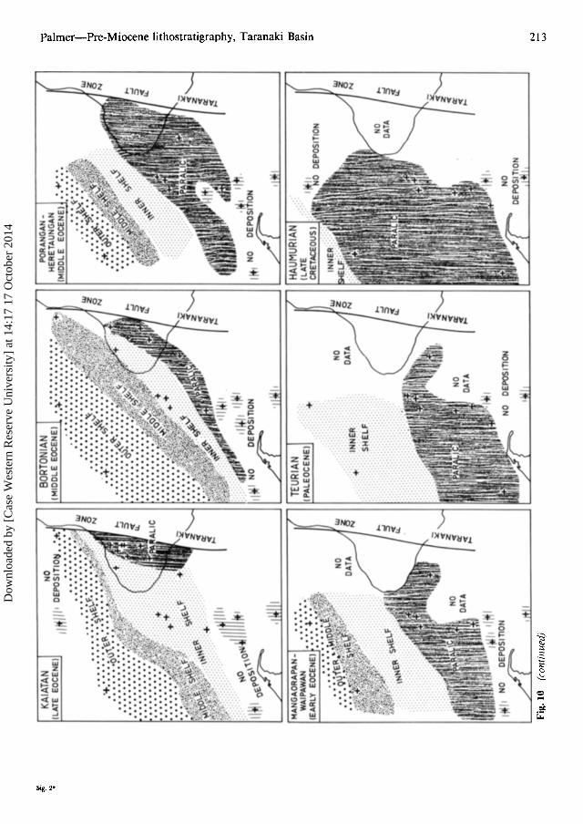
Pale
ogeo
grap
hic
reco
nstr
ucti
onof
Tar
anak
iB
asin
from
Lat
eC
reta
ceou
sto
Ear
lyM
ioce
netim
es,
Dow
nloa
ded
by [
Cas
e W
este
rn R
eser
ve U
nive
rsity
] at
14:
17 1
7 O
ctob
er 2
014
BORT
ONIA
(MID
DLE
EOC
ENE
I~ ~ .
NO
lilt/I"
OE
POSl
TIO
t:l.:.+
.,
....
....
Fig
.10
(con
tin
ued)
+ ,., ..1
INN
ER
SHE
LF
II
PORA
NG
AN
.H
E RET
AU
NG
AN
(MIO
OL
EEO
CEN
E)
;.? 3" o T "'tl
@ S: ~. ::l o _. ... ::r o '"... Pl ~.
'0 9" -l '" Pl ::l '" ~ t:C e; S'
N '-'
Dow
nloa
ded
by [
Cas
e W
este
rn R
eser
ve U
nive
rsity
] at
14:
17 1
7 O
ctob
er 2
014

214 New Zealand Journal of Geology and Geophysics, 1985, Vol. 28
of, but lithologically different and geographicallyisolated from, the Aotea Sandstone of WaitomoCounty to the northeast (Nelson 1978).
The Turi and Otaraoa Formations mark thebeginning of a major marine transgression in central Taranaki Basin. Marine conditions existed inthe north and west of Taranaki Basin during LateCretaceous-Paleocene times and reached centralTaranaki by the Late Eocene-Oligocene.
TIKORANGI FORMATION (new)
Tikorangi Formation is a deep-water, bioclasticlimestone named after the North Taranaki township of Tikorangi. It was first encountered in theMangahewa-l well. Van Rijen & van der Abeele(1963) described a limestone within the Mahoenui"Formation" in Mangahewa-l. A similar sequencehas been encountered in subsequent wells in thearea. The names Tikorangi Member (van Rijen &van der Abeele 1963) and Tikorangi Limestone(Pilaar & Wakefield 1978)have been applied informally to the limestone. Van Rijen & van der Abeele(1963) recognised the correlation between Tikorangi Limestone and Te Kuiti Limestone but considered the Tikorangi Limestone was a member ofthe Mahoenui "Formation". Later, the informalsubdivision of Upper Mahoenui Formation, for thebeds overlying the limestone, and Lower MahoenuiFormation, for those beneath, was adopted (Adamset al. 1980). This paper proposes the name Tikorangi Formation for the limestone, with MahoenuiGroup restricted to the sequence overlying (asdefined by Glennie (1956) and Kear & Schofield(1959», and Otaraoa Formation applied to the siltymudstone immediately underlying, the TikorangiFormation.
The interval from 3213 m to 3250 m BKB inMangahewa-l is designated the type section (Fig.9). Here, Tikorangi Formation consists of 37 m ofblue-grey, sandy limestone, calcareous sandstone,and white crystalline limestone interbedded withcalcareous mudstone (van Rijen & van der Abeele1963). The microfauna in cuttings samples fromMangahewa-l indicate a Waitakian age (McIntyre1962; Cope 1963).
At the type section, Tikorangi Formation is conformable on the calcareous siltstone and mudstoneof the underlying Otaraoa Formation. The upperboundary is conformable with the calcareous mudstone of the overlying Mahoenui Group.
Tikorangi Formation is a bioclastic, deep-waterdeposit that is widespread on the Western Platformand in the north and east of the Taranaki Graben(Fig. 4, 5). A lateral equivalent, the Takaka Limestone, is present in the South Taranaki Basin andnorthwest of the South Island. The Takaka Lime-
stone is an inner-middle shelf deposit (Leask 1980).Further north, the Takaka Limestone grades to adeep-water calcareous mudstone which geographically isolates it from the Tikorangi Formation (Fig.8).
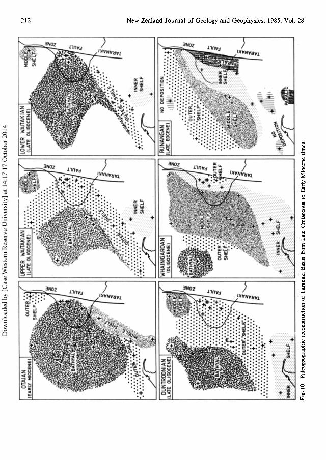
PALEOGEOGRAPHY FROM CRETACEOUSTO EARLY MIOCENE
During the Late Cretaceous and Paleocene, largeareas of Taranaki Basin lay above or very near sealevel (Fig. 10). The sediments deposited were predominantly coal measures and coastal plain deposits. The oldest sediments, the Cretaceous PakawauGroup coal measures, are sporadically distributedacross the basin (Fig. 3). The predominantly terrestrial sediments were deposited in fault-angledepressions formed by normal faulting of basement (Pilaar & Wakefield 1978).These and the LateCretaceous-Early Oligocenecoal measure sequencesare the primary exploration objectives in the Taranaki Basin.
The Kapuni Group is a Paleocene-Oligocenesequence comprised of a lower sandstone-mudstone sequence, the Kaimiro Formation (Dh orolder); overlain by a marine mudstone, the OmataFormation (Dm-Dh). The coal measure sequence,the Mangahewa Formation (Dp-Ak), is overlain byan estuarine to shallow marine sandstone sequence,the McKee Formation (Ar-Lwh). In the easternTaranaki Basin, the sediments are lagoonal-floodplain-coastal deposits, whereas westwards, thesediments exhibit more marine influences. TheOligocene Turi (Lwh) and Otaraoa (Lwh-Lw) Formations and the Late Oligocene-Early MioceneTikorangi (Lw-Po) Formation were deposited in amarine environment.
Paleoenvironmental reconstruction of TaranakiBasin (Fig. 10) shows a major pre-Miocene marinetransgression. This transgression commenced inLate Cretaceous-Paleocene times and progressedthrough to the Miocene. Drilling and regionalseismic data indicate that, during the Late Cretaceous and Paleocene, the Taranaki Basin was anarea oflow relief with a gentle, generally westward,slope. At the beginning of the Eocene, the sea beganto encroach southeastward onto this landmass (Fig.10). Shallow marine sediments were deposited inclose association with terrestrial sediments. The seacontinued to transgress during the Eocene and Oligocene, and by Early Miocene time, the basin laybeneath a sea of bathyal depth (Fig. 1'0).
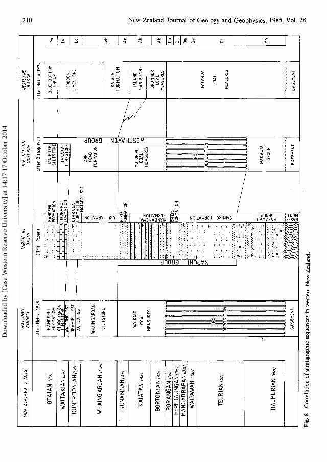
The stratigraphic correlation of the sequencesalong the west coast of New Zealand (Fig. 8) showsclose similarities between the sequence of the Taranaki Basin, the Waitomo County to the northeast(Nelson 1978),and the Westland Basin to the south
Dow
nloa
ded
by [
Cas
e W
este
rn R
eser
ve U
nive
rsity
] at
14:
17 1
7 O
ctob
er 2
014

Palmer-Pre-Miocene lithostratigraphy, Taranaki Basin 215
(Nathan 1974). During Late Cretaceous-Miocenetimes, similar conditions prevailed along the lengthof the western margin of New Zealand.
The Cretaceous-Early Miocene stratigraphicsequence described for Taranaki Basin (Fig. 2, 3)is a regressive-transgressive sequence.
The environments of deposition of the stratigraphic units range from bathyal to outer shelf,through shallow marine, to lagoonal or terrestrial.Interfingering marine and non- to marginal marinesediments indicate a fluctuating but generallytransgressive shoreline that progressed from thenorthwest to the southeast.
Local variations in the sequence were controlledby the paleorelief, relative tectonic movementsbetween the source and depositional areas, proximity to the coast and the source rocks, and thenature of the source rocks. Because of all thesefactors, rapid facies changes occur both locally andregionally, and different formations are laterallyequivalent.
ACKNOWLEDGMENTS
The author thanks Dr T. Haskell and fellow staff ofPetrocorp (Exploration), Mr D. Haw of BP Exploration, andMr G. Pearce of Shell BP and Todd Oil Services Ltd fortheir useful comments. Special thanks also to Mr D. Pimblott and the drafting section of Petrocorp (Exploration)for their assistance in preparing the diagrams.
REFERENCESAdams, E. A.; Palmer, J.; Patchett, J. 1980: Toko-I well
completion report. Petroleum Corporation of NewZealand (Exploration) Ltd report 0120.
Beddoes, L. R. Jun.; Watson, D. W. 1969: Geological wellcompletion report Esso Moa-lB. Esso Explorationand Production New Zealand Inc. New ZealandGeological Survey unpublished open-file petroleum report 402.
Bishop, D. G. 1971: Geological map of New Zealand1:63360. Sheets SI, S3 and pt S4-Farewell-Collingwood. Wellington, Department ofScientific andIndustrial Research.
Cope, R. N. 1963: The time-stratigraphy of Mangahewa-. I, Kapuni-2 and Inglewood-I Taranaki, NewZealand. Shell BP and Todd Oil Services Ltd EPreport 45. New Zealand Geological Survey unpublished open-file petroleum report 442.
Gerlings, H. 0.; Abeele, D. van der 1964: Inglewood-Iexploration well resume. Shell BP and Todd OilServices Ltd EP report 5. New Zealand GeologicalSurvey unpublished open-file petroleum report 444.
Glennie, K. W. 1956: The Oligocene formations of Taranaki. Shell BP and Todd Oil Services Ltd reportGR 5. New Zealand Geological Survey unpublished open-file petroleum report 409.
Haskell, T. R. 1981: Hydrocarbon potential ofthe TarataThrust Zone, Taranaki, New Zealand. Abstract.New Zealand Symposium on Petroleum Geology,Wellington, 25-26 August 1981.
Hay, R. F. 1967: Geological map of New Zealand1:250000. Sheet 7-Taranaki. Wellington,Department of Scientific and Industrial Research.
Hayward, B. W. 1982: Aspects of the micropaleontologyof Rimu-I, McKee-2, 2A, 3 and 3A onshore wells.New Zealand Geological Survey report PAL 49.
Hayward, B. W.; Mildenhall, D. C. 1980: Biostratigraphyof McKee-1 onshore well. New Zealand GeologicalSurvey report PAL 35.
Hayward, B. W.; Pocknall, D. T.; Raine, J. I.; Scott, G.H.; Wilson, G. J. 1982: Biostratigraphy of Kaimiro-I onshore well, Taranaki. New Zealand Geological Survey report PAL 62.
Hedberg, H. D. ed. 1976: International stratigraphic guide.A guide to stratigraphic classification, terminologyand procedure. New York, John Wiley & Sons. 200p.
Hematite and Shell BP and Todd Oil Services Ltd 1975:. Well resume Turi-1. Hematite and Shell BP and
Todd Oil Services Ltd. New Zealand GeologicalSurvey unpublished open-file petroleum report 659.
Hill, P. J.; Collen, J. D. 1978: The Kapuni sandstonesfrom Inglewood-I well, Taranaki-petrology andthe effect ofdiagenesis on reservoir characteristics.New Zealand journal ofgeology and geophysics 21 :215-228.
Hogan, J. A. 1979: Stratigraphy and sedimentology of theKapuni Formation, New Zealand. UnpublishedM.Sc thesis, lodged in the Library, Victoria University of Wellington, New Zealand.
Jonkers, E. W.; Couper, R. A.; Stainton, P. W. 1969: Wellresume Maui-1. Shell BP and Todd Oil ServicesLtd. New Zealand Geological Survey unpublishedopen-file petroleum report 540.
Jonkers, E. W.; Couper, R. A.; O'Fee, E. G. 1970: Wellresume Maui-2. Shell BP and Todd Oil ServicesLtd. New Zealand Geological Survey unpublishedopen-file petroleum report 541.
Kear, D.; Schofield, J. C. 1959: Te Kuiti Group. NewZealand journal ofgeology and geophysics 2 : 685717.
Klugt, S. van der; Sijp, J. W. C. M. van der; Geiger, M.E. 1959: Kapuni-I. Shell BP and Todd Oil ServicesLtd geological report 28. New Zealand GeologicalSurvey unpublished open-file petroleum report 427.
Knox, G. J. 1982: Taranaki Basin, structural style andtectonic setting. New Zealand journal of geologyand geophysics 25: 125-140.
Leask, W. L. 1980: Basin analysis of Tertiary strata inGolden Bay, Nelson. Unpublished M.Sc. thesis,lodged in the Library, Victoria University of Wellington, New Zealand.
McBeath, D. M. 1976: Kapuni and Maui gas-condensatefields of New Zealand-summary. Circum-Pacificenergy and mineral resources. American Association ofPetroleum Geologists memoir 25 : 211-216.
Dow
nloa
ded
by [
Cas
e W
este
rn R
eser
ve U
nive
rsity
] at
14:
17 1
7 O
ctob
er 2
014

216 New Zealand Journal of Geology and Geophysics, 1985, Vol. 28
---- 1977: Gas-condensate fields of the TaranakiBasin, New Zealand. New Zealand journal ofgeology and geophysics 20: 99-129.
McIntyre, D. J. 1962: Pollen from deeply buried coalmeasures, Taranaki, New Zealand-No.2. NewZealand journal ofgeology and geophysics 5 : 314319.
McIntyre, D. J.; Norris, G. 1966: Lower Tertiary pollenand microplankton from deeply buried coal measures, Taranaki, New Zealand. New Zealand journal ofgeology and geophysics 9: 243-246.
Nathan, S. 1974: Stratigraphic nomenclature for the Cretaceous-lower Quaternary rocks of Buller andNorth Westland, West Coast, South Island, NewZealand. New Zealand journal ofgeology and geophysics 17: 423-445.
Neall, V. E. 1979: Geological map of New Zealand1:50000. Sheets P19, P20 and P21-New Plymouth, Egmont and Manaia. Wellington, Department of Scientific and Industrial Research.
Nelson, C. S. 1978: Stratigraphy and paleontology of theOligocene Te Kuiti Group, Waitomo County, SouthAuckland, New Zealand. New Zealand journal ofgeology and geophysics 21 : 553-594.
Palmer, J.; Beardman, J. 1983: McKee-3, -3A, -4, -5 and-5A well completion report. Petroleum Corporation of New Zealand (Exploration) Limited report0184.
Pilaar, W. F. W.; Wakefield, L. L. 1978: Structural andstratigraphic evolution of the Taranaki Basin, offshore North Island, New Zealand. The APEAjournal 18: 93-101.
Rijen, W. M. van; Abeele, D. van der 1963: Explorationwell resume Mangahewa-1. Shell BP and Todd OilServices Ltd. New Zealand Geological Surveyunpublished open-file petroleum report 428.
Shell BP and Todd Oil Services Ltd 1977: Well resumeTane-I (offshore). Shell BP and Todd Oil ServicesLtd. New Zealand Geological Survey unpublishedopen-file petroleum report 698.
Short, K. C. 1962: The stratigraphy of the Taranaki peninsula structure. Shell BP and Todd Oil ServicesLtd EP report 40. New Zealand Geological Surveyunpublished open-file petroleum report 438.
Dow
nloa
ded
by [
Cas
e W
este
rn R
eser
ve U
nive
rsity
] at
14:
17 1
7 O
ctob
er 2
014