lower cretaceous lithostratigraphy across a regional ... · lower cretaceous lithostratigraphy...
TRANSCRIPT
287
Lower Cretaceous lithostratigraphy across a regional subaerial unconformity in Spitsbergen: the Rurikfjellet and Helvetiafjellet formations
Midtkandal, I., Nystuen, J. P., Nagy, J. & Mørk, A.: Lower Cretaceous lithostratigraphy across a regional subaerial unconformity in Spitsbergen: the Rurikfjellet and Helvetiafjellet formations. Norwegian Journal of Geology, Vol. 88, pp. 287-304, Trondheim 2008, ISSN 029-196X
During development of the Lower Cretaceous succession in the Spitsbergen domain of the epicontinental Boreal Basin, a fall in relative sea-level caused a major subaerial unconformity to form. This unconformity forms the lithostratigraphic boundary between the Rurikfjellet Formation below, and the Helvetiafjellet Formation above. The previous Ullaberget Member in the upper part of the Rurikfjellet Formation was originally defi-ned using the Ullaberget section in Nathorst Land as its stratotype. The Ullaberget section is not representative for the upper sandstone-rich mem-ber of the Rurikfjellet Formation, but is chosen here as the stratotype for the new Louiseberget Bed of the Festningen Member. The Louiseberget Bed consists of deltaic sandstone, located above the subaerial unconformity capping the Rurikfjellet Formation, and forms a facies body within the Festningen Member, the fluvially-dominated lower member of the Helvetiafjellet Formation. The Kikutodden Member is here defined as a new member substituting for the Ullaberget Member as the upper, sand-rich part of the Rurikfjellet Formation; the Kikutodden section in Sørkapp Land being the stratotype and the Strykejernet section being new hypostratotype for the member. The Festningen Member and the Glitrefjellet Member in the lower and upper parts of the Helvetiafjellet Formation, respectively, are re-established as formal members.
Ivar Midtkandal, Johan Petter Nystuen and Jenö Nagy, University of Oslo, Department of Geosciences, P.O. Box 1047, Blindern, NO-0316 Oslo, Norway; Atle Mørk, SINTEF Petroleum Research NO-7465 Trondheim, Norway, and Department of Geology and Mineral Resources Engineering, NTNU, Norwegian University of Sciences and Technology, NO-7491, Trondheim, Norway; Ivar Midtkandal, Present address: University of Adelaide, Australian School of Petroleum, Adelaide SA 5005, [email protected]
Ivar Midtkandal, Johan Petter Nystuen, Jenö Nagy & Atle Mørk
IntroductionSvalbard’s Mesozoic succession is characterized by open marine through marginal-marine to continental facies associations of mudstone, shale and sandstone deposited in a shallow epicontinental basin (e.g. Kelly 1988; Mørk et al. 1999). General overviews of the geological development of Svalbard and adjacent parts of the Barents Sea region are given by Steel and Worsley (1984), Nøttvedt et al. (1993) and Worsley (2008).
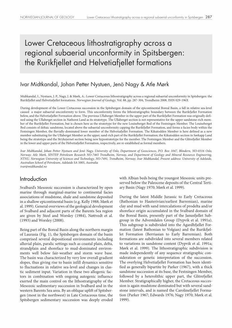
Being part of the Boreal Basin along the northern margin of Laurasia (Fig. 1), the Spitsbergen domain of the basin comprised several depositional environments including alluvial plain, paralic settings such as coastal plain, delta, strandplain and shoreface to mud-dominated environ-ments well below fair-weather and storm wave base. The basin was characterized by very low overall gradient slopes, thus giving rise to basin infill dynamics sensitive to fluctuations in relative sea-level and changes in clas-tic sediment input. Variation in these two allogenic fac-tors in combination with ongoing autogenic influence exerted the main control on the lithostratigraphy of the Mesozoic sedimentary succession in Svalbard and in the western Barents Sea area. By an oblique uplift of Spitsber-gen (most in the northwest) in Late Cretaceous time, the Spitsbergen sedimentary succession was deeply eroded
with Albian beds being the youngest Mesozoic units pre-served below the Paleocene deposits of the Central Terti-ary Basin (Nagy 1970; Mørk et al. 1999).
During the latest Middle Jurassic to Early Cretaceous (Bathonian to Hauterivian/earliest Barremian), marine clay and mud with sand intercalations of prodelta and/or shoreface origin accumulated in the Svalbard domain of the Boreal Basin, presently part of the Janusfjellet Sub-group in the Adventdalen Group (Dypvik et al. 1991a). This subgroup is subdivided into the Agardhfjellet For-mation (latest Bathonian to Volgian) and the Rurikfjel-let Formation (Berriasian to Early Barremian). Both formations are subdivided into several members related to variations in sandstone content (Dypvik et al. 1991a; Mørk et al. 1999). The lithostratigraphic subdivision is made independently of any sequence stratigraphic con-sideration or genetic interpretation of the succession. The overlying Helvetiafjellet Formation has been identi-fied as generally bipartite by Parker (1967), with a thick sandstone succession at its base, the Festningen Member, followed by a heterolithic upper part, the Glitrefjellet Member. Stratigraphically higher, the Cretaceous succes-sion is again mudstone dominated but with several sand-stone intervals, and is named the Carolinefjellet Forma-tion (Parker 1967; Edwards 1976; Nagy 1970; Mørk et al. 1999).
NORWEGIAN JOURNAL OF GEOLOGY Lower Cretaceous lithostratigraphy across a regional subaerial unconformity in Spitsbergen
288
The scope of the present paper is to revise the lithostrati-graphy of the uppermost part of the Rurikfjellet Formation and the overlying Helvetiafjellet Formation (Mørk et al. 1999). The Ullaberget Member has been defined as a sandstone unit in the uppermost part of the Rurikfjellet Formation, located below a regional erosional unconformity separating the open-marine Rurikfjellet Formation from the fluvial and paralic Hevetia fjellet Formation above the unconformity (Różycki 1959; Birkenmajer 1975; Dypvik et al. 1991a, b; Mørk et al. 1999). The Ullaberget cliff section has been assigned as the stratotype for the member, although this particular sandstone unit is not present at this locality. The first sandstone unit one encounters when walking up the Ulla-berget section through the shale-dominated Rurik fjellet Formation is the deltaic sandstone here defined as the Louiseberget Bed overlying the regional unconformity.
The absence of a thick sandstone unit below the regional unconformity at Ullaberget has been the source of repeated misunderstandings regarding the stratigraphy at this locality during subsequent field activities (e. g. excursions). The deltaic sandstones of the Louiseberget Bed have been mistaken for the true Ullaberget Member, as they constitute the lowest sandstone interval at Ulla-berget. Recent investigations on the northern side of Van Keulenfjorden in Nathorst Land (Ahokas 2004; Midt-kandal et al. 2005; Midtkandal et al. 2006; Midtkandal 2007; Midtkandal & Nystuen 2009) have shown that the regional erosional unconformity here can be traced at the base of the lowest sandstone and along the entire cliff face that spans Annaberget, Louiseberget and Ullaberget. These observations are in accordance with the geological map covering the area produced by the Norwegian Polar Research Institute (Dallmann et al.1990).
As the Ullaberget section on the north side of Van Keulen-fjorden was chosen as stratotype for the Ullaberget Mem-ber of the Rurikfjellet Formation (cf. Mørk et al. 1999),
these new observations create the need for a revision of type sections and redefinition of members both above and below the unconformity.
In other parts of Spitsbergen, sandstone units supposed to be lateral correlatives to the Ullaberget Member in the stratotype section are all located below the regional ero-sional unconformity, at least within the Svalbard domain of the Boreal Basin. For this reason, we propose the name Kikutodden Member of the Rurikfjellet Formation for this sand-dominated unit below the unconformity, while for the unit above the unconformity, we propose the name Louiseberget Bed of the Festningen Member (lower part of the Helvetiafjellet Formation in Nathorst Land, Appendi-ces 1 and 2). We also propose to re-establish the formal status of the “Festningen sandstone member” (Mørk et al. 1999), as the Festningen Member in the lower part of the Helvetiafjellet Formation, and retain the Glitrefjellet Member (Parker 1967) as a formal unit in the upper part of the Helvetiafjellet Formation. The Glitrefjellet Member was abandoned as a lithostratigraphic unit by Mørk et al. (1999). The changes in lithostratigraphic nomenclature proposed in this paper were reviewed and accepted by the Norwegian Stratigraphic Committee (NSK) prior to submission of the article to the Norwegian Journal of Geology for publication.
Use of the name Ullaberget Member and related terms through timeThe starting point for events leading to use of the term Ullaberget in stratigraphic nomenclature dates back to observations made by J. G. Anderson in 1898, dealing with the shale-mudstone succession exposed below the sandstone cliffs at Ullaberget, located on the northern side of Van Keulenfjorden. Referring to Anderson, these observations came to be published by Nathorst (1910), including Anderson’s sketchy drawing of the eastern part
I. Midtkandal et al. NORWEGIAN JOURNAL OF GEOLOGY
Palaeo-landBoreal Basin (ocean)
Spitsbergendomain
Sverdrup Basin
Barents shelfdomain
60˚N
1000 km
127 Ma
N
Greenland
L A U R A S I A
Fennoscandia
Novaya Zemlya
Fig. 1 Boreal Basin palaeogeography at 127 Ma, showing Spitsbergen’s position relative to major land-masses. Map data is modified from Torsvik et al. (2001, 2002).

289
of Ullaberget (Fig. 2) and a short note stating that the upper part of the succession below the sandstone cliffs, currently referred to the Janusfjellet Subgroup, consists of shattered dark shale (“dunkle, zerfallende Schiefer” Nathorst 1910) with globular calcareous concretions. The presence of sandstones at this level is not mentioned in the report. However, an extensive sandstone body with thin coal seams and an abrupt lithological bound-ary towards the underlying thick shale were noted. This is important because the occurrence of sandstone beds at several stratigraphical levels and as upward-coarsening parasequences is a significant feature of the Ullaberget unit of later authors (e.g. Różycki 1959; Birkenmajer 1975; Edwards 1976; Mørk et al. 1999; Dypvik et al. 1991a).
The first formal use of “Ullaberget” in stratigraphic nam-ing was by Różycki (1959) in his pioneering study of the geology of the region south of Van Keulenfjorden (east-ern Wedel Jarlsberg Land and western Torell Land). In this region, he observed at several localities a sandy, regressive development in the uppermost part of the Janusfjellet Subgroup, and designated it the Ullaberget Series. In this connection he referred to the observations reported by Nathorst (1910), but his short description of the Ullaberget series is based on the Skiferkammen (pre-viously named Jurakammen) section located in Torell Land.
According to Różycki (1959), the upper part of the Rurik-fjellet Formation (his Ullaberget Series) on Skiferkam-men contains only three thin sandstone interbeds “with fine-grained quartz gravel” The thickness of these beds is, however, only 10, 120 and 20 cms, respectively. This very low sand content makes the Skiferkammen section clearly inapplicable as a stratotype or hypostratotype for the relatively thick, sand-dominated Kikutodden Mem-ber. The low sand content of this stratigraphic interval at Skiferkammen is also apparent from the section repro-duced here (cf. Fig. 10). A similar sand-poor develop-ment of the upper Rurikfjellet Formation is also shown on the nearby Polakkfjellet (~18,5 km south of Skifer-
kammen, see Fig. 3) by Birkenmajer (1975), and in the Agardhbukta area close to the east coast where Dypvik et al. (1991b) reported only silty shales.
The Ullaberget unit was subsequently redescribed by Birkenmajer (1975), in a paper dealing with the Jurassic and Cretaceous formations in southwestern Torell Land (Fig. 3). His concept of this unit follows essentially that of Różycki (1959), but he gave it a formal member status and an emended definition. According to his description, the member is a succession of brownish to black, often bioturbated shales, interbedded with siltstones and sand-stones. Its basal contact is gradational, while its upper contact, against the Festningen Member (of the Helve-tiafjellet Formation), is sharp and seems to represent a break in deposition.
The stratigraphic name Ullaberget Member (sensu Różycki, 1959, emended Birkenmajer 1975) as a designa-tion for the uppermost subunit of the Rurikfjellet Forma-tion, was applied both in the western and eastern outcrop belts of the Rurikfjellet Formation in subsequent papers, e.g. Nemec et al (1988), eastern Spitsbergen; Dypvik et al. (1991a), central Spitsbergen; Dallmann et al. (1993), Sørkapp Land.
In Mørk et al. (1999), the current authoritative work which revises the lithostratigraphy of the Mesozoic suc-cession in Svalbard, the Ullaberget Member is referred to as the uppermost, generally upward coarsening part of the Rurikfjellet Formation. It is recognized in all sec-tions where this formation is exposed on Spitsbergen. The Ullaberget section in Nathorst Land (Fig. 3) was chosen as its stratotype. The unit was in this work cor-related with the Kikutodden sediment package, defined by Pčelina (1983). The Kikutodden section in Sørkapp Land, recorded by Edwards (1976), was designated as the hypostratotype for the unit.
Pčelina (1983) described the Kikutodden package as sand rich, with thin mud- and siltstone layers. Carbonized
Fig. 2 The Ullaberget outcrop, published in Nat-horst (1910). The sketch, made by Anderson in 1898, shows folded strata (lower left) in the muds-tone-dominated Rurik-fjellet succession and a lithologically sharp upper boundary to the Helve-tiafjellet Formation. The figure shows the basis for lithostratigraphic subdi-vision across the regional unconformity that marks the base of the sandstone beds. (No scale is included in the original).
NORWEGIAN JOURNAL OF GEOLOGY Lower Cretaceous lithostratigraphy across a regional subaerial unconformity in Spitsbergen

290
plant remains and coal seams were also recorded within this unit. This description does not indicate an open marine shelf environment, which is the setting suggested by Mørk et al. (1999) for the Ullaberget Member. Fur-thermore, the Kikutodden package is listed as a subunit of the Helvetiafjellet Formation in Pčelina (1983). This assignment may have been a mistake in the 1983 publi-cation, as Pčelina as co-author of the Mørk et al. (1999) publication regarded the unit as part of the Rurikfjellet Formation and the Ullaberget Member.
Based on this review the following can be concluded: (1) The first use of the name “Ullaberget” as a lithostrati-graphic unit (Różycki, 1959, the Skiferkammen section) did not involve a sandstone-dominated interval above the regional unconformity and immediately below the Fest-ningen Member of the Helvetiafjellet Formation, or in a position lateral to the typical fluvial Festningen Member (see below), (2) Based on published data and on the pres-ent studies we can not definitely exclude the possibility that the Ullaberget Member, as currently defined, is present also in the Ullaberget section, but if so it must lie beneath
the regional unconformity at the base of the Helvetiafjellet Formation, (3) The possible presence of a unit in the Ulla-berget section, corresponding to the original definition of the Ullaberget Member as a sand-dominated member in the upper part of the Rurikfjellet Formation (see below), has to be taken into consideration when naming the new sandstone member above the unconformity.
The Ullaberget – Louiseberget – Anna-berget outcrop areaUllaberget is the easternmost of three marked mountain peaks in Nathorst Land on the northern side of the outer part of Van Keulenfjorden. Louiseberget is located fur-ther to the west and Annaberget is the westernmost of these three mountains (Fig. 3). The southern sides of the mountains form a large outcrop area exposing the upper part of the Rurikfjellet Formation, the Helvetiafjellet Formation and the lower part of the Carolinefjellet For-mation. Figure 4 shows the Ullaberget locality with the revised lithostratigraphic subdivision.
Kvalvågen
Agardhbukta
Glitrefjellet
Torellbreen
Konusen
NordenskiöldLand
Myklegardfjellet
Osbornfjellet
Keilhaufjellet, Kikutodden
Polakkfjellet
WedelJarlsberg
Land
Fig. 3 Locality map showing parts of Svalbard, with Nathorst Land inserted. Locali-ties in text are marked with black circles. Long-yearbyen, the largest settlement in Svalbard, is marked with a star.
I. Midtkandal et al. NORWEGIAN JOURNAL OF GEOLOGY

291
A discontinuously exposed unconformity at the base of the cliff-forming, sandstone-dominated Helvetiafjellet Formation forms the upper boundary of the Rurikfjellet Formation that crops out in the lower part of the moun-tain slopes. The degree of sandstone content within the uppermost part of the Rurikfjellet Formation is not easy to estimate, as scree covers most of it and also parts of the overlying Helvetiafjellet Formation in this area. The Rurikfjellet Formation is, in most exposures, dominated by dark grey to black mudstone and shale with scattered siderite concretions, but thin beds of light grey siltstone and very fine-grained sandstone are present at several stratigraphic levels. The Rurikfjellet Formation may also here be organized in distal, upward-coarsening units, but this possible stratigraphic feature has not been con-firmed.
The Rurikfjellet and Helvetiafjellet formations are, in this area, affected by tectonic movements associated with the development of the Tertiary fold and thrust belt along the western coast of Spitsbergen (e.g. Braathen et al. 1999). The strata are generally tilted towards the east. The thick (>200 m) mudstone succession of the Rurikfjellet For-mation is folded disharmonically by shorter wavelength folds relative to the overlying Helvetiafjellet Formation. A low-angle thrust fault has cut up-section through the Rurikfjellet Formation and into the overlying Helve-tiafjellet Formation in the area between the Ullaberget and Louiseberget mountains and displaced the hanging wall towards the east (Fig. 3). The horizontal shortening along the thrust fault is estimated to be less than 1 kilo-metre.
The erosional unconformity on top of the Rurikfjellet Formation is exposed in the lower slopes of the Ulla-berget, Louiseberget and Annaberget mountains. This unconformity separates the dark grey mudstone of the underlying shale-dominated Rurikfjellet Formation from a cliff-forming sandstone unit above. The lithological boundary is very distinct and is marked by a thin, dis-continuous conglomerate bed, with well-rounded extra-basinal quartzite clasts ranging from 3 to 12 cm in diam-eter. The conglomerate varies in lithology from single isolated clasts to a matrix- and clast-supported aggregate of clasts up to 25 cm in thickness. In the Annaberget sec-tion, irregularly shaped rip-up mudstone clasts from the Rurikfjellet Formation are intermingled with the quartz-ite clasts.
The regional subaerial unconformityThe basal erosional boundary of the Helvetiafjellet For-mation described above in the Ullaberget – Louiseber-get – Annaberget section is recorded as having a similar appearance throughout the outcrop area on Svalbard (Steel 1977; Nemec et al. 1988; Nøttvedt et al. 1993; Ahokas et al. 2005; Midtkandal et al. 2006; Hurum et al. 2006; Midtkandal 2007). The unconformity formed dur-ing the emergence and subsequent drowning of the low gradient, shallow epicontinental Boreal Basin (Fig. 1). An unknown amount of the Rurikfjellet Formation was eroded in the process.
The exposures of the unconformity mark the boundary between underlying mud-dominated, open marine shelf
HelvetiafjelletFormation
Carolinefjellet Formation
Louiseberget Bed
Glitrefjellet Member
Rurikfjellet FormationRegional unconformity
Festningen Member
20 m
Fig. 4 The Ullaberget outcrop with the revised lithostratigraphic sub-division of the Helvetia-fjellet Formation. Below the regional erosional unconformity, the upper part of the Rurikfjellet Formation is cropping out, and shows dark shale and thin siltstone beds. The Kikutodden Member is not present. The boundary between the deltaic Louiseberget Bed and the overlying facies of the undiffe-rentiated Festningen Member is stippled. The lowest sandstone-rich part of the Glitrefjel-let Member consists of tidal bars and tidal channel deposits.
NORWEGIAN JOURNAL OF GEOLOGY Lower Cretaceous lithostratigraphy across a regional subaerial unconformity in Spitsbergen

292
and/or sandy shoreface successions in the Rurikfjellet Formation and coarse-grained sandstone and conglom-erate above (Figs. 5 and 6).
The sheet-like fluvial sandstone unit is thought to represent mainly deposits laid down by braided streams at the onset of deposition of the Helvetiafjellet Formation, and referred to as the Festningen Member (Edwards 1979; Nemec 1992; Midtkandal et al. 2005). The erosional unconformity is generally overlain by a thin fluvial conglomerate bed, as in the Nathorst Land outcrops described above and also in Kvalvågen (Fig. 6). The diameter of the clasts is up to 15 cm, with a mean of about 5-6 cm. The clasts are well rounded, subspherical and poorly sorted, consisting of hydrothermal quartz, quartzite and chert. The widespread and smooth character of the erosional boundary and the sheet-like geometry of the fluvial sandstone (Figs. 5 and 7) may be attributed to frequent events of channel avulsions on the alluvial to coastal plain, like the process described by Holbrook (1996), due to limited vertical accommoda-tion space during the initial rise in relative sea-level after the sea-level fall.
Fig. 5 The lower boundary of the Helvetiafjellet Formation at Myklegardfjellet, near Agardhbukta, east Spitsbergen (see Fig. 3 for location). This type of contact between the Rurikfjellet Formation and the Helvetiafjellet Formation is typical for several localities across Spitsbergen, where the coarse grained sandstone beds of the Festningen Member rest directly on dark mudstones belonging to the Rurikfjellet Formation. Note the absence of any significant sandstone content in the exposed Rurikfjellet Formation.
Fig. 6 Erosional unconformity within one of the displaced blocks of the Festningen Member at Kvalvågen, SE Spitsbergen. The uncon-formity marks the boundary between underlying hummocky cross stratified sandstone beds of the Rurikfjellet Formation and the coarse grained fluvial conglomerate of the Festningen Member, Hel-vetiafjellet Formation.
I. Midtkandal et al. NORWEGIAN JOURNAL OF GEOLOGY
293
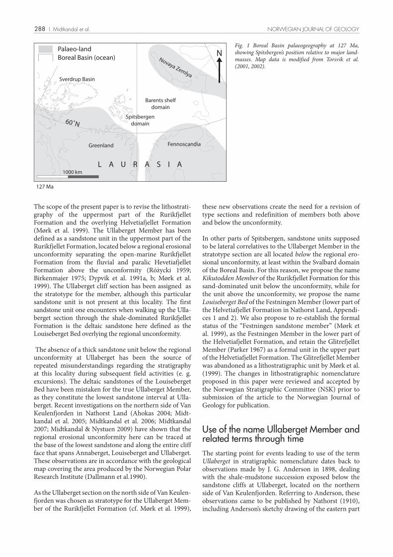
Fig. 7 Selected outcrop sections from across Spitsbergen, showing the stratigraphic development of the upper Rurikfjellet and the Helvetiafjellet formations. For locations, refer to Fig. 3. Red line marks the base of the Festningen Member. a): outcrop near Osbornfjellet, (Fig. 3 for location) east Spitsbergen, showing the full development of the stratigraphy in the area; the dark shale beds of the Rurikfjellet Formation are eroded at the contact with the Festningen Member (red line), followed by the heterolithic Glitrefjellet Member (above the solid white line), overlain by the Carolinefjellet Formation (stippled white line); The Festningen Member is ca 20 m thick here. b): Kikutodden Member at Keilhaufjellet, Sørkapp Land, Spitsbergen (Fig. 3 for location). The lowest, dark cliffs are sand-rich beds of the Rurikfjellet Formation, followed by the Hel-vetiafjellet Formation above the red line. Photo: W.K. Dallmann. c): Louiseberget cliff section, with the Helvetiafjellet Formation above the erosional unconformity (red line). d): The upper Rurikfjellet Formation and the Helvetiafjellet Formation at Glitrefjellet, central Spitsbergen. e): Konusen, central Spitsbergen. f): Festningen, at the Mouth of Isfjorden, west Spitsbergen; this is the type locality for the Festningen Member; the strata are tilted to ~90°, with stratigraphic up to the left in the photo (east); photo by Asle Strøm.
NORWEGIAN JOURNAL OF GEOLOGY Lower Cretaceous lithostratigraphy across a regional subaerial unconformity in Spitsbergen

294
The Kikutodden Member of the Rurikfjellet Formation: a shoreface parasequence setAs previously mentioned, the Ullaberget Member of the Rurikfjellet Formation was defined by Birkenma-jer (1975) based on previous work by Różycki (1959). The Ullaberget section was chosen as its stratotype, the unit name being derived from the Ullaberget loca-tion. The logged section of Edwards (1976) at Kikutod-den in Sørkapp Land was defined as its hypostratotype (cf. Mørk et al. 1999) (Fig. 8). As documented above, the section in Ullaberget does not possess the composition needed to be the stratotype for the sand-rich member in upper part of the Rurikfjellet Formation. Furthermore, as also stated above, in lack of any recognizable major sand-rich unit in the upper part of the Rurikfjellet Formation in the Ullaberget section, the term “Ullaberget member” has, by visitors to the Ullaberget locality, commonly been applied to the unit described and defined in this paper as the Louiseberget Bed in the lower part of the Helve-tiafjellet Formation (see below). This is irrespective of the fact that it is included in the Festningen Sandstone Member on the Norwegian Polar Research Institute map sheet Van Keulenfjorden (Dallmann et al. 1990). Due to all these confusions, the name “Ullaberget” has to be dis-carded as a Member name in the upper part of the Rurik-fjellet Formation, according to the rules for stratigraphic definition and naming (Nystuen 1989, p. 14).
The Kikutodden succession, reproduced as stratigraphic section M-79 in Mørk et al. (1999, p. 194), is here pro-posed as the new stratotype for the upper, sand-rich member of the Rurikfjellet Formation. Though Pčelina (1983) termed her “Kikutodden package” as part of the Helvetiafjellet Formation, it has become clear that this unit was meant to be identical with the sandstone-rich succession in the upper part of the Rurikfjellet Forma-tion, later referred to as the “Ullaberget Member” (Mørk et al. 1999), see above. The name Kikutodden Member is, from the arguments presented above, here chosen as a substitute for the old “Ullaberget Member”. The new hypostratotype is the section at Strykejernet (Figs. 3 and 9) in Torell Land.
n = 12
n = 30
n = 23
n = 47
n = 9
n = 26
n = 29
0
50
100
150
200
m
siltst.m
ud
st.
sst. cgl.
Ruri
kfje
llet
Form
atio
n
Kik
uto
dd
en M
emb
er
Hel
veti
afje
llet
Fo
rmat
ion
Fest
nin
gen
Mem
ber
Glit
refje
llet
Mem
ber
Kikutodden, Sørkapp Land
Congl
Sandst.
Mudst./Siltst.
coal
LITHOLOGY SEDIMENTARY STRUCTURES
Cross beddingRipple laminationFlaser beddingWavy bedding
Lenticular bedding
Palaeocurrent
Intense bioturbation
vertical burrows
Diplocraterion bed
Plant fragments
Plant roots
Dinosaur footprint
Coal
Sideritic nodules
.
C
Fig 8 Sedimentological log from Kikutodden, Sørkapp Land (see Fig. 3 for location), modified from Edwards (1976). This succession is proposed as the stratotype for the Kikutodden Member of the Rurik-fjellet Formation. The legend is also applicable to logs from Stryke-jernet, Skiferkammen, Ullaberget and Glitrefjellet (Figs. 9, 10, 12 and 15), respectively.
n = 12
n = 30
n = 23
n = 47
n = 9
n = 26
n = 29
0
50
100
150
200
m
siltst.m
ud
st.
sst. cgl.
Ruri
kfje
llet
Form
atio
n
Kik
uto
dd
en M
emb
er
Hel
veti
afje
llet
Fo
rmat
ion
Fest
nin
gen
Mem
ber
Glit
refje
llet
Mem
ber
Kikutodden, Sørkapp Land
Congl
Sandst.
Mudst./Siltst.
coal
LITHOLOGY SEDIMENTARY STRUCTURES
Cross beddingRipple laminationFlaser beddingWavy bedding
Lenticular bedding
Palaeocurrent
Intense bioturbation
vertical burrows
Diplocraterion bed
Plant fragments
Plant roots
Dinosaur footprint
Coal
Sideritic nodules
.
C
I. Midtkandal et al. NORWEGIAN JOURNAL OF GEOLOGY

295
m si vf f m c vc gr cgl
sand
Fest
nin
gen
Mem
ber
Tiro
larp
asse
tM
emb
er (?
)Po
lakk
fjelle
t B
ed
Ruri
kfje
llet
Form
atio
nH
elve
tiaf
jelle
t Fo
rmat
ion
C
Glit
refje
llet
Mem
ber
Skiferkammen, Torell Land
10
0
20
30
40
10
20
30
40
50
60
70
80
90
100
60
50
70
80
Fig. 10 Sedimentological log from Skiferkammen, eastern Torell Land. The Rurikfjellet Formation is heavily dominated by shales and mudstones while siltstones are strongly subordinate and sandstones are quantitatively insig-nificant. Thus, the Kikutodden Member is absent. See Fig. 8 for legend.
C
Strykejernet, Torell LandH
elve
tiaf
jelle
t Fo
rmat
ion
Fest
nin
gen
Mem
ber
Kik
uto
dd
en M
emb
erG
litre
fjelle
t M
emb
er
Ruri
kfje
llet
Form
atio
n
200
150
100
50
0mM Si vf f m c vc
Sandstone
Fig. 9 Sedimentological log from Strykejernet, Torell Land, modified from Mørk (1978). This succession is proposed as hypostratotype for the Kikutodden Member of the Rurikfjellet Formation. See Fig. 8 for legend.
NORWEGIAN JOURNAL OF GEOLOGY Lower Cretaceous lithostratigraphy across a regional subaerial unconformity in Spitsbergen

296
The Kikutodden Member (Appendix 1) consists of dark grey to black shale, mudstone, siltstone and sandstone lithologies in laminae and beds organized commonly in at least three upward-coarsening successions. In central Spits-bergen (from Bohemanflya to Lardyfjellet, the number of such upward-coarsening successions varies from one to five (Dypvik et al. 1991a, b). Siderite concretions are com-mon in the dark grey and black shale facies. These upward-coarsening units are all bounded at their base and top by conformable flooding surfaces in laminated and massive mudstones; the units are thus parasequences in sequence stratigraphic terminology (Van Wagoner et al. 1988).
The parasequences are thought to represent prodelta to shallow marine shelf deposits (Mørk et al. 1999). They may be associated with one large delta complex, or most likely, with several deltaic depocentres, thus representing distal equivalents of various delta lobes and/or shore-face deposits. These upward coarsening successions were formed by upward-shallowing on a gently slop-ing ramp. On this ramp the water depth changed from below storm wave base with laminated and bioturbated dark grey to black shales, to above fair-weather wave base with cross-stratified shoreface sandstone beds forming the upper part of individual parasequences. The gen-eral stratigraphic trend within the Kikutodden Member is an aggradational or upward-shallowing development displayed by a set of stacked regressive parasequences
(Figs. 8 and 9). In the stratotype, as well as in the hypost-ratotype, the Kikutodden Member is limited upwards by a thick unit of marine shale of the Rurikfjellet For-mation that is in turn truncated by the regional uncon-formity beneath the Helvetiafjellet Formation, with the fluvial Festningen Member resting directly on the ero-sional surface. At several other localities (Figs. 5, 7, 11), the Kikutodden Member is not present in the upper-most part of the Rurikfjellet Formation, or is overlain by a thick shale and mudstone unit lacking sand-rich, upward-coarsening bedsets and parasequences.
The Louiseberget Bed: a bay-head delta sandstone successionThe Helvetiafjellet Formation is well exposed along the cliffs in the Ullaberget-Louiseberget-Annaberget outcrop area on the northern side of Van Keulenfjorden. The formation is recognizable as a prominent cliff-forming sandstone succession that overlies the mudstone-shale dominated upper part of the Rurikfjellet Formation in this area. The Helvetiafjellet Formation at Ullaberget displays, as everywhere else in Spitsbergen, a lower part dominated by thick sandstone bodies, the Festningen Member, and an upper heterolithic part of alternating marginal marine to coastal plain sandstone and mud-stone intercalations (Fig. 12), the Glitrefjellet Member.
Rurikfje
llet F
ormatio
nFestningen M
emberGlitr
efjelle
t Member
Helvetiafjellet Formation
Carolinefje
llet F
ormatio
n
Fig. 11 The outcrop at Skiferkammen (referred to as Fotografryggen in Mørk et al. (1999), p. 198, Fig. 3-79), eastern Torell Land. The lithos-tratigraphic subdivision is well illustrated here, as shown by the annotations. The Festningen Member is estimated to be ca. 25 m thick here.
I. Midtkandal et al. NORWEGIAN JOURNAL OF GEOLOGY

297
In most areas of Spitsbergen the Festningen Member is “interpreted as mainly fluvial, although intercalated with fluvial-dominated mouth bar and interdistributary bay environments” (Mørk et al. 1999, p. 200). In the mid-dle and eastern part of the Louiseberget section and in the Ullaberget section, the lower part of the Festningen Member forms a sandstone succession resting on the ero-sional unconformity that cuts the top of the Rurikfjellet Formation. The unit is here defined as the Louiseberget Bed of the Festningen Member in the Helvetiafjellet For-mation (Appendix 2). The overlying coal-rich mudstone followed by thin-bedded sandstone beds with thin coal seams are included in the Festningen Member, but not in the Louiseberget Bed (Figs. 12, 13). Gjelberg & Steel (1995, Fig. 3, p. 574) also noted this interval above the basal unconformity of the Helvetiafjellet Formation in the Ullaberget section.
An equivalent deposit to the Louiseberget Bed in the type area occurs at Svedenborgstupet, Northern Nathorst Land (Fig. 3). This unit probably represents the same depositional environment, but is separated from the lower Louiseberget and Ullaberget strata by an interfluve area in central Nathorst Land between two sub-parallel incised valleys (Midtkandal 2007).
The thickness of the Louiseberget Bed varies from 2 to c. 25 m, but is typically 12-15 m. The maximum thick-ness is recorded in the central Ullaberget section, where it is estimated to exceed 20 m. The Louiseberget Bed has been traced in the middle and eastern Louiseberget sec-tion and along the entire Ullaberget section over a dis-tance of roughly 3 km, semi-parallel to palaeocurrent directions trending towards SSE. The eastern termina-tion of the Louiseberget Bed is not exposed, but its thick-ness reduction towards the east may suggest a down-dip pinchout within 1-1.5 km from its easternmost exposure. The thrust fault with a suggested horizontal shortening of less than 1 km between the Ullaberget and Louise-berget mountains (see above) adds to the total deposi-tional dip extent of the Louiseberget Bed; here proposed to have been between 5 and 6 km. The extent along the depositional strike of the Louiseberget Bed is poorly con-strained; its width has been measured to be about 2 km from the Louiseberget locality to its lateral palaeotopo-graphic bounding escarpment. The western termination of the Louiseberget Bed is rather abrupt, with a signifi-cant thickness decrease and ultimate termination over a few tens of metres in the central Louiseberget section. Further west, along the western part of Louiseberget and into Annaberget, the basal sandstones are recorded
Ullaberget, Nathorst Land
0m
90
80
70
60
50
40
30
20
10
110
100
m si sand p
C
Hel
veti
afje
llet
Form
atio
nRu
rikf
jelle
t Fo
rmat
ion
Car
olin
efje
llet
Form
atio
n
Lou
iseb
erg
etB
edFest
nin
gen
Mem
ber
Glit
refje
llet
Mem
ber
Fig. 12 Sedimentological log from Ullaberget, Nathorst Land. The lowest sandstone unit in the Helvetiafjellet Formation is interpre-ted to represent a bay-head delta formed in an incised valley during the earliest stages of relative sea-level rise (Midtkandal & Nystuen). This succession forms the stratotype for the Louiseberget Member, Helvetiafjellet Formation. See Fig. 8 for legend.
NORWEGIAN JOURNAL OF GEOLOGY Lower Cretaceous lithostratigraphy across a regional subaerial unconformity in Spitsbergen

298
as braided fluvial stream deposits with thin heterolithic floodplain deposits near their top, and correspond litho-logically to the main fluvial lithofacies of the Festningen Member elsewhere on Spitsbergen (Fig. 13).
The Louiseberget Bed is characterized by a lower sand-stone with tabular and trough cross-stratified beds. Mean palaeocurrent direction is roughly 135˚, with ±45˚ variation. Grain size of the sand is fine to medium with scattered 1-1.5 cm conglomerate pebbles and mud-stone clasts in the lower 1-2 m. A 10 cm thick bed with horizontal mudstone lamination and 2-3 cm deep roots marks the top of the first 1-2 m. Single and double mud drapes are observed within cross-stratified sandstone beds above the lower 1-2 m interval. These sandstone beds are organized in sets of clinoforms, 3-6 m thick (Fig. 14), separated by discontinuous mudstone horizons. The mudstone beds and laminae thicken downdip along the clinoforms, forming together a thin discontinuous mud-stone bed on top of the regional unconformity and the conglomerate at the base of the unit. Skolithos burrows are associated with the mudstone horizons between the sets of cross-stratification. Clinoform lengths increase from 3-5 m at the western lateral limit to more than 30 m where the Louiseberget Bed is thickest in the Ullaber-
get section. The orientation of the cliff section is slightly oblique to the mean palaeocurrent direction, and the true clinoform dimensions are thus inferred to be somewhat larger than those measured.
The upper part of the Louiseberget Bed is characterized by upward thinning of sandstone beds and ends abruptly where a 3-7 m thick mudstone unit with thin coal and sandstone beds overlies the sandstone interval. A fluvial sandstone body forming the upper part of the Festningen Member then overlies this mudstone unit. A subaerial unconformity is inferred to be present beneath the mud-stone with coal beds (Midtkandal & Nystuen 2009). The Louiseberget Bed sandstones are readily recognizable as pale yellow in contrast to the white beds of the undiffer-entiated Festningen Member sandstones. Higher up in the Helvetiafjellet Formation, in the Glitrefjellet Member, the sandstone beds are dirty gray and yellow. The lowest 1-2 m of the Louiseberget Bed is interpreted to repre-sent a fluvial deposit that was formed during the earli-est stages of deposition of the Helvetiafjellet Formation. The remainder of the Louiseberget Bed is interpreted as having been deposited in a shallow, tidally influ-enced bayhead delta comprising sand-rich delta front beds (Midtkandal 2007). Coarse-grained sediment was
5,4 km1 1‘
W E
Annaberget Louiseberget covered, faultedcovered Ullaberget
100
m
Rurikfjellet Formationregional unconformity
position of logtrace in Fig. 12
Louiseberget Bed
Glitrefjellet Member
Festningen Member (continues)
Carolinefjellet Formation
Hel
veti
afje
llet
Form
atio
nFig. 13 Outline profile showing the Annaberget, Louiseberget and Ullaberget outcrop sections in southern Nathorst Land. See Fig. 3 for location.
Fig. 14 Sandstone succession in the Louiseber-get Member at Ullaberget. Note the clinoform geometries that reflect delta progradation from left to right in the picture.
I. Midtkandal et al. NORWEGIAN JOURNAL OF GEOLOGY

299
transported by rivers directly into the sea, thus deposit-ing sand and pebbly sand in rather steeply dipping large foreset units, as progradational clinoforms. The bay-head delta developed as the relative sea-level rose and filled the area where the initial fluvial sediment veneer had been deposited. The presence of single and double mud drapes suggests that tidal currents regularly reworked the deltaic foreset beds. The shoreline embayment was the result of the marine intrusion into a wide incised valley that terminated to the west against a knick-point escarp-ment (Midtkandal 2007). The dark mudstone with thin coal beds that formed above the interval here named the Louiseberget Bed is interpreted as a coastal plain succes-sion that in turn was capped by braidplain sand belong-ing to the upper part of the Festningen Member.
A subaerial unconformity separates the deltaic Louiseber-get Bed from the alluvial-coastal plain with coal beds and fluvial channel sandstone belonging to the upper part of the Festningen Member. The lateral extent of this uncon-formity is unknown, as is also the duration of the diastem or hiatus between the delta and the overlying continental deposits. Age constraints on the Helvetiafjellet Formation are based on dating of the strata below and above the for-mation, as no age diagnostic fossils are recorded from the continental to paralic succession in between (Grøsfjeld 1992; Gjelberg & Steel 1995; Mørk & Smelror 2001). The former Ullaberget Member was inferred as having been deposited in the Valanginian-Early Barremian, contem-poraneously with the Rurikfjellet Formation. The Lou-iseberget Bed is likely of Barremian age, as has also been suggested for the Festningen Member (Mørk et al. 1999).
The Festningen MemberThe Festningen Member, originally defined by Parker (1967) as a mappable lithostratigraphic unit at the base of the Helvetiafjellet Formation, was given informal unit sta-tus, as the “Festningen (sandstone) member” by Mørk et al. (1999). The reason for the degradation to informal status was “that a clear definition and delimitation against other parts of the Helvetiafjellet Formation is impossible” (Mørk et al. 1999, p. 199), and furthermore, “As shown by Steel (1977) and Gjelberg & Steel (1995), the Festningen sand-stone member consists of several interfingering sandstone lobes” (Mørk et al. 1999, p. 200). Observations from a variety of outcrop areas are in agreement with the original statement by Parker (1967) that the lower sandstone mem-ber in the Helvetiafjellet Formation has a sheet-like geom-etry within the Spitsbergen domain of the Boreal Basin.
The Festningen Member is generally interpreted as being dominated by fluvial, primarily braided stream facies sandstone beds. The fluvial facies may interfinger locally with floodplain, crevasse splay, fluvial mouth bar and bay-head delta deposits (Steel 1977; Gjelberg & Steel 1995), as also demonstrated by the Nathorst Land outcrops described above. The “interfingering sandstone lobes” in
the upper part of the Helvetiafjellet Formation are distrib-utary fluvial channel sandstone bodies within the paralic succession of the heterolithic Glitrefjellet Member (Midt-kandal et al. 2007). These relatively thin fluvial sandstone bodies may be genetically related to the braidplain depos-its of the Festningen Member in updip section, north-west of the present Spitsbergen outcrops. However, in the Spitsbergen domain of the Boreal Basin, these fluvial sandstone units are lithostratigraphically integrated archi-tectural elements of the Glitrefjellet Member (Midtkandal 2007; Midtkandal & Nystuen 2007).
The Festningen Member is thus a mappable lithostrati-graphic unit that can be identified as a fluvially dominated sandstone succession (with notable exceptions) show-ing distinct lower and upper boundaries in all outcrops of the Helvetiafjellet Formation in Spitsbergen (Figs. 7, 11). This sandstone package thus exhibits the characteris-tics required of a formal lithostratigraphic unit (Nystuen 1989, p. 23). Hence, the member is here re-established as a formal unit in accordance with the original definition by Parker (1967).
The Glitrefjellet MemberParker (1967) defined this upper member of the Helvetia-fjellet Formation as overlying the Festningen Member, consisting of a heterolithic association of mudstone and sandstone of various facies belonging to marginal-marine to non-marine depositional environments. This package of heterogeneous strata forms an apparent layer-cake stratigraphy in Spitsbergen (Parker 1967; Nagy et al. 1988). Nemec et al. (1988) suggested that the internal organization of the Glitrefjellet Member reflects events of delta progradation followed by delta retreat. Gjelberg & Steel (1995) interpreted the whole Helvetiafjellet Forma-tion, including the Festningen Member, to have formed by shoreline retrogradation during an overall transgres-sion, following an event of sea-level fall and formation of the basal erosional surface.
In the depositional model of Gjelberg & Steel (1995), flu-vial sandstone incursions in the middle and upper part of the Helvetiafjellet Formation were interpreted as rep-resenting “sandstone lobes” of the Festningen Member. As stated above, such an interrelationship between fluvial sandstone bodies in the Glitrefjellet Member and the flu-vial sandstone bodies of the Festningen Member may exist beyond the outcrop area of Spitsbergen, in a more proxi-mal position to the northwest. Mørk et al. (1999), adopt-ing the model view of Gjelberg & Steel (1995, p. 211), proposed to discontinue the use of the name Glitrefjellet Member because “The base of this unit cannot be defined properly due to the multiple sandstone lobes developed in many exposure areas of the Festningen sandstone member”.
As also stated in Parker (1967) the Glitrefjellet Member is in most outcrop areas characterized by a lower boundary of
NORWEGIAN JOURNAL OF GEOLOGY Lower Cretaceous lithostratigraphy across a regional subaerial unconformity in Spitsbergen
300
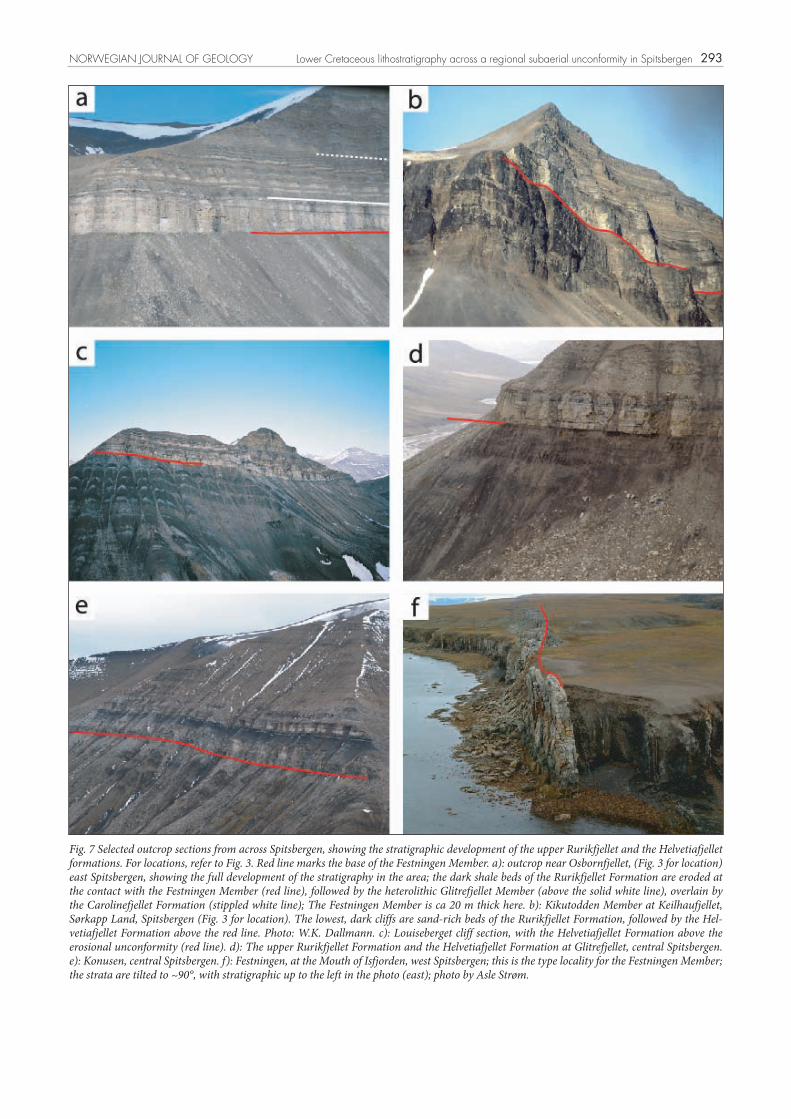
marginal marine or distal coastal plain mudstone above the fluvial Festningen Member, thus indicating an initial trans-gression above the alluvial plain (Fig. 15). This is a rather well marked lithologic boundary that can be mapped throughout the outcrop area in Svalbard. It should be stated, however, that in some outcrops the lower boundary is not easily recognized as one single and distinct marine transgressive surface, but appears more like a transitional lithological change from continental to marine facies.
The upper boundary of the Glitrefjellet Member is litholog-ically more diffuse than the lower boundary, being defined by the lower boundary of the overlying open-marine Caro-linefjellet Formation: “The lower boundary of the Caro-linefjellet Formation is defined at the base of the first coars-ening-upward unit or shale-sandstone pair which ends up with the typical, greenish-weathering sandstones of the Dalkjegla Member” (Mørk et al. 1999, p. 204).
The Glitrefjellet Member contains several thin sand-stone beds associated with coastal plain mudstone and/or restricted marine mudstone (Nemec 1992; Gjelberg & Steel 1995; Midtkandal 2002; Ahokas 2004; Midtkandal 2007; Midtkandal et al. 2007). Without high-resolution (microfossil-based) biofacies analysis, in order to distin-guish between coastal plain mudstone and inner shelf to open marine mudstone, it is difficult in many outcrops to find the boundary between the paralic Glitrefjellet Mem-ber and the open marine Carolinefjellet Formation (Midt-kandal et al. 2007). However, this is a problem related to the definition of the Caroline Formation, and not to the definition of the Glitrefjellet Member and the Helvetiafjel-let Formation (cf. Nystuen 1989, § 2.4.7, p. 13).
The apparent layer-cake stratigraphy of the Glitrefjellet Member likely reflects an aggradational depositional style of interfingering paralic facies belts along an undulat-ing coastline within the Spitsbergen domain during the overall sea level rise (Midtkandal et al. 2007, Midtkan-dal & Nystuen 2009). On a basin-wide scale (beyond the outcrop area on Svalbard), the architectural style is likely retrogradational, with onlaps onto the regional erosional unconformity at the base of the Helvetiafjellet Formation (cf. Gjelberg & Steel 1995).
DiscussionRecent stratigraphic and sedimentological studies of the Helvetiafjellet Formation and its relation to under- and overlying lithostratigraphic units have revealed the need for a revision of the formal lithostratigraphy, including
CLAY SILT SAND PEBBL.
VF F M C VC
Glitrefjellet
0
10
20
30
40
50
Hel
veti
afje
llet
Form
atio
n
Fest
nin
gen
Mem
ber
Glit
refje
llet
Mem
ber
Car
olin
efje
llet
Form
atio
nRu
rikf
jelle
tFo
rmat
ion Fig. 15 Sedimentological log from Glitrefjellet, central Spitsbergen.
This is the type locality for the upper, heterolithic portion of the Helvetiafjellet Formation. The fine grained intervals are partially scree-covered, and inferred to contain fine-grained material. See Fig. 8 for legend.
I. Midtkandal et al. NORWEGIAN JOURNAL OF GEOLOGY

301
the upper part of the Rurikfjellet Formation as well as the Helvetiafjellet Formation itself. The presence of a subaerial erosional unconformity at the base of the Hel-vetiafjellet Formation in the Svalbard outcrops calls for a distinction to be made between lithostratigraphic units belonging to the depositional system of the Rurikfjellet Formation and those of the overlying Helvetiafjellet For-mation. The Rurikfjellet depositional system is that of a marine shelf, regressive in its middle and upper parts, whereas the Helvetiafjellet depositional system represents environments ranging from fluvial to paralic, formed in response to fall and subsequent rise in relative sea level.
Concerning the Rurikfjellet and Helvetiafjellet forma-tions several depositional models have been suggested. Regarding the establishment of formal lithostratigraphic schemes, a genetic understanding of actual depositional systems is desirable; however, genetic depositional and sequence stratigraphic models should not govern the way the lithostratigraphic framework is defined (Hedberg 1976; Nystuen 1989). In the present revision we wish to turn the attention more to recorded lithostratigraphic features than to genetic models of deposition.
The term Ullaberget Member, as originally introduced by Różycki (1959), was re-defined by Birkenmajer (1975) and formally described by Mørk et al. (1999) as a sandstone-dominated member in the upper part of the Rurikfjellet Formation. This concept has turned out to be confusing, firstly because the original Ullaberget unit of upward-coarsening regressive shale to sandstone parasequences has not been documented in the Ullaberget section, sec-ondly, the deltaic sandstone recognized in the Ullaberget section belongs to the Helvetiafjellet depositional system, developed above the regional erosional unconformity that separates the Rurikfjellet and Helvetiafjellet formations. Both of these units, the sandy member in the upper part of the Rurikfjellet Formation and the new lower lithostrati-graphic unit of the Helvetiafjellet Formation need to be re-defined and new names applied. The upper member of the Rurikfjellet Formation also has a new stratotype. These units are the Kikutodden Member and the Louiseberget Bed of the Festningen Member, respectively, as discussed above and described in the Appendices.
The name Kikutodden Member should be used only for the upper, sand-dominated and upward-coarsening para-sequence set(s) of the Rurikfjellet Formation, not for the uppermost part of the Rurikfjellet Formation in those areas where it is characterised by thick shale and mudstone suc-cessions up to the contact beneath the Helvetiafjellet For-mation. The absence of the sand-rich upward-coarsening member in the upper part of the Rurikfjellet Formation may be due to the lack of sand deposition, or post-depo-sitional regional erosion. Hence, the lithostratigraphic ter-minology should strictly reflect lithostratigraphic proper-ties of the succession, not any presumptions concerning chronostratigraphic or sequence stratigraphic correlations of the various facies types.
The stratigraphic record of the Helvetiafjellet Forma-tion in Spitsbergen confirms the view of Parker (1967) that this formation can be subdivided in two main mem-bers, a fluvial sandstone-dominated member in the lower part and a marginal marine to paralic heterolithic mem-ber in the middle and upper parts, corresponding to the Festningen and Glitrefjellet members, respectively. The Louiseberget Bed is a local unit, formed by flooding of a relatively deep and narrow depression representing an incised valley. Correlative bay-head deltas may occur in similar settings in proximal reaches of other incised val-leys at the base of the Helvetiafjellet Formation. Outcrops of this formation are frequently used for educational pur-poses on Svalbard. The different facies and origin of the Louiseberget Bed compared to the remaining fluvially-dominated part of the Festningen Member are of interest when considering the depositional history of the succes-sion. A lithostratigraphic framework which distinguishes between these sandstone units is thus considered to be of practical value.
ConclusionThe present study has demonstrated the need to revise the current lithostratigraphy of the upper part of the Rurikfjellet and the Helvetiafjellet formations. This revi-sion can be summarized as follows:• The term Ullaberget Member (Różycki 1959;
Birkenmajer 1975; Dypvik et al. 1991a; Mørk et al. 1999) should be abandoned as a lithostratigraphic name.
• The Ullaberget Member should be substituted by the Kikutodden Member as the uppermost sand-domi-nated segment of the Rurikfjellet Formation, with its stratotype on Kikutodden in Sørkapp Land and hypostratotype on Strykejernet, Torell Land.
• The Ullaberget section in Nathorst Land is here defined as the stratotype for the new Louiseberget Bed of the Festningen Member, interpreted to represent a bayhead delta formed by initial transgression inundat-ing a local depression in the regional erosional surface at the base of the Helvetiafjellet Formation.
• The Festningen Member (Parker 1967) should be re-established as a formal lithostratigraphic unit instead of the informal status given to it by Mørk et al. (1999).
• The Glitrefjellet Member (Parker 1967) should be re-constituted as a formal member in the upper part of the Helvetiafjellet Formation, thus cancelling the proposed abandonment of this name by Mørk et al. (1999).
Acknowledgements: The authors wish to thank the following: Juha Aho-kas for support during field work on Spitsbergen, Winfried Dallmann, Tore Høy and Kjell-Sigve Lervik representing the Norwegian Commit-tee on Stratigraphy, for valuable comments on an earlier version of this manuscript, and John Gjelberg, William Helland-Hansen and Morten Smelror, referees as appointed by the Norwegian Journal of Geology, for insightful and thorough reviews. Statoil ASA is thanked for providing part of the funding that made the field work possible.
NORWEGIAN JOURNAL OF GEOLOGY Lower Cretaceous lithostratigraphy across a regional subaerial unconformity in Spitsbergen
302
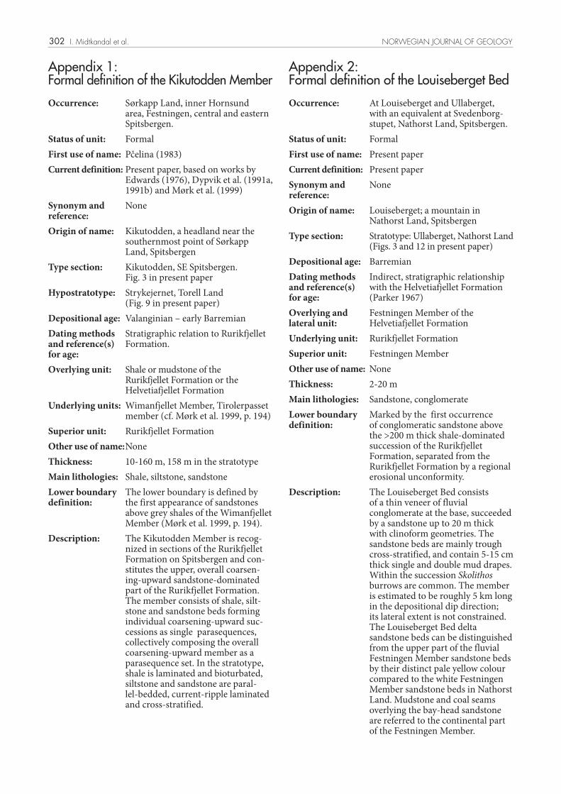
Appendix 1: Formal definition of the Kikutodden Member
Occurrence: Sørkapp Land, inner Hornsund area, Festningen, central and eastern Spitsbergen.
Status of unit: FormalFirst use of name: Pčelina (1983)Current definition: Present paper, based on works by
Edwards (1976), Dypvik et al. (1991a, 1991b) and Mørk et al. (1999)
Synonym and reference:
None
Origin of name: Kikutodden, a headland near the southernmost point of Sørkapp Land, Spitsbergen
Type section: Kikutodden, SE Spitsbergen. Fig. 3 in present paper
Hypostratotype: Strykejernet, Torell Land (Fig. 9 in present paper)
Depositional age: Valanginian – early BarremianDating methods and reference(s) for age:
Stratigraphic relation to Rurikfjellet Formation.
Overlying unit: Shale or mudstone of the Rurikfjellet Formation or the Helvetiafjellet Formation
Underlying units: Wimanfjellet Member, Tirolerpasset member (cf. Mørk et al. 1999, p. 194)
Superior unit: Rurikfjellet FormationOther use of name:NoneThickness: 10-160 m, 158 m in the stratotypeMain lithologies: Shale, siltstone, sandstoneLower boundary definition:
The lower boundary is defined by the first appearance of sandstones above grey shales of the Wimanfjellet Member (Mørk et al. 1999, p. 194).
Description: The Kikutodden Member is recog-nized in sections of the Rurikfjellet Formation on Spitsbergen and con-stitutes the upper, overall coarsen-ing-upward sandstone-dominated part of the Rurikfjellet Formation. The member consists of shale, silt-stone and sandstone beds forming individual coarsening-upward suc-cessions as single parasequences, collectively composing the overall coarsening-upward member as a parasequence set. In the stratotype, shale is laminated and bioturbated, siltstone and sandstone are paral-lel-bedded, current-ripple laminated and cross-stratified.
Appendix 2: Formal definition of the Louiseberget Bed
Occurrence: At Louiseberget and Ullaberget, with an equivalent at Svedenborg-stupet, Nathorst Land, Spitsbergen.
Status of unit: FormalFirst use of name: Present paperCurrent definition: Present paper Synonym and reference:
None
Origin of name: Louiseberget; a mountain in Nathorst Land, Spitsbergen
Type section: Stratotype: Ullaberget, Nathorst Land (Figs. 3 and 12 in present paper)
Depositional age: BarremianDating methods and reference(s) for age:
Indirect, stratigraphic relationship with the Helvetiafjellet Formation (Parker 1967)
Overlying and lateral unit:
Festningen Member of the Helvetiafjellet Formation
Underlying unit: Rurikfjellet FormationSuperior unit: Festningen MemberOther use of name: NoneThickness: 2-20 mMain lithologies: Sandstone, conglomerateLower boundary definition:
Marked by the first occurrence of conglomeratic sandstone above the >200 m thick shale-dominated succession of the Rurikfjellet Formation, separated from the Rurikfjellet Formation by a regional erosional unconformity.
Description: The Louiseberget Bed consists of a thin veneer of fluvial conglomerate at the base, succeeded by a sandstone up to 20 m thick with clinoform geometries. The sandstone beds are mainly trough cross-stratified, and contain 5-15 cm thick single and double mud drapes. Within the succession Skolithos burrows are common. The member is estimated to be roughly 5 km long in the depositional dip direction; its lateral extent is not constrained. The Louiseberget Bed delta sandstone beds can be distinguished from the upper part of the fluvial Festningen Member sandstone beds by their distinct pale yellow colour compared to the white Festningen Member sandstone beds in Nathorst Land. Mudstone and coal seams overlying the bay-head sandstone are referred to the continental part of the Festningen Member.
I. Midtkandal et al. NORWEGIAN JOURNAL OF GEOLOGY

303
The Louiseberget Bed is interpreted to have formed as a bay-head delta affected by tidal currents. It represents the earliest regressive infill of an incised valley that formed during a prior fall in relative sea-level.
References
Ahokas, J.M. 2004. Depositional environment, processes and sequence stratigraphy of the paralic Helvetiafjellet formation in Ullaberget, Southern Spitsbergen. Master Thesis, University of Oslo, Norway, 141 pp.
Ahokas, J.M., Midtkandal, I. & Nystuen, J.P. 2005. Depositional environment, processes and sequence stratigraphy of the paralic Helvetiafjellet Formation in Ullaberget, Southern Spitsbergen. In: Nakrem, H.A. (ed.): Abstracts and Proceedings of the Geological Society of Norway, 1.
Birkenmajer, K. 1975. Jurassic and Lower Cretaceous sedimentary formations of SW Torell Land, Spitsbergen. Studia Geologica Polonika, 44, 7-43.
Braathen, A., Bergh, S.G. & Maher, H.D. 1999. Application of a critical wedge taper model to the Tertiary transpressional fold-thrust belt on Spitsbergen, Svalbard. Bulletin of the Geological Society of America 111, 1468-1485.
Dallmann, W.K., Birkenmajer, K., Hjelle, A., Mørk, A., Ohta, Y., Salvigsen, O. & Winsnes, T.S. 1993. Geological Map Svalbard, Sheet C13G 1:100 000, with map by: Winsnes, T.S., Birkenmajer, K., Dallmann, W.K., Hjelle, A. and Salvigsen, O. Norsk Polarinstitutt, 73.
Dallmann, W.K., Hjelle, A., Ohta, Y., Salvigsen, O., Bjornerud, M.G., Hauser, E.C., Maher, H.D. & Craddodock, C., 1990. Geological Map Svalbard, Sheet B11G 1:100 000, Van Keulenfjorden, Norsk Polarinstitutt, temakart nr 15.
Dypvik, H., Nagy, J., Eikeland, T.A., Backer, O.K., Andresen, A., Haremo, P., Bjaerke, T., Johansen, H. & Elverhøi, A. 1991a. The Janusfjellet Subgroup (Bathonian to Hauterivian) on central Spitsbergen; a revised lithostratigraphy. Polar Research 9, 21-43.
Dypvik, H., Nagy, J., Eikeland, T.A., Backer, O.K. & Johansen, H. 1991b. The depositional conditions of the Bathonian to Hauterivian Janusfjellet Subgroup, Spitsbergen; a revised lithostratigraphy. Sedimentary Geology 72, 55-78.
Edwards, M.B. 1976. Depositional environments in Lower Cretaceous regressive sediments, Kikutodden, Sørkapp Land, Svalbard. Norsk Polarinstitutt Årbok 1974, 35-50.
Edwards, M.B., 1979. Sandstone in Lower Cretaceous Helvetiafjellet Formation, Svalbard: Bearing on Reservoir Potential of the Barents Shelf. American Association of Petroleum Geologists Bulletin 63, 2193-2203.
Gjelberg, J. & Steel, R. 1995. Helvetiafjellet Formation (Barremian-Aptian), Spitsbergen: characteristics of a transgressive succession. In Steel, R., Felt, V.L., Johannesen, E.P. and Mathieu, C. (eds.): Sequence Stratigraphy on the Northwest European Margin. Norwegian Petroleum Society (NPF). Special Publication 5, 571-573.
Grøsfjeld, K. 1992. Palynological age constraints on the base of the Helvetiafjellet Formation (Barremian) on Spitsbergen. Polar Research 11, 11-19.
Hedberg, H.D. (ed.) 1976. International Stratigraphic Guide: A Guide to Stratigraphic Classification, Terminology, and Procedure. John Wiley and Sons, New York, 200 pp.
Holbrook, J.M. 1996. Complex fluvial response to low gradients at maximum regression: a genetic link between smooth sequence-boundary morphology and architecture of overlying sheet sandstone. Journal of Sedimentary Research 66, 713-722.
Hurum, J.H., Milàn, J., Hammer, Ø., Midtkandal, I., Amundsen, H. & Sæther, B., 2006. Tracking polar dinosaurs - new finds from the Lower Cretaceous of Svalbard. Norwegian Journal of Geology 86, 397-402.
Kelly, R.A. 1988. Jurassic through Cretaceous stratigraphy of the Barents Shelf. In Harland, W.B. and Dowdeswell, E.K. (eds.): Geological Evolution of the Barents Shelf Region, 109-130. Graham and Trotman, London.
Midtkandal, I., Ahokas, J. & Nystuen, J.P. 2005. The lower Cretaceous Helvetiafjellet Formation, Spitsbergen: paralic environment at a ramp shelf from falling to rising sea level: Vinterkonferansen. Geological Society of Norway (NGF), Abstracts and Proceedings, Røros, Norway, 74-75.
Midtkandal, I., Nystuen, J.P. & Ahokas, J. 2006. Knickpoint control on fluvial to tidal sedimentation on a low gradient ramp shelf during fall and rise in sea level: 17th International Sedimentological Congress. International Association of Sedimentologists (IAS), Fukuoka Japan, 110.
Midtkandal, I., 2007. Depositional dynamics of an epicontinental basin; Lower Cretaceous on Svalbard. Ph.D. Thesis, University of Oslo, Oslo, 174 pp.
Midtkandal, I. & Nystuen, J.P. 2007. Sequence stratigraphy of a low-gradient, ramp shelf; the Lower Cretaceous on Svalbard. In: Brekke, H., Henriksen, H. and Haukdal, G. (eds): SEST - The First conference on Shelf Edge and Shoreline Trajectories, a Dynamic Approach to Stratigraphic Analysis. Geological Society of Norway, Tromsø, Norway, 330.
Midtkandal, I. & Nystuen, J.P. 2009, Depositional Architecture of a Low-gradient Ramp Shelf in an Epicontinental Sea: the Lower Cretaceous on Svalbard, Basin Research, doi: 10.111/j. 1365-2117.2009.00399.x
Mørk, A. 1978. Observations on the stratigraphy and structure of the inner Hornsund area. Norsk Polarinstitutt Årbok 1977, 61-70.
Mørk, A., Dallmann, W.K., Dypvik, H., Johannesen, E.P., Larssen, G.B., Nagy, J., Nøttvedt, A., Olaussen, S., Pchelina, T.M. & Worsley, D. 1999. Mesozoic lithostratigraphy. In: Dallmann, W.K. (ed.): Lithostratigraphic lexicon of Svalbard, Review and recommendations for nomenclature use. Upper Palaeozoic to Quaternary bedrock, 127-214. Norsk Polarinstitutt, Tromsø.
Mørk, A. & Smelror, M. 2001. Correlation and non-correlation of high order Circum-Arctic Mesozoic sequences. Polarforschung 69, 65-72.
Nathorst, A.G. 1910: Beiträge zur Geologie der Bäreninsel, Spitzbergens und des König-Karl-Landes. Bulletin Geologiska Institutionen Universitetet i Uppsala 10 (1910-1911), 261-416.
Nagy, J., 1970. Ammonite faunas and stratigraphy of Lower Cretaceous (Albian) rocks in southern Spitsbergen. Norsk Polarinstitutts Skrifter 152, 1 - 58.
Nagy, J., Løfaldli, M. & Backström, S.A. 1988. Aspects of Foraminiferal distribution and depositional conditions of Middle Jurassic to Early Cretaceous shales in Eastern Spitsbergen. Abhandlungen der Geologischen Bundesanstalts, Wien 30, 287–300.
Nemec, W., Steel, R.J., Gjelberg, J., Collinson, J.D., Prestholm, E. & Øxnevad, I.E. 1988. Anatomy of Collapsed and Re-established Delta Front in Lower Cretaceous of Eastern Spitsbergen: Gravitational Sliding and Sedimentation Processes. American Association of Petroleum Geologists Bulletin 72, 454 - 476.
Nemec, W. 1992. Depositional controls on plant growth and peat accumulation in a braidplain delta environment: Helvetiafjellet Formation (Barremian - Aptian), Svalbard. In McCabe, P.J. and Parrish, J.T. (eds.) Controls on the Distribution and Quality of Cretaceous Coals, 209-226. Geological Society of America Special Paper 267.
Nystuen, J.P. (ed.) 1989. Rules and recommendations for naming geological units in Norway, by the Norwegian Committee on Stratigraphy. Norsk Geologisk Tidsskrift 69, Supplement 2, 111.
Nøttvedt, A., Livbjerg, F., Midtbøe, P.S. & Rasmussen, E. 1993. Hydrocarbon potential of the Central Spitsbergen Basin. In Vorren,
NORWEGIAN JOURNAL OF GEOLOGY Lower Cretaceous lithostratigraphy across a regional subaerial unconformity in Spitsbergen

304
T.O., Bergsager, E., Dahl-Stamnes, Ø.A., Holter, E., Johansen, B., Lie, E. and Lund, T.B. (eds.): Arctic Geology and Petroleum Potential, 333-361. Norwegian Petroleum Society (NPF) Special Publication.
Parker, J.R. 1967. The Jurassic and Cretaceous sequence in Spitsbergen. Geological Magazine 104, 487-505.
Pčelina, T.M. 1983. Novye dannye po stratigrafii mezozoja archipelaga Spicbergen (New material on the Mesozoic stratigraphy of the Spitsbergen archipelago). In Krasilschikow, A.A. and Basov, V.A. (eds.): Geologija Spicbergena (The geology of Spitsbergen), 121-141. PGO “Sevmorgeologija”, Leningrad.
Różycki, S.Z. 1959. Geology of the north-west part of Torell Land, Vestspitsbergen. Studia Geologica Polonica 2, 1-98.
Steel, R., 1977. Observations on some Cretaceous and Tertiary sandstone bodies in Nordenskiöld Land. Norsk Polarinstitutt Årbok 1976, 43-67.
Steel, R. & Worsley, D. 1984. Svalbard’s post-Caledonian strata – an atlas of sedimentational patterns and palaeogeographic evolution. In Spencer, A.M. et al. (eds.): Habitat of hydrocarbons on the Norwegian continental margin, 109-135. Graham & Trotman, London.
Torsvik, T.H., Van der Voo, R., Meert, J.G., Mosar, J. & Walderhaug, J.H. 2001. Reconstructions of the continents around the North Atlantic at about the 60th parallel. Earth and Planetary Science Letters 187, 55-69.
Torsvik, T.H., Carlos, D., Mosar, J., Cocks, L.R.M. & Malme, T.N. 2002. Global reconstructions and North Atlantic paleogeography 440 Ma to Recent. In Eide, E.A. (ed.): BATLAS - Mid Norway plate reconstruction atlas with global and Atlantic perspectives, 18-39. Geological Survey of Norway. ISBN: 82-7385-106-0
Van Wagoner, J.C., Posamentier, H.W., Mitchum, R.M., Vail, P.R., Sarg, J.F., Loutit, T.S. & Hardenbol, J. 1988. An overview of sequence stratigraphy and key definitions. In Wilgus, C.K., Hastings, B.S., Posamentier, H.W., Ross, C.A., van Wagoner, J.C. and Kendall, C.G. (eds.): Sea-Level Changes-An Integrated Approach, 39-45. SEPM Special Publication 42.
Worsley, D. 2008. The post-Caledonian development of Svalbard and the western Barents Sea. Polar Research 27, 298-317.
I. Midtkandal et al. NORWEGIAN JOURNAL OF GEOLOGY