pprd east 2 - regional guidelines on flood risk...
TRANSCRIPT

Developed by the EU-funded Programme for Prevention, Preparedness and Response to Natural and Man-made Disasters in the EaP Countries - PPRD East 2
Regional Guidelines on Flood Risk Management
April 2016

Regional Guidelines on Flood Risk Management
April2016

3
Disclaimer
ThecontentsofthisdocumentarethesoleresponsibilityofitsauthorsandcaninnowaybetakentoreflecttheviewsoftheEuropeanUnion.
DraftingAuthors
MarcoMassabò,DisasterLossDataExpert
RobertoRudari,DisasterRiskPreventionExpert
TatianaBedrina,DisasterLossDataJuniorExpert
CoordinationandEditing
SergejAnagnosti,TeamLeader

4
Abbreviations 51. ExecutiveSummary 82. Introduction 103. LegalandInstitutionalFrameworkonFloodRiskManagementinEurope:theEUFloodsDirective123.1 MainRequirementsofEUFloodsDirective 123.2 UnitsofManagementandInstitutionalFrameworkinEUMemberStates 134. OverviewofLegalFrameworkofFloodRiskManagementinPartnerCountries 174.1 UnitsofManagementandInstitutionalFrameworkinPartnerCountries 215. PreliminaryFloodRiskAssessment(PFRA) 275.1 ScopeandobjectiveofPFRA 275.2 OverviewofPreliminaryFloodRiskAssessmentinEUMemberStates 285.2.1 GoodPracticesonPFRAinselectedEUMemberStates 305.3 PFRACurrentStatusofPreliminaryFloodRiskAssessmentinPartnerCountries 355.4 GuidanceandMethodologiesforPreliminaryFloodRiskAssessment 376. FloodHazardandRiskAssessment 476.1 TheScopeofFloodHazardandRiskAssessment 476.2 OverviewofFloodHazardandRiskAssessmentinEUMemberStates 486.2.1 GoodPracticesonFloodHazardandRiskAssessmentinselectedEUMemberStates 526.3 CurrentStatusofFloodHazardandRiskAssessmentinPartnerCountries 686.4 GuidanceandMethodologiesforFloodHazardandRiskAssessment 727. FloodRiskManagementPlans 75
7.1 TheScopeofFloodRiskManagementPlansbyEUFD 757.2 OverviewofCurrentStatusofFloodRiskManagementPlaninPartnerCountries 767.3 ReviewofInternationalGuidanceonFloodRiskManagementPlanning 797.3.1 WMOGuideforIntegratedFloodManagement 797.3.2 PPRDEast1RegionalRiskManagementPolicy 827.4 GuidanceforthePreparationofFloodRiskManagementPlans 848. Conclusions 87
9. References 90
10. Annex1–TypesofFloods 92
5
Abbreviations
BMO BasinManagementObjective,Armenia
BUWR BasinAdministrationsforWaterResources,Ukraine
CJSC CloseJointStockCompany
CMC CrisisManagementCentreofMES,Azerbaijan
CoE CouncilofEurope
CoM CabinetofMinistries
CORINE CORINELandCover(CLC)isageographiclandcover/landusedatabase
CP CivilProtection
CPESS CivilProtectionandEmergencySituations,Moldova
CRICUWR CentralResearchInstituteforComplexUseofWaterResourcesofMinistryofNaturalResourcesandEnvironmentalProtectionofBelarusRepublic
DEM DigitalElevationModel
DEMP DisasterEmergencyManagementPlans
DLD DisasterLossData
DM DisasterManagement
DRA DisasterRiskAssessment
DRM DisasterRiskManagement
DRR DisasterRiskReduction
EaP EasternPartnership
EEA EuropeanEnvironmentAgency
Eionet EuropeanEnvironmentInformationandObservationNetwork
EMA EmergencyManagementAgency,Georgia
ENPI EuropeanNeighbourhoodandPartnershipInstrument
EPIRB RegionalEUfundedprojectforEnvironmentalProtectionofInternationalRiverBasins
ERRA ElectronicRegionalRiskAtlas
EU EuropeanUnion
EUFD EUFloodsDirective
EWS EarlyWarningSysytem
EXZECO Coded’EXctractiondesZonesd’ECOulementmethod,France
FHRA FloodHazardandRiskAssessment
FRMP FloodRiskManagementPlan
GIS GeographicInformationSystem
GTZ GermanTechnicalCooperationAgency

6
INSPIRE InfrastructureforSpatialInformationintheEuropeanCommunity
ISO InternationalOrganizationforStandardization
IT InformationTechnology
IWRM IntegratedWaterResourcesManagement
JRC JointResearchCentreEU
JSC JointStockCompany
LRWM CommitteeofLandReclamationandWaterResources,Azerbaijan
MENR MinistryofEcologyandNaturalResources,Ukraine
MENR MinistryofEcologyandNaturalResource,Azerbaijan
MENRP MinistryofEnvironmentandNaturalResourcesProtection,Georgia
MES MinistryofEmergencySituations
MNP MinistryofNatureProtection,Armenia
MoA MinistryofAgriculture
MoF MinistryofFinance
MoH MinistryofHealth
MoIA MinistryofInternalAffairs,Moldova
MoNREP MinistryofNaturalResourcesandEnvironmentalProtection,Belarus
MSs EUMemberStates
MTAES MinistryofTerritorialAdministrationandEmergencySituations,Armenia
MTEF Mid-TermExpenditureFramework,Georgia
MATTM MinistryofEnvironment,LandandSeaProtection
NAG NationalAdvisoryGroup
NAoS NationalAcademyofScience
NASIGS ArmenianNationalAcademyofSciences,InstituteofGeologicalSciences,Armenia
NGO Non-GovernmentalOrganisation
NSDP NationalSustainableDevelopmentPlan,Georgia
NUTS NomenclatureofTerritorialUnitsforStatistics
OJSC OpenJointStockCompany
PFP PartnershipforPeace
PFRA PreliminaryFloodRiskAssessment
PMF ProbableMaximumFlood
PPP Public-privatepartnership
PPRDEast1Programme
EU-fundedProgrammeforthePrevention,PreparednessandResponsetoMan-madeandNaturalDisastersintheENPIEastRegion,Phase1
PPRDEast2Programme
EU-fundedProgrammeforPrevention,PreparednessandResponsetoNaturalandMan-madeDisasterinEaPCountries,Phase2

7
PRA PreliminaryRiskAssessment
PuP Public-publicpartnership
RBMP RiverBasinManagementPlan
SAWR StateAgencyofWaterResources,Ukraine
SCWE StateCommitteeofWaterEconomy,Armenia
SES StateEmergencyService,Ukraine
SHS StateHydro-MeteorologicalService,Moldova
SSCMC StateSecurityandCrisisManagementCouncil,Georgia
SWRA StateWaterResourceAgency,Azerbaijan
UHMC UkrainianHydro-MeteorologicalCentre
UHMI UkrainianHydro-MeteorologicalInstitute
UN UnitedNations
UNDP UnitedNationDevelopmentProgramme
UNESCO UnitedNationsEducational,ScientificandCulturalOrganization
UNISDR UnitedNationInternationalStrategyforDisasterRiskReduction
UoM UnitofManagement
USAID UnitedStatesAgencyforInternationalDevelopment
WFD WaterFrameworkDirective
WHO WorldHealthOrganisation
WISE WaterInformationSystemforEurope
WMO WorldMeteorologicalOrganisation
WRMA WaterResourcesManagementAgency,Armenia

8
1. ExecutiveSummary
TheaimofthisdocumentistoprovideguidelinesandreferencesforapproachingtheimplementationoftheEUFloodsDirective2007/60/EC1forPPRDEast2sixpartnercountries:Azerbaijan,Armenia,Belarus,Georgia,MoldovaandUkraine.Inparticular,theoperationaldescriptionofthedifferentphasesoftheEUFloodsDirectivearereportedandshownwiththeaidofsomeexperiencesofEuropeanCommunityMember States. TheseGuidelines are related toActivity areaA.1 of PPRD East2 programme capacitybuilding for the implementation of the EU Floods Directive and for addressing flood prevention. Thedocumentalsosummarizesthecurrentstatusofpracticesintheareaoffloodriskmanagementandtheapproximation to the EU Floods Directive (EUFD) in six partner countries as better described in thecountyprofiles.
Essentially,thefollowingdocumentationwasusedforpreparationthisGuidelines:
• Directive2007/60/ECoftheEuropeanParliamentandoftheCouncilof23October2007ontheassessmentandmanagementoffloodrisks,2007;
• IPAFloodsGuidelines for the implementationofEUFloodsDirectiveandMSsGoodPractices,2016;
• EUOverviewAssessmentofMemberStates’reportsonPreliminaryFloodRiskAssessmentandIdentificationofAreasofPotentiallySignificantFloodRisk,2015;
• EUOverviewofmethodologiesusedinpreparationofFloodHazardandFloodRiskMaps,2015;• PPRDEast1Risk/HazardAssessmentPolicyfortheENPIEasternRegion,2012;• WMOFormulatingaBasinFloodManagementPlan:ATool for IntegratedFloodManagement,
2007
SECTION1ExecutiveSummarySECTION2AnIntroductionandshortdescriptionofFloodsDirective2007/60/EC(EUFD).
SECTION3
Themainstepsfor implementationofEUFloodsDirective.TheconceptsofUnitsofManagementandInstitutionalframeworkareexplainedonexampleofEUMemberStates.
SECTION4
AnoverviewofFloodRiskManagementlegislation,UnitsofManagementandInstitutionalFrameworkinPartnerCountriesisgiven,developedonthebasisofCountryProfiles.
SECTION5
ScopeandobjectivesofEUFDfirststep-PreliminaryFloodRiskAssessment(PFRA).PFRAfromEuropeanperspectiveandcurrentstatusofPFRAinPartnerCountriesispresentedinthissection.Theoperationalphases of PFRAbasedon EUFDmethodology are provided; andPPRDEast 1 Risk/HazardAssessmentPolicyconceptsonpreliminaryassessmentsareoverviewed.
SECTION6
1(EUFloodsDirectiveRequirementsatlinkhttp://ec.europa.eu/environment/water/flood_risk/implem.htm)

9
TheFloodHazardRiskAssessmentandMapping(FHRM)isexplainedonthebasisofEUFDaswellastheEUmethodologies for its implementationandGoodexamplesofEUMemberStatesGermany, Irelandand Italy on its implementation. The current status of FHRM in Partner Countries is provided. SomegeneralnotesbasedonPPRDEast1Risk/HazardAssessmentPolicyareconsideredintheframeworkofFHRM.
SECTION7
ThissectionisdedicatedtotheFloodRiskManagementPlanmethodologyinEuropeanperspective.AnoverviewofcurrentstatusofFloodRiskManagementPlaninPartnerCountriesisgiven.WMOapproachon Flood Risk Management Plan and Regional Risk Management Process proposed by PPRD East 1projectisoverlooked.GeneralguidanceforthepreparationofFloodRiskManagementPlanisprovided.
SECTION8
Conclusions on Preliminary Flood Risk Assessment, Flood Hazard and Risk Mapping and Flood RiskManagement Plan established by EU Floods Directive. The overview of current status on Flood RiskManagement Plan and RiskManagement Process is provided of PPRD East2 Partner Countries.WMOapproach and PPRD East 1 project findings are presented, in order to give a wider spectrum ofreferencestothebeneficiariesofthisdocument.
SECTION9
References
Allsourcesarelistedinthereferencesection.
Annex
TheAnnexsectionprovidesacatalogueofFloodtypesaccordingtotheEUFloodsDirectiveterminology.
10
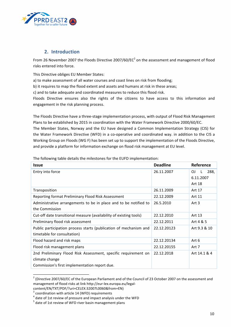
2. IntroductionFrom26November2007theFloodsDirective2007/60/EC2ontheassessmentandmanagementoffloodrisksenteredintoforce.
ThisDirectiveobligesEUMemberStates:a)tomakeassessmentofallwatercoursesandcoastlinesonriskfromflooding;b)itrequirestomapthefloodextentandassetsandhumansatriskintheseareas;c)andtotakeadequateandcoordinatedmeasurestoreducethisfloodrisk.Floods Directive ensures also the rights of the citizens to have access to this information andengagementintheriskplanningprocess.TheFloodsDirectivehaveathree-stageimplementationprocess,withoutputofFloodRiskManagementPlanstobeestablishedby2015incoordinationwiththeWaterFrameworkDirective2000/60/EC.TheMember States,Norwayand theEUhavedesignedaCommon Implementation Strategy (CIS) fortheWaterFrameworkDirective(WFD) inaco-operativeandcoordinatedway. inadditiontotheCISaWorkingGrouponFloods(WGF)hasbeensetuptosupporttheimplementationoftheFloodsDirective,andprovideaplatformforinformationexchangeonfloodriskmanagementatEUlevel.ThefollowingtabledetailsthemilestonesfortheEUFDimplementation:
Issue Deadline ReferenceEntryintoforce 26.11.2007 OJ L 288,
6.11.2007Art18
Transposition 26.11.2009 Art17ReportingformatPreliminaryFloodRiskAssessment 22.12.2009 Art11Administrativearrangements tobe inplaceand tobenotified totheCommission
26.5.2010 Art3
Cut-offdatetransitionalmeasure(availabilityofexistingtools) 22.12.2010 Art13Preliminaryfloodriskassessment 22.12.2011 Art4&5Publicparticipationprocess starts (publicationofmechanismandtimetableforconsultation)
22.12.20123 Art9.3&10
Floodhazardandriskmaps 22.12.20134 Art6Floodriskmanagementplans 22.12.20155 Art72nd Preliminary Flood Risk Assessment, specific requirement onclimatechangeCommission'sfirstimplementationreportdue.
22.12.2018 Art14.1&4
2(Directive2007/60/ECoftheEuropeanParliamentandoftheCouncilof23October2007ontheassessmentandmanagementoffloodrisksatlinkhttp://eur-lex.europa.eu/legal-content/EN/TXT/PDF/?uri=CELEX:32007L0060&from=EN)3coordinationwitharticle14(WFD)requirements4dateof1streviewofpressureandimpactanalysisundertheWFD5dateof1streviewofWFDriverbasinmanagementplans

11
2ndFloodhazardandriskmaps 22.12.2019 Art14.2Endof1stfloodriskmanagementcycle2nd Flood Risk Management Plans, specific requirement onclimatechange.3rdWaterFrameworkDirectiveRiverBasinManagementPlans.
22.12.2021 Art14.3&4
WithaReview/updateevery6yearsthereafterandReportingtotheCommission:3monthsafter.The mandate (MandateWorking Group F “Floods” 2016-20186, 2015) ofWG F describes objectives,tasks,deliverables,structureandorganizationofworkinggroup.Theobjectiveoftheworkprogrammeis to promote the information exchange amongMember States and other CISWorking Groups, andsupportcoordination,integrationandinterplayofWFDandFD.AmongmainobjectivesofWGFare:
- “information exchange amongMember States, the EUCommission and stakeholders on goodpractices,policy,researchandprojectdevelopmentsandnewapproachestoenhancefloodriskmanagementinEurope,
- feedback on the implementation of the EUFD and its reporting with a view to reaching acommonunderstandingontherequirementsfortheimplementationoftheEUFDandefficientandeffectivereporting,
- linkingwithrelatedactivitiesoftheCISatEUlevel,andwithotherCommissionorinternationalactivitiesforsupportoftheimplementation.”
ThetasksofWGFenvisageregular6-monthlymeetings,anumberofthematicworkshops,reviewandamendment of relative documentation, input into other CIS and EU-Level activities (research, Riskassessment andmanagement and civil protection activities lead byDG ECHOCivil Protection and EUClimateChangeAdaptationStrategy),introductionofavoluntarypeerreviewprocess.TheofficialkeydocumentationisprovidedontheEuropeanCommissionweb-siteatlinks:
− onFloodsDirective2007/60/EChttp://ec.europa.eu/environment/water/flood_risk/key_docs.htm
− onWaterFrameworkDirective2000/60/EChttp://ec.europa.eu/environment/water/water-framework/index_en.html
PPRD EAST 2 partner countries have various FloodManagement practices at national level. Some ofthem have already developed Flood Management Plans in the framework of various internationalcooperationprojects.ButoftentheseinitiativesaredesignedforlimitedareasorparticularbasinsandarenotnecessarilycomplianttotheFloodsDirective.ArevisionofcurrentstatusofFloodManagementpractices of partner countries will help to further improve existing methods and development ofproceduresfortheapproximationtotheFloodsDirective2007/60/EC.
6(MandateWGFatlink:https://circabc.europa.eu/webdav/CircaBC/env/wfd/Library/floods_programme_1/b_wg_f_on_floods/18th%20meeting%20-%2022-23_10_2015/Documents/WG_Floods_Draft%20Mandate%202016_18%20v.1.1.pdf)

12
3. Legal and Institutional Framework on Flood Risk Management inEurope:theEUFloodsDirective
This section gives an introduction to EU Floods Directive and describes its aim and main steps ofimplementation.TheoverviewoflegalframeworkofFloodRiskManagementinPPRDEast2sixpartnercountriesisalsoprovidedbasedonlastupdated(2015)CountryProfilereports.
3.1 MainRequirementsofEUFloodsDirectiveTheEuropeanFloodsDirective(EUFD)hasaimto7:
− establish a framework for the assessment and management of flood risks, aiming at thereduction of the adverse consequences for human health, the environment, cultural heritageandeconomicactivityassociatedwithfloodsintheCommunity;
− establishaprocessforproducingfloodhazardmapsandfloodriskmapsinordertoaddressthefloodrisk;
− in the flood riskmanagementplansaddressall aspectsof flood riskmanagement focusingonprevention,protection,preparedness, includingfloodforecastsandearlywarningsystemsandtakingintoaccountthecharacteristicsoftheparticularriverbasinorsub-basin.
TheapproachtofloodriskmanagementinEUMemberStatesisdividedinthreemainsteps,asfollows8:
1. EU Member States undertake a preliminary flood risk assessment of their river basins andassociatedcoastalzones,toidentifyareaswherepotentialsignificantfloodriskexists-by2011.
2. Whererealrisksofflooddamageexist,floodhazardmapsandfloodriskmaps forsuchareasmustbedeveloped-by2013.Thesemapsidentifyareaswithamediumlikelyhoodofflooding(atleasta1in100yearevent)andextremeeventsorlowlikelihoodevents,inwhichexpectedwaterdepthsareindicated. In the areas identified as being at risk the number of inhabitants potentially at risk, theeconomicactivityandtheenvironmentaldamagepotentialareindicated.
3. Finally,floodriskmanagementplansmustbedrawnupforthesezones-by2015.Theseplansaretoincludemeasurestoreducetheprobabilityoffloodinganditspotentialconsequences.Theywilladdress all phases of the flood risk management cycle but focus particularly on prevention (i.e.preventingdamagecausedbyfloodsbyavoidingconstructionofhousesand industries inpresentandfuture flood-prone areas or by adapting future developments to the risk of flooding), protection (bytakingmeasurestoreducethelikelihoodoffloodsand/ortheimpactoffloodsinaspecificlocationsuchas restoring floodplainsandwetlands) andpreparedness (e.g.providing instructions to thepubliconwhat todo in theeventof flooding).Duetothenatureof flooding,muchflexibilityonobjectivesandmeasuresarelefttotheMemberStatesinviewofsubsidiary.
Theschemebelow(Figure1)providesthethreephasesofEUFloodsDirectivenamely:• PreliminaryFloodRiskAssessment(PFRA)
7(ECTechnicalReport(2014-078)LinksbetweentheFloodsDirectiveatlinkhttps://circabc.europa.eu/sd/a/2e917bbb-abff-41ac-b6fc-0fc91bf0347d/inks%20between%20the%20Floods%20Directive%20and%20Water%20Framework%20Directive%20-%20Resource%20Document.pdf)8(EUFloodsDirectiveRequirementsatlinkhttp://ec.europa.eu/environment/water/flood_risk/implem.htm)

13
• FloodHazardMapsandFloodRiskMaps(FHM&FRM)• FloodRiskManagementPlans(FRMP)
Figure1.FlowchartwithEUFDimplementationphases
The above-listed stage process need to be reviewed every 6 years in a cycle coordinated andsynchronizedwiththeWaterFrameworkDirective(WFD)implementationcycle.TheFDplanningcycleisshowninFigure2.
Figure2.TheEUFloodsDirectiveplanningcycle.
3.2 Units of Management and Institutional Framework in EU MemberStates
The EU Floods Directive indicates that Member States may make use of the administrativearrangementsmadeunderArticle3oftheWaterFrameworkDirective.However,differentcompetentauthoritiesmaybeappointedbyMemberStatesfortheFloodsDirective.
RiverBasinDistrictsAs defined by the European Commission, "River Basin Districts (RBDs) are the main units for themanagementofriverbasinsandhavebeendelineatedbyMemberStatesunderArticle3oftheWaterFrameworkDirective(WFD).FortheFloodsDirectiveMemberStatesweregiventhechoicetouseeithertheWFDRiverBasinDistricts,ortodesignateotherUnitsofManagement(UoM)forspecificriverbasins

14
or stretches of coastal areas under article 3 of that Directive. For themajority of RBDs, EUMemberStates used the same ones as for theWFD. The geographic area of some RBDs spanmore than onecountry (such as the Danube) and these are known as International RBDs. Others (theminority) arecontainedcompletelywithinacountryandareknownasNationalRBDs."UnitsofManagementTheUoMconsist inboundariesidentifiedtomanageriversand/orcertaincoastalareas.ThedefinitionoftheUoMcanbebasedongeomorphologicaloradministrativecriteria.ObjectasdefinedintheEUFD:Maybe individualriverbasinsand/orcertaincoastalareas;maybeentirelywithinnationalbordersormaybepartofaninternationalUnitofManagementorInternationalRiverBasinDistrict.TheFloodsDirective(Article3.2)allowsMemberStatestoidentifyUnitsofManagementdifferentfromthe River Basin Districts used for the Water Framework Directive. Competent Authorities will berequiredforeachnationalRBDorUoMandfortheportionofanyinternationalRBDorUoMlyingwithinitsterritory.The EUFD implementation process needs to start from a complete definition of the command andcontrolchainforFloodManagement;mappingofinstitutionscompetentinalltheaspectsofEUFDandunderstandingpotentialconflictswithotherEUDirectives/Nationalplansisapriorityandthefollowingaspectshavetobeanalyzed:
• regulatoryframework(who,what,when,where,why)• institutionalsubdivisionofpowers(identificationofdutyholdersinthewatermanagementand
civilprotectionsystems)• institutionsincharge• inter-institutionalrelations• mandateandresponsibilitiesofstakeholders• internationalagreementsonfloodmanagement(bilateral,multilateral,regional)
Theanalysisshouldbeabletodefinetheframeworkinsidewhichitisclearlypossibletoidentifywho:• isinchargeforcoordinatingthePFRA;• hasthetechnicalknowledgeformanagingPFRAdataeventuallyavailable;• hastheinformationatlocal/catchmentlevel.
In theory, the institutions involved in the PFRA can be various, and an appropriate coordination andharmonization of their activities should be done, eventually developing a capacity building phasespecificallyorientedtothistask.Only afterwards can properly start the implementation of the operational procedures aimed topreliminaryassessareaswithpotentialsignificantfloodriskandtodevelopachainofstudiesuponthemwhichwillbeconcludedwiththeproductionofproperoperativefloodmanagementplans.It has to be underlined that EUFD recommend to widen the analysis with the updated overview ofongoingorcompletedrelevantinitiativesregardingthelocalapproximationtoEUFD,withattentiontobepaidonpossiblesynergies.ObjectasdefinedintheEUFD:Preamble,point17:DevelopmentofriverbasinmanagementplansunderDirective2000/60/ECandofflood riskmanagementplansunder thisDirectiveareelementsof integrated riverbasinmanagement.
15
Thetwoprocessesshouldthereforeusethemutualpotentialforcommonsynergiesandbenefits,havingregard to the environmental objectives of Directive 2000/60/EC, ensuring efficiency and wise use ofresourceswhile recognizing that the competent authorities andmanagement unitsmight be differentunderthisDirectiveandDirective2000/60/EC.EUInstitutionalFrameworkDetectionSchemeAnalysis of institutions that can be appointed for Coordination, Preparation and Production ofpreliminaryfloodriskassessment,floodmapsandfloodriskmanagementplans,includinginternationalcoordinationintransboundaryunitsofmanagemente/oreportingtotheEU:
§ legalstatusofeachcompetentauthority:• thelegislationestablishingthecompetentauthority• the legislation laying down the duties of the competent authority in relation to the
FloodsDirective• the legislation laying down other duties of the competent authority relevant (but not
directlyrelated)totheEUFD§ institutional relationships established to ensure co-ordinationwhere the competent authority
actsasaco-ordinatingbodyforothercompetentauthorities§ whenmorethanonecompetentauthorityisestablished:
• list showing the coordinatingbodyand the relationshipbetween the coordinatingbodyandtheauthorities
• whoseactivities it iscoordinating,andrelationshipswithotherbodiescarryingouttasks linkedto implementationoftheplans including, forexample,civilprotectionagenciesandearlywarningsystems
§ international relationships: details established to ensure coordination where a river basindistrictorotherunitofmanagementcoverstheterritoryofmorethanoneState
§ detailsofanyotherinstitutionthatcouldperformarelevantroleinwatermanagement,spatialplanning, flood forecasting, flood warning and civil protection, in addition to the scientificcommunity
§ detailsofcompletedandongoinginitiativesregardingtheEUFD.InstitutionalframeworkforEUFDinEUMemberStates
The European Environment Agency (EEA) is an agency of the European Union. Its role is to providesound, independent information on the environment. EEA is a major information source for thoseinvolved in developing, adopting, implementing and evaluating environmental policy, and also thegeneralpublic.Currently,theEEAhas33membercountries.
TheregulationestablishingtheEEAwasadoptedbytheEuropeanUnionin1990.Itcameintoforceinlate1993 immediatelyafter thedecisionwastakento locatetheEEA inCopenhagen.Workstarted inearnest in 1994. The regulation also established the European Environment Information andObservationNetwork(Eionet).
EEA'smandateis:

16
§ Tohelp theCommunityandmembercountriesmake informeddecisionsabout improving theenvironment, integrating environmental considerations into economic policies and movingtowardssustainability;
§ TocoordinatetheEuropeanenvironmentinformationandobservationnetwork(Eionet).
The European Environment Agency and the European Commission (DG Environment, Joint ResearchCentre and Eurostat) created theWater Information System for Europe –WISE9. Themain roles andresponsibilitiesoftheEEA’saretohoststheWaterDataCentreandthethematicWISEwebpages.
TheauthoritiesresponsiblefortheimplementationoftheFloodsDirectiveinallEUMemberStatesarelistedinWISEwebsite.
9(EEAFloodsDirectivevieweratlinkhttp://www.eea.europa.eu/themes/water/interactive/floods-directive-viewer)
17
4. Overview of Legal Framework of Flood Risk Management in PartnerCountries
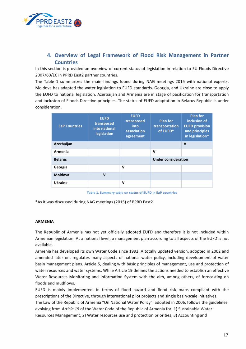
InthissectionisprovidedanoverviewofcurrentstatusoflegislationinrelationtoEUFloodsDirective2007/60/ECinPPRDEast2partnercountries.The Table 1 summarizes the main findings found during NAG meetings 2015 with national experts.MoldovahasadaptedthewaterlegislationtoEUFDstandards.Georgia,andUkraineareclosetoapplytheEUFDtonational legislation.AzerbaijanandArmeniaareinstageofpacificationfortransportationandinclusionofFloodsDirectiveprinciples.ThestatusofEUFDadaptationinBelarusRepublicisunderconsideration.
EaPCountries
EUFDtransposedintonationallegislation
EUFDtransposed
intoassociationagreement
Planfortransportation
ofEUFD*
Planforinclusionof
EUFDprovisionandprinciplesinlegislation*
Azerbaijan V
Armenia V
Belarus Underconsideration
Georgia V
Moldova V
Ukraine V
Table1.SummarytableonstatusofEUFDinEaPcountries
*AsitwasdiscussedduringNAGmeetings(2015)ofPPRDEast2
ARMENIA
The Republic of Armenia has not yet officially adopted EUFD and therefore it is not included withinArmenianlegislation.Atanationallevel,amanagementplanaccordingtoallaspectsoftheEUFDisnotavailable.ArmeniahasdevelopeditsownWaterCodesince1992.Atotallyupdatedversion,adoptedin2002andamended later on, regulatesmany aspects of national water policy, including development of waterbasinmanagementplans.Article5,dealingwithbasicprinciplesofmanagement,useandprotectionofwaterresourcesandwatersystems.WhileArticle19definestheactionsneededtoestablishaneffectiveWater ResourcesMonitoring and Information Systemwith the aim, among others, of forecasting onfloodsandmudflows.EUFD is mainly implemented, in terms of flood hazard and flood risk maps compliant with theprescriptionsoftheDirective,throughinternationalpilotprojectsandsinglebasin-scaleinitiatives.TheLawoftheRepublicofArmenia“OnNationalWaterPolicy”,adoptedin2006,followstheguidelinesevolvingfromArticle15oftheWaterCodeoftheRepublicofArmeniafor:1)SustainableWaterResourcesManagement;2)Waterresourcesuseandprotectionpriorities;3)Accountingand
18
assessmentofwaterresources;4)FormationofWaterResourcesDemand;5)Relationspertainingtowaterbasinmanagement.
AZERBAIJAN
The water sector development of the Azerbaijan is historically focused on the irrigation system andfloodprotectionmorethanpreventionandpreparedness.WaterresourcesmanagementisregulatedbytheWaterCoden418-IGof26December1997.
TheWaterCodeestablishesthatappropriatesnormativesecondaryactsonfloodmanagementshouldbepreparedbyrelevantexecutiveauthorities;however,noneoftheexisting legalandregulatoryactsconsider flood risk assessment and integrated flood risk management planning. Water Code ofAzerbaijanrequiresasignificantupgradeandalignmenttotheEUstandards,includingaclearconceptoftheprincipleofbasinmanagement,integratedwaterresourcemanagementandthedefinitionoffloodrisk.
SecondaryLawundertheWaterCodeneedstobedevelopedinorderto includeEUFDprovisionsandprinciple innational regulation, startingwitha clear inclusionof thebasinmanagementprincipleandthe concept of flood risk assessment. Some activities in the direction of improving the legal andinstitutionalframeworkareinprogress,i.e.:adraftwaterstrategyhasbeenpreparedbutnotapprovedyet; theAzerbaijanStateCommission forcooperationwithEU10haselaboratedanactionplan for theperiod2015-2020fortheharmonizationoflegalframeworkofAzerbaijantotheEUacquis.TheActionPlanshouldincludeachaptersdedicatedtoWaterResourcesManagement(keyfiguresareMENRandSAWRofMES)andinclusionoftheprovisionofEUFloodsDirectiveintonationallegislation.
BELARUSBelarus has not yet officially transposed EUFD in its national legal framework and there is noharmonization among the existing Belarus Program Engineering ProtectionMeasures from Flood forpopulationandagriculturefor2005-2010andotherEU-directivesincludingEUFDandWaterFrameworkDirective(WFD).EUFDhasbeenmainlyimplementedthroughinternationalprojectsandsinglebasin-scaleinitiatives.ThemainactorintheimplementationoftheseprojectsistheCentralResearchInstituteforComplexUseofWater Resources (CRICUWR) under theMinistry of Natural Resources and Environmental Protection(MoNREP).TheWaterCodeof theRepublicofBelarushasbeendeveloped in2013by theMoNREPentered intoforceon21May2015.TheWaterCodeusesapproachesincludedintheWFDandparticularlytheuseofa“riverbasinmanagementprinciple”intheformofBasinCouncils.Thehydro-meteorologicaldataprovisionhasbeenaddressedbythePresidentialDecreeofJanuary23,2007№75OntheimplementationoftheLaw"Onhydrometeorology”approvingtheregulationsontheprovision of hydro-meteorological data of the MoNREP of Hydro- Meteorological information notincludedintheStateHydro-meteorologicalService,theregulationsontheproceduresofstatecontrolinthe field of hydro-meteorological activities, the regulations on the procedure of managing the stateregister of producers of hydro-meteorological information and certificate their registration as hydro-meteorologicalinformationproviders,theregulationontheestablishmentanddesignationofguarding
10PermanentCommissionChairedbytheMinistryofEconomyandIndustry

19
zonesaroundfixedpointsofobservationofthestatenetworkofhydrometeorologicalobservations,aswellastherequirementsfortheirprotectionanduse.GEORGIAGeorgiahasalongtraditionofshapingitslawsanddecreestakingasanexampletheEUlegislation.AsaresultofthatmanypiecesoflegislationarealreadyorientedtowardstherequirementsoftheEUFD.HoweverGeorgiahasnotyetofficially transposedEUFD in itsnational legal framework,but startedaseries of preparatory actions in order to approximate to the EUFD. Georgia signed the EU – GeorgiaAssociationAgreementandAssociationAgenda,whichaimtopromotethedialogueandapproximationofEUlegislationonitemssuchascivilprotectionandfloodsmanagement,thisagreementhastheEUFDamongst its priority. Within such framework the Ministry of Environment and Natural ResourcesProtection (MENRP) through itsDRRoffice initiated a series of consultationswith EUMember StatesexpertstoassessthegapsintheGeorgianlegislationinordertoreachtheapproximationthatresultedinthedraftingofaRoadMapfortheapproximationtotheEUFD.GeorgiaisseekingforsupportintheRoadMapimplementation.Georgia legislation isundergoingdeepchangesall possibly connectedwith theEUFD.Mentioning themostrelevantones:theLawonCivilSecurityenteredinforcein2014thatforeseesenhancedmandatesforthenewlyconstitutedEmergencyManagementAgency(EMA)withintheMinistryofInternalAffairsmanyofwhichrelatedtofloodriskassessmentandfloodriskmanagement.InparticularEMAisnowintheprocessofdefiningsub-legislationthatincludescontentofDisasterEmergencyManagementPlans(DEMP) including floods. Depending on the decision taken in drafting such sub-legislation DEMP cancoverasubstantialpartof thecontents included inaFloodRiskManagementPlan (FRMP) that is thefinalgoaloftheEUFD.ThenewlycreatedStateSecurityandCrisisManagementCouncil (SSCMC) is intheprocessofdraftingand getting approved both a National DRR Strategy and a DRR Action Plan that will include theapproximationtotheEUFDbytheendofthe2015.GeorgiaisalsoabouttoadoptanewWaterCodedevelopedbytheMinistryofEnvironmentandNaturalResourcesProtection(MENRP)thatincludesimportantlinkswiththeWaterFrameworkDirective(WFD)aswellaswithEUFD.All these pieces of legislation aim at an increasing flood protection level, this intention is alsorepresented in the annually updatedMid-Term Expenditure Framework (MTEF) for 2013-2016wheredisasterpreventionisoneoftheprioritiesintheEnvironmentSector.TheMinistry of Economy and Sustainable Development is also in the process of drafting a NationalSustainable Development Plan (NSDP) that has environmental issues and risk derived from naturalhazardsintegratedinit.However, despite the favorable legislative setup all these Laws, strategies and plans lack in inter-institutionalcoordinationandthis leadssometimestoanunclearorconflictingrolesandmandatesofthedifferent institutionalactors.This leadstodifficulties infindingamandatedinstitutionorbodyforthedevelopmentofacoordinatedFloodManagementPlan(FMP)thathasthenaturalcatchmentasatargetareaanddomain.MOLDOVAWaterandfloodmanagementlegislationofMoldovahasbeenextensivelytransformedinthelastyearsandharmonizedtoseveralEUDirectives.TheWaterLawnr.272of23December2011,effectivesinceOctober26th2013,partially,thoughsubstantially,transposedthefollowingdirectives:

20
− WaterFrameworkDirective(WFD)no.2000/60/ECof23December2000(WFD),− UrbanWasteWaterDirectiveno.91/271/EECof21May1991,− NitrateDirectiveno.91/676/EECof12December1991,− BathingWaterDirectiveno.2006/7/ECof15February2006and− FloodsDirectiveno.2007/60/ECof23October2007.
Specifically, the art. 49 of Water Law 272 provides that flood risk management is regulated by adedicatedsub-lawwhichhasbeenelaboratedandapprovedasGovernmentalRegulationonFloodRiskManagement no.887 of 11 November 2013. The Regulation identifies the Ministry of Environment(MoE)asaresponsiblebodyforthe implementationofthe legalact.TheRegulation issubstantially inlinewith the requirementsof EUFD for thepreparationof Preliminary FloodRiskAssessment (PFRA),Flood Hazard Mapping (FHM) and Flood Risk Mapping (FRM) and Flood Risk Management Plans(FRMPs). Italsosetsa reviewandupdatingprocessof theplansandamonitoringmechanismfor theimplementationofthemeasures.ThemaindiscrepancywithEUFDisthattheRegulationdoesnotsetatimelimitforcompletingPFRA,FHM,FRM,FRMPs.UKRAINEInthewakeoftheassociationagreementbetweenUkraineandEUsignedon17September2014,EUFDwas object to an action plan approved by theDecision of Cabinet of theMinisters 419 on 25March2015,aswellasthePlanofImplementationofDirective2007/60/EUwasapprovedbytheResolutionoftheCabinetofMinistersofUkraine132on25February2015.ThisplanstatesthatananalysisofcompatibilityofUkrainianbodyoflawwiththeEUacquiscommunalwill last until the end of 2015. Theworking group specificallyworking on EUFD approximation underStateEmergencyService(SES)leadershipmustcoordinateitsactivitywithanoverarchinggroupledbyMinistryofEcologyandNaturalResources(MENR)ontheWaterFrameworkDirective(WFD).TheAssociationAgreementamong theEuropeanUnionand theEuropeanAtomicEnergyCommunityandtheirmemberstates,oftheonepart,andUkraine,oftheotherpartcontainstheroadmapfortheEUFDimplementation,namely:
• twoyearssincetheratificationtoestablishtheunitsofmanagement• fouryearssincetheratificationtocompletethepreliminaryfloodriskassessment• sixyearssincetheratificationtocompletefloodhazardandfloodriskmapping• eightyearssincetheratificationtodraftfloodriskmanagementplans.
Key implementersofEUFDwillbeSES(nationalcoordinator),MENR–beingthemainauthority inthesystemofcentralexecutivebodiesintheformationandrealizationofstatepolicyinthefieldofwatermanagement–andtheStateAgencyforWaterResources(SAWRisthecentralexecutivepowerbody,whoseactivityiscoordinatedbytheCabinetofMinistersofUkrainethroughtheMinisterofEcologyandWater Resources and who carries out the state policy in the field of water management and hydrotechnicallandreclamation,surfacewaterresourcesmanagement,useandrecovery).For FloodHazard (FHM)and FloodRiskMapping (FRM), theUkrainianHydro-Meteorological Institute(UHMI)willbe themain implementer.Theneededhydro-meteorologicaldatawillbeprovidedby theUkrainianHydro-MeteorologicalCentre (UHMC).Waterobjects, theirareas that the inundationmapsandfloodriskmapsaredevelopedfor,aswellastheorderoftheirdevelopmentwillbedeterminedbytheSAWR.Taking into account that theNationalAcademyof Sciences - InstituteofMathematicalMachines andSystemProblemshasitsownmethodologyforcalculatinganddevelopinginundationmaps(seeclause

21
4.2.1 below), it is reasonable to involve it alongsidewith UHMC in developing suchmapswithin theframeworkoftheEUFloodsDirective.TobecompliantwithEUFD,effortswillbethentakentoupgradeandoptimizethenational legislativeframework(e.g.,theUkrainianWaterCode)andthestructureofMinistriesandagenciesrelatedtothematter(e.g.,thehydro-meteorologicalbodies).
4.1 Units of Management and Institutional Framework in PartnerCountries
The organizational structures, rules and norms of Institutional Framework are vary from country tocountry. Institutionalstructuresareessential tohavemechanisms fordialogueandco-ordination.TheUnitofManagementisakeyconceptofbothEUFDandEUWFDandbothDirectivesrequiretodefineaunit of management and associated management authority/organization based on the river basinmanagementprinciple.Trans-nationalriverbasinshaveinter-institutionalriverbasincouncil/committeefor the purposes of developing and implementing River Basin Management Plan and Flood RiskManagementPlansatbasinlevel.
BelowashortdescriptionoforganizationalstructuresandUoMsofeachpartnercountryispresented.
ARMENIA
InstitutionalFramework
The competent authority for water management in Armenia is the Water Resources ManagementAgency(WRMA)bytheGovernmentofArmenia.TheWRMAwithits6BasinManagementOrganizations(BMOs)operatesundertheMinistryofNatureProtection(MNP)andisresponsiblefordevelopmentandimplementationofWaterBasinManagementPlans(WBMPs),alongwiththeothermaintasksrelatedtowater resourcesmanagement in compliance with the NationalWater Policy and the NationalWaterProgramme,andthedefinitionsandprescriptionsoftheWaterFrameworkDirective.TheMinistryofAgriculturehasbeenrecognized(16August2007)asstategoverningauthorizedbodyfororganizationandimplementationofmeasuresforpreventionandeliminationofadverseimpactonriverwatersforeseenbytheWaterCode.Specifically,theMinistryofAgricultureisresponsiblefor:
• anti-floodmeasuresimplementation;• inventoryofriversanddrainagesystemsinthecountry;• creationofthedatabasereflectingtheactualstate;• developmentofprogramsonanti-floodmeasures;• compilingdesigndocumentationandorganizationofworks,operationandmaintenanceofbank
protectionstructures.TheMinistryofAgriculturecollaborateswithregionalgovernment,communitymunicipalities,aswellaswith state governing bodies and other parties that have experience and role in sector of anti-floodmeasures. The Ministry of Territorial Administration and Emergency Situations (MTAES) annuallypresentsproposalstotheMinistryofAgricultureonimplementationofnecessarypreventivemeasuresthathavebeendevelopedasa resultof studiesof floodpronehazardoussegmentsofbedsof rivers,drainagesystemsandfloodcontrolsystems.State Committee of Water Economy (SCWE) is a state body within the structure of the Ministry ofAgriculture.SCWEdevelopsandimplementsthepolicyoftheGovernmentoftheRepublicofArmeniainthe area of water systems that are considered as state property and non-commercial water supply

22
systems management and utilization, including all the functions associated to the hydro technicalstructure.
UnitsofManagement
AccordingtotheWaterCodeoftheRepublicofArmenia,theNationalWaterPolicyandtheNationalWaterProgram,theWRMAhasestablishedBasinManagementObjectives(BMOs)(oneforeachmajorArmenianbasin);however,theBMOsaredivisionswithinWRMAratheracoordinationbodyamongseveralinstitutionsandstakeholders.
AZERBAIJAN
InstitutionalFramework
TheOrganization Charter defined by the President and Cabinet ofMinistries is a key element of theAzerbaijanlegislation.AccordingtotheCharter,theresponsiblebodyforproposingnewNationalWaterPolicyfortheapprovaltoGovernment(CabinetofMinisters)andtheParliament(MilliMajlis)are:theMinistry of Ecology and Natural Resource (MENR), which also acts as owner of the country waterresourcesbyapprovingwaterutilizationpermit,andtheMinistryofEmergencySituation(MES).MENRisresponsiblealsoforenvironmentalmanagementandmonitoring,includingmonitoringofatmosphere(precipitationandothervariables)surfaceandgroundwater(qualityandquantity),weatherforecasting,climatechangeadaptationandregistrationofenvironmentaldata.
Water management is distributed among multiple actors, namely: State Water Resources Agency(SWRA)of theMES,Ministryof Energy and LandReclamation andWaterManagementOJSC .Azersuoperateswatersupply,whileWaterUserUnionsdistributeswatertofarmersforirrigationpurposes.
The SWRA is the executive body for the improvement of water resources management. SWRAcontinuously provides verification of the technical condition of water reservoirs and other hydro-technical facilities,monitoringofwater bodies, surfacewater and groundwater andwater systems inthecountryanditisresponsibleforsafetyandsecurityofreservoirsofnationalimportance.
SWRAofMES,MENRandOJSCareresponsibleforfloodmanagement.
The National Department for Hydro-meteorology of MENR is responsible for meteorological andhydrological forecastandmonitoring.Themonitoringand forecastingdivisionhaveagoodnumberofforecasters.TheDivisionproducesregularmeteorologicalbulletinscontainingwarnings.
UnitsofManagement
The currentWater Code both includes the river basinmanagement principles and the administrativeborder management criteria; it does not clarify which criteria must be used and, as a result, theadministrative border criteria is the one adopted in practice. Regional EU funded programme forEnvironmentalProtectionof InternationalRiverBasins (EPRIB) ispromoting theadoptionof theRiverBasinManagementprinciplesandissupportingthepreparationofRiverBasinManagementPlaninpilotcatchments,howeverthereisaneedtoincludetheRiverBasinManagementprinciplesintheAzerbaijanlegislationandtobuildanappropriateinstitutionalframeworkbasedonwaterbasinbodies.

23
BELARUS
InstitutionalFrameworkDefinedbyWaterCodeBasinCouncils(“riverbasinmanagementprinciple”)areinter-ministerial(inter-departmental)andinter-territorialadvisorybodiesandtheirdecisionsarerecommendatory.TheactivityofBasinCouncilsandtheprocedureof theirestablishmentaregovernedbytherespectiveRegulationadoptedby theResolutionof theCouncilof theRepublicofBelarusof02March2015#152and theResolutionoftheMinistryofEnvironmentof04May2015#19.Asperthesaidregulationstheactivityof Basin Councils is carried out without establishment of “secretariats”, on the basis of territorial(regional)bodiesoftheMinistryofNaturalResourcesandEnvironmentalProtection(MoNREP).AccordinglytoWFDprinciples, theWaterCodefostersthedevelopmentofRBMPsforthemainriversflowing through Belarus, namely: Dnieper, Pripyat, Western Bug, Nieman and Western Dvina. TheMoNREP organizes the development of draft of RBMPs with participation of concerned state bodies(organizations). Inaccordancewitharticle15oftheWaterCodeoftheRepublicofBelarusRiverBasinManagementPlans(RBMPs)areapprovedbyjointdecisionofregionalexecutivecommitteesonwhoseterritory the riverbasin is located. The requirements for thedevelopment,preparationanddesignofdraftsofRBMPsareestablishedbytheMoNREP.
UnitsofManagement
Atpresent,Belarushasnobasin institutions,nevertheless the recentlyapprovedWaterCodenurturetheuseofa“riverbasinmanagementprinciple”throughtheconstitutionofBasinCouncilsonthebaseoftheterritorialbodiesoftheMoNREP,incompliancewithWFD.
GEORGIA
InstitutionalFramework
TheresponsibilitiesonwatermanagementinGeorgiaaremainlydividedamongfollowingauthorities:
− EmergencyManagementAgency− MinistryofEnvironmentandNaturalResourcesProtection(MENRP)-National
EnvironmentalAgency− MinistryofEconomyandSustainableDevelopment− MinistryofAgriculture− MinistryofInternalAffairs− The newly created State Security and Crisis Management Council (SSCMC) under the
PrimeMinisterOfficeisanotherkeyplayerfortheEUFD.TheNationalEnvironmentalAgencyoftheMENRPisresponsibleonHazardMappingincaseofflooding.SinceNEAhasthetechnicalcapacitiestodevelopmappingproductinternallyorinconnectiontoadhocprojects.
UnitsofManagement
ThenewWater Code could help in the definition ofUnits ofManagement that could serve both theWFDandtheEUFDimplementation.TherearenobasinmanagementdistrictsidentifiedandmanagedinGeorgiasofarandthisshouldbeoneofthefocusesofthenewWaterCode.SuchCodeisinlinewith

24
the National Environmental Action Programme of Georgia (2012 – 2016) developed by the sameMinistry,whichhasadedicatedsectionondisastersincludingtheonesrelatedtofloods.
MOLDOVA
InstitutionalFramework
The institutional framework of Moldova for flood risk management is complex and includes manyinstitutions belonging to two main governmental bodies, namely Ministry of Emergency (MoE) andMinistry of Internal Affairs (MoIA). Apele Moldova, State Hydro-Meteorological Services, StateEnterprise Water Basin Management Authority, State Environmental Inspectorate Department aresubordinatedstructuresoftheMoE.Moreover, the Institute of Ecology and Geography belongs to MoE and the National Academy ofSciences.The Civil Protection and Emergency Situations (CPESS) of Moldova within MoIA is the leadingorganizationforemergencymanagement.Apele Moldovei (MoE agency) implements the state policy in the field of water resources, floodprotection and irrigation. ApeleMoldovei established the State EnterpriseWater BasinManagementAuthority11 forthemanagementofwaterresources,coordinationofwaterpermits,thepopulationofthewatercadastre,monitoringofwateruseandforcontributingtothedevelopmentofenvironmentalinformationsystemofMoE(www.gismeliu-gov.mdandhttp://www.dbga.md/siga.html).The State Hydro-Meteorological Service12 (SHS) (subordinated to the MoE) is responsible forhydrological and meteorological monitoring through the automatic and manned ground station andradarnetwork.SHSserviceprovidesweatherforecastsfortheentireMoldovaandhydrologicalforecastsformainriverbasins.TheStateEnvironmental Inspectorate13of theMinistryofEnvironment is responsible for fieldcontrol,monitoring,mapping and delineation of river basins, inventory of river basins, inventory of industrialfacilities,monitoringofdamsincoordinationwithApeleMoldovei.TheInstituteofEcologyandGeographyoftheAcademyofSciencesofMoldovaandMoEisascientificinstitution that provides technical and scientific support and training on: geo-ecological disasters,implementation of environmental and natural resources’ GIS, meteorology, climatology and agro-meteorology.CPESS is a service within the MoIA and its mandate and function focus on disaster preparedness,responseandemergencymanagement.TherecentlyestablishedheadedbyCPESSNationalCentre forManaging Emergency Situations acts as a coordination body of the political and technical levels foremergencymanagementanddisaster.
UnitsofManagement
In Moldova, river basin districts and sub-basins have been determined and adopted with theGovernmentDecisionNr.775of10April2013.Hydrographic district basin Committees have been also established for the Dniester River and Prut,Danube andBlack Seas catchments. Local authorities,water companies andother stakeholders couldcompose Sub District Basin Councils. Moreover, 39 sub-basins have been designed: in this case the
11(StateEnterprise"BasinWaterManagementAuthority"Moldovaatlinkhttp://www.dbga.md/#)12(StateHydrometeoroogicalServiceofMoldovaatlinkhttp://www.meteo.md/newen/administraciaen.htm)13(StateEcologicalInspectorateofMoldovaatlinkwww.inseco.gov.md)
25
authorityinchargeistheRiverSub-BasinCouncilcoordinatedbylocalauthorities.NoclearmandateandproceduresforthefunctioningofRiverBasinCommitteesandRiversub-BasinCouncilsexist,hamperingthe implementationprocessespecially fortheRiverBasinCommittee.However, itmustbenotedthatsome river sub-basin councils (i.e. RiverBic Council14) havebeenactivated, nominatingmembers andestablishingtechnicalworkinggroups.
Law determines Hydrographic Basin District Committees and sub-basin councils. However, theirfunctioning is at very early stage especially for the two River Basin Committees (Dniester and Prut,Danube and Black Seas catchments). The Swiss Agency for Development and Cooperation and theAustrian Development Agency are supporting MoE in order to establish an institutional connectionbetween River Basin Committees and River Sub-Basin Councils and to reform Apele Moldovei byestablishingadedicateddepartmentforthemanagementofthetworiverbasindistricts.Flood management in international river basins is regulated by ad-hoc agreements. The Republic ofMoldovahas signed two international agreements forwater resourcesmanagement in trans-nationalriverbasin:
• AgreementbetweenMoldovaandRomaniaoncooperation for theprotectionandsustainableuseofwatersofPrutandDanube;
• Agreement between the Republic of Moldova and the Cabinet of Ministers of Ukraine oncooperation in environmental protection and sustainable development of the Dniester RiverBasin,2012.
UKRAINE
WatermanagementinUkrainehastraditionallybeenadministeredbydifferententities.TheMinistryofAgrarianPolicyandFood is, responsible for thedesignandexecutionof irrigationanddrainageschemesandmaintenanceoftheirrigatedanddrainedareas.TheMinistryofEnergyandCoalMining is responsible for watermanagement for production of hydroelectric power. TheMinistry ofInfrastructureisresponsibleforthemanagementofcanalsandriversfortransportationandnavigation.Withregardtointernationalrelations,Ukrainehasbilateralintergovernmentalcooperationagreementsonwater usewith neighboring countries (Poland, Hungary, Slovakia, Romania, Belarus,Moldova andRussia. The agreement on the Treaty between the Government of the Republic ofMoldova and theCabinetofMinistersofUkraineonBorderWatersCommonUseandProtection.Anessentialplatformfordevelopingtrans-bordercooperationwithMoldova is theBilateralTreatyontheSustainableManagementbetweentheGovernmentoftheRepublicofMoldovaandtheCabinetofMinisters of Ukraine on cooperation in the field of protection and sustainable development of theDniesterriver(ithasnotbeenratifiedinUkraineyet).ThisTreatycontainstheprovisionsconcerningthemeasures meant to prevent and mitigate the harmful effect of waters, including floods and suddenoverflows.Basin Administrations for Water Resources (BUWR) is State-financed non-profit organizations underSAWR. For the Dnieper River, BUWR supports the implementation of government policies on themanagement,use,regenerationandprotectionofwaterresources,thedevelopmentofwatereconomy,andtheoperationofwaterfacilitiesandwatersidestructureswithintheDnieperbasin.
UnitsofManagement
14(RiverBicBasinCounsilatlinkhttp://www.riulbic.md/en/index.php)

26
BasinAdministrationsforWaterResourcesandOblastAdministrationsforWaterResourceshavebeencreatedandfunctioninginthesystemofSAWR.BasinCouncilsasadvisorybodieshavebeencreatedinthemainriverbasins.CouncilsworkinclosecooperationwithSAWRand,ifexistingforaspecificbasin,Basin Administrations forWater Resources (BUWR), Ukrainian Hydro-Meteorological Center, regionalandoblasthydro-meteorologicalorganizations.
27
5. PreliminaryFloodRiskAssessment(PFRA)
This section contains Preliminary Flood Risk Assessment definition in terms of EUFD. An overview ofcurrentstatusofPreliminaryFloodRiskAssessmentinEUMemberStatesisdoneonthebaseof“Reporton theprogress in implementationof the FloodsDirective”15 (2015). The current status of FloodRiskAssessmentinEaPcountriesbasedonlastupdatedCountryProfilesof2015ispresented.
5.1 ScopeandobjectiveofPFRAPreliminary Flood Risk Assessment (PFRA)16 is related to areas where potential significant flood risksexistorareprobableinthefuture.SuchareasareidentifiedasAreasofPotentiallySignificantFloodRisk(APSFR) in the preliminary flood risk assessment. If in a particular river basin, sub-basin or stretch ofcoastlinenopotentialsignificantfloodriskexistsor isreasonablyforeseeable inthefuture,nofurtheractionwouldhavetobetaken.EU Member States (Article 13) may decide not to undertake the preliminary flood risk assessmentreferredtoinArticle4forthoseriverbasins,sub-basinsorcoastalareaswheretheyhaveeitheralreadyundertakenariskassessment,preparedfloodhazardmapsandfloodriskmaps,establishedfloodriskmanagementplansinaccordancewiththerelevantprovisionsoftheFloodsDirective.The assessment of PFRA should be based on already existing data and studies: the aim is to identifythoseareaswherePotentialSignificantFloodRiskexistsormightbeconsideredlikelytooccur.
Thearticles4and5ofEUFDdefinePFRAactivities.Article41. EUMember States shall, for each river basin district, or unit ofmanagement referred to inArticle3(2)(b), or the portion of an international river basin district lyingwithin their territory, undertake apreliminaryfloodriskassessmentinaccordancewithparagraph2ofthisArticle.2. Based on available or readily derivable information, such as records and studies on long termdevelopments,inparticularimpactsofclimatechangeontheoccurrenceoffloods,apreliminaryfloodriskassessmentshallbeundertakentoprovideanassessmentofpotential risks.Theassessmentshallincludeatleastthefollowing:(a)mapsoftheriverbasindistrictattheappropriatescaleincludingthebordersoftheriverbasins,sub-basinsand,whereexisting,coastalareas,showingtopographyandlanduse;(b) a description of the floods which have occurred in the past and which had significant adverseimpactsonhumanhealth,theenvironment,culturalheritageandeconomicactivityandforwhichthelikelihoodofsimilarfutureeventsisstillrelevant,includingtheirfloodextentandconveyanceroutesandanassessmentoftheadverseimpactstheyhaveentailed;(c) a description of the significant floodswhich have occurred in the past, where significant adverseconsequences of similar future events might be envisaged; and, depending on the specific needs ofMemberStates,itshallinclude:
15(ECReportontheprogressinimplementationoftheFloodsDirective(2015)atlinkhttp://ec.europa.eu/environment/water/water-framework/pdf/4th_report/CSWD%20Report%20on%20the%20FD%20.pdf)16(ACommunicationonFloodriskmanagement;Floodprevention,protectionandmitigationatlinkhttp://ec.europa.eu/environment/water/flood_risk/com.htm)
28
(d) an assessment of the potential adverse consequences of future floods for human health, theenvironment,culturalheritageandeconomicactivity,takingintoaccountasfaraspossibleissuessuchas the topography, thepositionofwatercoursesand their generalhydrological andgeomorphologicalcharacteristics, includingfloodplainsasnaturalretentionareas,theeffectivenessofexistingmanmadeflooddefenseinfrastructures,thepositionofpopulatedareas,areasofeconomicactivityandlong-termdevelopmentsincludingimpactsofclimatechangeontheoccurrenceoffloods.3.Inthecaseofinternationalriverbasindistricts,orunitsofmanagementreferredtoinArticle3(2)(b)which are shared with otherMember States,Member States shall ensure that exchange of relevantinformationtakesplacebetweenthecompetentauthoritiesconcerned.4.MemberStatesshallcompletethepreliminaryfloodriskassessmentby22December2011.Article51.OnthebasisofapreliminaryfloodriskassessmentasreferredtoinArticle4,MemberStatesshall,foreach river basin district, or unit of management referred to in Article 3(2)(b), or portion of aninternationalriverbasindistrictlyingwithintheirterritory,identifythoseareasforwhichtheyconcludethatpotentialsignificantfloodrisksexistormightbeconsideredlikelytooccur.2.Theidentificationunderparagraph1ofareasbelongingtoaninternationalriverbasindistrict,ortoaunit of management referred to in Article 3(2)(b) shared with another Member State, shall becoordinatedbetweentheMemberStatesconcerned.
5.2 OverviewofPreliminaryFloodRiskAssessmentinEUMemberStatesThe“EuropeanOverviewAssessmentofMemberStates’reportsonPreliminaryFloodRiskAssessmentandIdentificationofAreasofPotentiallySignificantFloodRisk”17(2015)providesanoverviewofcurrentstatusofPFRAinEUMemberStates.
According to the report “MSswere required to report electronically toWISEby 22March 2012 theirPFRAs.ByNovember2013,allMemberStates,withtheexceptionofPortugal,hadprovidedsome,ifnotall,of the requested informationon theirPFRAsandon theArticles theywouldbeapplying.PortugalinformedtheCommissionbilaterallyastowhichArticletheywouldbeapplying.
TherearelargedifferencesinthewayMSshaveappliedeitherArticle4orthetransitionalarrangementsunderArticle13.1.SomehaveappliedoneoftheArticlestotheirwholeterritoriesforallrelevantfloodtypeswhereasothershaveappliedadifferentArticletospecificfloodtypeswithintheirterritories.Themost complex situation is in Germany where a combination of Article 4, Article 13.1(a) and Article13.1(b) has been applied between Units of Management, and even within the same Unit ofManagement.IntheUnitedKingdom,Article4isappliedinallUnitsofManagementbutintheUnitofManagementinEnglandandWalesitisappliedtospecificfloodtypes(pluvial,groundwaterandminorwatercourses)andArticle13.1(b)isappliedtoothertypes(raisedreservoirs,seawaterandmainrivers).
Article 4 requires the assessment of certain aspectswhen undertaking a PFRA based on available orreadilyderivable information.Themajorityoftheseaspectswereconsideredinthemajorityofthe21MSsreportingonaPFRA.Theaspectsmostcommonlynotconsideredincludetheeffectivenessofman-
17(EUReportonPFRA(2015)atlinkhttp://ec.europa.eu/environment/water/flood_risk/pdf/pfra_reports/EU%20PFRA%20Overview%20Report.pdf)

29
made flood defences (eightMSs); conveyance routes of historical floods (sixMSs); geomorphologicalcharacteristics(sixMSs);andareasofeconomicactivity(fiveMSs).
SomeMSs have considered all types of relevant floods to be included in the scope of the Directivewhereasothershavenotbutwithoutexplanationofwhy.Wherereasonshavebeengiven,sometypesof floods have been excluded because of their unpredictability or insufficient data availability. OtherMSshaveexcludedcertain typesof floods for this implementationcyclebuthave indicated that theywillincludetheminfutureFloodsDirectivecycles.
Criteria to define significant historical floods and reasons for not including some types of floods thatoccurredinthepastareverydiverseandbroad.Thedefinitionofsignificanceincluded:
• impactedarea;• amountofmonetarycompensation;• returnperiod,floodextentanddurationoftheevent;• useofspecificweighingsystemsforconsequencestoassesssignificance;• non-comparabilityofhydrologicalcircumstances(toolongago);• significantchangesoflandusesincetheeventmaketheconsequencesnolongerrelevant;• theabsenceofhistoricalevidencefortheiroccurrenceand/orsignificance.
SomeMSshavenotprovidedinformationonthecriteriausedtodefinesignificanthistoricalfloods
Themethodsusedtoidentifyandquantifypotentialfutureadverseconsequencesandimpactsarealsovery diverse betweenMSs. Modelling (hydrological and hydraulic) has been used but the detail hasoften not been reported.Where GIS analysis has been used, the approach andmethodology differsbetweenMSs.TheuseoffloodreturnperiodsorprobabilitiesisdifferentbetweenMSsvaryingfrom5,10,20,50,100,200,to1,000years.OftenacombinationofthemethodshasbeenappliedbytheMSs.
Sixteen of the 23MSs with reported information considered climate change in their assessments offloodrisk.Sevendidnot,andtherewasno information for theremaining fiveMSs. Inmostof the11MSswhichhaveconsidered longtermdevelopmentsotherthanclimatechange,themethodsusedtoassessthemareunclear.
48,023APSFRswere reported from23MSswith Croatia reporting themost (2,976) andHungary thefewest(2).MaltaappliedArticle4butdidnotidentifyanyAreaofPotentialSignificantFloodRisk.Most(91%) APSFRs are associatedwith fluvial flooding and only 0.3%with groundwater flooding. There islargevariabilityonthereportingoftypesofconsequenceassociatedwithAreaofPotentialSignificantFloodRiskbetweenMSswithPolandreportingadverseconsequencesas“notapplicable”andDenmarkonlyreportingeconomicconsequences.”
Conclusion
“ThereportedinformationonsomeaspectsofadministrativearrangementsfortheFDis insomecaseincompleteand/orunclear. It is recommended that further clarification is sought from the respectiveMSson these aspects. Themethods associatedwith defining significant floods (historic andpotentialfuture)andsignificantadverseconsequenceswereoftensuperficiallyreportedtoWISEandoftentherewerenomoredetailedmethodologicalreportsavailable.Amoredetailedunderstandingofthemethodsused byMSs would be required to make a more quantitative comparison of implementation of theDirective across the EU. The relevant methodological documents should be requested from MSsparticularlywhentheassessmentofFloodHazardMapsandFloodRiskMapsisundertakenduringthenextphaseofcheckingtheimplementationoftheFloodsDirective.”

30
5.2.1 GoodPracticesonPFRAinselectedEUMemberStatesThis section provides two examples of excellence of Germany and Ireland on Preliminary Flood RiskAssessment(PFRA)accordingtoEUFloodsDirective(2007/60/EC)requirements.Eachcountryprofileisdivided into fourparagraphs:General description,Methodology,Outcomes, andReferences. The firstparagraphGeneraldescriptionprovidesmain informationon legislationandstakeholders.ThesecondparagraphMethodology describes techniques used for PFRA. The thirdparagraphOutcomes containssomerealexamplesasmaps,screenshots,etc.ThelastparagraphReferencesprovidesalistofweblinksandofficialdocumentationrelatedtoPFRAdevelopment.
PFRAGermany
GeneralDescription
TheEUFDwastransposedintoGermannationallawbymeansoftheFederalWaterAct(WHG)of31July2009(FederalLawGazetteBGBlIp.2585).TheActenteredintoforceon1March2010.Thestandardbasis for conducting thepreliminaryassessment inGermany is the recommendation forthe “Approach to be used in the preliminary assessment of flood risk under the European FloodsDirective 2007/60/EC” developed by LAWA (GermanWorking Group of the Federal States onWaterIssues–Bund/LänderArbeitsgemeinschaftWasser).
Methodology
Accordingtothe2007/60/EC,criteriaforhumanhealth,fortheenvironment,forculturalheritageandfor economic activities are mentioned and detailed. Other criteria are mentioned comprising thenumber of affected inhabitants, number of affected buildings, expectedmonetary damage (in Euro),inundation depth and flow velocity, significant infrastructure, already realised precaution measuresagainstfloods,existingprecautionmeasuresanddamagepreventedbythosemeasures.TheLAWA“RecommendationsfortheEstablishmentofFloodRiskManagementPlans”of2010aimistoensurethatthecontentanddesignofthemapsarestandardisedasfaraspossible,thusensuringthatthesetofmapsproducedhasnationwidecoherence.ThedeadlineforPFRAactioninGermanyinordertoidentifytheareas/waterbodiesforwhichpotentialsignificantfloodrisksexistwasendof2011.When making the preliminary assessment of flood risk, factors such as experiences from historicalevents,foreseenimpactsofclimatechangeandforeseensocialconsequencesfromafloodingshouldbetakenintoconsideration.The preliminary assessment of flood risk based on Art. 2 (2) of the EU Floods Directive provides theinformation on areas with present or future potential significant risks of flooding. The assessmentsconsider all potential sources of flooding such as from rivers, lakes, coastalwaters, groundwater andsurfacewaterfloodingfromheavyrainfall.Artificialstructuresholdingwater,suchasdams,reservoirsand canals, also representapotential significant sourceof flooding,particularly if therewere tobeacatastrophicfailureofthestructure.Theexistinganalysesoftheadverseconsequencesoffloodsthathaveoccurredinthepastshowclearlythatsignificantfloodrisksariseonlyfromregionalorsupraregionalfloodswithprobabilityofoccurrencehigherthanaverage(HQ100)inaverage-to-denselypopulatedareas.Thesefloodsarecausedbysurfacewaters.

31
Outcomes
OnGeoportalareprovidedthematicmapsonfloodprotectionsubstantialforPFRA:pastextremefloodevents,riverbasins,dams,detentionbasins.
SeveralInternationalprojectsareprovidePFRAofInternationalRiverBasinDistricts.Themethodologycanvaryamongdifferentprojects.
− IKSEMKOLInternationalCommissionfortheProtectionoftheElbeRiver;
− ICPDRPreliminaryFloodRiskAssessmentintheDanubeRiverBasin;
− FLOOD-WISE-ElbeandcatchmentareaoftheElbeinBrandenburg,riverRur/Roer;
− SAWA-ThepreliminaryfloodriskassessmenthasnotbeenaddressedbySAWA,asthepilotareaswereselectedpreciselyonthebasisoftheirwellknownrisk.
Figure3.GeoportalGermany
32
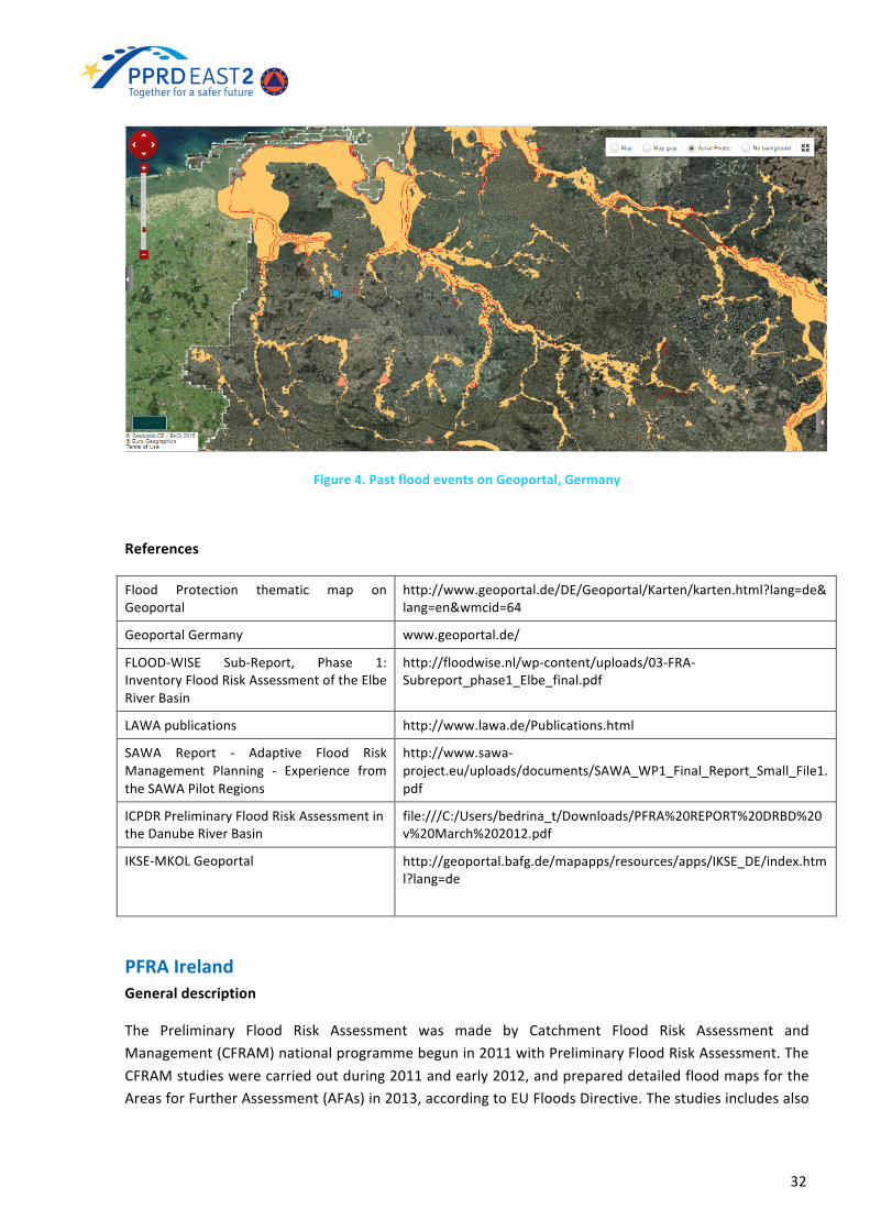
Figure4.PastfloodeventsonGeoportal,Germany
References
Flood Protection thematic map onGeoportal
http://www.geoportal.de/DE/Geoportal/Karten/karten.html?lang=de&lang=en&wmcid=64
GeoportalGermany www.geoportal.de/
FLOOD-WISE Sub-Report, Phase 1:InventoryFloodRiskAssessmentoftheElbeRiverBasin
http://floodwise.nl/wp-content/uploads/03-FRA-Subreport_phase1_Elbe_final.pdf
LAWApublications http://www.lawa.de/Publications.htmlSAWA Report - Adaptive Flood RiskManagement Planning - Experience fromtheSAWAPilotRegions
http://www.sawa-project.eu/uploads/documents/SAWA_WP1_Final_Report_Small_File1.pdf
ICPDRPreliminaryFloodRiskAssessmentintheDanubeRiverBasin
file:///C:/Users/bedrina_t/Downloads/PFRA%20REPORT%20DRBD%20v%20March%202012.pdf
IKSE-MKOLGeoportal http://geoportal.bafg.de/mapapps/resources/apps/IKSE_DE/index.html?lang=de
PFRAIrelandGeneraldescription
The Preliminary Flood Risk Assessment was made by Catchment Flood Risk Assessment andManagement(CFRAM)nationalprogrammebegunin2011withPreliminaryFloodRiskAssessment.TheCFRAMstudieswerecarriedoutduring2011andearly2012,andprepareddetailedfloodmapsfortheAreasforFurtherAssessment(AFAs)in2013,accordingtoEUFloodsDirective.Thestudiesincludesalso

33
developmentofFloodHazardMapping(2014)andFloodRiskManagementPlans(2015)andprovidealong-termstrategyandprioritisedmeasurestoreduceandmanagethefloodrisk.
Methodology
ThreekeyapproacheshavebeenusedinundertakingthePFRAtoidentifytheAFAs:−HistoricFloodRiskAssessment:informationonfloodsthathavehappenedinthepast.
o NaturalSourcesofFloodRisko Floodsfrominfrastructurefailure
− Predictive Analysis is an assessment of areas that could be prone to flooding, as determined bypredictivetechniquessuchasmodelling,analysisorothercalculations,andofthepotentialdamagethatcould be caused by such flooding. The flood risk is a function, or combination, of the hazard andconsequences.TheGiventhelackofavailableinformationonpastfloodextents,andthebroaderneedfor flood maps with a national coverage Office of Public Works (OPW) has determined predictiveassessmentsuitableforIreland.− Consultation: use of local and expert knowledge of the Local Authorities and other Governmentdepartmentsandagenciestoidentifyareaspronetofloodingandthepotentialconsequencesthatcouldarise. Other EU Member States have used similar approaches to undertaking the PFRA as thatundertakeninIreland.The PFRA is not a detailed assessment of flood risk. It is rather a broad-scale assessment ofcommunities,facilitiesandsiteswheretheriskduetofloodingmightpotentiallybesignificant.TheAFAsaresubjectedtomoredetailedassessmentsandanalysisbyCFRAMandparallelstudies.ThePFRAconsidersfloodriskarisingfromanymajorsourceofflooding,including:NaturalSources:
o Rivers(fluvial,includingincreasedflowfromsnowmelt)o Sea(coastalandtidal)o Groundwatero Rainfall(pluvial)o Tsunami(duetoearthquakes,seabedlandslips)
InfrastructuralSources:o UrbanStorm-waterDrainageSystems(dueundercapacity)o Reservoirs(duetobreachofwalls/embankments)o WaterSupplySystems(duetoburstwatermains)o ESBInfrastructure(hydropowerdamsandembankments)o WaterwaysIrelandInfrastructure(embankedcanals).
To determine fluvial flood levels and then flood extents at each major node every 500m andintermediatenodeat 100m spacing, a floodplain cross-sectionwasderived from theOPW’snationalDTM.Thefloodlevelforout-of-bankfloodflowwascalculatedusinghydrauliccalculationandbasedonthecross-section,slopeandresistancetoflow.Floodlevelwasextrapolatedacrossthecrosssectiontoidentify theouterextentsof the floodon thatcrosssection.Theouterextentsof the floodwere thenlinearlyjoineduptocreateamapoftheprojectedfloodextents.Outcomes
TheOPWdatabasecontainsinformationonover5,000pastfloodeventsthroughoutthecountry.OntheNationalCFRAMProgrammewebsiteareprovidedPFRAmapsthatindicate:
− Indicativeareaspotentiallypronetofloodingfromnaturalsourcesoffloodwaterbasedonthepreliminaryanalysis,and,
34
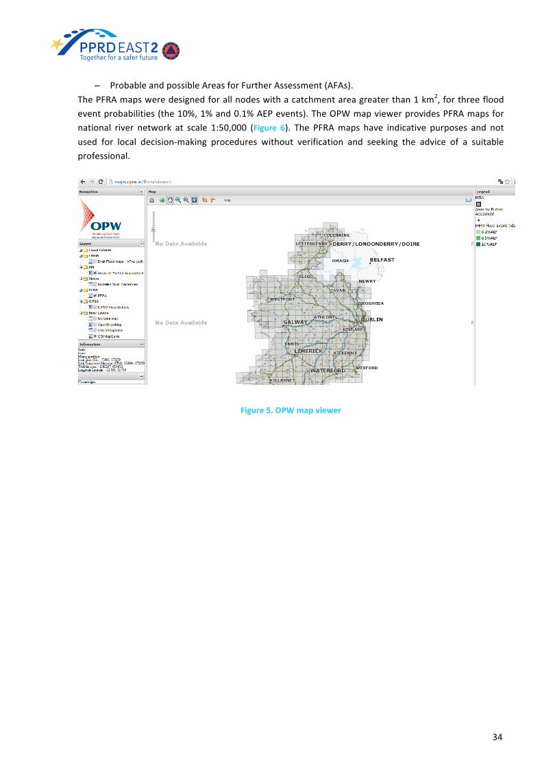
− ProbableandpossibleAreasforFurtherAssessment(AFAs).ThePFRAmapsweredesignedforallnodeswithacatchmentareagreaterthan1km2,forthreefloodeventprobabilities(the10%,1%and0.1%AEPevents).TheOPWmapviewerprovidesPFRAmapsfornational river network at scale 1:50,000 (Figure 6). The PFRAmaps have indicative purposes and notused for local decision-making procedures without verification and seeking the advice of a suitableprofessional.
Figure5.OPWmapviewer

35
Figure6.PreliminaryFloodRiskAssessmentmaps,Ireland
References
Descriptionsofthereportedpastfloodsareprovidedviathenationalfloodhazardmappingwebsite
www.floodmaps.ie
NationalCFRAMProgrammewebsite www.cfram.ieOPWmapsviewer http://maps.opw.ie/fhrm/viewer/ThenationalPFRAReport,March2012 http://www.cfram.ie/wordpress/wp-
content/uploads/2013/06/PFRA-Main-Report.pdf
5.3 PFRACurrent Statusof Preliminary FloodRiskAssessment inPartnerCountries
InTable2ispresentedcurrentstatusofPFRAinEaPcountriesdetectedduringNAGmeetings2015.IngeneralinallpartnercountriesPFRAisdevelopedonlyformainriversfinancedbyinternationalprojects.OnlyGeorgiahasPFRAofentireterritorydevelopedin2011.
EaPcountries PFRAcurrentstatus
Azerbaijan isnotdeveloped;on-goingactivitiesinplace
Armenia initialtentativeduringPPRDEast1hasbeenundertaken
Belarus forthe5biggestbasinshasbeencarried;refineddataforsome
36
projects
Georgia areavailableatnationallevelfrom2011.Needtobeupdated
Moldova coversonlythemainriversnetworkandthereisnoclearcriterionfortheselectionoftherisk-proneareas
Ukraine ismostlytakencoveredbymeansofpilotprojects
Table2.CurrentstatusofPFRAinEaPcountries
In Table 3 are listed recommendations provided during NAG meetings to EaP countries. Somerecommendationsarethesameforpartnercountries,someofthemaredevelopedconsideringnationalfeaturesofinstitutionalstructureandcurrentstatusofPFRA.
EaPcountries
training/capacitybuilding
programmefortheinstitutionalstakeholders
developacommonsetofmethodologiesandtechniquesaccordingto
EUFDArticles4–6
Additional
Azerbaijan V V Startfromapilotbasin.ThemethodologydevelopedduringPPRDEast1shouldbeusedasastartingpoint
Armenia V - -
Belarus V - Itisrecommendedtoextendthedetailanalysistotherestofthecountry
Georgia - V UpdatingandenhancingthecurrentPFRAstartingfromtheKurariverbasinasaPilot
Moldova V V StartfromwhathasbeenalreadydevelopedbyMoE
Ukraine - V Surveyandmapsdrafting
Table3.SummaryofrecommendationsforPFRAdevelopmentinEaPcountries
ARMENIA
During PPRD East Phase 1, Institute of Geological Sciences - ArmenianNational Academy of Sciences(NAS IGS) was in charge for computing flood hazard and flood risk maps. A sort of preliminary riskassessment has been undertaken by analysing the MTAES database on floods. By doing that, muchinformationabout theeventhasbeendigitalized;nevertheless this analysisdidnot lead todefinitionandmappingofareasofpotentiallysignificantfloodrisk(APSFR).
AZERBAIJAN
PreliminaryFloodRiskAssessmentisnotdevelopedinAzerbaijan,howeverthereareon-goingactivitiesthatarerelatedwiththerequirementofEUFDonPreliminaryFloodRiskAssessment:collectionofhistoricaldataonfloods(MES),identificationoffloodproneareas,identificationofelementatrisk(MES),floodRiskmapsofPPRDEast1.ThoseactionssurelyrepresentastartingpointforthefullimplementationoftheEUFD.

37
BELARUS
PFRA in line with EUFD has been carried for the 5 biggest basins on the basis of historical floodsdatabaseandAPSFRsareavailableatdistrictandbasinscale.MorerefineddatahavebeencomputedduringpilotprojectsonlyforWesternBug,Iputriver(UpperDnieperbasin)andpartofthePripyat.GEORGIA
PFRAareavailableontheentireGeorgianterritoryalthoughtheyneedtobeupdatedastheyarebasedonastudymainlydevelopedin2011.HowevertheyrepresentavalidstartforthecompliancewiththeEUFD requirements. The various international initiatives include development of PFRA component asoneofthebuildingblock.MOLDOVA
PFRAhasbeenconductedbyBetaStudioandHRWallingfordfortheentireMoldavianterritoryunderthe Programme “Management and Technical Assistance Support toMoldova Flood Protection”.MoE,withthefinancialsupportoftheEuropeanInvestmentBank,isimplementingthisProgramme.AspartoftheProgramme,thetechnicalassistancehasbeentenderedwiththeaimofpreparingPreliminaryFloodRiskAssessmentforMoldova.However,PFRAcoversonlythemainriversnetworkandthere isnoclearcriterionfortheselectionoftherisk-proneareas.
UKRAINE
PFRAismostlytakencoveredbymeansofpilotprojects.Thoseactionssurelyrepresentastartingpointfor the full implementation of the EUFD but, nevertheless, inevitably provide a fragmented coveragewithpotentialsubstantialmethodologicaldifferences.Inadditionleavingsuchanimportanttopicunderthesole impulseof international support instruments,whicharehighly fluctuant,doesn’tprovide theprogrammaticstabilityrequiredtodevelopasoundroadmapforacomplextopicsuchastheEUFD.
5.4 GuidanceandMethodologiesforPreliminaryFloodRiskAssessment
Implementing the EUFD is made possible through the establishment of more or less detailed dataarchives connected to all the information sources that are relevant to the fulfillment ofmore or lessdetailedstudiesfortheapproximationofeachstepprovidedforbyDirective.
DataManagement
For this reason all aspects in finding the information, analyze it, process it to produce themaps andpublishtheresults inthemannerprescribedbyEUFD,shouldbethesubjectofacriticalplanningandtargetedtocreateaneffectivesubsetwhoseelaborationwillidentifythefloodriskareasandwhateverconnectedatleastwithapproximatemethods,orifpossiblewithmoredetailedstudies.
Inpresentingthegeneralframeworkofstudiestobedescribedinthefollowingchapters,itisusefultoconsiderthattherearesomecommonpointsinthevariousarticlesoftheEUFD.Ingeneralitisneededtoperformstudiesthatarisewiththecollectionoffloodeventsinthepasttogettopredictivemapping,andcalculationsstartfromconsiderationsevenverysimplifiedtoarrivetodetaileddescriptionswiththe

38
evolutionofthestudies.ItstartsfromtheidentificationofAreasofPotentialSignificantFloodRisk,thatarethespatialobjectsonwhichallsubsequentstudiesareimplanted.Theseelementsinthetruthcanbe representedwithdifferentgeometry types: criticalpoints, in the caseofmethodsof identificationbasedonlyon the simple localizationof coordinatesofpreviousevents; areaswithadominant lineardistribution, where the studies are linked to critical sections of waterways; areas with variabledistribution,inthecasetheanalysesarebasedonadministrativeunitsorcomparedtoareasofvariableamplitudearoundthesitesofpastevents.
However, on these critical and strategic areas, it is necessary to provide the construction ofmultiplehazardandriskscenarios,eachcharacterizedbyspecificconsequences thatcannotbeseparatedbyascreening of the possible receptors of risk. The criteria for differentiation of risk receptors must bebrought back to the classesHuman health, Environment, Cultural heritage, Economic activity, or in amore conciseway, Social, Environmental, Cultural, Economical Themethods for assigningaweight tothese receptors and assigning a value to their physical and possibly systemic vulnerabilities arecharacteristicofeachareaandawell-structuredapproachtothestudycannotignoretheneedofmanypassagesofmodelingandback-analysisaimed to identify themostappropriatevalues for the systemyouareanalyzing.Theabsenceofthesecriticalfiltersmayoccurinextremecasesinwhich,startingfromhistorical events of the past, the whole territory remains affected under investigation for theconstruction of future risk scenarios and all the affected areas have the same value for planningpurposes,oronthecontrary,onlyaverysmallportionofthecountryistakenintoaccount.
So,indraftingageneralschemeforthecollectionofdatanecessarytotheimplementationofEUFD,ithastobeconsideredthat,beyondthehistoricinformationonpastfloodevents,whateverusefultothedescription of the territory and of the Social, Economic, Environmental, Cultural receptors could beused.Atleastacoredatasetofminimumgeospatialelementsisneeded:
• adescriptionoftherivernetwork
• adescriptionofthelanduse
• thedistributionofpopulation
This is an oversimplification, and certainly it is advisable, if possible, to have other additionalinformation on population, objects of significance, areas and activities that could suffer harm in theeventofafloods.
In this case it ispossible todefine the so-called IndividualReceptors18 (e.g.Hospitals,PowerStations,Airports,Schools),ArealReceptors(e.g.Cities,Villages,EnvironmentalSites),Social Infrastructure(e.g.Emergency Response Centres, Evacuation Centres), Critical Utilities (e.g. Water Supply & Treatment,Electricity,Communications)orevenspecificclassesofpopulation(e.gVulnerablePeople-Elderly,VeryYoung)
Considering the needs for a proper application of models, of extreme importance are also: DigitalElevationModels (DEM), topographicmaps,hydrologicaldata,hydraulic structuresandmapsof floodextentofthepast.
A specific attention should be paid to the scale of data and their compliancy with the scale of thestudies;moreover, itmust be checked for topological correctness and compliancy with internationalstandards.Aboutthispoint,theEUFDrecommendstheassessmentofpotentialriskbasedonavailable
18(TheEU‘Floods’Directive,MarkAdamson(2011)atlinkhttps://www.msb.se/Upload/Utbildning_och_ovning/Ovning/Barents_rescue/2011/Documentation/The%20EU%20floods%20directive.pdf)
39
orreadilyderivableinformation.Moreover, inthecaseof internationalriverbasindistricts,orunitsofmanagement which are shared with other Member States, Member States have to ensure thatexchangeofrelevantinformationtakesplacebetweenthecompetentauthoritiesconcerned.Thismeansthatdatahavetobeproducedandsharedusingstandardproceduresandclassifications.TheGuidance19 forReportingunder the “Directive2007/60/ECof theEuropeanParliamentandof theCouncilof23October2007ontheassessmentandmanagementoffloodrisks”(FloodsDirective)aimsatproviding background information on reporting requirements according to the EUFD, supporting EUMemberStates inthestructuredpreparationof informationanddatatobereportedtotheEuropeanCommission and giving explanations on how the European Commission intends to use the data forcompliance assessment and drafting reports regarding the overall implementation of the FloodsDirectiveinEU27MemberStates.
Reporting of floods related data and information through theWater Information System for EuropeshouldensureconsistencyandadequateinformationflowswithotherEUwaterlegislation,notablytheWaterFrameworkDirective2000/60/EC,theDrinkingWaterDirective98/83/ECandtheBathingWaterDirective2006/7/ECand should achieve compliancewith theobligationsunder the INSPIREDirective.Please refer users of this report to the specific reading of the documentmentioned above for an in-depth analysis of the use of data and information to check compliance and to ensure a consistentimplementationoftheEUFDthroughouttheEUaswellastheuseofdatathroughotherpotentialusers.
BasicDatacollectionPFRAPhase1
ForthefirstphaseofthePFRAthefollowingbasicdatashouldbeused:
1. CORINElandcovermaps2. Populationdensitymaps-quantitativeinformationaboutpopulation3. Rivernetwork4. Historicallyfloodedareas/floodableareasmaps5. Othergeospatialdataaboutexposure
Afirstsurveyshouldbedoneinordertodefine:availabilityofdata,dataowners,spatialcoverage(local,regionalornational)anditsresolution,format(e.g.GISmaps,simplePDF,papermaps).Asanexample,the maps production of historically flooded areas could take advantage from archivedlocal/crowdsoucinginformationonpastevents.
InordertoproceedwithPFRAevaluationitisrecommendedtoadoptatleastareferencegridasshowninTable1.
DATA availability owner/distributor extent/resolution format
CORINELandCover
Populationdensitymapsorsimilar
Rivernetwork
19 (Guidance for Reporting under the Floods Directive 2007/60/EC (2013-071) at linkhttps://circabc.europa.eu/sd/a/acbcd98a-9540-480e-a876-420b7de64eba/Floods%20Reporting%20guidance%20-%20final_with%20revised%20paragraph%204.2.3.pdf)

40
Historicallyfloodedareas/floodableareasmaps
Othergeospatialdataaboutexposure
Table4.ReferencetableforPFRAsurveyonavailabilityandaccessibilityofbasicdata
At theendof the survey, aproperplan strongly linkedwith the capacitybuildingactivities shouldbedefined,andalldatashouldbemadeavailableinacommondigitalGISformat.The informationcollectedduringthesurveycouldalsoconsiderandreportaboutthekindof floodingprocessrelatedtoeachfloodevent.ThedetailsofthedifferenttypeoffloodsthatarerelevantineachareaismandatoryinthesecondstepoftheEUFD(FloodHazardandRiskMapping)reportedinthenextchapter.
Preliminaryfloodhazardandriskmaps–PFRAPhase2
Once the Phase 1 has been completed, the operational process should move from the preliminaryevaluationofthefloodhazardtoapreliminaryfloodriskevaluation.ThisshouldbedonebycombiningthebasicdataobtainedinPhase1toproduce:
• Preliminaryfloodhazards(from:Historicalfloods/floodableareas+spatialbuffer);• Preliminary flood risk (from: Preliminary flood hazards + Population density maps + Other
geospatialdataaboutexposure);
Figure7.PreliminaryFloodRiskAssessment
PreliminaryFloodHazardoperationalexampleForthepreliminaryfloodhazardevaluation,thefollowingtypesoffloodscanbeconsidered:Fluvialfloods,Flashfloods,Floodingduetoovertoppingandstructuralfailures,Seafloods/stormsurges(ifapplicable),Failuresofhighdams.

41
At this stage a simplified methodology should be used in order to define the method (or thecombination of methods) for flood prone areas identification with the aim to enable theclassificationandprioritizationofareasconsideringtheadverseconsequencesofflooding.Thesemethodsinclude:A. Geological approach, based on geological maps. In this hydro-geomorphological mapping
method river beds are studied using topographic information (orthophotos, Digital ElevationModel-DEM)andgeologicalinformation.
B. GISapproaches,wereportinthefollowingtwoexamples:• "Waterlevelrise"methodthatisbasedontheprincipleofrisingthewaterlevelintheriverbed.
Theaccuracyoftheresultsofthismethoddependsonthequalityofexistingdigitalelevationmaps
• Another example is represented by the EXZECO (un code d’EXctraction des Zonesd’ECOulement)Method20 (developed inFrance)that isbasedon increasingthe levelofriverbasinwater. Themethod runswith the existing digital elevationmap. The accuracy of themaphasasignificanteffectonthequalityoftheresults.TheoutputsofEXZECOmethodwasappliedforTurkeyonlytomakecomparisonwithothermethodsanddidnotrecommendtousethismethodinareaswhichhavelesssteepslopes.
C. Simplifiedmodelingmethods.
PreliminaryFloodRiskoperationalexample
ThemapsofthepreliminaryriskreceptorsshouldberankorderedandcombinedinordertoobtainthePreliminary risk levelsmaps. The following elements could be considered flood risk receptors. ThesereceptorsareafirstsuggestionandrepresentabaselineversionofthereceptorsinthePFRAphase:
• Settlements• Industries• Road,railways,transportlines• Significantinfrastructures• Agriculture• Forests,landfieldsandingeneralnot-populatedareas.
AfinalmapdefiningtheareasofPreliminaryFloodRiskwillthenbeprepared.
Theoperationalprocessassignsriskindicatorstoflood-proneareasbyoverlappingthemwiththelandusemaps that report, in a simplified way, the risk receptors considered. As an example, one usefuldatasettoevaluatetheelementsexposedtofloodsisthelandusereportedintheCORINELandCover(CLC)mapsandrepresentingeconomicandhumanlosses.
Theflood-proneareasidentifiedinthepreliminaryfloodhazardassessmentshouldbecombinedwithasignificant selection of risk receptors under potential future flood areas such as data survey readilyavailableinaGISformatforeachunitofmanagement.In Table 4 is given data survey of geospatial layers for the implementation of preliminary flood riskassessment studies or flood hazard and risk maps. It contains detailed list of assets and objects of
20 http://www.jspacesystems.or.jp/ersdac/GDEM/E/4.html (data GeoTIFF format with geographic lat/longcoordinatesanda1arcsecond-approximately30mgrid);
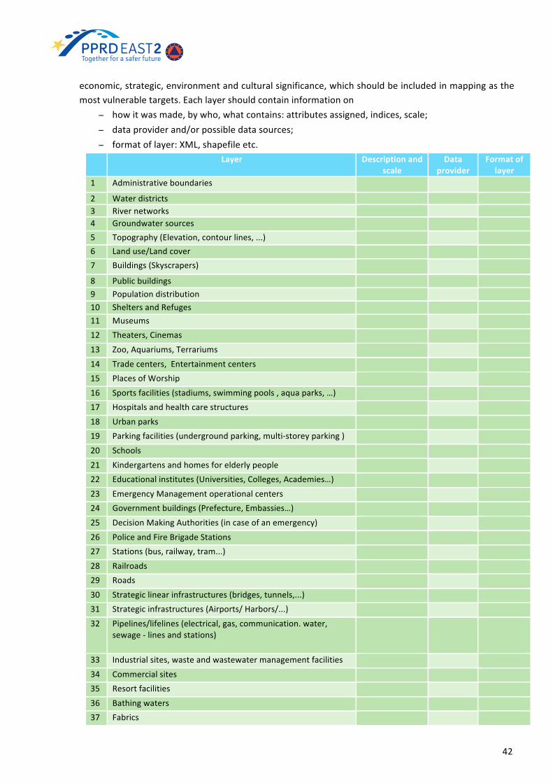
42
economic,strategic,environmentandculturalsignificance,whichshouldbeincludedinmappingasthemostvulnerabletargets.Eachlayershouldcontaininformationon
− howitwasmade,bywho,whatcontains:attributesassigned,indices,scale;− dataproviderand/orpossibledatasources;− formatoflayer:XML,shapefileetc. Layer Descriptionand
scaleData
providerFormatof
layer1 Administrativeboundaries
2 Waterdistricts 3 Rivernetworks 4 Groundwatersources 5 Topography(Elevation,contourlines,...) 6 Landuse/Landcover 7 Buildings(Skyscrapers)
8 Publicbuildings 9 Populationdistribution 10 SheltersandRefuges 11 Museums 12 Theaters,Cinemas
13 Zoo,Aquariums,Terrariums
14 Tradecenters,Entertainmentcenters 15 PlacesofWorship
16 Sportsfacilities(stadiums,swimmingpools,aquaparks,…) 17 Hospitalsandhealthcarestructures
18 Urbanparks 19 Parkingfacilities(undergroundparking,multi-storeyparking)
20 Schools
21 Kindergartensandhomesforelderlypeople 22 Educationalinstitutes(Universities,Colleges,Academies…)
23 EmergencyManagementoperationalcenters 24 Governmentbuildings(Prefecture,Embassies…)
25 DecisionMakingAuthorities(incaseofanemergency)
26 PoliceandFireBrigadeStations 27 Stations(bus,railway,tram...)
28 Railroads 29 Roads
30 Strategiclinearinfrastructures(bridges,tunnels,...) 31 Strategicinfrastructures(Airports/Harbors/...)
32 Pipelines/lifelines(electrical,gas,communication.water,sewage-linesandstations)
33 Industrialsites,wasteandwastewatermanagementfacilities
34 Commercialsites 35 Resortfacilities
36 Bathingwaters 37 Fabrics

43
Inthiswayit ispossibletoevaluatethePreliminaryFloodRiskAreasintermsofsimpleadministrativeunits(e.g.municipalities).Asanexample,foreachadministrativeunit,shouldbeidentifiedthenumber(andpossiblytheposition)oftheareasatriskofflood.Theindicatorsoneachadministrativeunit,givenforthepurposesofdecisionmakers,allowobjectivecomparisonandhelptodefineAPSFRbysub-riverbasin,riversegments,byadministrativeboundaries.
AreasofPotentialSignificantFloodRisk
Once the PFRA are identified, the Areas of Potential Significant Flood Risk can be defined by usingthreshold values on the indicators related to the assessment of preliminary flood risk. The thresholdvaluesusedforselectingAPSFRaredeterminedbyindicatorssuchas:
Indicator ThresholdValueUrban residential areas at risk offlood >2km2
Economicactivityareasatfloodrisk >1km2
PPRDEast1recommendationsinPFRAestablishment
The PPRD East1 Risk/Hazard Assessment Policy21 EUFD provides some important details on PFRAprocess.ItisisbasicallycompliantwithEUFDguidance.Accordingtothisguidelines,theriskassessmentprocessshouldbeundertakenthroughthedevelopmentofanumberofdifferentmethods.
Riskisdefinedas:
Risk=HazardxVulnerabilityxExposure
TheRiskMatrixapproachwasproposedbyPPRDEast1AssessmentPolicyatnationalleveltoassistriskidentification. The Risk Matrix approach can define a recordable disaster while also developing anunderstanding of where additional analysis is required. The identification of risks is proposed to
21(PPRDEast1Risk/HazardAssessmentPolicyfortheENPIEasternRegion(2012)atlinkhttp://euroeastcp.eu/assets/files/Publications/Risk%20Hazard%20Assessment%20Policy_en.pdf)
38 Industrialfacilities 39 Farms,grazingareas
40 Plantations,agriculturalfields
41 Protectedareasandparks 42 UNESCOculturalheritage
43 Gaugingstations,Meteorological,Hydrologicalstations 44 Hydraulicstructures(dams,dykes,..)
45 Historicalfloodsandpastfloodmaps 46 FloodHazardmaps
47 FloodRiskmaps
Table5.Datasurveyofgeospatiallayers

44
undertakeinastep-wiseapproachconsistingoffourcomponents,accordingto“ECRiskAssessmentandMappingGuidelinesforDisasterManagement”22(2010):
a) scenariobuilding;b) extentofquantitativeanalysis(theextentofhazardthatdeterminesarisk);c) numberofriskandriskscenariosconsidered(amountdeemedasrequiringattention);d) andtemporalhorizons(likelyreturnperiodintheshortterm).
Threekeyelementsweredefinedforidentifyingahazard:-location(coordinates/area);-probabilityofoccurrence;and-intensity.Consistent recording of hazards throughout the identification phase was recognized as essential toensure separate hazard. Probability of occurrence can be considered as a percentage of a probablereturnperiodoverasetlengthoftime.Intensityotherwiseknownasimpactscanbecharacterizedinanumberofdifferentofways,theseincludebutarenotrestrictedto:
− Cost–relatingtotheacceptablefinancialimpactfromadisasterinUSD;− Casualties–relatedtothetotalnumberofverysignificantinjuriesorhumandeathsasaresult
of a disaster may include: Effected people – relates to number of people reported as beinginjuredandillrequiringhospitalassistance;Displacedpeople–relatestothenumberofpeopledisplacedfromtheirhomesasaresultofadisaster;
− Environmentalimpact.
RiskIdentification
ByPPRDEAST1Risk/HazardAssessmentPolicy is proposed theuseof the riskmatrix during the riskidentificationstageforfurtherdevelopingofunderstandingoftherisksandtheimpacttheypresentataregional and national level. The use of the risk matrix tool also allows comparison of different risksituations quantitatively by considering the various ensuring consistency to assessing the impact andprobabilityofanevent.Whereadditional risk investigationsmeasureshavebeen identified through the riskmatrix approach,specific hazard, vulnerability and exposure analysis can be undertaken. These methods are alsodocumentwithintheriskanalysissectionofthispolicy.Attheriskidentificationstageitisimportanttoconsider all hazards, how they interact, their probability of occurrence and their possible impact.Analysis on this scale is referred to as considering “risk scenarios”. Risk scenarios are a plausibledescriptionofhowthefuturemaydevelop.Scenariobuildingismainlybasedonexperiencefrompastevents, risk matrixes can be used to develop the scenarios when considering the different plausibleoutcomes.
PPRDEAST1RiskMatrixHazardAnalysis
Theriskmatrixisavisualizationtoolthatrelatesthetwodimensionsofadisaster,notablylikelihoodandimpact.Theyarerepresentedinagraphicalformattofacilitatethequantitativecomparisonofdifferentrisks.Withineachcategorybothimpactandlikelihoodtherelativeimportanceshouldbegradedusingaqualitative process of considering the impact from previous disasters, acceptable impact levels andinformationfromkeyexperts.Asinglesetofcriteriatoscoretherelativelikelihoodsandimpactstothedifferent hazard risk scenarios originally identified is required to be set, this criterion must beconsideredconsistentlyacrossallthedifferenthazardsthatarebeingassessed.
22(ECRiskAssessmentandMappingGuidelinesforDisasterManagement(2010)atlinkhttps://ec.europa.eu/echo/files/about/COMM_PDF_SEC_2010_1626_F_staff_working_document_en.pdf)
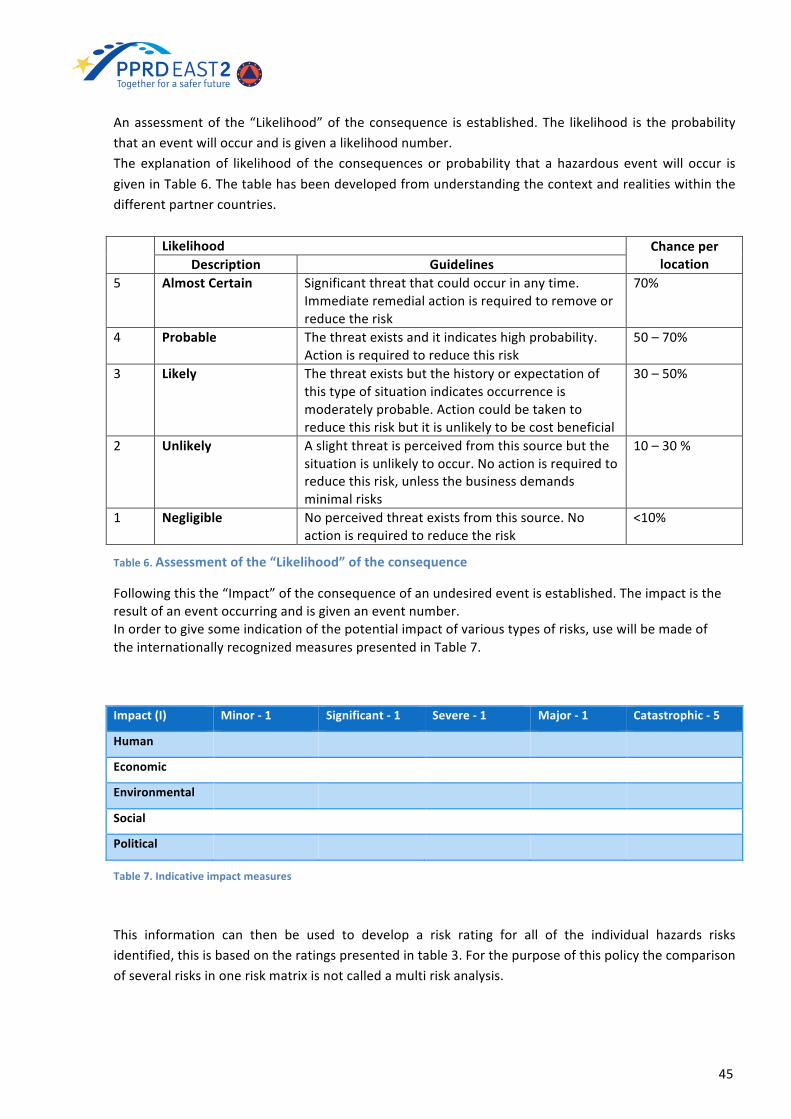
45
Anassessmentof the“Likelihood”of theconsequence isestablished.The likelihood is theprobabilitythataneventwilloccurandisgivenalikelihoodnumber.The explanationof likelihoodof the consequences or probability that a hazardous eventwill occur isgiveninTable6.Thetablehasbeendevelopedfromunderstandingthecontextandrealitieswithinthedifferentpartnercountries.
Likelihood ChanceperlocationDescription Guidelines
5 AlmostCertain Significantthreatthatcouldoccurinanytime.Immediateremedialactionisrequiredtoremoveorreducetherisk
70%
4 Probable Thethreatexistsanditindicateshighprobability.Actionisrequiredtoreducethisrisk
50–70%
3 Likely Thethreatexistsbutthehistoryorexpectationofthistypeofsituationindicatesoccurrenceismoderatelyprobable.Actioncouldbetakentoreducethisriskbutitisunlikelytobecostbeneficial
30–50%
2 Unlikely Aslightthreatisperceivedfromthissourcebutthesituationisunlikelytooccur.Noactionisrequiredtoreducethisrisk,unlessthebusinessdemandsminimalrisks
10–30%
1 Negligible Noperceivedthreatexistsfromthissource.Noactionisrequiredtoreducetherisk
<10%
Table6.Assessmentofthe“Likelihood”oftheconsequence
Followingthisthe“Impact”oftheconsequenceofanundesiredeventisestablished.Theimpactistheresultofaneventoccurringandisgivenaneventnumber.Inordertogivesomeindicationofthepotentialimpactofvarioustypesofrisks,usewillbemadeoftheinternationallyrecognizedmeasurespresentedinTable7.
Impact(I) Minor-1 Significant-1 Severe-1 Major-1 Catastrophic-5
Human
Economic
Environmental
Social
Political
Table7.Indicativeimpactmeasures
This information can then be used to develop a risk rating for all of the individual hazards risksidentified,thisisbasedontheratingspresentedintable3.Forthepurposeofthispolicythecomparisonofseveralrisksinoneriskmatrixisnotcalledamultiriskanalysis.

46
Relativelikelihood
Relative
HazardImpact
1.Negligible 2.Unlikely 3.Likely 4.Probable 5.Almost
certain
5.Catastrophic Medium High VeryHigh VeryHigh VeryHigh
4.Major Medium High VeryHigh VeryHigh VeryHigh
3.Severe Medium High High High High
2.Significant Low Medium Medium Medium Medium
1.Minor Low Low Low Low Low
Table8.Riskratings
47
6. FloodHazardandRiskAssessment
ThissectionprovidesfloodhazardmapsandfloodriskmapsexplanationintheframeworkofEUFD.TheFloodHazardMapsandFloodRiskMaps (FHRM)generaloperationalscheme ispresented. ItcontainsgeneralinformationonpreparatorystagesforFHRMproducing:
− Typeoffloodstobeconsidered− Typeofinformationneededforthehazard/riskmaps− Kindofhazardandriskmapsproduced
Thedatacollection,FHMandFRMdefinitionandproductionprocedurearebrieflydescribed.Themethodology used by EUMember States and a short overview on development of FHRMby EUMember States is given on the base of the report of European Commission “EU overview ofmethodologiesusedinpreparationofFloodHazardandFloodRiskMaps”23(2015).ThecurrentstatusinEaP countries of PPRD East2 project is described in this section. The main recommendations ondevelopmentofFHRMforeachcountrytakentakenfromCountryProfilesof2015arepresented.
6.1 TheScopeofFloodHazardandRiskAssessment
AccordingtoFloodsDirectiveEUMemberStatesshouldpreparefloodhazardmapsandfloodriskmaps(Article6)at themostappropriatescale for theareas identifiedunderArticle5.1 (APSFR), taking intoaccountalsoexchangeofinformationbetweentheCountriesincaseofinternationalbasins.Floodhazardmapsshallcoverthegeographicalareaswhichcouldbefloodedaccordingtothescenariosof: lowprobability,orextremeeventscenarios;mediumprobability (likelyreturnperiod≥100years);highprobability,whereappropriate.Incaseofcoastalareaswhereanadequatelevelofprotectionisinplace,orforareaswhereflooding isfromgroundwatersources,thepreparationoffloodhazardmapscanbelimitedtolowprobabilityscenarios.Flood risk maps shall show the potential adverse consequences in terms of inhabitants potentiallyaffected,economicactivitiespotentiallyaffected,environmentalissuesandotherinformation.OncethePreliminaryFloodRiskAssessment(PFRA)hasbeenperformed,thesecondphasewouldbetoset-upthedefinitionofFloodHazardMaps(FRM)andFloodRiskMaps(FRM).Theobjectiveofthisphasecanbelookedatfromdifferentpointsofviewdependingonthestakeholderconsidered.TheproductionofFHMandFRMhasdifferentaspects:
• technical• organizational• political
AsforthePFRAalsointhisphaseshouldbedefinedtheinstitutions(Figure4)that:1. areinchargeofcoordinatingtheFloodHazardandFloodRiskmapping,
23(EUoverviewofmethodologiesFHRM(2015)atlinkhttp://ec.europa.eu/environment/water/flood_risk/pdf/fhrm_reports/EU%20FHRM%20Overview%20Report.pdf)

48
2. havethebasictechnicalknowledgeofmanagingtheFloodHazardandFloodRiskmappingdataeventually available, have the information at local/catchment level in accordance with therequirementsoftheFloodHazardandFloodRiskmapping.
6.2 Overviewof FloodHazardandRiskAssessment inEUMemberStates
After definition of involved institutions in Flood Hazard and Risk Assessment the OperationalProcedureon Flood Hazard and Risk Maps development is launched. The Operational Scheme isprovidedbelow..
OPERATIONALSCHEMEofFloodHazardMapsandFloodRiskMaps
ProductionofFloodHazardandMapsFloodRiskMapsatNationallevel,usingcommoncriteria.Aspectsthatshoulddrivetheoperationalprocedure:
1. Type of floods to be considered - Floods can have various origins depending on thecharacteristicsofthebasinsandmeteorologicalregime.Adecisionhastobetakenwhichtypesoffloodsshouldbeconsidered.Theoriginoffloodscanbeverydifferent,e.g.floodingfromthesea, flashfloods,groundwaterflooding.Considerwhetherfloodingfromtheseamightcreateserious risks and if so, checkwhether collected data are sufficient. The same holds for areaswhereflashfloodsorfloodsfromgroundwateroccurinamorethanaccidentalway.
2. Typeofinformationneededforthehazard/riskmaps–ThischoicedependsontheoperationaluseofFHMandFRM.ExampleofinformationneededinthefullcycleofDisasterManagement:prevention/mitigation,preparedness,responseandrecovery
• Institutions involved in the prevention and preparedness phase (e.g. in production orapplicationofspatialplans).Inthiscaseitisimportant,betweenothers,toknow:
- areasthatcanbefloodedand- waterdepththatcanbereachedwithitsassociateditsreturnperiod,whilefor
• Institutions involved in early warning, crisis management plans and emergencymanagement(responseandrecovery)itisimportanttoknow:
Figure8.Involvedinstitutions.

49
- areasthatcanbeflooded,- scenarios(in terms of planning) and possible reliable estimate (during flood
events)about:§ peopleinvolved,§ possibledamages,§ mostsensitiveareas,§ mosteffectiveevacuationstrategy.
3. Kindofhazardandriskmapsproduced-Onthebasisofwhatreportedabove,foreachscenario(highprobability,mediumprobabilityandlowprobability)Thehazardmapsshouldinclude:
a. Inundatedareab. Maximumwaterdepthc. Flowvelocity(ifitisrelevant)
Theriskmapsshouldinclude(atleast):
a. Numberofpeoplelivinginthepotentialinundatedareasb. Economicactivitiesinthepotentialinundatedareasc. Industries/Installationssubjecttorelevantriskinthepotentialinundatedareas.
Consider the transboundary basins in order to proper manage a coordinated and homogeneousapproachinpreparingtheFHMandFRM.
Datacollection
The development of flood hazard maps and flood risk maps requires a large number of data andinformationinordertoproducefloodhazardmapsandfloodriskmaps.The time needed to produce themaps depends not only on what is available but also on how it isavailableandonthequalityofit.Inordertosimplifyandshortentheprocessofdatacollectionafirstsurveyshouldbedoneinordertogetanoverviewofthedataintermsofavailability,qualityandhomogeneity.Beforetheproperproductionofthehazardmaps,anumberofgeneraldecisionsaboutstandardsandworkingmethodshavetobemade:
• Methodology/standards for hazard data production including the definition of the data to beusedforhazardmappingfordifferenttypesoffloods(dataformatandstructure),theprocessofdatacollection,datasubmission,dataupdateandstorageandthemetadatatobeprovided.
• Technical document describing the risk data to be used, the process of data collection andupdate(includingthedescriptionofdataformat,structureandmetadata)
• Technicaldocumentdescribingthefinaldatastructureofhazardandriskdataandtheupdateprocess
FloodHazardMapsdefinitionandproduction
FloodHazardMapsshallcoverthegeographicalareaswhichcouldbefloodedaccordingtothefollowingscenarios:
• Floodswithalowprobability,orextremeeventscenarios;• Floodswithamediumprobability(likelyreturnperiod≥100years);• Floodswithahighprobability,whereappropriate.

50
Thefollowingelementsshallbeshown:• Thefloodextent;• Waterdepthsorwaterlevel,asappropriate;• Whereappropriate,theflowvelocityortherelevantwaterflow.
Forafirststepisrecommendedtofacethefluvialfloodinghazardandtomakeuseof:• ahydrologicalmodeltoproperlyassesstheroutingofprecipitationfromrainfalltorunoff.• ahydraulicmodeltoevaluatedindetailthespatialextensionsoffloodableareas.
Usingthischainitwillbepossibletomodelthefloodextent,waterdepthandflowvelocityfordifferentscenarios.ThetechnicalaspectshowtobuildhydrologicalmodelsfortheproductionofFloodHazardMapswillbepresentedanddetailedduringtheCapacityBuildingsactivities.Duringthemodellingphasethefollowingdatahavetobecollected:
• Topographicmaps• Hydrologicaldata
• Gaugingstation(discharge,waterlevels)• Precipitationdata• Recordedfloodextent
• Geometricaldata• Crosssections• Longitudinalprofile• DigitalTerrainModel(DTM)• Hydraulicstructures(dykes,weirswithoperationalrules,sills,….)
• Hydrographicaldata(watercoursenetwork,gaugingstationlocations,lateralinflows)• Floodextentoffloodsinthepast(fromPFRA)
TheaccuracyofboththemodelsandthehazardmapscanbeimprovedwithabetterDTM.Whendischargeandwaterdepthdataareavailable,avalidationphaseof the results shouldbedonewithlocalpeopletoseewhethertheresultsofmodellingcanbereliableornot.Satelliteimagesoraerialphotographsofpasteventscanusefullysupportthevalidationphase.
FloodRiskMapsdefinitionandproduction
FloodRiskMapswill be developedon the basis of the FHM for the same scenarios. Thesemapswillshow the potential adverse consequences associated to flood scenarios andwill be expressed in thefollowingterms:
• theindicativenumberofinhabitantspotentiallyaffected• typeofeconomicactivityoftheareapotentiallyaffected• otherinformationwhichcanbeconsidersusefulforaproperdefinitionofrisk.
Theinformationcollectedshouldconsidertheriskreceptors.Thedefinitionofriskreceptorsismainlyapoliticaldecisionandadiscussionphasewithpoliticallevelshouldbemade.Oncethereisanagreementoftheriskreceptors,thecollectionofdatacanstart.Theprocedureshoulddefineriskdatatobeused(includingthedescriptionofdataformat,structureandmetadata),theprocessofdatacollectionanditsupdate.
51
ThemethodologyusedbyEUMemberStates
The report of European Commission “EU overview of methodologies used in preparation of FloodHazardandFloodRiskMaps”24(2015)providesasummaryinformationofFHRMinEUMemberStates.
Sourcesoffloods
According to the report “The most commonly mapped source is fluvial flooding with 25 of the 27MemberStatesreportinginformationpreparingsuchmaps.ThetwoMemberStates(LuxembourgandMalta) that did not preparemaps for fluvial sources preparedmaps (only) for pluvial flooding.1 FourotherMember States also prepared specificmaps of pluvial flooding and eight otherMember Statescombinedpluvialfloodingwithotherrelevantsources(usuallyfluvial)intheirmaps.Seventeenofthe22Member Stateswith a coastline (that had reported), preparedmaps of seawater flooding.Only twoMemberStatespreparedmaps forgroundwater floodsandsix for floods fromartificialwaterbearinginfrastructure.
Floodsscenarios
All25MemberStates thathadpreparedand reportedmediumprobability fluvial floods (LuxembourgandMaltaonlymappedpluvialfloods2andBulgariahadnotyetreported)useda100yearreturnperiod(assuggestedbytheDirective)or1%annualexceedanceprobabilityfortheexpressionoftheprobabilityof flooding: somealsousedother returnperiodssuchas200or300years.MostMemberStates thatpreparedandreportedseawaterfloodingmapsalsouseda100yearreturnperiodor1%probabilityfortheexpressionofamediumprobabilityscenario:Irelandusedanannualexceedanceprobabilityof0.5%andItalyeither50or200yearreturnperiodaswellas100years.
Hazardelements
Mostofthe25MemberStatesthathavepreparedfluvialfloodinghazardmapsshowfloodextentsandwater depths/levels for all three probability scenarios. The exceptions are Latvia where the publiclyaccessiblemapsonlyshowfloodextentandDenmarkwherethefloodingprobabilityscenariosarenotshownon themaps. TwelveMember States alsomapped flow velocity or relevantwater flow for allthreeprobabilityscenarios.Thirteenofthe17MemberStatespreparingseawaterfloodmapsproducedhazard maps covering the two required probability scenarios and included the two required hazardelements.WaterdepthandfloodextentwerevisualisedontheDanishhazardmapsbutnotinrelationto any specific scenario. FiveMember States alsomapped flow velocity or relevantwater flow for atleastoneofthethreeprobabilityscenarios.
Resolutionofmaps
26 Member States had maps that had a scale of 1:25,000 or larger, indicating that they should beappropriate for public use. Themaps for Hungary had a scale of 1 to 2,000,000 which seems to beinappropriate for public information and awareness purposes. Therewas no information for Bulgariawhichhasyettoreport.
Mappingofpotentialadverseconsequences
• 25Member States (excluding BG, LV and PT) reported/showed information on theirmediumprobabilityriskmapsthatincludedtheindicativenumberofinhabitantspotentiallyaffected;
• 27 Member States (excluding BG) reported/showed information on the potential adverseconsequencesoneconomicactivityfrommediumprobabilityfloods;
24(EUoverviewofmethodologiesFHRM(2015)atlinkhttp://ec.europa.eu/environment/water/flood_risk/pdf/fhrm_reports/EU%20FHRM%20Overview%20Report.pdf)

52
• 25MemberStatesreported/showedinformationonthepotentialadverseconsequencesontheenvironmentfrommediumprobabilityfloods:Bulgariahasnotreportedasofyet,andDenmarkandMaltaindicatedthatenvironmentalconsequenceswerenotapplicable.PotentiallyaffectedIndustrial Emission Directive installations were shown/reported by 25 Member States formediumand/orlowprobabilityfloodsandthepotentialeffectsonWaterFrameworkDirectiveorotherProtectedAreasby14MemberStates;
• 13MemberStatesreportedpotentialadverseconsequencesonculturalheritage:7othershavealsoincludedculturalheritagefeaturesontheirnationalmaps.
PreparationoffloodhazardandfloodriskmapsininternationalUoMs
Thereseemstohavebeenanexchangeofinformationin15MemberStates(AT,BE,DE,EL,ES,FI,HU,IE,LT,LU,NL,PL,RO,SE,UK)sharingriverbasins,formost,ifnotall,oftheirsharedbasins.TherewasnoinformationreportedforsixMemberStates(CZ,FR,IT,LV,PT,SI)withsharedbasins,fortwoothers(DK,HR)thereportedinformationwasnotclearandfourMemberStates(CY,EE,MT,SK)indicatedthattheyhadnosharedfloodriskareas.Bulgariahadnotreported.InternationalRiverCommissionsplayasignificantroleincaseswhereinformationhasbeenexchanged.
Considerationoftheeffectofclimatechangeinthepreparationofmaps
16(outof27)MemberStateshavetakenclimatechangeintoaccountwhenpreparingtheirfloodmaps;there was no information for Bulgaria as it had not reported. For example, in Sweden the mediumprobabilityfloodmapsforriverandlakefloodingtookaccountofpredictedchangesinclimateto2098.InDenmark,threefutureclimatechangescenarioswereincludedinpreparingmediumprobabilitymapsforriverandcoastalflooding:forexample,a30cmincreaseinsealevelwasconsidered.
Conclusion
Thereareseveralgapsintheavailabilityof informationonsomeMemberStates’floodmaps.Bulgariahas not reported as of yet, Greece has only reported for one Unit of Management and data fromCroatia,MaltaandPortugalhasyettobeaddedtotheWISEdatabase.
Twenty six Member States share river basins with another Member State. It is not clear from theavailable information as to whether there are shared flood hazard and flood risk areas within thesesharedbasins.”
6.2.1 Good Practices on Flood Hazard and Risk Assessment inselectedEUMemberStates
In this section are provided three overview of FHRA of Germany, Ireland and Italy. Reported by EUMemberStatesgoodpracticesrepresentshortdescriptionofdifferentapproachesandmethodologiesusedfordevelopmentofFHRA.
As insection5.2.1acountryoverviewisdividedintofoursections:Generaldescription,Methodology,Outcomes,andReferences.AAA
GermanyFloodHazardandRiskAssessment
GeneralDescription

53
TheEUFloodsDirective(2007/60/EC)wastransposedintoGermannationallawbymeansoftheFederal
WaterAct(GesetzzurOrdnungdesWasserhaushalts(Wasserhaushaltsgesetz)–WHG)of31July2009
(Federal LawGazette (BGBl.) I p.2585). TheAct is in force from1March2010. Section74of theAct
containsprovisionsontheestablishmentof“HazardMapsAndRiskMaps”.
Thedocument“Recommendations for theEstablishmentofFloodHazardMapsandFloodRiskMaps”
wasadoptedatthe139thLAWAGeneralMeetinginDresdenon25/26March2010.
ThepresentdocumentcontainstandardsthatallowstheprocessofFloodHazardMapsandFloodRisk
MapsdefinitiontobecompliantwiththeminimumrequirementsforFRMD.Theaimistoensurethat
the contentanddesignof themapsare standardizedas faraspossible, thusensuring that the setof
mapsproducedhasnationwidecoherence.Somedeviationsmaybenecessary,however,inrelationto
thecoordinationprocessforinternationalriverbasins.
Furthermore, therearenumerouspossibleapplications forFloodHazardandFloodRiskMaps,as it is
evidentfromthemapsalreadyproducedinsomeofthefederalstates(Länder).Theprecisecontentof
themapsdependsontheintendeduseandistailoredonusers’requirements.
Methodology
Inorder tocomplywith theprovisionsof theFRMDby thedeadlines specified, it is recommended to
assign to each Germany’s federal states (Länder) a lead agency with responsibility for preparing the
FloodHazardandFloodRiskMapsandinitiatingsuchpreparationinatimelymanner.
TheFloodHazardandFloodRiskMapsandpossibleconclusionstobedrawnfromthemwillthenalso
formpartoftheFloodRiskManagementPlans.
TheFloodHazardMapsdepictthescenariosthatcouldoccurundercurrentconditions.Theuseofup-
to-date hydrological data means that climate change impacts which have already occurred are
incorporated into themaps. Future trends, as far as they canbepredicted, canbe considered in the
FloodRiskManagementPlans.
FloodRiskMapsarepreparedforthesamefloodscenariosonthebasisoftheFloodHazardMaps.They
should show, based on the flood hazards maps (extent of flooding), the adverse consequences of
flooding.
ForFHM,technicalcriteriaconcernthedevelopmentandcompilationofdata (hydrology, topography,
roughnessetc.)thatformthebasisfortheproductionofthemaps,thechoiceanddevelopmentofthe
hydraulicscomputationalmodels(1D,2Dorcombinations)anddatamanagementarrangements.
FRMincludesfloodhazarddata,availablefromtheFHMtogetherwiththefollowinginformation:
• numberofinhabitantspotentiallyaffected(numberofinhabitantsineachmunicipality,landuse
data);

54
• typeofeconomicactivity (housingandmixeduse, industrialandcommercialareas,areasofa
specialfunctionalcharacter,alltypesofobjectofrelevancetotransport,agriculture,forestry,all
otherobjecttypes,allwater-relatedobjecttypes);
• installationspursuanttoAnnexIofCouncilDirective96/61/EC(concerningintegratedpollution
preventionandcontrol-IPPCDirective-thatarelocatedininundationareas);
• protectedareasidentifiedinArticle7oftheEUWFD;
• the inclusion of sites of particular cultural relevance in the FRM is not a requirement of the
FRMD.
ThefollowingrecommendationsareintendedtofacilitatethestandardizeddesignoftheFHMandFRM
throughout Germany and should be followed unless the federal states (Länder) apply different
procedures.
1. Dataprocessingandmapstructure–GISshouldbeusedtocollect,customizeandupdatebasic
flood hazard and flood riskmap data, aswell as to produce themaps. These data should be
archivedwithoutmapsheetdivisionsoradministrativeboundariesandasfaraspossibleareto
bedescribedintermsoftherelevantmeta-data,namelysource,accuracy,scale,anddateoflast
update. the largest format used should be DIN A0 standard. Each map should meet basic
cartographicstandards(maptitle,legend,scaleetc.);
2. Contentdesign
a. FHM–foreachscenario,thefloodextent(area),waterdepthsandwhereappropriate,
the flow velocity or the relevantwater flow should be shown in a separatemap.Are
reportedalso recommendationson thescaleofcolour touse forwaterdepth inboth
cases of systems without technical flood protection and in protected systems. Other
technicaldetailsarealsospecified;
b. FRM–includeFHMbutalsootherdiverseareaandpointinformation.AFRMshouldbe
made for each returnperiod considered. The variables to include in themapand the
legendtousearealsodescribed.
FHMshouldpreferablybeproducedwithascaleof1:2,500upto1:10,000.Themapsareavailabletothepublic.
Outcomes
ThegeoportalofInternationalCommissionfortheProtectionoftheElbeRiver(IKSEMKOL)providesdetailedriskmapsofterritoryinPDFformat(SeeFiguresbelow)
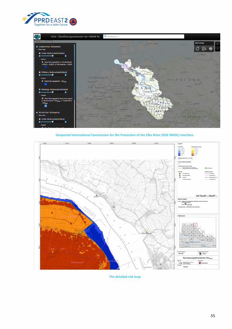
55
GeoportalInternationalCommissionfortheProtectionoftheElbeRiver(IKSEMKOL)interface.
Thedetailedriskmap

56
References
IKSE-MKOLGeoportal http://geoportal.bafg.de/mapapps/resources/apps/IKSE_DE/index.html?lang=de
Recommendations for theEstablishment of Flood Hazard MapsandFloodRiskMaps
http://www.lawa.de/documents/LAWA_HWGK15062010_Text_Germany_ENG_f72.pdf
IrelandFloodHazardandRiskAssessment
Generaldescription
TheOfficeofPublicWorks(OPW)istheleadStatebodyforthecoordinationandtheimplementationofthe Government policy on the management of flood risk in Ireland. The OPW is also the nationalauthorityfortheimplementationoftheEUDirectiveontheAssessmentandManagementofFloodRisks(2007/60/EC).OPWworks inclosepartnershipwithallLocalAuthorities indeliveringtheobjectivesoftheCatchmentFloodRiskAssessmentandManagement(CFRAM)Programme.TheCFRAMProgrammerepresentsanationalstrategyforthereductionandmanagementoffloodriskinIrelandfromthemediumtolong-term.TheProgrammerepresentsacorecomponentsoftheNationalFloodPolicy,adoptedin2004,andoftherequirementsoftheEUFloodsDirective.TheProgrammeiscomposedofthreemainconsultativestages:
− 2011PreliminaryFloodRiskAssessments.− 2014FloodHazardMapping(This involvesthemappingofareasthatareatsignificantrisk
fromflooding.Themapswillshowtheextentoffloodinglikely,howdeepthewatercouldgetandhowfastthewaterwillflow);
− 2015FloodRiskManagementPlans.
Methodology
There is a long history of flooding in the South Western River Basin District (RBD) with Cork City,Bandon,Mallow,Skibbereen,ClonakiltyandFermoyamongthemostvulnerableareastoflooding.TheOfficeofPublicWorksand itspartners,CorkCityCouncilandCorkCountyCouncil,haveundertakenacatchment-based flood risk assessment andmanagement study of the Lee Catchment (River Lee, itstributariesandCorkHarbour)–theLeeCFRAMStudy.TheLeeCFRAMStudyistheprimarypilotprojectforanewnationalapproachtofloodriskmanagementundertheNationalCFRAMProgramme.Theobjectoftheprogrammeistocreateaccuratefloodmapsforareasatsignificantriskfromflooding,develop plans to manage flood risk on a catchment-wide scale as well as promote the activeparticipationofthepublicinaddressingfloodrisk.Thedatafordevelopingfloodriskmapsinclude:
− Recordsofpastfloodevents;− RainfallrecordsthroughouttheRBD;− Runoffrecordsfromriverlevelgaugesthroughoutthecatchment;− Detailed survey informationon thedepth,widthand slopeofall the rivers that contribute to
floodingintheRBD;− Highresolutionfloodplainmaps.
TheLeeCFRAMStudyisnowcomplete.Themainoutputsfromthisstudyarefloodmaps.

57
PredictivefloodmapsareakeyoutputoftheLeeCFRAMStudy.Thefloodmapsproviderepresentationsofareasthatareestimatedtobeinundatedatsomepointduringafloodevent(causedbyeitherriverovertoppingortidalovertopping).Thesemapsarederivedusinginformationfromdetailedhydrologicalanalysisandnumericalhydraulicriver/estuarymodels.Thepredictivefloodmaps,arecategorized intogroups titled 'urban area' and 'rural area' maps. The urban area maps are at a larger scale (moredetailed) than the rural areamaps. The rural areamaps include theareas coveredby theurbanareamapsandareatasmallerscale.Thereare fourmaptypesavailable forviewing - floodextent,depth,velocityandhazardmaps.Floodextent maps represent the areas that are estimated to be inundated by a flood event of a givenprobabilityofoccurrence.
• Flood extentmaps are available for both existing conditions and a projected future scenario,where themaps for future scenarios include allowances for projected future changes in bothclimateandlanduse.Thesemapsalsoshowwaterlevels,flowsanddefendedareas.
• Flooddepthmapsillustratetheestimatedflooddepthsforareasinundatedbyafloodeventofagivenprobabilityofoccurrence.Depthmapsareavailable foranumberofannualexceedanceprobability (AEP) events. The AEP is the estimated likelihood of a particularmagnitude floodoccurringorbeingexceeded inanygivenyear.Thus,a1%AEPeventrepresentsanestimatedfloodeventwhichhasa1% (or1 in100) chanceofoccurringorbeingexceeded in anygivenyear.
• Velocitymaps illustrate the estimated speed of the flood water for a flood event of a givenprobabilityofoccurrence.VelocitymapsareavailableforanumberofAEPevents(thesameasdescribedaboveforFloodDepthmaps).
• Hazardmapsshowtheestimatedharmordangertowhichpeoplemaybeexposedforafloodeventofagivenprobabilityofoccurrence.HazardmapsarealsoavailableforanumberofAEPevents.
Flood risk is a combination of the probability and degree of flooding (the ‘hazard’) and the damagecausedbytheflood(the‘consequences’).Floodhazardcanarisefromarangeofsourcesofflooding,theCFRAMStudyaddressesthefollowingsources:Rivers(fluvial)Sea(coastalandtidal).The following four risk receptor groups are vulnerable to the potential adverse consequences offlooding:Society;Environment;Cultural;andEconomy.TheSocialFloodRiskshallbeassessed,mappedandreporteduponusing fourmethodsand indicatorsets:
− thelocationandnumberofresidentialproperties− thelocation,type,andanindicatorofvulnerabilityandnumberofpotentiallyhighvulnerability
sites,suchasresidentialhomesforchildren,theelderlyordisabled,etc.− thelocation,type,andanindicatorofvulnerabilityandnumberofvaluablesocialinfrastructural
assets,suchasfirestations,police(Garda)stations,ambulancestations,hospitals,governmentandcouncilbuildings,etc.
− thelocation,type,andanindicatorofvulnerabilityandnumberofsocialamenitysites,suchasparks,leisurefacilities,etc.
TheFloodRisktotheEnvironmentshallbeassessed,mappedandreporteduponusingthreemethodsandindicatorsets:
− the location, type, and an indicator of vulnerability andnumberof installations referred to inAnnexItoEUDirective96/61/EC(1996)concerningintegratedpollutionpreventionandcontrolandothersignificantpotentialsourcesofpollution.

58
− the location, extent, nature and an indicator of vulnerability of areas identified in theWaterFrameworkDirective(EUDirective2000/60/EC)
− the nature, location, and an indicator of vulnerability and areas of other environmentallyvaluablesites,suchasSACs.
TheFloodRisktoculturalheritageshallbeassessedandmappedandreporteduponusingonemethodand indicatorset: location, type,an indicatorofvulnerabilityandnumberofsitesorassetsofculturalvalue.TheFloodRisk to theEconomyshallbeassessedandmappedandreporteduponusing fourmethodsandindicatorsets:
− thelocation,type(residentialandclassificationsofnon-residential)andnumbersofproperties,withassociatedfrequency-depth-damageinformationbasedonpropertytype
− thedensityof economic riskexpressedas annual averagedamage (euro / year)perunit area(e.g.,per100mor500msquare)
− thelocation,type,andanindicatorofvulnerabilityandnumber(and/or lengths)oftransportinfrastructuralassets,suchasairports,ports,motorways,nationalandregionalroads,rail,etc.
− thelocation,type,andanindicatorofvulnerabilityandnumberofutilityinfrastructuralassets,suchaselectricitygenerationandsub-stations,watersupplyandtreatmentworks,naturalgasandoilfacilities,importanttelecominterchanges,datarepositories,etc.
Indicatorsofvulnerabilityaretypicallyacategorizationofvulnerability(e.g.,veryhightoverylow)or,anumerical or economic consequence or depth-consequence curve in the event of flooding. Theindicatorsof vulnerability are tobeprovidedbyOPW for each typeof social, environmental, culturalandeconomicriskreceptor.
Outcomes
TheOPWvieweratnationallevelprovidesFloodExtentMaps,FloodDepthMapsandFloodRiskMaps.Maps showing the Specific Types of Economic Activity across Units of Management vary in scaledependingonthesizeofeachUnitofManagement.
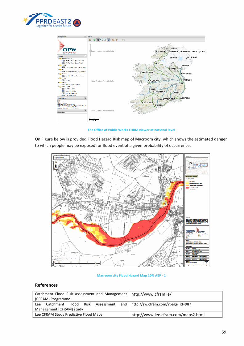
59
TheOfficeofPublicWorksFHRMvieweratnationallevel
OnFigurebelowisprovidedFloodHazardRiskmapofMacroomcity,whichshowstheestimateddangertowhichpeoplemaybeexposedforfloodeventofagivenprobabilityofoccurrence.
MacroomcityFloodHazardMap10%AEP-1
References
Catchment Flood Risk Assessment and Management(CFRAM)Programme
http://www.cfram.ie/
Lee Catchment Flood Risk Assessment andManagement(CFRAM)study
http://sw.cfram.com/?page_id=987
LeeCFRAMStudyPredictiveFloodMaps http://www.lee.cfram.com/maps2.html

60
LinkstoLeeCFRAMstudypredictivefloodmaps http://www.opw.ie/en/leecframs/floodmaps/maps
More information and details on SouthWestern RBDCFRAM Study are provided in Reports (PDF) for eachUoM
http://sw.cfram.com/?page_id=79
OPWFHRMguidance http://maps.opw.ie/fhrm/guidance/OPWViewerofFHRMsatnationallevel http://maps.opw.ie/fhrm/viewer/Predictive flood maps for Baile Mhic Íre town(Ballymakerra)-BaileBhuirnecounty(Ballyvourney)
http://sw.cfram.com/?page_id=987
Technical Hydrology and Hydraulics and FloodMapping Reports are available through the NationalCFRAMProgrammewebsite
www.cfram.ie
ItalyFloodHazardandRiskAssessment
GeneralDescription
TheMinistry of Environment, Land and Sea Protection (MATTM) informed the European Commission
that Italy would made use of the transitional measures, as required by the art. 13.1b of Directive
2007/60/EC, and therefore would not carry out the preliminary flood risk assessment referred to in
Article 4, having decided, before 22 December 2010, to draw up hazard and flood risk maps and
establish management plans for flood risk in accordance with the relevant provisions of the Floods
Directive.
Thisdoesnotexcludetheneedtoprove,uponrequestoftheEuropeanCommission,thatallthesteps
requiredbyart.4oftheFloodsDirective,havebeenconsideredintheidentificationofareasatpotential
riskwherearefocusedthecurrentmappingactivities.
Methodology
The Legislative Decree no. 49/2010 state that the flood hazardmaps and flood riskmaps, should be
preparedinscalepreferablynotlessthan1:10.000and,inanycase,notlessthan1:25.000.Aswellas
theDPCM29/09/1998requiredarepresentationscaleofnotlessthan1:25.000forboththeperimeter
oftheinundationareas(1:50.000onlyforthemostseverescenarioinprotectedareasbysurmountable
embankmentsforareturntimeT=200years)andfortheidentificationofelementsatrisk.
FloodHazardMapping
The reporting of hazardmaps, according to EU Floods Directive 2007/60/CE, is based on a series of
textual information andon geographic information (e.g. shape files andpolygonsof the flood areas).
Text informationforthereportingoffloodmapstobeprovidedbyXMLfilesorACCESStables,whose
contentsandrelationshipsaredefined.TheyconsistinaseriesofSUMMARYTEXTs,inthedescriptionof
the type of floods and possibly of the features and mechanisms associated with them and in the
indicationoftheprobabilityorreturnperiodassociatedtothescenarioofhazard.
Thesummaryinformationincludes:
61
• theextensionofflood(includingtheresolutionofdigitalmodels);
• thelikelihoodoffloodingorreturnperiod;
• heightorwaterlevels;
• speedand/orflowrates(whereappropriate);
The geographic information is represented by polygon type and with an extension of the flood
associated to each flood scenario (high,medium, low likelihoodof flooding). The informationof XML
files (or tablesdbaccess)areassociateduniquely throughalphanumericcodes to individualpolygons,
thatarethefeaturesoftheshapefile.Thecontentsandformatofthedataforthereportingofhazard
mapsaredescribedindetail inthedocument"NotesonthecompletionofAccessDatabasecompliant
forXMLSCHEMEreportingofDir.2007/60/ECArt.6:FloodHazardandRiskMaps"published in the
restrictedareawithinthesectionFloodsDirective2007/60.
TheLegislativeDecreeno.49/2010statesthatthehazardmaps,inadditiontotheheightorwaterlevel,
shouldreportalsothedischargeandthevelocity(mandatory).Furthermore,inlinewithwhatcontained
in the PrimeMinisterial Decree of 1998 each probability scenario is defined by a specific interval of
return period. In Table the information required by the EUFDEUFD and the Italian legislation on the
definitionofscenariosofprobability,expressedintermsofreturnperiod,iscompared.
Probability Directive2007/60/CE LegislativeDecree49/2010
PrimeMinisterialDecree1998
Low(extremeevents) - T≤500years 300≤T≤500yearsMedium ≥100years 100≤T≤200years 100≤T≤200yearsHigh - 20≤T≤50years 20≤T≤50years
TableA.Returnperiods(T)foreachscenarioofprobability.
In theLegislativeDecree49/2010 is requiredthat in thehazardmapsshouldbehighlightedtheareas
wherecanbeexperiencedfloodingwithhighcontentoftransportedsedimentsanddebrisflows.Given
the high frequency of these phenomena in thewhole country, aswell as related effects in terms of
directandindirectdamages,theItalianlegislationintendtoincludetheminthedefinitionoffloods.
TheEUFloodsDirectiveforeseesthatclimatechangeeffectsonhydraulicriskshouldbecounted,based
onobservationsandweather-hydrologicalandhydraulicmodels.
ISPRAInstitutedevelopedaMethodology25(2013)forupdatinghazardandriskmaps.Twomattersare
taken into consideration. The first one is related to the graphic representation, both related to the
heightsandtothewatervelocity.Thesecondoneconcernsthesignificanceofthevaluescalculatedby
one-dimensionalhydrodynamicorquasi-two-dimensionalmodels,orderivedfrommethodsofhistorical
inventory/geomorphologic.
25http://www.isprambiente.gov.it/it/pubblicazioni/manuali-e-linee-guida/Proposta-metodologica-per-l-aggiornamento-delle-mappe-di-pericolosita-e-di-rischio/leadImage/image_view_fullscreen
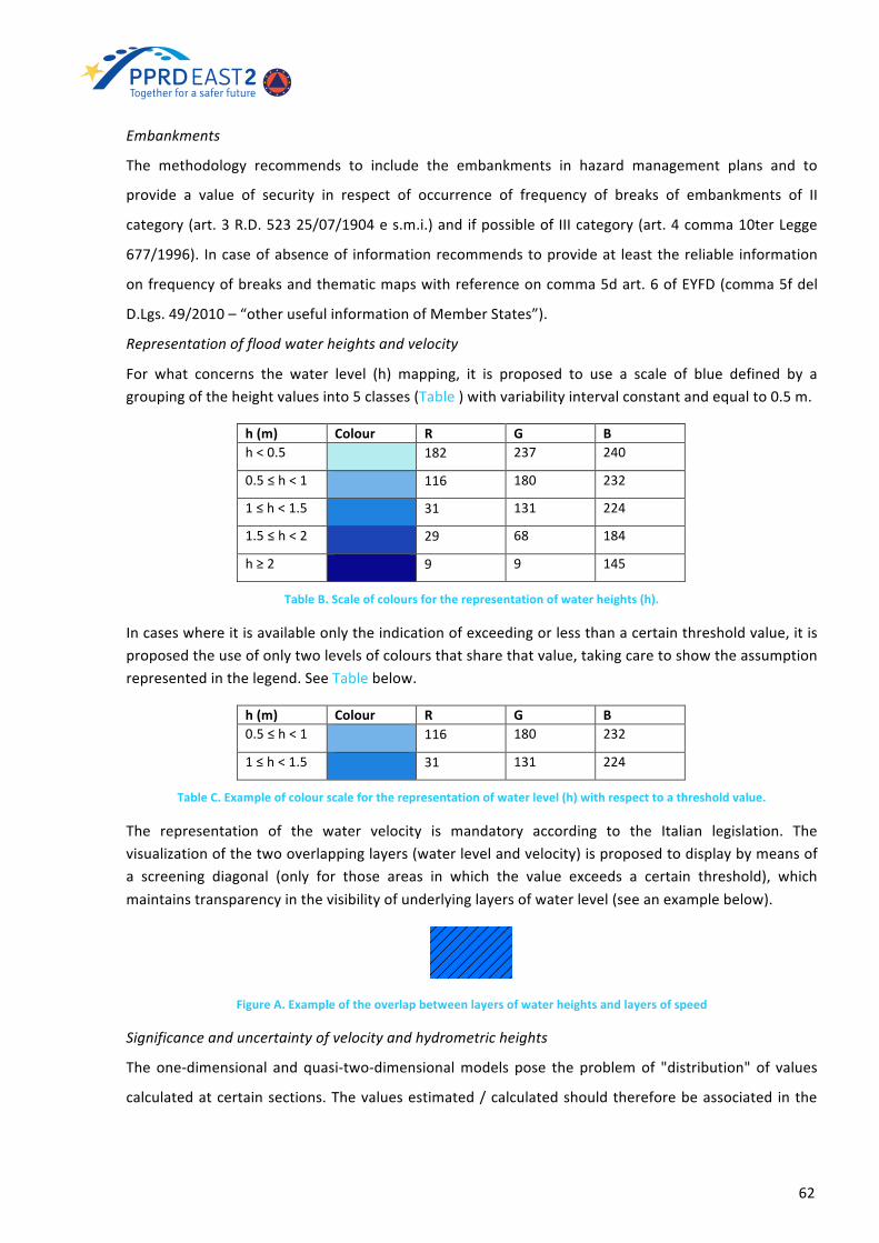
62
Embankments
The methodology recommends to include the embankments in hazard management plans and to
provide a value of security in respect of occurrence of frequency of breaks of embankments of II
category(art.3R.D.52325/07/1904es.m.i.)andifpossibleof IIIcategory(art.4comma10terLegge
677/1996). Incaseofabsenceof informationrecommendstoprovideat leastthereliable information
onfrequencyofbreaksandthematicmapswithreferenceoncomma5dart.6ofEYFD(comma5fdel
D.Lgs.49/2010–“otherusefulinformationofMemberStates”).
Representationoffloodwaterheightsandvelocity
For what concerns the water level (h) mapping, it is proposed to use a scale of blue defined by agroupingoftheheightvaluesinto5classes(Table)withvariabilityintervalconstantandequalto0.5m.
h(m) Colour R G Bh<0.5 182 237 240
0.5≤h<1 116 180 232
1≤h<1.5 31 131 224
1.5≤h<2 29 68 184
h≥2 9 9 145
TableB.Scaleofcoloursfortherepresentationofwaterheights(h).
Incaseswhereitisavailableonlytheindicationofexceedingorlessthanacertainthresholdvalue,itisproposedtheuseofonlytwolevelsofcoloursthatsharethatvalue,takingcaretoshowtheassumptionrepresentedinthelegend.SeeTablebelow.
h(m) Colour R G B0.5≤h<1 116 180 232
1≤h<1.5 31 131 224
TableC.Exampleofcolourscalefortherepresentationofwaterlevel(h)withrespecttoathresholdvalue.
The representation of the water velocity is mandatory according to the Italian legislation. Thevisualizationofthetwooverlappinglayers(waterlevelandvelocity)isproposedtodisplaybymeansofa screening diagonal (only for those areas in which the value exceeds a certain threshold), whichmaintainstransparencyinthevisibilityofunderlyinglayersofwaterlevel(seeanexamplebelow).
FigureA.Exampleoftheoverlapbetweenlayersofwaterheightsandlayersofspeed
Significanceanduncertaintyofvelocityandhydrometricheights
Theone-dimensional and quasi-two-dimensionalmodels pose the problemof "distribution" of values
calculatedatcertainsections.Thevaluesestimated/calculatedshouldthereforebeassociated inthe

63
subsequentphasesofstudy(analysisoftheriskoffloodingandresidualriskassessment)withalevelof
confidence(uncertainty)whichcharacterizesthem.
Areassubjectedtofloodingwithahighcontentoftransportedsedimentsanddebrisflows
For floodeventswithhighcontentof transportedsediments,withorwithoutcharacteristicsofdebris
flow,itisimportanttoidentifyatleastthreehazardlevels(high,mediumandlow).
FloodRiskMapping
The ISPRA Methodological Proposal26 defines the methodology for the damage evaluation. The
significanceandassessmentofdamagearebasedon(i)theintensityoftheevent(ii)thesocial,cultural,
economicandenvironmentalexposureassociatedwiththeitem.
Exposedelements:
a) Theindicativenumberofinhabitantspotentiallyaffected
Theassessmentofthenumberofinhabitantsshouldbecarriedonbyintersectingthecensussectionswiththepolygonsofthefloodingareasand,incaseofpartialintersection,calculatingthenumberofpeoplepotentiallyaffectedasthetotalnumberofinhabitantsassignedtothecensussectionmultipliedbypercentageoftheaffectedarea.
a) Infrastructureandstrategicstructures(highways,railways,hospitals,schools,etc.)
Theinformationdownloadablefromwebsitesofnationalservicesorobtainedfrompublicbodies.
b) Environmentalheritage,historicalandculturalinterestinthefloodablearea.
ThedataofthiscategoryiscontainedbytheItalianMinistryofHeritageandCulturalActivities(MIBAC),possiblysupplementedbyregionalandprovincialsources.
Categorizationofexposedelements
Italianlawidentifiesfourcategoriesofexposedelementsforrisksmaps:population,economicactivities,
culturalheritageandarchaeologicalandenvironmentalassets.
a) ClassificationofEconomicActivitiesintheEuropeanCommunity–sourceNACE,Revision2;
b) Classesoflanduse–thesourceCORINELandCoveratnationalandlocallevel(Table);
ID Classesoflanduseandsourcesofdata1 Residential (includes all elements related to theurban fabric other than those referred to in point
3,4,8,9)2 Commercial(includingcraft)donotcomeundercategory1andindustrial(includingminingareas)3 Hospitals, health care, social worker, (hospitals, nursing homes, homes for the elderly, disabled,
handicapped,etc..),schoolsanduniversities4 Buildingshomeofessentialpublic services (municipalities,prisons,barracks,prefectures,etc ..,not
fallingundercategories1and3)5 Specializedagriculturalland(agriculturallandarable,permanentandheterogeneous)6 Agriculturalunskilled(woodedareas,meadows,pastures)7 Recreational tourism (camping sites, beaches, ski slopes, cinemas, theaters, multipurpose centers,
sportfishing,etc.,Donotcomeundercategory1)
26http://www.isprambiente.gov.it/files/pubblicazioni/manuali-lineeguida/MLG_82_2012.pdf

64
8 Communicationnetworksand transportationprimary (airports,ports,highways, freeways,RegionalRoads,Railways).MATTMNationalGeoportal:http://wms.pcn.minambiente.it/ogc?map=/ms_ogc/wfs/Rete_stradale.maphttp://wms.pcn.minambiente.it/ogc?map=/ms_ogc/wfs/Rete_ferroviaria.map
9 Communicationnetworksandsecondarytransport(roadsProvincialandMunicipal).MATTMNationalGeoportal:http://wms.pcn.minambiente.it/ogc?map=/ms_ogc/wfs/Rete_stradale.map
10 Technologicalnetworksandservices(supplygas,electricity,water,sewage,telephonelines,etc.,Donotundercategory1)
11 Structuresandsystemstosupportnetworkcommunicationsandtransport,technologicalandservice(buildingsandstructuresairportsandports,railwaystations,serviceareas,parkinglots,powerplants,substations,reservoirs,waterpurifiers,etc.,Donotundercategory1)
TableD.Classesoflanduse,sourceCorineLandCover
c) Informationlayerrelatedtoenvironmentalcomponent(Table);
ID Classesoflanduseandsourcesofdata12 Landfills,wastetreatmentplants,wastewatertreatmentplants,whichcouldbeimportantsourcesof
pollutionincaseofflooding(notfallingintothosereferredtoinparagraph13)13 InstallationslistedinAnnexIoftheLegislativeDecreen.59ofFebruary18,2005
http://cart.ancitel.it/index.html?progetto=32598B49-3B4C-4843-A6A6-ED943A2AEE14&map=EEC7E870-CA34-6140-9BA8-1F85DE09C552
14 Protected areas identified in Annex 9 in Part III of Legislative Decree No. 152 of 2006. NationalInformationSystemforWaterProtectionItalian(SINTAI)-Ispra;ManagementPlans
TableE.Informationlayerrelatedtoenvironmentalcomponent
d) Informationlayerrelatedtoculturalandarchaeologicalheritagecomponents(exampleinTable).
ID Classesoflanduseandsourcesofdata15 Assetsofhistorical-culturalandarchaeologicalheritage
TableF.Layerofculturalandarchaeologicalheritagecomponents
Determinationofdamage
The analysis of the damage (D) is made according to the four main categories specified by the
legislation: population (Dp), economic activities (De), cultural heritage and archaeological (Dc),
environmentalgoods(Da).Inaddition,eachcomponentofdamageisassessedintheindividualclasses
of land use. It is assumed that an event of given intensity can cause, against an exposed element, a
damage/totalloss(1),apartialdamage(0÷1)ornodamage(0).
Significanceandassessmentofdamage
a) TheindexesofdamageassociatedwithpeopleareprovidedinFigure.Thedeterminationofthe
damage on the population is analyzed according to two components: the vulnerability
associated to the flood intensity and vulnerability and exposed value expressed in relative
terms.

65
FigureB.Examplesofrepresentationofthepopulationconcerned
5classesofpopulationdensityareidentifiedaccordingtoTablebelowandtoeachofthemisassignedaweightfactor(densityfactor).
Classlimits(inhabitants/km2) Densityfactor1–40 0.940–80 0.9380–140 0.95140–320 0.98>320 1
TableG.Classesofpopulationdensity(ref.ClassesISTAT2001census).
Tablereports,foreachlanduseclass,ahypothesisregardingthedurationofthehumanpresenceintheelementoftheterritoryconcerned.Thefinalvalueoftheexposureassociatedtothepopulationwillbegivenbytheproductofthetwofactorsofpopulationdensityandduration.
IDClassesoflanduse
Classnameoflanduse Estimatedtime(hours)
Durationfactor
1 Residential 24 12 Commercialandindustrial 12 0.53 Hospitals,healthcare,socialcare,schoolsanduniversities 24 14 Headquartersbuildingofessentialpublicservices 24 15 Specializedagricultural 4 0.26 Agriculturalunskilled 2 0.17 Recreationaltourism 10 0.48 Communicationnetworksandprimarytransport 24 19 Communicationnetworksandsecondarytransport 12 0.510 Technologicalnetworksandservice - -11 Structuresandsystemstosupportnetworkcommunications
andtransport,technologicalandservice8 0.3
TableH.Exampleforallocationofthedurationfactor(forland-useclasses)basedonthepermanenceofthepopulation
b) Thedamageassociatedwitheconomicactivities
− for all classes of land use that are characterized by the presence of buildings, the
damageisassessedinrelationtobuildingsandgoodscontainedtherein;
− thedamageforagriculturalareasislinkedtothelossofthecropand,forhighervalues
ofwaterlevelandvelocity,tothebuildingsandgoodscontainedtherein;

66
forclassesoflandusecorrespondingtotheinfrastructurethedamageevaluationisrelatedtotheinabilitytousetheinfrastructureandthereforetheinterruptionofservice.Thiscanoccurwithorwithoutstructuraldamagetocriticalinfrastructures(simplefloodingordestructionoftheproperty).
VulnerabilityassociatedtoeconomicactivitiesThe3categoriesofdamagecorrespondrespectivelyto:
− damage from simple flooding: damages similar to those caused by natural flood lowspeed,withnoimmediatestructuraldamage;
− structuraldamagepartialmoderatedamage,suchaswindowsanddoorsthrowntothegroundandminordamagetothemainstructuralelementsofthebuildings;
− totaldestruction-totalcollapseorseriousdamagetostructuresrequiringdemolitionandreconstruction.
ThevalueexposedassociatedwitheconomicactivitiesIt is necessary to define a scale of relative values taking into account the costs of recovery, of non-production,offailuretousetheservice,etc.Table liststhenamesofthefieldsrelatedtothevariablecensusISTAT"CensusofPopulationandHousing".
IDclasslanduse Classesoflanduse Relativevalue1 Residential 12 Commercialandindustrial 0.73 Hospitals,healthcare,socialcare,schoolsand
universities1
4 Headquartersbuildingofessentialpublicservices 15 Specializedagricultural 0.36 Agriculturalunskilled 0.47 Recreationaltourism 18 Communicationnetworksandprimarytransport 19 Communicationnetworksandsecondarytransport 0.510 Technologicalnetworksandservice 111 Structuresandsystemstosupportnetwork
communicationsandtransport,technologicalandservice
1
TableI.Exampleforallocationofeconomicvaluerelativetothevariousclassesoflanduse.
c) Thedamageassociatedwiththepresenceofculturalheritage;Atpresent therelevant information forestablishingaspecificvulnerabilityof individualassetsdepending on the characteristics of the flood is not available. The differentiation by type(museum, library,historicbuildingormonument, archaeological site, etc.) is howeverdifficultForthisreasonwhenoverlappingthefloodareaswiththelayerof"culturalandarchaeologicalheritage"isusedDc=1fortheassetsinfloodableareaswithouttakingintoaccountthewaterlevelandtheflowvelocity..
d) Thedamageintermsofenvironmentalcomponent;Thecontaminationiscausedbythreemainsources:industry,humanwaste/animals,stagnantwaterspilled.Openspacesrefertoareaswithnaturalenvironmentusedforactivitiesoutdoorrecreation,and

67
touristattractionssuchasnaturereserves.TheapproachtobeproposedistousealayerofProtectedAreas.
Determinationofrisk
a) Specific risk - comes from the combinationof damage andprobability for 3 scenarios hazard,
normalizedtothemaximumspecificrisk.
Totalrisk-toassesstherisktotalisnecessaryforeachscenarioofhazardoverlapthe4gridofdamage:Di=max(Dpi;Dei;Dci;Dai).CalculatingthevalueofSpecificRisk(Ri)withthesameprocedure,theclassofriskwillbeassignedasreportedinTable.
Class–RiskDefinition ValuesRi Color R G BModerate (R1) for which damage to social, economicandenvironmentalheritageismarginal
0<Ri≤0.25 245 245 0
Average (R2) for which is possible minor damage tobuildings,infrastructureandenvironmentalassets,thatdonotaffectsafetyofpersons,stabilityofbuildingsandfunctionalityofeconomicactivities
0.25<Ri≤0.50 245 122 0
High(R3)forwhicharepossibleproblemsforsafetyofpeople, functional damage to buildings andunavailability of infrastructure, interruption offunctionality of socio-economic activities andsubstantialdamagetoenvironmentalheritage
0.50<Ri≤0.75 200 0 0
VeryHigh(R4)forwhichitispossiblethelossoflifeandserious injury, serious damage to buildings,infrastructure and environmental heritage, destructionofsocio-economicactivities
0.75<Ri≤1 112 48 160
TableJ.RangesofvaluesofRiandattributionofrisk.
Thecontentsandformatsofthedatatobeprovidedforthereportingoftheriskmapsaredescribedindetailinthe"NotesonthecompletionofAccessDatabasecomplianttotheSCHEMEforthereportingofDir.2007/60/ECArt.6:FloodHazardandRiskMaps".The LegislativeDecree49/2010 lists inmoredetail the categoriesofelementsat riskadding to thosegivenintheDirectivefurthertwocategories(infrastructureandculturalheritage)..Thelistofelementsatriskconsideredisreportedbelow:• indicativenumberofinhabitantspotentiallyaffected;• infrastructureandstrategicstructures(highways,railways,hospitals,schools,etc.);• environmental, historical and cultural heritage of relevant interest present in the area
potentiallyaffected;• distributionandtypeofeconomicactivitiesintheareapotentiallyaffected;• classesoflanduseandsourcesofdata;• installations listedinAnnexIoftheLegislativeDecree18February2005n.59,thatmaycause
accidentalpollutionincaseofflooding;• potentiallyaffectedprotectedareasidentifiedinAnnex9inthethirdsectionoftheLegislative
Decreen.152of2006;otherinformationdeemedusefulbytheauthoritiesofthebasindistrict,liketheflood-proneareaswithhighvolumeofsedimenttransportanddebrisflowsorinformationonsourcesofpollution.

68
Outcomes
The CNR-IRPI of Perugia, commissioned by theDepartment of Protection, has adapted the cataloguehistorical flood (AVI) to the formats required by the European Commission for the cadastre of floodevents,integratingitwithadditionalinformationrelatingtomajorfloodingthatoccurredfrom2002to2011.Thisallowstohaveauniformdatabasethroughoutthenationalterritory.
References
ISPRA Institute developed a Methodology(2013) for updating flood hazard and riskmaps
http://www.isprambiente.gov.it/it/pubblicazioni/manuali-e-linee-guida/Proposta-metodologica-per-l-aggiornamento-delle-mappe-di-pericolosita-e-di-rischio/leadImage/image_view_fullscreen
Methodological Proposal for UpdatingHazardandRiskmaps,ISPRA,Italy,2012
http://www.isprambiente.gov.it/files/pubblicazioni/manuali-lineeguida/MLG_82_2012.pdf
The layer "Land use - Corine Land Cover2006" is available on the NationalGeoportal MATTM and accessible by WebFeatureService(WFS)
http://wms.pcn.minambiente.it/ogc?map=/ms_ogc/wfs/Corine_Land_Cover2006.map
The repository of exposed elementsNational Geoportal of the Ministry ofEnvironment
http://www.pcn.minambiente.it/GN/
6.3 CurrentStatusofFloodHazardandRiskAssessment inPartnerCountries
InTable6areprovidedmainrecommendations(PPRDEast2CountryProfiles,2015)aresummarisedforeachpartnercountry.ThecurrentstatusonFHRMisdescribedineachparagraph.
EaPCountries
definecommonmethodologiesandtechniquesforFHRMatnationallevel,compliantwithEUFD
elaboratefloodhazardandriskmappingforallunitofmanagementsstartingfromapilotbasin
implementatraining/capacitybuildingprogrammeforNationalinstitutions
Aditional
Azerbaijan V V V
Armenia - - V
Belarus - - V Fund national scaleinitiative
Georgia V - - ApplicationofmethodologyinKuraandRionipilotbasins
Moldova V - V -
Ukraine V - V -
Table9.RecommendationsonFHRMdevelopmentinEaPregion

69
ARMENIA
In Armenia Flood Hazard and Flood Riskmapping have been both carried out during last few years,nevertheless theapproximation level toEUFD isstillquite low.The floodhazardmappingbyNationalAcademy of Sciences, Institute of Geological Science (NAS IGS) is not compliant with the detail levelrequiredbyEUFDandhavenodirectlyrelationtoreturnperiods(i.e.,probabilityofoccurrence),whichisoneofthemainpointsofEUFD.
DuringPPRDEastProgrammePhase1theNASIGShasdevelopedanation-widemappingofthefloodhazard.OtherprojectsrelevanttothetopicistheGermanTechnicalCooperationAgency(GTZ)fundedprogramme“DisasterPreparednessinSouthCaucasus”thatfocusedonLoriandTavushmarzesinwhichNASIGSwasoneoftheimplementerand“ModelGuidelinesForWaterBasinManagementPlanningInArmenia” for the Meghriget River funded by United States Agency for International Development(USAID)(incollaborationwiththeWaterResourcesManagementAgency(WRMA)undertheMinistryofNatureProtection).
Currently, are developing the 6 water basinmanagement plans. The Government of the Republic ofArmenia, inFebruary2011,approvedthecontentoftheWaterBasinManagementModelPlan,whichhasbeendevelopedwithintheframeworkoftheEUWaterinitiative–accordingtotherequirementsoftheEUWaterframeworkdirectiveandWaterCode.Atpresent,thecontentofthemodelplanisalegaldocumentanditisatechnicalassignmentforthedevelopmentofArmenia’sWaterBasinManagementPlans.The3rdand4thchaptersof theWaterBasinManagementModelPlancontain to theemergencyandpreventionmeasures;themeasuresmustbeimplementedwithin6yearsafterthefinalapprovaloftheplansbythegovernment.Currently, in Armenia there are several activities related to the development of a Water BasinManagementPlan:
• Arpa river developed during UNDP - Global Environment Facility Reducing Trans-boundaryDegradationintheKura-AraksRiverBasinProject27
• Akhuryan river under the EU funded project “Environmental Protection of International RiverBasins”(EPIRB28).TheplanwillbesubmittedtotheMinistryofNatureProtectionin2016.
• Model guidelines for water basin management planning in Armenia - Meghriget riverimplementation,fundedbyUSAID.
According to the requirements of the Government protocol decree N4 dated 03.02.2011, the SouthWaterBasinManagementPlandevelopedwithintheframeworkoftheUSAIDCleanEnergyandWaterProgram and the “Ararat valley water basin management plan” developed by the "Armhydroenergoproject" CJSC (the state budget funding) have been submitted to theMinistry of Nature Protection,which in 2016 will be submitted to the Republic of Armenia Government for approval. The WaterResourceManagementAgencyunder theMNP is thenational focal reference for them.Even if theseinitiativesaremuchmoreorientedtotheWaterFrameworkDirectivethanEUFD, itseemstoustoberelevant to cite them as Water Basin Management Plans should include emergency plans (watermanagement during emergencies) anddisaster recovery plans.Moreover, regardless of the fact that,generallyspeaking,thefloodriskisnotassessed,aregisterofhistoricalfloodsissetupveryoftenandacensusofnaturalandartificialwaterbodiesarereportedaswell.Forinstance,afullcharacterizationoftheMeghriget River Basinwas completed in theUSAID project and published as Synthesis Report of27(UNDP/GEFKuraAraksProjectatlinkhttp://www.kura-aras.org)28(ENPI-EPIRBprojectatlinkhttp://blacksea-riverbasins.net/en)

70
MeghrigetRiverBasinCharacterization, also includinga full descriptionof the climate, hydrology andwater quality, biology, geography, socio-economic situation, water use, water balance, major waterresource issues of the basin and flood characteristics among them. Within this project, a section isdedicated to the guidelines for the calculation ofmaximum flow (floods) for both instrumented andnon-gaugedrivers (see thereferencesprovided forPPRDEast1).Alongthesame lines, information isprovided for historical flooding experiences, calculated peak flows and flood flood-prone areas andfloodprotectioninfrastructures.Finally,regardtotheprescriptionsofEUFD,itissignificanttohighlightas one of the outcomes of the project is a wide production of maps (with a varying scaling from1:175,000to1:200,000)ofseveralgeologicalandhydro-geologicallayerssuchas:drainageareasofthesub-basins,averageheight,soilcomposition,annualprecipitation,etc.
AZERBAIJAN
The current state of flood hazard and riskmapping is at early stage and no substantial activities arepresentintheCountry.ThereisaneedtoelaboratefloodhazardandRiskmapsforalltheAreaswithPotentialSignificantFloodRiskidentifiedbyPFRA.
DuringPPRDEast1anation-widefloodhazardandriskmappingatNUTS2levelhasbeendevelopedbyapplyingthemethodologydevelopedbyPPRDEast1andbasedon4 levelsofrisk(compliantwithEUGuidelinesonRiskAssessment).TheresultsareavailabletoregisteredendusersontheERRAplatform.
BELARUS
FHRM is mostly taken care of by means of pilot projects, like the ones on Western Bug, Pripyattributaries (Styr, Prostyr, Yeselda) and Iput and these projects represent a sound basis for the fullimplementationofEUFD.FLOOD-WISEProject(2010-2012)wasdevelopedbytheDistrictOfficeofWlodawabetweentheDistrictOfficeofWłodawa(Poland),CentralResearchInstituteforComplexUseofWaterResources(CRICUWR)(Belarus),NationalUniversityofWaterManagementandNatureResourcesUse(Ukraine)andfundedbythe InterregionalCooperationProgrammeINTERREGIVC,andtheEURegionalDevelopmentFund.FortheWesternBug transboundaryareas a flood risk assessment studyhasbeen carriedout.High flowprobabilities scenarios (1%, 5%, and 10% on a yearly basis)were investigated bymeans of statisticalhydrologicalmethodsbasedonobserveddata(providedbytheHMSoftheRepublicofBelarus)anda1-DhydrodynamicmodeldevelopedbyCRICUWR.FHMsandFRMswitha1:50,000resolutionreportingwater depths scenarios for the selected return periods have been drafted for allWestern Bug basin.FinallyafullycompliantwithEUFDprescriptionsdraftofaFRMPwasdeliveredasthelastdeliverableoftheProject.
UNDP project “Flood Risk Assessment andMonitoring in the Pripyat Basin” (2013-2015) focused onpromoting environmental sustainability through regional cooperation. Among other achievements ofthe project are Flood Hazard and Flood Risk maps for the Yeselda river at a scale of 1:25,000 fordifferentprobabilityscenarios(0.5%-1%-10%-25%onayearlybasis).
GEORGIA
FHRMareavailableatnationalscalebuttheyneedtobeproducedinmoredetailedresolutionsothattheycanbeproperlyusedforthedevelopmentofmitigationmeasures.Specifically,theonesproduced

71
by the MATRA project are not in full compliance with the EUFD as they are limited to be flooddelineationmapsanddonotreportthemaximumwaterdepthvaluesassociatedtothedifferentreturnperiods.However,thenewpilotstudyontheRioniRiverseemstobeinfullcompliancewiththeEUFDIndications.
Anation-wide flood riskmappinghasbeendevelopedduringPPRDEastProgrammePhase1byEMAusingtheinformationlayerprovidedbyNEAthroughtheMATRAproject,takingadvantage,aspointedout, of the already developed nationwide hazard and risk mapping. The countrywide flood riskclassificationdevelopedduringPPRDEastPhase1isa4-levelzonationofGeorgiaatdistrict-scale.
Thehazardmaps,thataremorefrequentlyfloodextensionmapsrelatedtospecificreturnperiodsaresent to EMA for validation risk evaluations. EMAon thebasis of suchmapsperforms local validationwith surveys and local population inquiry. On the basis of such local inquiry the concerns about theHazardmapsareannotatedandsentbacktoNEAforupdate.The finalmap is thensent toEMAthatperforms risk considerations based on the layering of Exposed elements onto the hazard map anddetailscountermeasurestobeputintheemergencyresponseplanandmitigationmeasurestoreducerisk.SuchmitigationmeasuresarefiledinaLetterofRecommendationtothelocaladministrationthatcaninturnevaluateiftheycanactonlocalbudgetorincaserequestnationalbudgetthroughEMAorMENRP.
MOLDOVA
ThesituationofFloodHazardandRiskMappingissimilartoPFRA.FHMsandFRMshavebeenpreparedbyBetaStudioandHRWallingfordforthemainriversofMoldovaundertheProgramme“ManagementandTechnicalAssistanceSupporttoMoldovaFloodProtection”.FHMsandFRMshavebeendevelopedwith state-of-the-artmodelling suites, however there is a need to develop and adopt amethodologythatwillensureahomogeneouselaborationofFHMsandFRMsinthewholecountry.
MoE,withthefinancialsupportoftheEuropeanInvestmentBank,isimplementingtheProgramme“ManagementandTechnicalAssistanceSupporttoMoldovaFloodProtection”.TheProgrammehastheobjectivetodevelopamasterandinvestmentplanforfloodprotection.AspartoftheProgramme,thetechnicalassistancehasbeentenderedwiththeaimof:
1. preparingPreliminaryFloodRiskAssessmentforMoldova,2. elaboratinghazardandriskmapsforthemainrivers,3. identifyingfloodriskmanagementmeasures,4. preparingaGIS-basedriverbasininformationplatform,5. providing capacitybuilding forMoEand subordinated structuresonhydraulic and risk
modelling.BetaStudioandHRWallingfordimplementtheProgramme,itisintheclosurephaseandhazardandriskmapsformainrivershavebeendeveloped.During PPRD East Phase 1, a nation-wide flood hazard and risk mapping at NUTS2 level has beendevelopedbyapplyingthemethodologydevelopedbyPPRDEastandbasedona4-levelriskassessment(compliantwithEUGuidelines).TheresultsareavailabletoregisteredendusersontheERRAplatform.
72
UKRAINEThe FHMand FRMbasedonEU standardshavebeen carriedoutonly for themost important basinswithoutageneral coordinationandhomogeneousapproach.Atanational level,hazardmapsarenotaccessible to public. The coverage is fragmented often with potential substantial methodologicaldifferences.UkrainianHydro-MeteorologicalCenter(UHMI)developedmaps(1996)forinundationgoingbeyondthemaximum consumptionwith a probability of 1, 5, 10 and 25% for the Desna river from the nationalbordertotheriver’smouthandfortheDniesterriveronthefollowingarea:Strilkyvillage–Halychcity–Zalishchykycity.Themapswerecomputedusing1:25000topographicmapsandareavailableonlyonpaper. They are not convenient for operational situation assessment and administrative decision-making. Paper topographic maps are accompanied by the list of population centres along the area(river),theirdistancefromtheriver’smouthandcomputedconsumptionofwaterhavingaprobabilityof1,5,10and25%intheirregion.GISANALYSTmapping tool, developedbyUHMI for the SES, provides flood-proneareas for themainriversofTranscarpathia(Tisa,Borzhava,Oh,Latorica).The countrywide flood risk classification developedduring PPRD East Phase 1 is a 4-level zonation ofUkraineatdistrict-scaleanditisavailableforregisteredendusersontheERRAplatform.DuringFLOODWISEproject(2010-2012)highflowprobabilitiesscenarios(1%,5%,and10%,onayearlybasis) were investigated by means of statistical hydrological methods based on observed data. ThehydrologicalobservationsonBugRiverandsometributaries(forUkraine’sterritory)wereprovidedbyVolynHydro-MeteorologicalCentre(Lutsk)andWesternBugBasinWaterDepartment(Lutsk).FHMsandFRMswitha1:50000resolutionreportingwaterdepthsscenariosfortheselectedreturnperiodshavebeendraftedfortheentireWesternBugbasin.
The Integrated Tisza River Basin Management Plan was delivered by State Committee of WaterManagement of Ukraine (Trans-Carpathia Water Management Board) comprising a topographic andgeodesic survey, thehydrological assessment and thehydraulic calculations and inundation zones fortheaforementionedprobability.
IntheframeworkofEnviroGridsFP7project(April2009toMarch2013)thefloodextent(inspaceandtime) and associated flooddepthhavebeendetermined forDanubeDelta using a twofold approach.Themaps were designed for a real event in the past, as well as for different synthetic storms withdifferentstatisticallydeterminedreturnperiods.Aportfolioofsyntheticsimulatedeventswassimulatedwiththehydrodynamicmodelendingupinacloudofstageanddischargevaluesfor125differentcrosssections.AteachlocationanextremevaluefunctionwasfittedforstagestocomputeFRMsfordifferentreturnperiods(5,10,20and50years,respectively).
6.4 GuidanceandMethodologiesforFloodHazardandRiskAssessment
ThePPRDEast1 study includes in theRiskAssessmentProcess threecomponents:Risk identification,RiskanalysisandRiskevaluation.Risk Identification - identifying sources of risk, areas of impact, events and their causes and theirpotentialconsequences.RiskAnalysis -developinganunderstandingoftheriskthroughspecifichazard,vulnerabilityandassetassessments.
73
Risk Evaluation - evaluation of the risk analysis process is undertaken to assess which risks warrantgreater consideration, this allows for a priority list for treatment strategy implementation to bedeveloped.Accordingly toPPRDEast1Risk/HazardAssessmentPolicy29,anAsset characterizationprocess shouldbe conducted in two stages, in order to make the process efficient. In populated and significantlyindustrializedregionsthistaskmaybecamecomplex.Twostagesare:
− Thetopscreeningstagewheretheimportanceoftheassetisassessed;− Thesecondarystagewhereassetsareselectedexaminedinmoredetailandusedinanalysis.
Stage1-TopscreeningGatheringbasicdataforallassetsincludingsize,location,structure,age,purposeofthefacility/asset,initialestimationofimportance/consequenceifitweretobediminished/fail.Additionaldatamatchedtothehazardriskassessment,assumingtheworstcase–forexampletypesofmaterialstored(toxicity),maximumfatalities,andseriousinjuries,financialandeconomiclosses.Greatprecisionisnotrequiredatthisstageasitismerelyusedtoexcludelowconsequenceitemsfromfurtherassessment,butretaintheir record in the event that changes are recognized or the asset is required as part of a disasterrecoveryplan.Stage2-AssetSelectionThenextstageisimportantintakingtheremainingassetsforwardtoafullcharacterizationprocesssothattheycanbeusedinsubsequentthreat,vulnerabilityandconsequenceanalyses.TodothisthestepsinTable10belowshouldbe followedanddatacomingoutofeachsteprecorded. It shouldbenotedthattherewillbeasignificantdegreeofre-iterationbetweensteps1to3,andthatstep3isinparticulardependentonthescale/levelbeingadopted(e.g.specificorganization/operation,localorregional)ofthe assessment. These 3 structured stages enable the characterizationof the various physical, logicalandresourcefactorsthatmayberequiredinsubsequentanalyses.Step5)canbedefiningstepsinceiftheconsequenceisn’thightheviewmaybetakenthatfurtheranalysisisn’twarranted.Step Task Details1 Identifycriticalfunctions Identify critical functions of the asset at the appropriate
level(local/regional)2 Identifycriticalassets Identifycriticalassets/componentsofthatenable1)above3 Identifycriticalinfrastructures Identify critical internal and external infrastructures (scale
dependent)andanydependencies4 Identifyexistingcountermeasures Identify what protects the functions and assets in 1) -2)
againstthehazards/threatsenvisioned(e.g.buildingcodes,contingencyplans,redundancy)
5 Identifypotentialconsequences Identifythepotential(worst)consequences/impactstotheassetsandfunctionsfromdisruptionandtotalloss
6 Select assets for next stages inanalysis
From4)and5)developarankedlistofcriticalfunctionsandassets which will be used in further risk and resilienceanalysis
29(PPRDEast1Risk/HazardAssessmentPolicyfortheENPIEasternRegion(2012)atlinkhttp://euroeastcp.eu/assets/files/Publications/Risk%20Hazard%20Assessment%20Policy_en.pdf)

74
Table10.AssetCharacterizationSteps
Once captured this data from the selected assets can be taken forward to the vulnerability andconsequenceanalysisstagesofthehazardriskassessment.Hazard risk assessments are typically undertakenby specific hazard focused institutions,Governmentministries and other entities. Themaps are developed through the interpretation of historical data/reports,currentrecordingtechniquesandexpertopinion.Whenconsidering thescopeof thisproject thedevelopmentofhazardmapsareparticularly relevantwhendeterminingtheriskassociatedwiththepossibleoccurrenceofseismicevents,flooding,drought,forestfiresandchemicalaccidents.AssessmentandpresentationmethodscoveringalltypesofhazardsadoptedbythedifferentPartnerCountriesneedtobeconsistentregardingtheirdataoutput.VulnerabilityassessmentVulnerability assessments are also an essential element of local community preparedness. Byunderstanding local vulnerabilities measures can be implemented to reduce their exposure to thepossible onset of a disaster. Community participation is known to assist their own development byempoweringaffectedindividualstoimprovetheirowncapacitytoanticipate,cope,resistandrecovertotheonsetofdisasters.

75
7. FloodRiskManagementPlans
In 7.1 is given an overview of EUFD main requirements on Flood Risk Management Plan. In 7.2 asummaryonstatusofdevelopmentofFloodRiskManagementPlans inPartnerCountries isprovided.The information collected during NAGmeetings in 2015 and reported in Country Profiles of PartnerCountries is included. In 7.3 divided into two subsections 7.3.1 WMO approach on Flood RiskManagement Plan and 7.3.2 PPRD East1 study on Risk/Hazard Assessment are provided. In finalparagraph7.4aresumptiveofGuidanceonFloodManagementPlandevelopmentcomposedofFloodsDirective, WMO and PPRD East1 recommendations and components for formation of flood riskmanagementsystems.
7.1 TheScopeofFloodRiskManagementPlansbyEUFD
AsdefinedbyFloodsDirectiveEuropeanMemberStatesshouldprovideFRMPsbytheendof2015.
Statesshallestablish(Article7)appropriateobjectivesforthemanagementoffloodrisksareasfocusingon the reduction of potential adverse consequences and on non-structural initiatives. Flood riskmanagementplansshalltakeintoaccountrelevantaspectssuchascostsandbenefits,floodextentandflood conveyance routes and areas which have the potential to retain flood water. Flood riskmanagement plans will focus on prevention, protection, preparedness, including flood forecasts andearlywarningsystemsandtakingintoaccountthecharacteristicsoftheparticularriverbasinorsub-basin.
Flood risk management plans may also include the promotion of sustainable land use practices,improvementofwaterretentionaswellasthecontrolledfloodingofcertainareasinthecaseofafloodevent. In the interestsof solidarity, flood riskmanagementplansestablished inone country shallnotinclude measures which, by their extent and impact, significantly increase flood risks upstream ordownstreamofothercountriesinthesameriverbasinorsub-basin.
MainStepsforfloodmanagementplandevelopmentStep 1. In the River Basin Management Plan there is a catalogue of measures. Quantify theconsequencesthatthesemeasureswillhaveonfloods.Step2. Incasetherearemeasuresthatwillhaveannegativeeffectonfloods,reconsiderthem.Studythemeasuresinanintegratedwaytoseewhetherthisproblemcanbesolved(seeaswellStep3).Step 3. Creations of synergy between measures proposed by the two directives: Water FrameworkDirectiveandFloodsDirective.Step4.Inclusionthepublicconsultationintheprocess.Step 5. Organization of the process of finalization of RBMPs and FRMPs in such a way that publicparticipation,officialapprovalandreportingtowardstheEUrunsparallelasmuchaspossible.CoordinationbetweenFloodRiskManagementPlansandRiverBasinManagementPlansAccording to the Floods Directive, development of River Basin Management Plans under WaterFramework Directive 2000/60/EC and of Flood Risk Management Plans under this Floods Directive2007/60/ECareelementsof IntegratedRiverBasinManagement.Theobjectivesof thetwoDirectivesshouldbeinline.
76
ListoftypesofmeasuresforFloodRiskManagement
In terms of the Risk Management cycle, the document "Guidance for Reporting under the FloodsDirective(2007/60/EC)"30,providesinformationonthestepstobeperformed(Table11)
Aspects of flood riskmanagement
Description
NoAction NomeasureisproposedtoreducethefloodriskintheAPSFRPrevention Preventingdamagecausedbyfloods:
(1)byavoidingconstructionofhousesandindustriesinpresentandfutureflood-proneareas;(2)byadaptingexistingreceptorstotheriskoffloodingandensurethatfuturedevelopmentstakefloodriskintoaccount;(3)bypromotingappropriateland-use.
Protection Takingmeasures,bothstructuralandnon-structural,toreducethelikelihoodoffloodsinaspecificlocation
Preparedness Informingthepopulationaboutfloodrisksandwhattodointheeventofaflood;includingemergencyresponse:developingemergencyresponseplansinthecaseofaflood.
Review/Lessonslearnt Returningtonormalconditionsassoonaspossibleandmitigatingboththesocialandeconomicimpactsontheaffectedpopulation.
Other Othertypeofmeasure
Table11.StagesofFloodRiskManagementCycle
7.2 Overview of Current Status of Flood Risk Management Plan inPartnerCountries
The information on current status of Flood RiskManagement is based on NAGmeetings survey andCountryprofiles reportsof2015. InTable11aresummarisedgeneral stateoncurrentstatusofPPRDEast2partnercountriesonFRMPimplementation.
EaPCountries FRMPoperatinginthecountry
Azerbaijan Notdeveloped
Armenia Aredevelopedformajorrivers
Belarus Indevelopmentformajorrivers
Georgia Notdeveloped
Moldova Notdeveloped
Ukraine Notdeveloped
Table12.FRMPdevelopmentstatusinthepartnercountries
ARMENIA
Water basinmanagement plans are in their final stretch for at least 4major Armenia‘s catchments,nonetheless they are much more focused on water quality and water supply. For this reason, it isrecommendedtoincludefloodriskmanagementprinciplesinlinewithEUFD.
30(GuidanceforReportingunderEUFDatlink:https://circabc.europa.eu/sd/a/acbcd98a-9540-480e-a876-420b7de64eba/Floods%20Reporting%20guidance%20-%20final_with%20revised%20paragraph%204.2.3.pdf)

77
It is noteworthy to recall that EUFD-compliant FRMPs also consist of an effective EWS. Armenia hasalready in place a system forweather and flood forecasting (managedby the StateArmenianHydro-meteorologicalService)andresponse(MTAES).
Nonetheless,forafurtherdevelopmentofthewholesystem,itisrecommendedtoimprovetheefficiencyoftheobservationalnetwork,increasingthenumberofautomatedstations(raingauges,thermometers,hydrometersetc.).
AZERBAIJAN
CurrentlytherearenoFRMPsoperatinginthecountryandneitheraplantodevelopthem.ThereisaneedtodevelopFRMPandidentifystructuralandnon-structuralmeasuresforfloodriskreductionandmitigationaccordingtotheindicationoftheEUFD.TheFRMPshouldbetheplanningdocumentsfortheidentification and prioritization of the flood defence infrastructure designed and realized by theCommitteeofLandReclamationandWaterResources(LRWMOJSC).Furthermore,FRMPhastoincludetheestablishmentoftheNationalEarlyWarningSystemofAzerbaijan.
ItisrecommendedtodevelopFRMPsforalltheUnitofManagementofthecountry,startingfromapilotbasin.TheFRMPneedstobe integratedwiththeRiverBasinManagementPlanasrequiredbytheEUWaterFrameworkdirectiveandEUFloodsDirective.Itisfurtherrecommendedtoestablishamechanismfor the effective implementation of the FRMP including the National Early Warning System and tostrengththeobservationalnetwork.
BELARUS
CurrentlytherearenooperationalRBMPsinthecountry,adraftisavailableonlyforUpperDnieperandthe development of RBMPs for 5 main rivers (Upper Dnieper, Pripyat, Western Bug, Nieman andWesternDvina) isunderway.Nonetheless,thefocusoftheseplans isonwaterqualityandfloodsareaddressedmarginally.Forthisreason,itisrecommendedtoincludefloodriskmanagementprinciplesinlinewithEUFD.
Belarus has already in place an effective system for weather and flood forecasting (managed by theStateHydro-meteorologicalServiceundertheMoNREP)andresponse(MoES).Nonetheless,forafurtherdevelopmentofthewholesystem,itisrecommendedtoimprovetheefficiencyoftheobservationalnetwork,increasingthenumberofautomatedstations(raingauges,thermometers,hydrometersetc.).In response to this recommendation theMoNREPhighlighted that according to theResolutionof theCouncilofMinistersoftheRepublicofBelarusof20June2013#503"OnCertainIssuesoftheMONREPoftheRepublicofBelarus",thecompetenceoftheMinistrydoesnotincludetheissuesoffloodhazardandriskprevention,includingthoserelatedtodevelopmentoffloodriskmanagementplans.Moreover,under national legislation including the one considering the administrative and territorial local self-governancesystem(oblast,rayon),itisopinionoftheMoNREPthattheactions(aspartofroadmaps)proposedbyinternationalexpertswithrespecttotheGovernment,theMoNREPandBasinCouncilsarepremature.
GEORGIA
Currently therearenoFRMPsoperating in the country. TheNEAandEMAarebothawareabout theneedtodeveloptheplanand,atthepracticallevel,partsoftheFRMPsalreadyareimplementedinthe

78
form of recommendations to local authorities. This needs to be taken up at the legislation level andclearresponsibilityfordevelopment,implementationandupdateoftheplansneedstobeestablished.Itisrecommendedtoupdateofthecurrentlegislationonriverbasinmanagementplans.ApplicationoftheEUFDprescriptionstoRBMPs.Purchase,installationandcalibrationofautomatedstationsfillingthegapsleftbypilotprojectsalreadyinplace.
MOLDOVA
Currently there areno FRMPsoperating in the country and there is a need to identify structural andnon-structuralmeasuresforfloodriskreductionandmitigationaccordingtotheindicationoftheEUFD.FRMPsneedtobeintegratedwithRBMPsand,specifically,withtheonesalreadydevelopedforDniesterand Prut rivers and some sub-basins. FRMPs need also to include an early warning system and tointegratelocal,territorialandstatedisasterandcivilprotectionplans.It is recommendedtodevelopFRMPs forall theUnitsofManagementof thecountryandto integratethemwith the RBMPs as required by bothWFD and EUFD. It is further recommended to establish acontrol mechanism to periodically check-up the effective development and implementation of theFRMPs.
UKRAINE
River basin management plans have not been formulated conclusively. Measures are much morefocused on water quality and water supply for different use. It is noteworthy to recall that EUFD-compliantfloodriskmanagementplansalsoconsistofaneffectiveEarlyWarningSystem.Ukrainehasalready in place an effective system forweather and flood forecasting (managed by the UHMC) andresponse(SES).For a further development of thewhole system it is recommended to include flood riskmanagementprinciplesinlinewithEUFDintotheriverbasinmanagementplansandtoimprovetheefficiencyoftheobservational network by modernizing, reequipping technically and technologically, increasing thenumberofandfurtherdevelopingautomatedstationsengagedinmeasuringwaterlevels,rainfalletc.
InTable12 recommendationsonFRMP topartner countriesdevelopedafterNAGmeetings2015areprovided.
EaPCountriesupdate of thecurrentlegislationonRBMPs
include flood riskmanagementprinciples in linewithEUFD
develop FRMPsforalltheUnitsofManagement
improve theefficiency of theobservationalnetwork
Azerbaijan V V V
Armenia V
Belarus V V
Georgia V V V
Moldova V
Ukraine V V
Table13.RecommendationstoEaPcountriesonFRMPdevelopment(NAGmeetings2015)
TheFloodRiskManagementplansinpartnercountriesgenerallydemonstratelackofreadiness.Usuallythefloodriskmanagementprinciplesaredevelopedonlyatlocallevel/partiallyandneedtobebrought

79
inlinewithEUFD.Theobservationalnetworkfrequentlyisinsufficient.Thedefinitelegislationandclearresponsibilityfordevelopment,implementationandupdateoftheplansshouldbedesigned.AmongthemainrecommendationsonFloodRiskManagementprocessdevelopment,providedinCountryprofilestopartnercountries,are:
- updateofthecurrentlegislationonRBMPs- includefloodriskmanagementprinciplesinlinewithEUFD- developFRMPsforalltheUnitsofManagement- improvetheefficiencyoftheobservationalnetwork
Armenia,Georgia,MoldovaandUkraineareselectedsupportfortheApproximationtoEUFloodsDirectiveamongpriorityactivities.
7.3 Review of International Guidance on Flood Risk ManagementPlanning
InthissectionareprovidedWMOGuideforIntegratedFloodManagementrecommendationsandPPRDEast1 integrated studyonRisk/HazardAssessment.TheWMOGuideemphasize the important roleoffloodsinmaintainingthenaturalfunctionofriverandfloodplainsandalsoassourcesoffreshwaterandothernaturalresources.ThePPRDEast1policy includesonthehazardriskmanagementframework inthecultureandpractiseoftheGovernmentsystems.
7.3.1 WMOGuideforIntegratedFloodManagement
TheWMOGuide for Integrated FloodManagement31 provides the contents and basic procedures ofbasinfloodmanagementplanning.ThisGuiderepresentsanadditionalsourceofinformationonFRMPdevelopment.Several fundamental issuesrelatedtothefloodmanagementplanning,suchasnationaldevelopmentof vision/policy and enablingmechanismof floodmanagement planning, are explained.The flood management policy should be closely aligned to the water resources development andmanagementanddesignedseparatelyfromdisastermanagementpolicies.
The “Integrated FloodManagement” (IFM)means harmonization of human behavior in relationwithriverregime.InthisrelationtheevaluationofbeneficialfunctionoffloodsandnegativeconsequencesoffloodrisksisthefirststepindevelopingofaFloodManagementPlan.
AccordingtoWMOrecommendationstheBasinFloodManagementplanningshouldreflecttheoverallvisionandpolicyofIntegratedWaterResourcesManagement(IWRM)withparticularattentiononthemanagement of floods. IWRM approach has been accepted internationally as the way forward forefficient, equitable and sustainable development and management of the world's limited waterresources and for coping with conflicting demands. The basic cycle for developing an IWRM plan asgiveninFigure5.
31(Formulatingabasinfloodmanagementplan,WMO,2007;http://www.apfm.info/publications/tools/Tool_01_Basin_Flood_Management_Plan.pdf)

80
Figure9.TheCycleforDevelopingandAdjustinganIWRMPlan32
BasinFloodManagement is recommendedtobe ledby theassignedauthorityorgroupofauthoritiesthathaveresponsibilitiesoffloodmanagementandbasinplanning.TheIntegratedFloodManagement(IFM)isanintegralcomponentofIntegratedWaterResourcesManagementandshouldbeformulatedinclosecoordination.
CommonthemesfortheFloodRiskManagementPlanandtheRiverBasinManagementPlanare:• Maintenance of natural dynamic water courses (protection/restoration of floodplain areas,
restoration of meander of rivers, solid transportation, etc.) and the wetlands, includingimprovementofknowledge.
• Rivermaintenance, avoiding the possible contradictions between the objective to reach goodecological status of surface water bodies and measures to reduce flood risks, for instanceecologicalrestoration,vegetationmaintenanceorlogssuppressiontomakethefloweasier.
• Runoffanderosioncontrol.SpecificthemesfortheFloodRiskManagementPlanare:
• Landmanagementinordertoreducevulnerabilityofgoods;• Structuralmeasureslikedamsordikes;• Publicawareness,publicinformation,consciousnessofthefloodrisk;• Preparednessandcrisismanagement;• Floodforecast,earlywarning;
32(IntegratedWaterResourcesManagementPlans,TrainingManualandOperationalGuide(2005)CapNet,GWPandUNDPatlinkhttp://www.gwp.org/Global/ToolBox/References/IWRM%20Plans%20Training%20Manual%20(Cap-Net,GWP,UNDP,%202005)%20ENGLISH.pdf)

81
• Diagnosisandknowledgeofstakesandvulnerabilities;• Hazardknowledge.
Figure10.StepsonBasinFloodManagementPlanning33
Figure6providesmainstepsofBasinFloodManagementPlanning.Thebuildingofcapacityofdifferentstakeholdersmayrequireanenabling legalandinstitutionalframework. Inan internationalriverbasinthestakeholders,dividedunderdifferentnationalgovernmentstructures, involvementbecomesmorecomplex.
DataSurveyandAnalysisThedifferentcategoriesofdataandanalysisarerequiredtounderstandthefloodissues,evaluatethecurrent socio-economic conditions and the impacts of floods, project the future scenarios ofdevelopmentandclimatechangeandtheecologicalconsequencesfortheformulationofthebasinfloodmanagementplan.Basincondition:Meteorologicaldata;Hydrologicaldata;Geomorphologicdata;Environmentaldata.Socialandeconomiccondition:
• Landusepracticesinthebasinincludingfloodplains
33WMOFormulatingaBasinFloodManagementPlan–AToolforIntegratedFloodManagement,2007

82
• Patternofhumansettlementsinandaroundfloodplains• Demographicprofileoffloodplaininhabitant• Locationofnaturalresources• Livelihoodsourcesinandaroundthefloodplains• Infrastructureandotherassetsinthefloodplains• Futuredevelopmentplaninthebasin• Socialandeconomicdamagesinthepastflood
An expert groupmay serve as the basis for continuous monitoring of data before, during and afterimplementationoftheplan.ImpactsoffloodsIn a river basin, development activities on the flood risks can impact the flow regime (ex. changes intimingandvolume,andqualityof floodwaters) and/or increaseexposureofeconomicactivities. Theoverallreviewofvariousdevelopmentpoliciesonthefloodrisksisanessentialfirststep.InTable13isgiven a partial list of possible impacts.More detailed explanations on range of environmental issuesinvolved in flood management are provided in WMO “Environmental Aspects of Integrated FloodManagement”34 (2006). This publication provides recommendations on flood risks management inrelation to environmental concerns and sustainable development, and looks how environmentalconsiderationscanbeappropriatelyincorporatedinfloodmanagementpractices.
Nationaldevelopmentpolicy LikelychangesinFlowregime Exposuretoflooding
Agriculture Fishery
Forestmanagement Industry
Urbandevelopment Environmentalmanagement Socialconditionimprovement
Others
Table14.Floodrisksimpact
7.3.2 PPRDEast1RegionalRiskManagementPolicy
The PPRD East1 study on Risk/Hazard Assessment35 defined common themes and components ofRegional RiskManagement Policy, considering EU best practisewhile also tailored accordingly to therealitiesandconstraintswithinthepartnercountries.ItconsideredasanintegralpartoftheHazardRiskManagement Framework and should be embedded in the culture and practise of the Governmentsystems.
Themes Components DescriptionCommunication Government
sectorsMandatesandPolicestoassistthedevelopmentofacrosscuttingDRRplatform
34(WMO,EnvironmentalAspectsofIntegratedFloodManagement,APFMTechnicalDocumentNo.3,2006)atlink:http://www.apfm.info/publications/policy/ifm_env_aspects/Environmental_Aspects_of_IFM_En.pdf)

83
Stakeholders Hazardfocusedinstitutions,financialinstitutions,overseeingorganisations,DRRpractitioners,representativesfromaffectedcommunities
Media Disseminationandcommunicationofwarninginformationthroughradio,television,newspapersandsocialmediatopublic.Preparednessandeducationalinformationpreparedbyscientists,GovernmentofficialsandDRRpractitioners.
TreatmentandMitigationMeasures
ElectronicRegionalRiskAtlas(ERRA)
Nationallevel:Visualisationofpossiblehazardsanditsimpact.RegionalandLocallevel:generalinformationonkeyinfrastructures;populationvulnerability;levelofrisk,associatedwithacertainlocation.Supportinformationfordecisionmakingregardingtreatmentstrategies.
EarlyWarningsSystems
ForecastingandMonitoringsystems(meteorologicalstations,riverlevelsensors,etc.)basedontriggerlevels.DetailsondevelopmentofEarlyWarningSystemsareprovidedbyEC–StrengtheningEarlyWarningSystemsinEurope,200736
Communitypreparedness
Communityinvolvementandimprovementoftheirresiliencebydifferentactivities
Awareness,trainingandeducationalprogrammes.Maintainingappropriateearlywarningsystems,gainingpoliticalsupport,agencymandates,acquiringresources,developingpersonalskills,expertiseandknowledge,managinginformation,andmanaginglinkageswithnetworksofrelevantstakeholders.
Technology Datacapturemethods
Thesettingupanddisseminationofappropriateforecastingandearlywarninginformationintheoccurrenceofhazardousevents.
TraditionalWisdom Copingmechanismorcopingstrategy
Thechoiceofskillsandresourcestobeappliedvariesaccordingtothenatureofthethreat,thecapacitiesavailabletodealwithit,andavarietyofcommunityandindividualpriorities.
PreparednessthroughtheEUCivilProtectionMechanism
Fiveapproachestopreparememberstatesforthenaturalandman-madedisasters
− TrainingandExchangeofExperts− NationalExpertTabloids− Exercises− EarlyWarningsSystemsandOtherTechnologies− DevelopingTechnologiestoFightDisasters
Prevention Preventativemeasuresincorporatedintonationalplanning
− DRRandtheNationalDevelopmentPlanningProcess− PovertyReductionStrategies− CountryPlanning− EnvironmentalSustainability− Infrastructure-designingnewinfrastructureandthe
strengtheningexistinginfrastructureDisasterResponseFramework
ToolsalignedwithECPolicies
MonitoringandInformationCentre(MIC)CommonEmergencyandInformationSystem(CECIS)CivilProtectionModulesassistance
RegionalConsistent Bilateral Toassistmitigationandpreventionacrosstheregion
36(EuropeanCommission-StrengtheningEarlyWarningSystemsinEurope,2007atlink:http://ec.europa.eu/echo/policies/prevention%20preparedness/preparedness%20en.htm)

84
Approach AgreementsRolesandResponsibilities
Assignmentofresponsibilitiesinrelationtotheriskmanagementframeworkcomponents
GovernmentOverseeingMinistriesOtherMinistriesHydro-MeteorologicalsystemLocalAuthoritiesCommunitiesInternationalNon-GovernmentalOrganizationsNon-GovernmentOrganizations
Table15.ThemesandcomponentsofPPRDEast1RegionalRiskManagementPolicy
7.4 GuidanceforthePreparationofFloodRiskManagementPlans
This section presents recommendations on Flood Risk Management Plan development of IPA FloodGuidelines37,WMOapproaches38andPPRDEast1study39.ThesecanbeuseasGuidelinesforFRMPsintheEMPIEastRegion.TheprocessofdevelopmentofaFloodManagementPlanrequiresthreemainkeycomponents:
− Politicalcommitment;− Publicawareness;− Suitabledeliveryteam:steeringcommittee,taskteam,coordinatingbody.
StakeholdersidentificationIntheabsenceofariverbasinorganisation,asafirststep,itisessentialtosetupacoreteamconsistingof representatives from key institutions that aremandatedwith floodmanagement,water resourcesmanagement,agriculture,disastermanagementandenvironment.The basin floodmanagement plan requires identification of all relevant stakeholders. Apart from thegeneral stakeholdersaFloodRiskManagementPlan requires thedisastermanagement institutions toactivelyparticipateintheprocess.Thecoreteamshouldsetupafloodmanagementcommitteeorasteeringgroupconsistingofdifferentkeystakeholderministriesincludingfinancialministry.
StakeholderparticipationStakeholderparticipationwill start fromthe formulationofFloodRiskManagementvisionandpolicy,theprocessofwhichwillinitiatethepublicmotivationtobeinvolved,andcreatethecommonbaseforthediscussionamongvarious stakeholders. Thepublichearingoropen forumaseffective tool to theprocessareoftenappliedinviewofbecauseofthelargenumberofinterestedparts.Decisionmakingprocessshouldbeagreedandformalizedinthebeginningoftheprocess.Theprocessshouldstatethatwhoshouldmakedecisionandhow,toavoidconflictsofinterests.Understandingofriskshelpscreatethenationalconsensusonfundallocationtofloodmanagement.
37GuidelinesfortheimplementationofEUFloodsDirectiveandEUMemberStatesGoodPractices,FirstRelease,IPAFloods,201638(Formulatingabasinfloodmanagementplan,WMO,2007;http://www.apfm.info/publications/tools/Tool_01_Basin_Flood_Management_Plan.pdf)39(PPRDEast1Risk/HazardAssessmentPolicyfortheENPIEasternRegion(2012)atlinkhttp://euroeastcp.eu/assets/files/Publications/Risk%20Hazard%20Assessment%20Policy_en.pdf)

85
SettingtargetforbasinfloodmanagementplanThe overall objective of a Flood RiskManagement is to prevent flood hazards turning into disasterswhilemaintainingthebenefitoffloods.Systematic actions in the cycle of preparedness, response and recovery based on the flood riskassessmentcarriedoutwouldhelpdeterminethedistincttargets.Thesetargetsshouldclearlyexpressas to how the flood riskswould be reduced ormanaged. Depend on the natural conditions, state ofsocioeconomicactivitiesandresultantdamagesthetargetscanvarywithinabasin.Forexample,thetargetforruralareasinahypotheticalbasincouldbe:
• Toreduce floodrisks in ruralagriculturalareasbyavoidingexposure to floodsbelow10yearsfrequency;
• Todealwithrisksfromallhigherfloodsbyreducingtheexposureandvulnerability.Identificationandselectionofoptionstoreducerisks(WMO,2007)Floodrisksarecomposedofthreecomponents:floodhazards;exposureofeconomicactivitiesandthevulnerabilityofthesocietyaffectedbyfloods.Theissueistoreduceeachofthecomponents.Basedonthetargetoffloodmanagementthatissueshouldberesolved.Belowisgivenalistofpossibleoptionsforreducingeachconstituentoffloodrisks.
ReduceHazard ReduceExposure ReduceVulnerability-Retainingwaterwhereitfalls(increasinginfiltration,rooftopstoring)
-Retentionbasins(naturalwetlandsordepressions,man-madee.g.,schoolplaygrounds,householdundergroundtanks
-Damsandreservoirs
-Diversionchannel
-Landusemanagement(e.g.,housebuildingcodesinurbanareas,infrastructurebuildingpractices,appropriatelandscapeplanning)
-Structuralmeasuresontheriver(Dykes,rivertrainingworksuchaschannelization,floodwalls,raisedinfrastructuressuchasroadsandrailways)
-Structuralandnonstructuralmeasures/actionsbyindividual(floodproofing)
-Landregulation
-Floodemergencymeasures(floodwarningandevacuation)
-Physical:byimprovingtheinfrastructure,well-being,occupationalopportunitiesandlivingenvironment
-Constitutional:byfacilitatingequalparticipationopportunities,educationandawareness,providingadequateskillsandsocialsupportsystem
-Motivational:bybuildingawarenessandfacilitatingselforganisation
Thelistedoptionsshouldthenbecheckedbyamultistagescreeningprocessfromvariousperspectives:technical feasibility, economic efficiency, social acceptability and environmental viability. Technicalstandardsor criterion shouldbeadoptedordeveloped to assess technical feasibility. This guaranteestheconsistencyofdesigningandmaintainsthelevelofsafetyofstructure.Suchananalysiswouldbestbe carried out through an inter-disciplinary team of experts not only from the major stakeholderministries and institutions but also specialise non-governmental organisations closely associatedwithfloodissues.
ImplementationPlanandMonitoring(WMO,2007)Thereareseveralrequirementsfortheimplementationofbasinfloodmanagementplan,suchas:
86
• Legalandinstitutionalarrangements,toensuretheparticipatoryprocess;• Clear assignment of the roles and responsibilities: assignment of tasks among organizations
responsible;• Drawtimelinesformeetingshort-medium-andlong-termtarget;• Assessthefinancialresourcesandthewaytheseresourcesaretobemobilized;• Consultationwithfinancialinstitutionstosecurefinancialresource;• Drawoutalternativeapproachestomeetthetargets;• Identificationofpossibleexternalresources;
Theessentialconcernismonitoringofriverbasinconditionbefore,duringandaftertheimplementationoftheplan.Theindicatorsandthresholdvaluesforvariouslevelofmanagementshouldbeassigned.Ifadverseaffectsbeyondthespecifiedthresholdvaluesareobserved,modificationandadjustmentintheplanshouldbecarriedout.
FloodRiskManagementPlans40mustinclude:
− amapshowingtheboundariesoftheFloodRiskArea− theconclusionsdrawnfromthefloodhazardandriskmaps− objectivesforthepurposeofmanagingthefloodrisk− proposedmeasuresforachievingthoseobjectives− a description of the proposed timing and manner of implementing the measures including
detailsofwhoisresponsibleforimplementation− adescriptionofthewayimplementationofthemeasureswillbemonitored− areportoftheconsultation,whereappropriate,informationabouthowtheimplementationof
measuresundertheFloodRiskManagementPlanandRiverBasinManagementPlanareawillbecoordinated.
40(UKGuidanceonFloodRiskManagementPlans(2014)atlinkhttps://www.gov.uk/guidance/flood-risk-management-plans-what-they-are-and-whos-responsible-for-them)

87
8. Conclusions
The guidelines are developed on the base of EU Floods Directive 2007/60/EC, Good Practices of EUMember States on PFRAs and FHRM development, the European Overview Report on PFRAs, theEuropeanOverviewReport on FHRMs, PPRDEast1Risk/HazardAssessmentPolicy andWMOTool forIntegratedFloodManagement.EUFloodsDirective2007/60/ECThisdocumentprovidesanintroductiontoEUFloodsDirective2007/60/ECandgeneralexplanationondevelopmentoffloodriskmanagementapproachtoreducetheprobabilityoffloodinganditspotentialconsequences.Thethreemainstepsaredefined:
- PreliminaryFloodRiskAssessment;- FloodHazardandRiskMapping;- FloodRiskManagementPlan;
TheEUFDimplementationprocessisrecommendedtostartfromacompletedefinitionofstakeholdersandskills.Afterwards the implementationof thePFRAPhase1operationalproceduresonpreliminaryassessment of areas with potential significant flood risk is begun. The basic data collectionrecommendedbyEUFDshouldinclude:
- historicinformationonpastfloodevents;- Social,Economic,Environmental,Culturalreceptors;- descriptionofminimumgeospatialelements:rivernetwork,landuse,distributionofpopulation.
PFRAPhase2 isapreliminaryfloodriskevaluationthroughcombiningthebasicdataobtainedinPFRAPhase1toproduce:
• Preliminaryfloodhazards(from:Historicalfloods/floodableareas+spatialbuffer);• Preliminary flood risk (from: Preliminary flood hazards + Population density maps + Other
geospatialdataaboutexposure).InPhase2themethod(orthecombinationofmethods)forfloodproneareasshouldbeidentified.Theflood-proneareasidentifiedinthePFRAPhase1incombinationwithriskreceptorsprovideafinalmapwiththeareasofPreliminaryFloodRisk.TheFloodHazardRiskAssessmentandMappingphasestartswithdefinitionofresponsibleinstitutionswithtechnicalknowledge.ThenthecommoncriteriaforFHRMaredefinedbyEUFD:
- Typeoffloodstobeconsidered;- Typeofinformationneededforthehazard/riskmaps;- Kindofhazardandriskmapsproduced.
The risk maps should include elements under risk such as: people, economic activities, andindustries/installations in the potential inundated areas. Flood Hazard Maps (FHM) scenarios andelements formodelingaredefined insub-section4.2.FloodRiskMapsaredevelopingon thebasisoftheFHMforthesamescenarios.FloodriskmanagementplansasdefinedinEUFDshouldfocusonprevention,protection,preparedness,including flood forecastsandearlywarning systemsand taking intoaccount thecharacteristicsof theparticular river basin or sub-basin. The stages of Flood RiskManagement Cycle are provided in sub-section5.1.

88
WMOFloodRiskManagementPlanTheWMOapproachonFloodRiskManagementPlan(insub-section5.3)providesfurtherexplanations,on basic procedures for basin floodmanagement planning development and serves as an additionalWMO established information on Flood Risk Management Plan development. The principal steps ofWMOFloodManagementPlandesigninclude:
− The planning process: stakeholders, public awareness, steering committee, task team,coordinatingbody;
− DataSurveyandAnalysisonBasinconditionandSocialandeconomiccondition;− Assignmentofindicatorsandthresholdvaluesforvariouslevelofmanagement;− Setting target for basin flood management plan: how the flood risks would be reduced or
managed;− Identification and selection of options to reduce risks: reducing of hazard, exposure and
vulnerability;− ImplementationPlanandMonitoring:organisationofparticipatoryprocess,assignmentof the
roles and responsibilities, timelines definition, resources assessment, drawing of alternativeapproaches.
WMO “Formulating a Basin Flood Management Plan” recommends associate a Basin FloodManagementPlanningwithanIntegratedWaterResourcesManagementplan.TheessentialconcernbyWMO ismonitoring of basin condition before, during and after the implementation of the plan. ThenecessarystepsshouldassistinsuccessfulimplementationofFloodManagementPlanatbasinlevel.PPRDEAST1Risk/HazardAssessmentPolicyThe PPRD East1 Assessment Policy provides fundamental concepts of Risk Management Processcompliantwith EUFD, in particular for PFRA. The hazard riskmanagement chain is divided intomaincomponents:Establishthecontext;Identification;Analysis;EvaluationandTreatRisks.The first is toestablishacontextanddefine riskcriteria,externaland internalparameters, scopeandobjectives for entire Risk Management Process. After that begun Risk Assessment Process includingthreeaspects:Riskidentification,RiskanalysisandRiskevaluation.RiskTreatmentconsistsinselectionand implementation of themost appropriate risk treatment options. Continuous communication andconsultation process ensure precise and proper exchange of information during Risk Management.MonitoringandReviewshouldbemaintainedduringwholeprocessofmanagement to insureefficientoperationofmanagementchain.
CurrentStatusofFloodRiskManagementinEaPCountriesAs NAGmeetings (2015) demonstrated, that the Flood Risk Management plans in partner countriesgenerally demonstrate lack of readiness.Usually the flood riskmanagement principles are developedonly at local level/partially and need to be brought in line with EUFD. The observational networkfrequently is insufficient. The definite legislation and clear responsibility for development,implementation and update of the plans should be designed. Among themain recommendations onFloodRiskManagementprocessdevelopment,providedinCountryprofilestopartnercountries,are:
- updateofthecurrentlegislationonRBMPs- includefloodriskmanagementprinciplesinlinewithEUFD- developFRMPsforalltheUnitsofManagement- improvetheefficiencyoftheobservationalnetwork

89
Armenia, Georgia, Moldova and Ukraine among priority activities during PPRD East2 are selectedSupportfortheApproximationtoEUFloodsDirective.ThefurtherworkondevelopmentofguidelinesonFHRMandFRMPandapproximationtoEUpracticewillbecontinuedunderconsultationswithPPRDEast2 experts and with direct involvement of all stakeholders.

90
9. References
ACommunicationonFloodriskmanagement;Floodprevention,protectionandmitigationatlinkhttp://ec.europa.eu/environment/water/flood_risk/com.htm.
Directive2007/60/ECoftheEuropeanParliamentandoftheCouncilof23October2007ontheassessmentandmanagementoffloodrisksatlinkhttp://eur-lex.europa.eu/legal-content/EN/TXT/PDF/?uri=CELEX:32007L0060&from=EN.
ECReportontheprogressinimplementationoftheFloodsDirective(2015)atlinkhttp://ec.europa.eu/environment/water/water-framework/pdf/4th_report/CSWD%20Report%20on%20the%20FD%20.pdf.
ECRiskAssessmentandMappingGuidelinesforDisasterManagement(2010)atlinkhttps://ec.europa.eu/echo/files/about/COMM_PDF_SEC_2010_1626_F_staff_working_document_en.pdf.
ECTechnicalReport(2014-078)LinksbetweentheFloodsDirectiveatlinkhttps://circabc.europa.eu/sd/a/2e917bbb-abff-41ac-b6fc-0fc91bf0347d/inks%20between%20the%20Floods%20Directive%20and%20Water%20Framework%20Directive%20-%20Resource%20Document.pdf.
EEAFloodsDirectivevieweratlinkhttp://www.eea.europa.eu/themes/water/interactive/floods-directive-viewer.
ENPI-EPIRBprojectatlinkhttp://blacksea-riverbasins.net/en.(n.d.).
EUFloodsDirectiveRequirementsatlinkhttp://ec.europa.eu/environment/water/flood_risk/implem.htm.
EUoverviewofmethodologiesFHRM(2015)atlinkhttp://ec.europa.eu/environment/water/flood_risk/pdf/fhrm_reports/EU%20FHRM%20Overview%20Report.pdf.
EUReportonPFRA(2015)atlinkhttp://ec.europa.eu/environment/water/flood_risk/pdf/pfra_reports/EU%20PFRA%20Overview%20Report.pdf.
GuidanceforReportingundertheFloodsDirective2007/60/EC(2013-071)atlinkhttps://circabc.europa.eu/sd/a/acbcd98a-9540-480e-a876-420b7de64eba/Floods%20Reporting%20guidance%20-%20final_with%20revised%20paragraph%204.2.3.pdf.
IntegratedWaterResourcesManagementPlans,TrainingManualandOperationalGuide(2005)CapNet,GWPandUNDPatlinkhttp://www.gwp.org/Global/ToolBox/References/IWRM%20Plans%20Training%20Manual%20(Cap-Net,GWP,UNDP,%202005)%20ENGLISH.pdf.
MandateWorkingGrouponFloodsatlink:https://circabc.europa.eu/webdav/CircaBC/env/wfd/Library/floods_programme_1/b_wg_f_on_floods/1

91
8th%20meeting%20-%2022-23_10_2015/Documents/WG_Floods_Draft%20Mandate%202016_18%20v.1.1.pdf.
PPRDEast1Risk/HazardAssessmentPolicyfortheENPIEasternRegion(2012)atlinkhttp://euroeastcp.eu/assets/files/Publications/Risk%20Hazard%20Assessment%20Policy_en.pdf.
Quevauviller,P.(2014)ScienceandPolicyInterfacing,inHydrometeorologicalHazards:InterfacingScienceandPolicy(edP.Quevauviller),JohnWiley&Sons,Ltd,Chichester,UK.doi:10.1002/9781118629567.ch1d.
Quevauviller,P.(2014).ScienceandPolicyInterfacinginHydrometeorologicalHazards.Chichester,UK:JohnWiley&Sons,Ltd.
RiverBicBasinCounsilatlinkhttp://www.riulbic.md/en/index.php.
StateEcologicalInspectorateofMoldovaatlinkwww.inseco.gov.md.
StateEnterprise"BasinWaterManagementAuthority"Moldovaatlinkhttp://www.dbga.md/#.
StateHydrometeoroogicalServiceofMoldovaatlinkhttp://www.meteo.md/newen/administraciaen.htm.
TheEUFloodsDirective,MarkAdamson(2011)atlinkhttps://www.msb.se/Upload/Utbildning_och_ovning/Ovning/Barents_rescue/2011/Documentation/The%20EU%20floods%20directive.pdf.
UKGuidanceonFloodRiskManagementPlans(2014)atlinkhttps://www.gov.uk/guidance/flood-risk-management-plans-what-they-are-and-whos-responsible-for-them.
UNDP/GEFKuraAraksProjectatlinkhttp://www.kura-aras.org.
WMO,EnvironmentalAspectsofIntegratedFloodManagement,APFMTechnicalDocumentNo.3,2006)atlink:http://www.apfm.info/publications/policy/ifm_env_aspects/Environmental_Aspects_of_IFM_En.pdf.
WMO,Formulatingabasinfloodmanagementplan,2007;http://www.apfm.info/publications/tools/Tool_01_Basin_Flood_Management_Plan.pdf.

92
10. Annex1–TypesofFloods
The EU Floods Directive 2007/60/EC covers all kind of floods: river, lakes, flash floods, urban floods,coastalfloods,includingstormsurgesandtsunamisonalloftheEUterritory.Accordingto(Quevauviller,2014)belowarelistedfloodtypesthatshouldbeincludedinmodelling:
1. Riverine floods. Riverine floods are primarily caused by prolonged, heavy precipitation,snowmeltorcombinationsofboth in thecatchmentarea.This leads tohigh flowsandwater-stagesinthereceivingstreamsandrivers.Thesefloodsareoftenlarge-scaleeventsinthesenseofaccumulatingrainfall froma largedrainageareawithfloodwavespassingthroughtherivercorridorforextendedperiodsoftime(fromseveraldaystoseveralweeks).
2. Pluvialfloods.Pluvialflooding—orsurfacewaterflooding—concernsmainlyurbanareasandisdefinedasfloodingthatresultsfromrainfall-generatedoverlandflowbeforetherun-offentersanywatercourseorsewersystem.Itisusuallyassociatedwithhighintensityrainfallcellswithinlongerdurationeventsorconvective thunderstorms.The intensityof rainfall canbesuch thattherun-offtotallyoverwhelmssurfacewaterandundergrounddrainagesystems.Intheory,noareaisentirelyfreefromtheriskofpluvialfloodingalthoughdepressionsinthetopographyandsurfaceflowpathsmaybemoresusceptible.
3. Flashfloods.Aflashfloodisgeneratedbyacausativeevent—intenserainfall—inashortperiodof timeand ischaracterizedbyasudden increase in levelandvelocityof thewaterbody.Theterm “flash” reflects a rapid response to the rainfall event, with rising water levels in thedrainagenetworkreachingacrestwithinminutestoafewhoursoftheonsetofthefloodevent,leavingextremelylittletimeforwarning.Thus,flashfloodsarelocalizedphenomenathatoccurincatchmentswithmaximumresponsetimesofafewhours.Atspatialscaleandaccordingtothecatchmentcharacteristic,theriskcorrespondstosurfacesbelow3000to4000km2.Thetwokeyelementsarerainfallintensityandduration.Topography,soilconditions,andgroundcoveralso play an important role. Dam failure and similar phenomena could be described as flashfloods.
4. Coastalflooding.Coastalflooding,theinundationoflandareasalongthecoastbyseawaters.Itoccurswhenintense,offshorelow-pressuresystemsdriveseawaterinland.Stormwindscausethe sea water to pile up on the coast, leading to sudden inundation and flooding of coastalregions.Theshallownessofwatermayconsiderablymodifythesurgeheightsintheregion.Dueto the immense volumes of water and energy involved, the effects of tsunami can bedevastating,asduringtheeventrecordedinJapanin2011.
5. Floodingduetogroundwaterrise.Agroundwaterfloodresultsfromariseingroundwaterlevelsufficientforthewatertabletointersectthegroundsurfaceandinundatelowlyingareas.Thephenomenonisrathersporadicintimeandlocation,butwhenitoccursinundationusuallylastslongerthanfloodinginflictedbyriverinefloods.
6. Floodingdue to lakeoverflows.When lake inflowexceeds theoutflow the lake levels rise. Incontrast to riverine flooding not the peak discharge, but the volume ofinflow in excess to
93
outflowcapacityisdecisive.Totalriseandrisingvelocityaredeterminedbythesizeofthelakesurfaceinrelationtotheexcessinflow.
7. Floodingduetoice-jam/snowmelts.SnowmeltandiceconditionsimpactmanyparticularlyintheNorthernHemisphere.Someriversoccasionallydeveloppartialicecoverswhileotherriversarecompletely icecoveredformorethansixmonthsoftheyear.Theuncertaintiesassociatedwithclimatevariabilitycreateuncertainties intheduration,extentandseverityof futureriversnowandicecoversandtheirassociatedfloodpotential.