powerpoint presentation · · 2018-01-11study area location of development 1. westcliff way &...
TRANSCRIPT


••••
••
••
•
Length Width

Study AreaLocation of
Development
1. Westcliff Way & Newman Drive2. Newman Drive & Rosslinn Road3. Blair Road & George Street North4. Rosslinn Road & Princess Street5. Newman Drive & Princess Street6. Princess Street & Blair Road7. Westcliff Way & Bismark Drive8. Bismark Drive & Rosslinn Road9. Bismark Drive & Blair Road10. Blair Road & Grant Street11. Park Hill Road & Blair Road12. Park Hill Road & George Street13. Park Hill Road & Grand Ave14. Park Hill Road & Water Street15. Park Hill Road & Ainslie Street16. Blair Road & George Street South17. Salisbury Avenue & George Street18. Landsdowne Road & St. Andrew Street19. Blair Road & Blenheim Road20. Landsdowne Road & Blenheim Road21. Brant Road & Blenheim Road22. Landsdowne Road & Salisbury Avenue23. Brant Road & Salisbury Avenue24. Parkwood Drive & Blenheim Road25. Kent Street & Cedar Street26. Edworthy Side Road & Roseville Road27. Dickie Settlement Road & Roseville Road
1
2
36
4
5
7
89
4
10
11 12 13 14 15
17
16
18
23 22
21 20 19
24
25
26
27
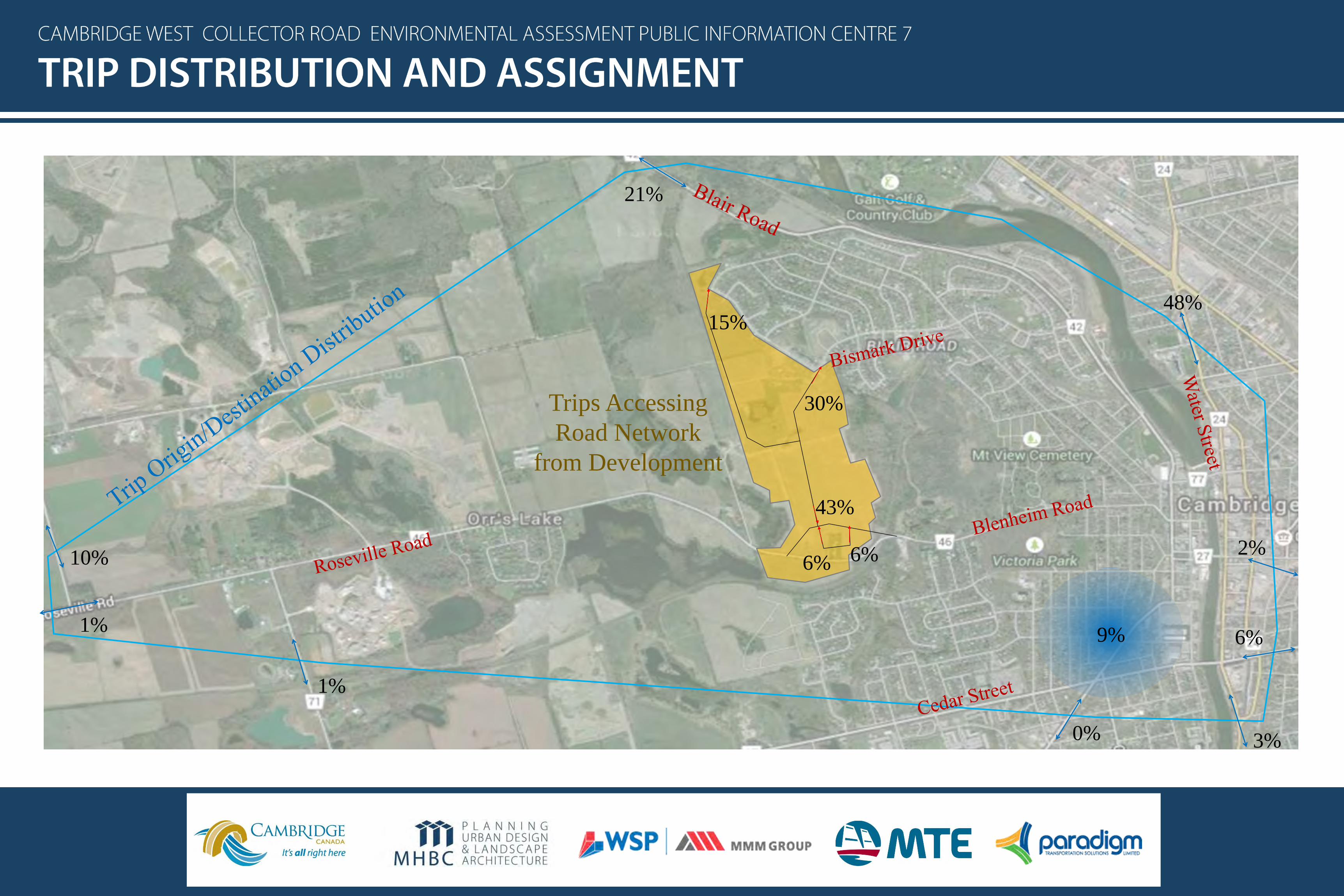
15%
30%
43%
6% 6%10%
1%
1%
0% 3%
6%
2%
48%
21%
9%
Trips Accessing
Road Network
from Development

Location ofDevelopment
Movements forecast to operate at LOS F or LOS E at the 2031 horizon.
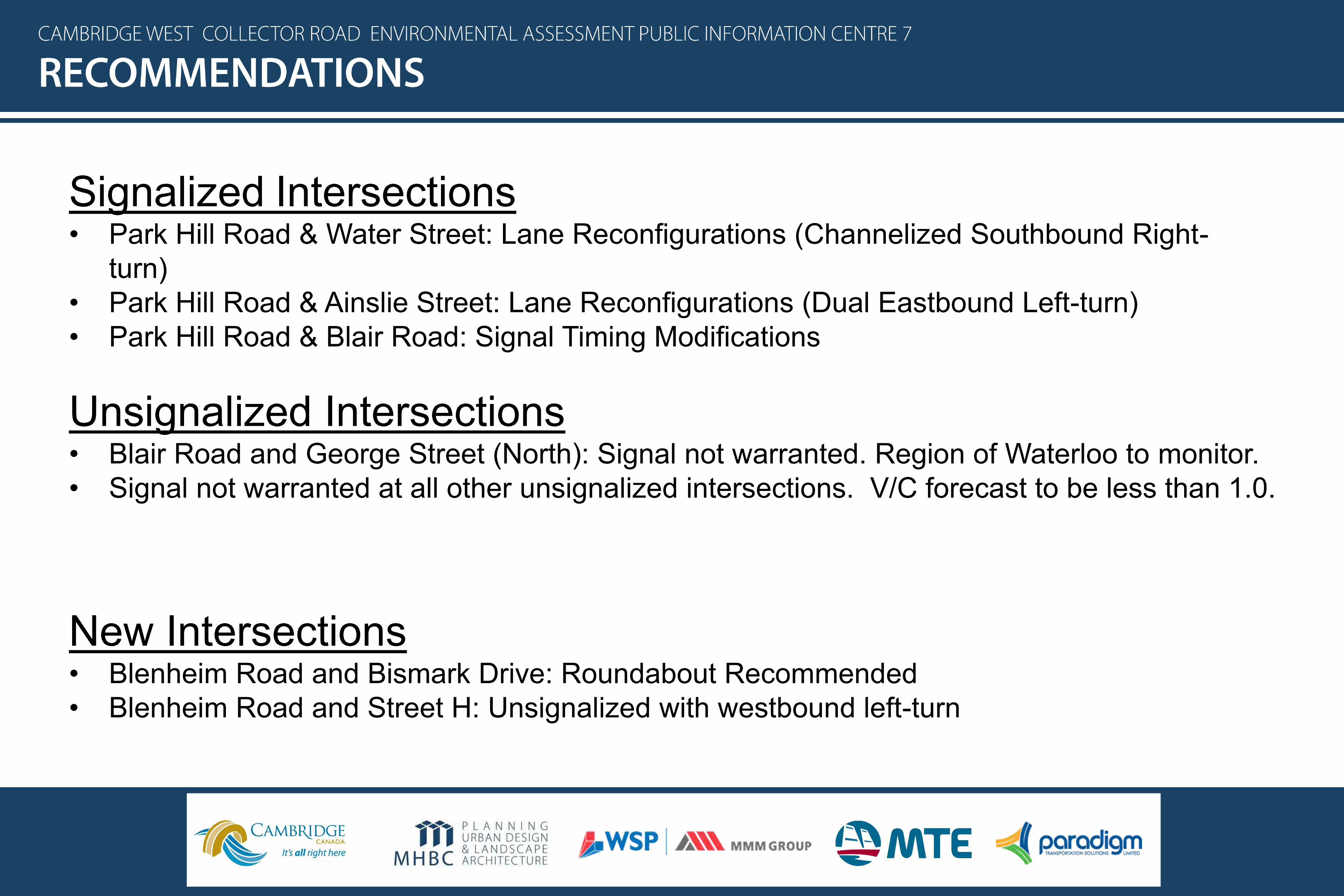
Signalized Intersections• Park Hill Road & Water Street: Lane Reconfigurations (Channelized Southbound Right-
turn)• Park Hill Road & Ainslie Street: Lane Reconfigurations (Dual Eastbound Left-turn)• Park Hill Road & Blair Road: Signal Timing Modifications
Unsignalized Intersections• Blair Road and George Street (North): Signal not warranted. Region of Waterloo to monitor.• Signal not warranted at all other unsignalized intersections. V/C forecast to be less than 1.0.
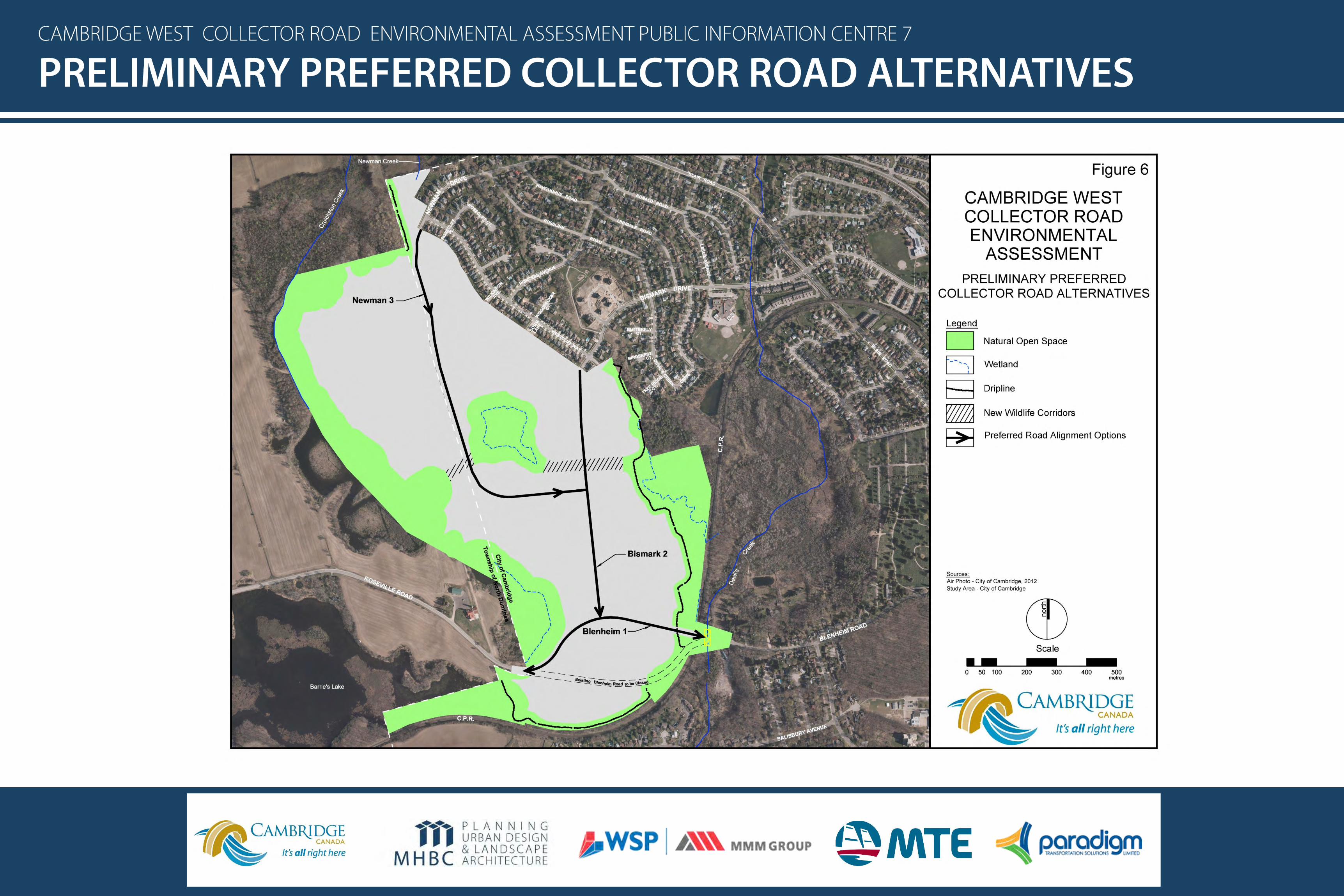
New Intersections• Blenheim Road and Bismark Drive: Roundabout Recommended• Blenheim Road and Street H: Unsignalized with westbound left-turn

•
•
•
•o
o
o
o
•
•
•
•
•
•
•
•
•
•
•
•
•
•
•
•

•
•
•
•
•
•
•
•
•
•
•
•
•
•
•
•
•
•
•
•
•
•

•
•
•
•
•
•
•
•
•
•
•
•

ItemMeets Criteria
Yes No
Respects the limits of the Blair-Bechtel-Cruickston Environmentally Sensitive Landscape (ESL) X
Conforms with the intent of the ESL Policy Framework X
Consistent with the decision making process associated with the designation of the Blair-
Bechtel-Cruickston ESLX
Avoids Core Natural Heritage features X
Avoids fragmenting the linear Open Space System (Cruickston Creek and Wetlands) X
Avoids encroachment onto Environmental Setbacks X
Avoids Fragmentation of the Agricultural Land Base X
Respects the Countryside Line X
Consistent with the Vision for the rare Charitable Preservation Reserve X
Consistent with the Regional Transportation Master Plan (RTMP) X
Constructible without the requirement to secure lands outside the Cambridge West
Community and within the rare Charitable Research ReserveX
Can address identified safety concerns at the Canadian Pacific Railway (CP) crossing X
Complies with engineering design standards X
Preferred from a sight distance and related road safety perspective X
Provides for efficient community design X
Provides for the efficient extension of services within proposed roads X
Provides for the efficient extension of transit X


•
•
•
