portland bay coastal infrastructure upgrade project
TRANSCRIPT

Design + Planning
Portland Bay Coastal Infrastructure Upgrade ProjectProject Information ReportPrepared for Glenelg Shire Council7th June 2011

Prepared for
Glenelg Shire Council
Prepared by
AECOM Australia Pty Ltd
Level 9, 8 Exhibition Street, Melbourne VIC 3000, Australia
T +61 3 9653 1234 F +61 3 9654 7117 www.aecom.com
ABN 20 093 846 925
7 JUNE 2011
AECOM in Australia and New Zealand is certi ed to the latest version of ISO9001 and ISO14001.
© AECOM Australia Pty Ltd (AECOM). All rights reserved.
AECOM has prepared this document for the sole use of the Client and for a speci c purpose, each as expressly stated in the document. No other party should rely on this document without the prior written consent of AECOM. AECOM undertakes no duty, nor accepts any responsibility, to any third party who may rely upon or use this document. This document has been prepared based on the Client’s description of its requirements and AECOM’s experience, having regard to assumptions that AECOM can reasonably be expected to make in accordance with sound professional principles. AECOM may also have relied upon information provided by the Client and other third parties to prepare this document, some of which may not have been veri ed. Subject to the above conditions, this document may be transmitted, reproduced or disseminated only in its entirety.
Portland Bay Coastal Infrastructure Upgrade ProjectProject Information Report

Contents
Executive Summary 4
01 Introduction 6 1.1 Purpose of this Report 6 1.2 Project Background 6
02 Project Assessment and Approvals Framework 10 2.1 Legislative Context 10 2.2 Glenelg Planning Scheme 10 2.3 Victorian Coastal Strategy 13
03 Consultation 20
04 Economic Analysis 21 4.1 Portland Bay Coastal Infrastructure Plan Business Case 21
05 Traf c Management 22
06 Environmental Assessments 24 6.1 Flora and Fauna Assessment 24 6.2 Portland Marine Ecosystem Survey 25
07 Cultural Heritage Impacts 28 7.1 Aboriginal Heritage 28 7.2 Historic Sites 28
08 Measures to Minimise Potential Impacts 30
09 Conclusion 32
A1 Legislative Context 34

AECOM4
This Project Information Report has been prepared to explain the Portland Bay Coastal Infrastructure Upgrade Project. This project has its basis in the Portland Bay Coastal Infrastructure Plan which was adopted by the Glenelg Shire Council in November 2007. The major drivers for the Coastal Infrastructure Upgrade Project include:• Improved management of commercial and recreational
boating within the harbour
• Realising opportunities for increased tourism within the harbour
• Better management of visitors and regular harbour users, including improved access and parking.
The project comprises:• A 70 berth oating marina
• Land reclamation, where the land is to be used for a range of community uses (to be determined following public consultation) and the parking of vehicles and recreational boating trailers during times of peak demand
• Permanent car and boat trailer parking on the existing reclaimed land opposite the Marine Discovery Centre
• A four lane boat ramp (for which funding has not yet been con rmed).
The project will also require the relocation and possible removal of some swing moorings to enable construction of the marina and safe boat movement in the con nes of the marina.
The key bene ts of the project include:• Increased tourism expenditure through better facilities
for visitors and recreational boat users
• Better facilities to support new tourism opportunities, such as cruise ships, eco-tourism businesses (charter operations for whales, seals, dolphins, and coastal scenery tours) and new recreational shing charter businesses
• Improved arrangements for some of the commercial shing eet
• Improved boat launching facilities for recreational boaters.
This report has been prepared concurrently with an application for approval of the project under the Coastal Management Act, with that application currently before the Department of Sustainability and Environment.
Council has considered a wide range of issues associated with the project with a number of technical studies completed. The key ndings of Council’s investigations are outlined in the following table.
Executive Summary
Existing Lagoon to be reclaimed

AECOM 5Portland Bay Coastal Infrastructure Upgrade ProjectProject Information Report
Issue Key FindingTraf c Management The proposed vehicle and boat trailer parking will signi cantly improve the current
parking arrangement, particularly during times of peak demand which lead to vehicles parking informally throughout the foreshore.
Flora and Fauna There were no ora species of State signi cance observed in the study area. The Hooded Plover was the only fauna species of conservation signi cance observed in the study area. Signi cant impact on the species or the species habitat is not expected from the proposed works. Council has been advised that referrals under the Environment Effects Act 1978 or the Environment Protection and Biodiversity Conservation Act 1999 are not required. Approval is also not required under the Flora and Fauna Guarantee Act 1988.
Marine Environment There will be minor localised impacts on the marine ecosystem during construction, particularly the piling associated with the marina. Operational impacts are likely to be minimal and limited largely to physical presence of the proposed structure.
European Cultural Heritage A site for the shipwreck of the Regia has been registered by Heritage Victoria in the south west portion of the activity area. A recent underwater survey commissioned by Council located a number of timber piles that have been cut off at sea bed level, located in proximity to the proposed marina. Advice from Heritage Victoria indicated a 20 metre separation distance needs to be maintained around the Regia and Consent to Damage is not required for the oating pontoon as it is unlikely to damage sub-surface deposits.
Aboriginal Cultural Heritage There are no recorded Aboriginal cultural heritage places within the study area. The landform of the project area has been subject to signi cant ground disturbance, therefore a Cultural Heritage Management Plan is not mandatory. Similarly, the development of the sea-bed within 200 metres of the high tide mark is exempt from a mandatory Cultural Heritage Management Plan.
View to proposed marina and car parking

AECOM6
01 Introduction
This Project Information Report has been prepared to explain the Portland Bay Coastal Infrastructure Upgrade Project, the required approvals, community consultation, the supporting technical studies for the project and measures to minimise impacts associated with the project.
1.2 Project BackgroundThe Portland Bay Coastal Infrastructure Upgrade Project has its basis in the Portland Bay Coastal Infrastructure Plan. The Coastal Infrastructure Plan was adopted by the Glenelg Shire Council (Council) in November 2007. The document provides a long term master plan for the future use and development of Portland’s foreshore. The Coastal Infrastructure Plan identi es the ways in which the community’s vision for the foreshore can be realised, as well as meeting policy and management directions for coastal areas in Victoria.
Council has recently completed several technical studies to support the development of the project and better de ne the optimal arrangement for recreational and commercial boating within Portland. These studies have led to re nements to the items identi ed in the Coastal Infrastructure Plan.
The Portland Bay Coastal Infrastructure Upgrade Project will lead to signi cant improvements in recreational and commercial boating facilities at Portland which are currently unable to appropriately cope with peak demands.
The project comprises the following buildings and works (as shown in Figure 1):
• A 70 berth oating marina (located immediately east of the Marine Discovery Centre and the existing car parking area)
• Reclamation of a lagoon on the foreshore to be used for boat trailers, associated with a future boat ramp, particularly in during peak times. This area is also intended to be used as a multi-purpose public foreshore area for community purposes (which will be determined through public consultation)
• Permanent car and boat trailer parking for approximately 120 spaces on the existing reclaimed land
• A four lane boat ramp (to be built on land exposed at low tide in order for the ramp to meet the water).
The project is to be developed in three stages. The rst stage involves the development of the marina and the landside parking. The construction of the marina and landside parking is jointly funded by Regional Development Victoria and Council.
The second stage involves land reclamation and construction of permanent car and boat trailer parking on existing reclaimed land and the establishment of a multi-purpose area on newly reclaimed land. The multi-purpose area will be used for car and boat trailer parking during peak times, for cruise ship coach parking, and for other community uses. The land reclamation will be assisted by the Port of Portland with the rst stage at no cost.
The Port of Portland intends to commence the rst phase of land reclamation in mid 2011 following approval under the Coastal Management Act 1995. Dredged spoil from a shipping berth within the Port will be used to reclaim land at the lagoon. The second phase of reclamation will also be undertaken by the Port of Portland using sand that the Port is required to move from outside the Port breakwater. This reclamation will occur during late 2011 to early 2012.
In the third stage a boat ramp will be built south-east of the existing reclaimed area. No funding has been allocated for this stage of the project at this point. Following the completion of the new boat ramp the boat and trailer parking area, immediately adjacent to the marina, will be converted to car parking for the marina users.
The project will require the relocation and possible removal of some swing moorings. This will enable the construction of the marina and safe boat movement within the bay.
1.1 Purpose of this Report

AECOM 7Portland Bay Coastal Infrastructure Upgrade ProjectProject Information Report
Marina1 70 no. berth oating marina (secure access)2 Publicly accessible pier3 40m large vessel berth4 Existing Floating jetty5 Potential Fuel berth6 55 no. permanent car/boat trailer parking7 Small wharf for heritage couta boats
Lagoon Reclamation8 Reclaimed area ll 40,000m2
(assisted by Port of Portland 2011/2012)9 Removal of rock wall10 120 no. permanent car/boat trailer parking 11 Multi-purpose area (community uses and over ow car and boat trailer parking during peak demand) 12 Proposed cycle/pedestrian path
Boat Ramp13 4 lane boat ramp14 Rock ll 400m215 Limestone/clean ll - 1530m216 Manoeuvring Area - Limestone/ Clean ll - 1870m2
12
4
6
7
8
9
10
11
12
13
14
1516
5
3
A
B
C
A B C
Maritime Discovery Centre (MDC)
Existing Toilet Facilities
Area Exposed at Low Tide
Existing Jetty
Existing Boatramp
Stage A (funded) Stage B (funded) Stage C (currently not funded)
Portland Harbour
Regia
Existing Toilet Facilities (9-5)
Figure 1 - Project Scope

AECOM8
12
3 4
5
1 70 no. berth oating marina2 Resurfaced with asphalt - 55 no. permanent car/boat trailer parking 3 Grassed Multi-purpose area (community uses and over ow car and boat trailer parking during peak demand)4 Resurfaced with asphalt - 120 no. permanent car/boat trailer parking5 4 lane boat ramp
Portland Harbour
100m
Figure 2 - Landscape Concept

AECOM 9Portland Bay Coastal Infrastructure Upgrade ProjectProject Information Report
45
32
1
3
4
1 25
Figure 3 - Oblique View of Project Scope
Figure 4 - View of Project Scope from Bentinck Street

AECOM10
02 Project Assessment and Approvals Framework
A review of environmental, planning and heritage legislation has been undertaken to determine the issues that need to be addressed in planning for this project and to identify any necessary approvals. Appendix A provides a summary of this legislation and the advice Council has received con rming that the only approval required for the project is under the Coastal Management Act 1995.
2.1.1 Coastal Management Act 1995The Coastal Management Act 1995 provides for the planning and management of the Victoria’s coast. The Act’s objectives include:• to plan for and manage the use of Victoria’s coastal
resources on a sustainable basis for recreation, conservation, tourism, commerce and similar uses in appropriate areas
• to protect and maintain areas of environmental signi cance on the coast including its ecological, geomorphological, geological, cultural and landscape features.
• to facilitate the development of a range of facilities for improved recreation and tourism;
The Act provides a co-ordinated approach to the approvals required for the use and development of coastal Crown land. Pursuant to this Act, consent is required from the regional Department of Sustainability and Environment (DSE) of ce for all uses and development of coastal Crown land (i.e. within 200m of the high tide mark) and the seabed of coastal waters within three nautical miles of the Victorian coastline. This report has been prepared concurrently with an application for approval under the Coastal Management Act 1995.
2.1.2 Other legislative considerations Heritage Act 1995 & Historic Shipwrecks Act 1976 (Cwlth)A site for the shipwreck of the Regia has been registered by Heritage Victoria in the south west portion of the activity area. A recent underwater survey commissioned by Council located a number of timber piles located in proximity to the proposed marina. Advice is currently being sought from Heritage Victoria regarding as to the implications of this discovery. Any heritage approvals required will be sought from Heritage Victoria.
The proposed works have been designed to ensure an adequate separation distance between the proposed land reclamation and the Regia site is maintained.
Although planning approval is not required for the project, a review of the project against the Glenelg Planning Scheme is worthwhile. The Glenelg Planning Scheme sets out relevant considerations for land use and development including State and local policies which this project should be consistent with. The following provides a summary of State and local planning policy directions from the Glenelg Planning Scheme that are relevant to the project.
2.2.1 State Planning Policy Framework The State Planning Policy Framework (SPPF) outlines the purpose, goal, application and decision making framework for planning in Victoria. The SPPF seeks to ensure that the objectives of planning foster appropriate land use and development outcomes by addressing aspects of economic, environmental and social well-being. In making decisions, authorities should endeavour to integrate the range of relevant policies and balance con icting objectives in favour of net community bene t and sustainable development for the bene t of present and future generations.
The SPPF discusses the importance of coastal areas and the need to protect them. The value of coastal areas to the community is to be enhanced and natural coastal resources are to be used in a sustainable manner. In order to achieve this there needs to be coordinated land use planning in accordance with the Victorian Coastal Strategy 2008 and the Coastal Management Act 1995. These documents provide a clear direction for future sustainable use of the coast, including recreation, conservation and tourism, protecting areas of environmental signi cance and identifying opportunities for improved facilities.
Development of coastal areas needs to demonstrate how it will conserve, protect and seek to enhance ecological values, as well as protect cultural heritage places, including Aboriginal places and historic shipwrecks.
The SPPF supports coastal tourism and encourages suitably located and designed coastal and marine tourism opportunities with facilities accessible by all people. Developments in coastal areas need to be of an appropriate scale, use and intensity and minimise impacts on the natural, visual, environmental and coastal character.
The SPPF recognises that development should plan for the potential coastal impacts of climate change including sea level rise of not less than 0.8 metres by 2100, and be designed to take into account the effects of climate change, such as the combined effects of tides, storm surges, coastal processes and local conditions.
2.1 Legislative Context 2.2 Glenelg Planning Scheme

AECOM 11Portland Bay Coastal Infrastructure Upgrade ProjectProject Information Report
2.2.2 Local Planning Policy FrameworkMunicipal Strategic Statement The Municipal Strategic Statement (MSS) outlines the vision and land use and development directions for the Glenelg Shire over the next 15 years. The MSS also explains how the zone and overlay provisions implement the Shire’s vision.
The MSS identi es the need for Council to take into consideration recreational and tourist development opportunities provided by the coast and the need to manage uses to conserve coastal landscape and environmental qualities. Planning should support tourism development and facilities, whilst ensuring the sustainable management and protection of coastal areas. Strategies to achieve this include protecting areas of environmental signi cance and protecting coastal areas from inappropriate development. Landscaping and good design in buildings and works are also promoted.
The MSS recognises that Portland is strategically located between Adelaide and Melbourne. The shing industry and tourism are important sectors of the local economy, with a major initiative being to encourage the further growth of industries such as the shing and marine industries.
The MSS identi es the importance of heritage and protecting the cultural and natural features of Portland. To achieve this, heritage places need to be conserved and enhanced.
The MSS supports the Port of Portland and encourages the continued expansion of the capacity of the Port. To effectively achieve this, there needs to be a plan for the long term protection and development of the foreshore. The planning scheme acknowledges there has been a lack of coordination of major transport infrastructure and traf c management has become a major issue during times of peak demand.
Tourism is identi ed as a major growth industry in the Shire of Glenelg. Tourism should be focused on Portland’s foreshore which should be promoted as a major tourist asset. Potential for eco-tourism opportunities should also be promoted.
Local Planning Policies A Local Planning Policy for economic development identi es tourism as an important industry in the Shire’s economy and highlights potential for further growth. Building on the strengths of the region, expanding tourist facilities and recreational activities and recognising the coast is a major asset in the development of the Shire’s tourism industry are key considerations that should be achieved. Planning for new developments in coastal areas must undertake a comprehensive planning process.
Comment The project supports the State and Local Planning Policy Frameworks, particularly the conservation of coastal areas and supporting coastal tourism through the development of improved facilities in an appropriate location.
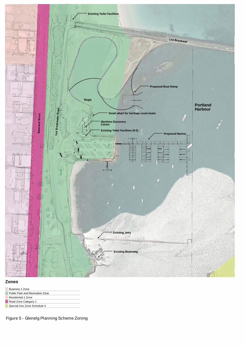
2.2.3 Planning Scheme Controls Clause 36.03 - Public Park and Recreation ZoneThe project is part located on land and waters in the Public Park and Recreation Zone (PPRZ) of the Glenelg Planning Scheme, as well as part located in waters outside of the planning scheme, where there are no planning controls. This is shown in Figure 5. The purpose of the PPRZ is:
• To implement the State Planning Policy Framework and the Local Planning Policy Framework, including the Municipal Strategic Statement and local planning policies.
• To recognise areas for public recreation and open space.
• To protect and conserve areas of signi cance where appropriate.
The project is consistent with this zone as it provides for public boating and recreation activities, whilst ensuring the natural environment is protected.
Approval is not required for the project under this zoning if the use, buildings and works are undertaken on behalf of the public land manager. Council is the public land manager for this area.
There are no overlays affecting this site.
AECOM12
1 Business 1 Zone 2 Public Park and Recreation Zone3 Residential 1 Zone4 Road Zone Category 15 Special Use Zone Schedule 4
Maritime Discovery Centre
Small wharf for heritage couta boats
Proposed Marina
Proposed Boat Ramp
Existing Toilet Facilities
Existing Toilet Facilities (9-5)
Existing Jetty
Existing Boatramp
Zones
Portland Harbour
Regia
Figure 5 - Glenelg Planning Scheme Zoning

AECOM 13Portland Bay Coastal Infrastructure Upgrade ProjectProject Information Report
The Victorian Coastal Strategy (2008) provides a management framework for Victoria’s coastline. The Victorian Coastal Strategy has been established under the Coastal Management Act 1995. It provides a vision for the long-term planning, management and use of coastal and marine environments. As outlined in the Victorian Coastal Strategy, the vision for Victoria’s coast is:
“A biologically and culturally rich, diverse coastal, estuarine and marine environment that is managed for its protection, sustainable use and enjoyment today and for future generations”.
The Victorian Coastal Strategy identi es three signi cant issues affecting Victoria’s coast - climate change, population and growth, and marine ecological integrity. There is also a hierarchy of principles for coastal, estuarine and marine planning and management to assist with local development. Many of these principles are relevant to this project and have been adhered to in its planning phases. The principles are:
1. Provide for the protection of signi cant environmental and cultural valuesThis principle seeks the protection of Aboriginal and non-Aboriginal cultural heritage values. An Archaeological Assessment commissioned by Council in 2010 identi ed there are no known registered sites of Aboriginal signi cance within the project area. A recent underwater survey failed to identify any signi cant maritime sites, however around 30 timber piles were identi ed, some of which are in the vacinity of the marina development. Heritage Victoria advised Consent to Damage is not required for the oating pontoon as it is unlikely to damage sub-surface deposits.
2. Undertake integrated planning and provide clear direction for the futureThe Portland Bay Coastal Infrastructure Plan provides an integrated planning approach for the foreshore area and the Port of Portland. Climate change is also an important consideration that needs to be planned for. The Victorian Coastal Strategy outlines that sea level rise of not less than 0.8 metres by 2100 needs to be planned for to allow for the combined effects of tides, storm surges and topographical characteristics. No buildings are involved in this stage of the project and all works will provide for a sea level rise of not less than the 0.8 metres by 2100.
3. Ensure the sustainable use of natural coastal resources
The project area is a highly modi ed environment and will not impact natural resources providing that the mitigation measures identi ed in the technical studies commissioned by Council are implemented (refer to Section 8.0). This project supports boating, recreation and improved access. The marina, new access for boating and additional parking will improve the functionality of this coastal area.
4. Ensure development on the coast is located within existing modi ed and resilient environments where the demand for development is evident and the impact can be managed
The project is located within a highly modi ed environment which includes former reclaimed land. There is demand for improved recreational boating and parking. Impacts associated with the project can be managed through a number of mitigation measures, as outlined in Section 8.0 of this report.
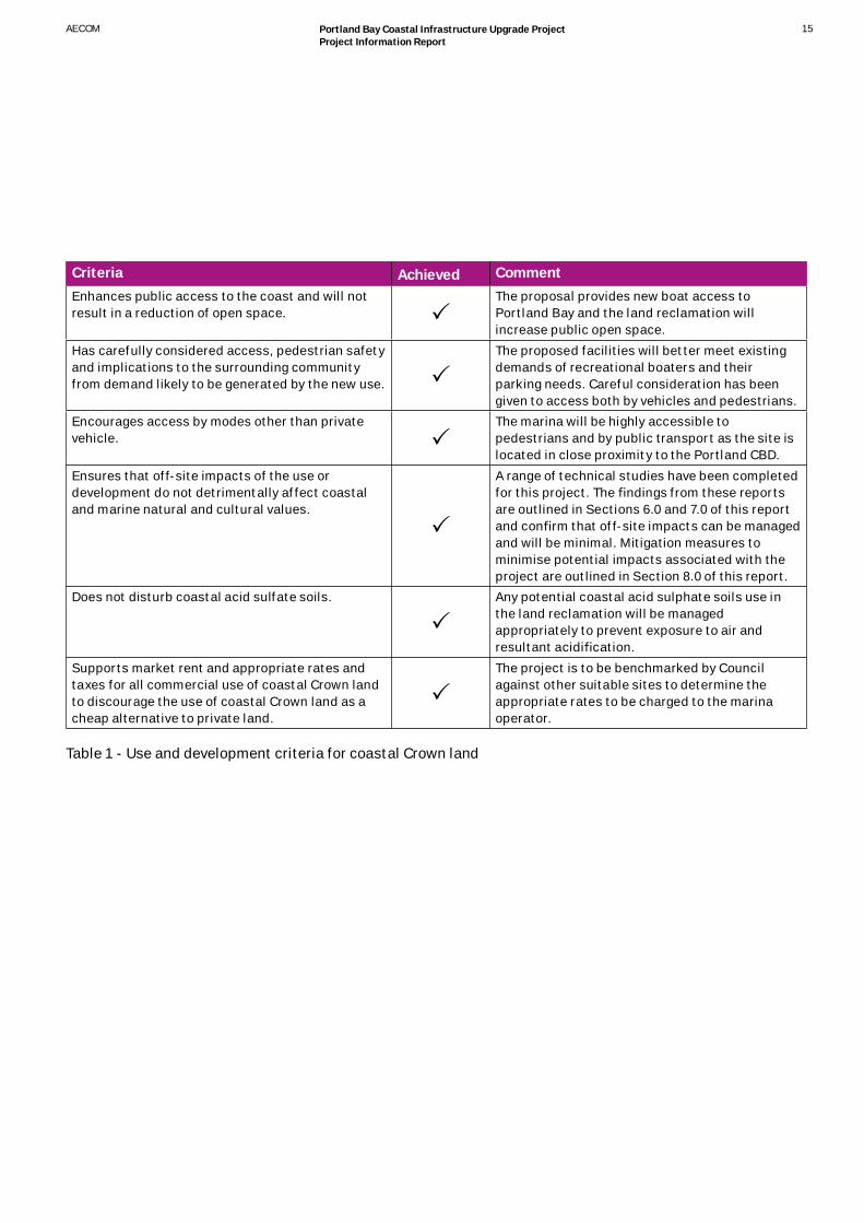
This principle includes use and development criteria that apply to coastal Crown land. These are outlined in Table 1. This table demonstrates how the project has met each criteria. The project has been appropriately designed and will enhance the community and tourist use of Portland’s foreshore.
2.3 Victorian Coastal Strategy

AECOM14
Criteria Achieved CommentHas demonstrated need to be sited on the coast and requires a coastal location to function.
The marina and boat ramp are coastal dependant.
Located within an activity node or recreation node. The project area is located within a recreation node in close proximity to the commercial centre of a major regional centre.
Ful ls an identi able need or demand that cannot be met elsewhere.
There is a demonstrated need for the marina and boat ramp in this area.
Demonstrates considerable net community and public bene t and ensures equity in community access to new and existing use and development.
The project provides net community bene t by providing better facilities to support recreational boating and tourism and community use opportunities. This will lead to increased tourism expenditure.
Involved consultation with local and broader community.
The project is based in the Portland Bay Coastal Infrastructure Plan for which extensive consultation wwas undertaken.
Facilitates multi-use of sites and existing infrastructure and the rationalisation of existing buildings and car parks without resulting in over-use.
The project includes a multi-purpose public foreshore area for uses to be identi ed by the community.
Facilitates improvements of sites or existing developments that have poor environmental or social performance.
The project will produce a better outcome for the community by improving traf c conditions in peak tourist season. Environmental improvements will result from the project as the improved facilities for parking and for recreational boating will also include better facilities for waste management.
Is consistent with the requirements of Coastal Action Plans, management plans and the relevant planning scheme.
There are several relevant Coastal Action Plans (CAP), including the Western Victoria Boating CAP, South Western Victoria CAP and Glenelg Shire CAP. The project is consistent with the CAPs. These are discussed in the following sections.
Exhibits excellence in siting and design, complements or integrates with the coastal landscape and setting, maintains important public views, vistas and sightlines and is set back from the coast as far as practicable in line with vulnerability assessments.
The siting of the marina, boat ramp and associated facilities have been carefully considered and compliment the existing setting which includes the Marine Discovery Centre.
Will not be vulnerable to climate change risk within the lifespan of the new development.
The proposal allows for the minimum of 0.8 metre sea level rise by 2100.
AECOM 15Portland Bay Coastal Infrastructure Upgrade ProjectProject Information Report
Criteria Achieved CommentEnhances public access to the coast and will not result in a reduction of open space.
The proposal provides new boat access to Portland Bay and the land reclamation will increase public open space.
Has carefully considered access, pedestrian safety and implications to the surrounding community from demand likely to be generated by the new use.
The proposed facilities will better meet existing demands of recreational boaters and their parking needs. Careful consideration has been given to access both by vehicles and pedestrians.
Encourages access by modes other than private vehicle.
The marina will be highly accessible to pedestrians and by public transport as the site is located in close proximity to the Portland CBD.
Ensures that off-site impacts of the use or development do not detrimentally affect coastal and marine natural and cultural values.
A range of technical studies have been completed for this project. The ndings from these reports are outlined in Sections 6.0 and 7.0 of this report and con rm that off-site impacts can be managed and will be minimal. Mitigation measures to minimise potential impacts associated with the project are outlined in Section 8.0 of this report.
Does not disturb coastal acid sulfate soils. Any potential coastal acid sulphate soils use in the land reclamation will be managed appropriately to prevent exposure to air and resultant acidi cation.
Supports market rent and appropriate rates and taxes for all commercial use of coastal Crown land to discourage the use of coastal Crown land as a cheap alternative to private land.
The project is to be benchmarked by Council against other suitable sites to determine the appropriate rates to be charged to the marina operator.
Table 1 - Use and development criteria for coastal Crown land

AECOM16
2.3.1 Western Victoria Boating Coastal Action Plan (2010)The Western Victoria Boating Coastal Action Plan (Boating CAP), prepared by the Western Coastal Board, provides a framework for guiding the provision of improved boating facilities in the western coastal region of Victoria, including Portland, Portland Bay and the foreshore area. The Boating CAP was developed in accordance with the Coastal Management Act 1995 and implements key policies of the Victorian Coastal Strategy.
The vision for recreational boating facilities to the year 2035 in the Western Coastal Region is:
“A network of strategically located, sustainable and safe boating access and facilities which meet user needs, that is managed to protect and enhance the dynamic coastal environment, giving due consideration to the impacts of climate change.”
A recreational boating facility hierarchy has been established in the Boating CAP which recognises the Port of Portland as one of the four Victorian commercial shipping ports. Portland is classed as a State Marine Precinct that incorporates facilities of National, State, regional and local signi cance, as shown in Figure 6. The criteria for a State Marine Precinct are: • A State level of signi cance that provides a key boating
and tourist destination
• A high level of investment as a key boating activity centre
• An exceptional level of service that caters for a wide range of boating activity and skill levels
• Provides a safe harbour and controlled water space
• Services a wide catchment area at major population centres
• Provides all tide access
• Provides public access to the facility and coastal environment and servicing facilities
• Commercial shipping activities may be present.
Portland has also been given a high priority in the new boating facilities hierarchy. This is based on:• Its current and future levels of population
• Its capacity to add signi cantly to the spread and diversity of facilities within the network and hierarchy
• Its consistency with strategic planning policy
• Its capacity to add considerably to the net public bene t and public amenity and safety
• Its potential to support the local and regional economy, particularly in regard to employment and increased visitation.
The Boating CAP recognises that the implementation of the Portland Bay Coastal Infrastructure Plan would provide a major upgrade to existing facilities. A new boat ramp, commercial marina and additional car and trailer parking would reduce pressure on the existing facilities.

AECOM 17Portland Bay Coastal Infrastructure Upgrade ProjectProject Information Report
Figure 6 - Recreational Boating Facility Hierarchy 2035
Source: Western Coastal Board, 2010, Western Victoria Boating Coastal Action Plan

AECOM18
2.3.2 South Western Victoria Coastal Action Plan (2002)The South Western Victorian Coastal Action Plan aims to improve the management of the coastal and marine environment through changes to policy and activities. The plan covers coastal and marine areas from Moonlight Head to the South Australian border (including Portland Bay). The plan focuses on management activities and identi es seven critical issues, primarily relating to the management of the coastline, namely:
• Implementation mechanisms
• Regional signi cant values
• Marine planning
• Planning for development
• Agency management
• Aboriginal cultural heritage
In relation to Portland Bay the plan identi es the need to implement the recommendations of the Glenelg Shire Coastal Action Plan.
2.3.3 Glenelg Shire Coastal Action Plan (2004)The Glenelg Shire Coastal Action Plan (GSCAP) extends along the coastline of Glenelg Shire. The GSCAP has been prepared in accordance with the Coastal Management Act 1995 and describes strategic principles for coastal use, development and conservation and provides a framework for achieving this.
Portland’s waterfront is recognised as a diverse area that is important to the State, regional and local community for its recreational and economic values. The Shire’s coast is used for an array of recreational and tourism uses, including wildlife attraction such as seal and whale watching tours. The marine environment is a valuable economic resource that sustains a viable commercial shing eet in Portland. The Port of Portland, one of the four Victorian commercial shipping ports, is also a major economic focus for the Shire.
Relevant issues, desired outcomes of the GSCAP and how the project achieves this are presented in Table 2 .

AECOM 19Portland Bay Coastal Infrastructure Upgrade ProjectProject Information Report
Issues Desired Outcome How the project achieves thisCoastal access The provision of a diverse range of access
facilities to and along the coast that caters for the range of recreational and tourism activities in an environmentally sustainable manner that considers public risk.
The project will improve access to the bay for boat users by providing new ramps and a marina. Additional car spaces will be provided, which improve access and traf c management along Portland’s foreshore.
Foreshore infrastructure A range of safe and well maintained foreshore infrastructure that facilitates a range of recreation and tourism uses in a variety of locations
The project will provide new infrastructure for recreational boaters and the new marina will support new tourism opportunities.
Signi cant ora and fauna species
The range of native ora and fauna species found along the Glenelg Shire coast are protected from threatening processes.
A ora and fauna assessment was commissioned to identify species of State and national signi cance. There were no ora species of State or national signi cance observed in the study area. Seagrasses are present in Portland Bay, however the total area of seagrasses is relatively minor (approximately 1% of the total seagrass found in the study area). The Hooded Plover was observed in the study area and is listed as threatened under the Flora and Fauna Guarantee Act 1988, however the proposed works is not expected to have a signi cant impact on this bird species.
Recreation and tourism The provision of a range of coastal recreation and tourism opportunities within the Shire.
The project provides improved facilities for recreational boaters and increased tourism opportunities, such as for eco-tourism businesses.
Indigenous and European Cultural Heritage
Improved protection of heritage sites (both Aboriginal and European).
A heritage study was commissioned to identify any Aboriginal and European cultural heritage impacts. No registered Aboriginal cultural heritage places are within the project area.
The presence of sites with European cultural heritage values has been thoroughly investigated including through the commissioning of an underwater survey. This study has improved our understanding of heritage sites within the project area and Heritage Victoria is being consulted to ensure that heritage sites are protected. Refer to Section 7.0 for further details.
Table 2 - Glenelg Shire Coastal Action Plan - Isssues and Outcomes

AECOM20
03 ConsultationConsultation has been a continuing aspect of this project. Extensive consultation was undertaken throughout the preparation of the Portland Bay Coastal Infrastructure Plan. The consultation activities included twenty six stakeholder interviews, meetings with stakeholder groups, two resident discussion groups, community and stakeholder design workshops, and Councillor brie ng workshops. Steering Committee Meetings also formed part of the consultation process. The Steering Committee included representation from: Glenelg Shire Council, Department of Sustainability and Environment, Regional Development Victoria, Department of Infrastructure (now known as the Department of Transport), and the Greater Green Triangle Area Consultative Committee.
This consultation aided in the development of the vision for the Portland Bay Foreshore and the preparation of preferred design options. The draft Coastal Infrastructure Plan, was placed on exhibition for public comment. Submissions to the draft were considered and changes made for the nal Coastal Infrastructure Plan, which was approved by Council in November 2007.
Stakeholder consultation was also undertaken when developing the Business Case for the Coastal Infrastructure Plan. Stakeholders included Department of Transport, Marine Safety Victoria, Department Sustainability and Environment, Department of Treasury and Finance, Regional Development Victoria and Tourism Victoria.
Key outcomes from the stakeholder consultation, as outlined in the Coastal Infrastructure Plan and the Business Case, include: • All stakeholders supported retention of public access to
the Lee Breakwater, as they believe it is important for local residents and visitors.
• There was support for locating the cray sh eet to a new marina.
• All stakeholders were supportive of decommissioning the Marina Jetty.
Key messages from residents include:• The need for better access and connectivity along the
foreshore area. This includes catering for people of all mobility needs.
• The need for a more balanced approach for shared access to the foreshore, as it is currently car dominated. There needs to be more consideration for pedestrians, cyclists and boats.
• Land based shing opportunities and boating needs are equally important for locals.
• Tourism opportunities along the foreshore need to be capitalised on and recognition needs to be given to the signi cant contribution the foreshore and its activities make to Portland.
A community information workshop was held on Saturday 21st May 2011 at the Portland Visitor Information Centre for the Portland Bay Coastal Infrastructure Upgrade Project. The aim of the information session was to provide interested members of the community with an opportunity to nd about the project and provide feedback, particularly in relation to the proposed land reclamation and what the community would like to see this open space used for.
Six speci c groups were also identi ed as important stakeholder groups for this project, namely:• Portland Sport and Game Fishing Club
• Portland Yacht Club
• Portland Professional Fisherman’s Association
• Boat Owner’s Action Team
• Maritime Heritage Advisory Committee
• Portland Eco Trust.
Meetings were held with each of these groups during April and May 2011. The Gunditj Mirring Traditional Owners Aboriginal Corporation was also identi ed as an important stakeholder group, and meetings with them will take place as required.
Based on the consultation undertaken, it can be concluded that:• The majority of stakeholder groups (5 out of 6) support the
project activities in general.
• There is unanimous support from identi ed stakeholder groups and the local community (those that attended the workshop) on the development of the marina.
• There is recognition of the need for a new boat ramp and support for it to be in the proposed location. There was no strong opposition to the location of the proposed new boat ramp.
• The written responses (from those at the workshop) indicate signi cant opposition to the proposal to reclaim land in the lagoon area, however there is some support for the proposal from some people at the workshop and ve of the identi ed stakeholder groups. The major concerns around the proposed lagoon reclamation are the impact on environmental values of the lagoon area and that it was not identi ed as a project in the Portland Bay Coastal Infrastructure Project (2007). It is important to note that no environmental studies were undertaken as part of the Coastal Infrastructure Plan. The Marine Ecosystem Survey completed in 2011 details that the lagoon has limited environmental value, while the spoil ground and deeper edge has more signi cant environmental value (refer to Section 8.3.2 for more information).

AECOM 21Portland Bay Coastal Infrastructure Upgrade ProjectProject Information Report
04 Economic Analysis4.1 Portland Bay Coastal Infrastructure Plan Business Case The Portland Bay Coastal Infrastructure Plan Business Case was prepared by Biruu in 2010. The Business Case provides Council and the State Government with the information needed to make an informed decision on the implementation of the overall Portland Bay Coastal Infrastructure Plan.
The Business Case was prepared in association with Council with input from the Department of Innovation, Industry and Regional Development, Regional Development Victoria and the Department of Treasury & Finance.
The Business Case identi ed that each summer there is an increasing number of tourists from Victoria and interstate visiting Portland. There is also an increasing number of recreational shers, particularly shing for tuna. This is placing increasing pressure on the existing facilities and creating traf c management issues. Portland may also become a stop-off for cruise ship operators on route between Adelaide and Melbourne.
The Business Case identi es the major drivers for the project, namely: • Expansion of the Port of Portland
• Inadequate facilities which are preventing tourism and economic opportunities
• Access and safety issues created by increasing numbers of visitors and recreational shers
• There is a need for “Sunday market” to make Portland more attractive to cruise ships.
The bene ts of the project include:• Increased tourism opportunities, such as eco-tourism
businesses and tourism expenditure
• Economic opportunities associated with the new marina berthing opportunities for charter boats, commercial shing boats and recreational boating.
• Providing direct and indirect jobs, including jobs during the construction of the project.

AECOM22
05 Traf c ManagementTraf c management is a key consideration of this project. In summer the number of pedestrians, cars, trailers and boats exceeds the capacity of water access, parking and roads. Victoria Police have recently been required on busy summer weekend to help manage traf c congestion along the foreshore areas.
The Australian Standard for marinas for vessels of up to 50 metres in length (AS 3962-2001 Guidelines for the design of marinas) has been used as a guiding document for parking and traf c issues. This document speci es different car parking requirements for different marina activities, including boat ramps.
Table 3 outlines the parking requirements at public boat launching ramps. A four lane boat ramp is proposed as part of the Portland Bay Coastal Infrastructure Upgrade Project. The Australia Standards states that 120 spaces should be provided for a four lane boat ramp. A total of 120 permanent spaces are proposed to be provided with additional grassed area for over ow parking.
Table 3 - Parking at public boat launching ramp
Area classi cation Number of car/trailer spaces for each ramp lane (AS 3962-2001)
Proposed number of ramps
Total number of car spaces to be provided (AS 3962-2001)
Proposed car/trailer spaces
Urban 30-40 4 120 120

AECOM 23Portland Bay Coastal Infrastructure Upgrade ProjectProject Information Report
The proposed marina will have a total of approximately 70 wet berths. The associated car parking requirements are outlined in Table 4. A total of 21 spaces would be required. The proposal provides 22 car spaces.
Table 4 - Car parking for marina activities
Tables 3 and 4 demonstrate that suf cient car and car/boat trailer parking is proposed to be provided for the new marina and four lane boat ramp as speci ed in the relevant Australian Standard.
The project will greatly improve the current traf c concerns and parking capacity and accommodate demandfor over 98% of the year. However, the additional car parking for this project is unlikely to be adequate during peak times for shing (2% of the year), which can attract up to 300 car and
boat trailers. Land constraints and the need to balance the various uses of the foreshore render it impossible to cater completely for peak times.
Area classi cation Number of car parking spaces to be provided (AS 3962-2001)
Total number of berths/employees
Total number of car spaces to be provided (AS 3962-2001)
Proposed car spaces
Spaces to be provided per wet berth for boats
0.3-0.6 70 21 - 42 22
Spaces to be provided per employee
0.5 2 1 1

AECOM24
06 Environmental Assessments Environmental assessments for the project were completed in 2010, speci cally a Flora and Fauna Assessment and Marine Ecosystem Survey. The key ndings, recommendations and actions identi ed in these reports are summarised below.
6.1 Flora and Fauna AssessmentThe Flora and Fauna Assessment investigated native ora and fauna within the project area, potential Net gain requirements and statutory obligations regarding species of state and national signi cance.
Ecological Conditions The area is a highly modi ed environment which features areas of reclaimed land and highly altered coastal foreshore.
The assessment found that the project area is located on the border between Warrnambool Plain Bioregion and the Victorian Plain Bioregion.
Ecological Vegetation Class (EVC) mapping for the region shows a narrow band of Coastal Headland Scrub (EVC 163) in the study area. The reclaimed area surrounding the constructed lagoon is mapped as a coastal land ll/sand accretion area. The Hooded Plover, Nankeen Night Herron and the Musk Duck use the coastal land ll area for habitat.
Detailed ora and fauna records for the study area (with a 1km radius) supplied by DSE identi ed 196 native ora species including 6 species listed under the Environment Protection and Biodiversity Conservation Act 1999 (EPBC Act), 14 species listed under the Flora and Fauna Guarantee Act 1988 (FFG Act) and 61 exotic ora species.
There were also 32 species with conservation status in Victoria based on the DSE Advisory List identi ed in the DSE search. Some of the species in the advisory lists are also listed as threatened under the FFG Act.
The fauna dataset (1km search buffer of site) included 101 native species (excluding marine species) and 7 exotic species that may occur within the study area. Of the 102 native species, 81 of the species recorded are bird species. Conservation signi cant fauna species included 4 EPBC Act listed species (4 vulnerable), and 12 species listed under the FFG Act.
Field Observations Field observations were made during spring 2010. There were scatted native trees and shrubs present within the study area however most of these had been planted and the vegetation are dominated by exotic species.
68 ora species and 7 fauna species were observed during the site visit. The Thinornis rubricollis (Hooded Plover), Tadorna tadornoides (Australian Shelduck), Haematopus longirostris (Pied Oystercatcher), Hirundo neoxena’s (Welcome Swallows) and Larus novaehollandiae’s (Silver Gull) and an unidenti ed Cormorant species were observed in the study area.
Planted vegetation provides foraging and nesting habitat for birds, whilst also providing shelter and dispersal habitat for native fauna.
Species of conservation signi canceThere were no ora species of state signi cance observed in the study area.
The Hooded Plover was the only fauna species of conservation signi cance observed in the study area. The species is listed as a marine species under the EPBC Act, and is listed as Threatened under the FFG Act. It is assumed that given the vegetation in the study area, this area would be used temporarily as a resting site and the species may opportunistically feed in the area. It would not serve as breeding habitat or critical habitat for this species. Signi cant impact on the species or the species habitat is not expected from the proposed works. A referral under the FFG Act is not required. Similarity, a referral under the EPBC Act is not recommended because there are no matters of national environmental signi cance recorded within the study area that are likely to be signi cantly impacted by the proposed works.
Recommendations There were no remnant patches of vegetation as de ned by the Department of Sustainability and Environment in the document titles Native vegetation – Guide for assessment of referred planning permit applications (DSE 2006). Hence the report recommends that the area should be treated as a revegetation site and be given a low conservation value.

AECOM 25Portland Bay Coastal Infrastructure Upgrade ProjectProject Information Report
The Portland Marine Ecosystem Survey looked at the presence of rare, threatened or listed marine species, the presence of any exotic pest species, the state of the existing environment, tidal ow observations, and the occurrence and distribution of marine biota. Potential impacts of the marina development were also identi ed in this study.
Ecological Conditions Portland Bay is a highly modi ed environment and the breakwaters have created relatively sheltered conditions on a section of coastline usually subject to large oceanic swells. Similarly, the lagoon was constructed from reclaimed dredge spoil and represents a highly modi ed environment with the Harbour.
Field surveys of the current ecological conditions were undertaken on the 15th-16th of July 2010 and 4th - 5th May 2011. The habitat types identi ed during the eld surveys included rock revetment (intertidal), breakwater (subtidal), seagrass, algal beds, soft (bare) sediments, piled and oating structure and lagoon.
Species of conservation signi canceThe lagoon and areas adjacent to the lagoon were inspected for their biodiversity values. The total area of seagrass inside the lagoon is relatively small and estimated to be no greater than 20 square metres, with no seagrass in the main section of the lagoon basin. A moderate sized seagrass bed, conservatively estimated to be 7,000 square metres, occurs over the spoil mound (adjacent to the lagoon). The seagrass habitat at Henty Beach is conservatively estimated at 11,200 square metres. Refer Figure7 to for areas of seagrass within Portland Bay
A species of conservation signi cance observed during the survey was the Australian Fur Seal, Arctocephalus pusillus. Other species that have been observed during previous surveys are the Southern Right Whale, Eubalaena australis and the Little Penguin, Eudyptula minor.
The survey found that Syngnathids (which include seahorses, seadragons and pipe sh) may also occur within the study area but were not observed during the survey. All syngnathid species are listed under the EPBC Act 1999. In Victoria, syngnathids are listed (and protected) under the Fisheries Act 1995.
6.2 Portland Marine Ecosystem Survey

AECOM26
Figure 7 Ground-Truthed Seagrass Habitat in Portland HarbourSource: Worley Parsons, 2011, Portland Marine Ecosystem Survey

AECOM 27Portland Bay Coastal Infrastructure Upgrade ProjectProject Information Report
Impacts The loss of subtidal habitat caused by the in lling of the lagoon is not considered signi cant as the area has little ecological value in its current condition. Similarly, the reclamation associated with the construction of the boat ramp is not considered to result in signi cant seagrass loss, as it represents less than 10% of seagrass currently inside Portland Harbour. The seagrass beds at Henty beach are unlikely to be affected by construction. To minimise impact on the seagrass, Council is considering moving the boat ramp a few metres to the north to avoid thicker seagrass at the south-east corner of the existing reclaimed land.
During construction there will be impacts on the marine ecosystem, particularly due to the piling associated with the marina. These impacts are likely to be noise and turbidity from the pile driving. This type of noise is readily transmitted underwater and may deter sh and seals from approaching the construction area. Most other species, particularly invertebrates will be unaffected. The main operational impact of the marina is likely to be due to the physical presence of the proposed marina structure. Operational impacts relating to the presence of boats and their use have the potential to impact on ecological communities within the harbour. The report identi es that the maintenance of good water quality will be necessary and effective environmental management needs to be established for boating activities, such as refuelling, waste disposal and maintenance.

AECOM28
07 Cultural Heritage ImpactsAn archaeological assessment was commissioned in 2010 to identify known Aboriginal and non-indigenous cultural heritage values and sites within the study area and assess the impact of the proposed development.
7.1 Aboriginal HeritageAboriginal Affairs Victoria maintains a register called the Victorian Aboriginal Heritage Register, which includes all recorded Aboriginal archaeological sites in Victoria. There are two Aboriginal cultural heritage places recorded on the Victorian Aboriginal Heritage Register (7221-0860 (waste silcrete ake) and 7221-0870 (damaged coastal int core)) within close proximity to the proposed works, however both of these are greater than 50 metres from the study area and will not be impacted by the proposal.
The archaeological assessment found that the landform within and around the study area is heavily modi ed. The original ground surface has been subject to signi cant ground disturbance and the reclaimed areas within the study area comprise imported material or original soil that has been disturbed. Due to these extensive modi cations of foreshore it is unlikely that in situ Aboriginal cultural heritage would exist and a Cultural Heritage Management Plan is not required to be prepared.
Legal advice obtained by Council regarding Native Title has advised that the provisions of the Native Title Act 1993 do not apply to the project area, given that it is located on reclaimed land or sea bed.
7.2 Historic Sites There are ve registered historic sites within or near the activity area (refer Table 5), including the Regia Shipwreck, located in the south west portion of the study area, another shipwreck the Australasia whose location is unknown may also be in the proximity of the activity area.
The brig Regia was wrecked close to the shore of Portland on the 16th November 1860. The brig was built in India in 1835 and is now landlocked as a result of sand deposits created following the construction of the Lee Breakwater. A Conservation Plan was commissioned by Council and completed in 2002 by Cosmos Archaeology for the Regia. This plan provides speci c details regarding the location of the wreck and appropriate management practices.
An underwater survey commissioned by Council in 2011 identi ed approximately 30 timber piles cut off at sea bed level, including some located within the marina development area.
Advice was sought from Heritage Victoria as to any heritage approval requirements given the European heritage sites within close proximity to the activity area. Heritage Victoria advised a separation distance of 20 metres is to be provided around the Regia (the project will provide a 30 metre separation distance) and Consent to Damage is not required for the oating pontoon as it is unlikely to damage subsurface deposits.
The study area does not include any heritage places identi ed in the Glenelg Planning Scheme or listed on the National Trust of Australia (Victoria) register. In the vicinity of the study area there was a former rail pier and the remains may have been covered by sand. Despite the known location of the pier there is insuf cient information for it to be recognised as an archaeological site.

AECOM 29Portland Bay Coastal Infrastructure Upgrade ProjectProject Information Report
Heritage Victoria Site ID
Site Name Site Type Description Location
H7221-0197 Railway Bridge Cutting
Railway Railway Bridge and hill cutting
Outside study area
H7221-0268 Frederick Court Drain Drain Trench lined with bones and ceramics associated with a cottage
Outside study area
H7221-0493 Cliff Street Tunnel Drain Drain linking gaol to foreshore
Outside study area
H7721-0860 Andersons Point Whaling Station
Commercial Buildings Buildings associated with whaling
Outside study area
S567 Regia Shipwreck Shipwreck Submerged shipwreck
South west portion of the activity area immediately adjacent to the reclamation area (which has been designed to provide a separation distance of 30 metres from the wreck site)
S48 Australasia Shipwreck Highly dispersed Unknown
Table 5 - Historic Site

AECOM30
08 Measures to Minimise Potential ImpactsThe potential environmental impacts of the project have been identi ed in the various technical studies commissioned by Council. These potential impacts will be mitigated through the preparation of a Construction Environmental Management Plan and an Operational Environmental Management Plan. It is expected that the consent required from the Department of Sustainability and Environment under the Coastal Management Act 1995 will specify conditions to ensure that potential environmental impacts are effectively mitigated.
The Construction Environmental Management Plan will provide the framework for managing all construction activities. This document will be prepared by Council prior to the commencement of construction and will be an evolving and living document which will be updated upon selection/nomination of the Contractor appointed for the construction works.
An Operational Environmental Management Plan, which will be based on the Construction Environmental Management Plan will also be prepared by Council and the future operator of the marina to ensure that any potential ongoing environmental impacts of the operation of the marina, boat ramp and landside areas are appropriately mitigated. The Operational Environmental Management Plan will consider management activities such as those associated with any charter vessels that may operate from the marina, the activities of commercial shing vessels, waste management and fuel handling.
Table 6 identi es speci c measures that should be implemented to minimise the impacts of the project.

AECOM 31Portland Bay Coastal Infrastructure Upgrade ProjectProject Information Report
Impact /Risk Mitigation Outcome Responsibility Pollution associated with boating activities, including refuelling, waste disposal, maintenance and cleaning
Operational Environmental Management Plan to be introduced to prevent boating pollution
Maintaining the current condition of the marine ecosystem
Council
Environmental risks during construction phase including impacts of sediment movement during land reclamation works
Preparation of a Construction Environmental Management Plan which will detail all sediment control measures including the installation of appropriate sediment control barriers across the mouth of the lagoon
Minimising potential environmental impacts
Project Manager
Relocation of some swing moorings for the development of the marina and boat traf c
Retain a number of swing moorings and provide marina berths for existing swing mooring users to consider
This will assist the community to continue to have access to swing moorings
Council
The need for appropriate security arrangements at the marina
The main marina jetty will be publicly accessible however the nger piers that extend from the main jetty will have restricted access by way of a security syste
There will be an appropriate public access to the marina and security for boat owners
Council
Impact on European cultural heritage values
Allow for a 30 metre separation distance between the known location of the Regia and the proposed reclamation works, including adequate retention of imported material
To ensure heritage sites are not impacted upon by proposed works
Council
Impact on seagrass Consider moving the boat ramp a few metres to the north
Minimising impact on seagrass outside the lagoon
Council
Table 6 - Measure to minimise potential impacts

AECOM32
09 Conclusion
The Portland Bay Coastal Infrastructure Upgrade Project will provide for a signi cant improvement in recreational and commercial boating facilities at Portland which are currently unable to cope with peak demands. The key components of the project are a 70 berth oating marina, reclamation of a lagoon, permanent car and boat trailer parking, four lane boat ramp and associated oating jetties.
The key bene ts of the project include:
• Increased tourism expenditure through better facilities for visitors and recreational boat users
• New tourism opportunities, such as eco-tourism businesses (whales, seals, dolphins and coastal scenery tours) and new recreational shing charter businesses
• Improved arrangements the commercial shing eet, including improved security arrangements
• Improved boat launching facilities for recreational boaters.
Coastal Management Act consent is required for the project and this is currently being sought. The Glenelg Planning Scheme supports coastal tourism and recreation through the development of improved facilities. The project will improve traf c management issues during the peak tourist seasons. The project also meets the requirements of the Victorian Coastal Strategy by protecting signi cant environmental and cultural values, having consideration of climate change impacts, supporting boating and recreation, and improving access to coastal infrastructure.
A consultation program was undertaken for the Portland Bay Coastal Infrastructure Plan in 2007 from which this project has its origin. Further information sessions and consultation was undertaken for this project, particularly in relation to the land reclamation area and potential community uses for this multi-use area.
A range of technical studies were completed for the project which demonstrate that potential environmental impacts can be appropriately managed. These studies also con rmed the signi cant economic bene ts of the project.
The project is consistent with relevant State and local policies including the Victorian Coastal Strategy, the Glenelg Planning Scheme and Coastal Action Plans that apply to this area.
The heritage values of the area have been carefully considered with guidance from Heritage Victoria.

AECOM 33Portland Bay Coastal Infrastructure Upgrade ProjectProject Information Report
Figure 8 - Oblique View of Project Scope


ALegislative Context

Responsible Government Agency
Legislation / Interest
Comment on applicability and implications for the project
Commonwealth
Department of Sustainability, Environment, Water, Population and Communities (SEWPAC)
Environment Protection and Biodiversity Conservation Act 1999
This Act would be triggered if there is deemed to be a ‘signi cant impact’ to any one of eight matters of national environmental signi cance. A referral would need to be prepared for SEWPAC if there was any doubt regarding a potential impact on a nationally listed species.
Worley Parsons (2010) advised Council following a ora and fauna assessment that referral under this Act is not necessary.
Native Title Act 1993 Legal advice has been obtained by Council advising that the provisions of this Act do not apply to the project area given that it is located on reclaimed land or sea bed.
State
Department of Planning and Community Development (DPCD)
Environment Effects Act 1978
This Act requires that signi cant environmental effects are investigated.
Council has been advised that the project would not require assessment under this Act as the proposal will not have a signi cant environmental effect.
Department of Sustainability and Environment (DSE)
Coastal Management Act 1995
Consent is required for all uses and development of coastal Crown land (i.e. within 200m of the high tide mark) and the seabed of coastal waters within three nautical miles of the Victorian coastline.
Approval is required for the project under this Act.
Flora and Fauna Guarantee Act 1988
This Act protects Victorian ora and fauna listed under this Act from direct impacts from development and potentially threatening processes. Any works that may affect listed species or communities require a permit.
Worley Parsons (2010) advised Council following a ora and fauna assessment that approval would not be required under this legislation.
Land Act 1958 The Act provides for the occupation of unreserved Crown lands and authorises the issue of various types of leases and licenses.
Council has con rmed that the Crown land within the project area is managed by Council and that approval is not required under this legislation.
Crown Land (Reserves) Act 1978
This Act addresses the reservation and management of Crown lands in Victoria. All works within Crown land require permission, and in some cases a lease.
Council has con rmed that the Crown land within the project area is managed by Council and that approval is not required under this legislation.
Summary of potential approval requirements

Responsible Government Agency
Legislation / Interest
Comment on applicability and implications for the project
Glenelg Shire Council Planning and Environment Act 1987
Planning approval is not required for the proposal given that the project area is either zoned Public Park and Recreation Zone (for which approval is not required for works undertaken on behalf of the public land manager) or is outside the boundary of the Glenelg Planning Scheme.
Aboriginal Affairs Victoria Aboriginal Heritage Act 2006
This Act protects and manages Aboriginal sites and artefacts within Victoria and mapping prepared by Aboriginal Affairs Victoria identi es land of cultural heritage sensitivity, including coastal land within the project area. Where land of cultural heritage sensitivity is proposed to be disturbed the preparation of a Cultural Heritage Management Plan may be required.Terraculture Heritage Consultants (2010) advised that as the site has been signi cantly disturbed by prior activities, a Cultural Heritage Management Plan is not required to be prepared.
Heritage Victoria Heritage Act 1995 & Historic Shipwrecks Act 1976 (Cwlth)
These Acts provide legislative frameworks for the protection of historic shipwrecks and other sites of European cultural heritage value.
A site for the shipwreck of the Regia has been registered by Heritage Victoria in the south west portion of the activity area. A recent underwater survey commissioned by Council located a number of timber piles located in proximity to the proposed marina.
Advice is currently being sought from Heritage Victoria regarding as to the implications of this discovery. Any heritage approvals required will be sought from Heritage Victoria.

www.aecom.com
AUSTRALIAVictoriaLevel 45, 80 Collins StreetMelbourne VIC 3000T 61 3 9653 8222
New South Wales Level 8, 17 York StreetSydney NSW 2000T 61 2 8023 9333
QueenslandLevel 8, 540 Wickham StreetFortitude Valley QLD 4006T 61 7 3553 2000
Level 3 Platinum Building14-18 Duporth AvenueMaroochydore QLD 4558T 7 5479 4405
Western Australia 3 Forrest PlacePerth WA 6000 T 61 8 6430 2900
NEW ZEALAND47 George Street Newmarket, Auckland 1023T 64 9 379 1200
Level 6, 76 Cashel StreetChristchurch 8140T 64 3 363 8500